Bridge Statistics for Baileyton, Tennessee (TN)
Condition, Traffic, Stress, Structural Evaluation, Project Costs
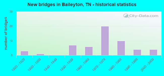
- New bridges - historical statistics
- 31920-1929
- 11930-1939
- 71950-1959
- 61960-1969
- 201970-1979
- 101980-1989
- 41990-1999
- 42000-2009
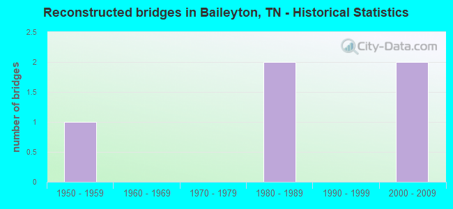
- Reconstructed bridges - Historical Statistics
- 11950-1959
- 01960-1969
- 01970-1979
- 21980-1989
- 01990-1999
- 22000-2009
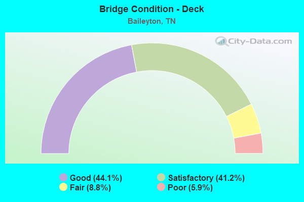
- Bridge Condition - Deck
- 44.1%Good
- 41.2%Satisfactory
- 8.8%Fair
- 5.9%Poor
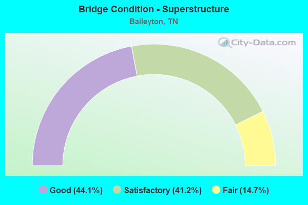
- Bridge Condition - Superstructure
- 44.1%Good
- 41.2%Satisfactory
- 14.7%Fair
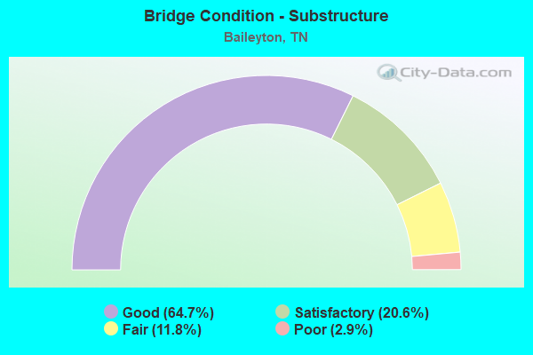
- Bridge Condition - Substructure
- 64.7%Good
- 20.6%Satisfactory
- 11.8%Fair
- 2.9%Poor
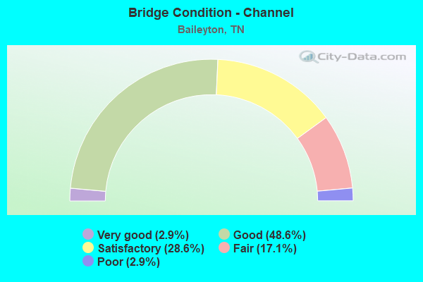
- Bridge Condition - Channel
- 2.9%Very good
- 48.6%Good
- 28.6%Satisfactory
- 17.1%Fair
- 2.9%Poor
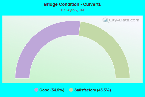
- Bridge Condition - Culverts
- 54.5%Good
- 45.5%Satisfactory
Find on map >> Show street view
Structure Number: 37S24630001, Location: NEAR NEW HOPE (Lat: 36.389733, Lng: -82.848483), Route carried "on" structure: State highway 347, Year Built: 1958, Status: Posted for load, Structure Length: 3.47m (11.38ft), Average Daily Traffic: 555 (year 2020), Truck Traffic: 5%, Average Future Daily Traffic: 888 (year 2041), Design Load: HS 15, Features Intersected: NORTH FORK CREEK
Minimum Vertical Clearance: 30+ m (98+ ft), Kilometerpoint: 16.319, Lanes on structure: 2, Owner: State Highway Agency, Approaching Roadway Width: 6.7m (22.0ft), Material/Design: Concrete, Design/Construction: Tee Beam, Number Of Spans In Main Unit: 4, Length of Maximum Span: 8.8m (28.9ft), Curb-To-Curb Width: 7.4m (24.3ft), Out-to-Out Width: 8.7m (28.5ft)
Condition: Deck: Poor, Superstructure: Fair, Substructure: Fair, Channel: Fair, Operating Rating: 23.7 metric tons, Method Used To Determine Operating Rating: Load and Resistance Factor Rating (LRFR) rating reported by rating factor(RF) method using HL-93 loadings, Inventory Rating: 18.1 metric tons, Method Used To Determine Inventory Rating: Load and Resistance Factor Rating (LRFR) rating reported by rating factor(RF) method using HL-93 loadings, Structural Evaluation: Somewhat better than minimum adequacy, Deck Geometry: Meets minimum limits, Waterway Adequacy: Equal to present minimum criteria, Approach Roadway Alignment: Equal to present desirable criteria, Length Of Structure Improvement: 3.47m (11.38ft), Designated Inspection Frequency: Every 24 months, Inspection Date: September 2020, Bridge Improvement Cost: $159,000, Roadway Improvement Cost: $16,000, Total Project Cost: $239,000 ( Estimate for 2021), Deck Structure Type: Concrete Cast-file-Place, Wearing Surface/Protective System: Wearing Surface: Monolithic Concrete
Find on map >> Show street view
Structure Number: 37S24630003, Location: BTWN NEW HOPE & VAN HILL (Lat: 36.394767, Lng: -82.827750), Route carried "on" structure: State highway 347, Year Built: 1958, Status: Open, Structure Length: 4.82m (15.81ft), Average Daily Traffic: 555 (year 2020), Truck Traffic: 5%, Average Future Daily Traffic: 944 (year 2040), Design Load: HS 15, Features Intersected: BEECH CREEK
Minimum Vertical Clearance: 30+ m (98+ ft), Kilometerpoint: 18.556, Lanes on structure: 2, Owner: State Highway Agency, Approaching Roadway Width: 7.6m (24.9ft), Material/Design: Concrete, Design/Construction: Tee Beam, Number Of Spans In Main Unit: 5, Length of Maximum Span: 13.1m (43.0ft), Curb-To-Curb Width: 7.4m (24.3ft), Out-to-Out Width: 8.7m (28.5ft)
Condition: Deck: Satisfactory, Superstructure: Satisfactory, Substructure: Fair, Channel: Good, Operating Rating: 36.0 metric tons, Method Used To Determine Operating Rating: Load Factor (LF), Inventory Rating: 21.6 metric tons, Method Used To Determine Inventory Rating: Load Factor (LF), Structural Evaluation: Somewhat better than minimum adequacy, Deck Geometry: Meets minimum limits, Waterway Adequacy: Better than present minimum criteria, Approach Roadway Alignment: Equal to present desirable criteria, Length Of Structure Improvement: 4.82m (15.81ft), Designated Inspection Frequency: Every 24 months, Inspection Date: September 2020, Bridge Improvement Cost: $171,000, Roadway Improvement Cost: $18,000, Total Project Cost: $257,000 ( Estimate for 2020), Deck Structure Type: Concrete Cast-file-Place, Wearing Surface/Protective System: Wearing Surface: Bituminous
Find on map >> Show street view
Structure Number: 37S24630005, Location: NEAR VAN HILL (Lat: 36.394333, Lng: -82.819117), Route carried "on" structure: State highway 347, Year Built: 1958, Status: Open, Structure Length: 4.39m (14.40ft), Average Daily Traffic: 555 (year 2020), Truck Traffic: 5%, Average Future Daily Traffic: 944 (year 2040), Design Load: HS 15, Features Intersected: BEECH CREEK
Minimum Vertical Clearance: 30+ m (98+ ft), Kilometerpoint: 19.715, Lanes on structure: 2, Owner: State Highway Agency, Approaching Roadway Width: 7.6m (24.9ft), Skew: 1 degrees, Material/Design: Concrete, Design/Construction: Tee Beam, Number Of Spans In Main Unit: 5, Length of Maximum Span: 8.8m (28.9ft), Curb-To-Curb Width: 7.4m (24.3ft), Out-to-Out Width: 8.7m (28.5ft)
Condition: Deck: Satisfactory, Superstructure: Satisfactory, Substructure: Fair, Channel: Good, Operating Rating: 42.3 metric tons, Method Used To Determine Operating Rating: Load Factor (LF), Inventory Rating: 25.2 metric tons, Method Used To Determine Inventory Rating: Load Factor (LF), Structural Evaluation: Somewhat better than minimum adequacy, Deck Geometry: Meets minimum limits, Waterway Adequacy: Better than present minimum criteria, Approach Roadway Alignment: Equal to present minimum criteria, Length Of Structure Improvement: 4.39m (14.40ft), Designated Inspection Frequency: Every 24 months, Inspection Date: September 2020, Bridge Improvement Cost: $153,000, Roadway Improvement Cost: $16,000, Total Project Cost: $230,000 ( Estimate for 2020), Deck Structure Type: Concrete Cast-file-Place, Wearing Surface/Protective System: Wearing Surface: Bituminous
Find on map >> Show street view
Structure Number: 37S24630007, Location: 1.0 M SE OF WASHINGTON CO (Lat: 36.394167, Lng: -82.794117), Route carried "on" structure: State highway 347, Year Built: 1958, Status: Open, Structure Length: 3.54m (11.61ft), Average Daily Traffic: 325 (year 2020), Truck Traffic: 5%, Average Future Daily Traffic: 520 (year 2041), Design Load: HS 15, Features Intersected: BEECH CREEK
Minimum Vertical Clearance: 30+ m (98+ ft), Kilometerpoint: 22.595, Lanes on structure: 2, Owner: State Highway Agency, Approaching Roadway Width: 7.0m (23.0ft), Skew: 1 degrees, Material/Design: Concrete, Design/Construction: Tee Beam, Number Of Spans In Main Unit: 4, Length of Maximum Span: 8.8m (28.9ft), Curb-To-Curb Width: 7.4m (24.3ft), Out-to-Out Width: 8.7m (28.5ft)
Condition: Deck: Satisfactory, Superstructure: Satisfactory, Substructure: Satisfactory, Channel: Good, Operating Rating: 29.2 metric tons, Method Used To Determine Operating Rating: Load and Resistance Factor Rating (LRFR) rating reported by rating factor(RF) method using HL-93 loadings, Inventory Rating: 22.4 metric tons, Method Used To Determine Inventory Rating: Load and Resistance Factor Rating (LRFR) rating reported by rating factor(RF) method using HL-93 loadings, Structural Evaluation: Equal to present minimum criteria, Deck Geometry: Somewhat better than minimum adequacy, Waterway Adequacy: Better than present minimum criteria, Approach Roadway Alignment: Equal to present desirable criteria, Length Of Structure Improvement: 3.54m (11.61ft), Designated Inspection Frequency: Every 24 months, Inspection Date: September 2020, Bridge Improvement Cost: $501,000, Roadway Improvement Cost: $51,000, Total Project Cost: $752,000 ( Estimate for 2021), Deck Structure Type: Concrete Cast-file-Place, Wearing Surface/Protective System: Wearing Surface: Bituminous
Find on map >> Show street view
Structure Number: 30I00810035, Location: NEAR GREENVILLE TENN. (Lat: 36.308067, Lng: -82.874000), Route carried "under" structure: Interstate 81, Year Built: 1971, Structure Length: 0. m, Average Daily Traffic: 37,438 (year 2020), Truck Traffic: 44%, Features Intersected: OTTWAY RD (2592), Facility Carried by Structure: NFA 2592
Minimum Vertical Clearance: 4.90m (16.08ft), Kilometerpoint: 24.205, Lanes on structure: 2, Lanes under structure: 4, Material/Design: Prestressed concrete continuous, Design/Construction: Box Beam or Girders - Multiple, Length of Maximum Span: 42.7m (140.1ft)
Find on map >> Show street view
Structure Number: 30I00810039, Location: 3 M SW OF SR 172 EXIT (Lat: 36.299900, Lng: -82.877200), Route carried "under" structure: County highway 178, Year Built: 1968, Structure Length: 0. m, Average Daily Traffic: 230 (year 2022), Truck Traffic: 2%, Features Intersected: I81 RT LN, Facility Carried by Structure: I81
Minimum Vertical Clearance: 4.55m (14.93ft), Kilometerpoint: 0.391, Lanes on structure: 2, Lanes under structure: 2, Material/Design: Concrete continuous, Design/Construction: Tee Beam, Length of Maximum Span: 18.3m (60.0ft)
Find on map >> Show street view
Structure Number: 30I0081004, Location: 3 M SW OF SR 172 EXIT (Lat: 36.300417, Lng: -82.877717), Route carried "under" structure: County highway 178, Year Built: 1968, Structure Length: 0. m, Average Daily Traffic: 230 (year 2022), Truck Traffic: 2%, Features Intersected: I81 LF LN, Facility Carried by Structure: I81
Minimum Vertical Clearance: 4.55m (14.93ft), Kilometerpoint: 0.320, Lanes on structure: 2, Lanes under structure: 2, Material/Design: Concrete continuous, Design/Construction: Tee Beam, Length of Maximum Span: 17.7m (58.1ft)
Find on map >> Show street view
Structure Number: 30I00810041, Location: NEAR GREENVILLE TENN. (Lat: 36.308483, Lng: -82.858967), Route carried "under" structure: Interstate 81, Year Built: 1971, Structure Length: 0. m, Average Daily Traffic: 37,438 (year 2020), Truck Traffic: 44%, Features Intersected: BERNARD RD (A181)
Minimum Vertical Clearance: 4.93m (16.17ft), Kilometerpoint: 27.649, Lanes on structure: 2, Lanes under structure: 4, Material/Design: Prestressed concrete continuous, Design/Construction: Box Beam or Girders - Multiple, Length of Maximum Span: 30.8m (101.0ft)
Find on map >> Show street view
Structure Number: 30I00810045, Location: NEAR BAILEYTOWN (Lat: 36.323033, Lng: -82.832833), Route carried "under" structure: Interstate 81, Year Built: 1972, Structure Length: 0. m, Average Daily Traffic: 37,438 (year 2020), Truck Traffic: 44%, Features Intersected: SR 172 / I81 RL, Facility Carried by Structure: FAS 172
Minimum Vertical Clearance: 4.98m (16.34ft), Kilometerpoint: 30.465, Lanes on structure: 2, Lanes under structure: 2, Material/Design: Concrete continuous, Design/Construction: Box Beam or Girders - Multiple, Length of Maximum Span: 31.1m (102.0ft)
Find on map >> Show street view
Structure Number: 30I00810046, Location: NEAR BAILEYTOWN (Lat: 36.323600, Lng: -82.833133), Route carried "under" structure: Interstate 81, Year Built: 1972, Structure Length: 0. m, Average Daily Traffic: 37,438 (year 2020), Truck Traffic: 44%, Features Intersected: SR 172 / I81 LL, Facility Carried by Structure: FAS 172
Minimum Vertical Clearance: 5.16m (16.93ft), Kilometerpoint: 30.465, Lanes on structure: 2, Lanes under structure: 2, Material/Design: Concrete continuous, Design/Construction: Box Beam or Girders - Multiple, Length of Maximum Span: 20.7m (67.9ft)
Find on map >> Show street view
Structure Number: 30I00810049, Location: NEAR BAILEYTOWN (Lat: 36.326967, Lng: -82.828250), Route carried "under" structure: Interstate 81, Year Built: 1972, Structure Length: 0. m, Average Daily Traffic: 39,838 (year 2020), Truck Traffic: 42%, Features Intersected: JUD DOTY RD (1236), Facility Carried by Structure: NFA 1236
Minimum Vertical Clearance: 4.98m (16.34ft), Kilometerpoint: 31.141, Lanes on structure: 2, Lanes under structure: 6, Material/Design: Concrete continuous, Design/Construction: Box Beam or Girders - Multiple, Length of Maximum Span: 38.1m (125.0ft)
Find on map >> Show street view
Structure Number: 30I00810051, Location: 1.5 M E OF SR 172 EXIT (Lat: 36.335233, Lng: -82.811017), Route carried "under" structure: County highway 321, Year Built: 1970, Structure Length: 0. m, Average Daily Traffic: 150 (year 2022), Truck Traffic: 2%, Features Intersected: I81 RT LN, Facility Carried by Structure: I81
Minimum Vertical Clearance: 6.15m (20.18ft), Kilometerpoint: 2.929, Lanes on structure: 2, Lanes under structure: 2, Material/Design: Concrete continuous, Design/Construction: Tee Beam, Length of Maximum Span: 19.5m (64.0ft)
Find on map >> Show street view
Structure Number: 30I00810052, Location: 1.5 M E OF SR 172 EXIT (Lat: 36.335717, Lng: -82.811200), Route carried "under" structure: County highway 321, Year Built: 1970, Structure Length: 0. m, Average Daily Traffic: 150 (year 2022), Truck Traffic: 2%, Features Intersected: I81 LF LN, Facility Carried by Structure: I81
Minimum Vertical Clearance: 4.41m (14.47ft), Kilometerpoint: 2.984, Lanes on structure: 2, Lanes under structure: 2, Material/Design: Concrete continuous, Design/Construction: Tee Beam, Length of Maximum Span: 17.4m (57.1ft)
Find on map >> Show street view
Structure Number: 30I00810053, Location: NEAR GREENVILLE TENN. (Lat: 36.343767, Lng: -82.787933), Route carried "under" structure: Interstate 81, Year Built: 1972, Structure Length: 0. m, Average Daily Traffic: 39,838 (year 2020), Truck Traffic: 42%, Features Intersected: LOST MTN. PK (2583), Facility Carried by Structure: NFA 2583
Minimum Vertical Clearance: 5.03m (16.50ft), Kilometerpoint: 35.180, Lanes on structure: 2, Lanes under structure: 4, Material/Design: Prestressed concrete continuous, Design/Construction: Box Beam or Girders - Multiple, Length of Maximum Span: 32.9m (107.9ft)