Bridge Statistics for Alvarado, Texas (TX)
Condition, Traffic, Stress, Structural Evaluation, Project Costs
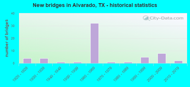
- New bridges - historical statistics
- 41920-1929
- 41930-1939
- 11940-1949
- 11950-1959
- 321960-1969
- 11970-1979
- 11980-1989
- 51990-1999
- 82000-2009
- 22010-2019

- Reconstructed bridges - Historical Statistics
- 11930-1939
- 01940-1949
- 11950-1959
- 01960-1969
- 01970-1979
- 41980-1989
- 51990-1999
- 12000-2009


- Bridge Condition - Deck
- 6.1%Very good
- 78.8%Good
- 6.1%Satisfactory
- 9.1%Fair

- Bridge Condition - Superstructure
- 12.1%Very good
- 54.5%Good
- 27.3%Satisfactory
- 6.1%Fair

- Bridge Condition - Substructure
- 3.0%Very good
- 51.5%Good
- 42.4%Satisfactory
- 3.0%Fair

- Bridge Condition - Channel
- 8.3%Very good
- 30.6%Good
- 55.6%Satisfactory
- 5.6%Fair

- Bridge Condition - Culverts
- 56.3%Good
- 37.5%Satisfactory
- 6.3%Fair
Find on map >> Show street view
Structure Number: 21270001403193, Location: 1.2 MI N OF US 67 (Lat: 32.429958, Lng: -97.238142), Route carried "on" structure: Interstate , Year Built: 1963, Year Reconstructed: 2007, Status: Open, Structure Length: 7.25m (23.79ft), Average Daily Traffic: 1,720 (year 2013), Average Future Daily Traffic: 1,770 (year 2033), Design Load: H 15, Features Intersected: IH 35W, Facility Carried by Structure: CR 604
Minimum Vertical Clearance: 30+ m (98+ ft), Kilometerpoint: 11.938, Lanes on structure: 2, Lanes under structure: 4, Owner: State Highway Agency, Approaching Roadway Width: 9.1m (29.9ft), Material/Design: Steel continuous, Design/Construction: Stringer/Multi-beam, Number Of Spans In Main Unit: 4, Length of Maximum Span: 18.3m (60.0ft), Curb-To-Curb Width: 8.3m (27.2ft), Out-to-Out Width: 9.1m (29.9ft)
Condition: Deck: Good, Superstructure: Good, Substructure: Good, Operating Rating: 37.2 metric tons, Method Used To Determine Operating Rating: Load Factor (LF), Inventory Rating: 21.8 metric tons, Method Used To Determine Inventory Rating: Load Factor (LF), Structural Evaluation: Somewhat better than minimum adequacy, Deck Geometry: Meets minimum limits, Underclear: Somewhat better than minimum adequacy, Approach Roadway Alignment: Equal to present desirable criteria, Length Of Structure Improvement: 7.25m (23.79ft), Designated Inspection Frequency: Every 24 months, Inspection Date: October 2020, Bridge Improvement Cost: $387,000, Roadway Improvement Cost: $53,000, Total Project Cost: $642,000, Deck Structure Type: Concrete Cast-file-Place
Find on map >> Show street view
Structure Number: 21270001403194, Location: 0.25 MI N OF US 67 (Lat: 32.420561, Lng: -97.228228), Route carried "on" structure: Interstate 35, Year Built: 1963, Status: Open, Structure Length: 6.40m (21.00ft), Average Daily Traffic: 12,590 (year 2013), Truck Traffic: 24%, Average Future Daily Traffic: 17,630 (year 2033), Design Load: HS 20, Features Intersected: IH 35W SB ALVARADO EXIT
Minimum Vertical Clearance: 30+ m (98+ ft), Kilometerpoint: 20.107, Lanes on structure: 2, Lanes under structure: 1, Base Highway Network: Yes, Owner: State Highway Agency, Approaching Roadway Width: 15.2m (49.9ft), Skew: 5 degrees, Material/Design: Steel continuous, Design/Construction: Stringer/Multi-beam, Number Of Spans In Main Unit: 1, Number Of Approach Spans: 2, Length of Maximum Span: 24.4m (80.1ft), Curb-To-Curb Width: 12.1m (39.7ft), Out-to-Out Width: 12.7m (41.7ft)
Condition: Deck: Fair, Superstructure: Fair, Substructure: Satisfactory, Operating Rating: 36.3 metric tons, Method Used To Determine Operating Rating: Load Factor (LF), Inventory Rating: 21.8 metric tons, Method Used To Determine Inventory Rating: Load Factor (LF), Structural Evaluation: Somewhat better than minimum adequacy, Deck Geometry: Equal to present minimum criteria, Underclear: Meets minimum limits, Approach Roadway Alignment: Equal to present desirable criteria, Length Of Structure Improvement: 6.40m (21.00ft), Designated Inspection Frequency: Every 24 months, Inspection Date: October 2020, Bridge Improvement Cost: $17,000, Roadway Improvement Cost: $4,000, Total Project Cost: $21,000, Deck Structure Type: Concrete Cast-file-Place, Wearing Surface/Protective System: Wearing Surface: Bituminous
Find on map >> Show street view
Structure Number: 21270001403195, Location: IH 35W SB @ US 67 (Lat: 32.416169, Lng: -97.227386), Route carried "on" structure: Interstate 35, Year Built: 1963, Status: Open, Structure Length: 6.77m (22.21ft), Average Daily Traffic: 25,295 (year 2019), Truck Traffic: 24%, Average Future Daily Traffic: 17,630 (year 2033), Design Load: HS 20, Features Intersected: US 67
Minimum Vertical Clearance: 30+ m (98+ ft), Kilometerpoint: 19.592, Lanes on structure: 2, Lanes under structure: 7, Base Highway Network: Yes, Owner: State Highway Agency, Approaching Roadway Width: 12.2m (40.0ft), Skew: 1 degrees, Material/Design: Steel continuous, Design/Construction: Stringer/Multi-beam, Number Of Spans In Main Unit: 2, Number Of Approach Spans: 2, Length of Maximum Span: 21.3m (69.9ft), Curb-To-Curb Width: 11.9m (39.0ft), Out-to-Out Width: 12.8m (42.0ft)
Condition: Deck: Good, Superstructure: Satisfactory, Substructure: Good, Operating Rating: 54.4 metric tons, Method Used To Determine Operating Rating: Load Factor (LF), Inventory Rating: 32.7 metric tons, Method Used To Determine Inventory Rating: Load Factor (LF), Structural Evaluation: Equal to present minimum criteria, Deck Geometry: Equal to present minimum criteria, Underclear: High priority of corrective action, Approach Roadway Alignment: Equal to present desirable criteria, Designated Inspection Frequency: Every 24 months, Inspection Date: October 2020, Deck Structure Type: Concrete Cast-file-Place
Find on map >> Show street view
Structure Number: 21270001403196, Location: IH 35W NB @ US 67 (Lat: 32.416164, Lng: -97.227147), Route carried "on" structure: Interstate 35, Year Built: 1963, Status: Open, Structure Length: 6.77m (22.21ft), Average Daily Traffic: 26,696 (year 2019), Truck Traffic: 24%, Average Future Daily Traffic: 17,630 (year 2033), Design Load: HS 20, Features Intersected: US 67
Minimum Vertical Clearance: 30+ m (98+ ft), Kilometerpoint: 19.595, Lanes on structure: 2, Lanes under structure: 7, Base Highway Network: Yes, Owner: State Highway Agency, Approaching Roadway Width: 12.2m (40.0ft), Skew: 1 degrees, Material/Design: Steel continuous, Design/Construction: Stringer/Multi-beam, Number Of Spans In Main Unit: 2, Number Of Approach Spans: 2, Length of Maximum Span: 21.3m (69.9ft), Curb-To-Curb Width: 11.9m (39.0ft), Out-to-Out Width: 12.8m (42.0ft)
Condition: Deck: Good, Superstructure: Satisfactory, Substructure: Good, Operating Rating: 54.4 metric tons, Method Used To Determine Operating Rating: Load Factor (LF), Inventory Rating: 32.7 metric tons, Method Used To Determine Inventory Rating: Load Factor (LF), Structural Evaluation: Equal to present minimum criteria, Deck Geometry: Equal to present minimum criteria, Underclear: High priority of corrective action, Approach Roadway Alignment: Equal to present desirable criteria, Length Of Structure Improvement: 6.77m (22.21ft), Designated Inspection Frequency: Every 24 months, Inspection Date: October 2020, Deck Structure Type: Concrete Cast-file-Place
Find on map >> Show street view
Structure Number: 21270001403197, Location: 0.95 MI S OF US 67 (Lat: 32.401806, Lng: -97.221481), Route carried "on" structure: Interstate 35, Year Built: 1963, Year Reconstructed: 1988, Status: Open, Structure Length: 13.35m (43.80ft), Average Daily Traffic: 19,251 (year 2019), Truck Traffic: 24%, Average Future Daily Traffic: 17,630 (year 2033), Design Load: HS 20, Features Intersected: GC&SF RR & COTTER ST
Minimum Vertical Clearance: 30+ m (98+ ft), Kilometerpoint: 17.914, Lanes on structure: 2, Lanes under structure: 2, Base Highway Network: Yes, Owner: State Highway Agency, Approaching Roadway Width: 11.6m (38.1ft), Material/Design: Steel continuous, Design/Construction: Stringer/Multi-beam, Number Of Spans In Main Unit: 5, Number Of Approach Spans: 1, Length of Maximum Span: 23.5m (77.1ft), Curb-To-Curb Width: 11.3m (37.1ft), Out-to-Out Width: 12.2m (40.0ft)
Condition: Deck: Satisfactory, Superstructure: Satisfactory, Substructure: Satisfactory, Operating Rating: 60.8 metric tons, Method Used To Determine Operating Rating: Load Factor (LF), Inventory Rating: 36.3 metric tons, Method Used To Determine Inventory Rating: Load Factor (LF), Structural Evaluation: Equal to present minimum criteria, Deck Geometry: Somewhat better than minimum adequacy, Underclear: High priority of corrective action, Approach Roadway Alignment: Equal to present desirable criteria, Designated Inspection Frequency: Every 24 months, Inspection Date: October 2020, Deck Structure Type: Concrete Cast-file-Place
Find on map >> Show street view
Structure Number: 21270001403198, Location: 0.95 MI S OF US 67 (Lat: 32.401939, Lng: -97.222056), Route carried "on" structure: Interstate 35, Year Built: 1963, Year Reconstructed: 1988, Status: Open, Structure Length: 12.74m (41.80ft), Average Daily Traffic: 18,686 (year 2019), Truck Traffic: 24%, Average Future Daily Traffic: 17,630 (year 2033), Design Load: HS 20, Features Intersected: GC&SF RR & COTTER ST
Minimum Vertical Clearance: 30+ m (98+ ft), Kilometerpoint: 17.962, Lanes on structure: 2, Lanes under structure: 2, Base Highway Network: Yes, Owner: State Highway Agency, Approaching Roadway Width: 11.6m (38.1ft), Material/Design: Steel continuous, Design/Construction: Stringer/Multi-beam, Number Of Spans In Main Unit: 5, Number Of Approach Spans: 1, Length of Maximum Span: 22.6m (74.1ft), Curb-To-Curb Width: 11.3m (37.1ft), Out-to-Out Width: 12.2m (40.0ft)
Condition: Deck: Satisfactory, Superstructure: Satisfactory, Substructure: Satisfactory, Operating Rating: 68.0 metric tons, Method Used To Determine Operating Rating: Load Factor (LF), Inventory Rating: 40.8 metric tons, Method Used To Determine Inventory Rating: Load Factor (LF), Structural Evaluation: Equal to present minimum criteria, Deck Geometry: Somewhat better than minimum adequacy, Underclear: High priority of corrective action, Approach Roadway Alignment: Equal to present desirable criteria, Designated Inspection Frequency: Every 24 months, Inspection Date: October 2020, Deck Structure Type: Concrete Cast-file-Place
Find on map >> Show street view
Structure Number: 21270001404057, Location: 2.5 MI S OF US 67 (Lat: 32.385572, Lng: -97.207547), Route carried "on" structure: Interstate 35, Year Built: 1939, Status: Open, Structure Length: 4.27m (14.01ft), Average Daily Traffic: 20,509 (year 2019), Truck Traffic: 24%, Average Future Daily Traffic: 18,980 (year 2033), Design Load: H 15, Features Intersected: N CHAMBERS CREEK
Minimum Vertical Clearance: 30+ m (98+ ft), Kilometerpoint: 15.598, Lanes on structure: 2, Base Highway Network: Yes, Owner: State Highway Agency, Approaching Roadway Width: 13.4m (44.0ft), Material/Design: Steel, Design/Construction: Stringer/Multi-beam, Number Of Spans In Main Unit: 1, Number Of Approach Spans: 2, Length of Maximum Span: 18.3m (60.0ft), Curb-To-Curb Width: 11.4m (37.4ft), Out-to-Out Width: 14.0m (45.9ft)
Condition: Deck: Fair, Superstructure: Good, Substructure: Fair, Channel: Fair, Operating Rating: 46.3 metric tons, Method Used To Determine Operating Rating: Load Factor (LF), Inventory Rating: 27.2 metric tons, Method Used To Determine Inventory Rating: Load Factor (LF), Structural Evaluation: Somewhat better than minimum adequacy, Deck Geometry: Somewhat better than minimum adequacy, Waterway Adequacy: Equal to present desirable criteria, Approach Roadway Alignment: Equal to present desirable criteria, Designated Inspection Frequency: Every 24 months, Inspection Date: October 2020, Deck Structure Type: Concrete Cast-file-Place, Wearing Surface/Protective System: Wearing Surface: Bituminous
Find on map >> Show street view
Structure Number: 21270001404058, Location: 4.18 MI S OF US 67 (Lat: 32.361678, Lng: -97.199572), Route carried "on" structure: Interstate 35, Year Built: 1939, Year Reconstructed: 1987, Status: Open, Structure Length: 8.53m (27.99ft), Average Daily Traffic: 20,509 (year 2019), Truck Traffic: 24%, Average Future Daily Traffic: 18,980 (year 2033), Design Load: H 15, Features Intersected: TURKEY CREEK
Minimum Vertical Clearance: 30+ m (98+ ft), Kilometerpoint: 12.799, Lanes on structure: 2, Base Highway Network: Yes, Owner: State Highway Agency, Approaching Roadway Width: 11.6m (38.1ft), Material/Design: Steel, Design/Construction: Stringer/Multi-beam, Number Of Spans In Main Unit: 7, Length of Maximum Span: 12.2m (40.0ft), Curb-To-Curb Width: 11.4m (37.4ft), Out-to-Out Width: 12.2m (40.0ft)
Condition: Deck: Good, Superstructure: Satisfactory, Substructure: Satisfactory, Channel: Satisfactory, Operating Rating: 45.4 metric tons, Method Used To Determine Operating Rating: Load Factor (LF), Inventory Rating: 27.2 metric tons, Method Used To Determine Inventory Rating: Load Factor (LF), Structural Evaluation: Equal to present minimum criteria, Deck Geometry: Somewhat better than minimum adequacy, Waterway Adequacy: Equal to present desirable criteria, Approach Roadway Alignment: Equal to present desirable criteria, Designated Inspection Frequency: Every 24 months, Inspection Date: October 2020, Deck Structure Type: Concrete Cast-file-Place, Wearing Surface/Protective System: Wearing Surface: Bituminous
Find on map >> Show street view
Structure Number: 21270001404199, Location: 1.4 MI S OF US 67 (Lat: 32.398317, Lng: -97.217547), Route carried "on" structure: Interstate 35, Year Built: 1963, Year Reconstructed: 1996, Status: Open, Structure Length: 1.68m (5.51ft), Average Daily Traffic: 33,385 (year 2020), Truck Traffic: 24%, Average Future Daily Traffic: 35,270 (year 2033), Design Load: HS 20, Features Intersected: ALVARADO CREEK
Minimum Vertical Clearance: 30+ m (98+ ft), Kilometerpoint: 17.415, Lanes on structure: 8, Owner: State Highway Agency, Approaching Roadway Width: 38.4m (126.0ft), Skew: 4 degrees, Material/Design: Concrete, Design/Construction: Culvert, Number Of Spans In Main Unit: 4, Length of Maximum Span: 2.7m (8.9ft)
Condition: Channel: Satisfactory, Culverts: Satisfactory, Operating Rating: 39.9 metric tons, Method Used To Determine Operating Rating: Load Factor (LF), Inventory Rating: 23.6 metric tons, Method Used To Determine Inventory Rating: Load Factor (LF), Structural Evaluation: Somewhat better than minimum adequacy, Waterway Adequacy: Equal to present desirable criteria, Approach Roadway Alignment: Equal to present desirable criteria, Designated Inspection Frequency: Every 24 months, Inspection Date: October 2020
Find on map >> Show street view
Structure Number: 21270001404201, Location: 1.8 MI S OF US 67 (Lat: 32.394067, Lng: -97.212406), Route carried "on" structure: Interstate 35, Year Built: 1963, Status: Open, Structure Length: 4.18m (13.71ft), Average Daily Traffic: 20,509 (year 2019), Truck Traffic: 24%, Average Future Daily Traffic: 17,630 (year 2033), Design Load: HS 20, Features Intersected: CR 401/MAPLE AVE
Minimum Vertical Clearance: 30+ m (98+ ft), Kilometerpoint: 16.689, Lanes on structure: 2, Lanes under structure: 4, Base Highway Network: Yes, Owner: State Highway Agency, Approaching Roadway Width: 11.9m (39.0ft), Material/Design: Concrete continuous, Design/Construction: Slab, Number Of Spans In Main Unit: 3, Length of Maximum Span: 16.8m (55.1ft), Curb-To-Curb Width: 11.5m (37.7ft), Out-to-Out Width: 12.7m (41.7ft)
Condition: Deck: Good, Superstructure: Good, Substructure: Satisfactory, Operating Rating: 44.4 metric tons, Method Used To Determine Operating Rating: Assigned ratings based on Allowable Stress Design (ASD) reported in metric tons, Inventory Rating: 32.7 metric tons, Method Used To Determine Inventory Rating: Assigned ratings based on Allowable Stress Design (ASD) reported in metric tons, Structural Evaluation: Equal to present minimum criteria, Deck Geometry: Somewhat better than minimum adequacy, Underclear: High priority of corrective action, Approach Roadway Alignment: Equal to present desirable criteria, Designated Inspection Frequency: Every 24 months, Inspection Date: October 2020, Deck Structure Type: Concrete Cast-file-Place, Wearing Surface/Protective System: Wearing Surface: Bituminous
Find on map >> Show street view
Structure Number: 21270001404202, Location: 1.8 MI S OF US 67 (Lat: 32.394200, Lng: -97.212267), Route carried "on" structure: Interstate 35, Year Built: 1963, Status: Open, Structure Length: 4.18m (13.71ft), Average Daily Traffic: 20,837 (year 2019), Truck Traffic: 24%, Average Future Daily Traffic: 17,630 (year 2033), Design Load: HS 20, Features Intersected: CR 401/MAPLE AVE.
Minimum Vertical Clearance: 30+ m (98+ ft), Kilometerpoint: 16.689, Lanes on structure: 2, Lanes under structure: 4, Base Highway Network: Yes, Owner: State Highway Agency, Approaching Roadway Width: 11.9m (39.0ft), Material/Design: Concrete continuous, Design/Construction: Slab, Number Of Spans In Main Unit: 3, Length of Maximum Span: 16.8m (55.1ft), Curb-To-Curb Width: 11.5m (37.7ft), Out-to-Out Width: 12.7m (41.7ft)
Condition: Deck: Good, Superstructure: Good, Substructure: Good, Operating Rating: 44.4 metric tons, Method Used To Determine Operating Rating: Assigned ratings based on Allowable Stress Design (ASD) reported in metric tons, Inventory Rating: 32.7 metric tons, Method Used To Determine Inventory Rating: Assigned ratings based on Allowable Stress Design (ASD) reported in metric tons, Structural Evaluation: Better than present minimum criteria, Deck Geometry: Somewhat better than minimum adequacy, Underclear: High priority of corrective action, Approach Roadway Alignment: Equal to present desirable criteria, Designated Inspection Frequency: Every 24 months, Inspection Date: October 2020, Deck Structure Type: Concrete Cast-file-Place, Wearing Surface/Protective System: Wearing Surface: Bituminous
Find on map >> Show street view
Structure Number: 21270001404265, Location: 2.5 MI S OF US 67 (Lat: 32.385539, Lng: -97.207828), Route carried "on" structure: ServiceInterstate 35, Year Built: 1966, Status: Open, Structure Length: 4.27m (14.01ft), Average Daily Traffic: 233 (year 2020), Truck Traffic: 24%, Average Future Daily Traffic: 640 (year 2033), Design Load: H 20, Features Intersected: N CHAMBERS CREEK
Minimum Vertical Clearance: 30+ m (98+ ft), Kilometerpoint: 15.601, Lanes on structure: 2, Owner: State Highway Agency, Approaching Roadway Width: 8.5m (27.9ft), Material/Design: Prestressed concrete, Design/Construction: Stringer/Multi-beam, Number Of Spans In Main Unit: 1, Number Of Approach Spans: 2, Length of Maximum Span: 18.3m (60.0ft), Curb-To-Curb Width: 8.5m (27.9ft), Out-to-Out Width: 9.5m (31.2ft)
Condition: Deck: Good, Superstructure: Good, Substructure: Good, Channel: Good, Operating Rating: 51.7 metric tons, Method Used To Determine Operating Rating: Load Factor (LF), Inventory Rating: 30.8 metric tons, Method Used To Determine Inventory Rating: Load Factor (LF), Structural Evaluation: Better than present minimum criteria, Deck Geometry: Equal to present minimum criteria, Waterway Adequacy: Equal to present desirable criteria, Approach Roadway Alignment: Equal to present desirable criteria, Length Of Structure Improvement: 4.27m (14.01ft), Designated Inspection Frequency: Every 24 months, Inspection Date: October 2020, Bridge Improvement Cost: $199,000, Roadway Improvement Cost: $196,000, Total Project Cost: $565,000, Deck Structure Type: Concrete Cast-file-Place, Wearing Surface/Protective System: Wearing Surface: Bituminous
Find on map >> Show street view
Structure Number: 21270001404266, Location: 2.5 MI S OF US 67 (Lat: 32.385247, Lng: -97.207086), Route carried "on" structure: Interstate 35, Year Built: 1966, Status: Open, Structure Length: 4.27m (14.01ft), Average Daily Traffic: 20,837 (year 2019), Truck Traffic: 24%, Average Future Daily Traffic: 18,980 (year 2033), Design Load: HS 20, Features Intersected: N CHAMBERS CREEK
Minimum Vertical Clearance: 30+ m (98+ ft), Kilometerpoint: 15.601, Lanes on structure: 2, Base Highway Network: Yes, Owner: State Highway Agency, Approaching Roadway Width: 12.2m (40.0ft), Skew: 2 degrees, Material/Design: Prestressed concrete, Design/Construction: Stringer/Multi-beam, Number Of Spans In Main Unit: 1, Number Of Approach Spans: 2, Length of Maximum Span: 18.3m (60.0ft), Curb-To-Curb Width: 11.4m (37.4ft), Out-to-Out Width: 12.6m (41.3ft)
Condition: Deck: Good, Superstructure: Good, Substructure: Satisfactory, Channel: Satisfactory, Operating Rating: 66.2 metric tons, Method Used To Determine Operating Rating: Load Factor (LF), Inventory Rating: 39.9 metric tons, Method Used To Determine Inventory Rating: Load Factor (LF), Structural Evaluation: Equal to present minimum criteria, Deck Geometry: Somewhat better than minimum adequacy, Waterway Adequacy: Equal to present desirable criteria, Approach Roadway Alignment: Equal to present desirable criteria, Designated Inspection Frequency: Every 24 months, Inspection Date: November 2020, Deck Structure Type: Concrete Cast-file-Place, Wearing Surface/Protective System: Wearing Surface: Bituminous
Find on map >> Show street view
Structure Number: 21270001404267, Location: 2.5 MI S OF US 67 (Lat: 32.385214, Lng: -97.206742), Route carried "on" structure: ServiceInterstate 35, Year Built: 1966, Status: Open, Structure Length: 4.39m (14.40ft), Average Daily Traffic: 460 (year 2020), Truck Traffic: 24%, Average Future Daily Traffic: 620 (year 2033), Design Load: H 20, Features Intersected: N CHAMBERS CREEK
Minimum Vertical Clearance: 30+ m (98+ ft), Kilometerpoint: 15.601, Lanes on structure: 2, Owner: State Highway Agency, Approaching Roadway Width: 8.5m (27.9ft), Skew: 2 degrees, Material/Design: Prestressed concrete, Design/Construction: Stringer/Multi-beam, Number Of Spans In Main Unit: 1, Number Of Approach Spans: 2, Length of Maximum Span: 18.3m (60.0ft), Curb-To-Curb Width: 8.5m (27.9ft), Out-to-Out Width: 9.5m (31.2ft)
Condition: Deck: Good, Superstructure: Good, Substructure: Satisfactory, Channel: Satisfactory, Operating Rating: 50.8 metric tons, Method Used To Determine Operating Rating: Load Factor (LF), Inventory Rating: 29.9 metric tons, Method Used To Determine Inventory Rating: Load Factor (LF), Structural Evaluation: Equal to present minimum criteria, Deck Geometry: Somewhat better than minimum adequacy, Waterway Adequacy: Equal to present desirable criteria, Approach Roadway Alignment: Equal to present desirable criteria, Length Of Structure Improvement: 4.39m (14.40ft), Designated Inspection Frequency: Every 24 months, Inspection Date: October 2020, Bridge Improvement Cost: $199,000, Roadway Improvement Cost: $196,000, Total Project Cost: $565,000, Deck Structure Type: Concrete Cast-file-Place, Wearing Surface/Protective System: Wearing Surface: Bituminous
Find on map >> Show street view
Structure Number: 21270001404268, Location: 2.86 MI S OF US 67 (Lat: 32.380275, Lng: -97.205525), Route carried "on" structure: County highway , Year Built: 1966, Status: Open, Structure Length: 6.77m (22.21ft), Average Daily Traffic: 160 (year 2011), Average Future Daily Traffic: 210 (year 2033), Design Load: H 15, Features Intersected: IH-35W, Facility Carried by Structure: COUNTY ROAD 405
Minimum Vertical Clearance: 30+ m (98+ ft), Kilometerpoint: 0.805, Lanes on structure: 2, Lanes under structure: 4, Owner: State Highway Agency, Approaching Roadway Width: 7.9m (25.9ft), Material/Design: Prestressed concrete, Design/Construction: Stringer/Multi-beam, Number Of Spans In Main Unit: 2, Number Of Approach Spans: 2, Length of Maximum Span: 19.8m (65.0ft), Curb-To-Curb Width: 7.3m (24.0ft), Out-to-Out Width: 7.8m (25.6ft)
Condition: Deck: Good, Superstructure: Good, Substructure: Satisfactory, Operating Rating: 49.0 metric tons, Method Used To Determine Operating Rating: Load Factor (LF), Inventory Rating: 29.0 metric tons, Method Used To Determine Inventory Rating: Load Factor (LF), Structural Evaluation: Equal to present minimum criteria, Deck Geometry: Somewhat better than minimum adequacy, Underclear: Meets minimum limits, Approach Roadway Alignment: Equal to present desirable criteria, Designated Inspection Frequency: Every 24 months, Inspection Date: October 2020, Deck Structure Type: Concrete Cast-file-Place, Wearing Surface/Protective System: Wearing Surface: Bituminous
Find on map >> Show street view
Structure Number: 21270001404269, Location: 4.18 MI S OF US 67 (Lat: 32.361586, Lng: -97.199861), Route carried "on" structure: ServiceInterstate 35, Year Built: 1966, Status: Open, Structure Length: 8.53m (27.99ft), Average Daily Traffic: 233 (year 2020), Truck Traffic: 24%, Average Future Daily Traffic: 640 (year 2033), Design Load: H 20, Features Intersected: TURKEY CREEK
Minimum Vertical Clearance: 30+ m (98+ ft), Kilometerpoint: 12.799, Lanes on structure: 2, Base Highway Network: Yes, Owner: State Highway Agency, Approaching Roadway Width: 8.5m (27.9ft), Material/Design: Concrete, Design/Construction: Stringer/Multi-beam, Number Of Spans In Main Unit: 7, Length of Maximum Span: 12.2m (40.0ft), Curb-To-Curb Width: 7.3m (24.0ft), Out-to-Out Width: 7.8m (25.6ft)
Condition: Deck: Good, Superstructure: Good, Substructure: Good, Channel: Good, Operating Rating: 49.0 metric tons, Method Used To Determine Operating Rating: Load Factor (LF), Inventory Rating: 29.0 metric tons, Method Used To Determine Inventory Rating: Load Factor (LF), Structural Evaluation: Better than present minimum criteria, Deck Geometry: Somewhat better than minimum adequacy, Waterway Adequacy: Equal to present desirable criteria, Approach Roadway Alignment: Equal to present desirable criteria, Length Of Structure Improvement: 8.53m (27.99ft), Designated Inspection Frequency: Every 24 months, Inspection Date: October 2020, Bridge Improvement Cost: $521,000, Roadway Improvement Cost: $107,000, Total Project Cost: $916,000, Deck Structure Type: Concrete Cast-file-Place, Wearing Surface/Protective System: Wearing Surface: Bituminous
Find on map >> Show street view
Structure Number: 2127000140427, Location: 4.18 MI S OF US 67 (Lat: 32.361003, Lng: -97.198978), Route carried "on" structure: Interstate 35, Year Built: 1966, Year Reconstructed: 1987, Status: Open, Structure Length: 8.53m (27.99ft), Average Daily Traffic: 20,837 (year 2019), Truck Traffic: 24%, Average Future Daily Traffic: 18,980 (year 2033), Design Load: HS 20, Features Intersected: TURKEY CREEK
Minimum Vertical Clearance: 30+ m (98+ ft), Kilometerpoint: 12.799, Lanes on structure: 2, Base Highway Network: Yes, Owner: State Highway Agency, Approaching Roadway Width: 11.6m (38.1ft), Material/Design: Prestressed concrete, Design/Construction: Stringer/Multi-beam, Number Of Spans In Main Unit: 7, Length of Maximum Span: 12.2m (40.0ft), Curb-To-Curb Width: 11.4m (37.4ft), Out-to-Out Width: 12.2m (40.0ft)
Condition: Deck: Good, Superstructure: Very good, Substructure: Satisfactory, Channel: Satisfactory, Operating Rating: 66.2 metric tons, Method Used To Determine Operating Rating: Assigned rating based on Load Factor Design (LFD) reported in metric tons, Inventory Rating: 39.9 metric tons, Method Used To Determine Inventory Rating: Assigned rating based on Load Factor Design (LFD) reported in metric tons, Structural Evaluation: Equal to present minimum criteria, Deck Geometry: Somewhat better than minimum adequacy, Waterway Adequacy: Equal to present desirable criteria, Approach Roadway Alignment: Equal to present desirable criteria, Designated Inspection Frequency: Every 24 months, Inspection Date: October 2020, Deck Structure Type: Concrete Cast-file-Place, Wearing Surface/Protective System: Wearing Surface: Bituminous
Find on map >> Show street view
Structure Number: 21270001404271, Location: 4.18 MI S OF US 67 (Lat: 32.361069, Lng: -97.198731), Route carried "on" structure: ServiceInterstate 35, Year Built: 1966, Status: Open, Structure Length: 8.53m (27.99ft), Average Daily Traffic: 460 (year 2020), Truck Traffic: 24%, Average Future Daily Traffic: 620 (year 2033), Design Load: H 20, Features Intersected: TURKEY CREEK
Minimum Vertical Clearance: 30+ m (98+ ft), Kilometerpoint: 12.799, Lanes on structure: 2, Owner: State Highway Agency, Approaching Roadway Width: 7.3m (24.0ft), Material/Design: Concrete, Design/Construction: Stringer/Multi-beam, Number Of Spans In Main Unit: 7, Length of Maximum Span: 12.2m (40.0ft), Curb-To-Curb Width: 7.3m (24.0ft), Out-to-Out Width: 7.8m (25.6ft)
Condition: Deck: Good, Superstructure: Good, Substructure: Good, Channel: Good, Operating Rating: 52.6 metric tons, Method Used To Determine Operating Rating: Load Factor (LF), Inventory Rating: 31.7 metric tons, Method Used To Determine Inventory Rating: Load Factor (LF), Structural Evaluation: Better than present minimum criteria, Deck Geometry: Meets minimum limits, Waterway Adequacy: Equal to present desirable criteria, Approach Roadway Alignment: Equal to present desirable criteria, Length Of Structure Improvement: 8.53m (27.99ft), Designated Inspection Frequency: Every 24 months, Inspection Date: October 2020, Bridge Improvement Cost: $521,000, Roadway Improvement Cost: $197,000, Total Project Cost: $980,000, Deck Structure Type: Concrete Cast-file-Place, Wearing Surface/Protective System: Wearing Surface: Bituminous
Find on map >> Show street view
Structure Number: 21270001404272, Location: GREENBRIAR OVER I35W (Lat: 32.353958, Lng: -97.197144), Route carried "on" structure: County highway , Year Built: 1966, Status: Open, Structure Length: 6.77m (22.21ft), Average Daily Traffic: 230 (year 2011), Average Future Daily Traffic: 280 (year 2029), Design Load: H 15, Features Intersected: IH-35W, Facility Carried by Structure: COUNTY RD 107
Minimum Vertical Clearance: 30+ m (98+ ft), Kilometerpoint: 0.000, Lanes on structure: 2, Lanes under structure: 4, Owner: State Highway Agency, Approaching Roadway Width: 7.9m (25.9ft), Material/Design: Prestressed concrete, Design/Construction: Stringer/Multi-beam, Number Of Spans In Main Unit: 2, Number Of Approach Spans: 2, Length of Maximum Span: 19.8m (65.0ft), Curb-To-Curb Width: 7.3m (24.0ft), Out-to-Out Width: 7.8m (25.6ft)
Condition: Deck: Good, Superstructure: Satisfactory, Substructure: Good, Operating Rating: 49.0 metric tons, Method Used To Determine Operating Rating: Load Factor (LF), Inventory Rating: 29.0 metric tons, Method Used To Determine Inventory Rating: Load Factor (LF), Structural Evaluation: Equal to present minimum criteria, Deck Geometry: Somewhat better than minimum adequacy, Underclear: Meets minimum limits, Approach Roadway Alignment: Equal to present desirable criteria, Designated Inspection Frequency: Every 24 months, Inspection Date: October 2020, Deck Structure Type: Concrete Cast-file-Place, Wearing Surface/Protective System: Wearing Surface: Bituminous
Find on map >> Show street view
Structure Number: 21270001404273, Location: 3.35 MI N OF FM 2258 (Lat: 32.345322, Lng: -97.194436), Route carried "on" structure: ServiceInterstate 35, Year Built: 1966, Status: Open, Structure Length: 0.70m (2.30ft), Average Daily Traffic: 173 (year 2019), Truck Traffic: 24%, Average Future Daily Traffic: 640 (year 2033), Design Load: HS 20, Features Intersected: N FORK CHAMBERS CREEK
Minimum Vertical Clearance: 30+ m (98+ ft), Kilometerpoint: 11.006, Lanes on structure: 2, Owner: State Highway Agency, Approaching Roadway Width: 9.1m (29.9ft), Material/Design: Concrete, Design/Construction: Culvert, Number Of Spans In Main Unit: 3, Length of Maximum Span: 2.1m (6.9ft)
Condition: Channel: Satisfactory, Culverts: Good, Operating Rating: 39.9 metric tons, Method Used To Determine Operating Rating: Load Factor (LF), Inventory Rating: 23.6 metric tons, Method Used To Determine Inventory Rating: Load Factor (LF), Structural Evaluation: Equal to present minimum criteria, Waterway Adequacy: Equal to present desirable criteria, Approach Roadway Alignment: Equal to present desirable criteria, Designated Inspection Frequency: Every 24 months, Inspection Date: October 2020
Find on map >> Show street view
Structure Number: 21270001404274, Location: 3.35 MI N OF FM 2258 (Lat: 32.345425, Lng: -97.193792), Route carried "on" structure: Interstate 35, Year Built: 1966, Status: Open, Structure Length: 0.70m (2.30ft), Average Daily Traffic: 36,384 (year 2020), Truck Traffic: 24%, Average Future Daily Traffic: 37,970 (year 2033), Design Load: HS 20, Features Intersected: N FORK CHAMBERS CREEK
Minimum Vertical Clearance: 30+ m (98+ ft), Kilometerpoint: 11.006, Lanes on structure: 4, Base Highway Network: Yes, Owner: State Highway Agency, Approaching Roadway Width: 23.2m (76.1ft), Skew: 20 degrees, Material/Design: Concrete, Design/Construction: Culvert, Number Of Spans In Main Unit: 3, Length of Maximum Span: 2.1m (6.9ft)
Condition: Channel: Satisfactory, Culverts: Good, Operating Rating: 39.9 metric tons, Method Used To Determine Operating Rating: Load Factor (LF), Inventory Rating: 23.6 metric tons, Method Used To Determine Inventory Rating: Load Factor (LF), Structural Evaluation: Somewhat better than minimum adequacy, Waterway Adequacy: Equal to present desirable criteria, Approach Roadway Alignment: Equal to present desirable criteria, Length Of Structure Improvement: 1.40m (4.59ft), Designated Inspection Frequency: Every 24 months, Inspection Date: October 2020, Bridge Improvement Cost: $165,000, Roadway Improvement Cost: $28,000, Total Project Cost: $193,000
Find on map >> Show street view
Structure Number: 21270001404275, Location: 3.35 MI N OF FM 2258 (Lat: 32.345469, Lng: -97.193503), Route carried "on" structure: ServiceInterstate 35, Year Built: 1966, Status: Open, Structure Length: 0.73m (2.40ft), Average Daily Traffic: 219 (year 2019), Truck Traffic: 24%, Average Future Daily Traffic: 620 (year 2033), Features Intersected: N FORK CHAMBERS CREEK
Minimum Vertical Clearance: 30+ m (98+ ft), Kilometerpoint: 11.006, Lanes on structure: 2, Owner: State Highway Agency, Approaching Roadway Width: 9.1m (29.9ft), Skew: 1 degrees, Material/Design: Concrete, Design/Construction: Culvert, Number Of Spans In Main Unit: 3, Length of Maximum Span: 2.1m (6.9ft)
Condition: Channel: Satisfactory, Culverts: Good, Operating Rating: 39.9 metric tons, Method Used To Determine Operating Rating: Load Factor (LF), Inventory Rating: 23.6 metric tons, Method Used To Determine Inventory Rating: Load Factor (LF), Structural Evaluation: Equal to present minimum criteria, Waterway Adequacy: Equal to present desirable criteria, Approach Roadway Alignment: Equal to present desirable criteria, Designated Inspection Frequency: Every 24 months, Inspection Date: October 2020
Find on map >> Show street view
Structure Number: 21270001413053, Location: 1.1 MI S OF US 67 (Lat: 32.404333, Lng: -97.217175), Route carried "on" structure: Spur State highway 35, Year Built: 1936, Status: Open, Structure Length: 1.68m (5.51ft), Average Daily Traffic: 3,500 (year 2013), Truck Traffic: 4%, Average Future Daily Traffic: 4,900 (year 2033), Design Load: H 15, Features Intersected: ALVARADO CREEK
Minimum Vertical Clearance: 30+ m (98+ ft), Kilometerpoint: 2.322, Lanes on structure: 2, Owner: State Highway Agency, Approaching Roadway Width: 12.2m (40.0ft), Skew: 4 degrees, Material/Design: Concrete, Design/Construction: Culvert, Number Of Spans In Main Unit: 5, Length of Maximum Span: 2.1m (6.9ft), Curb or Sidewalk Widths: Left: 0.0m, Right: 1.2m (3.9ft), Curb-To-Curb Width: 12.8m (42.0ft), Out-to-Out Width: 14.6m (47.9ft)
Condition: Channel: Satisfactory, Culverts: Fair, Operating Rating: 39.9 metric tons, Method Used To Determine Operating Rating: Load Factor (LF), Inventory Rating: 23.6 metric tons, Method Used To Determine Inventory Rating: Load Factor (LF), Structural Evaluation: Somewhat better than minimum adequacy, Deck Geometry: Equal to present minimum criteria, Waterway Adequacy: Equal to present desirable criteria, Approach Roadway Alignment: Equal to present desirable criteria, Designated Inspection Frequency: Every 24 months, Inspection Date: October 2020, Deck Structure Type: Concrete Cast-file-Place, Wearing Surface/Protective System: Wearing Surface: Bituminous
Find on map >> Show street view
Structure Number: 2127002590503, Location: 2.3 MI W OF IH 35W (Lat: 32.407150, Lng: -97.265544), Route carried "on" structure: US 67, Year Built: 1921, Year Reconstructed: 2003, Status: Open, Structure Length: 0.88m (2.89ft), Average Daily Traffic: 19,855 (year 2020), Truck Traffic: 16%, Average Future Daily Traffic: 28,830 (year 2033), Features Intersected: MURPHY CREEK
Minimum Vertical Clearance: 30+ m (98+ ft), Kilometerpoint: 2.572, Lanes on structure: 4, Base Highway Network: Yes, Owner: State Highway Agency, Approaching Roadway Width: 25.6m (84.0ft), Skew: 9 degrees, Material/Design: Concrete, Design/Construction: Culvert, Number Of Spans In Main Unit: 3, Length of Maximum Span: 2.4m (7.9ft), Out-to-Out Width: 56.4m (185.0ft)
Condition: Channel: Good, Culverts: Good, Operating Rating: 32.7 metric tons, Method Used To Determine Operating Rating: Field evaluation and documented engineering judgment, Inventory Rating: 24.5 metric tons, Method Used To Determine Inventory Rating: Field evaluation and documented engineering judgment, Structural Evaluation: Equal to present minimum criteria, Waterway Adequacy: Equal to present minimum criteria, Approach Roadway Alignment: Equal to present desirable criteria, Designated Inspection Frequency: Every 24 months, Inspection Date: October 2020
Find on map >> Show street view
Structure Number: 21270025905078, Location: 0.9 MI W OF IH 35 W (Lat: 32.413689, Lng: -97.242367), Route carried "on" structure: US 67, Year Built: 2003, Status: Open, Structure Length: 9.51m (31.20ft), Average Daily Traffic: 10,640 (year 2020), Truck Traffic: 18%, Average Future Daily Traffic: 26,810 (year 2033), Design Load: HS 20, Features Intersected: UNION PACIFIC RR
Minimum Vertical Clearance: 30+ m (98+ ft), Kilometerpoint: 0.248, Lanes on structure: 2, Base Highway Network: Yes, Owner: State Highway Agency, Approaching Roadway Width: 13.4m (44.0ft), Skew: 4 degrees, Material/Design: Prestressed concrete, Design/Construction: Stringer/Multi-beam, Number Of Spans In Main Unit: 2, Number Of Approach Spans: 1, Length of Maximum Span: 38.7m (127.0ft), Curb-To-Curb Width: 11.4m (37.4ft), Out-to-Out Width: 12.0m (39.4ft)
Condition: Deck: Good, Superstructure: Good, Substructure: Good, Operating Rating: 54.4 metric tons, Method Used To Determine Operating Rating: Assigned rating based on Load Factor Design (LFD) reported in metric tons, Inventory Rating: 32.7 metric tons, Method Used To Determine Inventory Rating: Assigned rating based on Load Factor Design (LFD) reported in metric tons, Structural Evaluation: Better than present minimum criteria, Deck Geometry: Equal to present minimum criteria, Underclear: Equal to present minimum criteria, Approach Roadway Alignment: Equal to present desirable criteria, Designated Inspection Frequency: Every 24 months, Inspection Date: October 2020, Deck Structure Type: Concrete Precast Panels, Wearing Surface/Protective System: Deck Protection: Epoxy Coated Reinforcing
Find on map >> Show street view
Structure Number: 21270025905079, Location: 0.9 MI W OF IH 35 W (Lat: 32.413264, Lng: -97.242689), Route carried "on" structure: US 67, Year Built: 2003, Status: Open, Structure Length: 9.51m (31.20ft), Average Daily Traffic: 10,602 (year 2020), Truck Traffic: 18%, Average Future Daily Traffic: 26,810 (year 2033), Design Load: HS 20, Features Intersected: UNION PACIFIC RR
Minimum Vertical Clearance: 30+ m (98+ ft), Kilometerpoint: 0.248, Lanes on structure: 2, Base Highway Network: Yes, Owner: State Highway Agency, Approaching Roadway Width: 13.4m (44.0ft), Skew: 4 degrees, Material/Design: Prestressed concrete, Design/Construction: Stringer/Multi-beam, Number Of Spans In Main Unit: 1, Number Of Approach Spans: 2, Length of Maximum Span: 38.7m (127.0ft), Curb-To-Curb Width: 11.4m (37.4ft), Out-to-Out Width: 12.0m (39.4ft)
Condition: Deck: Good, Superstructure: Good, Substructure: Satisfactory, Operating Rating: 54.4 metric tons, Method Used To Determine Operating Rating: Assigned rating based on Load Factor Design (LFD) reported in metric tons, Inventory Rating: 32.7 metric tons, Method Used To Determine Inventory Rating: Assigned rating based on Load Factor Design (LFD) reported in metric tons, Structural Evaluation: Equal to present minimum criteria, Deck Geometry: Equal to present minimum criteria, Underclear: Better than present minimum criteria, Approach Roadway Alignment: Equal to present desirable criteria, Designated Inspection Frequency: Every 24 months, Inspection Date: October 2020, Deck Structure Type: Concrete Precast Panels, Wearing Surface/Protective System: Deck Protection: Epoxy Coated Reinforcing
Find on map >> Show street view
Structure Number: 21270026001015, Location: 0.45 MI W OF IH 35W (Lat: 32.415700, Lng: -97.233953), Route carried "on" structure: US 67, Year Built: 1921, Year Reconstructed: 1961, Status: Open, Structure Length: 0.76m (2.49ft), Average Daily Traffic: 21,242 (year 2020), Truck Traffic: 16%, Average Future Daily Traffic: 29,610 (year 2033), Features Intersected: N FK CHAMBERS CREEK
Minimum Vertical Clearance: 30+ m (98+ ft), Kilometerpoint: 16.225, Lanes on structure: 4, Base Highway Network: Yes, Owner: State Highway Agency, Approaching Roadway Width: 26.2m (86.0ft), Skew: 24 degrees, Material/Design: Concrete, Design/Construction: Culvert, Number Of Spans In Main Unit: 2, Length of Maximum Span: 2.4m (7.9ft)
Condition: Channel: Satisfactory, Culverts: Satisfactory, Operating Rating: 32.7 metric tons, Method Used To Determine Operating Rating: Field evaluation and documented engineering judgment, Inventory Rating: 24.5 metric tons, Method Used To Determine Inventory Rating: Field evaluation and documented engineering judgment, Structural Evaluation: Equal to present minimum criteria, Waterway Adequacy: Equal to present desirable criteria, Approach Roadway Alignment: Equal to present desirable criteria, Designated Inspection Frequency: Every 24 months, Inspection Date: October 2020
Find on map >> Show street view
Structure Number: 21270026001016, Location: 0.3 MI E OF IH 35W (Lat: 32.416192, Lng: -97.220014), Route carried "on" structure: US 67, Year Built: 1961, Status: Open, Structure Length: 0.79m (2.59ft), Average Daily Traffic: 21,755 (year 2020), Truck Traffic: 16%, Average Future Daily Traffic: 29,610 (year 2033), Design Load: HS 20, Features Intersected: ALVARADO CREEK
Minimum Vertical Clearance: 30+ m (98+ ft), Kilometerpoint: 14.779, Lanes on structure: 4, Base Highway Network: Yes, Owner: State Highway Agency, Approaching Roadway Width: 23.2m (76.1ft), Material/Design: Concrete, Design/Construction: Culvert, Number Of Spans In Main Unit: 3, Length of Maximum Span: 2.4m (7.9ft)
Condition: Channel: Satisfactory, Culverts: Good, Operating Rating: 39.9 metric tons, Method Used To Determine Operating Rating: Load Factor (LF), Inventory Rating: 23.6 metric tons, Method Used To Determine Inventory Rating: Load Factor (LF), Structural Evaluation: Somewhat better than minimum adequacy, Waterway Adequacy: Equal to present minimum criteria, Approach Roadway Alignment: Equal to present desirable criteria, Designated Inspection Frequency: Every 24 months, Inspection Date: October 2020
Find on map >> Show street view
Structure Number: 21270026001017, Location: 1.1 MI E OF IH 35W (Lat: 32.416278, Lng: -97.206061), Route carried "on" structure: US 67, Year Built: 1961, Status: Open, Structure Length: 0.79m (2.59ft), Average Daily Traffic: 23,108 (year 2020), Truck Traffic: 20%, Average Future Daily Traffic: 28,640 (year 2033), Design Load: HS 20, Features Intersected: N FK CHAMBERS CREEK
Minimum Vertical Clearance: 30+ m (98+ ft), Kilometerpoint: 13.446, Lanes on structure: 4, Base Highway Network: Yes, Owner: State Highway Agency, Approaching Roadway Width: 23.2m (76.1ft), Material/Design: Concrete, Design/Construction: Culvert, Number Of Spans In Main Unit: 3, Length of Maximum Span: 2.4m (7.9ft)
Condition: Channel: Satisfactory, Culverts: Satisfactory, Operating Rating: 39.9 metric tons, Method Used To Determine Operating Rating: Load Factor (LF), Inventory Rating: 23.6 metric tons, Method Used To Determine Inventory Rating: Load Factor (LF), Structural Evaluation: Somewhat better than minimum adequacy, Waterway Adequacy: Equal to present minimum criteria, Approach Roadway Alignment: Equal to present desirable criteria, Designated Inspection Frequency: Every 24 months, Inspection Date: October 2020
Find on map >> Show street view
Structure Number: 21270026001033, Location: 0.7 MI W OF IH 35 W (Lat: 32.414433, Lng: -97.239486), Route carried "on" structure: US 67, Year Built: 2003, Status: Open, Structure Length: 8.99m (29.49ft), Average Daily Traffic: 10,640 (year 2020), Truck Traffic: 16%, Average Future Daily Traffic: 14,800 (year 2033), Design Load: HS 20, Features Intersected: CHAMBERS CREEK
Minimum Vertical Clearance: 30+ m (98+ ft), Kilometerpoint: 16.591, Lanes on structure: 2, Base Highway Network: Yes, Owner: State Highway Agency, Approaching Roadway Width: 11.6m (38.1ft), Skew: 4 degrees, Material/Design: Prestressed concrete, Design/Construction: Stringer/Multi-beam, Number Of Spans In Main Unit: 4, Length of Maximum Span: 24.1m (79.1ft), Curb-To-Curb Width: 11.4m (37.4ft), Out-to-Out Width: 12.0m (39.4ft)
Condition: Deck: Good, Superstructure: Very good, Substructure: Good, Channel: Very good, Operating Rating: 54.4 metric tons, Method Used To Determine Operating Rating: Assigned rating based on Load Factor Design (LFD) reported in metric tons, Inventory Rating: 32.7 metric tons, Method Used To Determine Inventory Rating: Assigned rating based on Load Factor Design (LFD) reported in metric tons, Structural Evaluation: Better than present minimum criteria, Deck Geometry: Equal to present minimum criteria, Waterway Adequacy: Equal to present desirable criteria, Approach Roadway Alignment: Equal to present desirable criteria, Designated Inspection Frequency: Every 24 months, Inspection Date: October 2020, Deck Structure Type: Concrete Precast Panels, Wearing Surface/Protective System: Deck Protection: Epoxy Coated Reinforcing
Find on map >> Show street view
Structure Number: 21270026001034, Location: 0.7 MI W OF IH 35W (Lat: 32.413997, Lng: -97.239847), Route carried "on" structure: US 67, Year Built: 2003, Status: Open, Structure Length: 8.99m (29.49ft), Average Daily Traffic: 10,602 (year 2020), Truck Traffic: 16%, Average Future Daily Traffic: 14,800 (year 2033), Design Load: HS 20, Features Intersected: CHAMBERS CREEK
Minimum Vertical Clearance: 30+ m (98+ ft), Kilometerpoint: 16.591, Lanes on structure: 3, Base Highway Network: Yes, Owner: State Highway Agency, Approaching Roadway Width: 15.2m (49.9ft), Skew: 4 degrees, Material/Design: Prestressed concrete, Design/Construction: Stringer/Multi-beam, Number Of Spans In Main Unit: 4, Length of Maximum Span: 24.1m (79.1ft), Curb-To-Curb Width: 15.0m (49.2ft), Out-to-Out Width: 15.6m (51.2ft)
Condition: Deck: Good, Superstructure: Very good, Substructure: Good, Channel: Very good, Operating Rating: 54.4 metric tons, Method Used To Determine Operating Rating: Assigned rating based on Load Factor Design (LFD) reported in metric tons, Inventory Rating: 32.7 metric tons, Method Used To Determine Inventory Rating: Assigned rating based on Load Factor Design (LFD) reported in metric tons, Structural Evaluation: Better than present minimum criteria, Deck Geometry: Equal to present minimum criteria, Waterway Adequacy: Equal to present desirable criteria, Approach Roadway Alignment: Equal to present desirable criteria, Designated Inspection Frequency: Every 24 months, Inspection Date: October 2020, Deck Structure Type: Concrete Precast Panels, Wearing Surface/Protective System: Deck Protection: Epoxy Coated Reinforcing
Find on map >> Show street view
Structure Number: 21270026003001, Location: 0.2 MI S OF US67 (Lat: 32.413761, Lng: -97.205875), Route carried "on" structure: Spur State highway 67, Year Built: 1928, Year Reconstructed: 1941, Status: Open, Structure Length: 0.70m (2.30ft), Average Daily Traffic: 4,158 (year 2020), Truck Traffic: 9%, Average Future Daily Traffic: 4,420 (year 2033), Features Intersected: N FK CHAMBERS CK
Minimum Vertical Clearance: 30+ m (98+ ft), Kilometerpoint: 0.626, Lanes on structure: 2, Owner: State Highway Agency, Approaching Roadway Width: 9.1m (29.9ft), Material/Design: Concrete, Design/Construction: Culvert, Number Of Spans In Main Unit: 2, Length of Maximum Span: 3.0m (9.8ft), Curb-To-Curb Width: 16.4m (53.8ft), Out-to-Out Width: 17.0m (55.8ft)
Condition: Channel: Good, Culverts: Satisfactory, Operating Rating: 32.7 metric tons, Method Used To Determine Operating Rating: Field evaluation and documented engineering judgment, Inventory Rating: 24.5 metric tons, Method Used To Determine Inventory Rating: Field evaluation and documented engineering judgment, Structural Evaluation: Equal to present minimum criteria, Deck Geometry: Superior to present desirable criteria, Waterway Adequacy: Equal to present minimum criteria, Approach Roadway Alignment: Equal to present desirable criteria, Designated Inspection Frequency: Every 24 months, Inspection Date: October 2020, Deck Structure Type: Concrete Cast-file-Place, Wearing Surface/Protective System: Wearing Surface: Bituminous
Find on map >> Show street view
Structure Number: 21270026003019, Location: 1.0 MI S OF US67 (Lat: 32.407050, Lng: -97.217061), Route carried "on" structure: Spur State highway 67, Year Built: 1936, Status: Open, Structure Length: 0.70m (2.30ft), Average Daily Traffic: 4,200 (year 2020), Truck Traffic: 7%, Average Future Daily Traffic: 3,080 (year 2036), Features Intersected: ALVARADO CREEK
Minimum Vertical Clearance: 30+ m (98+ ft), Kilometerpoint: 2.190, Lanes on structure: 2, Owner: State Highway Agency, Approaching Roadway Width: 12.8m (42.0ft), Material/Design: Concrete, Design/Construction: Culvert, Number Of Spans In Main Unit: 2, Length of Maximum Span: 3.0m (9.8ft), Curb-To-Curb Width: 12.8m (42.0ft), Out-to-Out Width: 26.5m (86.9ft)
Condition: Channel: Good, Culverts: Satisfactory, Operating Rating: 32.7 metric tons, Method Used To Determine Operating Rating: Field evaluation and documented engineering judgment, Inventory Rating: 24.5 metric tons, Method Used To Determine Inventory Rating: Field evaluation and documented engineering judgment, Structural Evaluation: Equal to present minimum criteria, Deck Geometry: Equal to present minimum criteria, Waterway Adequacy: Equal to present minimum criteria, Approach Roadway Alignment: Equal to present desirable criteria, Designated Inspection Frequency: Every 24 months, Inspection Date: October 2020, Deck Structure Type: Concrete Cast-file-Place, Wearing Surface/Protective System: Wearing Surface: Bituminous
Find on map >> Show street view
Structure Number: 21270160001007, Location: 0.3 Mi S of BUS 67 (Lat: 32.402228, Lng: -97.210208), Route carried "on" structure: State highway 1706, Year Built: 1979, Status: Open, Structure Length: 5.09m (16.70ft), Average Daily Traffic: 1,961 (year 2020), Truck Traffic: 6%, Average Future Daily Traffic: 2,530 (year 2033), Design Load: HS 20, Features Intersected: BNSF RR
Minimum Vertical Clearance: 30+ m (98+ ft), Kilometerpoint: 0.484, Lanes on structure: 2, Base Highway Network: Yes, Owner: State Highway Agency, Approaching Roadway Width: 7.9m (25.9ft), Skew: 1 degrees, Material/Design: Concrete, Design/Construction: Stringer/Multi-beam, Number Of Spans In Main Unit: 5, Length of Maximum Span: 12.5m (41.0ft), Curb-To-Curb Width: 12.2m (40.0ft), Out-to-Out Width: 12.8m (42.0ft)
Condition: Deck: Good, Superstructure: Satisfactory, Substructure: Good, Operating Rating: 47.2 metric tons, Method Used To Determine Operating Rating: Load Factor (LF), Inventory Rating: 28.1 metric tons, Method Used To Determine Inventory Rating: Load Factor (LF), Structural Evaluation: Equal to present minimum criteria, Deck Geometry: Better than present minimum criteria, Underclear: Equal to present minimum criteria, Approach Roadway Alignment: Equal to present desirable criteria, Designated Inspection Frequency: Every 24 months, Inspection Date: October 2020, Deck Structure Type: Concrete Cast-file-Place
Find on map >> Show street view
Structure Number: 21270160002003, Location: 2.8 MI E OF FM 1706 (Lat: 32.388247, Lng: -97.174219), Route carried "on" structure: State highway 1807, Year Built: 1940, Year Reconstructed: 1996, Status: Open, Structure Length: 0.82m (2.69ft), Average Daily Traffic: 699 (year 2020), Truck Traffic: 6%, Average Future Daily Traffic: 700 (year 2033), Features Intersected: NORTH FK CHAMBERS CK
Minimum Vertical Clearance: 30+ m (98+ ft), Kilometerpoint: 4.604, Lanes on structure: 2, Base Highway Network: Yes, Owner: State Highway Agency, Approaching Roadway Width: 7.3m (24.0ft), Material/Design: Concrete, Design/Construction: Culvert, Number Of Spans In Main Unit: 3, Length of Maximum Span: 2.4m (7.9ft)
Condition: Channel: Good, Culverts: Good, Operating Rating: 39.9 metric tons, Method Used To Determine Operating Rating: Load Factor (LF), Inventory Rating: 23.6 metric tons, Method Used To Determine Inventory Rating: Load Factor (LF), Structural Evaluation: Equal to present minimum criteria, Waterway Adequacy: Equal to present minimum criteria, Approach Roadway Alignment: Equal to present desirable criteria, Designated Inspection Frequency: Every 24 months, Inspection Date: October 2020
Find on map >> Show street view
Structure Number: 21270160002009, Location: 0.5 MI E OF FM 1706 (Lat: 32.404092, Lng: -97.203219), Route carried "on" structure: State highway 1807, Year Built: 1998, Status: Open, Structure Length: 1.46m (4.79ft), Average Daily Traffic: 1,145 (year 2020), Truck Traffic: 5%, Average Future Daily Traffic: 1,500 (year 2033), Design Load: HS 20, Features Intersected: NORTH FK CHAMBERS CK
Minimum Vertical Clearance: 30+ m (98+ ft), Kilometerpoint: 0.658, Lanes on structure: 2, Base Highway Network: Yes, Owner: State Highway Agency, Approaching Roadway Width: 14.0m (45.9ft), Material/Design: Concrete, Design/Construction: Culvert, Number Of Spans In Main Unit: 4, Length of Maximum Span: 3.0m (9.8ft), Curb or Sidewalk Widths: Left: 1.2m (3.9ft), Right: 1.2m (3.9ft)
Condition: Channel: Satisfactory, Culverts: Good, Operating Rating: 39.9 metric tons, Method Used To Determine Operating Rating: Load Factor (LF), Inventory Rating: 23.6 metric tons, Method Used To Determine Inventory Rating: Load Factor (LF), Structural Evaluation: Equal to present minimum criteria, Waterway Adequacy: Better than present minimum criteria, Approach Roadway Alignment: Equal to present desirable criteria, Designated Inspection Frequency: Every 24 months, Inspection Date: October 2020, Deck Structure Type: Concrete Cast-file-Place, Wearing Surface/Protective System: Wearing Surface: Bituminous
Find on map >> Show street view
Structure Number: 21270334801003, Location: 7.4 MI NE OF FM 4 (Lat: 32.391328, Lng: -97.266833), Route carried "on" structure: State highway 3136, Year Built: 1982, Status: Open, Structure Length: 1.95m (6.40ft), Average Daily Traffic: 1,139 (year 2020), Truck Traffic: 5%, Average Future Daily Traffic: 850 (year 2033), Design Load: HS 20, Features Intersected: TURKEY CREEK
Minimum Vertical Clearance: 30+ m (98+ ft), Kilometerpoint: 11.887, Lanes on structure: 2, Base Highway Network: Yes, Owner: State Highway Agency, Approaching Roadway Width: 7.3m (24.0ft), Material/Design: Concrete, Design/Construction: Culvert, Number Of Spans In Main Unit: 6, Length of Maximum Span: 3.0m (9.8ft), Curb-To-Curb Width: 10.4m (34.1ft), Out-to-Out Width: 10.8m (35.4ft)
Condition: Channel: Satisfactory, Culverts: Good, Operating Rating: 39.9 metric tons, Method Used To Determine Operating Rating: Load Factor (LF), Inventory Rating: 23.6 metric tons, Method Used To Determine Inventory Rating: Load Factor (LF), Structural Evaluation: Equal to present minimum criteria, Deck Geometry: Equal to present minimum criteria, Waterway Adequacy: High priority of corrective action, Approach Roadway Alignment: Equal to present desirable criteria, Designated Inspection Frequency: Every 48 months, Inspection Date: October 2020, Deck Structure Type: Concrete Cast-file-Place, Wearing Surface/Protective System: Wearing Surface: Bituminous
Find on map >> Show street view
Structure Number: 21270334801004, Location: 10.2 Mi. E. of FM 4 (Lat: 32.397961, Lng: -97.220611), Route carried "on" structure: State highway 3136, Year Built: 2016, Status: Open, Structure Length: 3.35m (10.99ft), Average Daily Traffic: 1,311 (year 2020), Truck Traffic: 3%, Average Future Daily Traffic: 1,070 (year 2035), Design Load: HL 93, Features Intersected: N Chambers Creek
Minimum Vertical Clearance: 30+ m (98+ ft), Kilometerpoint: 16.497, Lanes on structure: 2, Owner: State Highway Agency, Approaching Roadway Width: 8.8m (28.9ft), Material/Design: Prestressed concrete, Design/Construction: Stringer/Multi-beam, Number Of Spans In Main Unit: 1, Length of Maximum Span: 33.5m (109.9ft), Curb-To-Curb Width: 13.1m (43.0ft), Out-to-Out Width: 13.7m (44.9ft)
Condition: Deck: Good, Superstructure: Very good, Substructure: Very good, Channel: Very good, Operating Rating: 54.4 metric tons, Method Used To Determine Operating Rating: Assigned ratings based on Load and Resistance Factor Design (LRFD) reported in metric tons, Inventory Rating: 32.7 metric tons, Method Used To Determine Inventory Rating: Assigned ratings based on Load and Resistance Factor Design (LRFD) reported in metric tons, Structural Evaluation: Equal to present desirable criteria, Deck Geometry: Better than present minimum criteria, Waterway Adequacy: Superior to present desirable criteria, Approach Roadway Alignment: Equal to present desirable criteria, Designated Inspection Frequency: Every 24 months, Inspection Date: October 2020, Deck Structure Type: Concrete Precast Panels, Wearing Surface/Protective System: Deck Protection: Epoxy Coated Reinforcing
Find on map >> Show street view
Structure Number: 21270AA0505001, Location: 1.3 MI W OF FM 2738 (Lat: 32.431744, Lng: -97.180989), Route carried "on" structure: County highway 505, Year Built: 2010, Status: Open, Structure Length: 0.73m (2.40ft), Average Daily Traffic: 50 (year 2010), Average Future Daily Traffic: 100 (year 2030), Features Intersected: MOUNTAIN CREEK TRIB
Minimum Vertical Clearance: 30+ m (98+ ft), Kilometerpoint: 0.161, Lanes on structure: 2, Owner: County Highway Agency, Approaching Roadway Width: 5.8m (19.0ft), Material/Design: Steel, Design/Construction: Stringer/Multi-beam, Number Of Spans In Main Unit: 1, Length of Maximum Span: 7.0m (23.0ft), Curb-To-Curb Width: 7.3m (24.0ft), Out-to-Out Width: 7.3m (24.0ft)
Condition: Deck: Very good, Superstructure: Good, Substructure: Good, Channel: Good, Operating Rating: 44.4 metric tons, Method Used To Determine Operating Rating: Allowable Stress (AS), Inventory Rating: 32.7 metric tons, Method Used To Determine Inventory Rating: Allowable Stress (AS), Structural Evaluation: Better than present minimum criteria, Deck Geometry: Equal to present minimum criteria, Waterway Adequacy: Better than present minimum criteria, Approach Roadway Alignment: Equal to present desirable criteria, Designated Inspection Frequency: Every 24 months, Inspection Date: November 2020, Deck Structure Type: Concrete Cast-file-Place
Find on map >> Show street view
Structure Number: 21270AA0509001, Location: 0.8 MI W OF FM 2738 (Lat: 32.450447, Lng: -97.187692), Route carried "on" structure: County highway 509, Year Built: 2003, Status: Open, Structure Length: 1.34m (4.40ft), Average Daily Traffic: 540 (year 2016), Average Future Daily Traffic: 590 (year 2036), Features Intersected: MOUNTAIN CREEK TRIB
Minimum Vertical Clearance: 30+ m (98+ ft), Kilometerpoint: 4.023, Lanes on structure: 2, Owner: County Highway Agency, Approaching Roadway Width: 6.1m (20.0ft), Material/Design: Concrete, Design/Construction: Culvert, Number Of Spans In Main Unit: 4, Length of Maximum Span: 3.0m (9.8ft), Curb-To-Curb Width: 6.9m (22.6ft), Out-to-Out Width: 7.6m (24.9ft)
Condition: Channel: Satisfactory, Culverts: Satisfactory, Operating Rating: 32.7 metric tons, Method Used To Determine Operating Rating: Field evaluation and documented engineering judgment, Inventory Rating: 24.5 metric tons, Method Used To Determine Inventory Rating: Field evaluation and documented engineering judgment, Structural Evaluation: Equal to present minimum criteria, Deck Geometry: Meets minimum limits, Waterway Adequacy: Better than present minimum criteria, Approach Roadway Alignment: Equal to present desirable criteria, Designated Inspection Frequency: Every 24 months, Inspection Date: November 2020, Deck Structure Type: Concrete Cast-file-Place, Wearing Surface/Protective System: Wearing Surface: Bituminous
Find on map >> Show street view
Structure Number: 21270AA0512001, Location: 0.15 MI S OF FM 917 (Lat: 32.485031, Lng: -97.201469), Route carried "on" structure: County highway , Year Built: 1999, Status: Open, Structure Length: 1.28m (4.20ft), Average Daily Traffic: 50 (year 2016), Average Future Daily Traffic: 100 (year 2036), Features Intersected: KING BRANCH, Facility Carried by Structure: CR 608A - PCT. 3
Minimum Vertical Clearance: 30+ m (98+ ft), Kilometerpoint: 0.257, Lanes on structure: 2, Owner: County Highway Agency, Approaching Roadway Width: 5.2m (17.1ft), Skew: 1 degrees, Material/Design: Steel, Design/Construction: Stringer/Multi-beam, Number Of Spans In Main Unit: 1, Length of Maximum Span: 12.5m (41.0ft), Curb-To-Curb Width: 7.0m (23.0ft), Out-to-Out Width: 7.0m (23.0ft)
Condition: Deck: Good, Superstructure: Good, Substructure: Good, Channel: Good, Operating Rating: 42.6 metric tons, Method Used To Determine Operating Rating: Allowable Stress (AS), Inventory Rating: 29.0 metric tons, Method Used To Determine Inventory Rating: Allowable Stress (AS), Structural Evaluation: Better than present minimum criteria, Deck Geometry: Somewhat better than minimum adequacy, Waterway Adequacy: Better than present minimum criteria, Approach Roadway Alignment: Better than present minimum criteria, Designated Inspection Frequency: Every 24 months, Inspection Date: November 2020, Deck Structure Type: Concrete Cast-file-Place
Find on map >> Show street view
Structure Number: 21270AA0581001, Location: 1.72 MI NE OLD US 67 ALVA (Lat: 32.441328, Lng: -97.191269), Route carried "on" structure: County highway 508, Year Built: 1994, Status: Open, Structure Length: 2.44m (8.01ft), Average Daily Traffic: 550 (year 2016), Truck Traffic: 1%, Average Future Daily Traffic: 600 (year 2036), Features Intersected: MOUNTAIN CREEK
Minimum Vertical Clearance: 30+ m (98+ ft), Kilometerpoint: 2.768, Lanes on structure: 2, Owner: City or Municipal Highway Agency, Maintenance Responsibility: County Highway Agency, Approaching Roadway Width: 5.8m (19.0ft), Material/Design: Steel, Design/Construction: Stringer/Multi-beam, Number Of Spans In Main Unit: 2, Length of Maximum Span: 12.2m (40.0ft), Curb-To-Curb Width: 7.3m (24.0ft), Out-to-Out Width: 7.3m (24.0ft)
Condition: Deck: Good, Superstructure: Good, Substructure: Satisfactory, Channel: Good, Operating Rating: 41.7 metric tons, Method Used To Determine Operating Rating: Allowable Stress (AS), Inventory Rating: 28.1 metric tons, Method Used To Determine Inventory Rating: Allowable Stress (AS), Structural Evaluation: Equal to present minimum criteria, Deck Geometry: Meets minimum limits, Waterway Adequacy: Better than present minimum criteria, Approach Roadway Alignment: Somewhat better than minimum adequacy, Designated Inspection Frequency: Every 24 months, Critical Feature Inspection Frequency: Every 24 months, Inspection Date: November 2020, Critical Feature Inspection Date: January 2020, Deck Structure Type: Concrete Cast-file-Place
Find on map >> Show street view
Structure Number: 21270AA0614001, Location: 0.1 MI W FM 1807 ALVARADO (Lat: 32.395269, Lng: -97.196406), Route carried "on" structure: County highway , Year Built: 1997, Status: Open, Structure Length: 1.01m (3.31ft), Average Daily Traffic: 1,348 (year 2019), Average Future Daily Traffic: 1,090 (year 2036), Design Load: HS 20, Features Intersected: N FORK CHAMBERS CREEK, Facility Carried by Structure: MAPLE ST/108C P-4
Minimum Vertical Clearance: 30+ m (98+ ft), Kilometerpoint: 1.481, Lanes on structure: 2, Owner: County Highway Agency, Approaching Roadway Width: 4.9m (16.1ft), Material/Design: Concrete, Design/Construction: Culvert, Number Of Spans In Main Unit: 3, Length of Maximum Span: 3.0m (9.8ft), Curb-To-Curb Width: 8.2m (26.9ft), Out-to-Out Width: 9.0m (29.5ft)
Condition: Channel: Satisfactory, Culverts: Good, Operating Rating: 39.9 metric tons, Method Used To Determine Operating Rating: Load Factor (LF), Inventory Rating: 23.6 metric tons, Method Used To Determine Inventory Rating: Load Factor (LF), Structural Evaluation: Equal to present minimum criteria, Deck Geometry: Meets minimum limits, Waterway Adequacy: Better than present minimum criteria, Approach Roadway Alignment: Equal to present desirable criteria, Designated Inspection Frequency: Every 24 months, Inspection Date: November 2020, Deck Structure Type: Concrete Cast-file-Place, Wearing Surface/Protective System: Wearing Surface: Bituminous