Bridge Statistics for Alice, Texas (TX)
Condition, Traffic, Stress, Structural Evaluation, Project Costs
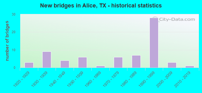
- New bridges - historical statistics
- 31920-1929
- 91930-1939
- 41940-1949
- 61950-1959
- 11960-1969
- 61970-1979
- 71980-1989
- 281990-1999
- 32000-2009
- 12010-2019

- Reconstructed bridges - Historical Statistics
- 41950-1959
- 21960-1969
- 51970-1979
- 41980-1989
- 31990-1999
- 02000-2009
- 12010-2019


- Bridge Condition - Deck
- 88.5%Good
- 11.5%Satisfactory

- Bridge Condition - Superstructure
- 19.2%Very good
- 73.1%Good
- 7.7%Satisfactory

- Bridge Condition - Substructure
- 76.9%Good
- 23.1%Satisfactory

- Bridge Condition - Channel
- 12.3%Very good
- 66.7%Good
- 21.1%Satisfactory

- Bridge Condition - Culverts
- 70.3%Good
- 27.0%Satisfactory
- 2.7%Fair
Find on map >> Show street view
Structure Number: 161260008611028, Location: 0.2 MI S OF SH 44 (Lat: 27.743969, Lng: -98.085417), Route carried "on" structure: Ramp State highway 44, Year Built: 1937, Year Reconstructed: 1983, Status: Open, Structure Length: 2.44m (8.01ft), Average Daily Traffic: 17,560 (year 2013), Truck Traffic: 8%, Average Future Daily Traffic: 24,580 (year 2033), Design Load: H 15, Features Intersected: LATTAS CREEK
Minimum Vertical Clearance: 30+ m (98+ ft), Kilometerpoint: 15.134, Lanes on structure: 3, Owner: State Highway Agency, Approaching Roadway Width: 13.4m (44.0ft), Material/Design: Concrete, Design/Construction: Culvert, Number Of Spans In Main Unit: 14, Length of Maximum Span: 1.5m (4.9ft), Curb-To-Curb Width: 15.5m (50.9ft), Out-to-Out Width: 20.2m (66.3ft)
Condition: Channel: Good, Culverts: Satisfactory, Operating Rating: 32.7 metric tons, Method Used To Determine Operating Rating: Field evaluation and documented engineering judgment, Inventory Rating: 24.5 metric tons, Method Used To Determine Inventory Rating: Field evaluation and documented engineering judgment, Structural Evaluation: Equal to present minimum criteria, Deck Geometry: Superior to present desirable criteria, Waterway Adequacy: Equal to present minimum criteria, Approach Roadway Alignment: Equal to present desirable criteria, Designated Inspection Frequency: Every 24 months, Inspection Date: March 2020
Find on map >> Show street view
Structure Number: 161260008619031, Location: 0.4 MI W OF FM 1930 (Lat: 27.726664, Lng: -97.991314), Route carried "on" structure: State highway 665, Year Built: 1949, Year Reconstructed: 1968, Status: Open, Structure Length: 3.05m (10.01ft), Average Daily Traffic: 4,317 (year 2020), Truck Traffic: 8%, Average Future Daily Traffic: 6,500 (year 2033), Design Load: H 20, Features Intersected: SAN FERNANDO CREEK
Minimum Vertical Clearance: 30+ m (98+ ft), Kilometerpoint: 9.954, Lanes on structure: 2, Owner: State Highway Agency, Approaching Roadway Width: 9.1m (29.9ft), Material/Design: Concrete, Design/Construction: Slab, Number Of Spans In Main Unit: 4, Length of Maximum Span: 7.6m (24.9ft), Curb-To-Curb Width: 10.1m (33.1ft), Out-to-Out Width: 10.8m (35.4ft)
Condition: Deck: Good, Superstructure: Good, Substructure: Satisfactory, Channel: Good, Operating Rating: 58.0 metric tons, Method Used To Determine Operating Rating: Load Factor (LF), Inventory Rating: 34.5 metric tons, Method Used To Determine Inventory Rating: Load Factor (LF), Structural Evaluation: Equal to present minimum criteria, Deck Geometry: Meets minimum limits, Waterway Adequacy: Equal to present minimum criteria, Approach Roadway Alignment: Equal to present desirable criteria, Designated Inspection Frequency: Every 24 months, Inspection Date: Febuary 2020, Deck Structure Type: Concrete Cast-file-Place
Find on map >> Show street view
Structure Number: 161260008619032, Location: 0.4 MI S OF SH44 (Lat: 27.746514, Lng: -98.069894), Route carried "on" structure: State highway 665, Year Built: 1949, Year Reconstructed: 1968, Status: Open, Structure Length: 1.77m (5.81ft), Average Daily Traffic: 6,053 (year 2020), Truck Traffic: 8%, Average Future Daily Traffic: 11,950 (year 2033), Features Intersected: LATTAS CREEK
Minimum Vertical Clearance: 30+ m (98+ ft), Kilometerpoint: 0.319, Lanes on structure: 2, Owner: State Highway Agency, Approaching Roadway Width: 12.8m (42.0ft), Material/Design: Concrete, Design/Construction: Culvert, Number Of Spans In Main Unit: 7, Length of Maximum Span: 3.0m (9.8ft), Curb or Sidewalk Widths: Left: 1.7m (5.6ft), Right: 1.7m (5.6ft), Curb-To-Curb Width: 13.0m (42.7ft), Out-to-Out Width: 17.2m (56.4ft)
Condition: Channel: Good, Culverts: Satisfactory, Operating Rating: 32.7 metric tons, Method Used To Determine Operating Rating: Field evaluation and documented engineering judgment, Inventory Rating: 24.5 metric tons, Method Used To Determine Inventory Rating: Field evaluation and documented engineering judgment, Structural Evaluation: Equal to present minimum criteria, Deck Geometry: Somewhat better than minimum adequacy, Waterway Adequacy: Equal to present minimum criteria, Approach Roadway Alignment: Equal to present desirable criteria, Designated Inspection Frequency: Every 24 months, Inspection Date: March 2020, Deck Structure Type: Concrete Cast-file-Place, Wearing Surface/Protective System: Wearing Surface: Bituminous
Find on map >> Show street view
Structure Number: 161260008619034, Location: 0.1 MI W OF FM 1931 (Lat: 27.729975, Lng: -98.042644), Route carried "on" structure: State highway 665, Year Built: 1952, Year Reconstructed: 2017, Status: Open, Structure Length: 1.52m (4.99ft), Average Daily Traffic: 8,246 (year 2020), Truck Traffic: 8%, Average Future Daily Traffic: 14,110 (year 2033), Design Load: H 15, Features Intersected: LATTAS CREEK
Minimum Vertical Clearance: 30+ m (98+ ft), Kilometerpoint: 4.828, Lanes on structure: 2, Owner: State Highway Agency, Approaching Roadway Width: 11.6m (38.1ft), Skew: 3 degrees, Material/Design: Concrete, Design/Construction: Slab, Number Of Spans In Main Unit: 2, Length of Maximum Span: 7.6m (24.9ft), Curb-To-Curb Width: 12.7m (41.7ft), Out-to-Out Width: 13.6m (44.6ft)
Condition: Deck: Good, Superstructure: Good, Substructure: Good, Channel: Satisfactory, Operating Rating: 32.7 metric tons, Method Used To Determine Operating Rating: Load Factor (LF), Inventory Rating: 20.0 metric tons, Method Used To Determine Inventory Rating: Load Factor (LF), Structural Evaluation: Somewhat better than minimum adequacy, Deck Geometry: Somewhat better than minimum adequacy, Waterway Adequacy: Equal to present minimum criteria, Approach Roadway Alignment: Equal to present desirable criteria, Designated Inspection Frequency: Every 24 months, Inspection Date: Febuary 2020, Deck Structure Type: Concrete Cast-file-Place, Wearing Surface/Protective System: Wearing Surface: Bituminous
Find on map >> Show street view
Structure Number: 161260008701001, Location: 0.2 MI W OF FM 1931 (Lat: 27.760514, Lng: -98.050653), Route carried "on" structure: State highway 44, Year Built: 1925, Year Reconstructed: 1997, Status: Open, Structure Length: 0.67m (2.20ft), Average Daily Traffic: 18,800 (year 2020), Truck Traffic: 8%, Average Future Daily Traffic: 40,960 (year 2033), Design Load: H 15, Features Intersected: DRAIN
Minimum Vertical Clearance: 30+ m (98+ ft), Kilometerpoint: 18.752, Lanes on structure: 5, Owner: State Highway Agency, Approaching Roadway Width: 25.6m (84.0ft), Material/Design: Concrete, Design/Construction: Culvert, Number Of Spans In Main Unit: 4, Length of Maximum Span: 1.5m (4.9ft), Curb or Sidewalk Widths: Left: 1.4m (4.6ft), Right: 1.4m (4.6ft), Curb-To-Curb Width: 25.6m (84.0ft), Out-to-Out Width: 28.8m (94.5ft)
Condition: Channel: Good, Culverts: Good, Operating Rating: 32.7 metric tons, Method Used To Determine Operating Rating: Field evaluation and documented engineering judgment, Inventory Rating: 24.5 metric tons, Method Used To Determine Inventory Rating: Field evaluation and documented engineering judgment, Structural Evaluation: Equal to present minimum criteria, Deck Geometry: Superior to present desirable criteria, Waterway Adequacy: Equal to present minimum criteria, Approach Roadway Alignment: Equal to present desirable criteria, Length Of Structure Improvement: 0.70m (2.30ft), Designated Inspection Frequency: Every 24 months, Inspection Date: March 2020
Find on map >> Show street view
Structure Number: 161260008701002, Location: 0.8 MI E OF FM 1931 (Lat: 27.769906, Lng: -98.037422), Route carried "on" structure: State highway 44, Year Built: 1930, Year Reconstructed: 1959, Status: Open, Structure Length: 2.62m (8.60ft), Average Daily Traffic: 11,005 (year 2020), Truck Traffic: 8%, Average Future Daily Traffic: 20,330 (year 2033), Features Intersected: SAN FERNANDO CRK REL
Minimum Vertical Clearance: 30+ m (98+ ft), Kilometerpoint: 20.411, Lanes on structure: 4, Owner: State Highway Agency, Approaching Roadway Width: 23.2m (76.1ft), Skew: 20 degrees, Material/Design: Concrete, Design/Construction: Culvert, Number Of Spans In Main Unit: 10, Length of Maximum Span: 2.4m (7.9ft), Curb-To-Curb Width: 23.2m (76.1ft), Out-to-Out Width: 35.2m (115.5ft)
Condition: Channel: Good, Culverts: Fair, Operating Rating: 32.7 metric tons, Method Used To Determine Operating Rating: Field evaluation and documented engineering judgment, Inventory Rating: 24.5 metric tons, Method Used To Determine Inventory Rating: Field evaluation and documented engineering judgment, Structural Evaluation: Somewhat better than minimum adequacy, Deck Geometry: Superior to present desirable criteria, Waterway Adequacy: Equal to present minimum criteria, Approach Roadway Alignment: Equal to present desirable criteria, Designated Inspection Frequency: Every 24 months, Inspection Date: Febuary 2020, Deck Structure Type: Concrete Cast-file-Place, Wearing Surface/Protective System: Wearing Surface: Bituminous
Find on map >> Show street view
Structure Number: 161260008701004, Location: 1.3 MI E OF FM 1931 (Lat: 27.773708, Lng: -98.032000), Route carried "on" structure: State highway 44, Year Built: 1925, Year Reconstructed: 1959, Status: Open, Structure Length: 1.19m (3.90ft), Average Daily Traffic: 11,005 (year 2020), Truck Traffic: 8%, Average Future Daily Traffic: 20,330 (year 2033), Features Intersected: SAN FERNANDO CR REL
Minimum Vertical Clearance: 30+ m (98+ ft), Kilometerpoint: 21.061, Lanes on structure: 4, Owner: State Highway Agency, Approaching Roadway Width: 23.2m (76.1ft), Skew: 20 degrees, Material/Design: Concrete, Design/Construction: Culvert, Number Of Spans In Main Unit: 7, Length of Maximum Span: 1.5m (4.9ft)
Condition: Channel: Good, Culverts: Good, Operating Rating: 32.7 metric tons, Method Used To Determine Operating Rating: Field evaluation and documented engineering judgment, Inventory Rating: 24.5 metric tons, Method Used To Determine Inventory Rating: Field evaluation and documented engineering judgment, Structural Evaluation: Equal to present minimum criteria, Waterway Adequacy: Equal to present minimum criteria, Approach Roadway Alignment: Equal to present desirable criteria, Designated Inspection Frequency: Every 24 months, Inspection Date: Febuary 2020
Find on map >> Show street view
Structure Number: 161260008701026, Location: 1.2 MI E OF FM 1931 (Lat: 27.772631, Lng: -98.033689), Route carried "on" structure: State highway 44, Year Built: 1959, Year Reconstructed: 1989, Status: Open, Structure Length: 12.19m (39.99ft), Average Daily Traffic: 5,561 (year 2020), Truck Traffic: 8%, Average Future Daily Traffic: 10,160 (year 2033), Design Load: H 20, Features Intersected: SAN FERNANDO CREEK
Minimum Vertical Clearance: 30+ m (98+ ft), Kilometerpoint: 20.836, Lanes on structure: 2, Owner: State Highway Agency, Approaching Roadway Width: 11.6m (38.1ft), Material/Design: Concrete, Design/Construction: Stringer/Multi-beam, Number Of Spans In Main Unit: 10, Length of Maximum Span: 12.2m (40.0ft), Curb-To-Curb Width: 11.3m (37.1ft), Out-to-Out Width: 12.3m (40.4ft)
Condition: Deck: Good, Superstructure: Good, Substructure: Satisfactory, Channel: Good, Operating Rating: 42.6 metric tons, Method Used To Determine Operating Rating: Load Factor (LF), Inventory Rating: 25.4 metric tons, Method Used To Determine Inventory Rating: Load Factor (LF), Structural Evaluation: Equal to present minimum criteria, Deck Geometry: Equal to present minimum criteria, Waterway Adequacy: Equal to present minimum criteria, Approach Roadway Alignment: Equal to present desirable criteria, Designated Inspection Frequency: Every 24 months, Inspection Date: Febuary 2020, Deck Structure Type: Concrete Cast-file-Place, Wearing Surface/Protective System: Wearing Surface: Bituminous
Find on map >> Show street view
Structure Number: 161260008701028, Location: 1.2 MI E OF FM 1931 (Lat: 27.772478, Lng: -98.033514), Route carried "on" structure: State highway 44, Year Built: 1989, Status: Open, Structure Length: 12.19m (39.99ft), Average Daily Traffic: 5,443 (year 2020), Truck Traffic: 8%, Average Future Daily Traffic: 10,160 (year 2033), Design Load: HS 20, Features Intersected: SAN FERNANDO CREEK
Minimum Vertical Clearance: 30+ m (98+ ft), Kilometerpoint: 20.839, Lanes on structure: 2, Owner: State Highway Agency, Approaching Roadway Width: 11.6m (38.1ft), Material/Design: Prestressed concrete, Number Of Spans In Main Unit: 10, Length of Maximum Span: 15.2m (49.9ft), Curb-To-Curb Width: 11.3m (37.1ft), Out-to-Out Width: 12.2m (40.0ft)
Condition: Deck: Good, Superstructure: Good, Substructure: Good, Channel: Good, Operating Rating: 54.4 metric tons, Method Used To Determine Operating Rating: Assigned rating based on Load Factor Design (LFD) reported in metric tons, Inventory Rating: 32.7 metric tons, Method Used To Determine Inventory Rating: Assigned rating based on Load Factor Design (LFD) reported in metric tons, Structural Evaluation: Better than present minimum criteria, Deck Geometry: Equal to present minimum criteria, Waterway Adequacy: Equal to present minimum criteria, Approach Roadway Alignment: Equal to present desirable criteria, Designated Inspection Frequency: Every 24 months, Inspection Date: Febuary 2020, Deck Structure Type: Other, Wearing Surface/Protective System: Wearing Surface: Bituminous
Find on map >> Show street view
Structure Number: 161260025403025, Location: 1.6 MI N OF BUS 281 (Lat: 27.810025, Lng: -98.083528), Route carried "on" structure: US 281, Year Built: 1931, Year Reconstructed: 1955, Status: Open, Structure Length: 5.27m (17.29ft), Average Daily Traffic: 5,149 (year 2020), Truck Traffic: 34%, Average Future Daily Traffic: 4,970 (year 2033), Design Load: H 15, Features Intersected: CHILTIPIN CREEK
Minimum Vertical Clearance: 30+ m (98+ ft), Kilometerpoint: 27.417, Lanes on structure: 2, Owner: State Highway Agency, Approaching Roadway Width: 11.6m (38.1ft), Material/Design: Concrete, Design/Construction: Tee Beam, Number Of Spans In Main Unit: 5, Length of Maximum Span: 10.7m (35.1ft), Curb-To-Curb Width: 12.0m (39.4ft), Out-to-Out Width: 13.0m (42.7ft)
Condition: Deck: Good, Superstructure: Good, Substructure: Good, Channel: Good, Operating Rating: 39.0 metric tons, Method Used To Determine Operating Rating: Load Factor (LF), Inventory Rating: 23.6 metric tons, Method Used To Determine Inventory Rating: Load Factor (LF), Structural Evaluation: Somewhat better than minimum adequacy, Deck Geometry: Better than present minimum criteria, Waterway Adequacy: Superior to present desirable criteria, Approach Roadway Alignment: Equal to present desirable criteria, Length Of Structure Improvement: 5.27m (17.29ft), Designated Inspection Frequency: Every 24 months, Inspection Date: Febuary 2020, Bridge Improvement Cost: $137,000, Roadway Improvement Cost: $34,000, Total Project Cost: $171,000, Deck Structure Type: Concrete Cast-file-Place, Wearing Surface/Protective System: Wearing Surface: Bituminous
Find on map >> Show street view
Structure Number: 161260025403026, Location: 1.5 MI N JCT BUS 281 (Lat: 27.808697, Lng: -98.083825), Route carried "on" structure: US 281, Year Built: 1931, Year Reconstructed: 1993, Status: Open, Structure Length: 1.62m (5.31ft), Average Daily Traffic: 9,525 (year 2020), Truck Traffic: 34%, Average Future Daily Traffic: 9,940 (year 2033), Features Intersected: CHILTIPIN CREEK RELIEF
Minimum Vertical Clearance: 30+ m (98+ ft), Kilometerpoint: 27.613, Lanes on structure: 4, Owner: State Highway Agency, Approaching Roadway Width: 23.2m (76.1ft), Skew: 20 degrees, Material/Design: Concrete, Design/Construction: Culvert, Number Of Spans In Main Unit: 6, Length of Maximum Span: 2.4m (7.9ft)
Condition: Channel: Good, Culverts: Satisfactory, Operating Rating: 32.7 metric tons, Method Used To Determine Operating Rating: Field evaluation and documented engineering judgment, Inventory Rating: 24.5 metric tons, Method Used To Determine Inventory Rating: Field evaluation and documented engineering judgment, Structural Evaluation: Equal to present minimum criteria, Waterway Adequacy: Superior to present desirable criteria, Approach Roadway Alignment: Equal to present desirable criteria, Designated Inspection Frequency: Every 24 months, Inspection Date: Febuary 2020
Find on map >> Show street view
Structure Number: 161260025403029, Location: 0.8 MI N OF FM 3376 (Lat: 27.787911, Lng: -98.083364), Route carried "on" structure: Business State highway 281, Year Built: 1931, Year Reconstructed: 1999, Status: Open, Structure Length: 0.88m (2.89ft), Average Daily Traffic: 6,900 (year 2010), Truck Traffic: 24%, Average Future Daily Traffic: 9,660 (year 2028), Features Intersected: DRAIN
Minimum Vertical Clearance: 30+ m (98+ ft), Kilometerpoint: 29.934, Lanes on structure: 3, Owner: State Highway Agency, Approaching Roadway Width: 21.9m (71.9ft), Material/Design: Concrete, Design/Construction: Culvert, Number Of Spans In Main Unit: 5, Length of Maximum Span: 1.5m (4.9ft), Curb-To-Curb Width: 21.8m (71.5ft), Out-to-Out Width: 22.6m (74.1ft)
Condition: Channel: Very good, Culverts: Satisfactory, Operating Rating: 32.7 metric tons, Method Used To Determine Operating Rating: Field evaluation and documented engineering judgment, Inventory Rating: 24.5 metric tons, Method Used To Determine Inventory Rating: Field evaluation and documented engineering judgment, Structural Evaluation: Equal to present minimum criteria, Deck Geometry: Superior to present desirable criteria, Waterway Adequacy: Equal to present minimum criteria, Approach Roadway Alignment: Equal to present desirable criteria, Designated Inspection Frequency: Every 24 months, Inspection Date: Febuary 2020, Deck Structure Type: Concrete Cast-file-Place, Wearing Surface/Protective System: Wearing Surface: Bituminous
Find on map >> Show street view
Structure Number: 16126002540303, Location: 0.3 MI N OF FM 3376 (Lat: 27.778508, Lng: -98.083083), Route carried "on" structure: Business State highway 281, Year Built: 1931, Year Reconstructed: 1998, Status: Open, Structure Length: 2.10m (6.89ft), Average Daily Traffic: 3,551 (year 2020), Truck Traffic: 4%, Average Future Daily Traffic: 8,490 (year 2033), Features Intersected: DRAIN
Minimum Vertical Clearance: 30+ m (98+ ft), Kilometerpoint: 34.916, Lanes on structure: 4, Owner: State Highway Agency, Approaching Roadway Width: 23.8m (78.1ft), Material/Design: Concrete, Design/Construction: Culvert, Number Of Spans In Main Unit: 10, Length of Maximum Span: 2.7m (8.9ft)
Condition: Channel: Good, Culverts: Satisfactory, Operating Rating: 39.9 metric tons, Method Used To Determine Operating Rating: Load Factor (LF), Inventory Rating: 23.6 metric tons, Method Used To Determine Inventory Rating: Load Factor (LF), Structural Evaluation: Equal to present minimum criteria, Waterway Adequacy: Equal to present minimum criteria, Approach Roadway Alignment: Equal to present desirable criteria, Designated Inspection Frequency: Every 24 months, Inspection Date: Febuary 2020
Find on map >> Show street view
Structure Number: 161260025403032, Location: BUS 281 @ SH 44 (Lat: 27.747461, Lng: -98.083917), Route carried "on" structure: Business US 281, Year Built: 1937, Year Reconstructed: 1983, Status: Open, Structure Length: 23.84m (78.22ft), Average Daily Traffic: 6,519 (year 2020), Truck Traffic: 5%, Average Future Daily Traffic: 17,980 (year 2038), Design Load: H 15, Features Intersected: SH 44 & TEX-MEX RR
Minimum Vertical Clearance: 30+ m (98+ ft), Kilometerpoint: 38.272, Lanes on structure: 4, Lanes under structure: 5, Owner: State Highway Agency, Approaching Roadway Width: 17.1m (56.1ft), Skew: 39 degrees, Material/Design: Prestressed concrete, Design/Construction: Stringer/Multi-beam, Number Of Spans In Main Unit: 1, Number Of Approach Spans: 12, Length of Maximum Span: 27.4m (89.9ft), Curb or Sidewalk Widths: Left: 0.0m, Right: 1.5m (4.9ft), Curb-To-Curb Width: 17.1m (56.1ft), Out-to-Out Width: 20.5m (67.3ft)
Condition: Deck: Satisfactory, Superstructure: Satisfactory, Substructure: Satisfactory, Operating Rating: 50.8 metric tons, Method Used To Determine Operating Rating: Load Factor (LF), Inventory Rating: 29.9 metric tons, Method Used To Determine Inventory Rating: Load Factor (LF), Structural Evaluation: Equal to present minimum criteria, Deck Geometry: Somewhat better than minimum adequacy, Underclear: High priority of corrective action, Approach Roadway Alignment: Equal to present desirable criteria, Designated Inspection Frequency: Every 24 months, Inspection Date: Febuary 2020, Deck Structure Type: Corrugated Steel, Wearing Surface/Protective System: Wearing Surface: Monolithic Concrete
Find on map >> Show street view
Structure Number: 161260025403033, Location: 0.2 MI S OF SH 44 (Lat: 27.744350, Lng: -98.084972), Route carried "on" structure: Business State highway 281, Year Built: 1937, Year Reconstructed: 1983, Status: Open, Structure Length: 2.40m (7.87ft), Average Daily Traffic: 6,210 (year 2013), Truck Traffic: 1%, Average Future Daily Traffic: 8,690 (year 2033), Design Load: H 15, Features Intersected: LATTAS CREEK
Minimum Vertical Clearance: 30+ m (98+ ft), Kilometerpoint: 38.695, Lanes on structure: 4, Owner: State Highway Agency, Approaching Roadway Width: 17.1m (56.1ft), Skew: 30 degrees, Material/Design: Concrete, Design/Construction: Culvert, Number Of Spans In Main Unit: 14, Length of Maximum Span: 1.5m (4.9ft), Curb or Sidewalk Widths: Left: 0.0m, Right: 1.8m (5.9ft), Curb-To-Curb Width: 18.7m (61.4ft), Out-to-Out Width: 22.3m (73.2ft)
Condition: Channel: Satisfactory, Culverts: Good, Operating Rating: 32.7 metric tons, Method Used To Determine Operating Rating: Field evaluation and documented engineering judgment, Inventory Rating: 24.5 metric tons, Method Used To Determine Inventory Rating: Field evaluation and documented engineering judgment, Structural Evaluation: Equal to present minimum criteria, Deck Geometry: Equal to present minimum criteria, Waterway Adequacy: Equal to present minimum criteria, Approach Roadway Alignment: Equal to present desirable criteria, Length Of Structure Improvement: 2.38m (7.81ft), Designated Inspection Frequency: Every 24 months, Inspection Date: March 2020, Bridge Improvement Cost: $49,000, Roadway Improvement Cost: $12,000, Total Project Cost: $61,000
Find on map >> Show street view
Structure Number: 161260025403039, Location: 1.7 MI N JCT BUS 281 (Lat: 27.812653, Lng: -98.083125), Route carried "on" structure: US 281, Year Built: 1955, Year Reconstructed: 1993, Status: Open, Structure Length: 1.16m (3.81ft), Average Daily Traffic: 9,525 (year 2020), Truck Traffic: 34%, Average Future Daily Traffic: 9,940 (year 2033), Features Intersected: DRAW
Minimum Vertical Clearance: 30+ m (98+ ft), Kilometerpoint: 27.137, Lanes on structure: 4, Owner: State Highway Agency, Approaching Roadway Width: 23.2m (76.1ft), Skew: 23 degrees, Material/Design: Concrete, Design/Construction: Culvert, Number Of Spans In Main Unit: 3, Length of Maximum Span: 3.7m (12.1ft)
Condition: Channel: Good, Culverts: Satisfactory, Operating Rating: 32.7 metric tons, Method Used To Determine Operating Rating: Field evaluation and documented engineering judgment, Inventory Rating: 24.5 metric tons, Method Used To Determine Inventory Rating: Field evaluation and documented engineering judgment, Structural Evaluation: Equal to present minimum criteria, Waterway Adequacy: Equal to present minimum criteria, Approach Roadway Alignment: Equal to present desirable criteria, Designated Inspection Frequency: Every 24 months, Inspection Date: Febuary 2020
Find on map >> Show street view
Structure Number: 161260025403061, Location: 1.6 MI N OF BUS 281 (Lat: 27.810419, Lng: -98.084003), Route carried "on" structure: US 281, Year Built: 1994, Status: Open, Structure Length: 12.19m (39.99ft), Average Daily Traffic: 4,376 (year 2020), Truck Traffic: 34%, Average Future Daily Traffic: 4,970 (year 2033), Design Load: HS 20, Features Intersected: CHILTIPIN CREEK
Minimum Vertical Clearance: 30+ m (98+ ft), Kilometerpoint: 27.417, Lanes on structure: 2, Owner: State Highway Agency, Approaching Roadway Width: 11.6m (38.1ft), Material/Design: Prestressed concrete, Design/Construction: Stringer/Multi-beam, Number Of Spans In Main Unit: 5, Length of Maximum Span: 24.4m (80.1ft), Curb-To-Curb Width: 11.7m (38.4ft), Out-to-Out Width: 12.2m (40.0ft)
Condition: Deck: Good, Superstructure: Very good, Substructure: Good, Channel: Good, Operating Rating: 54.4 metric tons, Method Used To Determine Operating Rating: Assigned rating based on Load Factor Design (LFD) reported in metric tons, Inventory Rating: 32.7 metric tons, Method Used To Determine Inventory Rating: Assigned rating based on Load Factor Design (LFD) reported in metric tons, Structural Evaluation: Better than present minimum criteria, Deck Geometry: Better than present minimum criteria, Waterway Adequacy: Superior to present desirable criteria, Approach Roadway Alignment: Equal to present desirable criteria, Designated Inspection Frequency: Every 24 months, Inspection Date: Febuary 2020, Deck Structure Type: Concrete Precast Panels, Wearing Surface/Protective System: Wearing Surface: Bituminous
Find on map >> Show street view
Structure Number: 161260025403075, Location: 1.3 MI S OF FM 3376 (Lat: 27.762356, Lng: -98.082525), Route carried "on" structure: State highway 281, Year Built: 1998, Status: Open, Structure Length: 5.94m (19.49ft), Average Daily Traffic: 5,106 (year 2020), Truck Traffic: 1%, Average Future Daily Traffic: 10,020 (year 2033), Design Load: HS 20, Features Intersected: SAN DIEGO CREEK
Minimum Vertical Clearance: 30+ m (98+ ft), Kilometerpoint: 36.650, Lanes on structure: 5, Owner: State Highway Agency, Approaching Roadway Width: 19.8m (65.0ft), Material/Design: Prestressed concrete, Design/Construction: Box Beam or Girders - Multiple, Number Of Spans In Main Unit: 5, Length of Maximum Span: 13.7m (44.9ft), Curb or Sidewalk Widths: Left: 1.6m (5.2ft), Right: 1.6m (5.2ft), Curb-To-Curb Width: 19.8m (65.0ft), Out-to-Out Width: 24.1m (79.1ft)
Condition: Deck: Good, Superstructure: Good, Substructure: Good, Channel: Good, Operating Rating: 54.4 metric tons, Method Used To Determine Operating Rating: Assigned rating based on Load Factor Design (LFD) reported in metric tons, Inventory Rating: 32.7 metric tons, Method Used To Determine Inventory Rating: Assigned rating based on Load Factor Design (LFD) reported in metric tons, Structural Evaluation: Better than present minimum criteria, Deck Geometry: Meets minimum limits, Waterway Adequacy: Superior to present desirable criteria, Approach Roadway Alignment: Equal to present desirable criteria, Designated Inspection Frequency: Every 24 months, Inspection Date: Febuary 2020, Deck Structure Type: Concrete Cast-file-Place
Find on map >> Show street view
Structure Number: 161260025403076, Location: 0.5 MI N OF BUS 281 (Lat: 27.799656, Lng: -98.084408), Route carried "on" structure: ServiceUS 281, Year Built: 1999, Status: Open, Structure Length: 1.19m (3.90ft), Average Daily Traffic: 3,600 (year 2016), Truck Traffic: 6%, Average Future Daily Traffic: 11,860 (year 2038), Design Load: HS 20, Features Intersected: DRAW
Minimum Vertical Clearance: 30+ m (98+ ft), Kilometerpoint: 32.533, Lanes on structure: 2, Owner: State Highway Agency, Approaching Roadway Width: 11.6m (38.1ft), Material/Design: Concrete, Design/Construction: Culvert, Number Of Spans In Main Unit: 4, Length of Maximum Span: 2.4m (7.9ft), Curb-To-Curb Width: 11.6m (38.1ft), Out-to-Out Width: 12.3m (40.4ft)
Condition: Channel: Very good, Culverts: Good, Operating Rating: 39.9 metric tons, Method Used To Determine Operating Rating: Load Factor (LF), Inventory Rating: 23.6 metric tons, Method Used To Determine Inventory Rating: Load Factor (LF), Structural Evaluation: Equal to present minimum criteria, Deck Geometry: Better than present minimum criteria, Waterway Adequacy: Better than present minimum criteria, Approach Roadway Alignment: Equal to present desirable criteria, Designated Inspection Frequency: Every 48 months, Inspection Date: Febuary 2020, Deck Structure Type: Concrete Cast-file-Place, Wearing Surface/Protective System: Wearing Surface: Bituminous
Find on map >> Show street view
Structure Number: 161260025403079, Location: 1.4 MI N OF FM 3376 (Lat: 27.796431, Lng: -98.084931), Route carried "on" structure: Business State highway 281, Year Built: 1999, Status: Open, Structure Length: 1.74m (5.71ft), Average Daily Traffic: 2,380 (year 2013), Truck Traffic: 3%, Average Future Daily Traffic: 3,340 (year 2033), Design Load: HS 20, Features Intersected: DRAW
Minimum Vertical Clearance: 30+ m (98+ ft), Kilometerpoint: 32.892, Lanes on structure: 2, Owner: State Highway Agency, Approaching Roadway Width: 11.6m (38.1ft), Skew: 1 degrees, Material/Design: Concrete, Design/Construction: Culvert, Number Of Spans In Main Unit: 5, Length of Maximum Span: 2.7m (8.9ft), Curb-To-Curb Width: 12.5m (41.0ft), Out-to-Out Width: 14.6m (47.9ft)
Condition: Channel: Good, Culverts: Good, Operating Rating: 39.9 metric tons, Method Used To Determine Operating Rating: Load Factor (LF), Inventory Rating: 23.6 metric tons, Method Used To Determine Inventory Rating: Load Factor (LF), Structural Evaluation: Equal to present minimum criteria, Deck Geometry: Better than present minimum criteria, Waterway Adequacy: Equal to present minimum criteria, Approach Roadway Alignment: Equal to present desirable criteria, Designated Inspection Frequency: Every 48 months, Inspection Date: Febuary 2020, Deck Structure Type: Concrete Cast-file-Place, Wearing Surface/Protective System: Wearing Surface: Bituminous
Find on map >> Show street view
Structure Number: 16126002540308, Location: 1.4 MI N OF FM 3376 (Lat: 27.796483, Lng: -98.084603), Route carried "on" structure: Business State highway 281, Year Built: 1999, Status: Open, Structure Length: 1.65m (5.41ft), Average Daily Traffic: 2,380 (year 2013), Truck Traffic: 3%, Average Future Daily Traffic: 3,340 (year 2033), Design Load: HS 20, Features Intersected: DRAW
Minimum Vertical Clearance: 30+ m (98+ ft), Kilometerpoint: 32.893, Lanes on structure: 1, Owner: State Highway Agency, Approaching Roadway Width: 7.9m (25.9ft), Material/Design: Concrete, Design/Construction: Culvert, Number Of Spans In Main Unit: 5, Length of Maximum Span: 2.7m (8.9ft), Curb-To-Curb Width: 9.2m (30.2ft), Out-to-Out Width: 9.9m (32.5ft)
Condition: Channel: Good, Culverts: Good, Operating Rating: 32.7 metric tons, Method Used To Determine Operating Rating: Field evaluation and documented engineering judgment, Inventory Rating: 24.5 metric tons, Method Used To Determine Inventory Rating: Field evaluation and documented engineering judgment, Structural Evaluation: Equal to present minimum criteria, Deck Geometry: Meets minimum limits, Waterway Adequacy: Equal to present minimum criteria, Approach Roadway Alignment: Equal to present desirable criteria, Designated Inspection Frequency: Every 24 months, Inspection Date: Febuary 2020, Deck Structure Type: Concrete Cast-file-Place, Wearing Surface/Protective System: Wearing Surface: Bituminous
Find on map >> Show street view
Structure Number: 161260025407077, Location: 0.5 MI N OF BUS 281 (Lat: 27.799647, Lng: -98.083572), Route carried "on" structure: US 281, Year Built: 1999, Status: Open, Structure Length: 1.16m (3.81ft), Average Daily Traffic: 4,376 (year 2020), Truck Traffic: 34%, Average Future Daily Traffic: 4,970 (year 2033), Design Load: HS 20, Features Intersected: DRAW
Minimum Vertical Clearance: 30+ m (98+ ft), Kilometerpoint: 0.607, Lanes on structure: 2, Owner: State Highway Agency, Approaching Roadway Width: 11.6m (38.1ft), Material/Design: Concrete, Design/Construction: Culvert, Number Of Spans In Main Unit: 4, Length of Maximum Span: 2.4m (7.9ft), Curb-To-Curb Width: 11.7m (38.4ft), Out-to-Out Width: 12.5m (41.0ft)
Condition: Channel: Very good, Culverts: Good, Operating Rating: 32.7 metric tons, Method Used To Determine Operating Rating: Field evaluation and documented engineering judgment, Inventory Rating: 24.5 metric tons, Method Used To Determine Inventory Rating: Field evaluation and documented engineering judgment, Structural Evaluation: Equal to present minimum criteria, Deck Geometry: Better than present minimum criteria, Waterway Adequacy: Equal to present minimum criteria, Approach Roadway Alignment: Equal to present desirable criteria, Designated Inspection Frequency: Every 24 months, Inspection Date: April 2020
Find on map >> Show street view
Structure Number: 161260025407078, Location: 0.5 MI N OF BUS 281 (Lat: 27.799714, Lng: -98.083203), Route carried "on" structure: US 281, Year Built: 1999, Status: Open, Structure Length: 1.19m (3.90ft), Average Daily Traffic: 5,149 (year 2020), Truck Traffic: 34%, Average Future Daily Traffic: 4,970 (year 2033), Design Load: HS 20, Features Intersected: DRAW
Minimum Vertical Clearance: 30+ m (98+ ft), Kilometerpoint: 0.607, Lanes on structure: 3, Owner: State Highway Agency, Approaching Roadway Width: 11.6m (38.1ft), Material/Design: Concrete, Design/Construction: Culvert, Number Of Spans In Main Unit: 4, Length of Maximum Span: 2.4m (7.9ft), Curb-To-Curb Width: 17.5m (57.4ft), Out-to-Out Width: 18.2m (59.7ft)
Condition: Channel: Good, Culverts: Good, Operating Rating: 32.7 metric tons, Method Used To Determine Operating Rating: Field evaluation and documented engineering judgment, Inventory Rating: 24.5 metric tons, Method Used To Determine Inventory Rating: Field evaluation and documented engineering judgment, Structural Evaluation: Equal to present minimum criteria, Deck Geometry: Superior to present desirable criteria, Waterway Adequacy: Equal to present minimum criteria, Approach Roadway Alignment: Equal to present desirable criteria, Designated Inspection Frequency: Every 24 months, Inspection Date: April 2020
Find on map >> Show street view
Structure Number: 161260025407081, Location: 0.3 MI N OF BUS 281 (Lat: 27.796506, Lng: -98.083328), Route carried "on" structure: US 281, Year Built: 1999, Status: Open, Structure Length: 2.59m (8.50ft), Average Daily Traffic: 4,376 (year 2020), Truck Traffic: 34%, Average Future Daily Traffic: 4,970 (year 2033), Design Load: HS 20, Features Intersected: DRAW
Minimum Vertical Clearance: 30+ m (98+ ft), Kilometerpoint: 0.953, Lanes on structure: 2, Owner: State Highway Agency, Approaching Roadway Width: 11.6m (38.1ft), Skew: 4 degrees, Material/Design: Concrete, Design/Construction: Culvert, Number Of Spans In Main Unit: 5, Length of Maximum Span: 3.0m (9.8ft)
Condition: Channel: Satisfactory, Culverts: Good, Operating Rating: 32.7 metric tons, Method Used To Determine Operating Rating: Field evaluation and documented engineering judgment, Inventory Rating: 24.5 metric tons, Method Used To Determine Inventory Rating: Field evaluation and documented engineering judgment, Structural Evaluation: Equal to present minimum criteria, Waterway Adequacy: Equal to present minimum criteria, Approach Roadway Alignment: Equal to present desirable criteria, Designated Inspection Frequency: Every 24 months, Inspection Date: April 2020
Find on map >> Show street view
Structure Number: 161260025407082, Location: 0.3 MI N OF BUS 281 (Lat: 27.796786, Lng: -98.082989), Route carried "on" structure: US 281, Year Built: 1999, Status: Open, Structure Length: 2.59m (8.50ft), Average Daily Traffic: 5,149 (year 2020), Truck Traffic: 34%, Average Future Daily Traffic: 4,970 (year 2033), Design Load: HS 20, Features Intersected: DRAW
Minimum Vertical Clearance: 30+ m (98+ ft), Kilometerpoint: 0.956, Lanes on structure: 2, Owner: State Highway Agency, Approaching Roadway Width: 11.6m (38.1ft), Skew: 4 degrees, Material/Design: Concrete, Design/Construction: Culvert, Number Of Spans In Main Unit: 5, Length of Maximum Span: 3.0m (9.8ft)
Condition: Channel: Satisfactory, Culverts: Good, Operating Rating: 32.7 metric tons, Method Used To Determine Operating Rating: Field evaluation and documented engineering judgment, Inventory Rating: 24.5 metric tons, Method Used To Determine Inventory Rating: Field evaluation and documented engineering judgment, Structural Evaluation: Equal to present minimum criteria, Waterway Adequacy: Equal to present minimum criteria, Approach Roadway Alignment: Equal to present desirable criteria, Designated Inspection Frequency: Every 24 months, Inspection Date: April 2020
Find on map >> Show street view
Structure Number: 161260025407083, Location: 0.3 MI N OF BUS 281 (Lat: 27.797328, Lng: -98.082564), Route carried "on" structure: ServiceUS 281, Year Built: 1999, Status: Open, Structure Length: 2.59m (8.50ft), Average Daily Traffic: 1,050 (year 2010), Truck Traffic: 3%, Average Future Daily Traffic: 140 (year 2030), Design Load: HS 20, Features Intersected: DRAW
Minimum Vertical Clearance: 30+ m (98+ ft), Kilometerpoint: 0.869, Lanes on structure: 2, Owner: State Highway Agency, Approaching Roadway Width: 11.6m (38.1ft), Skew: 4 degrees, Material/Design: Concrete, Design/Construction: Culvert, Number Of Spans In Main Unit: 5, Length of Maximum Span: 3.0m (9.8ft), Curb-To-Curb Width: 11.5m (37.7ft), Out-to-Out Width: 14.3m (46.9ft)
Condition: Channel: Satisfactory, Culverts: Good, Operating Rating: 32.7 metric tons, Method Used To Determine Operating Rating: Field evaluation and documented engineering judgment, Inventory Rating: 24.5 metric tons, Method Used To Determine Inventory Rating: Field evaluation and documented engineering judgment, Structural Evaluation: Equal to present minimum criteria, Deck Geometry: Equal to present minimum criteria, Waterway Adequacy: Superior to present desirable criteria, Approach Roadway Alignment: Equal to present desirable criteria, Designated Inspection Frequency: Every 24 months, Inspection Date: April 2020
Find on map >> Show street view
Structure Number: 161260025407084, Location: 1.0 MI SW OF BUS 281 (Lat: 27.782306, Lng: -98.093058), Route carried "on" structure: US 281, Year Built: 1999, Status: Open, Structure Length: 0.76m (2.49ft), Average Daily Traffic: 3,663 (year 2019), Truck Traffic: 34%, Average Future Daily Traffic: 6,800 (year 2033), Design Load: HS 20, Features Intersected: DRAW
Minimum Vertical Clearance: 30+ m (98+ ft), Kilometerpoint: 2.824, Lanes on structure: 2, Owner: State Highway Agency, Approaching Roadway Width: 11.6m (38.1ft), Skew: 1 degrees, Material/Design: Concrete, Design/Construction: Culvert, Number Of Spans In Main Unit: 2, Length of Maximum Span: 3.0m (9.8ft)
Condition: Channel: Satisfactory, Culverts: Good, Operating Rating: 32.7 metric tons, Method Used To Determine Operating Rating: Field evaluation and documented engineering judgment, Inventory Rating: 24.5 metric tons, Method Used To Determine Inventory Rating: Field evaluation and documented engineering judgment, Structural Evaluation: Equal to present minimum criteria, Waterway Adequacy: Superior to present desirable criteria, Approach Roadway Alignment: Equal to present desirable criteria, Designated Inspection Frequency: Every 24 months, Inspection Date: April 2020
Find on map >> Show street view
Structure Number: 161260025407085, Location: 1.0 MI SW OF BUS 281 (Lat: 27.782033, Lng: -98.092231), Route carried "on" structure: US 281, Year Built: 1999, Status: Open, Structure Length: 0.76m (2.49ft), Average Daily Traffic: 4,083 (year 2019), Truck Traffic: 34%, Average Future Daily Traffic: 6,800 (year 2033), Design Load: HS 20, Features Intersected: DRAW
Minimum Vertical Clearance: 30+ m (98+ ft), Kilometerpoint: 2.808, Lanes on structure: 2, Owner: State Highway Agency, Approaching Roadway Width: 11.6m (38.1ft), Skew: 1 degrees, Material/Design: Concrete, Design/Construction: Culvert, Number Of Spans In Main Unit: 2, Length of Maximum Span: 3.0m (9.8ft)
Condition: Channel: Satisfactory, Culverts: Good, Operating Rating: 32.7 metric tons, Method Used To Determine Operating Rating: Field evaluation and documented engineering judgment, Inventory Rating: 24.5 metric tons, Method Used To Determine Inventory Rating: Field evaluation and documented engineering judgment, Structural Evaluation: Equal to present minimum criteria, Waterway Adequacy: Superior to present desirable criteria, Approach Roadway Alignment: Equal to present desirable criteria, Designated Inspection Frequency: Every 24 months, Inspection Date: April 2020
Find on map >> Show street view
Structure Number: 161260025407086, Location: US 281 NB AT CR 116 (Lat: 27.768750, Lng: -98.103028), Route carried "on" structure: County highway 116, Year Built: 1999, Status: Open, Structure Length: 1.34m (4.40ft), Average Daily Traffic: 1,000 (year 2010), Truck Traffic: 10%, Average Future Daily Traffic: 1,500 (year 2030), Design Load: HS 20, Features Intersected: OVERFLOW DITCH
Minimum Vertical Clearance: 30+ m (98+ ft), Kilometerpoint: 46.133, Lanes on structure: 3, Owner: State Highway Agency, Approaching Roadway Width: 17.7m (58.1ft), Skew: 3 degrees, Material/Design: Concrete, Design/Construction: Culvert, Number Of Spans In Main Unit: 3, Length of Maximum Span: 3.0m (9.8ft)
Condition: Channel: Good, Culverts: Good, Operating Rating: 32.7 metric tons, Method Used To Determine Operating Rating: Field evaluation and documented engineering judgment, Inventory Rating: 24.5 metric tons, Method Used To Determine Inventory Rating: Field evaluation and documented engineering judgment, Structural Evaluation: Equal to present minimum criteria, Waterway Adequacy: Superior to present desirable criteria, Approach Roadway Alignment: Equal to present desirable criteria, Designated Inspection Frequency: Every 24 months, Inspection Date: April 2020
Find on map >> Show street view
Structure Number: 161260025407087, Location: 1.2 MI N OF SH 44 (Lat: 27.765489, Lng: -98.105283), Route carried "on" structure: US 281, Year Built: 1999, Status: Open, Structure Length: 1.43m (4.69ft), Average Daily Traffic: 6,583 (year 2020), Truck Traffic: 34%, Average Future Daily Traffic: 6,800 (year 2033), Design Load: HS 20, Features Intersected: DRAW
Minimum Vertical Clearance: 30+ m (98+ ft), Kilometerpoint: 5.037, Lanes on structure: 2, Owner: State Highway Agency, Approaching Roadway Width: 11.6m (38.1ft), Material/Design: Concrete, Design/Construction: Culvert, Number Of Spans In Main Unit: 4, Length of Maximum Span: 3.0m (9.8ft), Curb-To-Curb Width: 11.8m (38.7ft), Out-to-Out Width: 12.5m (41.0ft)
Condition: Channel: Good, Culverts: Good, Operating Rating: 32.7 metric tons, Method Used To Determine Operating Rating: Field evaluation and documented engineering judgment, Inventory Rating: 24.5 metric tons, Method Used To Determine Inventory Rating: Field evaluation and documented engineering judgment, Structural Evaluation: Equal to present minimum criteria, Deck Geometry: Better than present minimum criteria, Waterway Adequacy: Equal to present minimum criteria, Approach Roadway Alignment: Equal to present desirable criteria, Designated Inspection Frequency: Every 24 months, Inspection Date: April 2020
Find on map >> Show street view
Structure Number: 161260025407088, Location: 1.1 MI N OF SH 44 (Lat: 27.765058, Lng: -98.105733), Route carried "on" structure: US 281, Year Built: 1999, Status: Open, Structure Length: 1.43m (4.69ft), Average Daily Traffic: 6,583 (year 2020), Truck Traffic: 34%, Average Future Daily Traffic: 6,800 (year 2033), Design Load: HS 20, Features Intersected: DRAW
Minimum Vertical Clearance: 30+ m (98+ ft), Kilometerpoint: 5.111, Lanes on structure: 2, Owner: State Highway Agency, Approaching Roadway Width: 11.6m (38.1ft), Material/Design: Concrete, Design/Construction: Culvert, Number Of Spans In Main Unit: 4, Length of Maximum Span: 3.0m (9.8ft), Curb-To-Curb Width: 11.6m (38.1ft), Out-to-Out Width: 12.3m (40.4ft)
Condition: Channel: Good, Culverts: Good, Operating Rating: 32.7 metric tons, Method Used To Determine Operating Rating: Field evaluation and documented engineering judgment, Inventory Rating: 24.5 metric tons, Method Used To Determine Inventory Rating: Field evaluation and documented engineering judgment, Structural Evaluation: Equal to present minimum criteria, Deck Geometry: Better than present minimum criteria, Waterway Adequacy: Superior to present desirable criteria, Approach Roadway Alignment: Equal to present desirable criteria, Designated Inspection Frequency: Every 24 months, Inspection Date: April 2020
Find on map >> Show street view
Structure Number: 161260025407089, Location: 0.8 MI N OF SH 44 (Lat: 27.761339, Lng: -98.109719), Route carried "on" structure: US 281, Year Built: 1999, Status: Open, Structure Length: 2.56m (8.40ft), Average Daily Traffic: 6,583 (year 2020), Truck Traffic: 34%, Average Future Daily Traffic: 6,800 (year 2033), Design Load: HS 20, Features Intersected: OVERFLOW DITCH
Minimum Vertical Clearance: 30+ m (98+ ft), Kilometerpoint: 5.649, Lanes on structure: 2, Owner: State Highway Agency, Approaching Roadway Width: 11.6m (38.1ft), Material/Design: Concrete, Design/Construction: Culvert, Number Of Spans In Main Unit: 7, Length of Maximum Span: 3.0m (9.8ft), Curb-To-Curb Width: 11.5m (37.7ft), Out-to-Out Width: 12.3m (40.4ft)
Condition: Channel: Good, Culverts: Good, Operating Rating: 32.7 metric tons, Method Used To Determine Operating Rating: Field evaluation and documented engineering judgment, Inventory Rating: 24.5 metric tons, Method Used To Determine Inventory Rating: Field evaluation and documented engineering judgment, Structural Evaluation: Equal to present minimum criteria, Deck Geometry: Equal to present minimum criteria, Waterway Adequacy: Superior to present desirable criteria, Approach Roadway Alignment: Equal to present desirable criteria, Designated Inspection Frequency: Every 24 months, Inspection Date: April 2020
Find on map >> Show street view
Structure Number: 161260025407091, Location: 0.3 MI N OF SH 44 (Lat: 27.754708, Lng: -98.110392), Route carried "on" structure: US 281, Year Built: 1999, Status: Open, Structure Length: 16.76m (54.99ft), Average Daily Traffic: 4,083 (year 2019), Truck Traffic: 34%, Average Future Daily Traffic: 6,800 (year 2033), Design Load: HS 20, Features Intersected: SAN DIEGO CREEK
Minimum Vertical Clearance: 30+ m (98+ ft), Kilometerpoint: 6.305, Lanes on structure: 2, Owner: State Highway Agency, Approaching Roadway Width: 11.0m (36.1ft), Skew: 2 degrees, Material/Design: Prestressed concrete, Design/Construction: Stringer/Multi-beam, Number Of Spans In Main Unit: 5, Length of Maximum Span: 33.5m (109.9ft), Curb-To-Curb Width: 13.9m (45.6ft), Out-to-Out Width: 14.8m (48.6ft)
Condition: Deck: Good, Superstructure: Good, Substructure: Good, Channel: Satisfactory, Operating Rating: 54.4 metric tons, Method Used To Determine Operating Rating: Assigned rating based on Load Factor Design (LFD) reported in metric tons, Inventory Rating: 32.7 metric tons, Method Used To Determine Inventory Rating: Assigned rating based on Load Factor Design (LFD) reported in metric tons, Structural Evaluation: Better than present minimum criteria, Deck Geometry: Superior to present desirable criteria, Waterway Adequacy: Superior to present desirable criteria, Approach Roadway Alignment: Equal to present desirable criteria, Designated Inspection Frequency: Every 24 months, Inspection Date: April 2020, Deck Structure Type: Concrete Cast-file-Place
Find on map >> Show street view
Structure Number: 161260025407092, Location: 0.3 MI N OF SH 44 (Lat: 27.754317, Lng: -98.110686), Route carried "on" structure: US 281, Year Built: 1999, Status: Open, Structure Length: 16.76m (54.99ft), Average Daily Traffic: 3,663 (year 2019), Truck Traffic: 34%, Average Future Daily Traffic: 6,800 (year 2033), Design Load: HS 20, Features Intersected: SAN DIEGO CREEK
Minimum Vertical Clearance: 30+ m (98+ ft), Kilometerpoint: 6.318, Lanes on structure: 2, Owner: State Highway Agency, Approaching Roadway Width: 11.6m (38.1ft), Skew: 2 degrees, Material/Design: Prestressed concrete, Design/Construction: Stringer/Multi-beam, Number Of Spans In Main Unit: 5, Length of Maximum Span: 33.5m (109.9ft), Curb-To-Curb Width: 11.4m (37.4ft), Out-to-Out Width: 12.2m (40.0ft)
Condition: Deck: Good, Superstructure: Good, Substructure: Good, Channel: Satisfactory, Operating Rating: 54.4 metric tons, Method Used To Determine Operating Rating: Assigned rating based on Load Factor Design (LFD) reported in metric tons, Inventory Rating: 32.7 metric tons, Method Used To Determine Inventory Rating: Assigned rating based on Load Factor Design (LFD) reported in metric tons, Structural Evaluation: Better than present minimum criteria, Deck Geometry: Equal to present minimum criteria, Waterway Adequacy: Superior to present desirable criteria, Approach Roadway Alignment: Equal to present desirable criteria, Designated Inspection Frequency: Every 24 months, Inspection Date: April 2020, Deck Structure Type: Concrete Cast-file-Place
Find on map >> Show street view
Structure Number: 161260025407093, Location: 1.9 MI NE OF SH 44 (Lat: 27.773914, Lng: -98.098419), Route carried "on" structure: US 281, Year Built: 1999, Status: Open, Structure Length: 12.19m (39.99ft), Average Daily Traffic: 4,083 (year 2019), Truck Traffic: 34%, Average Future Daily Traffic: 6,800 (year 2033), Design Load: HS 20, Features Intersected: RESACA DE ENMEDIO
Minimum Vertical Clearance: 30+ m (98+ ft), Kilometerpoint: 3.792, Lanes on structure: 3, Owner: State Highway Agency, Approaching Roadway Width: 11.6m (38.1ft), Skew: 3 degrees, Material/Design: Prestressed concrete, Design/Construction: Box Beam or Girders - Multiple, Number Of Spans In Main Unit: 7, Length of Maximum Span: 18.3m (60.0ft), Curb-To-Curb Width: 15.0m (49.2ft), Out-to-Out Width: 15.9m (52.2ft)
Condition: Deck: Good, Superstructure: Good, Substructure: Good, Channel: Good, Operating Rating: 54.4 metric tons, Method Used To Determine Operating Rating: Assigned rating based on Load Factor Design (LFD) reported in metric tons, Inventory Rating: 32.7 metric tons, Method Used To Determine Inventory Rating: Assigned rating based on Load Factor Design (LFD) reported in metric tons, Structural Evaluation: Better than present minimum criteria, Deck Geometry: Equal to present minimum criteria, Waterway Adequacy: Superior to present desirable criteria, Approach Roadway Alignment: Equal to present desirable criteria, Designated Inspection Frequency: Every 24 months, Inspection Date: April 2020, Deck Structure Type: Concrete Cast-file-Place
Find on map >> Show street view
Structure Number: 161260025407094, Location: 1.9 MI NE OF SH 44 (Lat: 27.773158, Lng: -98.100875), Route carried "on" structure: US 281, Year Built: 1999, Status: Open, Structure Length: 12.19m (39.99ft), Average Daily Traffic: 3,663 (year 2019), Truck Traffic: 34%, Average Future Daily Traffic: 6,800 (year 2033), Design Load: HS 20, Features Intersected: RESACA DE ENMEDIO
Minimum Vertical Clearance: 30+ m (98+ ft), Kilometerpoint: 3.990, Lanes on structure: 2, Owner: State Highway Agency, Approaching Roadway Width: 11.6m (38.1ft), Skew: 4 degrees, Material/Design: Prestressed concrete, Design/Construction: Box Beam or Girders - Multiple, Number Of Spans In Main Unit: 7, Length of Maximum Span: 18.3m (60.0ft), Curb-To-Curb Width: 11.4m (37.4ft), Out-to-Out Width: 12.2m (40.0ft)
Condition: Deck: Good, Superstructure: Good, Substructure: Good, Channel: Good, Operating Rating: 54.4 metric tons, Method Used To Determine Operating Rating: Assigned rating based on Load Factor Design (LFD) reported in metric tons, Inventory Rating: 32.7 metric tons, Method Used To Determine Inventory Rating: Assigned rating based on Load Factor Design (LFD) reported in metric tons, Structural Evaluation: Better than present minimum criteria, Deck Geometry: Equal to present minimum criteria, Waterway Adequacy: Superior to present desirable criteria, Approach Roadway Alignment: Equal to present desirable criteria, Designated Inspection Frequency: Every 24 months, Inspection Date: April 2020, Deck Structure Type: Concrete Cast-file-Place
Find on map >> Show street view
Structure Number: 161260025407097, Location: 3.5 MI NE OF SH 44 (Lat: 27.792450, Lng: -98.084300), Route carried "on" structure: US 281, Year Built: 1999, Status: Open, Structure Length: 10.03m (32.91ft), Average Daily Traffic: 4,083 (year 2019), Truck Traffic: 34%, Average Future Daily Traffic: 4,970 (year 2033), Design Load: HS 20, Features Intersected: BUS 281
Minimum Vertical Clearance: 30+ m (98+ ft), Kilometerpoint: 1.336, Lanes on structure: 2, Lanes under structure: 4, Owner: State Highway Agency, Approaching Roadway Width: 11.6m (38.1ft), Skew: 4 degrees, Material/Design: Prestressed concrete, Design/Construction: Stringer/Multi-beam, Number Of Spans In Main Unit: 3, Length of Maximum Span: 37.8m (124.0ft), Curb-To-Curb Width: 11.3m (37.1ft), Out-to-Out Width: 12.2m (40.0ft)
Condition: Deck: Good, Superstructure: Good, Substructure: Good, Operating Rating: 54.4 metric tons, Method Used To Determine Operating Rating: Assigned rating based on Load Factor Design (LFD) reported in metric tons, Inventory Rating: 32.7 metric tons, Method Used To Determine Inventory Rating: Assigned rating based on Load Factor Design (LFD) reported in metric tons, Structural Evaluation: Better than present minimum criteria, Deck Geometry: Equal to present minimum criteria, Underclear: Somewhat better than minimum adequacy, Approach Roadway Alignment: Equal to present desirable criteria, Designated Inspection Frequency: Every 24 months, Inspection Date: April 2020, Deck Structure Type: Concrete Cast-file-Place
Find on map >> Show street view
Structure Number: 161260025407098, Location: 3.5 MI NE OF SH 44 (Lat: 27.792856, Lng: -98.084425), Route carried "on" structure: US 281, Year Built: 1999, Status: Open, Structure Length: 10.38m (34.06ft), Average Daily Traffic: 3,663 (year 2019), Truck Traffic: 34%, Average Future Daily Traffic: 4,970 (year 2033), Design Load: HS 20, Features Intersected: BUS 281
Minimum Vertical Clearance: 30+ m (98+ ft), Kilometerpoint: 1.268, Lanes on structure: 2, Lanes under structure: 4, Owner: State Highway Agency, Approaching Roadway Width: 11.6m (38.1ft), Skew: 5 degrees, Material/Design: Prestressed concrete, Design/Construction: Stringer/Multi-beam, Number Of Spans In Main Unit: 3, Length of Maximum Span: 39.2m (128.6ft), Curb-To-Curb Width: 11.2m (36.7ft), Out-to-Out Width: 12.2m (40.0ft)
Condition: Deck: Good, Superstructure: Good, Substructure: Good, Operating Rating: 54.4 metric tons, Method Used To Determine Operating Rating: Assigned rating based on Load Factor Design (LFD) reported in metric tons, Inventory Rating: 32.7 metric tons, Method Used To Determine Inventory Rating: Assigned rating based on Load Factor Design (LFD) reported in metric tons, Structural Evaluation: Better than present minimum criteria, Deck Geometry: Equal to present minimum criteria, Underclear: Somewhat better than minimum adequacy, Approach Roadway Alignment: Equal to present desirable criteria, Designated Inspection Frequency: Every 24 months, Inspection Date: April 2020, Deck Structure Type: Concrete Cast-file-Place
Find on map >> Show street view
Structure Number: 161260025407099, Location: AT JCT SH 44 (Lat: 27.749058, Lng: -98.110331), Route carried "on" structure: US 281, Year Built: 1999, Status: Open, Structure Length: 13.11m (43.01ft), Average Daily Traffic: 3,750 (year 2019), Truck Traffic: 34%, Average Future Daily Traffic: 6,800 (year 2033), Design Load: HS 20, Features Intersected: SH 44 and TEX MEX RR
Minimum Vertical Clearance: 30+ m (98+ ft), Kilometerpoint: 6.920, Lanes on structure: 2, Lanes under structure: 6, Owner: State Highway Agency, Approaching Roadway Width: 11.6m (38.1ft), Material/Design: Prestressed concrete, Design/Construction: Stringer/Multi-beam, Number Of Spans In Main Unit: 3, Number Of Approach Spans: 1, Length of Maximum Span: 39.6m (129.9ft), Curb-To-Curb Width: 11.3m (37.1ft), Out-to-Out Width: 12.2m (40.0ft)
Condition: Deck: Good, Superstructure: Good, Substructure: Good, Operating Rating: 54.4 metric tons, Method Used To Determine Operating Rating: Assigned rating based on Load Factor Design (LFD) reported in metric tons, Inventory Rating: 32.7 metric tons, Method Used To Determine Inventory Rating: Assigned rating based on Load Factor Design (LFD) reported in metric tons, Structural Evaluation: Better than present minimum criteria, Deck Geometry: Equal to present minimum criteria, Underclear: Superior to present desirable criteria, Approach Roadway Alignment: Equal to present desirable criteria, Designated Inspection Frequency: Every 24 months, Inspection Date: March 2020, Deck Structure Type: Concrete Cast-file-Place
Find on map >> Show street view
Structure Number: 1612600254071, Location: AT JCT SH 44 (Lat: 27.749072, Lng: -98.110683), Route carried "on" structure: US 281, Year Built: 1999, Status: Open, Structure Length: 13.11m (43.01ft), Average Daily Traffic: 3,759 (year 2019), Truck Traffic: 34%, Average Future Daily Traffic: 6,800 (year 2033), Design Load: HS 20, Features Intersected: SH 44 and TEX MEX RR
Minimum Vertical Clearance: 30+ m (98+ ft), Kilometerpoint: 6.919, Lanes on structure: 2, Lanes under structure: 6, Owner: State Highway Agency, Approaching Roadway Width: 11.6m (38.1ft), Material/Design: Prestressed concrete, Design/Construction: Stringer/Multi-beam, Number Of Spans In Main Unit: 3, Number Of Approach Spans: 1, Length of Maximum Span: 39.6m (129.9ft), Curb-To-Curb Width: 11.3m (37.1ft), Out-to-Out Width: 12.2m (40.0ft)
Condition: Deck: Good, Superstructure: Good, Substructure: Good, Operating Rating: 54.4 metric tons, Method Used To Determine Operating Rating: Assigned rating based on Load Factor Design (LFD) reported in metric tons, Inventory Rating: 32.7 metric tons, Method Used To Determine Inventory Rating: Assigned rating based on Load Factor Design (LFD) reported in metric tons, Structural Evaluation: Better than present minimum criteria, Deck Geometry: Equal to present minimum criteria, Underclear: Superior to present desirable criteria, Approach Roadway Alignment: Equal to present desirable criteria, Designated Inspection Frequency: Every 24 months, Inspection Date: March 2020, Deck Structure Type: Concrete Cast-file-Place
Find on map >> Show street view
Structure Number: 161260037304015, Location: 1.1 MI E OF SH 359 (Lat: 27.779575, Lng: -97.998178), Route carried "on" structure: State highway 44, Year Built: 1925, Year Reconstructed: 1964, Status: Open, Structure Length: 0.91m (2.99ft), Average Daily Traffic: 4,415 (year 2020), Truck Traffic: 9%, Average Future Daily Traffic: 7,460 (year 2033), Design Load: H 15, Features Intersected: DRAIN
Minimum Vertical Clearance: 30+ m (98+ ft), Kilometerpoint: 24.552, Lanes on structure: 2, Owner: State Highway Agency, Approaching Roadway Width: 11.3m (37.1ft), Material/Design: Concrete, Design/Construction: Culvert, Number Of Spans In Main Unit: 7, Length of Maximum Span: 1.5m (4.9ft), Curb-To-Curb Width: 13.0m (42.7ft), Out-to-Out Width: 13.8m (45.3ft)
Condition: Channel: Satisfactory, Culverts: Satisfactory, Operating Rating: 32.7 metric tons, Method Used To Determine Operating Rating: Field evaluation and documented engineering judgment, Inventory Rating: 24.5 metric tons, Method Used To Determine Inventory Rating: Field evaluation and documented engineering judgment, Structural Evaluation: Equal to present minimum criteria, Deck Geometry: Superior to present desirable criteria, Waterway Adequacy: Equal to present minimum criteria, Approach Roadway Alignment: Equal to present desirable criteria, Designated Inspection Frequency: Every 24 months, Inspection Date: March 2020
Find on map >> Show street view
Structure Number: 161260037304025, Location: 1.10 MI E OF SH 359 (Lat: 27.779611, Lng: -97.998750), Route carried "on" structure: State highway 44, Year Built: 1983, Status: Open, Structure Length: 0.70m (2.30ft), Average Daily Traffic: 4,439 (year 2020), Truck Traffic: 9%, Average Future Daily Traffic: 7,460 (year 2033), Features Intersected: DRAIN
Minimum Vertical Clearance: 30+ m (98+ ft), Kilometerpoint: 24.552, Lanes on structure: 2, Owner: State Highway Agency, Approaching Roadway Width: 11.6m (38.1ft), Material/Design: Concrete, Design/Construction: Culvert, Number Of Spans In Main Unit: 3, Length of Maximum Span: 2.1m (6.9ft), Curb-To-Curb Width: 12.3m (40.4ft), Out-to-Out Width: 14.0m (45.9ft)
Condition: Channel: Satisfactory, Culverts: Good, Operating Rating: 39.9 metric tons, Method Used To Determine Operating Rating: Load Factor (LF), Inventory Rating: 23.6 metric tons, Method Used To Determine Inventory Rating: Load Factor (LF), Structural Evaluation: Equal to present minimum criteria, Deck Geometry: Better than present minimum criteria, Waterway Adequacy: Equal to present minimum criteria, Approach Roadway Alignment: Equal to present desirable criteria, Designated Inspection Frequency: Every 48 months, Inspection Date: March 2018, Deck Structure Type: Concrete Cast-file-Place, Wearing Surface/Protective System: Wearing Surface: Bituminous
Find on map >> Show street view
Structure Number: 161260037304027, Location: SH 44 @ SH 359 (Lat: 27.780911, Lng: -98.017969), Route carried "on" structure: State highway 44, Year Built: 1983, Status: Open, Structure Length: 6.10m (20.01ft), Average Daily Traffic: 5,044 (year 2020), Truck Traffic: 8%, Average Future Daily Traffic: 10,160 (year 2033), Design Load: HS 20, Features Intersected: SH 359
Minimum Vertical Clearance: 30+ m (98+ ft), Kilometerpoint: 22.729, Lanes on structure: 2, Lanes under structure: 2, Owner: State Highway Agency, Approaching Roadway Width: 11.6m (38.1ft), Material/Design: Prestressed concrete, Design/Construction: Stringer/Multi-beam, Number Of Spans In Main Unit: 1, Number Of Approach Spans: 2, Length of Maximum Span: 27.4m (89.9ft), Curb-To-Curb Width: 11.7m (38.4ft), Out-to-Out Width: 12.2m (40.0ft)
Condition: Deck: Satisfactory, Superstructure: Good, Substructure: Good, Operating Rating: 54.4 metric tons, Method Used To Determine Operating Rating: Assigned rating based on Load Factor Design (LFD) reported in metric tons, Inventory Rating: 32.7 metric tons, Method Used To Determine Inventory Rating: Assigned rating based on Load Factor Design (LFD) reported in metric tons, Structural Evaluation: Better than present minimum criteria, Deck Geometry: Better than present minimum criteria, Underclear: Better than present minimum criteria, Approach Roadway Alignment: Equal to present desirable criteria, Designated Inspection Frequency: Every 24 months, Inspection Date: Febuary 2020, Deck Structure Type: Concrete Cast-file-Place
Find on map >> Show street view
Structure Number: 161260099002001, Location: 5.6 MI E OF US 281 (Lat: 27.697622, Lng: -97.986764), Route carried "on" structure: State highway 1930, Year Built: 1954, Status: Open, Structure Length: 1.52m (4.99ft), Average Daily Traffic: 279 (year 2020), Truck Traffic: 22%, Average Future Daily Traffic: 260 (year 2033), Design Load: H 15, Features Intersected: SAN FERNANDO CREEK
Minimum Vertical Clearance: 30+ m (98+ ft), Kilometerpoint: 9.201, Lanes on structure: 2, Owner: State Highway Agency, Approaching Roadway Width: 5.5m (18.0ft), Material/Design: Concrete, Design/Construction: Slab, Number Of Spans In Main Unit: 2, Length of Maximum Span: 7.6m (24.9ft), Curb-To-Curb Width: 7.1m (23.3ft), Out-to-Out Width: 7.7m (25.3ft)
Condition: Deck: Satisfactory, Superstructure: Satisfactory, Substructure: Satisfactory, Channel: Good, Operating Rating: 49.9 metric tons, Method Used To Determine Operating Rating: Load Factor (LF), Inventory Rating: 25.4 metric tons, Method Used To Determine Inventory Rating: Load Factor (LF), Structural Evaluation: Equal to present minimum criteria, Deck Geometry: Meets minimum limits, Waterway Adequacy: Better than present minimum criteria, Approach Roadway Alignment: Equal to present desirable criteria, Designated Inspection Frequency: Every 24 months, Inspection Date: Febuary 2020, Deck Structure Type: Concrete Cast-file-Place, Wearing Surface/Protective System: Wearing Surface: Bituminous