Bridge Statistics for Wharton, Texas (TX)
Condition, Traffic, Stress, Structural Evaluation, Project Costs
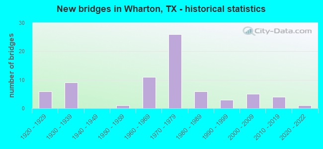
- New bridges - historical statistics
- 61920-1929
- 91930-1939
- 11950-1959
- 111960-1969
- 261970-1979
- 61980-1989
- 31990-1999
- 52000-2009
- 42010-2019
- 12020-2022

- Reconstructed bridges - Historical Statistics
- 71940-1949
- 11950-1959
- 41960-1969
- 11970-1979
- 01980-1989
- 31990-1999
- 02000-2009
- 12010-2019


- Bridge Condition - Deck
- 4.4%Very good
- 53.3%Good
- 40.0%Satisfactory
- 2.2%Fair

- Bridge Condition - Superstructure
- 6.7%Very good
- 37.8%Good
- 48.9%Satisfactory
- 6.7%Fair

- Bridge Condition - Substructure
- 4.4%Very good
- 33.3%Good
- 42.2%Satisfactory
- 17.8%Fair
- 2.2%Serious

- Bridge Condition - Channel
- 13.8%Very good
- 60.3%Good
- 20.7%Satisfactory
- 5.2%Fair

- Bridge Condition - Culverts
- 42.9%Good
- 52.4%Satisfactory
- 4.8%Poor
Find on map >> Show street view
Structure Number: 132410008907029, Location: 2.40 MI SW OF FM 961 (Lat: 29.260200, Lng: -96.165469), Route carried "on" structure: US 59, Year Built: 1928, Year Reconstructed: 1948, Status: Open, Structure Length: 1.83m (6.00ft), Average Daily Traffic: 14,046 (year 2019), Truck Traffic: 2%, Average Future Daily Traffic: 19,710 (year 2033), Features Intersected: EAST FORK JONES CREEK
Minimum Vertical Clearance: 30+ m (98+ ft), Kilometerpoint: 26.924, Lanes on structure: 2, Owner: State Highway Agency, Approaching Roadway Width: 12.2m (40.0ft), Material/Design: Concrete, Design/Construction: Slab, Number Of Spans In Main Unit: 3, Length of Maximum Span: 6.1m (20.0ft), Curb-To-Curb Width: 11.9m (39.0ft), Out-to-Out Width: 12.8m (42.0ft)
Condition: Deck: Satisfactory, Superstructure: Satisfactory, Substructure: Good, Channel: Satisfactory, Operating Rating: 48.1 metric tons, Method Used To Determine Operating Rating: Load Factor (LF), Inventory Rating: 29.0 metric tons, Method Used To Determine Inventory Rating: Load Factor (LF), Structural Evaluation: Equal to present minimum criteria, Deck Geometry: Better than present minimum criteria, Waterway Adequacy: Equal to present minimum criteria, Approach Roadway Alignment: Equal to present desirable criteria, Designated Inspection Frequency: Every 24 months, Inspection Date: January 2021, Deck Structure Type: Concrete Cast-file-Place, Wearing Surface/Protective System: Wearing Surface: Bituminous
Find on map >> Show street view
Structure Number: 13241000890703, Location: 1.70 MI SW OF FM 961 (Lat: 29.266211, Lng: -96.155792), Route carried "on" structure: US 59, Year Built: 1928, Year Reconstructed: 1948, Status: Open, Structure Length: 1.22m (4.00ft), Average Daily Traffic: 14,046 (year 2019), Truck Traffic: 2%, Average Future Daily Traffic: 19,710 (year 2033), Features Intersected: BOSQUE SLOUGH
Minimum Vertical Clearance: 30+ m (98+ ft), Kilometerpoint: 25.770, Lanes on structure: 2, Owner: State Highway Agency, Approaching Roadway Width: 12.2m (40.0ft), Material/Design: Concrete, Design/Construction: Slab, Number Of Spans In Main Unit: 2, Length of Maximum Span: 6.1m (20.0ft), Curb-To-Curb Width: 11.7m (38.4ft), Out-to-Out Width: 12.6m (41.3ft)
Condition: Deck: Satisfactory, Superstructure: Satisfactory, Substructure: Good, Channel: Fair, Operating Rating: 49.9 metric tons, Method Used To Determine Operating Rating: Load Factor (LF), Inventory Rating: 29.9 metric tons, Method Used To Determine Inventory Rating: Load Factor (LF), Structural Evaluation: Equal to present minimum criteria, Deck Geometry: Better than present minimum criteria, Waterway Adequacy: Equal to present minimum criteria, Approach Roadway Alignment: Equal to present desirable criteria, Designated Inspection Frequency: Every 24 months, Inspection Date: January 2021, Deck Structure Type: Concrete Cast-file-Place, Wearing Surface/Protective System: Wearing Surface: Bituminous
Find on map >> Show street view
Structure Number: 132410008907031, Location: 0.10 MI SW OF FM 961 (Lat: 29.280006, Lng: -96.133753), Route carried "on" structure: Ramp US 59, Year Built: 1933, Year Reconstructed: 1972, Status: Open, Structure Length: 1.40m (4.59ft), Average Daily Traffic: 2,260 (year 2013), Truck Traffic: 2%, Average Future Daily Traffic: 3,170 (year 2033), Design Load: H 15, Features Intersected: DRAW
Minimum Vertical Clearance: 30+ m (98+ ft), Kilometerpoint: 23.508, Lanes on structure: 2, Owner: State Highway Agency, Approaching Roadway Width: 17.1m (56.1ft), Skew: 30 degrees, Material/Design: Concrete, Design/Construction: Culvert, Number Of Spans In Main Unit: 6, Length of Maximum Span: 2.1m (6.9ft)
Condition: Channel: Good, Culverts: Satisfactory, Operating Rating: 39.9 metric tons, Method Used To Determine Operating Rating: Load Factor (LF), Inventory Rating: 23.6 metric tons, Method Used To Determine Inventory Rating: Load Factor (LF), Structural Evaluation: Equal to present minimum criteria, Waterway Adequacy: Equal to present minimum criteria, Approach Roadway Alignment: Equal to present desirable criteria, Designated Inspection Frequency: Every 24 months, Inspection Date: January 2021
Find on map >> Show street view
Structure Number: 132410008907081, Location: 0.05 MI SW OF LP 526 (Lat: 29.245367, Lng: -96.190475), Route carried "on" structure: US 59, Year Built: 1968, Status: Open, Structure Length: 1.16m (3.81ft), Average Daily Traffic: 24,591 (year 2020), Truck Traffic: 2%, Average Future Daily Traffic: 40,880 (year 2033), Design Load: HS 20, Features Intersected: DRAW
Minimum Vertical Clearance: 30+ m (98+ ft), Kilometerpoint: 29.865, Lanes on structure: 4, Owner: State Highway Agency, Approaching Roadway Width: 23.2m (76.1ft), Skew: 20 degrees, Material/Design: Concrete, Design/Construction: Culvert, Number Of Spans In Main Unit: 4, Length of Maximum Span: 2.4m (7.9ft)
Condition: Channel: Satisfactory, Culverts: Satisfactory, Operating Rating: 39.9 metric tons, Method Used To Determine Operating Rating: Load Factor (LF), Inventory Rating: 23.6 metric tons, Method Used To Determine Inventory Rating: Load Factor (LF), Structural Evaluation: Somewhat better than minimum adequacy, Waterway Adequacy: Equal to present minimum criteria, Approach Roadway Alignment: Equal to present desirable criteria, Designated Inspection Frequency: Every 24 months, Inspection Date: Febuary 2021
Find on map >> Show street view
Structure Number: 132410008907082, Location: 3.05 MI SW OF FM 961 (Lat: 29.255022, Lng: -96.174061), Route carried "on" structure: US 59, Year Built: 1969, Status: Open, Structure Length: 0.76m (2.49ft), Average Daily Traffic: 24,880 (year 2020), Truck Traffic: 2%, Average Future Daily Traffic: 39,420 (year 2033), Design Load: HS 20, Features Intersected: DRAW
Minimum Vertical Clearance: 30+ m (98+ ft), Kilometerpoint: 27.982, Lanes on structure: 4, Owner: State Highway Agency, Approaching Roadway Width: 24.4m (80.1ft), Skew: 20 degrees, Material/Design: Concrete, Design/Construction: Culvert, Number Of Spans In Main Unit: 3, Length of Maximum Span: 2.4m (7.9ft)
Condition: Channel: Good, Culverts: Satisfactory, Operating Rating: 39.9 metric tons, Method Used To Determine Operating Rating: Load Factor (LF), Inventory Rating: 23.6 metric tons, Method Used To Determine Inventory Rating: Load Factor (LF), Structural Evaluation: Somewhat better than minimum adequacy, Waterway Adequacy: Equal to present minimum criteria, Approach Roadway Alignment: Equal to present desirable criteria, Designated Inspection Frequency: Every 24 months, Inspection Date: Febuary 2021
Find on map >> Show street view
Structure Number: 132410008907083, Location: 2.40 MI SW OF FM 961 (Lat: 29.260367, Lng: -96.165592), Route carried "on" structure: US 59, Year Built: 1969, Status: Open, Structure Length: 3.99m (13.09ft), Average Daily Traffic: 13,598 (year 2019), Truck Traffic: 2%, Average Future Daily Traffic: 19,710 (year 2033), Design Load: H 20, Features Intersected: EAST FORK JONES CREEK
Minimum Vertical Clearance: 30+ m (98+ ft), Kilometerpoint: 26.903, Lanes on structure: 2, Owner: State Highway Agency, Approaching Roadway Width: 12.2m (40.0ft), Skew: 4 degrees, Material/Design: Concrete, Design/Construction: Slab, Number Of Spans In Main Unit: 5, Length of Maximum Span: 7.9m (25.9ft), Curb-To-Curb Width: 12.1m (39.7ft), Out-to-Out Width: 12.8m (42.0ft)
Condition: Deck: Satisfactory, Superstructure: Satisfactory, Substructure: Satisfactory, Channel: Satisfactory, Operating Rating: 68.0 metric tons, Method Used To Determine Operating Rating: Load Factor (LF), Inventory Rating: 32.7 metric tons, Method Used To Determine Inventory Rating: Load Factor (LF), Structural Evaluation: Equal to present minimum criteria, Deck Geometry: Better than present minimum criteria, Waterway Adequacy: Equal to present minimum criteria, Approach Roadway Alignment: Equal to present desirable criteria, Designated Inspection Frequency: Every 24 months, Inspection Date: January 2021, Deck Structure Type: Concrete Cast-file-Place, Wearing Surface/Protective System: Wearing Surface: Bituminous
Find on map >> Show street view
Structure Number: 132410008907084, Location: 1.70 MI SW OF FM 961 (Lat: 29.266372, Lng: -96.155928), Route carried "on" structure: US 59, Year Built: 1969, Status: Open, Structure Length: 1.52m (4.99ft), Average Daily Traffic: 13,598 (year 2019), Truck Traffic: 2%, Average Future Daily Traffic: 19,710 (year 2033), Design Load: H 20, Features Intersected: BOSQUE SLOUGH
Minimum Vertical Clearance: 30+ m (98+ ft), Kilometerpoint: 25.767, Lanes on structure: 2, Owner: State Highway Agency, Approaching Roadway Width: 12.2m (40.0ft), Material/Design: Concrete, Design/Construction: Slab, Number Of Spans In Main Unit: 2, Length of Maximum Span: 7.6m (24.9ft), Curb-To-Curb Width: 12.1m (39.7ft), Out-to-Out Width: 12.8m (42.0ft)
Condition: Deck: Satisfactory, Superstructure: Satisfactory, Substructure: Good, Channel: Good, Operating Rating: 49.9 metric tons, Method Used To Determine Operating Rating: Load Factor (LF), Inventory Rating: 29.0 metric tons, Method Used To Determine Inventory Rating: Load Factor (LF), Structural Evaluation: Equal to present minimum criteria, Deck Geometry: Better than present minimum criteria, Waterway Adequacy: Equal to present minimum criteria, Approach Roadway Alignment: Equal to present desirable criteria, Designated Inspection Frequency: Every 24 months, Inspection Date: January 2021, Deck Structure Type: Concrete Cast-file-Place, Wearing Surface/Protective System: Wearing Surface: Bituminous
Find on map >> Show street view
Structure Number: 132410008907123, Location: 0.15 MI SW OF FM 961 (Lat: 29.279689, Lng: -96.135550), Route carried "on" structure: Ramp State highway 59, Year Built: 1972, Status: Open, Structure Length: 14.78m (48.49ft), Average Daily Traffic: 5,400 (year 2010), Truck Traffic: 10%, Average Future Daily Traffic: 4,000 (year 2027), Design Load: HS 20, Features Intersected: US 59
Minimum Vertical Clearance: 30+ m (98+ ft), Kilometerpoint: 23.273, Lanes on structure: 1, Lanes under structure: 4, Owner: State Highway Agency, Approaching Roadway Width: 12.2m (40.0ft), Skew: 4 degrees, Material/Design: Prestressed concrete, Design/Construction: Stringer/Multi-beam, Number Of Spans In Main Unit: 2, Number Of Approach Spans: 5, Length of Maximum Span: 35.1m (115.2ft), Curb-To-Curb Width: 12.2m (40.0ft), Out-to-Out Width: 12.9m (42.3ft)
Condition: Deck: Good, Superstructure: Good, Substructure: Good, Operating Rating: 49.9 metric tons, Method Used To Determine Operating Rating: Load Factor (LF), Inventory Rating: 23.6 metric tons, Method Used To Determine Inventory Rating: Load Factor (LF), Structural Evaluation: Somewhat better than minimum adequacy, Deck Geometry: Superior to present desirable criteria, Underclear: Better than present minimum criteria, Approach Roadway Alignment: Equal to present desirable criteria, Designated Inspection Frequency: Every 24 months, Inspection Date: January 2021, Deck Structure Type: Concrete Cast-file-Place, Wearing Surface/Protective System: Wearing Surface: Bituminous
Find on map >> Show street view
Structure Number: 132410008907124, Location: 0.07 MI S OF FM 961 (Lat: 29.280575, Lng: -96.134803), Route carried "on" structure: US 59, Year Built: 1972, Status: Open, Structure Length: 0.98m (3.22ft), Average Daily Traffic: 24,880 (year 2020), Truck Traffic: 2%, Average Future Daily Traffic: 31,710 (year 2033), Design Load: HS 20, Features Intersected: DRAW
Minimum Vertical Clearance: 30+ m (98+ ft), Kilometerpoint: 23.162, Lanes on structure: 4, Owner: State Highway Agency, Approaching Roadway Width: 25.3m (83.0ft), Skew: 30 degrees, Material/Design: Concrete, Design/Construction: Culvert, Number Of Spans In Main Unit: 5, Length of Maximum Span: 1.8m (5.9ft)
Condition: Channel: Good, Culverts: Good, Operating Rating: 39.9 metric tons, Method Used To Determine Operating Rating: Load Factor (LF), Inventory Rating: 23.6 metric tons, Method Used To Determine Inventory Rating: Load Factor (LF), Structural Evaluation: Somewhat better than minimum adequacy, Waterway Adequacy: Equal to present minimum criteria, Approach Roadway Alignment: Equal to present desirable criteria, Designated Inspection Frequency: Every 24 months, Inspection Date: Febuary 2021
Find on map >> Show street view
Structure Number: 132410008907125, Location: 3.3 MI S OF FM 102 (Lat: 29.281636, Lng: -96.134392), Route carried "on" structure: State highway 961, Year Built: 1972, Status: Open, Structure Length: 10.24m (33.60ft), Average Daily Traffic: 660 (year 2013), Truck Traffic: 12%, Average Future Daily Traffic: 930 (year 2033), Design Load: HS 20, Features Intersected: US 59
Minimum Vertical Clearance: 30+ m (98+ ft), Kilometerpoint: 25.503, Lanes on structure: 2, Lanes under structure: 4, Owner: State Highway Agency, Approaching Roadway Width: 7.9m (25.9ft), Material/Design: Prestressed concrete, Design/Construction: Stringer/Multi-beam, Number Of Spans In Main Unit: 3, Number Of Approach Spans: 2, Length of Maximum Span: 25.3m (83.0ft), Curb-To-Curb Width: 10.4m (34.1ft), Out-to-Out Width: 11.1m (36.4ft)
Condition: Deck: Good, Superstructure: Good, Substructure: Satisfactory, Operating Rating: 54.4 metric tons, Method Used To Determine Operating Rating: Assigned rating based on Load Factor Design (LFD) reported in metric tons, Inventory Rating: 32.7 metric tons, Method Used To Determine Inventory Rating: Assigned rating based on Load Factor Design (LFD) reported in metric tons, Structural Evaluation: Equal to present minimum criteria, Deck Geometry: Equal to present minimum criteria, Underclear: Better than present minimum criteria, Approach Roadway Alignment: Equal to present desirable criteria, Designated Inspection Frequency: Every 24 months, Inspection Date: January 2021, Deck Structure Type: Concrete Cast-file-Place, Wearing Surface/Protective System: Wearing Surface: Bituminous
Find on map >> Show street view
Structure Number: 132410008907126, Location: 1.3 MI S OF FM 102 (Lat: 29.308108, Lng: -96.125653), Route carried "on" structure: US 59, Year Built: 1972, Status: Open, Structure Length: 13.41m (44.00ft), Average Daily Traffic: 10,339 (year 2020), Truck Traffic: 2%, Average Future Daily Traffic: 15,850 (year 2033), Design Load: HS 20, Features Intersected: COLORADO RIVER S RELIEF
Minimum Vertical Clearance: 30+ m (98+ ft), Kilometerpoint: 19.904, Lanes on structure: 2, Owner: State Highway Agency, Approaching Roadway Width: 12.8m (42.0ft), Material/Design: Concrete, Design/Construction: Stringer/Multi-beam, Number Of Spans In Main Unit: 11, Length of Maximum Span: 12.2m (40.0ft), Curb-To-Curb Width: 12.8m (42.0ft), Out-to-Out Width: 13.5m (44.3ft)
Condition: Deck: Satisfactory, Superstructure: Satisfactory, Substructure: Good, Channel: Good, Operating Rating: 50.8 metric tons, Method Used To Determine Operating Rating: Load Factor (LF), Inventory Rating: 29.9 metric tons, Method Used To Determine Inventory Rating: Load Factor (LF), Structural Evaluation: Equal to present minimum criteria, Deck Geometry: Equal to present desirable criteria, Waterway Adequacy: Equal to present minimum criteria, Approach Roadway Alignment: Equal to present desirable criteria, Designated Inspection Frequency: Every 24 months, Inspection Date: January 2021, Deck Structure Type: Concrete Cast-file-Place, Wearing Surface/Protective System: Wearing Surface: Bituminous
Find on map >> Show street view
Structure Number: 132410008907127, Location: 1.3 MI S OF FM 102 (Lat: 29.308136, Lng: -96.125878), Route carried "on" structure: US 59, Year Built: 1972, Status: Open, Structure Length: 13.41m (44.00ft), Average Daily Traffic: 12,241 (year 2020), Truck Traffic: 2%, Average Future Daily Traffic: 15,850 (year 2033), Design Load: HS 20, Features Intersected: COLORADO RIVER S RELIEF
Minimum Vertical Clearance: 30+ m (98+ ft), Kilometerpoint: 19.904, Lanes on structure: 2, Owner: State Highway Agency, Approaching Roadway Width: 12.8m (42.0ft), Material/Design: Concrete, Design/Construction: Stringer/Multi-beam, Number Of Spans In Main Unit: 11, Length of Maximum Span: 12.2m (40.0ft), Curb-To-Curb Width: 12.8m (42.0ft), Out-to-Out Width: 13.5m (44.3ft)
Condition: Deck: Satisfactory, Superstructure: Satisfactory, Substructure: Good, Channel: Good, Operating Rating: 49.9 metric tons, Method Used To Determine Operating Rating: Load Factor (LF), Inventory Rating: 29.9 metric tons, Method Used To Determine Inventory Rating: Load Factor (LF), Structural Evaluation: Equal to present minimum criteria, Deck Geometry: Equal to present desirable criteria, Waterway Adequacy: Equal to present minimum criteria, Approach Roadway Alignment: Equal to present desirable criteria, Designated Inspection Frequency: Every 24 months, Inspection Date: January 2021, Deck Structure Type: Concrete Cast-file-Place, Wearing Surface/Protective System: Wearing Surface: Bituminous
Find on map >> Show street view
Structure Number: 132410008907128, Location: 0.9 MI S OF FM 102 (Lat: 29.314819, Lng: -96.125047), Route carried "on" structure: US 59, Year Built: 1972, Status: Open, Structure Length: 29.57m (97.01ft), Average Daily Traffic: 12,241 (year 2020), Truck Traffic: 2%, Average Future Daily Traffic: 15,850 (year 2033), Design Load: HS 20, Features Intersected: COLORADO RIVER
Minimum Vertical Clearance: 30+ m (98+ ft), Kilometerpoint: 19.248, Lanes on structure: 2, Owner: State Highway Agency, Approaching Roadway Width: 12.8m (42.0ft), Skew: 9 degrees, Material/Design: Steel continuous, Design/Construction: Stringer/Multi-beam, Number Of Spans In Main Unit: 3, Number Of Approach Spans: 6, Length of Maximum Span: 54.9m (180.1ft), Curb-To-Curb Width: 12.8m (42.0ft), Out-to-Out Width: 13.5m (44.3ft)
Condition: Deck: Satisfactory, Superstructure: Good, Substructure: Satisfactory, Channel: Satisfactory, Operating Rating: 43.5 metric tons, Method Used To Determine Operating Rating: Load Factor (LF), Inventory Rating: 25.4 metric tons, Method Used To Determine Inventory Rating: Load Factor (LF), Structural Evaluation: Equal to present minimum criteria, Deck Geometry: Equal to present desirable criteria, Waterway Adequacy: Equal to present minimum criteria, Approach Roadway Alignment: Equal to present desirable criteria, Designated Inspection Frequency: Every 24 months, Inspection Date: January 2021, Deck Structure Type: Concrete Cast-file-Place
Find on map >> Show street view
Structure Number: 132410008907129, Location: 0.9 MI S OF FM 102 (Lat: 29.312194, Lng: -96.125086), Route carried "on" structure: US 59, Year Built: 1972, Status: Open, Structure Length: 29.57m (97.01ft), Average Daily Traffic: 10,339 (year 2020), Truck Traffic: 2%, Average Future Daily Traffic: 15,850 (year 2033), Design Load: HS 20, Features Intersected: COLORADO RIVER
Minimum Vertical Clearance: 30+ m (98+ ft), Kilometerpoint: 19.241, Lanes on structure: 2, Owner: State Highway Agency, Approaching Roadway Width: 12.8m (42.0ft), Skew: 9 degrees, Material/Design: Steel continuous, Design/Construction: Stringer/Multi-beam, Number Of Spans In Main Unit: 3, Number Of Approach Spans: 6, Length of Maximum Span: 54.9m (180.1ft), Curb-To-Curb Width: 12.8m (42.0ft), Out-to-Out Width: 13.5m (44.3ft)
Condition: Deck: Satisfactory, Superstructure: Good, Substructure: Satisfactory, Channel: Satisfactory, Operating Rating: 43.5 metric tons, Method Used To Determine Operating Rating: Load Factor (LF), Inventory Rating: 25.4 metric tons, Method Used To Determine Inventory Rating: Load Factor (LF), Structural Evaluation: Equal to present minimum criteria, Deck Geometry: Equal to present desirable criteria, Waterway Adequacy: Equal to present minimum criteria, Approach Roadway Alignment: Equal to present desirable criteria, Designated Inspection Frequency: Every 24 months, Inspection Date: January 2021, Deck Structure Type: Concrete Cast-file-Place
Find on map >> Show street view
Structure Number: 13241000890713, Location: 0.75 MI S OF FM 102 (Lat: 29.316567, Lng: -96.124811), Route carried "on" structure: US 59, Year Built: 1972, Status: Open, Structure Length: 6.52m (21.39ft), Average Daily Traffic: 12,241 (year 2020), Truck Traffic: 2%, Average Future Daily Traffic: 15,850 (year 2033), Design Load: HS 20, Features Intersected: COLORADO RIVER N RELIEF
Minimum Vertical Clearance: 30+ m (98+ ft), Kilometerpoint: 19.059, Lanes on structure: 2, Owner: State Highway Agency, Approaching Roadway Width: 12.8m (42.0ft), Skew: 3 degrees, Material/Design: Concrete, Design/Construction: Stringer/Multi-beam, Number Of Spans In Main Unit: 5, Length of Maximum Span: 13.1m (43.0ft), Curb-To-Curb Width: 12.8m (42.0ft), Out-to-Out Width: 13.5m (44.3ft)
Condition: Deck: Satisfactory, Superstructure: Satisfactory, Substructure: Satisfactory, Channel: Good, Operating Rating: 39.0 metric tons, Method Used To Determine Operating Rating: Load Factor (LF), Inventory Rating: 23.6 metric tons, Method Used To Determine Inventory Rating: Load Factor (LF), Structural Evaluation: Somewhat better than minimum adequacy, Deck Geometry: Equal to present desirable criteria, Waterway Adequacy: Equal to present minimum criteria, Approach Roadway Alignment: Equal to present desirable criteria, Designated Inspection Frequency: Every 24 months, Inspection Date: January 2021, Deck Structure Type: Concrete Cast-file-Place, Wearing Surface/Protective System: Wearing Surface: Bituminous
Find on map >> Show street view
Structure Number: 132410008907131, Location: 0.75 MI S OF FM 102 (Lat: 29.315700, Lng: -96.124583), Route carried "on" structure: US 59, Year Built: 1972, Status: Open, Structure Length: 6.52m (21.39ft), Average Daily Traffic: 10,339 (year 2020), Truck Traffic: 2%, Average Future Daily Traffic: 15,850 (year 2033), Design Load: HS 20, Features Intersected: COLORADO RIVER N RELIEF
Minimum Vertical Clearance: 30+ m (98+ ft), Kilometerpoint: 19.077, Lanes on structure: 2, Owner: State Highway Agency, Approaching Roadway Width: 12.8m (42.0ft), Skew: 3 degrees, Material/Design: Concrete, Design/Construction: Stringer/Multi-beam, Number Of Spans In Main Unit: 5, Length of Maximum Span: 13.1m (43.0ft), Curb-To-Curb Width: 12.8m (42.0ft), Out-to-Out Width: 13.5m (44.3ft)
Condition: Deck: Satisfactory, Superstructure: Satisfactory, Substructure: Satisfactory, Channel: Good, Operating Rating: 49.0 metric tons, Method Used To Determine Operating Rating: Load Factor (LF), Inventory Rating: 29.0 metric tons, Method Used To Determine Inventory Rating: Load Factor (LF), Structural Evaluation: Equal to present minimum criteria, Deck Geometry: Equal to present desirable criteria, Waterway Adequacy: Equal to present minimum criteria, Approach Roadway Alignment: Equal to present desirable criteria, Designated Inspection Frequency: Every 24 months, Inspection Date: January 2021, Deck Structure Type: Concrete Cast-file-Place, Wearing Surface/Protective System: Wearing Surface: Bituminous
Find on map >> Show street view
Structure Number: 132410008907132, Location: 3.2 MI N OF FM 961 (Lat: 29.325292, Lng: -96.121503), Route carried "on" structure: US 59, Year Built: 1972, Status: Open, Structure Length: 13.56m (44.49ft), Average Daily Traffic: 10,339 (year 2020), Truck Traffic: 2%, Average Future Daily Traffic: 16,340 (year 2033), Design Load: HS 20, Features Intersected: FM 102
Minimum Vertical Clearance: 30+ m (98+ ft), Kilometerpoint: 17.899, Lanes on structure: 2, Lanes under structure: 4, Owner: State Highway Agency, Approaching Roadway Width: 12.8m (42.0ft), Material/Design: Prestressed concrete, Design/Construction: Stringer/Multi-beam, Number Of Spans In Main Unit: 7, Length of Maximum Span: 22.9m (75.1ft), Curb-To-Curb Width: 12.9m (42.3ft), Out-to-Out Width: 13.5m (44.3ft)
Condition: Deck: Good, Superstructure: Good, Substructure: Satisfactory, Operating Rating: 54.4 metric tons, Method Used To Determine Operating Rating: Assigned rating based on Load Factor Design (LFD) reported in metric tons, Inventory Rating: 32.7 metric tons, Method Used To Determine Inventory Rating: Assigned rating based on Load Factor Design (LFD) reported in metric tons, Structural Evaluation: Equal to present minimum criteria, Deck Geometry: Superior to present desirable criteria, Underclear: Equal to present desirable criteria, Approach Roadway Alignment: Equal to present desirable criteria, Designated Inspection Frequency: Every 24 months, Inspection Date: January 2021, Deck Structure Type: Concrete Cast-file-Place
Find on map >> Show street view
Structure Number: 132410008907133, Location: 3.2 MI N OF FM 961 (Lat: 29.326519, Lng: -96.121406), Route carried "on" structure: US 59, Year Built: 1972, Status: Open, Structure Length: 13.56m (44.49ft), Average Daily Traffic: 9,835 (year 2020), Truck Traffic: 2%, Average Future Daily Traffic: 16,340 (year 2033), Design Load: HS 20, Features Intersected: FM 102
Minimum Vertical Clearance: 30+ m (98+ ft), Kilometerpoint: 17.899, Lanes on structure: 2, Lanes under structure: 4, Owner: State Highway Agency, Approaching Roadway Width: 12.8m (42.0ft), Material/Design: Prestressed concrete, Design/Construction: Stringer/Multi-beam, Number Of Spans In Main Unit: 7, Length of Maximum Span: 22.9m (75.1ft), Curb-To-Curb Width: 12.9m (42.3ft), Out-to-Out Width: 13.5m (44.3ft)
Condition: Deck: Good, Superstructure: Good, Substructure: Satisfactory, Operating Rating: 54.4 metric tons, Method Used To Determine Operating Rating: Assigned rating based on Load Factor Design (LFD) reported in metric tons, Inventory Rating: 32.7 metric tons, Method Used To Determine Inventory Rating: Assigned rating based on Load Factor Design (LFD) reported in metric tons, Structural Evaluation: Equal to present minimum criteria, Deck Geometry: Superior to present desirable criteria, Underclear: Better than present minimum criteria, Approach Roadway Alignment: Equal to present desirable criteria, Designated Inspection Frequency: Every 24 months, Inspection Date: January 2021, Deck Structure Type: Concrete Cast-file-Place
Find on map >> Show street view
Structure Number: 132410008907134, Location: 0.15 MI N OF FM 102 (Lat: 29.329206, Lng: -96.121100), Route carried "on" structure: ServiceUS 59, Year Built: 1972, Status: Open, Structure Length: 0.79m (2.59ft), Average Daily Traffic: 3,080 (year 2013), Truck Traffic: 2%, Average Future Daily Traffic: 4,310 (year 2033), Design Load: HS 20, Features Intersected: CANEY CREEK
Minimum Vertical Clearance: 30+ m (98+ ft), Kilometerpoint: 17.605, Lanes on structure: 2, Owner: State Highway Agency, Approaching Roadway Width: 10.7m (35.1ft), Skew: 3 degrees, Material/Design: Concrete, Design/Construction: Culvert, Number Of Spans In Main Unit: 3, Length of Maximum Span: 2.1m (6.9ft)
Condition: Channel: Good, Culverts: Good, Operating Rating: 39.9 metric tons, Method Used To Determine Operating Rating: Load Factor (LF), Inventory Rating: 23.6 metric tons, Method Used To Determine Inventory Rating: Load Factor (LF), Structural Evaluation: Equal to present minimum criteria, Waterway Adequacy: Better than present minimum criteria, Approach Roadway Alignment: Equal to present desirable criteria, Designated Inspection Frequency: Every 24 months, Inspection Date: Febuary 2021
Find on map >> Show street view
Structure Number: 132410008907135, Location: 0.20 MI N OF FM 102 (Lat: 29.329364, Lng: -96.120069), Route carried "on" structure: US 59, Year Built: 1972, Status: Open, Structure Length: 0.79m (2.59ft), Average Daily Traffic: 18,336 (year 2020), Truck Traffic: 2%, Average Future Daily Traffic: 32,690 (year 2033), Design Load: HS 20, Features Intersected: CANEY CREEK
Minimum Vertical Clearance: 30+ m (98+ ft), Kilometerpoint: 17.555, Lanes on structure: 6, Owner: State Highway Agency, Approaching Roadway Width: 36.6m (120.1ft), Skew: 33 degrees, Material/Design: Concrete, Design/Construction: Culvert, Number Of Spans In Main Unit: 3, Length of Maximum Span: 2.1m (6.9ft)
Condition: Channel: Good, Culverts: Satisfactory, Operating Rating: 39.9 metric tons, Method Used To Determine Operating Rating: Load Factor (LF), Inventory Rating: 23.6 metric tons, Method Used To Determine Inventory Rating: Load Factor (LF), Structural Evaluation: Somewhat better than minimum adequacy, Waterway Adequacy: Equal to present minimum criteria, Approach Roadway Alignment: Equal to present desirable criteria, Designated Inspection Frequency: Every 24 months, Inspection Date: Febuary 2021
Find on map >> Show street view
Structure Number: 132410008908136, Location: 0.25 MI N OF FM 102 (Lat: 29.329639, Lng: -96.119039), Route carried "on" structure: ServiceUS 59, Year Built: 1972, Status: Open, Structure Length: 0.82m (2.69ft), Average Daily Traffic: 3,080 (year 2013), Truck Traffic: 2%, Average Future Daily Traffic: 4,310 (year 2033), Design Load: HS 20, Features Intersected: CANEY CREEK
Minimum Vertical Clearance: 30+ m (98+ ft), Kilometerpoint: 17.495, Lanes on structure: 2, Owner: State Highway Agency, Approaching Roadway Width: 11.6m (38.1ft), Skew: 3 degrees, Material/Design: Concrete, Design/Construction: Culvert, Number Of Spans In Main Unit: 3, Length of Maximum Span: 2.1m (6.9ft)
Condition: Channel: Good, Culverts: Good, Operating Rating: 39.9 metric tons, Method Used To Determine Operating Rating: Load Factor (LF), Inventory Rating: 23.6 metric tons, Method Used To Determine Inventory Rating: Load Factor (LF), Structural Evaluation: Equal to present minimum criteria, Waterway Adequacy: Better than present minimum criteria, Approach Roadway Alignment: Equal to present desirable criteria, Designated Inspection Frequency: Every 24 months, Inspection Date: Febuary 2021
Find on map >> Show street view
Structure Number: 132410008908137, Location: 1.45 MI N OF FM 102 (Lat: 29.346464, Lng: -96.113447), Route carried "on" structure: US 59, Year Built: 1972, Status: Open, Structure Length: 1.04m (3.41ft), Average Daily Traffic: 18,336 (year 2020), Truck Traffic: 2%, Average Future Daily Traffic: 32,690 (year 2033), Design Load: HS 20, Features Intersected: BAUGHMAN SLOUGH
Minimum Vertical Clearance: 30+ m (98+ ft), Kilometerpoint: 15.554, Lanes on structure: 4, Owner: State Highway Agency, Approaching Roadway Width: 25.0m (82.0ft), Skew: 21 degrees, Material/Design: Concrete, Design/Construction: Culvert, Number Of Spans In Main Unit: 3, Length of Maximum Span: 3.0m (9.8ft)
Condition: Channel: Good, Culverts: Good, Operating Rating: 39.9 metric tons, Method Used To Determine Operating Rating: Load Factor (LF), Inventory Rating: 23.6 metric tons, Method Used To Determine Inventory Rating: Load Factor (LF), Structural Evaluation: Somewhat better than minimum adequacy, Waterway Adequacy: Equal to present minimum criteria, Approach Roadway Alignment: Equal to present desirable criteria, Designated Inspection Frequency: Every 24 months, Inspection Date: Febuary 2021
Find on map >> Show street view
Structure Number: 132410008908138, Location: 3.00 MI N OF FM 102 (Lat: 29.362981, Lng: -96.096197), Route carried "on" structure: US 59, Year Built: 1972, Status: Open, Structure Length: 9.11m (29.89ft), Average Daily Traffic: 9,835 (year 2020), Truck Traffic: 2%, Average Future Daily Traffic: 16,340 (year 2033), Design Load: HS 20, Features Intersected: PEACH CREEK
Minimum Vertical Clearance: 30+ m (98+ ft), Kilometerpoint: 12.975, Lanes on structure: 2, Owner: State Highway Agency, Approaching Roadway Width: 12.8m (42.0ft), Skew: 3 degrees, Material/Design: Concrete, Design/Construction: Stringer/Multi-beam, Number Of Spans In Main Unit: 7, Length of Maximum Span: 13.1m (43.0ft), Curb-To-Curb Width: 12.8m (42.0ft), Out-to-Out Width: 13.5m (44.3ft)
Condition: Deck: Satisfactory, Superstructure: Satisfactory, Substructure: Satisfactory, Channel: Good, Operating Rating: 54.4 metric tons, Method Used To Determine Operating Rating: Assigned rating based on Load Factor Design (LFD) reported in metric tons, Inventory Rating: 32.7 metric tons, Method Used To Determine Inventory Rating: Assigned rating based on Load Factor Design (LFD) reported in metric tons, Structural Evaluation: Equal to present minimum criteria, Deck Geometry: Equal to present desirable criteria, Waterway Adequacy: Equal to present minimum criteria, Approach Roadway Alignment: Equal to present desirable criteria, Designated Inspection Frequency: Every 24 months, Inspection Date: January 2021, Deck Structure Type: Concrete Cast-file-Place, Wearing Surface/Protective System: Wearing Surface: Bituminous
Find on map >> Show street view
Structure Number: 132410008908139, Location: 3.00 MI N OF FM 102 (Lat: 29.362825, Lng: -96.096036), Route carried "on" structure: US 59, Year Built: 1972, Status: Open, Structure Length: 9.11m (29.89ft), Average Daily Traffic: 10,999 (year 2019), Truck Traffic: 2%, Average Future Daily Traffic: 16,340 (year 2033), Design Load: HS 20, Features Intersected: PEACH CREEK
Minimum Vertical Clearance: 30+ m (98+ ft), Kilometerpoint: 12.957, Lanes on structure: 2, Owner: State Highway Agency, Approaching Roadway Width: 12.8m (42.0ft), Skew: 3 degrees, Material/Design: Concrete, Design/Construction: Stringer/Multi-beam, Number Of Spans In Main Unit: 7, Length of Maximum Span: 13.1m (43.0ft), Curb-To-Curb Width: 12.8m (42.0ft), Out-to-Out Width: 13.5m (44.3ft)
Condition: Deck: Satisfactory, Superstructure: Satisfactory, Substructure: Satisfactory, Channel: Good, Operating Rating: 54.4 metric tons, Method Used To Determine Operating Rating: Assigned rating based on Load Factor Design (LFD) reported in metric tons, Inventory Rating: 32.7 metric tons, Method Used To Determine Inventory Rating: Assigned rating based on Load Factor Design (LFD) reported in metric tons, Structural Evaluation: Equal to present minimum criteria, Deck Geometry: Equal to present desirable criteria, Waterway Adequacy: Equal to present minimum criteria, Approach Roadway Alignment: Equal to present desirable criteria, Designated Inspection Frequency: Every 24 months, Inspection Date: January 2021, Deck Structure Type: Concrete Cast-file-Place, Wearing Surface/Protective System: Wearing Surface: Bituminous
Find on map >> Show street view
Structure Number: 13241000890814, Location: 3.50 MI NE OF FM 102 (Lat: 29.366878, Lng: -96.090578), Route carried "on" structure: US 59, Year Built: 1972, Status: Open, Structure Length: 22.52m (73.88ft), Average Daily Traffic: 9,835 (year 2020), Truck Traffic: 2%, Average Future Daily Traffic: 16,490 (year 2033), Design Load: HS 20, Features Intersected: SH 60/ BU 59 R & KCS RR
Minimum Vertical Clearance: 30+ m (98+ ft), Kilometerpoint: 12.175, Lanes on structure: 2, Lanes under structure: 6, Owner: State Highway Agency, Approaching Roadway Width: 12.8m (42.0ft), Skew: 5 degrees, Material/Design: Prestressed concrete, Design/Construction: Stringer/Multi-beam, Number Of Spans In Main Unit: 2, Number Of Approach Spans: 9, Length of Maximum Span: 30.5m (100.1ft), Curb-To-Curb Width: 12.8m (42.0ft), Out-to-Out Width: 13.5m (44.3ft)
Condition: Deck: Good, Superstructure: Good, Substructure: Good, Operating Rating: 54.4 metric tons, Method Used To Determine Operating Rating: Assigned rating based on Load Factor Design (LFD) reported in metric tons, Inventory Rating: 32.7 metric tons, Method Used To Determine Inventory Rating: Assigned rating based on Load Factor Design (LFD) reported in metric tons, Structural Evaluation: Better than present minimum criteria, Deck Geometry: Equal to present desirable criteria, Underclear: Equal to present minimum criteria, Approach Roadway Alignment: Equal to present desirable criteria, Designated Inspection Frequency: Every 24 months, Inspection Date: Febuary 2021, Deck Structure Type: Concrete Cast-file-Place, Wearing Surface/Protective System: Wearing Surface: Bituminous
Find on map >> Show street view
Structure Number: 132410008908141, Location: 3.50 MI NE OF FM 102 (Lat: 29.366733, Lng: -96.090478), Route carried "on" structure: US 59, Year Built: 1972, Status: Open, Structure Length: 22.52m (73.88ft), Average Daily Traffic: 10,999 (year 2019), Truck Traffic: 2%, Average Future Daily Traffic: 16,490 (year 2033), Design Load: HS 20, Features Intersected: SH 60/ BU 59 R & KCS RR
Minimum Vertical Clearance: 30+ m (98+ ft), Kilometerpoint: 12.200, Lanes on structure: 2, Lanes under structure: 6, Owner: State Highway Agency, Approaching Roadway Width: 12.8m (42.0ft), Skew: 5 degrees, Material/Design: Prestressed concrete, Design/Construction: Stringer/Multi-beam, Number Of Spans In Main Unit: 2, Number Of Approach Spans: 9, Length of Maximum Span: 30.5m (100.1ft), Curb-To-Curb Width: 12.8m (42.0ft), Out-to-Out Width: 13.5m (44.3ft)
Condition: Deck: Good, Superstructure: Good, Substructure: Good, Operating Rating: 54.4 metric tons, Method Used To Determine Operating Rating: Assigned rating based on Load Factor Design (LFD) reported in metric tons, Inventory Rating: 32.7 metric tons, Method Used To Determine Inventory Rating: Assigned rating based on Load Factor Design (LFD) reported in metric tons, Structural Evaluation: Better than present minimum criteria, Deck Geometry: Equal to present desirable criteria, Underclear: Equal to present minimum criteria, Approach Roadway Alignment: Equal to present desirable criteria, Designated Inspection Frequency: Every 24 months, Inspection Date: Febuary 2021, Deck Structure Type: Concrete Cast-file-Place, Wearing Surface/Protective System: Wearing Surface: Bituminous
Find on map >> Show street view
Structure Number: 132410008910032, Location: 0.55 MI NE OF FM 961 (Lat: 29.285297, Lng: -96.125078), Route carried "on" structure: Business State highway 59, Year Built: 1933, Year Reconstructed: 1948, Status: Open, Structure Length: 2.65m (8.69ft), Average Daily Traffic: 5,200 (year 2010), Truck Traffic: 23%, Average Future Daily Traffic: 7,280 (year 2029), Features Intersected: COLORADO RIVER RELIEF
Minimum Vertical Clearance: 30+ m (98+ ft), Kilometerpoint: 63.788, Lanes on structure: 2, Owner: State Highway Agency, Approaching Roadway Width: 12.2m (40.0ft), Material/Design: Concrete, Design/Construction: Culvert, Number Of Spans In Main Unit: 8, Length of Maximum Span: 3.0m (9.8ft), Curb-To-Curb Width: 12.2m (40.0ft), Out-to-Out Width: 12.8m (42.0ft)
Condition: Channel: Good, Culverts: Satisfactory, Operating Rating: 39.9 metric tons, Method Used To Determine Operating Rating: Load Factor (LF), Inventory Rating: 23.6 metric tons, Method Used To Determine Inventory Rating: Load Factor (LF), Structural Evaluation: Somewhat better than minimum adequacy, Deck Geometry: Somewhat better than minimum adequacy, Waterway Adequacy: Equal to present minimum criteria, Approach Roadway Alignment: Equal to present desirable criteria, Designated Inspection Frequency: Every 24 months, Inspection Date: January 2021, Deck Structure Type: Concrete Cast-file-Place, Wearing Surface/Protective System: Wearing Surface: Bituminous
Find on map >> Show street view
Structure Number: 132410008910033, Location: 0.65 MI NE OF FM 961 (Lat: 29.286142, Lng: -96.123794), Route carried "on" structure: Business State highway 59, Year Built: 1933, Year Reconstructed: 1948, Status: Open, Structure Length: 1.19m (3.90ft), Average Daily Traffic: 5,200 (year 2010), Truck Traffic: 23%, Average Future Daily Traffic: 7,280 (year 2029), Features Intersected: COLORADO RIVER RELIEF
Minimum Vertical Clearance: 30+ m (98+ ft), Kilometerpoint: 63.646, Lanes on structure: 2, Owner: State Highway Agency, Approaching Roadway Width: 12.2m (40.0ft), Material/Design: Concrete, Design/Construction: Culvert, Number Of Spans In Main Unit: 5, Length of Maximum Span: 2.1m (6.9ft), Curb-To-Curb Width: 12.2m (40.0ft), Out-to-Out Width: 12.6m (41.3ft)
Condition: Channel: Good, Culverts: Satisfactory, Operating Rating: 39.9 metric tons, Method Used To Determine Operating Rating: Load Factor (LF), Inventory Rating: 23.6 metric tons, Method Used To Determine Inventory Rating: Load Factor (LF), Structural Evaluation: Somewhat better than minimum adequacy, Deck Geometry: Somewhat better than minimum adequacy, Waterway Adequacy: Equal to present minimum criteria, Approach Roadway Alignment: Equal to present desirable criteria, Designated Inspection Frequency: Every 24 months, Inspection Date: January 2021, Deck Structure Type: Concrete Cast-file-Place, Wearing Surface/Protective System: Wearing Surface: Bituminous
Find on map >> Show street view
Structure Number: 132410008910034, Location: 0.70 MI NE OF FM 961 (Lat: 29.286447, Lng: -96.123292), Route carried "on" structure: Business State highway 59, Year Built: 1933, Year Reconstructed: 1948, Status: Open, Structure Length: 2.13m (6.99ft), Average Daily Traffic: 5,200 (year 2010), Truck Traffic: 23%, Average Future Daily Traffic: 7,280 (year 2029), Features Intersected: COLORADO RIVER RELIEF
Minimum Vertical Clearance: 30+ m (98+ ft), Kilometerpoint: 63.588, Lanes on structure: 2, Owner: State Highway Agency, Approaching Roadway Width: 12.2m (40.0ft), Material/Design: Concrete, Design/Construction: Culvert, Number Of Spans In Main Unit: 9, Length of Maximum Span: 2.1m (6.9ft), Curb-To-Curb Width: 12.2m (40.0ft), Out-to-Out Width: 12.8m (42.0ft)
Condition: Channel: Good, Culverts: Satisfactory, Operating Rating: 39.9 metric tons, Method Used To Determine Operating Rating: Load Factor (LF), Inventory Rating: 23.6 metric tons, Method Used To Determine Inventory Rating: Load Factor (LF), Structural Evaluation: Somewhat better than minimum adequacy, Deck Geometry: Somewhat better than minimum adequacy, Waterway Adequacy: Equal to present minimum criteria, Approach Roadway Alignment: Equal to present desirable criteria, Designated Inspection Frequency: Every 24 months, Inspection Date: January 2021, Deck Structure Type: Concrete Cast-file-Place, Wearing Surface/Protective System: Wearing Surface: Bituminous
Find on map >> Show street view
Structure Number: 132410008910035, Location: 1.50 MI NE OF FM 961 (Lat: 29.294089, Lng: -96.112669), Route carried "on" structure: Business State highway 59, Year Built: 1933, Year Reconstructed: 1948, Status: Open, Structure Length: 0.79m (2.59ft), Average Daily Traffic: 4,980 (year 2013), Truck Traffic: 21%, Average Future Daily Traffic: 6,970 (year 2033), Features Intersected: COLORADO RIVER RELIEF
Minimum Vertical Clearance: 30+ m (98+ ft), Kilometerpoint: 62.254, Lanes on structure: 2, Owner: State Highway Agency, Approaching Roadway Width: 12.2m (40.0ft), Material/Design: Concrete, Design/Construction: Culvert, Number Of Spans In Main Unit: 4, Length of Maximum Span: 1.8m (5.9ft)
Condition: Channel: Good, Culverts: Good, Operating Rating: 39.9 metric tons, Method Used To Determine Operating Rating: Load Factor (LF), Inventory Rating: 23.6 metric tons, Method Used To Determine Inventory Rating: Load Factor (LF), Structural Evaluation: Equal to present minimum criteria, Waterway Adequacy: Equal to present minimum criteria, Approach Roadway Alignment: Equal to present desirable criteria, Designated Inspection Frequency: Every 24 months, Inspection Date: Febuary 2021
Find on map >> Show street view
Structure Number: 132410008910036, Location: 1.70 MI NE OF FM 961 (Lat: 29.296267, Lng: -96.111011), Route carried "on" structure: Business State highway 59, Year Built: 1933, Year Reconstructed: 1948, Status: Open, Structure Length: 0.82m (2.69ft), Average Daily Traffic: 4,980 (year 2013), Truck Traffic: 21%, Average Future Daily Traffic: 6,970 (year 2033), Features Intersected: COLORADO RIVER RELIEF
Minimum Vertical Clearance: 30+ m (98+ ft), Kilometerpoint: 61.968, Lanes on structure: 2, Owner: State Highway Agency, Approaching Roadway Width: 12.2m (40.0ft), Material/Design: Concrete, Design/Construction: Culvert, Number Of Spans In Main Unit: 4, Length of Maximum Span: 1.8m (5.9ft), Curb-To-Curb Width: 12.2m (40.0ft), Out-to-Out Width: 12.6m (41.3ft)
Condition: Channel: Good, Culverts: Satisfactory, Operating Rating: 39.9 metric tons, Method Used To Determine Operating Rating: Load Factor (LF), Inventory Rating: 23.6 metric tons, Method Used To Determine Inventory Rating: Load Factor (LF), Structural Evaluation: Equal to present minimum criteria, Deck Geometry: Equal to present minimum criteria, Waterway Adequacy: Equal to present minimum criteria, Approach Roadway Alignment: Equal to present desirable criteria, Designated Inspection Frequency: Every 24 months, Inspection Date: Febuary 2021, Deck Structure Type: Concrete Cast-file-Place, Wearing Surface/Protective System: Wearing Surface: Bituminous
Find on map >> Show street view
Structure Number: 132410008910037, Location: 2.15 MI NE OF FM 961 (Lat: 29.302008, Lng: -96.106411), Route carried "on" structure: Business State highway 59, Year Built: 1932, Year Reconstructed: 1965, Status: Open, Structure Length: 0.82m (2.69ft), Average Daily Traffic: 4,980 (year 2013), Truck Traffic: 21%, Average Future Daily Traffic: 6,970 (year 2033), Features Intersected: COLORADO RIVER RELIEF
Minimum Vertical Clearance: 30+ m (98+ ft), Kilometerpoint: 61.173, Lanes on structure: 2, Owner: State Highway Agency, Approaching Roadway Width: 21.9m (71.9ft), Material/Design: Concrete, Design/Construction: Culvert, Number Of Spans In Main Unit: 4, Length of Maximum Span: 1.8m (5.9ft)
Condition: Channel: Good, Culverts: Poor, Operating Rating: 22.7 metric tons, Method Used To Determine Operating Rating: Field evaluation and documented engineering judgment, Inventory Rating: 17.0 metric tons, Method Used To Determine Inventory Rating: Field evaluation and documented engineering judgment, Structural Evaluation: Meets minimum limits, Waterway Adequacy: Equal to present minimum criteria, Approach Roadway Alignment: Equal to present desirable criteria, Designated Inspection Frequency: Every 24 months, Inspection Date: Febuary 2021
Find on map >> Show street view
Structure Number: 132410008910038, Location: 0.60 MI S OF SH 60 (Lat: 29.304072, Lng: -96.104997), Route carried "on" structure: Business State highway 59, Year Built: 1931, Status: Open, Structure Length: 4.36m (14.30ft), Average Daily Traffic: 4,803 (year 2018), Truck Traffic: 21%, Average Future Daily Traffic: 3,480 (year 2033), Design Load: H 15, Features Intersected: KCS RR
Minimum Vertical Clearance: 30+ m (98+ ft), Kilometerpoint: 60.891, Lanes on structure: 1, Owner: State Highway Agency, Approaching Roadway Width: 9.1m (29.9ft), Skew: 3 degrees, Material/Design: Steel, Number Of Spans In Main Unit: 2, Number Of Approach Spans: 4, Length of Maximum Span: 7.3m (24.0ft), Curb-To-Curb Width: 7.1m (23.3ft), Out-to-Out Width: 8.2m (26.9ft)
Condition: Deck: Satisfactory, Superstructure: Satisfactory, Substructure: Satisfactory, Operating Rating: 52.6 metric tons, Method Used To Determine Operating Rating: Load Factor (LF), Inventory Rating: 30.8 metric tons, Method Used To Determine Inventory Rating: Load Factor (LF), Structural Evaluation: Equal to present minimum criteria, Deck Geometry: High priority of replacement, Underclear: Meets minimum limits, Approach Roadway Alignment: Equal to present desirable criteria, Length Of Structure Improvement: 4.36m (14.30ft), Designated Inspection Frequency: Every 24 months, Inspection Date: January 2021, Bridge Improvement Cost: $7,000, Roadway Improvement Cost: $2,000, Total Project Cost: $9,000, Deck Structure Type: Concrete Cast-file-Place, Wearing Surface/Protective System: Wearing Surface: Bituminous
Find on map >> Show street view
Structure Number: 132410008910039, Location: 0.25 MI S OF SH 60 (Lat: 29.307836, Lng: -96.103981), Route carried "on" structure: Business State highway 59, Year Built: 1930, Year Reconstructed: 2018, Status: Open, Structure Length: 34.35m (112.70ft), Average Daily Traffic: 2,490 (year 2013), Truck Traffic: 21%, Average Future Daily Traffic: 3,480 (year 2033), Design Load: H 15, Features Intersected: COLORADO RIVER
Minimum Vertical Clearance: 4.88m (16.01ft), Kilometerpoint: 60.297, Lanes on structure: 1, Owner: State Highway Agency, Approaching Roadway Width: 6.1m (20.0ft), Material/Design: Steel, Design/Construction: Truss - Thru, Number Of Spans In Main Unit: 1, Number Of Approach Spans: 22, Length of Maximum Span: 97.5m (319.9ft), Curb-To-Curb Width: 5.2m (17.1ft), Out-to-Out Width: 6.1m (20.0ft)
Condition: Deck: Good, Superstructure: Satisfactory, Substructure: Fair, Channel: Satisfactory, Operating Rating: 53.5 metric tons, Method Used To Determine Operating Rating: Load Factor (LF), Inventory Rating: 31.7 metric tons, Method Used To Determine Inventory Rating: Load Factor (LF), Structural Evaluation: Somewhat better than minimum adequacy, Deck Geometry: High priority of replacement, Waterway Adequacy: Superior to present desirable criteria, Approach Roadway Alignment: Equal to present desirable criteria, Length Of Structure Improvement: 34.35m (112.70ft), Designated Inspection Frequency: Every 24 months, Critical Feature Inspection Frequency: Every 24 months, Inspection Date: Febuary 2021, Critical Feature Inspection Date: Febuary 2021, Bridge Improvement Cost: $45,000, Roadway Improvement Cost: $11,000, Total Project Cost: $56,000, Deck Structure Type: Concrete Cast-file-Place
Find on map >> Show street view
Structure Number: 13241000891004, Location: 1.60 MI S OF US 59 (Lat: 29.345122, Lng: -96.090514), Route carried "on" structure: State highway 60, Year Built: 1928, Year Reconstructed: 1977, Status: Open, Structure Length: 1.07m (3.51ft), Average Daily Traffic: 7,742 (year 2020), Truck Traffic: 7%, Average Future Daily Traffic: 9,070 (year 2033), Design Load: H 15, Features Intersected: BAUGHMAN SLOUGH
Minimum Vertical Clearance: 30+ m (98+ ft), Kilometerpoint: 56.126, Lanes on structure: 2, Owner: State Highway Agency, Approaching Roadway Width: 12.2m (40.0ft), Material/Design: Concrete, Design/Construction: Culvert, Number Of Spans In Main Unit: 4, Length of Maximum Span: 2.4m (7.9ft)
Condition: Channel: Good, Culverts: Satisfactory, Operating Rating: 39.9 metric tons, Method Used To Determine Operating Rating: Load Factor (LF), Inventory Rating: 23.6 metric tons, Method Used To Determine Inventory Rating: Load Factor (LF), Structural Evaluation: Somewhat better than minimum adequacy, Waterway Adequacy: Equal to present minimum criteria, Approach Roadway Alignment: Equal to present desirable criteria, Designated Inspection Frequency: Every 24 months, Inspection Date: January 2021
Find on map >> Show street view
Structure Number: 132410008910041, Location: 0.35 MI S OF US 59 (Lat: 29.361969, Lng: -96.091375), Route carried "on" structure: State highway 60, Year Built: 1928, Year Reconstructed: 1972, Status: Open, Structure Length: 9.85m (32.32ft), Average Daily Traffic: 7,296 (year 2020), Truck Traffic: 9%, Average Future Daily Traffic: 8,190 (year 2033), Features Intersected: PEACH CREEK
Minimum Vertical Clearance: 30+ m (98+ ft), Kilometerpoint: 54.090, Lanes on structure: 5, Owner: State Highway Agency, Approaching Roadway Width: 25.6m (84.0ft), Material/Design: Concrete, Design/Construction: Slab, Number Of Spans In Main Unit: 16, Length of Maximum Span: 6.4m (21.0ft), Curb-To-Curb Width: 25.6m (84.0ft), Out-to-Out Width: 26.3m (86.3ft)
Condition: Deck: Satisfactory, Superstructure: Satisfactory, Substructure: Satisfactory, Channel: Satisfactory, Operating Rating: 32.7 metric tons, Method Used To Determine Operating Rating: Field evaluation and documented engineering judgment, Inventory Rating: 24.5 metric tons, Method Used To Determine Inventory Rating: Field evaluation and documented engineering judgment, Structural Evaluation: Equal to present minimum criteria, Deck Geometry: Superior to present desirable criteria, Waterway Adequacy: Equal to present minimum criteria, Approach Roadway Alignment: Equal to present desirable criteria, Designated Inspection Frequency: Every 24 months, Inspection Date: January 2021, Deck Structure Type: Concrete Cast-file-Place, Wearing Surface/Protective System: Wearing Surface: Bituminous
Find on map >> Show street view
Structure Number: 132410008910064, Location: 0.60 MI S OF SH 60 (Lat: 29.303989, Lng: -96.104814), Route carried "on" structure: Business State highway 59, Year Built: 1965, Status: Open, Structure Length: 5.49m (18.01ft), Average Daily Traffic: 2,490 (year 2013), Truck Traffic: 21%, Average Future Daily Traffic: 3,480 (year 2033), Design Load: H 20, Features Intersected: KCS RR
Minimum Vertical Clearance: 30+ m (98+ ft), Kilometerpoint: 60.898, Lanes on structure: 1, Owner: State Highway Agency, Approaching Roadway Width: 11.0m (36.1ft), Skew: 3 degrees, Material/Design: Steel continuous, Design/Construction: Stringer/Multi-beam, Number Of Spans In Main Unit: 3, Length of Maximum Span: 18.3m (60.0ft), Curb-To-Curb Width: 8.5m (27.9ft), Out-to-Out Width: 9.5m (31.2ft)
Condition: Deck: Good, Superstructure: Satisfactory, Substructure: Satisfactory, Operating Rating: 43.5 metric tons, Method Used To Determine Operating Rating: Load Factor (LF), Inventory Rating: 26.3 metric tons, Method Used To Determine Inventory Rating: Load Factor (LF), Structural Evaluation: Equal to present minimum criteria, Deck Geometry: Meets minimum limits, Underclear: Meets minimum limits, Approach Roadway Alignment: Equal to present desirable criteria, Length Of Structure Improvement: 5.49m (18.01ft), Designated Inspection Frequency: Every 24 months, Inspection Date: January 2021, Bridge Improvement Cost: $10,000, Roadway Improvement Cost: $3,000, Total Project Cost: $13,000, Deck Structure Type: Concrete Cast-file-Place, Wearing Surface/Protective System: Wearing Surface: Bituminous
Find on map >> Show street view
Structure Number: 132410008910065, Location: 0.25 MI S OF SH 60 (Lat: 29.307817, Lng: -96.103758), Route carried "on" structure: Business State highway 59, Year Built: 1965, Status: Open, Structure Length: 34.26m (112.40ft), Average Daily Traffic: 5,200 (year 2010), Truck Traffic: 23%, Average Future Daily Traffic: 7,280 (year 2029), Design Load: H 20, Features Intersected: COLORADO RIVER
Minimum Vertical Clearance: 30+ m (98+ ft), Kilometerpoint: 60.297, Lanes on structure: 1, Owner: State Highway Agency, Approaching Roadway Width: 11.6m (38.1ft), Material/Design: Steel continuous, Design/Construction: Stringer/Multi-beam, Number Of Spans In Main Unit: 4, Number Of Approach Spans: 9, Length of Maximum Span: 50.3m (165.0ft), Curb or Sidewalk Widths: Left: 0.0m, Right: 1.2m (3.9ft), Curb-To-Curb Width: 8.5m (27.9ft), Out-to-Out Width: 10.5m (34.4ft)
Condition: Deck: Satisfactory, Superstructure: Satisfactory, Substructure: Fair, Channel: Fair, Operating Rating: 65.3 metric tons, Method Used To Determine Operating Rating: Load Factor (LF), Inventory Rating: 38.1 metric tons, Method Used To Determine Inventory Rating: Load Factor (LF), Structural Evaluation: Somewhat better than minimum adequacy, Deck Geometry: Meets minimum limits, Waterway Adequacy: Superior to present desirable criteria, Approach Roadway Alignment: Equal to present desirable criteria, Length Of Structure Improvement: 34.26m (112.40ft), Designated Inspection Frequency: Every 24 months, Inspection Date: January 2021, Bridge Improvement Cost: $63,000, Roadway Improvement Cost: $16,000, Total Project Cost: $79,000, Deck Structure Type: Concrete Cast-file-Place
Find on map >> Show street view
Structure Number: 132410008916027, Location: 0.5 MI SW OF US 59 (Lat: 29.241650, Lng: -96.195553), Route carried "on" structure: State highway 526, Year Built: 1928, Year Reconstructed: 1964, Status: Open, Structure Length: 3.05m (10.01ft), Average Daily Traffic: 100 (year 2020), Truck Traffic: 21%, Average Future Daily Traffic: 160 (year 2033), Features Intersected: JONES CREEK
Minimum Vertical Clearance: 30+ m (98+ ft), Kilometerpoint: 45.691, Lanes on structure: 2, Owner: State Highway Agency, Approaching Roadway Width: 12.2m (40.0ft), Material/Design: Concrete, Design/Construction: Slab, Number Of Spans In Main Unit: 5, Length of Maximum Span: 6.1m (20.0ft), Curb-To-Curb Width: 12.2m (40.0ft), Out-to-Out Width: 12.8m (42.0ft)
Condition: Deck: Satisfactory, Superstructure: Satisfactory, Substructure: Satisfactory, Channel: Good, Operating Rating: 49.9 metric tons, Method Used To Determine Operating Rating: Load Factor (LF), Inventory Rating: 29.9 metric tons, Method Used To Determine Inventory Rating: Load Factor (LF), Structural Evaluation: Equal to present minimum criteria, Deck Geometry: Superior to present desirable criteria, Waterway Adequacy: Better than present minimum criteria, Approach Roadway Alignment: Equal to present desirable criteria, Designated Inspection Frequency: Every 24 months, Inspection Date: January 2021, Deck Structure Type: Concrete Cast-file-Place, Wearing Surface/Protective System: Wearing Surface: Bituminous
Find on map >> Show street view
Structure Number: 132410008916028, Location: 0.2 MI SW OF US 59 (Lat: 29.244839, Lng: -96.190236), Route carried "on" structure: Ramp State highway 526, Year Built: 1928, Year Reconstructed: 2004, Status: Open, Structure Length: 1.07m (3.51ft), Average Daily Traffic: 100 (year 2020), Truck Traffic: 21%, Average Future Daily Traffic: 160 (year 2033), Design Load: H 15, Features Intersected: DRAW
Minimum Vertical Clearance: 30+ m (98+ ft), Kilometerpoint: 44.983, Lanes on structure: 1, Owner: State Highway Agency, Approaching Roadway Width: 7.9m (25.9ft), Material/Design: Concrete, Design/Construction: Culvert, Number Of Spans In Main Unit: 4, Length of Maximum Span: 2.4m (7.9ft), Curb-To-Curb Width: 9.1m (29.9ft), Out-to-Out Width: 15.9m (52.2ft)
Condition: Channel: Satisfactory, Culverts: Satisfactory, Operating Rating: 39.9 metric tons, Method Used To Determine Operating Rating: Load Factor (LF), Inventory Rating: 23.6 metric tons, Method Used To Determine Inventory Rating: Load Factor (LF), Structural Evaluation: Equal to present minimum criteria, Deck Geometry: Superior to present desirable criteria, Waterway Adequacy: Better than present minimum criteria, Approach Roadway Alignment: Equal to present desirable criteria, Designated Inspection Frequency: Every 24 months, Inspection Date: January 2021, Deck Structure Type: Concrete Cast-file-Place, Wearing Surface/Protective System: Wearing Surface: Bituminous
Find on map >> Show street view
Structure Number: 132410070902004, Location: 1.8 MI W OF US 59 (Lat: 29.335861, Lng: -96.149058), Route carried "on" structure: State highway 102, Year Built: 1960, Year Reconstructed: 2004, Status: Open, Structure Length: 0.70m (2.30ft), Average Daily Traffic: 5,216 (year 2020), Truck Traffic: 8%, Average Future Daily Traffic: 7,780 (year 2033), Design Load: HS 20, Features Intersected: DRAW
Minimum Vertical Clearance: 30+ m (98+ ft), Kilometerpoint: 26.833, Lanes on structure: 2, Owner: State Highway Agency, Approaching Roadway Width: 12.8m (42.0ft), Skew: 9 degrees, Material/Design: Concrete, Design/Construction: Culvert, Number Of Spans In Main Unit: 3, Length of Maximum Span: 2.1m (6.9ft), Curb-To-Curb Width: 12.8m (42.0ft), Out-to-Out Width: 17.8m (58.4ft)
Condition: Channel: Good, Culverts: Satisfactory, Operating Rating: 39.9 metric tons, Method Used To Determine Operating Rating: Load Factor (LF), Inventory Rating: 23.6 metric tons, Method Used To Determine Inventory Rating: Load Factor (LF), Structural Evaluation: Somewhat better than minimum adequacy, Deck Geometry: Somewhat better than minimum adequacy, Waterway Adequacy: Equal to present minimum criteria, Approach Roadway Alignment: Equal to present desirable criteria, Designated Inspection Frequency: Every 24 months, Inspection Date: January 2021, Deck Structure Type: Concrete Cast-file-Place, Wearing Surface/Protective System: Wearing Surface: Bituminous
Find on map >> Show street view
Structure Number: 132410126101003, Location: 0.55 MI W OF US 59 (Lat: 29.284394, Lng: -96.142825), Route carried "on" structure: State highway 961, Year Built: 1960, Status: Open, Structure Length: 0.67m (2.20ft), Average Daily Traffic: 651 (year 2020), Truck Traffic: 12%, Average Future Daily Traffic: 930 (year 2033), Design Load: H 20, Features Intersected: IRRIGATION CANAL
Minimum Vertical Clearance: 30+ m (98+ ft), Kilometerpoint: 24.687, Lanes on structure: 2, Owner: State Highway Agency, Approaching Roadway Width: 7.9m (25.9ft), Material/Design: Concrete, Design/Construction: Culvert, Number Of Spans In Main Unit: 2, Length of Maximum Span: 3.0m (9.8ft), Curb-To-Curb Width: 9.8m (32.2ft), Out-to-Out Width: 10.2m (33.5ft)
Condition: Channel: Good, Culverts: Good, Operating Rating: 39.9 metric tons, Method Used To Determine Operating Rating: Load Factor (LF), Inventory Rating: 23.6 metric tons, Method Used To Determine Inventory Rating: Load Factor (LF), Structural Evaluation: Equal to present minimum criteria, Deck Geometry: Equal to present minimum criteria, Waterway Adequacy: Equal to present minimum criteria, Approach Roadway Alignment: Equal to present desirable criteria, Designated Inspection Frequency: Every 24 months, Inspection Date: January 2021, Deck Structure Type: Concrete Cast-file-Place, Wearing Surface/Protective System: Wearing Surface: Bituminous
Find on map >> Show street view
Structure Number: 132410126101005, Location: 4.2 MI E OF FM 960 (Lat: 29.290381, Lng: -96.160403), Route carried "on" structure: State highway 961, Year Built: 1966, Status: Open, Structure Length: 0.70m (2.30ft), Average Daily Traffic: 651 (year 2020), Truck Traffic: 12%, Average Future Daily Traffic: 930 (year 2033), Design Load: HS 20, Features Intersected: DRAW
Minimum Vertical Clearance: 30+ m (98+ ft), Kilometerpoint: 22.849, Lanes on structure: 2, Owner: State Highway Agency, Approaching Roadway Width: 7.9m (25.9ft), Material/Design: Concrete, Design/Construction: Culvert, Number Of Spans In Main Unit: 3, Length of Maximum Span: 2.1m (6.9ft), Curb-To-Curb Width: 9.8m (32.2ft), Out-to-Out Width: 10.2m (33.5ft)
Condition: Channel: Satisfactory, Culverts: Good, Operating Rating: 39.9 metric tons, Method Used To Determine Operating Rating: Load Factor (LF), Inventory Rating: 23.6 metric tons, Method Used To Determine Inventory Rating: Load Factor (LF), Structural Evaluation: Equal to present minimum criteria, Deck Geometry: Equal to present minimum criteria, Waterway Adequacy: Equal to present minimum criteria, Approach Roadway Alignment: Equal to present desirable criteria, Designated Inspection Frequency: Every 24 months, Inspection Date: January 2021, Deck Structure Type: Concrete Cast-file-Place, Wearing Surface/Protective System: Wearing Surface: Bituminous
Find on map >> Show street view
Structure Number: 132410126102004, Location: 1.85 MI SW OF SH 60 (Lat: 29.250036, Lng: -96.082508), Route carried "on" structure: State highway 1299, Year Built: 1966, Status: Open, Structure Length: 0.79m (2.59ft), Average Daily Traffic: 301 (year 2020), Truck Traffic: 4%, Average Future Daily Traffic: 450 (year 2033), Design Load: HS 20, Features Intersected: DRAW
Minimum Vertical Clearance: 30+ m (98+ ft), Kilometerpoint: 7.883, Lanes on structure: 2, Owner: State Highway Agency, Approaching Roadway Width: 7.3m (24.0ft), Material/Design: Concrete, Design/Construction: Culvert, Number Of Spans In Main Unit: 3, Length of Maximum Span: 2.4m (7.9ft)
Condition: Channel: Good, Culverts: Good, Operating Rating: 39.9 metric tons, Method Used To Determine Operating Rating: Load Factor (LF), Inventory Rating: 23.6 metric tons, Method Used To Determine Inventory Rating: Load Factor (LF), Structural Evaluation: Equal to present minimum criteria, Waterway Adequacy: Better than present minimum criteria, Approach Roadway Alignment: Meets minimum limits, Designated Inspection Frequency: Every 24 months, Inspection Date: Febuary 2021