Bridge Statistics for Santa Rosa, California (CA)
Condition, Traffic, Stress, Structural Evaluation, Project Costs
- National Bridge Inventory (NBI) Statistics
- 183Number of bridges
- 1,814ft / 553mTotal length
- $3,238,000Total costs
- 4,319,446Total average daily traffic
- 230,177Total average daily truck traffic
- National Bridge Inventory (NBI) Registered Bridges for Santa Rosa
- No street view available for this location
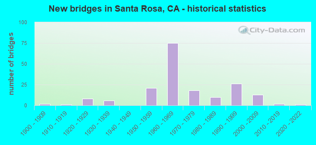
- New bridges - historical statistics
- 21900-1909
- 11910-1919
- 81920-1929
- 61930-1939
- 211950-1959
- 751960-1969
- 181970-1979
- 101980-1989
- 261990-1999
- 132000-2009
- 22010-2019
- 12020-2022

- Reconstructed bridges - Historical Statistics
- 21940-1949
- 41950-1959
- 41960-1969
- 31970-1979
- 41980-1989
- 11990-1999
- 42000-2009


- Bridge Condition - Deck
- 39.3%Good
- 7.5%Satisfactory
- 52.3%Fair
- 0.9%Poor

- Bridge Condition - Superstructure
- 75.2%Good
- 3.4%Satisfactory
- 19.7%Fair
- 1.7%Poor

- Bridge Condition - Substructure
- 91.5%Good
- 8.5%Fair

- Bridge Condition - Channel
- 3.8%Excellent
- 33.3%Very good
- 48.6%Good
- 14.3%Satisfactory

- Bridge Condition - Culverts
- 61.3%Good
- 35.5%Satisfactory
- 3.2%Fair
Find on map >> Show street view
Structure Number: 20 002, Location: 04-SON-121-1.53 (Lat: 38.169958, Lng: -122.457358), Route carried "on" structure: State highway 121, Year Built: 1996, Status: Open, Structure Length: 2.17m (7.12ft), Average Daily Traffic: 16,150 (year 2009), Truck Traffic: 8%, Average Future Daily Traffic: 22,978 (year 2036), Design Load: HS 20+Mod, Features Intersected: TOLAY CREEK
Minimum Vertical Clearance: 30+ m (98+ ft), Kilometerpoint: 1.530, Lanes on structure: 2, Base Highway Network: Yes (Inventory Route: 1, Subroute: 1), Owner: State Highway Agency, Approaching Roadway Width: 12.5m (41.0ft), Skew: 1 degrees, Material/Design: Concrete continuous, Design/Construction: Slab, Number Of Spans In Main Unit: 2, Length of Maximum Span: 10.8m (35.4ft), Curb-To-Curb Width: 12.2m (40.0ft), Out-to-Out Width: 13.3m (43.6ft)
Condition: Deck: Good, Superstructure: Good, Substructure: Good, Channel: Excellent, Operating Rating: 54.1 metric tons, Method Used To Determine Operating Rating: Assigned rating based on Load Factor Design (LFD) reported in metric tons, Inventory Rating: 32.4 metric tons, Method Used To Determine Inventory Rating: Assigned rating based on Load Factor Design (LFD) reported in metric tons, Structural Evaluation: Better than present minimum criteria, Deck Geometry: Somewhat better than minimum adequacy, Waterway Adequacy: Equal to present desirable criteria, Approach Roadway Alignment: Equal to present desirable criteria, Designated Inspection Frequency: Every 48 months, Inspection Date: October 2018, Deck Structure Type: Concrete Cast-file-Place
Find on map >> Show street view
Structure Number: 20 0028, Location: 04-SON-012-21.45 (Lat: 38.457189, Lng: -122.630803), Route carried "on" structure: State highway 12, Year Built: 1974, Status: Open, Structure Length: 2.07m (6.79ft), Average Daily Traffic: 41,250 (year 2012), Truck Traffic: 4%, Average Future Daily Traffic: 43,100 (year 2037), Design Load: HS 20+Mod, Features Intersected: SANTA ROSA CREEK
Minimum Vertical Clearance: 30+ m (98+ ft), Kilometerpoint: 21.450, Lanes on structure: 4, Base Highway Network: Yes (, Subroute: 1), Owner: State Highway Agency, Approaching Roadway Width: 25.0m (82.0ft), Skew: 23 degrees, Material/Design: Concrete, Design/Construction: Tee Beam, Number Of Spans In Main Unit: 1, Length of Maximum Span: 20.1m (65.9ft), Curb-To-Curb Width: 19.5m (64.0ft), Out-to-Out Width: 25.6m (84.0ft)
Condition: Deck: Fair, Superstructure: Good, Substructure: Good, Channel: Good, Operating Rating: 63.2 metric tons, Method Used To Determine Operating Rating: Load and Resistance Factor Rating (LRFR) rating reported by rating factor(RF) method using HL-93 loadings, Inventory Rating: 46.0 metric tons, Method Used To Determine Inventory Rating: Load and Resistance Factor Rating (LRFR) rating reported by rating factor(RF) method using HL-93 loadings, Structural Evaluation: Better than present minimum criteria, Deck Geometry: Better than present minimum criteria, Waterway Adequacy: Equal to present desirable criteria, Approach Roadway Alignment: Equal to present desirable criteria, Designated Inspection Frequency: Every 24 months, Inspection Date: September 2020, Deck Structure Type: Concrete Cast-file-Place
Find on map >> Show street view
Structure Number: 20 0029, Location: 04-SON-012-18.37-SRO (Lat: 38.454658, Lng: -122.680458), Route carried "on" structure: State highway 12, Year Built: 1962, Status: Open, Structure Length: 2.93m (9.61ft), Average Daily Traffic: 41,250 (year 2009), Truck Traffic: 4%, Average Future Daily Traffic: 44,410 (year 2037), Design Load: HS 20, Features Intersected: BRUSH CREEK
Minimum Vertical Clearance: 30+ m (98+ ft), Kilometerpoint: 18.370, Lanes on structure: 4, Base Highway Network: Yes (, Subroute: 1), Owner: State Highway Agency, Approaching Roadway Width: 22.3m (73.2ft), Skew: 29 degrees, Material/Design: Concrete continuous, Design/Construction: Tee Beam, Number Of Spans In Main Unit: 3, Length of Maximum Span: 11.0m (36.1ft), Curb or Sidewalk Widths: Left: 1.5m (4.9ft), Right: 0.0m, Curb-To-Curb Width: 22.8m (74.8ft), Out-to-Out Width: 25.0m (82.0ft)
Condition: Deck: Fair, Superstructure: Good, Substructure: Good, Channel: Good, Operating Rating: 39.5 metric tons, Method Used To Determine Operating Rating: Load and Resistance Factor Rating (LRFR) rating reported by rating factor(RF) method using HL-93 loadings, Inventory Rating: 30.5 metric tons, Method Used To Determine Inventory Rating: Load and Resistance Factor Rating (LRFR) rating reported by rating factor(RF) method using HL-93 loadings, Structural Evaluation: Better than present minimum criteria, Deck Geometry: Superior to present desirable criteria, Waterway Adequacy: Equal to present desirable criteria, Approach Roadway Alignment: Equal to present minimum criteria, Designated Inspection Frequency: Every 24 months, Inspection Date: September 2020, Deck Structure Type: Concrete Cast-file-Place
Find on map >> Show street view
Structure Number: 20 0103, Location: 04-SON-116-29.83 (Lat: 38.371033, Lng: -122.786817), Route carried "on" structure: State highway 116, Year Built: 1938, Status: Open, Structure Length: 1.04m (3.41ft), Average Daily Traffic: 16,550 (year 2014), Truck Traffic: 4%, Average Future Daily Traffic: 24,100 (year 2038), Features Intersected: BLUCHER CREEK
Minimum Vertical Clearance: 30+ m (98+ ft), Kilometerpoint: 29.830, Lanes on structure: 2, Base Highway Network: Yes (Inventory Route: 1, Subroute: 1), Owner: State Highway Agency, Approaching Roadway Width: 11.0m (36.1ft), Material/Design: Concrete continuous, Design/Construction: Culvert, Number Of Spans In Main Unit: 3, Length of Maximum Span: 3.0m (9.8ft), Curb-To-Curb Width: 11.4m (37.4ft), Out-to-Out Width: 12.0m (39.4ft)
Condition: Channel: Satisfactory, Culverts: Good, Operating Rating: 40.5 metric tons, Method Used To Determine Operating Rating: Field evaluation and documented engineering judgment, Inventory Rating: 24.3 metric tons, Method Used To Determine Inventory Rating: Field evaluation and documented engineering judgment, Structural Evaluation: Equal to present minimum criteria, Deck Geometry: Meets minimum limits, Waterway Adequacy: Equal to present minimum criteria, Approach Roadway Alignment: Equal to present desirable criteria, Designated Inspection Frequency: Every 24 months, Inspection Date: October 2020, Deck Structure Type: Concrete Cast-file-Place, Wearing Surface/Protective System: Wearing Surface: Bituminous
Find on map >> Show street view
Structure Number: 20 011, Location: 04-SON-116-37.49 (Lat: 38.226728, Lng: -122.576244), Route carried "on" structure: State highway 116, Year Built: 1972, Status: Open, Structure Length: 1.89m (6.20ft), Average Daily Traffic: 12,000 (year 2012), Average Future Daily Traffic: 24,500 (year 2037), Design Load: HS 20, Features Intersected: ELLIS CREEK
Minimum Vertical Clearance: 30+ m (98+ ft), Kilometerpoint: 37.490, Lanes on structure: 2, Base Highway Network: Yes (Inventory Route: 1, Subroute: 1), Owner: State Highway Agency, Approaching Roadway Width: 12.2m (40.0ft), Skew: 3 degrees, Material/Design: Concrete continuous, Design/Construction: Slab, Number Of Spans In Main Unit: 3, Length of Maximum Span: 7.5m (24.6ft), Curb-To-Curb Width: 12.2m (40.0ft), Out-to-Out Width: 12.8m (42.0ft)
Condition: Deck: Good, Superstructure: Good, Substructure: Good, Channel: Satisfactory, Operating Rating: 79.7 metric tons, Method Used To Determine Operating Rating: Load Factor (LF), Inventory Rating: 48.0 metric tons, Method Used To Determine Inventory Rating: Load Factor (LF), Structural Evaluation: Better than present minimum criteria, Deck Geometry: Somewhat better than minimum adequacy, Waterway Adequacy: Better than present minimum criteria, Approach Roadway Alignment: Equal to present desirable criteria, Designated Inspection Frequency: Every 48 months, Inspection Date: October 2020, Deck Structure Type: Concrete Cast-file-Place, Wearing Surface/Protective System: Wearing Surface: Bituminous
Find on map >> Show street view
Structure Number: 20 0112, Location: 04-SON-101-20.09-SRO (Lat: 38.437347, Lng: -122.717839), Route carried "on" structure: US 101, Year Built: 1968, Year Reconstructed: 2009, Status: Open, Structure Length: 23.10m (75.79ft), Average Daily Traffic: 96,000 (year 2016), Truck Traffic: 6%, Average Future Daily Traffic: 190,669 (year 2038), Design Load: HS 20, Features Intersected: 3RD ST, 4TH ST, & 5TH ST
Minimum Vertical Clearance: 30+ m (98+ ft), Kilometerpoint: 20.090, Lanes on structure: 8, Lanes under structure: 10, Base Highway Network: Yes (Inventory Route: 1, Subroute: 1), Owner: State Highway Agency, Approaching Roadway Width: 41.3m (135.5ft), Skew: 30 degrees, Material/Design: Concrete continuous, Design/Construction: Box Beam or Girders - Multiple, Number Of Spans In Main Unit: 10, Length of Maximum Span: 27.4m (89.9ft), Curb-To-Curb Width: 41.3m (135.5ft), Out-to-Out Width: 42.3m (138.8ft)
Condition: Deck: Fair, Superstructure: Good, Substructure: Good, Operating Rating: 48.0 metric tons, Method Used To Determine Operating Rating: Load and Resistance Factor Rating (LRFR) rating reported by rating factor(RF) method using HL-93 loadings, Inventory Rating: 36.9 metric tons, Method Used To Determine Inventory Rating: Load and Resistance Factor Rating (LRFR) rating reported by rating factor(RF) method using HL-93 loadings, Structural Evaluation: Better than present minimum criteria, Deck Geometry: Superior to present desirable criteria, Underclear: Equal to present minimum criteria, Approach Roadway Alignment: Equal to present desirable criteria, Designated Inspection Frequency: Every 24 months, Inspection Date: August 2020, Deck Structure Type: Concrete Cast-file-Place
Find on map >> Show street view
Structure Number: 20 013, Location: 04-SON-128-9.75 (Lat: 38.684339, Lng: -122.842675), Route carried "on" structure: State highway 128, Year Built: 1983, Status: Open, Structure Length: 0.79m (2.59ft), Average Daily Traffic: 2,750 (year 2014), Truck Traffic: 6%, Average Future Daily Traffic: 3,243 (year 2038), Design Load: HS 20+Mod, Features Intersected: GIRD CREEK
Minimum Vertical Clearance: 30+ m (98+ ft), Kilometerpoint: 9.750, Lanes on structure: 2, Base Highway Network: Yes (Inventory Route: 1, Subroute: 1), Owner: State Highway Agency, Approaching Roadway Width: 6.4m (21.0ft), Material/Design: Concrete continuous, Design/Construction: Culvert, Number Of Spans In Main Unit: 2, Length of Maximum Span: 3.7m (12.1ft), Curb or Sidewalk Widths: Left: 0.2m (0.7ft), Right: 0.2m (0.7ft), Curb-To-Curb Width: 9.8m (32.2ft), Out-to-Out Width: 10.8m (35.4ft)
Condition: Channel: Very good, Culverts: Good, Operating Rating: 54.1 metric tons, Method Used To Determine Operating Rating: Field evaluation and documented engineering judgment, Inventory Rating: 32.4 metric tons, Method Used To Determine Inventory Rating: Field evaluation and documented engineering judgment, Structural Evaluation: Better than present minimum criteria, Deck Geometry: Meets minimum limits, Waterway Adequacy: Better than present minimum criteria, Approach Roadway Alignment: High priority of corrective action, Designated Inspection Frequency: Every 48 months, Inspection Date: October 2018, Deck Structure Type: Concrete Cast-file-Place, Wearing Surface/Protective System: Wearing Surface: Bituminous
Find on map >> Show street view
Structure Number: 20 0134, Location: 04-SON-101-20.48-SRO (Lat: 38.442275, Lng: -122.721242), Route carried "on" structure: US 101, Year Built: 1968, Year Reconstructed: 2009, Status: Open, Structure Length: 4.60m (15.09ft), Average Daily Traffic: 96,000 (year 2016), Truck Traffic: 6%, Average Future Daily Traffic: 190,669 (year 2038), Design Load: HS 20, Features Intersected: NINTH STREET
Minimum Vertical Clearance: 30+ m (98+ ft), Kilometerpoint: 20.480, Lanes on structure: 8, Lanes under structure: 2, Base Highway Network: Yes (Inventory Route: 1, Subroute: 1), Owner: State Highway Agency, Approaching Roadway Width: 40.8m (133.9ft), Skew: 31 degrees, Material/Design: Concrete continuous, Design/Construction: Box Beam or Girders - Multiple, Number Of Spans In Main Unit: 3, Length of Maximum Span: 27.7m (90.9ft), Curb-To-Curb Width: 40.0m (131.2ft), Out-to-Out Width: 41.5m (136.2ft)
Condition: Deck: Fair, Superstructure: Good, Substructure: Good, Operating Rating: 54.1 metric tons, Method Used To Determine Operating Rating: Assigned rating based on Load Factor Design (LFD) reported in metric tons, Inventory Rating: 32.4 metric tons, Method Used To Determine Inventory Rating: Assigned rating based on Load Factor Design (LFD) reported in metric tons, Structural Evaluation: Better than present minimum criteria, Deck Geometry: Superior to present desirable criteria, Underclear: Equal to present minimum criteria, Approach Roadway Alignment: Equal to present desirable criteria, Designated Inspection Frequency: Every 24 months, Inspection Date: August 2020, Deck Structure Type: Concrete Cast-file-Place
Find on map >> Show street view
Structure Number: 20 0171K, Location: 04-SON-101-15.53 (Lat: 38.371756, Lng: -122.714436), Route carried "on" structure: Ramp US 101, Year Built: 1957, Status: Open, Structure Length: 4.85m (15.91ft), Average Daily Traffic: 3,000 (year 2016), Truck Traffic: 2%, Average Future Daily Traffic: 8,534 (year 2038), Design Load: HS 20, Features Intersected: U.S. HIGHWAY 101
Minimum Vertical Clearance: 30+ m (98+ ft), Kilometerpoint: 15.530, Lanes on structure: 1, Lanes under structure: 5, Owner: State Highway Agency, Approaching Roadway Width: 6.7m (22.0ft), Skew: 3 degrees, Material/Design: Concrete continuous, Design/Construction: Box Beam or Girders - Multiple, Number Of Spans In Main Unit: 2, Length of Maximum Span: 23.5m (77.1ft), Curb or Sidewalk Widths: Left: 0.6m (2.0ft), Right: 0.6m (2.0ft), Curb-To-Curb Width: 6.7m (22.0ft), Out-to-Out Width: 8.3m (27.2ft)
Condition: Deck: Fair, Superstructure: Poor, Substructure: Good, Operating Rating: 44.7 metric tons, Method Used To Determine Operating Rating: Load and Resistance Factor Rating (LRFR) rating reported by rating factor(RF) method using HL-93 loadings, Inventory Rating: 32.7 metric tons, Method Used To Determine Inventory Rating: Load and Resistance Factor Rating (LRFR) rating reported by rating factor(RF) method using HL-93 loadings, Structural Evaluation: Meets minimum limits, Deck Geometry: Equal to present minimum criteria, Underclear: High priority of corrective action, Approach Roadway Alignment: Equal to present minimum criteria, Length Of Structure Improvement: 4.85m (15.91ft), Designated Inspection Frequency: Every 24 months, Inspection Date: April 2020, Bridge Improvement Cost: $417,000, Roadway Improvement Cost: $83,000, Total Project Cost: $700,000 ( Estimate for 2019), Deck Structure Type: Concrete Cast-file-Place
Find on map >> Show street view
Structure Number: 20 0172, Location: 04-SON-101-16.54 (Lat: 38.386222, Lng: -122.716558), Route carried "on" structure: County highway , Year Built: 1957, Status: Open, Structure Length: 6.34m (20.80ft), Average Daily Traffic: 1,100 (year 2014), Truck Traffic: 2%, Average Future Daily Traffic: 4,080 (year 2038), Design Load: HS 20, Features Intersected: U.S. HIGHWAY 101 & RAMPS, Facility Carried by Structure: TODD ROAD
Minimum Vertical Clearance: 30+ m (98+ ft), Kilometerpoint: 0.000, Lanes on structure: 2, Lanes under structure: 6, Owner: State Highway Agency, Approaching Roadway Width: 11.9m (39.0ft), Material/Design: Concrete continuous, Design/Construction: Box Beam or Girders - Multiple, Number Of Spans In Main Unit: 4, Length of Maximum Span: 22.9m (75.1ft), Curb or Sidewalk Widths: Left: 0.6m (2.0ft), Right: 1.6m (5.2ft), Curb-To-Curb Width: 7.9m (25.9ft), Out-to-Out Width: 10.0m (32.8ft)
Condition: Deck: Fair, Superstructure: Fair, Substructure: Good, Operating Rating: 63.2 metric tons, Method Used To Determine Operating Rating: Load Factor (LF), Inventory Rating: 37.6 metric tons, Method Used To Determine Inventory Rating: Load Factor (LF), Structural Evaluation: Somewhat better than minimum adequacy, Deck Geometry: Meets minimum limits, Underclear: Meets minimum limits, Approach Roadway Alignment: Equal to present desirable criteria, Designated Inspection Frequency: Every 24 months, Inspection Date: August 2020, Deck Structure Type: Concrete Cast-file-Place
Find on map >> Show street view
Structure Number: 20 0173, Location: 04-SON-101-19.00 (Lat: 38.421775, Lng: -122.715700), Route carried "on" structure: County highway , Year Built: 1957, Status: Open, Structure Length: 7.50m (24.61ft), Average Daily Traffic: 7,500 (year 2014), Truck Traffic: 3%, Average Future Daily Traffic: 10,617 (year 2038), Design Load: HS 20, Features Intersected: U.S. HIGHWAY 101, Facility Carried by Structure: BAKER AVENUE
Minimum Vertical Clearance: 30+ m (98+ ft), Kilometerpoint: 0.000, Lanes on structure: 2, Lanes under structure: 5, Owner: State Highway Agency, Approaching Roadway Width: 11.3m (37.1ft), Skew: 4 degrees, Material/Design: Concrete continuous, Design/Construction: Box Beam or Girders - Multiple, Number Of Spans In Main Unit: 4, Length of Maximum Span: 29.0m (95.1ft), Curb or Sidewalk Widths: Left: 0.6m (2.0ft), Right: 1.6m (5.2ft), Curb-To-Curb Width: 8.5m (27.9ft), Out-to-Out Width: 10.6m (34.8ft)
Condition: Deck: Fair, Superstructure: Fair, Substructure: Good, Operating Rating: 54.1 metric tons, Method Used To Determine Operating Rating: Assigned rating based on Load Factor Design (LFD) reported in metric tons, Inventory Rating: 32.4 metric tons, Method Used To Determine Inventory Rating: Assigned rating based on Load Factor Design (LFD) reported in metric tons, Structural Evaluation: Somewhat better than minimum adequacy, Deck Geometry: Meets minimum limits, Underclear: High priority of corrective action, Approach Roadway Alignment: Equal to present desirable criteria, Designated Inspection Frequency: Every 24 months, Inspection Date: August 2020, Deck Structure Type: Concrete Cast-file-Place
Find on map >> Show street view
Structure Number: 20 0176, Location: 04-SON-101-18.49 (Lat: 38.414461, Lng: -122.716406), Route carried "on" structure: County highway , Year Built: 1957, Status: Open, Structure Length: 7.07m (23.20ft), Average Daily Traffic: 5,000 (year 2014), Truck Traffic: 3%, Average Future Daily Traffic: 5,273 (year 2038), Design Load: HS 20, Features Intersected: U.S. HIGHWAY 101 & RAMPS, Facility Carried by Structure: HEARN AVENUE
Minimum Vertical Clearance: 30+ m (98+ ft), Kilometerpoint: 0.000, Lanes on structure: 2, Lanes under structure: 8, Owner: State Highway Agency, Approaching Roadway Width: 12.2m (40.0ft), Skew: 1 degrees, Material/Design: Concrete continuous, Design/Construction: Box Beam or Girders - Multiple, Number Of Spans In Main Unit: 4, Length of Maximum Span: 23.8m (78.1ft), Curb or Sidewalk Widths: Left: 0.6m (2.0ft), Right: 1.6m (5.2ft), Curb-To-Curb Width: 7.9m (25.9ft), Out-to-Out Width: 10.0m (32.8ft)
Condition: Deck: Satisfactory, Superstructure: Good, Substructure: Good, Operating Rating: 93.0 metric tons, Method Used To Determine Operating Rating: Load Factor (LF), Inventory Rating: 56.7 metric tons, Method Used To Determine Inventory Rating: Load Factor (LF), Structural Evaluation: Better than present minimum criteria, Deck Geometry: High priority of corrective action, Underclear: High priority of corrective action, Approach Roadway Alignment: Equal to present desirable criteria, Designated Inspection Frequency: Every 48 months, Inspection Date: August 2018, Deck Structure Type: Concrete Cast-file-Place
Find on map >> Show street view
Structure Number: 20 0179, Location: 04-SON-101-22.81-SRO (Lat: 38.474700, Lng: -122.731619), Route carried "on" structure: City street , Year Built: 1962, Status: Open, Structure Length: 8.50m (27.89ft), Average Daily Traffic: 16,000 (year 2016), Truck Traffic: 3%, Average Future Daily Traffic: 19,380 (year 2038), Design Load: HS 20+Mod, Features Intersected: U.S. HIGHWAY 101, Facility Carried by Structure: INDUSTRIAL DR
Minimum Vertical Clearance: 30+ m (98+ ft), Kilometerpoint: 0.000, Lanes on structure: 2, Lanes under structure: 6, Base Highway Network: Yes, Owner: State Highway Agency, Approaching Roadway Width: 9.8m (32.2ft), Material/Design: Concrete continuous, Design/Construction: Box Beam or Girders - Multiple, Number Of Spans In Main Unit: 4, Length of Maximum Span: 27.7m (90.9ft), Curb or Sidewalk Widths: Left: 1.5m (4.9ft), Right: 0.0m, Curb-To-Curb Width: 9.8m (32.2ft), Out-to-Out Width: 12.3m (40.4ft)
Condition: Deck: Fair, Superstructure: Good, Substructure: Good, Operating Rating: 39.2 metric tons, Method Used To Determine Operating Rating: Load and Resistance Factor Rating (LRFR) rating reported by rating factor(RF) method using HL-93 loadings, Inventory Rating: 30.1 metric tons, Method Used To Determine Inventory Rating: Load and Resistance Factor Rating (LRFR) rating reported by rating factor(RF) method using HL-93 loadings, Structural Evaluation: Better than present minimum criteria, Deck Geometry: Meets minimum limits, Underclear: Meets minimum limits, Approach Roadway Alignment: Better than present minimum criteria, Designated Inspection Frequency: Every 24 months, Inspection Date: August 2020, Deck Structure Type: Concrete Cast-file-Place
Find on map >> Show street view
Structure Number: 20 0196, Location: 04-SON-101-18.88 (Lat: 38.420381, Lng: -122.715375), Route carried "on" structure: US 101, Year Built: 1957, Status: Open, Structure Length: 0.67m (2.20ft), Average Daily Traffic: 92,000 (year 2016), Truck Traffic: 6%, Average Future Daily Traffic: 165,675 (year 2037), Features Intersected: COLGAN CREEK
Minimum Vertical Clearance: 30+ m (98+ ft), Kilometerpoint: 18.880, Lanes on structure: 7, Base Highway Network: Yes (Inventory Route: 1, Subroute: 1), Owner: State Highway Agency, Approaching Roadway Width: 38.4m (126.0ft), Skew: 32 degrees, Material/Design: Concrete continuous, Design/Construction: Culvert, Number Of Spans In Main Unit: 2, Length of Maximum Span: 3.0m (9.8ft)
Condition: Channel: Very good, Culverts: Satisfactory, Operating Rating: 54.1 metric tons, Method Used To Determine Operating Rating: Field evaluation and documented engineering judgment, Inventory Rating: 32.4 metric tons, Method Used To Determine Inventory Rating: Field evaluation and documented engineering judgment, Structural Evaluation: Equal to present minimum criteria, Waterway Adequacy: Equal to present minimum criteria, Approach Roadway Alignment: Equal to present desirable criteria, Designated Inspection Frequency: Every 24 months, Inspection Date: August 2020
Find on map >> Show street view
Structure Number: 20 0196K, Location: 04-SON-101-18.91 (Lat: 38.420244, Lng: -122.716294), Route carried "on" structure: Bypass US 101, Year Built: 1957, Status: Open, Structure Length: 0.67m (2.20ft), Average Daily Traffic: 2,400 (year 2014), Truck Traffic: 2%, Average Future Daily Traffic: 2,610 (year 2038), Features Intersected: COLGAN CREEK
Minimum Vertical Clearance: 30+ m (98+ ft), Kilometerpoint: 18.910, Lanes on structure: 2, Base Highway Network: Yes (Inventory Route: 1, Subroute: 1), Owner: State Highway Agency, Approaching Roadway Width: 7.9m (25.9ft), Skew: 1 degrees, Material/Design: Concrete continuous, Design/Construction: Culvert, Number Of Spans In Main Unit: 2, Length of Maximum Span: 3.0m (9.8ft)
Condition: Channel: Very good, Culverts: Good, Operating Rating: 54.1 metric tons, Method Used To Determine Operating Rating: Field evaluation and documented engineering judgment, Inventory Rating: 32.4 metric tons, Method Used To Determine Inventory Rating: Field evaluation and documented engineering judgment, Structural Evaluation: Better than present minimum criteria, Waterway Adequacy: Equal to present minimum criteria, Approach Roadway Alignment: Equal to present desirable criteria, Designated Inspection Frequency: Every 24 months, Inspection Date: August 2020
Find on map >> Show street view
Structure Number: 20 0202, Location: 04-SON-101-27.62 (Lat: 38.525781, Lng: -122.790489), Route carried "on" structure: City street , Year Built: 1962, Status: Open, Structure Length: 7.56m (24.80ft), Average Daily Traffic: 3,000 (year 2018), Truck Traffic: 7%, Average Future Daily Traffic: 5,135 (year 2037), Design Load: HS 20, Features Intersected: U.S. HIGHWAY 101, Facility Carried by Structure: SHILOH ROAD
Minimum Vertical Clearance: 30+ m (98+ ft), Kilometerpoint: 0.000, Lanes on structure: 2, Lanes under structure: 6, Owner: State Highway Agency, Approaching Roadway Width: 11.6m (38.1ft), Skew: 3 degrees, Material/Design: Concrete continuous, Design/Construction: Box Beam or Girders - Multiple, Number Of Spans In Main Unit: 4, Length of Maximum Span: 25.6m (84.0ft), Curb or Sidewalk Widths: Left: 1.5m (4.9ft), Right: 0.0m, Curb-To-Curb Width: 9.8m (32.2ft), Out-to-Out Width: 12.3m (40.4ft)
Condition: Deck: Fair, Superstructure: Good, Substructure: Good, Operating Rating: 42.4 metric tons, Method Used To Determine Operating Rating: Load and Resistance Factor Rating (LRFR) rating reported by rating factor(RF) method using HL-93 loadings, Inventory Rating: 30.5 metric tons, Method Used To Determine Inventory Rating: Load and Resistance Factor Rating (LRFR) rating reported by rating factor(RF) method using HL-93 loadings, Structural Evaluation: Better than present minimum criteria, Deck Geometry: Meets minimum limits, Underclear: Meets minimum limits, Approach Roadway Alignment: Superior to present desirable criteria, Designated Inspection Frequency: Every 24 months, Inspection Date: August 2020, Deck Structure Type: Concrete Cast-file-Place
Find on map >> Show street view
Structure Number: 20 0203L, Location: 04-SON-012-R15.30 (Lat: 38.433058, Lng: -122.726472), Route carried "on" structure: State highway 12, Year Built: 1964, Status: Open, Structure Length: 4.51m (14.80ft), Average Daily Traffic: 36,500 (year 2016), Truck Traffic: 4%, Average Future Daily Traffic: 51,800 (year 2036), Design Load: HS 20, Features Intersected: DUTTON AVE
Minimum Vertical Clearance: 30+ m (98+ ft), Kilometerpoint: 15.300, Lanes on structure: 2, Lanes under structure: 6, Base Highway Network: Yes (, Subroute: 1), Owner: State Highway Agency, Approaching Roadway Width: 11.3m (37.1ft), Material/Design: Concrete continuous, Design/Construction: Box Beam or Girders - Multiple, Number Of Spans In Main Unit: 3, Length of Maximum Span: 26.8m (87.9ft), Curb-To-Curb Width: 11.3m (37.1ft), Out-to-Out Width: 12.2m (40.0ft)
Condition: Deck: Satisfactory, Superstructure: Good, Substructure: Good, Operating Rating: 48.3 metric tons, Method Used To Determine Operating Rating: Load and Resistance Factor Rating (LRFR) rating reported by rating factor(RF) method using HL-93 loadings, Inventory Rating: 34.7 metric tons, Method Used To Determine Inventory Rating: Load and Resistance Factor Rating (LRFR) rating reported by rating factor(RF) method using HL-93 loadings, Structural Evaluation: Better than present minimum criteria, Deck Geometry: Somewhat better than minimum adequacy, Underclear: Somewhat better than minimum adequacy, Approach Roadway Alignment: Equal to present desirable criteria, Designated Inspection Frequency: Every 48 months, Inspection Date: September 2018, Deck Structure Type: Concrete Cast-file-Place
Find on map >> Show street view
Structure Number: 20 0203R, Location: 04-SON-012-R15.30 (Lat: 38.432864, Lng: -122.726403), Route carried "on" structure: State highway 12, Year Built: 1964, Status: Open, Structure Length: 4.51m (14.80ft), Average Daily Traffic: 36,500 (year 2014), Truck Traffic: 4%, Average Future Daily Traffic: 51,800 (year 2038), Design Load: HS 20, Features Intersected: DUTTON AVE
Minimum Vertical Clearance: 30+ m (98+ ft), Kilometerpoint: 15.300, Lanes on structure: 2, Lanes under structure: 6, Base Highway Network: Yes (, Subroute: 1), Owner: State Highway Agency, Approaching Roadway Width: 11.3m (37.1ft), Material/Design: Concrete continuous, Design/Construction: Box Beam or Girders - Multiple, Number Of Spans In Main Unit: 3, Length of Maximum Span: 26.8m (87.9ft), Curb-To-Curb Width: 11.3m (37.1ft), Out-to-Out Width: 12.3m (40.4ft)
Condition: Deck: Satisfactory, Superstructure: Good, Substructure: Good, Operating Rating: 48.3 metric tons, Method Used To Determine Operating Rating: Load and Resistance Factor Rating (LRFR) rating reported by rating factor(RF) method using HL-93 loadings, Inventory Rating: 34.7 metric tons, Method Used To Determine Inventory Rating: Load and Resistance Factor Rating (LRFR) rating reported by rating factor(RF) method using HL-93 loadings, Structural Evaluation: Better than present minimum criteria, Deck Geometry: Somewhat better than minimum adequacy, Underclear: Meets minimum limits, Approach Roadway Alignment: Equal to present desirable criteria, Designated Inspection Frequency: Every 48 months, Inspection Date: September 2018, Deck Structure Type: Concrete Cast-file-Place
Find on map >> Show street view
Structure Number: 20 0204L, Location: 04-SON-012-R15.56-SRO (Lat: 38.433397, Lng: -122.721778), Route carried "on" structure: State highway 12, Year Built: 1964, Status: Open, Structure Length: 6.68m (21.92ft), Average Daily Traffic: 36,500 (year 2016), Truck Traffic: 4%, Average Future Daily Traffic: 53,021 (year 2038), Design Load: HS 20+Mod, Features Intersected: NWP RR
Minimum Vertical Clearance: 30+ m (98+ ft), Kilometerpoint: 15.560, Lanes on structure: 3, Base Highway Network: Yes (, Subroute: 1), Owner: State Highway Agency, Approaching Roadway Width: 12.5m (41.0ft), Skew: 1 degrees, Material/Design: Prestressed concrete, Design/Construction: Stringer/Multi-beam, Number Of Spans In Main Unit: 2, Number Of Approach Spans: 1, Length of Maximum Span: 27.4m (89.9ft), Curb-To-Curb Width: 12.5m (41.0ft), Out-to-Out Width: 14.0m (45.9ft)
Condition: Deck: Fair, Superstructure: Good, Substructure: Good, Operating Rating: 32.1 metric tons, Method Used To Determine Operating Rating: Load and Resistance Factor Rating (LRFR) rating reported by rating factor(RF) method using HL-93 loadings, Inventory Rating: 24.9 metric tons, Method Used To Determine Inventory Rating: Load and Resistance Factor Rating (LRFR) rating reported by rating factor(RF) method using HL-93 loadings, Structural Evaluation: Equal to present minimum criteria, Deck Geometry: Meets minimum limits, Underclear: Somewhat better than minimum adequacy, Approach Roadway Alignment: Equal to present desirable criteria, Designated Inspection Frequency: Every 24 months, Inspection Date: September 2020, Deck Structure Type: Concrete Cast-file-Place
Find on map >> Show street view
Structure Number: 20 0204R, Location: 04-SON-012-R15.56-SRO (Lat: 38.433167, Lng: -122.721883), Route carried "on" structure: State highway 12, Year Built: 1964, Year Reconstructed: 2008, Status: Open, Structure Length: 7.07m (23.20ft), Average Daily Traffic: 36,500 (year 2014), Truck Traffic: 4%, Average Future Daily Traffic: 53,021 (year 2038), Design Load: HS 20+Mod, Features Intersected: NWP RR
Minimum Vertical Clearance: 30+ m (98+ ft), Kilometerpoint: 15.560, Lanes on structure: 3, Base Highway Network: Yes (, Subroute: 1), Owner: State Highway Agency, Approaching Roadway Width: 15.5m (50.9ft), Skew: 1 degrees, Material/Design: Prestressed concrete, Design/Construction: Stringer/Multi-beam, Number Of Spans In Main Unit: 2, Number Of Approach Spans: 2, Length of Maximum Span: 24.4m (80.1ft), Curb-To-Curb Width: 15.5m (50.9ft), Out-to-Out Width: 16.5m (54.1ft)
Condition: Deck: Fair, Superstructure: Good, Substructure: Good, Operating Rating: 50.5 metric tons, Method Used To Determine Operating Rating: Load Factor (LF), Inventory Rating: 30.5 metric tons, Method Used To Determine Inventory Rating: Load Factor (LF), Structural Evaluation: Better than present minimum criteria, Deck Geometry: Somewhat better than minimum adequacy, Underclear: Equal to present minimum criteria, Approach Roadway Alignment: Equal to present desirable criteria, Designated Inspection Frequency: Every 24 months, Inspection Date: September 2020, Deck Structure Type: Concrete Cast-file-Place
Find on map >> Show street view
Structure Number: 20 0205F, Location: 04-SON-101-19.82-SRO (Lat: 38.432922, Lng: -122.719169), Route carried "on" structure: Ramp US 101, Year Built: 1964, Status: Open, Structure Length: 4.60m (15.09ft), Average Daily Traffic: 6,300 (year 2016), Truck Traffic: 4%, Average Future Daily Traffic: 10,963 (year 2038), Features Intersected: OLIVE STREET
Minimum Vertical Clearance: 30+ m (98+ ft), Kilometerpoint: 19.820, Lanes on structure: 1, Lanes under structure: 2, Base Highway Network: Yes (Inventory Route: 1, Subroute: 1), Owner: State Highway Agency, Approaching Roadway Width: 6.7m (22.0ft), Skew: 1 degrees, Material/Design: Concrete continuous, Design/Construction: Box Beam or Girders - Multiple, Number Of Spans In Main Unit: 3, Length of Maximum Span: 20.1m (65.9ft), Curb or Sidewalk Widths: Left: 0.0m, Right: 0.6m (2.0ft), Curb-To-Curb Width: 6.7m (22.0ft), Out-to-Out Width: 8.1m (26.6ft)
Condition: Deck: Good, Superstructure: Good, Substructure: Good, Operating Rating: 35.6 metric tons, Method Used To Determine Operating Rating: Load and Resistance Factor Rating (LRFR) rating reported by rating factor(RF) method using HL-93 loadings, Inventory Rating: 25.6 metric tons, Method Used To Determine Inventory Rating: Load and Resistance Factor Rating (LRFR) rating reported by rating factor(RF) method using HL-93 loadings, Structural Evaluation: Equal to present minimum criteria, Deck Geometry: Equal to present minimum criteria, Underclear: Better than present minimum criteria, Approach Roadway Alignment: Equal to present desirable criteria, Designated Inspection Frequency: Every 24 months, Inspection Date: August 2020, Deck Structure Type: Concrete Cast-file-Place
Find on map >> Show street view
Structure Number: 20 0205G, Location: 04-SON-012-R15.70-SRO (Lat: 38.432400, Lng: -122.719258), Route carried "on" structure: Ramp State highway 12, Year Built: 1964, Year Reconstructed: 2009, Status: Open, Structure Length: 4.73m (15.52ft), Average Daily Traffic: 47,400 (year 2014), Truck Traffic: 4%, Average Future Daily Traffic: 56,261 (year 2038), Design Load: HS 20, Features Intersected: OLIVE STREET
Minimum Vertical Clearance: 30+ m (98+ ft), Kilometerpoint: 15.700, Lanes on structure: 2, Lanes under structure: 2, Base Highway Network: Yes (, Subroute: 1), Owner: State Highway Agency, Approaching Roadway Width: 11.4m (37.4ft), Skew: 2 degrees, Material/Design: Concrete continuous, Design/Construction: Box Beam or Girders - Multiple, Number Of Spans In Main Unit: 3, Length of Maximum Span: 20.7m (67.9ft), Curb or Sidewalk Widths: Left: 0.6m (2.0ft), Right: 0.0m, Curb-To-Curb Width: 11.4m (37.4ft), Out-to-Out Width: 13.0m (42.7ft)
Condition: Deck: Satisfactory, Superstructure: Good, Substructure: Good, Operating Rating: 79.1 metric tons, Method Used To Determine Operating Rating: Load Factor (LF), Inventory Rating: 47.6 metric tons, Method Used To Determine Inventory Rating: Load Factor (LF), Structural Evaluation: Better than present minimum criteria, Deck Geometry: Superior to present desirable criteria, Underclear: Better than present minimum criteria, Approach Roadway Alignment: Equal to present desirable criteria, Designated Inspection Frequency: Every 24 months, Inspection Date: September 2020, Deck Structure Type: Concrete Cast-file-Place
Find on map >> Show street view
Structure Number: 20 0205L, Location: 04-SON-012-R15.70-SRO (Lat: 38.432778, Lng: -122.719178), Route carried "on" structure: State highway 12, Year Built: 1964, Status: Open, Structure Length: 4.48m (14.70ft), Average Daily Traffic: 36,500 (year 2014), Truck Traffic: 4%, Average Future Daily Traffic: 53,021 (year 2038), Design Load: HS 20, Features Intersected: OLIVE STREET
Minimum Vertical Clearance: 30+ m (98+ ft), Kilometerpoint: 15.700, Lanes on structure: 2, Lanes under structure: 2, Base Highway Network: Yes (, Subroute: 1), Owner: State Highway Agency, Approaching Roadway Width: 11.3m (37.1ft), Skew: 1 degrees, Material/Design: Concrete continuous, Design/Construction: Box Beam or Girders - Multiple, Number Of Spans In Main Unit: 3, Length of Maximum Span: 20.4m (66.9ft), Curb or Sidewalk Widths: Left: 0.0m, Right: 0.3m (1.0ft), Curb-To-Curb Width: 11.3m (37.1ft), Out-to-Out Width: 12.3m (40.4ft)
Condition: Deck: Good, Superstructure: Good, Substructure: Good, Operating Rating: 35.0 metric tons, Method Used To Determine Operating Rating: Load and Resistance Factor Rating (LRFR) rating reported by rating factor(RF) method using HL-93 loadings, Inventory Rating: 24.9 metric tons, Method Used To Determine Inventory Rating: Load and Resistance Factor Rating (LRFR) rating reported by rating factor(RF) method using HL-93 loadings, Structural Evaluation: Equal to present minimum criteria, Deck Geometry: Somewhat better than minimum adequacy, Underclear: Better than present minimum criteria, Approach Roadway Alignment: Equal to present desirable criteria, Designated Inspection Frequency: Every 24 months, Inspection Date: September 2020, Deck Structure Type: Concrete Cast-file-Place
Find on map >> Show street view
Structure Number: 20 0205R, Location: 04-SON-012-R15.70-SRO (Lat: 38.432569, Lng: -122.719222), Route carried "on" structure: State highway 12, Year Built: 1964, Status: Open, Structure Length: 4.48m (14.70ft), Average Daily Traffic: 36,500 (year 2016), Truck Traffic: 4%, Average Future Daily Traffic: 53,021 (year 2038), Design Load: HS 20, Features Intersected: OLIVE STREET
Minimum Vertical Clearance: 30+ m (98+ ft), Kilometerpoint: 15.700, Lanes on structure: 2, Lanes under structure: 2, Base Highway Network: Yes (, Subroute: 1), Owner: State Highway Agency, Approaching Roadway Width: 11.3m (37.1ft), Skew: 1 degrees, Material/Design: Concrete continuous, Design/Construction: Box Beam or Girders - Multiple, Number Of Spans In Main Unit: 3, Length of Maximum Span: 20.4m (66.9ft), Curb-To-Curb Width: 11.3m (37.1ft), Out-to-Out Width: 12.3m (40.4ft)
Condition: Deck: Good, Superstructure: Good, Substructure: Good, Operating Rating: 35.0 metric tons, Method Used To Determine Operating Rating: Load and Resistance Factor Rating (LRFR) rating reported by rating factor(RF) method using HL-93 loadings, Inventory Rating: 24.9 metric tons, Method Used To Determine Inventory Rating: Load and Resistance Factor Rating (LRFR) rating reported by rating factor(RF) method using HL-93 loadings, Structural Evaluation: Equal to present minimum criteria, Deck Geometry: Somewhat better than minimum adequacy, Underclear: Better than present minimum criteria, Approach Roadway Alignment: Equal to present desirable criteria, Designated Inspection Frequency: Every 24 months, Inspection Date: September 2020, Deck Structure Type: Concrete Cast-file-Place
Find on map >> Show street view
Structure Number: 20 0206L, Location: 04-SON-012-R15.90-SRO (Lat: 38.432097, Lng: -122.717714), Route carried "on" structure: State highway 12, Year Built: 1964, Status: Open, Structure Length: 3.47m (11.38ft), Average Daily Traffic: 31,500 (year 2016), Truck Traffic: 3%, Average Future Daily Traffic: 60,079 (year 2037), Design Load: HS 20, Features Intersected: S101-E12 CONNECTOR RAMP
Minimum Vertical Clearance: 30+ m (98+ ft), Kilometerpoint: 15.900, Lanes on structure: 2, Lanes under structure: 4, Base Highway Network: Yes (, Subroute: 1), Owner: State Highway Agency, Approaching Roadway Width: 10.4m (34.1ft), Skew: 3 degrees, Material/Design: Concrete continuous, Design/Construction: Tee Beam, Number Of Spans In Main Unit: 3, Length of Maximum Span: 14.3m (46.9ft), Curb or Sidewalk Widths: Left: 0.6m (2.0ft), Right: 0.0m, Curb-To-Curb Width: 12.5m (41.0ft), Out-to-Out Width: 14.0m (45.9ft)
Condition: Deck: Fair, Superstructure: Good, Substructure: Good, Operating Rating: 27.2 metric tons, Method Used To Determine Operating Rating: Load and Resistance Factor Rating (LRFR) rating reported by rating factor(RF) method using HL-93 loadings, Inventory Rating: 21.1 metric tons, Method Used To Determine Inventory Rating: Load and Resistance Factor Rating (LRFR) rating reported by rating factor(RF) method using HL-93 loadings, Structural Evaluation: Somewhat better than minimum adequacy, Deck Geometry: Better than present minimum criteria, Underclear: Somewhat better than minimum adequacy, Approach Roadway Alignment: Equal to present desirable criteria, Designated Inspection Frequency: Every 24 months, Inspection Date: September 2020, Deck Structure Type: Concrete Cast-file-Place
Find on map >> Show street view
Structure Number: 20 0206R, Location: 04-SON-012-R15.90-SRO (Lat: 38.431856, Lng: -122.717703), Route carried "on" structure: State highway 12, Year Built: 1964, Status: Open, Structure Length: 4.39m (14.40ft), Average Daily Traffic: 36,500 (year 2016), Truck Traffic: 4%, Average Future Daily Traffic: 51,800 (year 2038), Design Load: HS 20, Features Intersected: S101-E12 CONNECTOR RAMP
Minimum Vertical Clearance: 30+ m (98+ ft), Kilometerpoint: 15.900, Lanes on structure: 2, Lanes under structure: 1, Base Highway Network: Yes (, Subroute: 1), Owner: State Highway Agency, Approaching Roadway Width: 10.1m (33.1ft), Skew: 4 degrees, Material/Design: Concrete continuous, Design/Construction: Tee Beam, Number Of Spans In Main Unit: 3, Length of Maximum Span: 18.9m (62.0ft), Curb-To-Curb Width: 11.3m (37.1ft), Out-to-Out Width: 12.3m (40.4ft)
Condition: Deck: Fair, Superstructure: Good, Substructure: Good, Operating Rating: 31.8 metric tons, Method Used To Determine Operating Rating: Load and Resistance Factor Rating (LRFR) rating reported by rating factor(RF) method using HL-93 loadings, Inventory Rating: 24.3 metric tons, Method Used To Determine Inventory Rating: Load and Resistance Factor Rating (LRFR) rating reported by rating factor(RF) method using HL-93 loadings, Structural Evaluation: Equal to present minimum criteria, Deck Geometry: Somewhat better than minimum adequacy, Underclear: Meets minimum limits, Approach Roadway Alignment: Equal to present desirable criteria, Designated Inspection Frequency: Every 24 months, Inspection Date: September 2020, Deck Structure Type: Concrete Cast-file-Place
Find on map >> Show street view
Structure Number: 20 0207G, Location: 04-SON-012-R15.99-SRO (Lat: 38.431689, Lng: -122.717733), Route carried "on" structure: Ramp State highway 12, Year Built: 1964, Status: Open, Structure Length: 25.15m (82.51ft), Average Daily Traffic: 7,800 (year 2016), Truck Traffic: 3%, Average Future Daily Traffic: 10,442 (year 2037), Design Load: HS 20, Features Intersected: SR 12 & US 101
Minimum Vertical Clearance: 30+ m (98+ ft), Kilometerpoint: 15.990, Lanes on structure: 1, Lanes under structure: 12, Base Highway Network: Yes (, Subroute: 1), Owner: State Highway Agency, Approaching Roadway Width: 6.7m (22.0ft), Material/Design: Concrete continuous, Design/Construction: Box Beam or Girders - Multiple, Number Of Spans In Main Unit: 8, Length of Maximum Span: 38.7m (127.0ft), Curb or Sidewalk Widths: Left: 0.6m (2.0ft), Right: 0.0m, Curb-To-Curb Width: 6.7m (22.0ft), Out-to-Out Width: 8.0m (26.2ft)
Condition: Deck: Fair, Superstructure: Good, Substructure: Good, Operating Rating: 49.6 metric tons, Method Used To Determine Operating Rating: Load Factor (LF), Inventory Rating: 29.8 metric tons, Method Used To Determine Inventory Rating: Load Factor (LF), Structural Evaluation: Better than present minimum criteria, Deck Geometry: Equal to present minimum criteria, Underclear: Meets minimum limits, Approach Roadway Alignment: Equal to present desirable criteria, Designated Inspection Frequency: Every 24 months, Inspection Date: September 2020, Deck Structure Type: Concrete Cast-file-Place
Find on map >> Show street view
Structure Number: 20 0208L, Location: 04-SON-012-R16.01-SRO (Lat: 38.431369, Lng: -122.715989), Route carried "on" structure: State highway 12, Year Built: 1964, Status: Open, Structure Length: 9.48m (31.10ft), Average Daily Traffic: 36,500 (year 2016), Truck Traffic: 4%, Average Future Daily Traffic: 53,021 (year 2038), Design Load: HS 20, Features Intersected: US 101 & CONNECTOR RAMPS
Minimum Vertical Clearance: 30+ m (98+ ft), Kilometerpoint: 16.010, Lanes on structure: 3, Lanes under structure: 6, Base Highway Network: Yes (, Subroute: 1), Owner: State Highway Agency, Approaching Roadway Width: 13.7m (44.9ft), Skew: 9 degrees, Material/Design: Prestressed concrete, Design/Construction: Stringer/Multi-beam, Number Of Spans In Main Unit: 4, Length of Maximum Span: 24.7m (81.0ft), Curb-To-Curb Width: 14.9m (48.9ft), Out-to-Out Width: 15.9m (52.2ft)
Condition: Deck: Fair, Superstructure: Good, Substructure: Good, Operating Rating: 40.8 metric tons, Method Used To Determine Operating Rating: Load and Resistance Factor Rating (LRFR) rating reported by rating factor(RF) method using HL-93 loadings, Inventory Rating: 27.5 metric tons, Method Used To Determine Inventory Rating: Load and Resistance Factor Rating (LRFR) rating reported by rating factor(RF) method using HL-93 loadings, Structural Evaluation: Equal to present minimum criteria, Deck Geometry: Meets minimum limits, Underclear: Meets minimum limits, Approach Roadway Alignment: Equal to present desirable criteria, Designated Inspection Frequency: Every 24 months, Inspection Date: September 2020, Deck Structure Type: Concrete Cast-file-Place
Find on map >> Show street view
Structure Number: 20 0208R, Location: 04-SON-012-R16.01-SRO (Lat: 38.431058, Lng: -122.715883), Route carried "on" structure: State highway 12, Year Built: 1964, Status: Open, Structure Length: 9.48m (31.10ft), Average Daily Traffic: 36,500 (year 2016), Truck Traffic: 4%, Average Future Daily Traffic: 53,021 (year 2038), Design Load: HS 20, Features Intersected: US 101 & CONNECTOR RAMPS
Minimum Vertical Clearance: 30+ m (98+ ft), Kilometerpoint: 16.010, Lanes on structure: 2, Lanes under structure: 6, Base Highway Network: Yes (, Subroute: 1), Owner: State Highway Agency, Approaching Roadway Width: 14.9m (48.9ft), Skew: 9 degrees, Material/Design: Prestressed concrete, Design/Construction: Stringer/Multi-beam, Number Of Spans In Main Unit: 4, Length of Maximum Span: 25.3m (83.0ft), Curb-To-Curb Width: 14.9m (48.9ft), Out-to-Out Width: 15.9m (52.2ft)
Condition: Deck: Fair, Superstructure: Good, Substructure: Good, Operating Rating: 73.4 metric tons, Method Used To Determine Operating Rating: Load Factor (LF), Inventory Rating: 32.6 metric tons, Method Used To Determine Inventory Rating: Load Factor (LF), Structural Evaluation: Better than present minimum criteria, Deck Geometry: Superior to present desirable criteria, Underclear: Somewhat better than minimum adequacy, Approach Roadway Alignment: Equal to present desirable criteria, Designated Inspection Frequency: Every 24 months, Inspection Date: September 2020, Deck Structure Type: Concrete Cast-file-Place
Find on map >> Show street view
Structure Number: 20 0209L, Location: 04-SON-012-R16.26-SRO (Lat: 38.431003, Lng: -122.711472), Route carried "on" structure: State highway 12, Year Built: 1964, Status: Open, Structure Length: 4.75m (15.58ft), Average Daily Traffic: 36,500 (year 2016), Truck Traffic: 4%, Average Future Daily Traffic: 53,021 (year 2038), Design Load: HS 20, Features Intersected: SANTA ROSA AVE
Minimum Vertical Clearance: 30+ m (98+ ft), Kilometerpoint: 16.260, Lanes on structure: 3, Lanes under structure: 5, Base Highway Network: Yes (, Subroute: 1), Owner: State Highway Agency, Approaching Roadway Width: 11.3m (37.1ft), Skew: 9 degrees, Material/Design: Concrete continuous, Design/Construction: Box Beam or Girders - Multiple, Number Of Spans In Main Unit: 3, Length of Maximum Span: 26.8m (87.9ft), Curb or Sidewalk Widths: Left: 0.6m (2.0ft), Right: 0.0m, Curb-To-Curb Width: 12.5m (41.0ft), Out-to-Out Width: 14.0m (45.9ft)
Condition: Deck: Good, Superstructure: Good, Substructure: Good, Operating Rating: 31.8 metric tons, Method Used To Determine Operating Rating: Load and Resistance Factor Rating (LRFR) rating reported by rating factor(RF) method using HL-93 loadings, Inventory Rating: 24.3 metric tons, Method Used To Determine Inventory Rating: Load and Resistance Factor Rating (LRFR) rating reported by rating factor(RF) method using HL-93 loadings, Structural Evaluation: Equal to present minimum criteria, Deck Geometry: High priority of replacement, Underclear: Equal to present minimum criteria, Approach Roadway Alignment: Equal to present desirable criteria, Designated Inspection Frequency: Every 24 months, Inspection Date: September 2020, Deck Structure Type: Concrete Cast-file-Place
Find on map >> Show street view
Structure Number: 20 0209R, Location: 04-SON-012-R16.26-SRO (Lat: 38.430783, Lng: -122.711439), Route carried "on" structure: State highway 12, Year Built: 1964, Status: Open, Structure Length: 4.75m (15.58ft), Average Daily Traffic: 36,500 (year 2016), Truck Traffic: 4%, Average Future Daily Traffic: 51,800 (year 2037), Design Load: HS 20, Features Intersected: SANTA ROSA AVE
Minimum Vertical Clearance: 30+ m (98+ ft), Kilometerpoint: 16.260, Lanes on structure: 3, Lanes under structure: 5, Base Highway Network: Yes (, Subroute: 1), Owner: State Highway Agency, Approaching Roadway Width: 11.3m (37.1ft), Material/Design: Concrete continuous, Design/Construction: Box Beam or Girders - Multiple, Number Of Spans In Main Unit: 3, Length of Maximum Span: 26.8m (87.9ft), Curb or Sidewalk Widths: Left: 0.0m, Right: 0.6m (2.0ft), Curb-To-Curb Width: 12.5m (41.0ft), Out-to-Out Width: 14.0m (45.9ft)
Condition: Deck: Fair, Superstructure: Good, Substructure: Good, Operating Rating: 31.8 metric tons, Method Used To Determine Operating Rating: Load and Resistance Factor Rating (LRFR) rating reported by rating factor(RF) method using HL-93 loadings, Inventory Rating: 24.3 metric tons, Method Used To Determine Inventory Rating: Load and Resistance Factor Rating (LRFR) rating reported by rating factor(RF) method using HL-93 loadings, Structural Evaluation: Equal to present minimum criteria, Deck Geometry: High priority of replacement, Underclear: Equal to present minimum criteria, Approach Roadway Alignment: Equal to present desirable criteria, Designated Inspection Frequency: Every 24 months, Inspection Date: September 2020, Deck Structure Type: Concrete Cast-file-Place
Find on map >> Show street view
Structure Number: 20 0213, Location: 04-SON-101-34.65-HLBG (Lat: 38.605117, Lng: -122.869817), Route carried "on" structure: US 101, Year Built: 1960, Status: Open, Structure Length: 0.61m (2.00ft), Average Daily Traffic: 45,500 (year 2015), Truck Traffic: 13%, Average Future Daily Traffic: 86,306 (year 2039), Features Intersected: WEST SLOUGH
Minimum Vertical Clearance: 30+ m (98+ ft), Kilometerpoint: 34.650, Lanes on structure: 4, Base Highway Network: Yes (Inventory Route: 1, Subroute: 1), Owner: State Highway Agency, Approaching Roadway Width: 24.0m (78.7ft), Skew: 20 degrees, Material/Design: Concrete continuous, Design/Construction: Culvert, Number Of Spans In Main Unit: 2, Length of Maximum Span: 3.0m (9.8ft)
Condition: Channel: Satisfactory, Culverts: Satisfactory, Structural Evaluation: Equal to present minimum criteria, Waterway Adequacy: Equal to present desirable criteria, Approach Roadway Alignment: Superior to present desirable criteria, Designated Inspection Frequency: Every 24 months, Inspection Date: April 2021
Find on map >> Show street view
Structure Number: 20 0217L, Location: 04-SON-012-R17.10-SRO (Lat: 38.434108, Lng: -122.696492), Route carried "on" structure: State highway 12, Year Built: 1969, Status: Open, Structure Length: 3.54m (11.61ft), Average Daily Traffic: 30,000 (year 2014), Truck Traffic: 2%, Average Future Daily Traffic: 43,348 (year 2037), Design Load: HS 20, Features Intersected: BRIGHAM AVE
Minimum Vertical Clearance: 30+ m (98+ ft), Kilometerpoint: 17.100, Lanes on structure: 3, Lanes under structure: 3, Base Highway Network: Yes (, Subroute: 1), Owner: State Highway Agency, Approaching Roadway Width: 9.8m (32.2ft), Skew: 2 degrees, Material/Design: Prestressed concrete, Design/Construction: Box Beam or Girders - Multiple, Number Of Spans In Main Unit: 1, Length of Maximum Span: 34.7m (113.8ft), Curb-To-Curb Width: 17.1m (56.1ft), Out-to-Out Width: 17.7m (58.1ft)
Condition: Deck: Fair, Superstructure: Good, Substructure: Good, Operating Rating: 53.5 metric tons, Method Used To Determine Operating Rating: Load and Resistance Factor Rating (LRFR) rating reported by rating factor(RF) method using HL-93 loadings, Inventory Rating: 34.7 metric tons, Method Used To Determine Inventory Rating: Load and Resistance Factor Rating (LRFR) rating reported by rating factor(RF) method using HL-93 loadings, Structural Evaluation: Better than present minimum criteria, Deck Geometry: Equal to present minimum criteria, Underclear: Somewhat better than minimum adequacy, Approach Roadway Alignment: Equal to present desirable criteria, Designated Inspection Frequency: Every 24 months, Inspection Date: September 2020, Deck Structure Type: Concrete Cast-file-Place
Find on map >> Show street view
Structure Number: 20 0217R, Location: 04-SON-012-R17.10-SRO (Lat: 38.433886, Lng: -122.696297), Route carried "on" structure: State highway 12, Year Built: 1969, Status: Open, Structure Length: 3.54m (11.61ft), Average Daily Traffic: 30,000 (year 2014), Truck Traffic: 2%, Average Future Daily Traffic: 43,348 (year 2037), Design Load: HS 20, Features Intersected: BRIGHAM AVE
Minimum Vertical Clearance: 30+ m (98+ ft), Kilometerpoint: 17.100, Lanes on structure: 3, Lanes under structure: 3, Base Highway Network: Yes (, Subroute: 1), Owner: State Highway Agency, Approaching Roadway Width: 7.3m (24.0ft), Skew: 2 degrees, Material/Design: Prestressed concrete, Design/Construction: Box Beam or Girders - Multiple, Number Of Spans In Main Unit: 1, Length of Maximum Span: 34.7m (113.8ft), Curb-To-Curb Width: 16.2m (53.1ft), Out-to-Out Width: 16.8m (55.1ft)
Condition: Deck: Good, Superstructure: Good, Substructure: Good, Operating Rating: 52.8 metric tons, Method Used To Determine Operating Rating: Load and Resistance Factor Rating (LRFR) rating reported by rating factor(RF) method using HL-93 loadings, Inventory Rating: 34.7 metric tons, Method Used To Determine Inventory Rating: Load and Resistance Factor Rating (LRFR) rating reported by rating factor(RF) method using HL-93 loadings, Structural Evaluation: Better than present minimum criteria, Deck Geometry: Equal to present minimum criteria, Underclear: Somewhat better than minimum adequacy, Approach Roadway Alignment: Equal to present desirable criteria, Designated Inspection Frequency: Every 24 months, Inspection Date: September 2020, Deck Structure Type: Concrete Cast-file-Place
Find on map >> Show street view
Structure Number: 20 0236, Location: 04-SON-012-T17.77-SRO (Lat: 38.438656, Lng: -122.687153), Route carried "on" structure: State highway 12, Year Built: 1968, Status: Open, Structure Length: 1.19m (3.90ft), Average Daily Traffic: 40,750 (year 2009), Truck Traffic: 2%, Average Future Daily Traffic: 57,800 (year 2037), Design Load: HS 20, Features Intersected: MATANZAS CREEK
Minimum Vertical Clearance: 30+ m (98+ ft), Kilometerpoint: 17.770, Lanes on structure: 5, Base Highway Network: Yes (, Subroute: 1), Owner: State Highway Agency, Approaching Roadway Width: 19.5m (64.0ft), Skew: 1 degrees, Material/Design: Concrete, Design/Construction: Tee Beam, Number Of Spans In Main Unit: 1, Length of Maximum Span: 11.0m (36.1ft), Curb or Sidewalk Widths: Left: 1.5m (4.9ft), Right: 1.5m (4.9ft), Curb-To-Curb Width: 19.5m (64.0ft), Out-to-Out Width: 23.1m (75.8ft)
Condition: Deck: Fair, Superstructure: Good, Substructure: Good, Channel: Good, Operating Rating: 57.7 metric tons, Method Used To Determine Operating Rating: Load Factor (LF), Inventory Rating: 34.7 metric tons, Method Used To Determine Inventory Rating: Load Factor (LF), Structural Evaluation: Better than present minimum criteria, Deck Geometry: Meets minimum limits, Waterway Adequacy: Equal to present desirable criteria, Approach Roadway Alignment: Equal to present desirable criteria, Designated Inspection Frequency: Every 24 months, Inspection Date: September 2020, Deck Structure Type: Concrete Cast-file-Place
Find on map >> Show street view
Structure Number: 20 0238, Location: 04-SON-012-T18.51-SRO (Lat: 38.449169, Lng: -122.688311), Route carried "on" structure: State highway 12, Year Built: 1956, Year Reconstructed: 1965, Status: Open, Structure Length: 3.99m (13.09ft), Average Daily Traffic: 40,750 (year 2016), Truck Traffic: 2%, Average Future Daily Traffic: 57,800 (year 2038), Design Load: HS 20, Features Intersected: SANTA ROSA CREEK
Minimum Vertical Clearance: 30+ m (98+ ft), Kilometerpoint: 18.510, Lanes on structure: 5, Base Highway Network: Yes (, Subroute: 1), Owner: State Highway Agency, Approaching Roadway Width: 19.8m (65.0ft), Skew: 21 degrees, Material/Design: Concrete continuous, Design/Construction: Tee Beam, Number Of Spans In Main Unit: 3, Length of Maximum Span: 12.8m (42.0ft), Curb or Sidewalk Widths: Left: 1.8m (5.9ft), Right: 2.5m (8.2ft), Curb-To-Curb Width: 19.5m (64.0ft), Out-to-Out Width: 24.4m (80.1ft)
Condition: Deck: Good, Superstructure: Good, Substructure: Good, Channel: Good, Operating Rating: 25.9 metric tons, Method Used To Determine Operating Rating: Load and Resistance Factor Rating (LRFR) rating reported by rating factor(RF) method using HL-93 loadings, Inventory Rating: 19.8 metric tons, Method Used To Determine Inventory Rating: Load and Resistance Factor Rating (LRFR) rating reported by rating factor(RF) method using HL-93 loadings, Structural Evaluation: Somewhat better than minimum adequacy, Deck Geometry: Meets minimum limits, Waterway Adequacy: Equal to present desirable criteria, Approach Roadway Alignment: Equal to present minimum criteria, Designated Inspection Frequency: Every 24 months, Inspection Date: September 2020, Deck Structure Type: Concrete Cast-file-Place, Wearing Surface/Protective System: Wearing Surface: Bituminous
Find on map >> Show street view
Structure Number: 20 0251L, Location: 04-SON-101-R51.62-CLVD (Lat: 38.800453, Lng: -123.013219), Route carried "on" structure: US 101, Year Built: 1994, Status: Open, Structure Length: 4.88m (16.01ft), Average Daily Traffic: 6,800 (year 2009), Average Future Daily Traffic: 16,050 (year 2038), Design Load: HS 20+Mod, Features Intersected: CITRUS FAIR DRIVE
Minimum Vertical Clearance: 30+ m (98+ ft), Kilometerpoint: 51.620, Lanes on structure: 2, Lanes under structure: 4, Base Highway Network: Yes (Inventory Route: 1, Subroute: 1), Owner: State Highway Agency, Approaching Roadway Width: 11.8m (38.7ft), Skew: 3 degrees, Material/Design: Prestressed concrete, Design/Construction: Box Beam or Girders - Multiple, Number Of Spans In Main Unit: 1, Length of Maximum Span: 48.0m (157.5ft), Curb-To-Curb Width: 11.8m (38.7ft), Out-to-Out Width: 12.9m (42.3ft)
Condition: Deck: Fair, Superstructure: Satisfactory, Substructure: Good, Operating Rating: 54.1 metric tons, Method Used To Determine Operating Rating: Assigned rating based on Load Factor Design (LFD) reported in metric tons, Inventory Rating: 32.4 metric tons, Method Used To Determine Inventory Rating: Assigned rating based on Load Factor Design (LFD) reported in metric tons, Structural Evaluation: Equal to present minimum criteria, Deck Geometry: Equal to present minimum criteria, Underclear: Better than present minimum criteria, Approach Roadway Alignment: Equal to present desirable criteria, Designated Inspection Frequency: Every 24 months, Inspection Date: May 2021, Deck Structure Type: Concrete Cast-file-Place
Find on map >> Show street view
Structure Number: 20 0257, Location: 04-SON-101-22.52-SRO (Lat: 38.470581, Lng: -122.730214), Route carried "on" structure: County highway , Year Built: 1979, Status: Open, Structure Length: 14.00m (45.93ft), Average Daily Traffic: 10,500 (year 2014), Truck Traffic: 5%, Average Future Daily Traffic: 12,324 (year 2037), Design Load: HS 20+Mod, Features Intersected: U.S. HIGHWAY 101, Facility Carried by Structure: BICENTENNIAL WAY
Minimum Vertical Clearance: 30+ m (98+ ft), Kilometerpoint: 0.000, Lanes on structure: 5, Lanes under structure: 13, Owner: State Highway Agency, Approaching Roadway Width: 21.3m (69.9ft), Skew: 2 degrees, Material/Design: Prestressed concrete continuous, Design/Construction: Box Beam or Girders - Multiple, Number Of Spans In Main Unit: 4, Length of Maximum Span: 43.9m (144.0ft), Curb or Sidewalk Widths: Left: 1.5m (4.9ft), Right: 1.5m (4.9ft), Curb-To-Curb Width: 21.3m (69.9ft), Out-to-Out Width: 25.0m (82.0ft)
Condition: Deck: Fair, Superstructure: Good, Substructure: Good, Operating Rating: 54.1 metric tons, Method Used To Determine Operating Rating: Assigned rating based on Load Factor Design (LFD) reported in metric tons, Inventory Rating: 32.4 metric tons, Method Used To Determine Inventory Rating: Assigned rating based on Load Factor Design (LFD) reported in metric tons, Structural Evaluation: Better than present minimum criteria, Deck Geometry: Somewhat better than minimum adequacy, Underclear: High priority of corrective action, Approach Roadway Alignment: Equal to present desirable criteria, Designated Inspection Frequency: Every 24 months, Inspection Date: August 2020, Deck Structure Type: Concrete Cast-file-Place
Find on map >> Show street view
Structure Number: 20 0262, Location: 04-SON-101-R54.21 (Lat: 38.828025, Lng: -123.014225), Route carried "on" structure: US 101, Year Built: 1989, Status: Open, Structure Length: 5.35m (17.55ft), Average Daily Traffic: 10,200 (year 2015), Truck Traffic: 12%, Average Future Daily Traffic: 39,524 (year 2041), Design Load: HS 20+Mod, Features Intersected: SR 128 (MCCRAY ROAD)
Minimum Vertical Clearance: 5.29m (17.36ft), Kilometerpoint: 54.210, Lanes on structure: 4, Lanes under structure: 2, Base Highway Network: Yes (Inventory Route: 1, Subroute: 1), Owner: State Highway Agency, Approaching Roadway Width: 22.5m (73.8ft), Skew: 34 degrees, Material/Design: Prestressed concrete, Design/Construction: Box Beam or Girders - Multiple, Number Of Spans In Main Unit: 1, Length of Maximum Span: 51.9m (170.3ft), Curb-To-Curb Width: 22.5m (73.8ft), Out-to-Out Width: 24.2m (79.4ft)
Condition: Deck: Fair, Superstructure: Fair, Substructure: Fair, Operating Rating: 54.1 metric tons, Method Used To Determine Operating Rating: Assigned rating based on Load Factor Design (LFD) reported in metric tons, Inventory Rating: 32.4 metric tons, Method Used To Determine Inventory Rating: Assigned rating based on Load Factor Design (LFD) reported in metric tons, Structural Evaluation: Somewhat better than minimum adequacy, Deck Geometry: Superior to present desirable criteria, Underclear: Meets minimum limits, Approach Roadway Alignment: Better than present minimum criteria, Length Of Structure Improvement: 5.35m (17.55ft), Designated Inspection Frequency: Every 24 months, Inspection Date: May 2021, Bridge Improvement Cost: $1,308,000, Roadway Improvement Cost: $261,000, Total Project Cost: $2,197,000 ( Estimate for 2020), Deck Structure Type: Concrete Cast-file-Place
Find on map >> Show street view
Structure Number: 20 0266L, Location: 04-SON-012-R16.65-SRO (Lat: 38.432750, Lng: -122.704683), Route carried "on" structure: State highway 12, Year Built: 1990, Status: Open, Structure Length: 4.27m (14.01ft), Average Daily Traffic: 30,000 (year 2014), Truck Traffic: 2%, Average Future Daily Traffic: 43,348 (year 2038), Design Load: HS 20+Mod, Features Intersected: SOUTH E STREET
Minimum Vertical Clearance: 30+ m (98+ ft), Kilometerpoint: 16.650, Lanes on structure: 2, Lanes under structure: 4, Base Highway Network: Yes (, Subroute: 1), Owner: State Highway Agency, Approaching Roadway Width: 11.9m (39.0ft), Skew: 1 degrees, Material/Design: Prestressed concrete, Design/Construction: Box Beam or Girders - Multiple, Number Of Spans In Main Unit: 1, Length of Maximum Span: 42.1m (138.1ft), Curb-To-Curb Width: 11.7m (38.4ft), Out-to-Out Width: 12.7m (41.7ft)
Condition: Deck: Fair, Superstructure: Good, Substructure: Good, Operating Rating: 54.1 metric tons, Method Used To Determine Operating Rating: Assigned rating based on Load Factor Design (LFD) reported in metric tons, Inventory Rating: 32.4 metric tons, Method Used To Determine Inventory Rating: Assigned rating based on Load Factor Design (LFD) reported in metric tons, Structural Evaluation: Better than present minimum criteria, Deck Geometry: Equal to present minimum criteria, Underclear: Equal to present minimum criteria, Approach Roadway Alignment: Equal to present desirable criteria, Designated Inspection Frequency: Every 24 months, Inspection Date: September 2020, Deck Structure Type: Concrete Cast-file-Place