Bridge Statistics for Plano, Texas (TX)
Condition, Traffic, Stress, Structural Evaluation, Project Costs
- National Bridge Inventory (NBI) Statistics
- 326Number of bridges
- 6,532ft / 1,991mTotal length
- $1,545,000Total costs
- 10,778,666Total average daily traffic
- 502,222Total average daily truck traffic
- National Bridge Inventory (NBI) Registered Bridges for Plano
- No street view available for this location
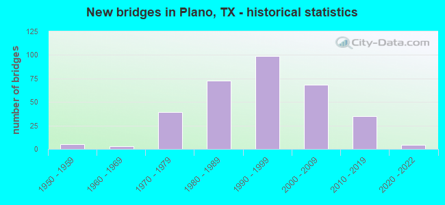
- New bridges - historical statistics
- 51950-1959
- 31960-1969
- 391970-1979
- 731980-1989
- 991990-1999
- 682000-2009
- 352010-2019
- 42020-2022

- Reconstructed bridges - Historical Statistics
- 61980-1989
- 171990-1999
- 42000-2009
- 112010-2019
- 102020-2022


- Bridge Condition - Deck
- 9.7%Very good
- 73.4%Good
- 15.6%Satisfactory
- 1.3%Fair

- Bridge Condition - Superstructure
- 36.4%Very good
- 51.9%Good
- 11.0%Satisfactory
- 0.6%Fair

- Bridge Condition - Substructure
- 0.6%Very good
- 64.9%Good
- 34.4%Satisfactory

- Bridge Condition - Channel
- 9.7%Very good
- 40.3%Good
- 44.2%Satisfactory
- 5.8%Fair

- Bridge Condition - Culverts
- 60.9%Good
- 37.3%Satisfactory
- 1.8%Fair
- 0.9%Poor
Find on map >> Show street view
Structure Number: 18043000090544, Location: 0.8 MI NE OF FM 1777 (Lat: 32.991461, Lng: -96.311917), Route carried "on" structure: State highway 66, Year Built: 2005, Status: Open, Structure Length: 3.66m (12.01ft), Average Daily Traffic: 3,229 (year 2020), Truck Traffic: 5%, Average Future Daily Traffic: 4,521 (year 2040), Design Load: HS 20, Features Intersected: SABINE CREEK
Minimum Vertical Clearance: 30+ m (98+ ft), Kilometerpoint: 3.090, Lanes on structure: 2, Owner: State Highway Agency, Approaching Roadway Width: 7.9m (25.9ft), Material/Design: Prestressed concrete, Design/Construction: Stringer/Multi-beam, Number Of Spans In Main Unit: 1, Length of Maximum Span: 36.6m (120.1ft), Curb-To-Curb Width: 13.2m (43.3ft), Out-to-Out Width: 14.0m (45.9ft)
Condition: Deck: Very good, Superstructure: Good, Substructure: Good, Channel: Satisfactory, Operating Rating: 54.4 metric tons, Method Used To Determine Operating Rating: Assigned rating based on Load Factor Design (LFD) reported in metric tons, Inventory Rating: 32.7 metric tons, Method Used To Determine Inventory Rating: Assigned rating based on Load Factor Design (LFD) reported in metric tons, Structural Evaluation: Better than present minimum criteria, Deck Geometry: Equal to present minimum criteria, Waterway Adequacy: Superior to present desirable criteria, Approach Roadway Alignment: Equal to present desirable criteria, Designated Inspection Frequency: Every 24 months, Inspection Date: September 2021, Deck Structure Type: Concrete Cast-file-Place
Find on map >> Show street view
Structure Number: 18043000470624, Location: 0.60 MI N OF 15TH ST (Lat: 33.028442, Lng: -96.709247), Route carried "on" structure: City street 27, Year Built: 1981, Status: Open, Structure Length: 11.89m (39.01ft), Average Daily Traffic: 19,170 (year 2019), Truck Traffic: 3%, Average Future Daily Traffic: 33,978 (year 2038), Design Load: HS 20, Features Intersected: US 75, Facility Carried by Structure: PARK BLVD
Minimum Vertical Clearance: 30+ m (98+ ft), Kilometerpoint: 13.518, Lanes on structure: 6, Lanes under structure: 18, Owner: State Highway Agency, Approaching Roadway Width: 21.3m (69.9ft), Skew: 11 degrees, Material/Design: Prestressed concrete, Design/Construction: Stringer/Multi-beam, Number Of Spans In Main Unit: 4, Number Of Approach Spans: 2, Length of Maximum Span: 24.4m (80.1ft), Curb or Sidewalk Widths: Left: 1.2m (3.9ft), Right: 1.2m (3.9ft), Curb-To-Curb Width: 21.3m (69.9ft), Out-to-Out Width: 29.4m (96.5ft)
Condition: Deck: Satisfactory, Superstructure: Satisfactory, Substructure: Good, Operating Rating: 54.4 metric tons, Method Used To Determine Operating Rating: Assigned rating based on Load Factor Design (LFD) reported in metric tons, Inventory Rating: 32.7 metric tons, Method Used To Determine Inventory Rating: Assigned rating based on Load Factor Design (LFD) reported in metric tons, Structural Evaluation: Equal to present minimum criteria, Deck Geometry: High priority of replacement, Underclear: High priority of corrective action, Approach Roadway Alignment: Equal to present desirable criteria, Designated Inspection Frequency: Every 24 months, Inspection Date: October 2021, Deck Structure Type: Concrete Cast-file-Place
Find on map >> Show street view
Structure Number: 180430004706276, Location: 1.10 MI N OF G BUSH TPKE (Lat: 33.019736, Lng: -96.709525), Route carried "on" structure: US 75, Year Built: 1989, Year Reconstructed: 2017, Status: Open, Structure Length: 8.44m (27.69ft), Average Daily Traffic: 198,758 (year 2020), Truck Traffic: 6%, Average Future Daily Traffic: 146,245 (year 2038), Design Load: HS 20, Features Intersected: E 15TH STREET
Minimum Vertical Clearance: 30+ m (98+ ft), Kilometerpoint: 19.647, Lanes on structure: 6, Lanes under structure: 7, Base Highway Network: Yes, Owner: State Highway Agency, Approaching Roadway Width: 24.7m (81.0ft), Skew: 1 degrees, Material/Design: Prestressed concrete, Design/Construction: Stringer/Multi-beam, Number Of Spans In Main Unit: 1, Number Of Approach Spans: 2, Length of Maximum Span: 33.8m (110.9ft), Curb-To-Curb Width: 24.8m (81.4ft), Out-to-Out Width: 25.6m (84.0ft)
Condition: Deck: Satisfactory, Superstructure: Very good, Substructure: Good, Operating Rating: 54.4 metric tons, Method Used To Determine Operating Rating: Assigned rating based on Load Factor Design (LFD) reported in metric tons, Inventory Rating: 32.7 metric tons, Method Used To Determine Inventory Rating: Assigned rating based on Load Factor Design (LFD) reported in metric tons, Structural Evaluation: Better than present minimum criteria, Deck Geometry: Meets minimum limits, Underclear: High priority of corrective action, Approach Roadway Alignment: Equal to present desirable criteria, Designated Inspection Frequency: Every 24 months, Inspection Date: October 2021, Deck Structure Type: Concrete Cast-file-Place
Find on map >> Show street view
Structure Number: 180430004706277, Location: US 75 & SPRING CRK PKWY (Lat: 33.057181, Lng: -96.694158), Route carried "on" structure: US 75, Year Built: 1989, Status: Open, Structure Length: 8.35m (27.40ft), Average Daily Traffic: 92,786 (year 2018), Truck Traffic: 6%, Average Future Daily Traffic: 129,901 (year 2038), Design Load: HS 20, Features Intersected: SPRING CREEK PKWY
Minimum Vertical Clearance: 30+ m (98+ ft), Kilometerpoint: 15.170, Lanes on structure: 5, Lanes under structure: 8, Base Highway Network: Yes, Owner: State Highway Agency, Approaching Roadway Width: 21.3m (69.9ft), Skew: 1 degrees, Material/Design: Prestressed concrete, Design/Construction: Stringer/Multi-beam, Number Of Spans In Main Unit: 1, Number Of Approach Spans: 2, Length of Maximum Span: 37.2m (122.0ft), Curb-To-Curb Width: 21.5m (70.5ft), Out-to-Out Width: 22.3m (73.2ft)
Condition: Deck: Good, Superstructure: Good, Substructure: Good, Operating Rating: 54.4 metric tons, Method Used To Determine Operating Rating: Assigned rating based on Load Factor Design (LFD) reported in metric tons, Inventory Rating: 32.7 metric tons, Method Used To Determine Inventory Rating: Assigned rating based on Load Factor Design (LFD) reported in metric tons, Structural Evaluation: Better than present minimum criteria, Deck Geometry: Meets minimum limits, Underclear: Meets minimum limits, Approach Roadway Alignment: Equal to present desirable criteria, Designated Inspection Frequency: Every 24 months, Inspection Date: October 2021, Deck Structure Type: Concrete Cast-file-Place
Find on map >> Show street view
Structure Number: 180430004706281, Location: 0.25 MI N OF 15TH ST (Lat: 33.023692, Lng: -96.710167), Route carried "on" structure: US 75, Year Built: 1989, Status: Open, Structure Length: 0.70m (2.30ft), Average Daily Traffic: 198,758 (year 2020), Truck Traffic: 6%, Average Future Daily Traffic: 345,797 (year 2038), Design Load: HS 20, Features Intersected: DRAIN
Minimum Vertical Clearance: 30+ m (98+ ft), Kilometerpoint: 19.264, Lanes on structure: 16, Base Highway Network: Yes, Owner: State Highway Agency, Approaching Roadway Width: 73.2m (240.2ft), Skew: 30 degrees, Material/Design: Concrete, Design/Construction: Culvert, Number Of Spans In Main Unit: 3, Length of Maximum Span: 2.1m (6.9ft)
Condition: Channel: Satisfactory, Culverts: Good, Operating Rating: 54.4 metric tons, Method Used To Determine Operating Rating: No rating analysis performed, Inventory Rating: 32.7 metric tons, Method Used To Determine Inventory Rating: No rating analysis performed, Structural Evaluation: Better than present minimum criteria, Waterway Adequacy: Superior to present desirable criteria, Approach Roadway Alignment: Equal to present desirable criteria, Designated Inspection Frequency: Every 24 months, Inspection Date: October 2021
Find on map >> Show street view
Structure Number: 180430004706282, Location: 0.45 MI N OF 15TH ST (Lat: 33.026567, Lng: -96.709736), Route carried "on" structure: US 75, Year Built: 1989, Status: Open, Structure Length: 1.01m (3.31ft), Average Daily Traffic: 198,758 (year 2020), Truck Traffic: 6%, Average Future Daily Traffic: 345,797 (year 2018), Design Load: HS 20, Features Intersected: DRAIN
Minimum Vertical Clearance: 30+ m (98+ ft), Kilometerpoint: 18.936, Lanes on structure: 18, Base Highway Network: Yes, Owner: State Highway Agency, Approaching Roadway Width: 68.3m (224.1ft), Skew: 34 degrees, Material/Design: Concrete, Design/Construction: Culvert, Number Of Spans In Main Unit: 3, Length of Maximum Span: 2.1m (6.9ft)
Condition: Channel: Satisfactory, Culverts: Good, Operating Rating: 54.4 metric tons, Method Used To Determine Operating Rating: No rating analysis performed, Inventory Rating: 32.7 metric tons, Method Used To Determine Inventory Rating: No rating analysis performed, Structural Evaluation: Better than present minimum criteria, Waterway Adequacy: Superior to present desirable criteria, Approach Roadway Alignment: Equal to present desirable criteria, Designated Inspection Frequency: Every 24 months, Inspection Date: October 2021
Find on map >> Show street view
Structure Number: 180430004706283, Location: 0.30 MI N OF PARKER RD (Lat: 33.040644, Lng: -96.702894), Route carried "on" structure: US 75, Year Built: 1989, Year Reconstructed: 2001, Status: Open, Structure Length: 1.13m (3.71ft), Average Daily Traffic: 176,664 (year 2020), Truck Traffic: 6%, Average Future Daily Traffic: 259,801 (year 2038), Design Load: HS 20, Features Intersected: DRAIN
Minimum Vertical Clearance: 30+ m (98+ ft), Kilometerpoint: 17.157, Lanes on structure: 17, Base Highway Network: Yes, Owner: State Highway Agency, Approaching Roadway Width: 67.7m (222.1ft), Skew: 34 degrees, Material/Design: Concrete, Design/Construction: Culvert, Number Of Spans In Main Unit: 3, Length of Maximum Span: 2.4m (7.9ft)
Condition: Channel: Satisfactory, Culverts: Satisfactory, Operating Rating: 54.4 metric tons, Method Used To Determine Operating Rating: No rating analysis performed, Inventory Rating: 32.7 metric tons, Method Used To Determine Inventory Rating: No rating analysis performed, Structural Evaluation: Equal to present minimum criteria, Waterway Adequacy: Superior to present desirable criteria, Approach Roadway Alignment: Equal to present desirable criteria, Designated Inspection Frequency: Every 24 months, Inspection Date: October 2021
Find on map >> Show street view
Structure Number: 180430004706284, Location: 0.80 MI S OF SPRING CREEK (Lat: 33.046517, Lng: -96.699769), Route carried "on" structure: US 75, Year Built: 1989, Status: Open, Structure Length: 1.31m (4.30ft), Average Daily Traffic: 176,664 (year 2020), Truck Traffic: 6%, Average Future Daily Traffic: 337,633 (year 2038), Design Load: HS 20, Features Intersected: BOWMAN BRANCH
Minimum Vertical Clearance: 30+ m (98+ ft), Kilometerpoint: 16.485, Lanes on structure: 17, Base Highway Network: Yes, Owner: State Highway Agency, Approaching Roadway Width: 67.7m (222.1ft), Skew: 30 degrees, Material/Design: Concrete, Design/Construction: Culvert, Number Of Spans In Main Unit: 5, Length of Maximum Span: 2.4m (7.9ft)
Condition: Channel: Satisfactory, Culverts: Satisfactory, Operating Rating: 54.4 metric tons, Method Used To Determine Operating Rating: No rating analysis performed, Inventory Rating: 32.7 metric tons, Method Used To Determine Inventory Rating: No rating analysis performed, Structural Evaluation: Equal to present minimum criteria, Waterway Adequacy: Superior to present desirable criteria, Approach Roadway Alignment: Equal to present desirable criteria, Designated Inspection Frequency: Every 24 months, Inspection Date: October 2021
Find on map >> Show street view
Structure Number: 180430004706285, Location: 0.7 MI S OF SPRING CREEK (Lat: 33.047631, Lng: -96.699194), Route carried "on" structure: US 75, Year Built: 1989, Year Reconstructed: 1999, Status: Open, Structure Length: 0.91m (2.99ft), Average Daily Traffic: 176,664 (year 2020), Truck Traffic: 6%, Average Future Daily Traffic: 337,633 (year 2038), Design Load: HS 20, Features Intersected: DRAIN
Minimum Vertical Clearance: 30+ m (98+ ft), Kilometerpoint: 16.343, Lanes on structure: 17, Base Highway Network: Yes, Owner: State Highway Agency, Approaching Roadway Width: 75.3m (247.0ft), Skew: 30 degrees, Material/Design: Concrete, Design/Construction: Culvert, Number Of Spans In Main Unit: 4, Length of Maximum Span: 2.1m (6.9ft)
Condition: Channel: Satisfactory, Culverts: Good, Operating Rating: 54.4 metric tons, Method Used To Determine Operating Rating: No rating analysis performed, Inventory Rating: 32.7 metric tons, Method Used To Determine Inventory Rating: No rating analysis performed, Structural Evaluation: Better than present minimum criteria, Waterway Adequacy: Superior to present desirable criteria, Approach Roadway Alignment: Equal to present desirable criteria, Designated Inspection Frequency: Every 24 months, Inspection Date: October 2021
Find on map >> Show street view
Structure Number: 180430004706286, Location: 0.15 MI S OF SPRING CREEK (Lat: 33.055281, Lng: -96.695156), Route carried "on" structure: US 75, Year Built: 1989, Status: Open, Structure Length: 1.34m (4.40ft), Average Daily Traffic: 176,664 (year 2020), Truck Traffic: 6%, Average Future Daily Traffic: 337,633 (year 2018), Design Load: HS 20, Features Intersected: BROWN BRANCH
Minimum Vertical Clearance: 30+ m (98+ ft), Kilometerpoint: 15.434, Lanes on structure: 16, Base Highway Network: Yes, Owner: State Highway Agency, Approaching Roadway Width: 73.2m (240.2ft), Skew: 30 degrees, Material/Design: Concrete, Design/Construction: Culvert, Number Of Spans In Main Unit: 5, Length of Maximum Span: 2.4m (7.9ft)
Condition: Channel: Satisfactory, Culverts: Good, Operating Rating: 54.4 metric tons, Method Used To Determine Operating Rating: No rating analysis performed, Inventory Rating: 32.7 metric tons, Method Used To Determine Inventory Rating: No rating analysis performed, Structural Evaluation: Better than present minimum criteria, Waterway Adequacy: Superior to present desirable criteria, Approach Roadway Alignment: Equal to present desirable criteria, Designated Inspection Frequency: Every 24 months, Inspection Date: October 2021
Find on map >> Show street view
Structure Number: 180430004706297, Location: 2.55 MI S OF FM 2170 (Lat: 33.066097, Lng: -96.690289), Route carried "on" structure: City street , Year Built: 1992, Status: Open, Structure Length: 9.60m (31.50ft), Average Daily Traffic: 17,047 (year 2019), Truck Traffic: 3%, Average Future Daily Traffic: 52,101 (year 2038), Design Load: HS 20, Features Intersected: US 75, Facility Carried by Structure: LEGACY DRIVE
Minimum Vertical Clearance: 30+ m (98+ ft), Kilometerpoint: 0.805, Lanes on structure: 7, Lanes under structure: 14, Owner: State Highway Agency, Approaching Roadway Width: 21.3m (69.9ft), Skew: 20 degrees, Material/Design: Prestressed concrete, Design/Construction: Stringer/Multi-beam, Number Of Spans In Main Unit: 2, Number Of Approach Spans: 3, Length of Maximum Span: 25.9m (85.0ft), Curb or Sidewalk Widths: Left: 1.8m (5.9ft), Right: 1.8m (5.9ft), Curb-To-Curb Width: 24.4m (80.1ft), Out-to-Out Width: 30.2m (99.1ft)
Condition: Deck: Satisfactory, Superstructure: Good, Substructure: Satisfactory, Operating Rating: 54.4 metric tons, Method Used To Determine Operating Rating: Assigned rating based on Load Factor Design (LFD) reported in metric tons, Inventory Rating: 32.7 metric tons, Method Used To Determine Inventory Rating: Assigned rating based on Load Factor Design (LFD) reported in metric tons, Structural Evaluation: Equal to present minimum criteria, Deck Geometry: High priority of replacement, Underclear: High priority of corrective action, Approach Roadway Alignment: Equal to present desirable criteria, Length Of Structure Improvement: 9.60m (31.50ft), Designated Inspection Frequency: Every 24 months, Inspection Date: October 2021, Bridge Improvement Cost: $50,000, Roadway Improvement Cost: $13,000, Total Project Cost: $63,000, Deck Structure Type: Concrete Cast-file-Place
Find on map >> Show street view
Structure Number: 180430004706299, Location: 1.90 MI S OF FM 2170 (Lat: 33.075406, Lng: -96.686458), Route carried "on" structure: US 75, Year Built: 1992, Year Reconstructed: 2015, Status: Open, Structure Length: 8.53m (27.99ft), Average Daily Traffic: 82,600 (year 2015), Truck Traffic: 6%, Average Future Daily Traffic: 125,500 (year 2035), Design Load: HS 20, Features Intersected: ROWLETT CREEK
Minimum Vertical Clearance: 30+ m (98+ ft), Kilometerpoint: 13.000, Lanes on structure: 5, Owner: State Highway Agency, Approaching Roadway Width: 21.6m (70.9ft), Material/Design: Concrete, Design/Construction: Stringer/Multi-beam, Number Of Spans In Main Unit: 7, Length of Maximum Span: 12.2m (40.0ft), Curb-To-Curb Width: 21.6m (70.9ft), Out-to-Out Width: 22.3m (73.2ft)
Condition: Deck: Satisfactory, Superstructure: Satisfactory, Substructure: Satisfactory, Channel: Satisfactory, Operating Rating: 54.4 metric tons, Method Used To Determine Operating Rating: Assigned rating based on Load Factor Design (LFD) reported in metric tons, Inventory Rating: 32.7 metric tons, Method Used To Determine Inventory Rating: Assigned rating based on Load Factor Design (LFD) reported in metric tons, Structural Evaluation: Equal to present minimum criteria, Deck Geometry: Meets minimum limits, Waterway Adequacy: Superior to present desirable criteria, Approach Roadway Alignment: Equal to present desirable criteria, Length Of Structure Improvement: 8.53m (27.99ft), Designated Inspection Frequency: Every 24 months, Inspection Date: October 2021, Deck Structure Type: Concrete Cast-file-Place, Wearing Surface/Protective System: Deck Protection: Epoxy Coated Reinforcing
Find on map >> Show street view
Structure Number: 1804300047063, Location: 1.90 MI S OF FM 2170 (Lat: 33.075422, Lng: -96.686583), Route carried "on" structure: US 75, Year Built: 1992, Year Reconstructed: 2015, Status: Open, Structure Length: 8.53m (27.99ft), Average Daily Traffic: 80,567 (year 2018), Truck Traffic: 6%, Average Future Daily Traffic: 112,793 (year 2038), Design Load: HS 20, Features Intersected: ROWLETT CREEK
Minimum Vertical Clearance: 30+ m (98+ ft), Kilometerpoint: 13.000, Lanes on structure: 5, Base Highway Network: Yes, Owner: State Highway Agency, Approaching Roadway Width: 21.6m (70.9ft), Skew: 30 degrees, Material/Design: Concrete, Design/Construction: Stringer/Multi-beam, Number Of Spans In Main Unit: 7, Length of Maximum Span: 12.2m (40.0ft), Curb-To-Curb Width: 21.6m (70.9ft), Out-to-Out Width: 22.3m (73.2ft)
Condition: Deck: Fair, Superstructure: Good, Substructure: Satisfactory, Channel: Satisfactory, Operating Rating: 54.4 metric tons, Method Used To Determine Operating Rating: Assigned rating based on Load Factor Design (LFD) reported in metric tons, Inventory Rating: 32.7 metric tons, Method Used To Determine Inventory Rating: Assigned rating based on Load Factor Design (LFD) reported in metric tons, Structural Evaluation: Equal to present minimum criteria, Deck Geometry: Meets minimum limits, Waterway Adequacy: Superior to present desirable criteria, Approach Roadway Alignment: Equal to present desirable criteria, Designated Inspection Frequency: Every 24 months, Inspection Date: October 2021, Deck Structure Type: Concrete Cast-file-Place, Wearing Surface/Protective System: Deck Protection: Epoxy Coated Reinforcing
Find on map >> Show street view
Structure Number: 180430004706301, Location: 1.90 MI S OF FM 2170 (Lat: 33.075325, Lng: -96.686800), Route carried "on" structure: ServiceUS 75, Year Built: 1992, Status: Open, Structure Length: 8.53m (27.99ft), Average Daily Traffic: 16,740 (year 2013), Truck Traffic: 7%, Average Future Daily Traffic: 23,440 (year 2033), Design Load: HS 20, Features Intersected: ROWLETT CREEK
Minimum Vertical Clearance: 30+ m (98+ ft), Kilometerpoint: 13.028, Lanes on structure: 2, Owner: State Highway Agency, Approaching Roadway Width: 10.1m (33.1ft), Material/Design: Concrete, Design/Construction: Stringer/Multi-beam, Number Of Spans In Main Unit: 7, Length of Maximum Span: 12.2m (40.0ft), Curb-To-Curb Width: 10.8m (35.4ft), Out-to-Out Width: 11.6m (38.1ft)
Condition: Deck: Good, Superstructure: Good, Substructure: Satisfactory, Channel: Fair, Operating Rating: 54.4 metric tons, Method Used To Determine Operating Rating: Assigned rating based on Load Factor Design (LFD) reported in metric tons, Inventory Rating: 32.7 metric tons, Method Used To Determine Inventory Rating: Assigned rating based on Load Factor Design (LFD) reported in metric tons, Structural Evaluation: Equal to present minimum criteria, Deck Geometry: Somewhat better than minimum adequacy, Waterway Adequacy: Superior to present desirable criteria, Approach Roadway Alignment: Equal to present desirable criteria, Designated Inspection Frequency: Every 24 months, Inspection Date: October 2021, Deck Structure Type: Concrete Cast-file-Place, Wearing Surface/Protective System: Deck Protection: Epoxy Coated Reinforcing
Find on map >> Show street view
Structure Number: 180430004706346, Location: 0.20 MI S OF PLANO PKWY (Lat: 33.006747, Lng: -96.707914), Route carried "on" structure: US 75, Year Built: 1992, Year Reconstructed: 1996, Status: Open, Structure Length: 1.62m (5.31ft), Average Daily Traffic: 217,943 (year 2020), Truck Traffic: 5%, Average Future Daily Traffic: 429,430 (year 2038), Design Load: HS 20, Features Intersected: DRAIN
Minimum Vertical Clearance: 30+ m (98+ ft), Kilometerpoint: 21.127, Lanes on structure: 17, Base Highway Network: Yes, Owner: State Highway Agency, Approaching Roadway Width: 84.1m (275.9ft), Skew: 9 degrees, Material/Design: Concrete, Design/Construction: Culvert, Number Of Spans In Main Unit: 6, Length of Maximum Span: 1.8m (5.9ft)
Condition: Channel: Satisfactory, Culverts: Good, Operating Rating: 54.4 metric tons, Method Used To Determine Operating Rating: No rating analysis performed, Inventory Rating: 32.7 metric tons, Method Used To Determine Inventory Rating: No rating analysis performed, Structural Evaluation: Better than present minimum criteria, Waterway Adequacy: Superior to present desirable criteria, Approach Roadway Alignment: Equal to present desirable criteria, Designated Inspection Frequency: Every 24 months, Inspection Date: October 2021
Find on map >> Show street view
Structure Number: 180430004706427, Location: 1.10 MI N OF G BUSH TNPKE (Lat: 33.019375, Lng: -96.709569), Route carried "on" structure: US 75, Year Built: 1989, Status: Open, Structure Length: 8.44m (27.69ft), Average Daily Traffic: 109,019 (year 2019), Truck Traffic: 6%, Average Future Daily Traffic: 146,245 (year 2038), Design Load: HS 20, Features Intersected: E 15TH STREET
Minimum Vertical Clearance: 30+ m (98+ ft), Kilometerpoint: 19.647, Lanes on structure: 5, Lanes under structure: 7, Base Highway Network: Yes, Owner: State Highway Agency, Approaching Roadway Width: 21.3m (69.9ft), Skew: 1 degrees, Material/Design: Prestressed concrete, Design/Construction: Stringer/Multi-beam, Number Of Spans In Main Unit: 1, Number Of Approach Spans: 2, Length of Maximum Span: 33.8m (110.9ft), Curb-To-Curb Width: 21.6m (70.9ft), Out-to-Out Width: 22.3m (73.2ft)
Condition: Deck: Good, Superstructure: Good, Substructure: Good, Operating Rating: 54.4 metric tons, Method Used To Determine Operating Rating: Assigned rating based on Load Factor Design (LFD) reported in metric tons, Inventory Rating: 32.7 metric tons, Method Used To Determine Inventory Rating: Assigned rating based on Load Factor Design (LFD) reported in metric tons, Structural Evaluation: Better than present minimum criteria, Deck Geometry: Somewhat better than minimum adequacy, Underclear: High priority of corrective action, Approach Roadway Alignment: Equal to present desirable criteria, Designated Inspection Frequency: Every 24 months, Inspection Date: October 2021, Deck Structure Type: Concrete Cast-file-Place
Find on map >> Show street view
Structure Number: 180430004706428, Location: AT US 75-SPRING CRK PKWAY (Lat: 33.057161, Lng: -96.694339), Route carried "on" structure: US 75, Year Built: 1989, Status: Open, Structure Length: 8.35m (27.40ft), Average Daily Traffic: 92,786 (year 2018), Truck Traffic: 6%, Average Future Daily Traffic: 129,901 (year 2038), Design Load: HS 20, Features Intersected: SPRING CREEK PKWY
Minimum Vertical Clearance: 30+ m (98+ ft), Kilometerpoint: 15.178, Lanes on structure: 5, Lanes under structure: 8, Base Highway Network: Yes, Owner: State Highway Agency, Approaching Roadway Width: 21.3m (69.9ft), Skew: 1 degrees, Material/Design: Prestressed concrete, Design/Construction: Stringer/Multi-beam, Number Of Spans In Main Unit: 1, Number Of Approach Spans: 2, Length of Maximum Span: 37.2m (122.0ft), Curb-To-Curb Width: 21.5m (70.5ft), Out-to-Out Width: 22.3m (73.2ft)
Condition: Deck: Good, Superstructure: Very good, Substructure: Good, Operating Rating: 54.4 metric tons, Method Used To Determine Operating Rating: Assigned rating based on Load Factor Design (LFD) reported in metric tons, Inventory Rating: 32.7 metric tons, Method Used To Determine Inventory Rating: Assigned rating based on Load Factor Design (LFD) reported in metric tons, Structural Evaluation: Better than present minimum criteria, Deck Geometry: Meets minimum limits, Underclear: High priority of corrective action, Approach Roadway Alignment: Equal to present desirable criteria, Designated Inspection Frequency: Every 24 months, Inspection Date: October 2021, Deck Structure Type: Concrete Cast-file-Place
Find on map >> Show street view
Structure Number: 180430004706609, Location: 1.25 MI N OF 15TH ST (Lat: 33.037711, Lng: -96.705019), Route carried "on" structure: City street 25, Year Built: 2010, Status: Open, Structure Length: 9.08m (29.79ft), Average Daily Traffic: 27,484 (year 2019), Truck Traffic: 3%, Average Future Daily Traffic: 38,219 (year 2038), Design Load: HS 20, Features Intersected: US 75, Facility Carried by Structure: PARKER RD-CENTER
Minimum Vertical Clearance: 30+ m (98+ ft), Kilometerpoint: 10.511, Lanes on structure: 8, Lanes under structure: 14, Owner: State Highway Agency, Approaching Roadway Width: 24.4m (80.1ft), Skew: 21 degrees, Material/Design: Prestressed concrete, Design/Construction: Stringer/Multi-beam, Number Of Spans In Main Unit: 4, Length of Maximum Span: 25.0m (82.0ft), Curb-To-Curb Width: 24.4m (80.1ft), Out-to-Out Width: 32.6m (107.0ft)
Condition: Deck: Good, Superstructure: Very good, Substructure: Good, Operating Rating: 54.4 metric tons, Method Used To Determine Operating Rating: Assigned rating based on Load Factor Design (LFD) reported in metric tons, Inventory Rating: 32.7 metric tons, Method Used To Determine Inventory Rating: Assigned rating based on Load Factor Design (LFD) reported in metric tons, Structural Evaluation: Better than present minimum criteria, Deck Geometry: High priority of replacement, Underclear: High priority of corrective action, Approach Roadway Alignment: Equal to present desirable criteria, Designated Inspection Frequency: Every 24 months, Inspection Date: October 2021, Deck Structure Type: Concrete Cast-file-Place
Find on map >> Show street view
Structure Number: 18043000470661, Location: 1.25 MI N OF 15TH ST. (Lat: 33.037725, Lng: -96.704367), Route carried "on" structure: ServiceCity street 25, Year Built: 2010, Status: Open, Structure Length: 4.94m (16.21ft), Average Daily Traffic: 9,100 (year 2018), Truck Traffic: 3%, Average Future Daily Traffic: 12,740 (year 2038), Design Load: HS 20, Features Intersected: US 75, Facility Carried by Structure: PARKER RD (NORTH)
Minimum Vertical Clearance: 30+ m (98+ ft), Kilometerpoint: 10.511, Lanes on structure: 1, Lanes under structure: 10, Owner: State Highway Agency, Approaching Roadway Width: 8.2m (26.9ft), Skew: 1 degrees, Material/Design: Prestressed concrete, Design/Construction: Stringer/Multi-beam, Number Of Spans In Main Unit: 2, Length of Maximum Span: 24.7m (81.0ft), Curb or Sidewalk Widths: Left: 0.0m, Right: 3.0m (9.8ft), Curb-To-Curb Width: 10.3m (33.8ft), Out-to-Out Width: 25.4m (83.3ft)
Condition: Deck: Good, Superstructure: Very good, Substructure: Good, Operating Rating: 54.4 metric tons, Method Used To Determine Operating Rating: Assigned rating based on Load Factor Design (LFD) reported in metric tons, Inventory Rating: 32.7 metric tons, Method Used To Determine Inventory Rating: Assigned rating based on Load Factor Design (LFD) reported in metric tons, Structural Evaluation: Better than present minimum criteria, Deck Geometry: Meets minimum limits, Underclear: High priority of corrective action, Approach Roadway Alignment: Meets minimum limits, Designated Inspection Frequency: Every 24 months, Inspection Date: October 2021, Deck Structure Type: Concrete Cast-file-Place
Find on map >> Show street view
Structure Number: 180430004706611, Location: 1.25 MI N OF 15TH ST (Lat: 33.037239, Lng: -96.704889), Route carried "on" structure: ServiceCity street 25, Year Built: 2010, Status: Open, Structure Length: 4.94m (16.21ft), Average Daily Traffic: 9,100 (year 2018), Truck Traffic: 3%, Average Future Daily Traffic: 12,740 (year 2038), Design Load: HS 20, Features Intersected: US 75, Facility Carried by Structure: PARKER RD (SOUTH)
Minimum Vertical Clearance: 30+ m (98+ ft), Kilometerpoint: 10.511, Lanes on structure: 1, Lanes under structure: 10, Owner: State Highway Agency, Approaching Roadway Width: 9.1m (29.9ft), Skew: 1 degrees, Material/Design: Prestressed concrete, Design/Construction: Stringer/Multi-beam, Number Of Spans In Main Unit: 2, Length of Maximum Span: 24.7m (81.0ft), Curb or Sidewalk Widths: Left: 0.0m, Right: 3.0m (9.8ft), Curb-To-Curb Width: 10.6m (34.8ft), Out-to-Out Width: 23.7m (77.8ft)
Condition: Deck: Good, Superstructure: Very good, Substructure: Good, Operating Rating: 54.4 metric tons, Method Used To Determine Operating Rating: Assigned rating based on Load Factor Design (LFD) reported in metric tons, Inventory Rating: 32.7 metric tons, Method Used To Determine Inventory Rating: Assigned rating based on Load Factor Design (LFD) reported in metric tons, Structural Evaluation: Better than present minimum criteria, Deck Geometry: Meets minimum limits, Underclear: High priority of corrective action, Approach Roadway Alignment: Meets minimum limits, Designated Inspection Frequency: Every 24 months, Inspection Date: October 2021, Deck Structure Type: Concrete Cast-file-Place
Find on map >> Show street view
Structure Number: 180430004706662, Location: 0.3 mi N of PGBT (Lat: 33.009089, Lng: -96.707939), Route carried "on" structure: City street , Year Built: 2019, Status: Open, Structure Length: 8.14m (26.71ft), Average Daily Traffic: 32,450 (year 2014), Truck Traffic: 5%, Average Future Daily Traffic: 44,845 (year 2032), Design Load: HL 93, Features Intersected: US 75, Facility Carried by Structure: Plano Pkwy. EB
Minimum Vertical Clearance: 30+ m (98+ ft), Kilometerpoint: 20.872, Lanes on structure: 5, Lanes under structure: 15, Owner: State Highway Agency, Approaching Roadway Width: 10.1m (33.1ft), Material/Design: Prestressed concrete, Design/Construction: Stringer/Multi-beam, Number Of Spans In Main Unit: 2, Number Of Approach Spans: 2, Length of Maximum Span: 27.0m (88.6ft), Curb or Sidewalk Widths: Left: 0.0m, Right: 1.8m (5.9ft), Curb-To-Curb Width: 14.6m (47.9ft), Out-to-Out Width: 25.6m (84.0ft)
Condition: Deck: Very good, Superstructure: Very good, Substructure: Very good, Operating Rating: 54.4 metric tons, Method Used To Determine Operating Rating: Assigned ratings based on Load and Resistance Factor Design (LRFD) reported in metric tons, Inventory Rating: 32.7 metric tons, Method Used To Determine Inventory Rating: Assigned ratings based on Load and Resistance Factor Design (LRFD) reported in metric tons, Structural Evaluation: Equal to present desirable criteria, Deck Geometry: High priority of replacement, Underclear: High priority of corrective action, Approach Roadway Alignment: Equal to present desirable criteria, Designated Inspection Frequency: Every 24 months, Inspection Date: March 2021, Deck Structure Type: Concrete Precast Panels
Find on map >> Show street view
Structure Number: 180430004706663, Location: 0.3 mi N of PGBT (Lat: 33.009089, Lng: -96.707939), Route carried "on" structure: City street , Year Built: 2019, Status: Open, Structure Length: 8.14m (26.71ft), Average Daily Traffic: 32,450 (year 2014), Truck Traffic: 5%, Average Future Daily Traffic: 44,845 (year 2032), Design Load: HL 93, Features Intersected: US 75, Facility Carried by Structure: Plano Pkwy. WB
Minimum Vertical Clearance: 30+ m (98+ ft), Kilometerpoint: 20.872, Lanes on structure: 5, Lanes under structure: 15, Owner: State Highway Agency, Approaching Roadway Width: 11.0m (36.1ft), Material/Design: Prestressed concrete, Design/Construction: Stringer/Multi-beam, Number Of Spans In Main Unit: 2, Number Of Approach Spans: 2, Length of Maximum Span: 27.0m (88.6ft), Curb or Sidewalk Widths: Left: 0.0m, Right: 1.8m (5.9ft), Curb-To-Curb Width: 14.6m (47.9ft), Out-to-Out Width: 25.6m (84.0ft)
Condition: Deck: Very good, Superstructure: Very good, Substructure: Good, Operating Rating: 54.4 metric tons, Method Used To Determine Operating Rating: Assigned ratings based on Load and Resistance Factor Design (LRFD) reported in metric tons, Inventory Rating: 32.7 metric tons, Method Used To Determine Inventory Rating: Assigned ratings based on Load and Resistance Factor Design (LRFD) reported in metric tons, Structural Evaluation: Better than present minimum criteria, Deck Geometry: High priority of replacement, Underclear: High priority of corrective action, Approach Roadway Alignment: Equal to present desirable criteria, Designated Inspection Frequency: Every 24 months, Inspection Date: March 2021, Deck Structure Type: Concrete Precast Panels
Find on map >> Show street view
Structure Number: 180430009105038, Location: 0.05 MI N OF SPRING CRK (Lat: 33.057344, Lng: -96.795472), Route carried "on" structure: State highway 289, Year Built: 1955, Year Reconstructed: 1989, Status: Open, Structure Length: 1.40m (4.59ft), Average Daily Traffic: 33,476 (year 2020), Truck Traffic: 1%, Average Future Daily Traffic: 46,866 (year 2040), Features Intersected: WELLS CRK
Minimum Vertical Clearance: 30+ m (98+ ft), Kilometerpoint: 42.292, Lanes on structure: 9, Owner: State Highway Agency, Approaching Roadway Width: 23.2m (76.1ft), Skew: 20 degrees, Material/Design: Concrete, Design/Construction: Culvert, Number Of Spans In Main Unit: 4, Length of Maximum Span: 3.0m (9.8ft), Curb or Sidewalk Widths: Left: 1.5m (4.9ft), Right: 1.5m (4.9ft), Curb-To-Curb Width: 29.4m (96.5ft), Out-to-Out Width: 44.5m (146.0ft)
Condition: Channel: Good, Culverts: Satisfactory, Operating Rating: 32.7 metric tons, Method Used To Determine Operating Rating: No rating analysis performed, Inventory Rating: 24.5 metric tons, Method Used To Determine Inventory Rating: No rating analysis performed, Structural Evaluation: Equal to present minimum criteria, Deck Geometry: High priority of replacement, Waterway Adequacy: Superior to present desirable criteria, Approach Roadway Alignment: Equal to present desirable criteria, Designated Inspection Frequency: Every 24 months, Inspection Date: November 2021, Deck Structure Type: Concrete Cast-file-Place, Wearing Surface/Protective System: Wearing Surface: Monolithic Concrete
Find on map >> Show street view
Structure Number: 180430009105039, Location: 0.50 MI S OF SPRING CRK (Lat: 33.049136, Lng: -96.794397), Route carried "on" structure: State highway 289, Year Built: 1955, Year Reconstructed: 1995, Status: Open, Structure Length: 1.71m (5.61ft), Average Daily Traffic: 33,476 (year 2020), Truck Traffic: 1%, Average Future Daily Traffic: 46,866 (year 2040), Features Intersected: HARRINGTON CREEK
Minimum Vertical Clearance: 30+ m (98+ ft), Kilometerpoint: 43.214, Lanes on structure: 6, Owner: State Highway Agency, Approaching Roadway Width: 34.1m (111.9ft), Skew: 30 degrees, Material/Design: Concrete, Design/Construction: Culvert, Number Of Spans In Main Unit: 6, Length of Maximum Span: 2.4m (7.9ft), Curb or Sidewalk Widths: Left: 1.2m (3.9ft), Right: 1.2m (3.9ft), Curb-To-Curb Width: 21.9m (71.9ft), Out-to-Out Width: 34.1m (111.9ft)
Condition: Channel: Good, Culverts: Satisfactory, Operating Rating: 32.7 metric tons, Method Used To Determine Operating Rating: No rating analysis performed, Inventory Rating: 24.5 metric tons, Method Used To Determine Inventory Rating: No rating analysis performed, Structural Evaluation: Equal to present minimum criteria, Deck Geometry: High priority of corrective action, Waterway Adequacy: Superior to present desirable criteria, Approach Roadway Alignment: Equal to present desirable criteria, Designated Inspection Frequency: Every 24 months, Inspection Date: November 2021, Deck Structure Type: Concrete Cast-file-Place, Wearing Surface/Protective System: Wearing Surface: Monolithic Concrete
Find on map >> Show street view
Structure Number: 18043000910504, Location: 0.60 MI S OF PARKER ROAD (Lat: 33.033353, Lng: -96.794708), Route carried "on" structure: State highway 289, Year Built: 1955, Year Reconstructed: 1989, Status: Open, Structure Length: 1.25m (4.10ft), Average Daily Traffic: 33,476 (year 2020), Truck Traffic: 1%, Average Future Daily Traffic: 46,866 (year 2040), Features Intersected: JOHNSTON CREEK
Minimum Vertical Clearance: 30+ m (98+ ft), Kilometerpoint: 44.975, Lanes on structure: 6, Owner: State Highway Agency, Approaching Roadway Width: 23.2m (76.1ft), Skew: 20 degrees, Material/Design: Concrete, Design/Construction: Culvert, Number Of Spans In Main Unit: 5, Length of Maximum Span: 2.1m (6.9ft), Curb or Sidewalk Widths: Left: 1.5m (4.9ft), Right: 1.2m (3.9ft), Curb-To-Curb Width: 23.2m (76.1ft), Out-to-Out Width: 34.1m (111.9ft)
Condition: Channel: Satisfactory, Culverts: Good, Operating Rating: 32.7 metric tons, Method Used To Determine Operating Rating: No rating analysis performed, Inventory Rating: 24.5 metric tons, Method Used To Determine Inventory Rating: No rating analysis performed, Structural Evaluation: Equal to present minimum criteria, Deck Geometry: Meets minimum limits, Waterway Adequacy: Superior to present desirable criteria, Approach Roadway Alignment: Equal to present desirable criteria, Designated Inspection Frequency: Every 24 months, Inspection Date: November 2021, Deck Structure Type: Concrete Cast-file-Place, Wearing Surface/Protective System: Wearing Surface: Monolithic Concrete
Find on map >> Show street view
Structure Number: 180430009105053, Location: 0.05 MI N OF G BUSH TPKE (Lat: 33.013242, Lng: -96.795564), Route carried "on" structure: State highway 289, Year Built: 1989, Year Reconstructed: 2021, Status: Open, Structure Length: 3.66m (12.01ft), Average Daily Traffic: 34,132 (year 2020), Truck Traffic: 1%, Average Future Daily Traffic: 47,785 (year 2040), Design Load: HS 20, Features Intersected: KCS RAILROAD
Minimum Vertical Clearance: 30+ m (98+ ft), Kilometerpoint: 47.265, Lanes on structure: 9, Owner: State Highway Agency, Approaching Roadway Width: 21.9m (71.9ft), Skew: 20 degrees, Material/Design: Prestressed concrete, Design/Construction: Box Beam or Girders - Multiple, Number Of Spans In Main Unit: 3, Length of Maximum Span: 13.7m (44.9ft), Curb or Sidewalk Widths: Left: 1.9m (6.2ft), Right: 2.3m (7.5ft), Curb-To-Curb Width: 33.3m (109.3ft), Out-to-Out Width: 40.7m (133.5ft)
Condition: Deck: Good, Superstructure: Satisfactory, Substructure: Satisfactory, Operating Rating: 54.4 metric tons, Method Used To Determine Operating Rating: Assigned rating based on Load Factor Design (LFD) reported in metric tons, Inventory Rating: 32.7 metric tons, Method Used To Determine Inventory Rating: Assigned rating based on Load Factor Design (LFD) reported in metric tons, Structural Evaluation: Equal to present minimum criteria, Deck Geometry: Meets minimum limits, Underclear: Meets minimum limits, Approach Roadway Alignment: Equal to present desirable criteria, Length Of Structure Improvement: 3.66m (12.01ft), Designated Inspection Frequency: Every 24 months, Inspection Date: November 2021, Bridge Improvement Cost: $20,000, Roadway Improvement Cost: $5,000, Total Project Cost: $25,000, Deck Structure Type: Concrete Cast-file-Place
Find on map >> Show street view
Structure Number: 180430009105054, Location: 0.20 MI S OF LEGACY DR (Lat: 33.068383, Lng: -96.796117), Route carried "on" structure: State highway 289, Year Built: 1989, Status: Open, Structure Length: 1.46m (4.79ft), Average Daily Traffic: 33,476 (year 2020), Truck Traffic: 1%, Average Future Daily Traffic: 63,095 (year 2038), Design Load: HS 20, Features Intersected: DRAW
Minimum Vertical Clearance: 30+ m (98+ ft), Kilometerpoint: 41.033, Lanes on structure: 6, Base Highway Network: Yes, Owner: State Highway Agency, Approaching Roadway Width: 23.2m (76.1ft), Skew: 20 degrees, Material/Design: Concrete, Design/Construction: Culvert, Number Of Spans In Main Unit: 4, Length of Maximum Span: 3.0m (9.8ft), Curb or Sidewalk Widths: Left: 1.2m (3.9ft), Right: 0.0m, Curb-To-Curb Width: 23.2m (76.1ft), Out-to-Out Width: 60.7m (199.1ft)
Condition: Channel: Satisfactory, Culverts: Good, Operating Rating: 39.9 metric tons, Method Used To Determine Operating Rating: Load Factor (LF), Inventory Rating: 23.6 metric tons, Method Used To Determine Inventory Rating: Load Factor (LF), Structural Evaluation: Somewhat better than minimum adequacy, Deck Geometry: Meets minimum limits, Waterway Adequacy: Superior to present desirable criteria, Approach Roadway Alignment: Equal to present desirable criteria, Designated Inspection Frequency: Every 48 months, Inspection Date: December 2019, Deck Structure Type: Concrete Cast-file-Place, Wearing Surface/Protective System: Wearing Surface: Monolithic Concrete
Find on map >> Show street view
Structure Number: 180430009105055, Location: 0.35 MI S OF SPRING CRK (Lat: 33.051119, Lng: -96.794378), Route carried "on" structure: State highway 289, Year Built: 1955, Year Reconstructed: 1989, Status: Open, Structure Length: 1.68m (5.51ft), Average Daily Traffic: 33,476 (year 2020), Truck Traffic: 1%, Average Future Daily Traffic: 46,866 (year 2040), Design Load: HS 20, Features Intersected: DRAIN
Minimum Vertical Clearance: 30+ m (98+ ft), Kilometerpoint: 42.913, Lanes on structure: 9, Owner: State Highway Agency, Approaching Roadway Width: 32.9m (107.9ft), Skew: 24 degrees, Material/Design: Concrete, Design/Construction: Culvert, Number Of Spans In Main Unit: 4, Length of Maximum Span: 2.4m (7.9ft), Curb or Sidewalk Widths: Left: 1.2m (3.9ft), Right: 1.2m (3.9ft), Curb-To-Curb Width: 32.9m (107.9ft), Out-to-Out Width: 38.7m (127.0ft)
Condition: Channel: Satisfactory, Culverts: Good, Operating Rating: 54.4 metric tons, Method Used To Determine Operating Rating: No rating analysis performed, Inventory Rating: 32.7 metric tons, Method Used To Determine Inventory Rating: No rating analysis performed, Structural Evaluation: Better than present minimum criteria, Deck Geometry: Meets minimum limits, Waterway Adequacy: Superior to present desirable criteria, Approach Roadway Alignment: Equal to present desirable criteria, Designated Inspection Frequency: Every 24 months, Inspection Date: November 2021, Deck Structure Type: Concrete Cast-file-Place, Wearing Surface/Protective System: Wearing Surface: Monolithic Concrete
Find on map >> Show street view
Structure Number: 180430009105056, Location: 0.35 MI S OF PARKER ROAD (Lat: 33.037103, Lng: -96.794575), Route carried "on" structure: State highway 289, Year Built: 1955, Year Reconstructed: 1989, Status: Open, Structure Length: 1.13m (3.71ft), Average Daily Traffic: 33,476 (year 2020), Truck Traffic: 1%, Average Future Daily Traffic: 46,866 (year 2040), Features Intersected: DRAW
Minimum Vertical Clearance: 30+ m (98+ ft), Kilometerpoint: 44.437, Lanes on structure: 8, Owner: State Highway Agency, Approaching Roadway Width: 22.6m (74.1ft), Skew: 20 degrees, Material/Design: Concrete, Design/Construction: Culvert, Number Of Spans In Main Unit: 4, Length of Maximum Span: 2.4m (7.9ft), Curb or Sidewalk Widths: Left: 1.8m (5.9ft), Right: 1.5m (4.9ft), Curb-To-Curb Width: 29.0m (95.1ft), Out-to-Out Width: 34.1m (111.9ft)
Condition: Channel: Satisfactory, Culverts: Satisfactory, Operating Rating: 32.7 metric tons, Method Used To Determine Operating Rating: No rating analysis performed, Inventory Rating: 24.5 metric tons, Method Used To Determine Inventory Rating: No rating analysis performed, Structural Evaluation: Equal to present minimum criteria, Deck Geometry: Meets minimum limits, Waterway Adequacy: Superior to present desirable criteria, Approach Roadway Alignment: Equal to present desirable criteria, Designated Inspection Frequency: Every 24 months, Inspection Date: November 2021, Deck Structure Type: Concrete Cast-file-Place, Wearing Surface/Protective System: Wearing Surface: Monolithic Concrete
Find on map >> Show street view
Structure Number: 180430009105057, Location: 1.70 MI S OF SH 121 (Lat: 33.075186, Lng: -96.796003), Route carried "on" structure: State highway 289, Year Built: 1993, Year Reconstructed: 1996, Status: Open, Structure Length: 0.79m (2.59ft), Average Daily Traffic: 33,476 (year 2020), Truck Traffic: 1%, Average Future Daily Traffic: 44,438 (year 2040), Design Load: HS 20, Features Intersected: DRAW
Minimum Vertical Clearance: 30+ m (98+ ft), Kilometerpoint: 40.485, Lanes on structure: 8, Owner: State Highway Agency, Approaching Roadway Width: 23.2m (76.1ft), Skew: 20 degrees, Material/Design: Concrete, Design/Construction: Culvert, Number Of Spans In Main Unit: 3, Length of Maximum Span: 2.4m (7.9ft), Curb or Sidewalk Widths: Left: 1.5m (4.9ft), Right: 1.2m (3.9ft)
Condition: Channel: Good, Culverts: Satisfactory, Operating Rating: 32.7 metric tons, Method Used To Determine Operating Rating: No rating analysis performed, Inventory Rating: 24.5 metric tons, Method Used To Determine Inventory Rating: No rating analysis performed, Structural Evaluation: Equal to present minimum criteria, Waterway Adequacy: Superior to present desirable criteria, Approach Roadway Alignment: Equal to present desirable criteria, Designated Inspection Frequency: Every 24 months, Inspection Date: November 2021
Find on map >> Show street view
Structure Number: 180430009105058, Location: 1.25 MI S OF SH 121 (Lat: 33.081083, Lng: -96.799253), Route carried "on" structure: State highway 289, Year Built: 1993, Status: Open, Structure Length: 7.32m (24.02ft), Average Daily Traffic: 11,324 (year 2020), Truck Traffic: 1%, Average Future Daily Traffic: 22,219 (year 2040), Design Load: HS 20, Features Intersected: WHITE ROCK CREEK
Minimum Vertical Clearance: 30+ m (98+ ft), Kilometerpoint: 39.546, Lanes on structure: 3, Owner: State Highway Agency, Approaching Roadway Width: 11.0m (36.1ft), Skew: 4 degrees, Material/Design: Prestressed concrete, Design/Construction: Stringer/Multi-beam, Number Of Spans In Main Unit: 3, Length of Maximum Span: 24.4m (80.1ft), Curb or Sidewalk Widths: Left: 0.0m, Right: 1.8m (5.9ft), Curb-To-Curb Width: 11.0m (36.1ft), Out-to-Out Width: 17.1m (56.1ft)
Condition: Deck: Satisfactory, Superstructure: Satisfactory, Substructure: Satisfactory, Channel: Satisfactory, Operating Rating: 54.4 metric tons, Method Used To Determine Operating Rating: Assigned rating based on Load Factor Design (LFD) reported in metric tons, Inventory Rating: 32.7 metric tons, Method Used To Determine Inventory Rating: Assigned rating based on Load Factor Design (LFD) reported in metric tons, Structural Evaluation: Equal to present minimum criteria, Deck Geometry: High priority of replacement, Waterway Adequacy: Equal to present minimum criteria, Approach Roadway Alignment: Equal to present desirable criteria, Length Of Structure Improvement: 7.32m (24.02ft), Designated Inspection Frequency: Every 24 months, Inspection Date: November 2021, Bridge Improvement Cost: $17,000, Roadway Improvement Cost: $4,000, Total Project Cost: $21,000, Deck Structure Type: Concrete Cast-file-Place
Find on map >> Show street view
Structure Number: 180430009105059, Location: 1.25 MI S OF SH 121 (Lat: 33.081008, Lng: -96.799342), Route carried "on" structure: State highway 289, Year Built: 1993, Status: Open, Structure Length: 7.32m (24.02ft), Average Daily Traffic: 10,895 (year 2020), Truck Traffic: 1%, Average Future Daily Traffic: 22,219 (year 2040), Design Load: HS 20, Features Intersected: WHITE ROCK CREEK
Minimum Vertical Clearance: 30+ m (98+ ft), Kilometerpoint: 39.550, Lanes on structure: 3, Owner: State Highway Agency, Approaching Roadway Width: 11.0m (36.1ft), Skew: 4 degrees, Material/Design: Prestressed concrete, Design/Construction: Stringer/Multi-beam, Number Of Spans In Main Unit: 3, Length of Maximum Span: 24.4m (80.1ft), Curb or Sidewalk Widths: Left: 1.7m (5.6ft), Right: 0.0m, Curb-To-Curb Width: 11.0m (36.1ft), Out-to-Out Width: 17.1m (56.1ft)
Condition: Deck: Satisfactory, Superstructure: Satisfactory, Substructure: Satisfactory, Channel: Satisfactory, Operating Rating: 54.4 metric tons, Method Used To Determine Operating Rating: Assigned rating based on Load Factor Design (LFD) reported in metric tons, Inventory Rating: 32.7 metric tons, Method Used To Determine Inventory Rating: Assigned rating based on Load Factor Design (LFD) reported in metric tons, Structural Evaluation: Equal to present minimum criteria, Deck Geometry: High priority of replacement, Waterway Adequacy: Equal to present minimum criteria, Approach Roadway Alignment: Equal to present desirable criteria, Length Of Structure Improvement: 7.32m (24.02ft), Designated Inspection Frequency: Every 24 months, Inspection Date: November 2021, Bridge Improvement Cost: $17,000, Roadway Improvement Cost: $4,000, Total Project Cost: $21,000, Deck Structure Type: Concrete Cast-file-Place
Find on map >> Show street view
Structure Number: 18043000910506, Location: 0.8 MI S OF SH 121 (Lat: 33.084978, Lng: -96.803431), Route carried "on" structure: State highway 289, Year Built: 1993, Status: Open, Structure Length: 0.73m (2.40ft), Average Daily Traffic: 22,219 (year 2020), Truck Traffic: 2%, Average Future Daily Traffic: 41,455 (year 2038), Design Load: HS 20, Features Intersected: DRAW
Minimum Vertical Clearance: 30+ m (98+ ft), Kilometerpoint: 38.964, Lanes on structure: 6, Owner: State Highway Agency, Approaching Roadway Width: 23.2m (76.1ft), Skew: 21 degrees, Material/Design: Concrete, Design/Construction: Culvert, Number Of Spans In Main Unit: 3, Length of Maximum Span: 2.1m (6.9ft), Curb-To-Curb Width: 23.2m (76.1ft), Out-to-Out Width: 41.5m (136.2ft)
Condition: Channel: Satisfactory, Culverts: Good, Operating Rating: 39.9 metric tons, Method Used To Determine Operating Rating: Load Factor (LF), Inventory Rating: 23.6 metric tons, Method Used To Determine Inventory Rating: Load Factor (LF), Structural Evaluation: Somewhat better than minimum adequacy, Deck Geometry: Meets minimum limits, Waterway Adequacy: Equal to present minimum criteria, Approach Roadway Alignment: Equal to present desirable criteria, Designated Inspection Frequency: Every 48 months, Inspection Date: December 2019, Deck Structure Type: Concrete Cast-file-Place, Wearing Surface/Protective System: Wearing Surface: Monolithic Concrete
Find on map >> Show street view
Structure Number: 180430009105061, Location: 0.4 MI. S. OF SH 121 (Lat: 33.090447, Lng: -96.805494), Route carried "on" structure: State highway 289, Year Built: 1993, Year Reconstructed: 2001, Status: Open, Structure Length: 1.04m (3.41ft), Average Daily Traffic: 22,219 (year 2020), Truck Traffic: 1%, Average Future Daily Traffic: 44,438 (year 2040), Design Load: HS 20, Features Intersected: DRAIN
Minimum Vertical Clearance: 30+ m (98+ ft), Kilometerpoint: 38.285, Lanes on structure: 9, Owner: State Highway Agency, Approaching Roadway Width: 29.3m (96.1ft), Skew: 20 degrees, Material/Design: Concrete, Design/Construction: Culvert, Number Of Spans In Main Unit: 4, Length of Maximum Span: 2.4m (7.9ft), Curb or Sidewalk Widths: Left: 1.5m (4.9ft), Right: 1.5m (4.9ft), Curb-To-Curb Width: 29.3m (96.1ft), Out-to-Out Width: 40.8m (133.9ft)
Condition: Channel: Good, Culverts: Good, Operating Rating: 32.7 metric tons, Method Used To Determine Operating Rating: No rating analysis performed, Inventory Rating: 24.5 metric tons, Method Used To Determine Inventory Rating: No rating analysis performed, Structural Evaluation: Equal to present minimum criteria, Deck Geometry: High priority of replacement, Waterway Adequacy: Superior to present desirable criteria, Approach Roadway Alignment: Equal to present desirable criteria, Designated Inspection Frequency: Every 24 months, Inspection Date: November 2021, Deck Structure Type: Concrete Cast-file-Place, Wearing Surface/Protective System: Wearing Surface: Monolithic Concrete
Find on map >> Show street view
Structure Number: 180430036404122, Location: DNT/SH 121 INTERCHANGE (Lat: 33.090567, Lng: -96.823744), Route carried "on" structure: Other road 121, Year Built: 2009, Status: Open, Structure Length: 15.67m (51.41ft), Average Daily Traffic: 55,316 (year 2018), Truck Traffic: 5%, Average Future Daily Traffic: 77,443 (year 2038), Design Load: HS 20, Features Intersected: DNT FRONTAGE ROADS
Minimum Vertical Clearance: 5.79m (19.00ft), Kilometerpoint: 36.271, Lanes on structure: 4, Lanes under structure: 8, Base Highway Network: Yes, Toll: On toll road, Owner: Local Toll Authority, Approaching Roadway Width: 17.7m (58.1ft), Skew: 1 degrees, Material/Design: Prestressed concrete, Design/Construction: Stringer/Multi-beam, Number Of Spans In Main Unit: 5, Length of Maximum Span: 36.0m (118.1ft), Curb-To-Curb Width: 20.5m (67.3ft), Out-to-Out Width: 21.3m (69.9ft)
Condition: Deck: Good, Superstructure: Good, Substructure: Good, Operating Rating: 54.4 metric tons, Method Used To Determine Operating Rating: Assigned rating based on Load Factor Design (LFD) reported in metric tons, Inventory Rating: 32.7 metric tons, Method Used To Determine Inventory Rating: Assigned rating based on Load Factor Design (LFD) reported in metric tons, Structural Evaluation: Better than present minimum criteria, Deck Geometry: Superior to present desirable criteria, Underclear: Meets minimum limits, Approach Roadway Alignment: Equal to present desirable criteria, Designated Inspection Frequency: Every 24 months, Inspection Date: November 2021, Deck Structure Type: Concrete Cast-file-Place
Find on map >> Show street view
Structure Number: 180430036404133, Location: 0.1 MI W OF FM 2478 (Lat: 33.123575, Lng: -96.735622), Route carried "on" structure: ServiceState highway 121, Year Built: 2005, Status: Open, Structure Length: 6.71m (22.01ft), Average Daily Traffic: 19,488 (year 2020), Truck Traffic: 5%, Average Future Daily Traffic: 27,283 (year 2040), Design Load: HS 20, Features Intersected: W ROWLETT CREEK
Minimum Vertical Clearance: 30+ m (98+ ft), Kilometerpoint: 27.415, Lanes on structure: 3, Owner: Local Toll Authority, Approaching Roadway Width: 12.2m (40.0ft), Material/Design: Prestressed concrete, Design/Construction: Stringer/Multi-beam, Number Of Spans In Main Unit: 2, Length of Maximum Span: 33.5m (109.9ft), Curb or Sidewalk Widths: Left: 0.0m, Right: 2.4m (7.9ft), Curb-To-Curb Width: 11.8m (38.7ft), Out-to-Out Width: 15.5m (50.9ft)
Condition: Deck: Good, Superstructure: Very good, Substructure: Satisfactory, Channel: Fair, Operating Rating: 54.4 metric tons, Method Used To Determine Operating Rating: Assigned rating based on Load Factor Design (LFD) reported in metric tons, Inventory Rating: 32.7 metric tons, Method Used To Determine Inventory Rating: Assigned rating based on Load Factor Design (LFD) reported in metric tons, Structural Evaluation: Equal to present minimum criteria, Deck Geometry: High priority of corrective action, Waterway Adequacy: Superior to present desirable criteria, Approach Roadway Alignment: Equal to present desirable criteria, Designated Inspection Frequency: Every 24 months, Inspection Date: October 2021, Deck Structure Type: Concrete Precast Panels
Find on map >> Show street view
Structure Number: 180430036404134, Location: 0.1 MI W OF FM 2478 (Lat: 33.124206, Lng: -96.736039), Route carried "on" structure: Other road 121, Year Built: 2005, Year Reconstructed: 2008, Status: Open, Structure Length: 10.27m (33.69ft), Average Daily Traffic: 55,624 (year 2020), Truck Traffic: 9%, Average Future Daily Traffic: 77,874 (year 2040), Design Load: HS 20, Features Intersected: W ROWLETT CREEK, Facility Carried by Structure: SRT SBML
Minimum Vertical Clearance: 30+ m (98+ ft), Kilometerpoint: 5.663, Lanes on structure: 3, Base Highway Network: Yes, Toll: On toll road, Owner: Local Toll Authority, Approaching Roadway Width: 17.7m (58.1ft), Skew: 1 degrees, Material/Design: Prestressed concrete, Design/Construction: Stringer/Multi-beam, Number Of Spans In Main Unit: 2, Number Of Approach Spans: 1, Length of Maximum Span: 39.6m (129.9ft), Curb-To-Curb Width: 20.7m (67.9ft), Out-to-Out Width: 21.3m (69.9ft)
Condition: Deck: Good, Superstructure: Good, Substructure: Satisfactory, Channel: Satisfactory, Operating Rating: 54.4 metric tons, Method Used To Determine Operating Rating: Assigned rating based on Load Factor Design (LFD) reported in metric tons, Inventory Rating: 32.7 metric tons, Method Used To Determine Inventory Rating: Assigned rating based on Load Factor Design (LFD) reported in metric tons, Structural Evaluation: Equal to present minimum criteria, Deck Geometry: Superior to present desirable criteria, Waterway Adequacy: Superior to present desirable criteria, Approach Roadway Alignment: Equal to present desirable criteria, Designated Inspection Frequency: Every 24 months, Inspection Date: October 2021, Deck Structure Type: Concrete Precast Panels
Find on map >> Show street view
Structure Number: 180430036404135, Location: 0.1 MI W OF FM 2478 (Lat: 33.123933, Lng: -96.735753), Route carried "on" structure: Other road 121, Year Built: 2005, Year Reconstructed: 2008, Status: Open, Structure Length: 9.36m (30.71ft), Average Daily Traffic: 55,624 (year 2020), Truck Traffic: 9%, Average Future Daily Traffic: 77,874 (year 2040), Design Load: HS 20, Features Intersected: W ROWLETT CREEK, Facility Carried by Structure: SRT NBML
Minimum Vertical Clearance: 30+ m (98+ ft), Kilometerpoint: 27.394, Lanes on structure: 4, Toll: On toll road, Owner: Local Toll Authority, Approaching Roadway Width: 21.3m (69.9ft), Material/Design: Prestressed concrete, Design/Construction: Stringer/Multi-beam, Number Of Spans In Main Unit: 1, Number Of Approach Spans: 2, Length of Maximum Span: 39.6m (129.9ft), Curb-To-Curb Width: 24.4m (80.1ft), Out-to-Out Width: 25.0m (82.0ft)
Condition: Deck: Good, Superstructure: Good, Substructure: Satisfactory, Channel: Satisfactory, Operating Rating: 54.4 metric tons, Method Used To Determine Operating Rating: Assigned rating based on Load Factor Design (LFD) reported in metric tons, Inventory Rating: 32.7 metric tons, Method Used To Determine Inventory Rating: Assigned rating based on Load Factor Design (LFD) reported in metric tons, Structural Evaluation: Equal to present minimum criteria, Deck Geometry: Superior to present desirable criteria, Waterway Adequacy: Superior to present desirable criteria, Approach Roadway Alignment: Equal to present desirable criteria, Designated Inspection Frequency: Every 24 months, Inspection Date: October 2021, Deck Structure Type: Concrete Precast Panels
Find on map >> Show street view
Structure Number: 180430036404137, Location: 5.5 MI W OF US 75 (Lat: 33.124964, Lng: -96.733219), Route carried "on" structure: Other road 121, Year Built: 2005, Year Reconstructed: 2008, Status: Open, Structure Length: 9.78m (32.09ft), Average Daily Traffic: 55,624 (year 2020), Truck Traffic: 9%, Average Future Daily Traffic: 38,937 (year 2040), Design Load: HS 20, Features Intersected: CUSTER RD (FM 2478)
Minimum Vertical Clearance: 30+ m (98+ ft), Kilometerpoint: 27.127, Lanes on structure: 4, Lanes under structure: 10, Base Highway Network: Yes, Toll: On toll road, Owner: Local Toll Authority, Approaching Roadway Width: 21.3m (69.9ft), Material/Design: Prestressed concrete, Design/Construction: Stringer/Multi-beam, Number Of Spans In Main Unit: 3, Length of Maximum Span: 36.9m (121.1ft), Curb-To-Curb Width: 24.4m (80.1ft), Out-to-Out Width: 25.0m (82.0ft)
Condition: Deck: Good, Superstructure: Good, Substructure: Good, Operating Rating: 54.4 metric tons, Method Used To Determine Operating Rating: Assigned rating based on Load Factor Design (LFD) reported in metric tons, Inventory Rating: 32.7 metric tons, Method Used To Determine Inventory Rating: Assigned rating based on Load Factor Design (LFD) reported in metric tons, Structural Evaluation: Better than present minimum criteria, Deck Geometry: Superior to present desirable criteria, Underclear: Meets minimum limits, Approach Roadway Alignment: Equal to present desirable criteria, Designated Inspection Frequency: Every 24 months, Inspection Date: October 2021, Deck Structure Type: Concrete Precast Panels
Find on map >> Show street view
Structure Number: 180430036404165, Location: 0.5 MI NE OF DNT (Lat: 33.092958, Lng: -96.815086), Route carried "on" structure: Other road 121, Year Built: 2008, Year Reconstructed: 2020, Status: Open, Structure Length: 9.94m (32.61ft), Average Daily Traffic: 65,518 (year 2018), Truck Traffic: 7%, Average Future Daily Traffic: 91,725 (year 2038), Design Load: HS 20, Features Intersected: PARKWOOD BOULEVARD, Facility Carried by Structure: SRT NBML
Minimum Vertical Clearance: 30+ m (98+ ft), Kilometerpoint: 35.512, Lanes on structure: 4, Lanes under structure: 9, Base Highway Network: Yes, Toll: On toll road, Owner: State Highway Agency, Maintenance Responsibility: State Toll Authority, Approaching Roadway Width: 24.4m (80.1ft), Material/Design: Prestressed concrete, Design/Construction: Stringer/Multi-beam, Number Of Spans In Main Unit: 3, Length of Maximum Span: 36.6m (120.1ft), Curb-To-Curb Width: 24.4m (80.1ft), Out-to-Out Width: 25.0m (82.0ft)
Condition: Deck: Good, Superstructure: Good, Substructure: Good, Operating Rating: 54.4 metric tons, Method Used To Determine Operating Rating: Assigned rating based on Load Factor Design (LFD) reported in metric tons, Inventory Rating: 32.7 metric tons, Method Used To Determine Inventory Rating: Assigned rating based on Load Factor Design (LFD) reported in metric tons, Structural Evaluation: Better than present minimum criteria, Deck Geometry: Superior to present desirable criteria, Underclear: Meets minimum limits, Approach Roadway Alignment: Equal to present desirable criteria, Designated Inspection Frequency: Every 24 months, Inspection Date: November 2021, Deck Structure Type: Concrete Cast-file-Place
Find on map >> Show street view
Structure Number: 180430036404166, Location: 0.53 MI NE OF DNT (Lat: 33.094083, Lng: -96.811556), Route carried "on" structure: Other road 121, Year Built: 2009, Status: Open, Structure Length: 12.19m (39.99ft), Average Daily Traffic: 21,000 (year 2010), Truck Traffic: 7%, Average Future Daily Traffic: 40,210 (year 2030), Design Load: HS 20, Features Intersected: SRT NB ON RAMP B
Minimum Vertical Clearance: 30+ m (98+ ft), Kilometerpoint: 35.464, Lanes on structure: 1, Lanes under structure: 1, Toll: On toll road, Owner: Local Toll Authority, Approaching Roadway Width: 7.9m (25.9ft), Material/Design: Prestressed concrete, Design/Construction: Stringer/Multi-beam, Number Of Spans In Main Unit: 4, Length of Maximum Span: 30.5m (100.1ft), Curb-To-Curb Width: 7.9m (25.9ft), Out-to-Out Width: 8.5m (27.9ft)
Condition: Deck: Good, Superstructure: Very good, Substructure: Good, Operating Rating: 54.4 metric tons, Method Used To Determine Operating Rating: Assigned rating based on Load Factor Design (LFD) reported in metric tons, Inventory Rating: 32.7 metric tons, Method Used To Determine Inventory Rating: Assigned rating based on Load Factor Design (LFD) reported in metric tons, Structural Evaluation: Better than present minimum criteria, Deck Geometry: High priority of corrective action, Underclear: Somewhat better than minimum adequacy, Approach Roadway Alignment: Equal to present desirable criteria, Designated Inspection Frequency: Every 24 months, Inspection Date: November 2021, Deck Structure Type: Concrete Cast-file-Place