Bridge Statistics for Jenks, Oklahoma (OK)
Condition, Traffic, Stress, Structural Evaluation, Project Costs
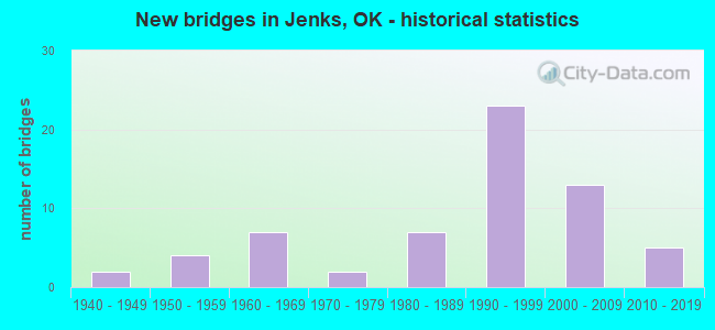
- New bridges - historical statistics
- 21940-1949
- 41950-1959
- 71960-1969
- 21970-1979
- 71980-1989
- 231990-1999
- 132000-2009
- 52010-2019

- Reconstructed bridges - Historical Statistics
- 11950-1959
- 01960-1969
- 11970-1979
- 01980-1989
- 11990-1999
- 22000-2009
- 12010-2019


- Bridge Condition - Deck
- 2.7%Very good
- 75.7%Good
- 18.9%Satisfactory
- 2.7%Fair

- Bridge Condition - Superstructure
- 45.9%Very good
- 32.4%Good
- 10.8%Satisfactory
- 10.8%Fair

- Bridge Condition - Substructure
- 5.4%Very good
- 70.3%Good
- 5.4%Satisfactory
- 16.2%Fair
- 2.7%Poor

- Bridge Condition - Channel
- 6.5%Excellent
- 29.0%Very good
- 38.7%Good
- 6.5%Satisfactory
- 19.4%Fair

- Bridge Condition - Culverts
- 33.3%Very good
- 55.6%Good
- 11.1%Satisfactory
Find on map >> Show street view
Structure Number: 7426, Location: 300' W OF ELM ON 96 ST (Lat: 36.022736, Lng: -95.976683), Route carried "on" structure: City street E0685, Year Built: 1940, Year Reconstructed: 2000, Status: Open, Structure Length: 0.70m (2.30ft), Average Daily Traffic: 14,697 (year 2020), Truck Traffic: 10%, Average Future Daily Traffic: 23,515 (year 2040), Design Load: H 20, Features Intersected: CREEK, Facility Carried by Structure: 96TH(MAIN ST.)
Minimum Vertical Clearance: 30+ m (98+ ft), Kilometerpoint: 5.309, Lanes on structure: 5, Owner: City or Municipal Highway Agency, Maintenance Responsibility: County Highway Agency, Approaching Roadway Width: 12.2m (40.0ft), Material/Design: Concrete, Design/Construction: Culvert, Number Of Spans In Main Unit: 2, Length of Maximum Span: 3.0m (9.8ft), Curb or Sidewalk Widths: Left: 0.0m, Right: 1.8m (5.9ft), Curb-To-Curb Width: 18.7m (61.4ft), Out-to-Out Width: 21.8m (71.5ft)
Condition: Channel: Good, Culverts: Good, Operating Rating: 54.4 metric tons, Method Used To Determine Operating Rating: Load Factor (LF), Inventory Rating: 32.7 metric tons, Method Used To Determine Inventory Rating: Load Factor (LF), Structural Evaluation: Better than present minimum criteria, Deck Geometry: High priority of corrective action, Waterway Adequacy: Equal to present minimum criteria, Approach Roadway Alignment: Equal to present minimum criteria, Length Of Structure Improvement: 2.86m (9.38ft), Designated Inspection Frequency: Every 24 months, Inspection Date: Febuary 2020, Bridge Improvement Cost: $100,000, Roadway Improvement Cost: $75,000, Total Project Cost: $225,000 ( Estimate for 2015)
Find on map >> Show street view
Structure Number: 12685, Location: 121ST S .7E UNION AVE (Lat: 35.988311, Lng: -96.002194), Route carried "on" structure: County highway E0710, Year Built: 1952, Status: Posted for load, Structure Length: 0.76m (2.49ft), Average Daily Traffic: 1,158 (year 2020), Truck Traffic: 5%, Average Future Daily Traffic: 1,853 (year 2040), Design Load: HS 20, Features Intersected: COAL CREEK
Minimum Vertical Clearance: 30+ m (98+ ft), Kilometerpoint: 0.885, Lanes on structure: 2, Owner: County Highway Agency, Approaching Roadway Width: 6.9m (22.6ft), Material/Design: Steel, Design/Construction: Stringer/Multi-beam, Number Of Spans In Main Unit: 1, Length of Maximum Span: 7.0m (23.0ft), Curb-To-Curb Width: 12.1m (39.7ft), Out-to-Out Width: 13.0m (42.7ft)
Condition: Deck: Satisfactory, Superstructure: Fair, Substructure: Fair, Channel: Fair, Operating Rating: 17.2 metric tons, Method Used To Determine Operating Rating: Load Factor (LF), Inventory Rating: 10.0 metric tons, Method Used To Determine Inventory Rating: Load Factor (LF), Structural Evaluation: High priority of replacement, Deck Geometry: Equal to present minimum criteria, Waterway Adequacy: Somewhat better than minimum adequacy, Approach Roadway Alignment: Equal to present desirable criteria, Bridge Posting: Required (Relationship of Operating Rating to Maximum Legal Load: > 39.9% below), Length Of Structure Improvement: 2.98m (9.78ft), Designated Inspection Frequency: Every 24 months, Inspection Date: September 2021, Bridge Improvement Cost: $152,000, Roadway Improvement Cost: $84,000, Total Project Cost: $241,000 ( Estimate for 2015), Deck Structure Type: Concrete Cast-file-Place, Wearing Surface/Protective System: Wearing Surface: Bituminous
Find on map >> Show street view
Structure Number: 13618, Location: 4.7 MI N JCT SH-67 (Lat: 36.013619, Lng: -96.011314), Route carried "on" structure: US 75, Year Built: 1956, Year Reconstructed: 1964, Status: Open, Structure Length: 1.28m (4.20ft), Average Daily Traffic: 46,200 (year 2020), Truck Traffic: 8%, Average Future Daily Traffic: 73,920 (year 2040), Design Load: HS 20, Features Intersected: CREEK
Minimum Vertical Clearance: 30+ m (98+ ft), Kilometerpoint: 7.643, Lanes on structure: 6, Base Highway Network: Yes, Owner: State Highway Agency, Approaching Roadway Width: 13.4m (44.0ft), Material/Design: Concrete, Design/Construction: Culvert, Number Of Spans In Main Unit: 3, Length of Maximum Span: 4.3m (14.1ft)
Condition: Channel: Good, Culverts: Good, Operating Rating: 44.5 metric tons, Method Used To Determine Operating Rating: Load Factor (LF), Inventory Rating: 32.7 metric tons, Method Used To Determine Inventory Rating: Load Factor (LF), Structural Evaluation: Better than present minimum criteria, Waterway Adequacy: Better than present minimum criteria, Approach Roadway Alignment: Equal to present desirable criteria, Length Of Structure Improvement: 1.28m (4.20ft), Designated Inspection Frequency: Every 24 months, Inspection Date: December 2020, Bridge Improvement Cost: $391,000, Roadway Improvement Cost: $645,000, Total Project Cost: $1,095,000 ( Estimate for 2015)
Find on map >> Show street view
Structure Number: 13657, Location: 5.2 MI N JCT SH-67 (Lat: 36.021106, Lng: -96.011739), Route carried "on" structure: US 75, Year Built: 1956, Status: Open, Structure Length: 4.60m (15.09ft), Average Daily Traffic: 24,950 (year 2020), Truck Traffic: 8%, Average Future Daily Traffic: 39,920 (year 2040), Design Load: H 20, Features Intersected: NICKLE CREEK
Minimum Vertical Clearance: 30+ m (98+ ft), Kilometerpoint: 8.480, Lanes on structure: 2, Base Highway Network: Yes, Owner: State Highway Agency, Approaching Roadway Width: 11.6m (38.1ft), Skew: 10 degrees, Material/Design: Steel, Design/Construction: Stringer/Multi-beam, Number Of Spans In Main Unit: 3, Length of Maximum Span: 15.2m (49.9ft), Curb-To-Curb Width: 8.5m (27.9ft), Out-to-Out Width: 9.4m (30.8ft)
Condition: Deck: Good, Superstructure: Good, Substructure: Satisfactory, Channel: Good, Operating Rating: 47.9 metric tons, Method Used To Determine Operating Rating: Load Factor (LF), Inventory Rating: 28.8 metric tons, Method Used To Determine Inventory Rating: Load Factor (LF), Structural Evaluation: Equal to present minimum criteria, Deck Geometry: High priority of replacement, Waterway Adequacy: Somewhat better than minimum adequacy, Approach Roadway Alignment: Equal to present desirable criteria, Length Of Structure Improvement: 7.75m (25.43ft), Designated Inspection Frequency: Every 24 months, Inspection Date: December 2020, Bridge Improvement Cost: $994,000, Roadway Improvement Cost: $1,640,000, Total Project Cost: $2,783,000 ( Estimate for 2015), Deck Structure Type: Concrete Cast-file-Place, Wearing Surface/Protective System: Wearing Surface: Monolithic Concrete, Membrane: Epoxy, Deck Protection: Epoxy Coated Reinforcing
Find on map >> Show street view
Structure Number: 13684, Location: 4.8 MI N JCT SH 67 (Lat: 36.015519, Lng: -96.011756), Route carried "on" structure: US 75, Year Built: 1956, Year Reconstructed: 1977, Status: Open, Structure Length: 14.11m (46.29ft), Average Daily Traffic: 23,100 (year 2020), Truck Traffic: 8%, Average Future Daily Traffic: 36,960 (year 2040), Design Load: H 20, Features Intersected: POLECAT CREEK
Minimum Vertical Clearance: 30+ m (98+ ft), Kilometerpoint: 12.662, Lanes on structure: 2, Base Highway Network: Yes, Owner: State Highway Agency, Approaching Roadway Width: 12.2m (40.0ft), Skew: 13 degrees, Material/Design: Steel continuous, Design/Construction: Stringer/Multi-beam, Number Of Spans In Main Unit: 3, Number Of Approach Spans: 4, Length of Maximum Span: 30.5m (100.1ft), Curb-To-Curb Width: 8.5m (27.9ft), Out-to-Out Width: 9.1m (29.9ft)
Condition: Deck: Satisfactory, Superstructure: Fair, Substructure: Fair, Channel: Fair, Operating Rating: 44.3 metric tons, Method Used To Determine Operating Rating: Load Factor (LF), Inventory Rating: 26.6 metric tons, Method Used To Determine Inventory Rating: Load Factor (LF), Structural Evaluation: Somewhat better than minimum adequacy, Deck Geometry: High priority of corrective action, Waterway Adequacy: Equal to present minimum criteria, Approach Roadway Alignment: Better than present minimum criteria, Length Of Structure Improvement: 14.14m (46.39ft), Designated Inspection Frequency: Every 24 months, Inspection Date: August 2021, Bridge Improvement Cost: $1,814,000, Roadway Improvement Cost: $2,993,000, Total Project Cost: $5,079,000 ( Estimate for 2015), Deck Structure Type: Concrete Cast-file-Place, Wearing Surface/Protective System: Wearing Surface: Low Slump Concrete
Find on map >> Show street view
Structure Number: 16184, Location: 4.8 MI N JCT SH 67 (Lat: 36.015667, Lng: -96.011447), Route carried "on" structure: US 75, Year Built: 1964, Status: Open, Structure Length: 14.11m (46.29ft), Average Daily Traffic: 23,350 (year 2020), Truck Traffic: 8%, Average Future Daily Traffic: 37,360 (year 2040), Design Load: HS 20, Features Intersected: POLECAT CREEK
Minimum Vertical Clearance: 30+ m (98+ ft), Kilometerpoint: 12.662, Lanes on structure: 2, Base Highway Network: Yes, Owner: State Highway Agency, Approaching Roadway Width: 12.2m (40.0ft), Skew: 13 degrees, Material/Design: Steel continuous, Design/Construction: Stringer/Multi-beam, Number Of Spans In Main Unit: 3, Number Of Approach Spans: 4, Length of Maximum Span: 30.5m (100.1ft), Curb-To-Curb Width: 8.5m (27.9ft), Out-to-Out Width: 9.1m (29.9ft)
Condition: Deck: Fair, Superstructure: Fair, Substructure: Fair, Channel: Fair, Operating Rating: 45.5 metric tons, Method Used To Determine Operating Rating: Load Factor (LF), Inventory Rating: 27.3 metric tons, Method Used To Determine Inventory Rating: Load Factor (LF), Structural Evaluation: Somewhat better than minimum adequacy, Deck Geometry: High priority of corrective action, Waterway Adequacy: Equal to present minimum criteria, Approach Roadway Alignment: Better than present minimum criteria, Length Of Structure Improvement: 14.14m (46.39ft), Designated Inspection Frequency: Every 24 months, Inspection Date: August 2021, Bridge Improvement Cost: $1,814,000, Roadway Improvement Cost: $2,993,000, Total Project Cost: $5,079,000 ( Estimate for 2015), Deck Structure Type: Concrete Cast-file-Place, Wearing Surface/Protective System: Wearing Surface: Low Slump Concrete
Find on map >> Show street view
Structure Number: 16531, Location: 5.2 MI N JCT SH-67 (Lat: 36.021108, Lng: -96.011814), Route carried "on" structure: Ramp US 75, Year Built: 1965, Status: Open, Structure Length: 4.60m (15.09ft), Average Daily Traffic: 15,000 (year 2020), Truck Traffic: 8%, Average Future Daily Traffic: 24,000 (year 2040), Design Load: HS 20, Features Intersected: NICKLE CREEK
Minimum Vertical Clearance: 30+ m (98+ ft), Kilometerpoint: 8.480, Lanes on structure: 1, Owner: State Highway Agency, Approaching Roadway Width: 6.1m (20.0ft), Skew: 10 degrees, Material/Design: Steel, Design/Construction: Stringer/Multi-beam, Number Of Spans In Main Unit: 3, Length of Maximum Span: 15.2m (49.9ft), Curb-To-Curb Width: 5.5m (18.0ft), Out-to-Out Width: 6.4m (21.0ft)
Condition: Deck: Satisfactory, Superstructure: Good, Substructure: Good, Channel: Good, Operating Rating: 68.4 metric tons, Method Used To Determine Operating Rating: Load Factor (LF), Inventory Rating: 41.0 metric tons, Method Used To Determine Inventory Rating: Load Factor (LF), Structural Evaluation: Better than present minimum criteria, Deck Geometry: Meets minimum limits, Waterway Adequacy: Somewhat better than minimum adequacy, Approach Roadway Alignment: Equal to present desirable criteria, Length Of Structure Improvement: 5.06m (16.60ft), Designated Inspection Frequency: Every 24 months, Inspection Date: December 2020, Bridge Improvement Cost: $649,000, Roadway Improvement Cost: $1,071,000, Total Project Cost: $1,817,000 ( Estimate for 2015), Deck Structure Type: Concrete Cast-file-Place, Wearing Surface/Protective System: Wearing Surface: Monolithic Concrete
Find on map >> Show street view
Structure Number: 16532, Location: 5.2 MI N JCT SH-67 (Lat: 36.021106, Lng: -96.011417), Route carried "on" structure: US 75, Year Built: 1965, Status: Open, Structure Length: 4.60m (15.09ft), Average Daily Traffic: 23,350 (year 2020), Truck Traffic: 8%, Average Future Daily Traffic: 37,360 (year 2040), Design Load: HS 20, Features Intersected: NICKLE CREEK
Minimum Vertical Clearance: 30+ m (98+ ft), Kilometerpoint: 8.480, Lanes on structure: 2, Base Highway Network: Yes, Owner: State Highway Agency, Approaching Roadway Width: 11.6m (38.1ft), Skew: 10 degrees, Material/Design: Steel, Design/Construction: Stringer/Multi-beam, Number Of Spans In Main Unit: 3, Length of Maximum Span: 15.2m (49.9ft), Curb-To-Curb Width: 11.0m (36.1ft), Out-to-Out Width: 11.6m (38.1ft)
Condition: Deck: Satisfactory, Superstructure: Satisfactory, Substructure: Good, Channel: Good, Operating Rating: 80.0 metric tons, Method Used To Determine Operating Rating: Load Factor (LF), Inventory Rating: 48.0 metric tons, Method Used To Determine Inventory Rating: Load Factor (LF), Structural Evaluation: Equal to present minimum criteria, Deck Geometry: Somewhat better than minimum adequacy, Waterway Adequacy: Somewhat better than minimum adequacy, Approach Roadway Alignment: Equal to present desirable criteria, Length Of Structure Improvement: 7.75m (25.43ft), Designated Inspection Frequency: Every 24 months, Inspection Date: December 2020, Bridge Improvement Cost: $994,000, Roadway Improvement Cost: $1,640,000, Total Project Cost: $2,783,000 ( Estimate for 2015), Deck Structure Type: Concrete Cast-file-Place, Wearing Surface/Protective System: Wearing Surface: Monolithic Concrete
Find on map >> Show street view
Structure Number: 16545, Location: 0.8 MI S OF 96 ST SOUTH (Lat: 36.012569, Lng: -95.975939), Route carried "on" structure: City street 8301, Year Built: 1965, Year Reconstructed: 1990, Status: Open, Structure Length: 9.45m (31.00ft), Average Daily Traffic: 6,747 (year 2020), Truck Traffic: 10%, Average Future Daily Traffic: 10,795 (year 2040), Design Load: HS 20, Features Intersected: POLECAT CREEK
Minimum Vertical Clearance: 30+ m (98+ ft), Kilometerpoint: 4.344, Lanes on structure: 2, Owner: City or Municipal Highway Agency, Maintenance Responsibility: County Highway Agency, Approaching Roadway Width: 6.7m (22.0ft), Skew: 10 degrees, Material/Design: Steel continuous, Design/Construction: Stringer/Multi-beam, Number Of Spans In Main Unit: 3, Number Of Approach Spans: 2, Length of Maximum Span: 33.5m (109.9ft), Curb-To-Curb Width: 9.8m (32.2ft), Out-to-Out Width: 10.6m (34.8ft)
Condition: Deck: Satisfactory, Superstructure: Good, Substructure: Good, Channel: Good, Operating Rating: 44.5 metric tons, Method Used To Determine Operating Rating: Allowable Stress (AS), Inventory Rating: 32.7 metric tons, Method Used To Determine Inventory Rating: Allowable Stress (AS), Structural Evaluation: Better than present minimum criteria, Deck Geometry: Meets minimum limits, Waterway Adequacy: Equal to present desirable criteria, Approach Roadway Alignment: Equal to present desirable criteria, Length Of Structure Improvement: 11.35m (37.24ft), Designated Inspection Frequency: Every 24 months, Inspection Date: Febuary 2020, Bridge Improvement Cost: $580,000, Roadway Improvement Cost: $319,000, Total Project Cost: $907,000 ( Estimate for 2015), Deck Structure Type: Concrete Cast-file-Place, Wearing Surface/Protective System: Wearing Surface: Monolithic Concrete
Find on map >> Show street view
Structure Number: 16561, Location: 5.5 MI N JCT SH 67 (Lat: 36.024722, Lng: -96.011111), Route carried "on" structure: County highway , Year Built: 1965, Status: Open, Structure Length: 5.39m (17.68ft), Average Daily Traffic: 5,000 (year 2020), Truck Traffic: 5%, Average Future Daily Traffic: 8,000 (year 2040), Design Load: HS 20, Features Intersected: U.S. 75 UNDER, Facility Carried by Structure: JENKS RD.
Minimum Vertical Clearance: 30+ m (98+ ft), Kilometerpoint: 8.866, Lanes on structure: 2, Lanes under structure: 4, Owner: State Highway Agency, Approaching Roadway Width: 8.5m (27.9ft), Material/Design: Concrete continuous, Design/Construction: Slab, Number Of Spans In Main Unit: 4, Length of Maximum Span: 17.1m (56.1ft), Curb or Sidewalk Widths: Left: 0.5m (1.6ft), Right: 0.5m (1.6ft), Curb-To-Curb Width: 8.5m (27.9ft), Out-to-Out Width: 9.4m (30.8ft)
Condition: Deck: Satisfactory, Superstructure: Good, Substructure: Good, Operating Rating: 53.2 metric tons, Method Used To Determine Operating Rating: Load Factor (LF), Inventory Rating: 31.8 metric tons, Method Used To Determine Inventory Rating: Load Factor (LF), Structural Evaluation: Better than present minimum criteria, Deck Geometry: Meets minimum limits, Underclear: High priority of replacement, Approach Roadway Alignment: Equal to present desirable criteria, Length Of Structure Improvement: 7.20m (23.62ft), Designated Inspection Frequency: Every 24 months, Inspection Date: December 2020, Bridge Improvement Cost: $1,755,000, Roadway Improvement Cost: $2,896,000, Total Project Cost: $4,914,000 ( Estimate for 2015), Deck Structure Type: Concrete Cast-file-Place, Wearing Surface/Protective System: Wearing Surface: Monolithic Concrete
Find on map >> Show street view
Structure Number: 17877, Location: 0.1 MI W OF ELWOOD ON 111 (Lat: 36.002831, Lng: -95.995419), Route carried "on" structure: City street 8140, Year Built: 1970, Status: Open, Structure Length: 3.41m (11.19ft), Average Daily Traffic: 1,639 (year 2020), Truck Traffic: 10%, Average Future Daily Traffic: 2,622 (year 2040), Design Load: HS 20, Features Intersected: COAL CREEK
Minimum Vertical Clearance: 30+ m (98+ ft), Kilometerpoint: 1.448, Lanes on structure: 2, Owner: City or Municipal Highway Agency, Maintenance Responsibility: County Highway Agency, Approaching Roadway Width: 9.8m (32.2ft), Material/Design: Steel, Design/Construction: Stringer/Multi-beam, Number Of Spans In Main Unit: 2, Length of Maximum Span: 15.8m (51.8ft), Curb-To-Curb Width: 8.5m (27.9ft), Out-to-Out Width: 9.4m (30.8ft)
Condition: Deck: Satisfactory, Superstructure: Fair, Substructure: Fair, Channel: Fair, Operating Rating: 46.3 metric tons, Method Used To Determine Operating Rating: Load Factor (LF), Inventory Rating: 28.1 metric tons, Method Used To Determine Inventory Rating: Load Factor (LF), Structural Evaluation: Somewhat better than minimum adequacy, Deck Geometry: Somewhat better than minimum adequacy, Waterway Adequacy: Equal to present minimum criteria, Approach Roadway Alignment: Equal to present minimum criteria, Length Of Structure Improvement: 6.61m (21.69ft), Designated Inspection Frequency: Every 24 months, Inspection Date: Febuary 2020, Bridge Improvement Cost: $338,000, Roadway Improvement Cost: $186,000, Total Project Cost: $539,000 ( Estimate for 2015), Deck Structure Type: Concrete Cast-file-Place, Wearing Surface/Protective System: Wearing Surface: Bituminous
Find on map >> Show street view
Structure Number: 19019, Location: 0.8 MI S OF 101 ST (Lat: 36.006797, Lng: -95.993889), Route carried "on" structure: City street N3940, Year Built: 1975, Status: Open, Structure Length: 3.11m (10.20ft), Average Daily Traffic: 1,588 (year 2020), Truck Traffic: 10%, Average Future Daily Traffic: 2,541 (year 2040), Design Load: HS 20, Features Intersected: COAL CREEK
Minimum Vertical Clearance: 30+ m (98+ ft), Kilometerpoint: 1.127, Lanes on structure: 2, Owner: City or Municipal Highway Agency, Maintenance Responsibility: County Highway Agency, Approaching Roadway Width: 11.0m (36.1ft), Material/Design: Prestressed concrete, Design/Construction: Stringer/Multi-beam, Number Of Spans In Main Unit: 2, Length of Maximum Span: 20.4m (66.9ft), Curb-To-Curb Width: 9.1m (29.9ft), Out-to-Out Width: 10.1m (33.1ft)
Condition: Deck: Good, Superstructure: Good, Substructure: Fair, Channel: Fair, Operating Rating: 44.5 metric tons, Method Used To Determine Operating Rating: Load Factor (LF), Inventory Rating: 32.7 metric tons, Method Used To Determine Inventory Rating: Load Factor (LF), Structural Evaluation: Somewhat better than minimum adequacy, Deck Geometry: Somewhat better than minimum adequacy, Waterway Adequacy: Equal to present minimum criteria, Approach Roadway Alignment: Better than present minimum criteria, Length Of Structure Improvement: 6.30m (20.67ft), Designated Inspection Frequency: Every 24 months, Inspection Date: Febuary 2020, Bridge Improvement Cost: $322,000, Roadway Improvement Cost: $177,000, Total Project Cost: $514,000 ( Estimate for 2015), Deck Structure Type: Concrete Cast-file-Place, Wearing Surface/Protective System: Wearing Surface: Bituminous
Find on map >> Show street view
Structure Number: 19986, Location: 3.0 MI N SH 67 (Lat: 35.988086, Lng: -96.011875), Route carried "on" structure: US 75, Year Built: 1981, Status: Open, Structure Length: 5.91m (19.39ft), Average Daily Traffic: 21,050 (year 2020), Truck Traffic: 7%, Average Future Daily Traffic: 33,680 (year 2040), Design Load: HS 20, Features Intersected: S.H. 117 UNDER
Minimum Vertical Clearance: 30+ m (98+ ft), Kilometerpoint: 7.768, Lanes on structure: 2, Lanes under structure: 4, Base Highway Network: Yes, Owner: State Highway Agency, Approaching Roadway Width: 12.2m (40.0ft), Skew: 10 degrees, Material/Design: Concrete continuous, Design/Construction: Box Beam or Girders - Multiple, Number Of Spans In Main Unit: 2, Length of Maximum Span: 30.5m (100.1ft), Curb-To-Curb Width: 12.5m (41.0ft), Out-to-Out Width: 13.4m (44.0ft)
Condition: Deck: Good, Superstructure: Satisfactory, Substructure: Good, Operating Rating: 44.1 metric tons, Method Used To Determine Operating Rating: Allowable Stress (AS), Inventory Rating: 32.5 metric tons, Method Used To Determine Inventory Rating: Allowable Stress (AS), Structural Evaluation: Equal to present minimum criteria, Deck Geometry: Better than present minimum criteria, Underclear: Somewhat better than minimum adequacy, Approach Roadway Alignment: Equal to present desirable criteria, Length Of Structure Improvement: 6.50m (21.33ft), Designated Inspection Frequency: Every 24 months, Inspection Date: December 2020, Bridge Improvement Cost: $834,000, Roadway Improvement Cost: $1,376,000, Total Project Cost: $2,335,000 ( Estimate for 2015), Deck Structure Type: Concrete Cast-file-Place, Wearing Surface/Protective System: Wearing Surface: Low Slump Concrete
Find on map >> Show street view
Structure Number: 19987, Location: 3.0 MI N SH 67 (Lat: 35.988083, Lng: -96.011500), Route carried "on" structure: US 75, Year Built: 1981, Status: Open, Structure Length: 5.91m (19.39ft), Average Daily Traffic: 21,350 (year 2020), Truck Traffic: 7%, Average Future Daily Traffic: 34,160 (year 2040), Design Load: HS 20, Features Intersected: S.H. 117 UNDER
Minimum Vertical Clearance: 30+ m (98+ ft), Kilometerpoint: 7.768, Lanes on structure: 2, Lanes under structure: 4, Base Highway Network: Yes, Owner: State Highway Agency, Approaching Roadway Width: 12.2m (40.0ft), Skew: 10 degrees, Material/Design: Concrete continuous, Design/Construction: Box Beam or Girders - Multiple, Number Of Spans In Main Unit: 2, Length of Maximum Span: 30.5m (100.1ft), Curb-To-Curb Width: 12.5m (41.0ft), Out-to-Out Width: 13.4m (44.0ft)
Condition: Deck: Good, Superstructure: Satisfactory, Substructure: Good, Operating Rating: 44.1 metric tons, Method Used To Determine Operating Rating: Allowable Stress (AS), Inventory Rating: 32.5 metric tons, Method Used To Determine Inventory Rating: Allowable Stress (AS), Structural Evaluation: Equal to present minimum criteria, Deck Geometry: Better than present minimum criteria, Underclear: Somewhat better than minimum adequacy, Approach Roadway Alignment: Equal to present desirable criteria, Length Of Structure Improvement: 6.50m (21.33ft), Designated Inspection Frequency: Every 24 months, Inspection Date: December 2020, Bridge Improvement Cost: $834,000, Roadway Improvement Cost: $1,377,000, Total Project Cost: $2,336,000 ( Estimate for 2015), Deck Structure Type: Concrete Cast-file-Place, Wearing Surface/Protective System: Wearing Surface: Low Slump Concrete
Find on map >> Show street view
Structure Number: 20465, Location: 111ST .1E 33RD W AVE (Lat: 36.002850, Lng: -96.027550), Route carried "on" structure: County highway N3920, Year Built: 1983, Status: Open, Structure Length: 1.58m (5.18ft), Average Daily Traffic: 150 (year 2020), Truck Traffic: 10%, Average Future Daily Traffic: 240 (year 2040), Design Load: HS 20, Features Intersected: CREEK, Facility Carried by Structure: E0700(W.111TH.ST.)
Minimum Vertical Clearance: 30+ m (98+ ft), Kilometerpoint: 1.448, Lanes on structure: 2, Owner: County Highway Agency, Approaching Roadway Width: 6.4m (21.0ft), Material/Design: Prestressed concrete, Design/Construction: Tee Beam, Number Of Spans In Main Unit: 1, Length of Maximum Span: 14.9m (48.9ft), Curb-To-Curb Width: 9.7m (31.8ft), Out-to-Out Width: 10.5m (34.4ft)
Condition: Deck: Good, Superstructure: Satisfactory, Substructure: Poor, Channel: Fair, Operating Rating: 42.6 metric tons, Method Used To Determine Operating Rating: Load Factor (LF), Inventory Rating: 32.7 metric tons, Method Used To Determine Inventory Rating: Load Factor (LF), Structural Evaluation: Meets minimum limits, Deck Geometry: Equal to present minimum criteria, Waterway Adequacy: Better than present minimum criteria, Approach Roadway Alignment: Equal to present desirable criteria, Length Of Structure Improvement: 4.40m (14.44ft), Designated Inspection Frequency: Every 24 months, Inspection Date: September 2021, Bridge Improvement Cost: $225,000, Roadway Improvement Cost: $124,000, Total Project Cost: $357,000 ( Estimate for 2015), Deck Structure Type: Concrete Precast Panels, Wearing Surface/Protective System: Wearing Surface: Bituminous
Find on map >> Show street view
Structure Number: 20741, Location: 141ST S. .8E LEWIS AVE (Lat: 35.959286, Lng: -95.943653), Route carried "on" structure: County highway E0730, Year Built: 1984, Status: Open, Structure Length: 1.55m (5.09ft), Average Daily Traffic: 375 (year 2020), Truck Traffic: 10%, Average Future Daily Traffic: 600 (year 2040), Design Load: HS 20, Features Intersected: POSEY CREEK
Minimum Vertical Clearance: 30+ m (98+ ft), Kilometerpoint: 1.287, Lanes on structure: 2, Owner: County Highway Agency, Approaching Roadway Width: 6.6m (21.7ft), Material/Design: Prestressed concrete, Design/Construction: Tee Beam, Number Of Spans In Main Unit: 1, Length of Maximum Span: 14.1m (46.3ft), Curb-To-Curb Width: 9.8m (32.2ft), Out-to-Out Width: 10.4m (34.1ft)
Condition: Deck: Good, Superstructure: Good, Substructure: Good, Channel: Satisfactory, Operating Rating: 44.5 metric tons, Method Used To Determine Operating Rating: Allowable Stress (AS), Inventory Rating: 32.7 metric tons, Method Used To Determine Inventory Rating: Allowable Stress (AS), Structural Evaluation: Better than present minimum criteria, Deck Geometry: Better than present minimum criteria, Waterway Adequacy: Somewhat better than minimum adequacy, Approach Roadway Alignment: Equal to present desirable criteria, Length Of Structure Improvement: 4.35m (14.27ft), Designated Inspection Frequency: Every 24 months, Inspection Date: November 2021, Bridge Improvement Cost: $222,000, Roadway Improvement Cost: $122,000, Total Project Cost: $354,000 ( Estimate for 2015), Deck Structure Type: Concrete Precast Panels, Wearing Surface/Protective System: Wearing Surface: Bituminous
Find on map >> Show street view
Structure Number: 22412, Location: 0.8 MI S OF 131 ST (Lat: 35.963314, Lng: -95.930244), Route carried "on" structure: City street N3976, Year Built: 1989, Status: Open, Structure Length: 17.56m (57.61ft), Average Daily Traffic: 1,100 (year 2020), Truck Traffic: 10%, Average Future Daily Traffic: 1,760 (year 2040), Design Load: HS 20, Features Intersected: POSEY CREEK
Minimum Vertical Clearance: 30+ m (98+ ft), Kilometerpoint: 1.287, Lanes on structure: 2, Owner: City or Municipal Highway Agency, Maintenance Responsibility: County Highway Agency, Approaching Roadway Width: 8.6m (28.2ft), Material/Design: Prestressed concrete, Design/Construction: Stringer/Multi-beam, Number Of Spans In Main Unit: 9, Length of Maximum Span: 22.9m (75.1ft), Curb-To-Curb Width: 10.0m (32.8ft), Out-to-Out Width: 10.5m (34.4ft)
Condition: Deck: Good, Superstructure: Good, Substructure: Fair, Channel: Satisfactory, Operating Rating: 44.5 metric tons, Method Used To Determine Operating Rating: Load Factor (LF), Inventory Rating: 32.7 metric tons, Method Used To Determine Inventory Rating: Load Factor (LF), Structural Evaluation: Somewhat better than minimum adequacy, Deck Geometry: Somewhat better than minimum adequacy, Waterway Adequacy: Better than present minimum criteria, Approach Roadway Alignment: Better than present minimum criteria, Length Of Structure Improvement: 17.56m (57.61ft), Designated Inspection Frequency: Every 24 months, Inspection Date: Febuary 2020, Bridge Improvement Cost: $897,000, Roadway Improvement Cost: $480,000, Total Project Cost: $1,400,000 ( Estimate for 2015), Deck Structure Type: Concrete Cast-file-Place, Wearing Surface/Protective System: Wearing Surface: Monolithic Concrete, Deck Protection: Epoxy Coated Reinforcing
Find on map >> Show street view
Structure Number: 22774, Location: 07.75 (Lat: 36.016550, Lng: -95.963039), Route carried "on" structure: Other road , Year Built: 1991, Status: Open, Structure Length: 1.10m (3.61ft), Average Daily Traffic: 43,800 (year 2020), Truck Traffic: 8%, Average Future Daily Traffic: 70,080 (year 2040), Design Load: HS 20, Features Intersected: LEWIS AVE ACCESS UNDER, Facility Carried by Structure: CREEK TP
Minimum Vertical Clearance: 30+ m (98+ ft), Kilometerpoint: 4.810, Lanes on structure: 6, Lanes under structure: 2, Base Highway Network: Yes, Toll: On toll road, Owner: State Toll Authority, Approaching Roadway Width: 35.4m (116.1ft), Skew: 10 degrees, Material/Design: Concrete, Design/Construction: Slab, Number Of Spans In Main Unit: 1, Length of Maximum Span: 11.0m (36.1ft), Curb-To-Curb Width: 36.0m (118.1ft), Out-to-Out Width: 36.9m (121.1ft)
Condition: Deck: Good, Superstructure: Good, Substructure: Good, Operating Rating: 61.7 metric tons, Method Used To Determine Operating Rating: Load Factor (LF), Inventory Rating: 32.7 metric tons, Method Used To Determine Inventory Rating: Load Factor (LF), Structural Evaluation: Better than present minimum criteria, Deck Geometry: Superior to present desirable criteria, Underclear: High priority of corrective action, Approach Roadway Alignment: Equal to present desirable criteria, Length Of Structure Improvement: 1.25m (4.10ft), Designated Inspection Frequency: Every 24 months, Inspection Date: July 2020, Bridge Improvement Cost: $230,000, Roadway Improvement Cost: $345,000, Total Project Cost: $671,000 ( Estimate for 2015), Deck Structure Type: Concrete Cast-file-Place, Wearing Surface/Protective System: Wearing Surface: Integral Concrete
Find on map >> Show street view
Structure Number: 22916, Location: 07.02S (Lat: 36.016372, Lng: -95.976281), Route carried "on" structure: Other road , Year Built: 1991, Status: Open, Structure Length: 7.35m (24.11ft), Average Daily Traffic: 21,900 (year 2020), Truck Traffic: 8%, Average Future Daily Traffic: 35,040 (year 2040), Design Load: HS 20, Features Intersected: ELM ST. UNDER, Facility Carried by Structure: CREEK TP
Minimum Vertical Clearance: 30+ m (98+ ft), Kilometerpoint: 3.557, Lanes on structure: 3, Lanes under structure: 6, Base Highway Network: Yes, Toll: On toll road, Owner: State Toll Authority, Approaching Roadway Width: 12.8m (42.0ft), Skew: 10 degrees, Material/Design: Prestressed concrete continuous, Design/Construction: Stringer/Multi-beam, Number Of Spans In Main Unit: 3, Length of Maximum Span: 30.5m (100.1ft), Curb-To-Curb Width: 16.9m (55.4ft), Out-to-Out Width: 17.8m (58.4ft)
Condition: Deck: Good, Superstructure: Very good, Substructure: Good, Operating Rating: 84.4 metric tons, Method Used To Determine Operating Rating: Load Factor (LF), Inventory Rating: 32.7 metric tons, Method Used To Determine Inventory Rating: Load Factor (LF), Structural Evaluation: Better than present minimum criteria, Deck Geometry: Equal to present minimum criteria, Underclear: Meets minimum limits, Approach Roadway Alignment: Equal to present desirable criteria, Length Of Structure Improvement: 7.35m (24.11ft), Designated Inspection Frequency: Every 24 months, Inspection Date: August 2020, Bridge Improvement Cost: $566,000, Roadway Improvement Cost: $849,000, Total Project Cost: $1,622,000 ( Estimate for 2015), Deck Structure Type: Concrete Cast-file-Place, Wearing Surface/Protective System: Wearing Surface: Monolithic Concrete, Deck Protection: Epoxy Coated Reinforcing
Find on map >> Show street view
Structure Number: 22927, Location: 07.48S (Lat: 36.016561, Lng: -95.968181), Route carried "on" structure: Other road , Year Built: 1991, Status: Open, Structure Length: 8.87m (29.10ft), Average Daily Traffic: 21,900 (year 2020), Truck Traffic: 8%, Average Future Daily Traffic: 35,040 (year 2040), Design Load: HS 20, Features Intersected: M.P. R.R. & STREET UNDER, Facility Carried by Structure: CREEK TP
Minimum Vertical Clearance: 30+ m (98+ ft), Kilometerpoint: 4.279, Lanes on structure: 2, Lanes under structure: 5, Base Highway Network: Yes, Toll: On toll road, Owner: State Toll Authority, Approaching Roadway Width: 13.7m (44.9ft), Skew: 10 degrees, Material/Design: Prestressed concrete, Design/Construction: Stringer/Multi-beam, Number Of Spans In Main Unit: 3, Length of Maximum Span: 29.6m (97.1ft), Curb-To-Curb Width: 17.7m (58.1ft), Out-to-Out Width: 18.7m (61.4ft)
Condition: Deck: Good, Superstructure: Very good, Substructure: Good, Operating Rating: 81.6 metric tons, Method Used To Determine Operating Rating: Load Factor (LF), Inventory Rating: 32.7 metric tons, Method Used To Determine Inventory Rating: Load Factor (LF), Structural Evaluation: Better than present minimum criteria, Deck Geometry: Superior to present desirable criteria, Underclear: High priority of replacement, Approach Roadway Alignment: Equal to present desirable criteria, Length Of Structure Improvement: 8.87m (29.10ft), Designated Inspection Frequency: Every 24 months, Inspection Date: July 2020, Bridge Improvement Cost: $3,141,000, Roadway Improvement Cost: $2,500,000, Total Project Cost: $6,417,000 ( Estimate for 2015), Deck Structure Type: Concrete Cast-file-Place, Wearing Surface/Protective System: Wearing Surface: Monolithic Concrete
Find on map >> Show street view
Structure Number: 22949, Location: 05.88S (Lat: 36.009172, Lng: -95.994139), Route carried "on" structure: Other road , Year Built: 1991, Status: Open, Structure Length: 22.28m (73.10ft), Average Daily Traffic: 16,850 (year 2020), Truck Traffic: 8%, Average Future Daily Traffic: 26,960 (year 2040), Design Load: HS 20, Features Intersected: ELMWOOD ST & COAL CREEK, Facility Carried by Structure: CREEK TP
Minimum Vertical Clearance: 30+ m (98+ ft), Kilometerpoint: 1.786, Lanes on structure: 2, Lanes under structure: 2, Base Highway Network: Yes, Toll: On toll road, Owner: State Toll Authority, Approaching Roadway Width: 12.8m (42.0ft), Skew: 10 degrees, Material/Design: Prestressed concrete, Design/Construction: Stringer/Multi-beam, Number Of Spans In Main Unit: 9, Length of Maximum Span: 30.8m (101.0ft), Curb-To-Curb Width: 11.6m (38.1ft), Out-to-Out Width: 17.8m (58.4ft)
Condition: Deck: Good, Superstructure: Very good, Substructure: Good, Channel: Good, Operating Rating: 44.5 metric tons, Method Used To Determine Operating Rating: Allowable Stress (AS), Inventory Rating: 32.7 metric tons, Method Used To Determine Inventory Rating: Allowable Stress (AS), Structural Evaluation: Better than present minimum criteria, Deck Geometry: Equal to present minimum criteria, Underclear: Meets minimum limits, Waterway Adequacy: Superior to present desirable criteria, Approach Roadway Alignment: Equal to present desirable criteria, Length Of Structure Improvement: 22.28m (73.10ft), Designated Inspection Frequency: Every 24 months, Inspection Date: August 2020, Bridge Improvement Cost: $1,715,000, Roadway Improvement Cost: $1,250,000, Total Project Cost: $3,380,000 ( Estimate for 2015), Deck Structure Type: Concrete Cast-file-Place, Wearing Surface/Protective System: Wearing Surface: Monolithic Concrete, Deck Protection: Epoxy Coated Reinforcing
Find on map >> Show street view
Structure Number: 22957, Location: 08.13S (Lat: 36.017064, Lng: -95.956150), Route carried "on" structure: Other road , Year Built: 1991, Year Reconstructed: 2017, Status: Open, Structure Length: 71.38m (234.19ft), Average Daily Traffic: 21,900 (year 2020), Truck Traffic: 8%, Average Future Daily Traffic: 35,040 (year 2040), Design Load: HS 20, Features Intersected: ARK RIVER & DELAWARE AVE, Facility Carried by Structure: CREEK TP
Minimum Vertical Clearance: 30+ m (98+ ft), Kilometerpoint: 9.167, Lanes on structure: 3, Lanes under structure: 8, Base Highway Network: Yes, Toll: On toll road, Owner: State Toll Authority, Approaching Roadway Width: 14.6m (47.9ft), Skew: 20 degrees, Material/Design: Prestressed concrete, Design/Construction: Stringer/Multi-beam, Number Of Spans In Main Unit: 24, Length of Maximum Span: 30.5m (100.1ft), Curb-To-Curb Width: 16.9m (55.4ft), Out-to-Out Width: 17.9m (58.7ft)
Condition: Deck: Good, Superstructure: Very good, Substructure: Good, Channel: Very good, Operating Rating: 79.8 metric tons, Method Used To Determine Operating Rating: Load Factor (LF), Inventory Rating: 32.7 metric tons, Method Used To Determine Inventory Rating: Load Factor (LF), Structural Evaluation: Better than present minimum criteria, Deck Geometry: Equal to present minimum criteria, Underclear: Equal to present desirable criteria, Waterway Adequacy: Equal to present desirable criteria, Approach Roadway Alignment: Equal to present desirable criteria, Length Of Structure Improvement: 71.38m (234.19ft), Designated Inspection Frequency: Every 24 months, Inspection Date: March 2020, Bridge Improvement Cost: $5,494,000, Roadway Improvement Cost: $1,875,000, Total Project Cost: $8,377,000 ( Estimate for 2015), Deck Structure Type: Concrete Cast-file-Place, Wearing Surface/Protective System: Wearing Surface: Monolithic Concrete, Deck Protection: Epoxy Coated Reinforcing
Find on map >> Show street view
Structure Number: 23053, Location: 04.81 (Lat: 36.011317, Lng: -96.012058), Route carried "on" structure: Ramp Other road , Year Built: 1992, Status: Open, Structure Length: 8.29m (27.20ft), Average Daily Traffic: 9,000 (year 2020), Truck Traffic: 8%, Average Future Daily Traffic: 14,400 (year 2040), Design Load: HS 20, Features Intersected: U.S. 75 SB UNDER, Facility Carried by Structure: CREEK TP RAMP
Minimum Vertical Clearance: 30+ m (98+ ft), Kilometerpoint: 0.064, Lanes on structure: 1, Lanes under structure: 5, Toll: On toll road, Owner: State Toll Authority, Approaching Roadway Width: 8.5m (27.9ft), Material/Design: Prestressed concrete, Design/Construction: Stringer/Multi-beam, Number Of Spans In Main Unit: 4, Length of Maximum Span: 24.7m (81.0ft), Curb-To-Curb Width: 7.6m (24.9ft), Out-to-Out Width: 8.5m (27.9ft)
Condition: Deck: Good, Superstructure: Good, Substructure: Good, Operating Rating: 44.5 metric tons, Method Used To Determine Operating Rating: Allowable Stress (AS), Inventory Rating: 32.7 metric tons, Method Used To Determine Inventory Rating: Allowable Stress (AS), Structural Evaluation: Better than present minimum criteria, Deck Geometry: Better than present minimum criteria, Underclear: Meets minimum limits, Approach Roadway Alignment: Better than present minimum criteria, Length Of Structure Improvement: 8.29m (27.20ft), Designated Inspection Frequency: Every 24 months, Inspection Date: August 2020, Bridge Improvement Cost: $1,595,000, Roadway Improvement Cost: $1,250,000, Total Project Cost: $3,245,000 ( Estimate for 2015), Deck Structure Type: Concrete Cast-file-Place, Wearing Surface/Protective System: Wearing Surface: Monolithic Concrete
Find on map >> Show street view
Structure Number: 2312, Location: 06.67S (Lat: 36.014594, Lng: -95.982508), Route carried "on" structure: Other road , Year Built: 1991, Status: Open, Structure Length: 15.30m (50.20ft), Average Daily Traffic: 16,850 (year 2020), Truck Traffic: 8%, Average Future Daily Traffic: 26,960 (year 2040), Design Load: HS 20, Features Intersected: POLECAT CREEK, Facility Carried by Structure: CREEK TP
Minimum Vertical Clearance: 30+ m (98+ ft), Kilometerpoint: 2.977, Lanes on structure: 3, Base Highway Network: Yes, Toll: On toll road, Owner: State Toll Authority, Approaching Roadway Width: 13.7m (44.9ft), Skew: 22 degrees, Material/Design: Prestressed concrete, Design/Construction: Stringer/Multi-beam, Number Of Spans In Main Unit: 5, Length of Maximum Span: 30.8m (101.0ft), Curb-To-Curb Width: 16.9m (55.4ft), Out-to-Out Width: 17.8m (58.4ft)
Condition: Deck: Good, Superstructure: Very good, Substructure: Good, Channel: Very good, Operating Rating: 78.0 metric tons, Method Used To Determine Operating Rating: Load Factor (LF), Inventory Rating: 32.7 metric tons, Method Used To Determine Inventory Rating: Load Factor (LF), Structural Evaluation: Better than present minimum criteria, Deck Geometry: Equal to present minimum criteria, Waterway Adequacy: Equal to present desirable criteria, Approach Roadway Alignment: Equal to present desirable criteria, Length Of Structure Improvement: 15.30m (50.20ft), Designated Inspection Frequency: Every 24 months, Inspection Date: August 2020, Bridge Improvement Cost: $1,178,000, Roadway Improvement Cost: $1,767,000, Total Project Cost: $3,358,000 ( Estimate for 2015), Deck Structure Type: Concrete Cast-file-Place, Wearing Surface/Protective System: Wearing Surface: Monolithic Concrete, Deck Protection: Epoxy Coated Reinforcing
Find on map >> Show street view
Structure Number: 23125, Location: 05.47 (Lat: 36.009208, Lng: -96.000486), Route carried "on" structure: Other road , Year Built: 1991, Status: Open, Structure Length: 0.88m (2.89ft), Average Daily Traffic: 53,400 (year 2020), Truck Traffic: 8%, Average Future Daily Traffic: 85,440 (year 2040), Design Load: HS 20, Features Intersected: CREEK, Facility Carried by Structure: CREEK TP
Minimum Vertical Clearance: 30+ m (98+ ft), Kilometerpoint: 11.264, Lanes on structure: 6, Base Highway Network: Yes, Toll: On toll road, Owner: State Toll Authority, Approaching Roadway Width: 35.4m (116.1ft), Skew: 26 degrees, Material/Design: Concrete, Design/Construction: Culvert, Number Of Spans In Main Unit: 2, Length of Maximum Span: 3.7m (12.1ft), Curb-To-Curb Width: 71.0m (232.9ft), Out-to-Out Width: 71.6m (234.9ft)
Condition: Channel: Good, Culverts: Very good, Operating Rating: 44.5 metric tons, Method Used To Determine Operating Rating: Allowable Stress (AS), Inventory Rating: 32.7 metric tons, Method Used To Determine Inventory Rating: Allowable Stress (AS), Structural Evaluation: Equal to present desirable criteria, Deck Geometry: Superior to present desirable criteria, Waterway Adequacy: Equal to present desirable criteria, Approach Roadway Alignment: Equal to present desirable criteria, Length Of Structure Improvement: 3.22m (10.56ft), Designated Inspection Frequency: Every 24 months, Inspection Date: August 2020, Bridge Improvement Cost: $200,000, Roadway Improvement Cost: $150,000, Total Project Cost: $360,000 ( Estimate for 2015)
Find on map >> Show street view
Structure Number: 23928, Location: 05.88N (Lat: 36.009486, Lng: -95.994125), Route carried "on" structure: Other road , Year Built: 1991, Status: Open, Structure Length: 22.28m (73.10ft), Average Daily Traffic: 16,850 (year 2020), Truck Traffic: 8%, Average Future Daily Traffic: 26,960 (year 2040), Design Load: HS 20, Features Intersected: ELMWOOD ST & COAL CREEK, Facility Carried by Structure: CREEK TP
Minimum Vertical Clearance: 30+ m (98+ ft), Kilometerpoint: 1.786, Lanes on structure: 2, Lanes under structure: 2, Base Highway Network: Yes, Toll: On toll road, Owner: State Toll Authority, Approaching Roadway Width: 12.8m (42.0ft), Skew: 10 degrees, Material/Design: Prestressed concrete, Design/Construction: Stringer/Multi-beam, Number Of Spans In Main Unit: 9, Length of Maximum Span: 30.8m (101.0ft), Curb-To-Curb Width: 16.9m (55.4ft), Out-to-Out Width: 17.8m (58.4ft)
Condition: Deck: Good, Superstructure: Very good, Substructure: Good, Channel: Good, Operating Rating: 44.5 metric tons, Method Used To Determine Operating Rating: Allowable Stress (AS), Inventory Rating: 32.7 metric tons, Method Used To Determine Inventory Rating: Allowable Stress (AS), Structural Evaluation: Better than present minimum criteria, Deck Geometry: Superior to present desirable criteria, Underclear: Meets minimum limits, Waterway Adequacy: Superior to present desirable criteria, Approach Roadway Alignment: Equal to present desirable criteria, Length Of Structure Improvement: 22.28m (73.10ft), Designated Inspection Frequency: Every 24 months, Inspection Date: August 2020, Bridge Improvement Cost: $1,715,000, Roadway Improvement Cost: $1,250,000, Total Project Cost: $3,380,000 ( Estimate for 2015), Deck Structure Type: Concrete Cast-file-Place, Wearing Surface/Protective System: Wearing Surface: Monolithic Concrete, Deck Protection: Epoxy Coated Reinforcing
Find on map >> Show street view
Structure Number: 23929, Location: 06.67N (Lat: 36.014817, Lng: -95.982833), Route carried "on" structure: Other road , Year Built: 1991, Status: Open, Structure Length: 15.30m (50.20ft), Average Daily Traffic: 16,850 (year 2020), Truck Traffic: 8%, Average Future Daily Traffic: 26,960 (year 2040), Design Load: HS 20, Features Intersected: POLECAT CREEK, Facility Carried by Structure: CREEK TP
Minimum Vertical Clearance: 30+ m (98+ ft), Kilometerpoint: 2.977, Lanes on structure: 3, Base Highway Network: Yes, Toll: On toll road, Owner: State Toll Authority, Approaching Roadway Width: 13.7m (44.9ft), Skew: 24 degrees, Material/Design: Prestressed concrete, Design/Construction: Stringer/Multi-beam, Number Of Spans In Main Unit: 5, Length of Maximum Span: 30.8m (101.0ft), Curb-To-Curb Width: 20.9m (68.6ft), Out-to-Out Width: 21.8m (71.5ft)
Condition: Deck: Good, Superstructure: Very good, Substructure: Good, Channel: Very good, Operating Rating: 82.6 metric tons, Method Used To Determine Operating Rating: Load Factor (LF), Inventory Rating: 32.7 metric tons, Method Used To Determine Inventory Rating: Load Factor (LF), Structural Evaluation: Better than present minimum criteria, Deck Geometry: Superior to present desirable criteria, Waterway Adequacy: Equal to present desirable criteria, Approach Roadway Alignment: Equal to present desirable criteria, Length Of Structure Improvement: 15.30m (50.20ft), Designated Inspection Frequency: Every 24 months, Inspection Date: August 2020, Bridge Improvement Cost: $1,178,000, Roadway Improvement Cost: $1,767,000, Total Project Cost: $3,358,000 ( Estimate for 2015), Deck Structure Type: Concrete Cast-file-Place, Wearing Surface/Protective System: Wearing Surface: Monolithic Concrete, Deck Protection: Epoxy Coated Reinforcing
Find on map >> Show street view
Structure Number: 2393, Location: 07.02N (Lat: 36.016689, Lng: -95.976281), Route carried "on" structure: Other road , Year Built: 1991, Status: Open, Structure Length: 7.35m (24.11ft), Average Daily Traffic: 21,900 (year 2020), Truck Traffic: 8%, Average Future Daily Traffic: 35,040 (year 2040), Design Load: HS 20, Features Intersected: ELM ST. UNDER, Facility Carried by Structure: CREEK TP
Minimum Vertical Clearance: 30+ m (98+ ft), Kilometerpoint: 3.557, Lanes on structure: 3, Lanes under structure: 6, Base Highway Network: Yes, Toll: On toll road, Owner: State Toll Authority, Approaching Roadway Width: 12.8m (42.0ft), Skew: 10 degrees, Material/Design: Prestressed concrete, Design/Construction: Stringer/Multi-beam, Number Of Spans In Main Unit: 3, Length of Maximum Span: 30.5m (100.1ft), Curb-To-Curb Width: 16.9m (55.4ft), Out-to-Out Width: 17.8m (58.4ft)
Condition: Deck: Good, Superstructure: Very good, Substructure: Good, Operating Rating: 84.4 metric tons, Method Used To Determine Operating Rating: Load Factor (LF), Inventory Rating: 32.7 metric tons, Method Used To Determine Inventory Rating: Load Factor (LF), Structural Evaluation: Better than present minimum criteria, Deck Geometry: Equal to present minimum criteria, Underclear: Meets minimum limits, Approach Roadway Alignment: Equal to present desirable criteria, Length Of Structure Improvement: 7.35m (24.11ft), Designated Inspection Frequency: Every 24 months, Inspection Date: August 2020, Bridge Improvement Cost: $566,000, Roadway Improvement Cost: $849,000, Total Project Cost: $1,622,000 ( Estimate for 2015), Deck Structure Type: Concrete Cast-file-Place, Wearing Surface/Protective System: Wearing Surface: Monolithic Concrete, Deck Protection: Epoxy Coated Reinforcing
Find on map >> Show street view
Structure Number: 23931, Location: 07.32 (Lat: 36.016283, Lng: -95.970519), Route carried "on" structure: Other road , Year Built: 1991, Status: Open, Structure Length: 1.12m (3.67ft), Average Daily Traffic: 43,800 (year 2020), Truck Traffic: 8%, Average Future Daily Traffic: 70,080 (year 2040), Design Load: HS 20, Features Intersected: CREEK, Facility Carried by Structure: CREEK TP
Minimum Vertical Clearance: 30+ m (98+ ft), Kilometerpoint: 3.734, Lanes on structure: 10, Base Highway Network: Yes, Toll: On toll road, Owner: State Toll Authority, Approaching Roadway Width: 35.4m (116.1ft), Skew: 34 degrees, Material/Design: Concrete, Design/Construction: Culvert, Number Of Spans In Main Unit: 3, Length of Maximum Span: 2.4m (7.9ft), Curb-To-Curb Width: 99.1m (325.1ft), Out-to-Out Width: 99.7m (327.1ft)
Condition: Channel: Very good, Culverts: Very good, Operating Rating: 44.5 metric tons, Method Used To Determine Operating Rating: Allowable Stress (AS), Inventory Rating: 32.7 metric tons, Method Used To Determine Inventory Rating: Allowable Stress (AS), Structural Evaluation: Equal to present desirable criteria, Deck Geometry: Superior to present desirable criteria, Waterway Adequacy: Equal to present minimum criteria, Approach Roadway Alignment: Equal to present desirable criteria, Length Of Structure Improvement: 1.19m (3.90ft), Designated Inspection Frequency: Every 24 months, Inspection Date: July 2020, Bridge Improvement Cost: $200,000, Roadway Improvement Cost: $150,000, Total Project Cost: $360,000 ( Estimate for 2015)
Find on map >> Show street view
Structure Number: 23932, Location: 07.48N (Lat: 36.016883, Lng: -95.968331), Route carried "on" structure: Other road , Year Built: 1991, Status: Open, Structure Length: 8.87m (29.10ft), Average Daily Traffic: 21,900 (year 2020), Truck Traffic: 8%, Average Future Daily Traffic: 35,040 (year 2040), Design Load: HS 20, Features Intersected: M.P. R.R. UNDER, Facility Carried by Structure: CREEK TP
Minimum Vertical Clearance: 30+ m (98+ ft), Kilometerpoint: 4.279, Lanes on structure: 3, Lanes under structure: 5, Base Highway Network: Yes, Toll: On toll road, Owner: State Toll Authority, Approaching Roadway Width: 13.7m (44.9ft), Skew: 10 degrees, Material/Design: Prestressed concrete, Design/Construction: Stringer/Multi-beam, Number Of Spans In Main Unit: 3, Length of Maximum Span: 29.6m (97.1ft), Curb-To-Curb Width: 16.9m (55.4ft), Out-to-Out Width: 17.9m (58.7ft)
Condition: Deck: Good, Superstructure: Very good, Substructure: Good, Operating Rating: 81.6 metric tons, Method Used To Determine Operating Rating: Load Factor (LF), Inventory Rating: 32.7 metric tons, Method Used To Determine Inventory Rating: Load Factor (LF), Structural Evaluation: Better than present minimum criteria, Deck Geometry: Equal to present minimum criteria, Underclear: High priority of replacement, Approach Roadway Alignment: Equal to present desirable criteria, Length Of Structure Improvement: 8.87m (29.10ft), Designated Inspection Frequency: Every 24 months, Inspection Date: July 2020, Bridge Improvement Cost: $683,000, Roadway Improvement Cost: $1,025,000, Total Project Cost: $1,955,000 ( Estimate for 2015), Deck Structure Type: Concrete Cast-file-Place, Wearing Surface/Protective System: Wearing Surface: Monolithic Concrete
Find on map >> Show street view
Structure Number: 23933, Location: 08.13N (Lat: 36.017378, Lng: -95.956219), Route carried "on" structure: Other road , Year Built: 1991, Status: Open, Structure Length: 71.38m (234.19ft), Average Daily Traffic: 21,900 (year 2020), Truck Traffic: 8%, Average Future Daily Traffic: 35,040 (year 2040), Design Load: HS 20, Features Intersected: ARK RIVER & DELAWARE AVE, Facility Carried by Structure: CREEK TP
Minimum Vertical Clearance: 30+ m (98+ ft), Kilometerpoint: 5.695, Lanes on structure: 3, Lanes under structure: 8, Base Highway Network: Yes, Toll: On toll road, Owner: State Toll Authority, Approaching Roadway Width: 11.6m (38.1ft), Skew: 20 degrees, Material/Design: Prestressed concrete, Design/Construction: Stringer/Multi-beam, Number Of Spans In Main Unit: 24, Length of Maximum Span: 30.5m (100.1ft), Curb-To-Curb Width: 16.9m (55.4ft), Out-to-Out Width: 17.9m (58.7ft)
Condition: Deck: Good, Superstructure: Very good, Substructure: Good, Channel: Very good, Operating Rating: 79.8 metric tons, Method Used To Determine Operating Rating: Load Factor (LF), Inventory Rating: 32.7 metric tons, Method Used To Determine Inventory Rating: Load Factor (LF), Structural Evaluation: Better than present minimum criteria, Deck Geometry: Equal to present minimum criteria, Underclear: Equal to present desirable criteria, Waterway Adequacy: Equal to present desirable criteria, Approach Roadway Alignment: Equal to present desirable criteria, Length Of Structure Improvement: 71.38m (234.19ft), Designated Inspection Frequency: Every 24 months, Inspection Date: March 2020, Bridge Improvement Cost: $5,494,000, Roadway Improvement Cost: $1,875,000, Total Project Cost: $8,377,000 ( Estimate for 2015), Deck Structure Type: Concrete Cast-file-Place, Wearing Surface/Protective System: Wearing Surface: Monolithic Concrete, Deck Protection: Epoxy Coated Reinforcing
Find on map >> Show street view
Structure Number: 24436, Location: 0.2 MI S OF 96 ST (Lat: 36.021311, Lng: -95.975917), Route carried "on" structure: City street 8301, Year Built: 1965, Status: Open, Structure Length: 0.91m (2.99ft), Average Daily Traffic: 6,747 (year 2020), Truck Traffic: 10%, Average Future Daily Traffic: 10,795 (year 2040), Design Load: HS 20, Features Intersected: CREEK
Minimum Vertical Clearance: 30+ m (98+ ft), Kilometerpoint: 4.344, Lanes on structure: 2, Owner: City or Municipal Highway Agency, Maintenance Responsibility: County Highway Agency, Approaching Roadway Width: 6.7m (22.0ft), Skew: 3 degrees, Material/Design: Concrete, Design/Construction: Culvert, Number Of Spans In Main Unit: 2, Length of Maximum Span: 3.0m (9.8ft), Curb-To-Curb Width: 10.7m (35.1ft), Out-to-Out Width: 11.3m (37.1ft)
Condition: Channel: Excellent, Culverts: Good, Operating Rating: 44.5 metric tons, Method Used To Determine Operating Rating: Allowable Stress (AS), Inventory Rating: 32.7 metric tons, Method Used To Determine Inventory Rating: Allowable Stress (AS), Structural Evaluation: Better than present minimum criteria, Deck Geometry: Meets minimum limits, Waterway Adequacy: Superior to present desirable criteria, Approach Roadway Alignment: Equal to present desirable criteria, Length Of Structure Improvement: 3.28m (10.76ft), Designated Inspection Frequency: Every 24 months, Inspection Date: Febuary 2020, Bridge Improvement Cost: $100,000, Roadway Improvement Cost: $75,000, Total Project Cost: $225,000 ( Estimate for 2015)
Find on map >> Show street view
Structure Number: 24437, Location: 100' E. OF ELM ON BEAVER (Lat: 36.020564, Lng: -95.975317), Route carried "on" structure: City street E0690, Year Built: 1940, Year Reconstructed: 2007, Status: Open, Structure Length: 0.70m (2.30ft), Average Daily Traffic: 300 (year 2020), Truck Traffic: 10%, Average Future Daily Traffic: 480 (year 2040), Design Load: H 20, Features Intersected: CREEK
Minimum Vertical Clearance: 30+ m (98+ ft), Kilometerpoint: 5.309, Lanes on structure: 2, Owner: City or Municipal Highway Agency, Maintenance Responsibility: County Highway Agency, Approaching Roadway Width: 12.2m (40.0ft), Skew: 4 degrees, Material/Design: Concrete, Design/Construction: Culvert, Number Of Spans In Main Unit: 2, Length of Maximum Span: 3.0m (9.8ft), Curb-To-Curb Width: 7.6m (24.9ft), Out-to-Out Width: 8.1m (26.6ft)
Condition: Channel: Good, Culverts: Satisfactory, Operating Rating: 44.5 metric tons, Method Used To Determine Operating Rating: Load Factor (LF), Inventory Rating: 32.7 metric tons, Method Used To Determine Inventory Rating: Load Factor (LF), Structural Evaluation: Equal to present minimum criteria, Deck Geometry: Somewhat better than minimum adequacy, Waterway Adequacy: Equal to present minimum criteria, Approach Roadway Alignment: Equal to present minimum criteria, Length Of Structure Improvement: 2.86m (9.38ft), Designated Inspection Frequency: Every 24 months, Inspection Date: Febuary 2020, Bridge Improvement Cost: $100,000, Roadway Improvement Cost: $75,000, Total Project Cost: $225,000 ( Estimate for 2015)
Find on map >> Show street view
Structure Number: 24438, Location: 96TH ST. OVER ARK. RIVER (Lat: 36.023919, Lng: -95.958222), Route carried "on" structure: City street 6850, Year Built: 1996, Status: Open, Structure Length: 59.15m (194.06ft), Average Daily Traffic: 16,000 (year 2020), Truck Traffic: 10%, Average Future Daily Traffic: 25,600 (year 2040), Design Load: HS 20, Features Intersected: ARKANSAS RIVER, Facility Carried by Structure: E0685 (96TH ST.)
Minimum Vertical Clearance: 30+ m (98+ ft), Kilometerpoint: 4.987, Lanes on structure: 5, Lanes under structure: 2, Owner: City or Municipal Highway Agency, Maintenance Responsibility: County Highway Agency, Approaching Roadway Width: 18.3m (60.0ft), Material/Design: Prestressed concrete, Design/Construction: Stringer/Multi-beam, Number Of Spans In Main Unit: 19, Length of Maximum Span: 31.1m (102.0ft), Curb-To-Curb Width: 17.1m (56.1ft), Out-to-Out Width: 18.0m (59.1ft)
Condition: Deck: Good, Superstructure: Good, Substructure: Good, Channel: Very good, Inventory Rating: 43.5 metric tons, Method Used To Determine Inventory Rating: Load Factor (LF), Structural Evaluation: Better than present minimum criteria, Deck Geometry: High priority of replacement, Waterway Adequacy: Equal to present desirable criteria, Approach Roadway Alignment: Equal to present desirable criteria, Length Of Structure Improvement: 59.16m (194.09ft), Designated Inspection Frequency: Every 24 months, Inspection Date: September 2021, Bridge Improvement Cost: $6,043,000, Roadway Improvement Cost: $480,000, Total Project Cost: $6,700,000 ( Estimate for 2015), Deck Structure Type: Concrete Cast-file-Place, Wearing Surface/Protective System: Wearing Surface: Monolithic Concrete
Find on map >> Show street view
Structure Number: 26036, Location: 04.02 (Lat: 36.008636, Lng: -96.027031), Route carried "on" structure: City street 44, Year Built: 2000, Status: Open, Structure Length: 7.36m (24.15ft), Average Daily Traffic: 2,000 (year 2020), Truck Traffic: 5%, Average Future Daily Traffic: 3,200 (year 2040), Design Load: HS 20, Features Intersected: CREEK TP UNDER, Facility Carried by Structure: 33RD AVE. W.
Minimum Vertical Clearance: 30+ m (98+ ft), Kilometerpoint: 0.225, Lanes on structure: 2, Lanes under structure: 4, Owner: State Toll Authority, Approaching Roadway Width: 13.8m (45.3ft), Material/Design: Prestressed concrete, Design/Construction: Stringer/Multi-beam, Number Of Spans In Main Unit: 4, Length of Maximum Span: 24.4m (80.1ft), Curb-To-Curb Width: 9.1m (29.9ft), Out-to-Out Width: 10.0m (32.8ft)
Condition: Deck: Good, Superstructure: Very good, Substructure: Good, Operating Rating: 62.0 metric tons, Method Used To Determine Operating Rating: Load Factor (LF), Inventory Rating: 37.1 metric tons, Method Used To Determine Inventory Rating: Load Factor (LF), Structural Evaluation: Better than present minimum criteria, Deck Geometry: Somewhat better than minimum adequacy, Underclear: Meets minimum limits, Approach Roadway Alignment: Equal to present minimum criteria, Length Of Structure Improvement: 7.36m (24.15ft), Designated Inspection Frequency: Every 24 months, Inspection Date: August 2020, Bridge Improvement Cost: $1,133,000, Roadway Improvement Cost: $1,250,000, Total Project Cost: $2,721,000 ( Estimate for 2015), Deck Structure Type: Concrete Cast-file-Place, Wearing Surface/Protective System: Wearing Surface: Monolithic Concrete, Deck Protection: Epoxy Coated Reinforcing
Find on map >> Show street view
Structure Number: 26038, Location: 04.77N (Lat: 36.010083, Lng: -96.013994), Route carried "on" structure: Other road , Year Built: 2000, Status: Open, Structure Length: 6.67m (21.88ft), Average Daily Traffic: 11,200 (year 2020), Truck Traffic: 25%, Average Future Daily Traffic: 17,920 (year 2040), Design Load: HS 20, Features Intersected: TP RAMP WB UNDER, Facility Carried by Structure: CREEK TP
Minimum Vertical Clearance: 30+ m (98+ ft), Kilometerpoint: 1.368, Lanes on structure: 2, Lanes under structure: 2, Base Highway Network: Yes, Toll: On toll road, Owner: State Toll Authority, Approaching Roadway Width: 7.6m (24.9ft), Skew: 21 degrees, Material/Design: Prestressed concrete, Design/Construction: Stringer/Multi-beam, Number Of Spans In Main Unit: 3, Length of Maximum Span: 25.9m (85.0ft), Curb-To-Curb Width: 19.4m (63.6ft), Out-to-Out Width: 20.3m (66.6ft)
Condition: Deck: Good, Superstructure: Very good, Substructure: Satisfactory, Operating Rating: 39.0 metric tons, Method Used To Determine Operating Rating: Load Factor (LF), Inventory Rating: 32.7 metric tons, Method Used To Determine Inventory Rating: Load Factor (LF), Structural Evaluation: Equal to present minimum criteria, Deck Geometry: Superior to present desirable criteria, Underclear: High priority of replacement, Approach Roadway Alignment: Equal to present minimum criteria, Length Of Structure Improvement: 6.67m (21.88ft), Designated Inspection Frequency: Every 24 months, Inspection Date: August 2020, Bridge Improvement Cost: $513,000, Roadway Improvement Cost: $770,000, Total Project Cost: $1,472,000 ( Estimate for 2015), Deck Structure Type: Concrete Cast-file-Place, Wearing Surface/Protective System: Wearing Surface: Monolithic Concrete, Deck Protection: Epoxy Coated Reinforcing
Find on map >> Show street view
Structure Number: 26039, Location: 04.77S (Lat: 36.009739, Lng: -96.014111), Route carried "on" structure: Other road E0670, Year Built: 2000, Status: Open, Structure Length: 6.70m (21.98ft), Average Daily Traffic: 10,850 (year 2020), Truck Traffic: 25%, Average Future Daily Traffic: 17,360 (year 2040), Design Load: HS 20, Features Intersected: TP RAMP WB UNDER, Facility Carried by Structure: CREEK TP
Minimum Vertical Clearance: 30+ m (98+ ft), Kilometerpoint: 1.416, Lanes on structure: 3, Lanes under structure: 3, Base Highway Network: Yes, Toll: On toll road, Owner: State Toll Authority, Approaching Roadway Width: 13.7m (44.9ft), Skew: 21 degrees, Material/Design: Prestressed concrete, Design/Construction: Stringer/Multi-beam, Number Of Spans In Main Unit: 3, Length of Maximum Span: 25.9m (85.0ft), Curb-To-Curb Width: 17.5m (57.4ft), Out-to-Out Width: 18.4m (60.4ft)
Condition: Deck: Good, Superstructure: Very good, Substructure: Good, Operating Rating: 44.5 metric tons, Method Used To Determine Operating Rating: Allowable Stress (AS), Inventory Rating: 32.7 metric tons, Method Used To Determine Inventory Rating: Allowable Stress (AS), Structural Evaluation: Better than present minimum criteria, Deck Geometry: Superior to present desirable criteria, Underclear: High priority of replacement, Approach Roadway Alignment: Equal to present minimum criteria, Length Of Structure Improvement: 6.70m (21.98ft), Designated Inspection Frequency: Every 24 months, Inspection Date: August 2020, Bridge Improvement Cost: $515,000, Roadway Improvement Cost: $773,000, Total Project Cost: $1,478,000 ( Estimate for 2015), Deck Structure Type: Concrete Cast-file-Place, Wearing Surface/Protective System: Wearing Surface: Monolithic Concrete, Deck Protection: Epoxy Coated Reinforcing