Bridge Statistics for Hayward, California (CA)
Condition, Traffic, Stress, Structural Evaluation, Project Costs
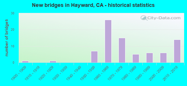
- New bridges - historical statistics
- 11900-1909
- 11920-1929
- 71950-1959
- 261960-1969
- 151970-1979
- 51980-1989
- 61990-1999
- 62000-2009
- 142010-2019

- Reconstructed bridges - Historical Statistics
- 11950-1959
- 01960-1969
- 11970-1979
- 21980-1989
- 01990-1999
- 12000-2009
- 12010-2019


- Bridge Condition - Deck
- 44.4%Good
- 3.7%Satisfactory
- 44.4%Fair
- 7.4%Poor

- Bridge Condition - Superstructure
- 81.5%Good
- 18.5%Fair

- Bridge Condition - Substructure
- 92.6%Good
- 7.4%Fair

- Bridge Condition - Channel
- 8.3%Excellent
- 41.7%Very good
- 33.3%Good
- 16.7%Satisfactory

- Bridge Condition - Culverts
- 50.0%Good
- 50.0%Satisfactory
Find on map >> Show street view
Structure Number: 33 0092, Location: 04-ALA-092-R4.91-HAY (Lat: 37.630553, Lng: -122.113492), Route carried "on" structure: State highway 92, Year Built: 1966, Year Reconstructed: 2014, Status: Open, Structure Length: 6.16m (20.21ft), Average Daily Traffic: 92,000 (year 2009), Average Future Daily Traffic: 143,493 (year 2043), Design Load: HS 20, Features Intersected: UP RR
Minimum Vertical Clearance: 30+ m (98+ ft), Kilometerpoint: 4.910, Lanes on structure: 10, Base Highway Network: Yes (, Subroute: 1), Owner: State Highway Agency, Approaching Roadway Width: 52.0m (170.6ft), Skew: 31 degrees, Material/Design: Concrete continuous, Design/Construction: Box Beam or Girders - Multiple, Number Of Spans In Main Unit: 3, Length of Maximum Span: 33.5m (109.9ft), Curb-To-Curb Width: 50.2m (164.7ft), Out-to-Out Width: 52.2m (171.3ft)
Condition: Deck: Good, Superstructure: Good, Substructure: Good, Operating Rating: 54.1 metric tons, Method Used To Determine Operating Rating: Field evaluation and documented engineering judgment, Inventory Rating: 32.4 metric tons, Method Used To Determine Inventory Rating: Field evaluation and documented engineering judgment, Structural Evaluation: Better than present minimum criteria, Deck Geometry: Superior to present desirable criteria, Underclear: Superior to present desirable criteria, Approach Roadway Alignment: Equal to present minimum criteria, Designated Inspection Frequency: Every 24 months, Inspection Date: September 2021, Deck Structure Type: Concrete Cast-file-Place
Find on map >> Show street view
Structure Number: 33 017, Location: 04-ALA-880-20.16 (Lat: 37.685275, Lng: -122.129694), Route carried "on" structure: Interstate 880, Year Built: 1991, Year Reconstructed: 2010, Status: Open, Structure Length: 4.79m (15.72ft), Average Daily Traffic: 222,000 (year 2016), Truck Traffic: 11%, Average Future Daily Traffic: 345,864 (year 2038), Design Load: HS 20+Mod, Features Intersected: HESPERIAN BLVD
Minimum Vertical Clearance: 30+ m (98+ ft), Kilometerpoint: 20.160, Lanes on structure: 12, Lanes under structure: 6, Base Highway Network: Yes (Inventory Route: 8, Subroute: 1), Owner: State Highway Agency, Approaching Roadway Width: 56.5m (185.4ft), Skew: 34 degrees, Material/Design: Prestressed concrete continuous, Design/Construction: Box Beam or Girders - Multiple, Number Of Spans In Main Unit: 2, Length of Maximum Span: 24.4m (80.1ft), Curb-To-Curb Width: 55.0m (180.4ft), Out-to-Out Width: 56.6m (185.7ft)
Condition: Deck: Fair, Superstructure: Fair, Substructure: Good, Operating Rating: 54.1 metric tons, Method Used To Determine Operating Rating: Assigned rating based on Load Factor Design (LFD) reported in metric tons, Inventory Rating: 32.4 metric tons, Method Used To Determine Inventory Rating: Assigned rating based on Load Factor Design (LFD) reported in metric tons, Structural Evaluation: Somewhat better than minimum adequacy, Deck Geometry: Superior to present desirable criteria, Underclear: Equal to present minimum criteria, Approach Roadway Alignment: Equal to present desirable criteria, Designated Inspection Frequency: Every 24 months, Inspection Date: May 2020, Deck Structure Type: Concrete Cast-file-Place
Find on map >> Show street view
Structure Number: 33 0179, Location: 04-ALA-880-18.35-HAY (Lat: 37.666131, Lng: -122.107186), Route carried "on" structure: Interstate 880, Year Built: 1952, Year Reconstructed: 1991, Status: Open, Structure Length: 4.62m (15.16ft), Average Daily Traffic: 250,000 (year 2016), Truck Traffic: 11%, Average Future Daily Traffic: 334,400 (year 2038), Design Load: HS 20, Features Intersected: A STREET
Minimum Vertical Clearance: 30+ m (98+ ft), Kilometerpoint: 18.350, Lanes on structure: 10, Lanes under structure: 5, Base Highway Network: Yes (Inventory Route: 8, Subroute: 1), Owner: State Highway Agency, Approaching Roadway Width: 48.9m (160.4ft), Skew: 32 degrees, Material/Design: Concrete continuous, Design/Construction: Tee Beam, Number Of Spans In Main Unit: 3, Length of Maximum Span: 22.6m (74.1ft), Curb-To-Curb Width: 48.9m (160.4ft), Out-to-Out Width: 50.5m (165.7ft)
Condition: Deck: Fair, Superstructure: Good, Substructure: Good, Operating Rating: 36.6 metric tons, Method Used To Determine Operating Rating: Load and Resistance Factor Rating (LRFR) rating reported by rating factor(RF) method using HL-93 loadings, Inventory Rating: 28.2 metric tons, Method Used To Determine Inventory Rating: Load and Resistance Factor Rating (LRFR) rating reported by rating factor(RF) method using HL-93 loadings, Structural Evaluation: Better than present minimum criteria, Deck Geometry: Superior to present desirable criteria, Underclear: High priority of corrective action, Approach Roadway Alignment: Equal to present desirable criteria, Designated Inspection Frequency: Every 24 months, Inspection Date: May 2020, Deck Structure Type: Concrete Cast-file-Place, Wearing Surface/Protective System: Wearing Surface: Bituminous
Find on map >> Show street view
Structure Number: 33 0181, Location: 04-ALA-880-17.60-HAY (Lat: 37.656158, Lng: -122.101856), Route carried "on" structure: City street , Year Built: 1968, Status: Open, Structure Length: 8.44m (27.69ft), Average Daily Traffic: 52,800 (year 2016), Truck Traffic: 2%, Average Future Daily Traffic: 94,292 (year 2038), Design Load: HS 20, Features Intersected: INTERSTATE 880, Facility Carried by Structure: WINTON AVE
Minimum Vertical Clearance: 30+ m (98+ ft), Kilometerpoint: 0.000, Lanes on structure: 6, Lanes under structure: 12, Owner: State Highway Agency, Approaching Roadway Width: 23.2m (76.1ft), Skew: 20 degrees, Material/Design: Prestressed concrete continuous, Design/Construction: Box Beam or Girders - Multiple, Number Of Spans In Main Unit: 3, Length of Maximum Span: 43.0m (141.1ft), Curb or Sidewalk Widths: Left: 1.5m (4.9ft), Right: 1.5m (4.9ft), Curb-To-Curb Width: 23.2m (76.1ft), Out-to-Out Width: 28.6m (93.8ft)
Condition: Deck: Poor, Superstructure: Good, Substructure: Good, Operating Rating: 56.7 metric tons, Method Used To Determine Operating Rating: Load and Resistance Factor Rating (LRFR) rating reported by rating factor(RF) method using HL-93 loadings, Inventory Rating: 36.0 metric tons, Method Used To Determine Inventory Rating: Load and Resistance Factor Rating (LRFR) rating reported by rating factor(RF) method using HL-93 loadings, Structural Evaluation: Better than present minimum criteria, Deck Geometry: Meets minimum limits, Underclear: High priority of corrective action, Approach Roadway Alignment: Equal to present desirable criteria, Designated Inspection Frequency: Every 24 months, Inspection Date: May 2020, Deck Structure Type: Concrete Cast-file-Place
Find on map >> Show street view
Structure Number: 33 0236, Location: 04-ALA-880-15.65-HAY (Lat: 37.631456, Lng: -122.084806), Route carried "on" structure: City street , Year Built: 1958, Status: Open, Structure Length: 8.84m (29.00ft), Average Daily Traffic: 41,900 (year 2016), Truck Traffic: 3%, Average Future Daily Traffic: 62,862 (year 2038), Design Load: HS 20, Features Intersected: INTERSTATE 880, Facility Carried by Structure: TENNYSON ROAD
Minimum Vertical Clearance: 30+ m (98+ ft), Kilometerpoint: 0.000, Lanes on structure: 4, Lanes under structure: 10, Owner: State Highway Agency, Approaching Roadway Width: 14.6m (47.9ft), Skew: 22 degrees, Material/Design: Concrete continuous, Design/Construction: Tee Beam, Number Of Spans In Main Unit: 4, Length of Maximum Span: 29.0m (95.1ft), Curb or Sidewalk Widths: Left: 1.5m (4.9ft), Right: 1.5m (4.9ft), Curb-To-Curb Width: 14.6m (47.9ft), Out-to-Out Width: 19.0m (62.3ft)
Condition: Deck: Fair, Superstructure: Good, Substructure: Good, Operating Rating: 71.6 metric tons, Method Used To Determine Operating Rating: Load Factor (LF), Inventory Rating: 43.1 metric tons, Method Used To Determine Inventory Rating: Load Factor (LF), Structural Evaluation: Better than present minimum criteria, Deck Geometry: High priority of replacement, Underclear: High priority of corrective action, Approach Roadway Alignment: Equal to present desirable criteria, Designated Inspection Frequency: Every 24 months, Inspection Date: May 2020, Deck Structure Type: Concrete Cast-file-Place
Find on map >> Show street view
Structure Number: 33 0245, Location: 04-ALA-880-13.67-HAY (Lat: 37.606692, Lng: -122.066322), Route carried "on" structure: Interstate 880, Year Built: 1956, Year Reconstructed: 1993, Status: Open, Structure Length: 4.51m (14.80ft), Average Daily Traffic: 230,000 (year 2019), Truck Traffic: 11%, Average Future Daily Traffic: 277,581 (year 2041), Design Load: HS 20+Mod, Features Intersected: WHIPPLE ROAD
Minimum Vertical Clearance: 30+ m (98+ ft), Kilometerpoint: 13.670, Lanes on structure: 9, Lanes under structure: 5, Base Highway Network: Yes (Inventory Route: 8, Subroute: 1), Owner: State Highway Agency, Approaching Roadway Width: 48.8m (160.1ft), Skew: 30 degrees, Material/Design: Concrete continuous, Design/Construction: Tee Beam, Number Of Spans In Main Unit: 3, Length of Maximum Span: 21.9m (71.9ft), Curb-To-Curb Width: 48.8m (160.1ft), Out-to-Out Width: 50.4m (165.4ft)
Condition: Deck: Fair, Superstructure: Good, Substructure: Good, Operating Rating: 25.6 metric tons, Method Used To Determine Operating Rating: Load and Resistance Factor Rating (LRFR) rating reported by rating factor(RF) method using HL-93 loadings, Inventory Rating: 19.8 metric tons, Method Used To Determine Inventory Rating: Load and Resistance Factor Rating (LRFR) rating reported by rating factor(RF) method using HL-93 loadings, Structural Evaluation: Somewhat better than minimum adequacy, Deck Geometry: Superior to present desirable criteria, Underclear: High priority of corrective action, Approach Roadway Alignment: Equal to present desirable criteria, Designated Inspection Frequency: Every 24 months, Inspection Date: April 2021, Deck Structure Type: Concrete Cast-file-Place, Wearing Surface/Protective System: Wearing Surface: Epoxy Overlay
Find on map >> Show street view
Structure Number: 33 0245K, Location: 04-ALA-880-13.67-HAY (Lat: 37.606511, Lng: -122.066889), Route carried "on" structure: Ramp Interstate 880, Year Built: 1993, Status: Open, Structure Length: 4.48m (14.70ft), Average Daily Traffic: 13,200 (year 2019), Truck Traffic: 5%, Average Future Daily Traffic: 15,980 (year 2041), Design Load: HS 20+Mod, Features Intersected: WHIPPLE ROAD
Minimum Vertical Clearance: 30+ m (98+ ft), Kilometerpoint: 13.670, Lanes on structure: 1, Lanes under structure: 5, Base Highway Network: Yes (Inventory Route: 8, Subroute: 1), Owner: State Highway Agency, Approaching Roadway Width: 7.3m (24.0ft), Material/Design: Prestressed concrete, Design/Construction: Stringer/Multi-beam, Number Of Spans In Main Unit: 1, Number Of Approach Spans: 2, Length of Maximum Span: 21.9m (71.9ft), Curb-To-Curb Width: 7.3m (24.0ft), Out-to-Out Width: 8.4m (27.6ft)
Condition: Deck: Good, Superstructure: Good, Substructure: Good, Operating Rating: 54.1 metric tons, Method Used To Determine Operating Rating: Assigned rating based on Load Factor Design (LFD) reported in metric tons, Inventory Rating: 32.4 metric tons, Method Used To Determine Inventory Rating: Assigned rating based on Load Factor Design (LFD) reported in metric tons, Structural Evaluation: Better than present minimum criteria, Deck Geometry: Better than present minimum criteria, Underclear: High priority of corrective action, Approach Roadway Alignment: Equal to present desirable criteria, Designated Inspection Frequency: Every 24 months, Inspection Date: April 2021, Deck Structure Type: Concrete Cast-file-Place
Find on map >> Show street view
Structure Number: 33 0245S, Location: 04-ALA-880-13.67-HAY (Lat: 37.606725, Lng: -122.066194), Route carried "on" structure: Ramp Interstate 880, Year Built: 1993, Status: Open, Structure Length: 4.45m (14.60ft), Average Daily Traffic: 12,000 (year 2013), Truck Traffic: 5%, Average Future Daily Traffic: 15,980 (year 2041), Design Load: HS 20+Mod, Features Intersected: WHIPPLE ROAD
Minimum Vertical Clearance: 30+ m (98+ ft), Kilometerpoint: 13.670, Lanes on structure: 1, Lanes under structure: 5, Base Highway Network: Yes (Inventory Route: 8, Subroute: 1), Owner: State Highway Agency, Approaching Roadway Width: 7.3m (24.0ft), Material/Design: Prestressed concrete, Design/Construction: Stringer/Multi-beam, Number Of Spans In Main Unit: 1, Number Of Approach Spans: 2, Length of Maximum Span: 21.9m (71.9ft), Curb-To-Curb Width: 7.3m (24.0ft), Out-to-Out Width: 8.4m (27.6ft)
Condition: Deck: Good, Superstructure: Good, Substructure: Fair, Operating Rating: 54.1 metric tons, Method Used To Determine Operating Rating: Assigned rating based on Load Factor Design (LFD) reported in metric tons, Inventory Rating: 32.4 metric tons, Method Used To Determine Inventory Rating: Assigned rating based on Load Factor Design (LFD) reported in metric tons, Structural Evaluation: Somewhat better than minimum adequacy, Deck Geometry: Better than present minimum criteria, Underclear: High priority of corrective action, Approach Roadway Alignment: Equal to present desirable criteria, Designated Inspection Frequency: Every 24 months, Inspection Date: April 2021, Deck Structure Type: Concrete Cast-file-Place
Find on map >> Show street view
Structure Number: 33 0372, Location: 04-ALA-092-R4.48-HAY (Lat: 37.628686, Lng: -122.120819), Route carried "on" structure: City street , Year Built: 1966, Status: Open, Structure Length: 10.85m (35.60ft), Average Daily Traffic: 17,550 (year 2009), Truck Traffic: 4%, Average Future Daily Traffic: 21,448 (year 2043), Design Load: HS 20, Features Intersected: STATE ROUTE 92, Facility Carried by Structure: CLAWITER ROAD
Minimum Vertical Clearance: 30+ m (98+ ft), Kilometerpoint: 0.000, Lanes on structure: 2, Lanes under structure: 8, Owner: State Highway Agency, Approaching Roadway Width: 8.5m (27.9ft), Skew: 4 degrees, Material/Design: Prestressed concrete continuous, Design/Construction: Stringer/Multi-beam, Number Of Spans In Main Unit: 4, Length of Maximum Span: 32.3m (106.0ft), Curb or Sidewalk Widths: Left: 1.5m (4.9ft), Right: 0.6m (2.0ft), Curb-To-Curb Width: 8.5m (27.9ft), Out-to-Out Width: 11.3m (37.1ft)
Condition: Deck: Good, Superstructure: Good, Substructure: Good, Operating Rating: 51.2 metric tons, Method Used To Determine Operating Rating: Load and Resistance Factor Rating (LRFR) rating reported by rating factor(RF) method using HL-93 loadings, Inventory Rating: 33.4 metric tons, Method Used To Determine Inventory Rating: Load and Resistance Factor Rating (LRFR) rating reported by rating factor(RF) method using HL-93 loadings, Structural Evaluation: Better than present minimum criteria, Deck Geometry: Meets minimum limits, Underclear: Meets minimum limits, Approach Roadway Alignment: Equal to present minimum criteria, Designated Inspection Frequency: Every 24 months, Inspection Date: September 2021, Deck Structure Type: Concrete Cast-file-Place
Find on map >> Show street view
Structure Number: 33 039, Location: 04-ALA-580-11.53 (Lat: 37.702519, Lng: -121.755564), Route carried "on" structure: County highway , Year Built: 1972, Status: Open, Structure Length: 7.04m (23.10ft), Average Daily Traffic: 1,000 (year 2016), Truck Traffic: 5%, Average Future Daily Traffic: 1,095 (year 2042), Design Load: HS 20, Features Intersected: INTERSTATE 580, Facility Carried by Structure: LAS COLINAS RD
Minimum Vertical Clearance: 5.38m (17.65ft), Kilometerpoint: 0.000, Lanes on structure: 2, Lanes under structure: 13, Owner: State Highway Agency, Approaching Roadway Width: 12.2m (40.0ft), Material/Design: Prestressed concrete continuous, Design/Construction: Box Beam or Girders - Multiple, Number Of Spans In Main Unit: 2, Length of Maximum Span: 35.7m (117.1ft), Curb or Sidewalk Widths: Left: 1.5m (4.9ft), Right: 0.0m, Curb-To-Curb Width: 12.2m (40.0ft), Out-to-Out Width: 14.3m (46.9ft)
Condition: Deck: Fair, Superstructure: Good, Substructure: Good, Operating Rating: 47.0 metric tons, Method Used To Determine Operating Rating: Load and Resistance Factor Rating (LRFR) rating reported by rating factor(RF) method using HL-93 loadings, Inventory Rating: 32.4 metric tons, Method Used To Determine Inventory Rating: Load and Resistance Factor Rating (LRFR) rating reported by rating factor(RF) method using HL-93 loadings, Structural Evaluation: Better than present minimum criteria, Deck Geometry: Equal to present desirable criteria, Underclear: Meets minimum limits, Approach Roadway Alignment: Somewhat better than minimum adequacy, Designated Inspection Frequency: Every 24 months, Inspection Date: January 2022, Deck Structure Type: Concrete Cast-file-Place
Find on map >> Show street view
Structure Number: 33 0398, Location: 04-ALA-880-14.54-HAY (Lat: 37.617461, Lng: -122.074786), Route carried "on" structure: City street , Year Built: 1968, Status: Open, Structure Length: 11.89m (39.01ft), Average Daily Traffic: 36,000 (year 2016), Truck Traffic: 5%, Average Future Daily Traffic: 62,862 (year 2038), Design Load: HS 20, Features Intersected: INTERSTATE 880, WARD CRK, Facility Carried by Structure: INDUSTRIAL PARKWAY
Minimum Vertical Clearance: 30+ m (98+ ft), Kilometerpoint: 0.000, Lanes on structure: 4, Lanes under structure: 8, Owner: State Highway Agency, Approaching Roadway Width: 17.7m (58.1ft), Skew: 23 degrees, Material/Design: Prestressed concrete continuous, Design/Construction: Stringer/Multi-beam, Number Of Spans In Main Unit: 5, Length of Maximum Span: 25.6m (84.0ft), Curb or Sidewalk Widths: Left: 1.5m (4.9ft), Right: 1.5m (4.9ft), Curb-To-Curb Width: 15.8m (51.8ft), Out-to-Out Width: 21.2m (69.6ft)
Condition: Deck: Fair, Superstructure: Fair, Substructure: Fair, Channel: Very good, Operating Rating: 85.5 metric tons, Method Used To Determine Operating Rating: Load Factor (LF), Inventory Rating: 32.4 metric tons, Method Used To Determine Inventory Rating: Load Factor (LF), Structural Evaluation: Somewhat better than minimum adequacy, Deck Geometry: Meets minimum limits, Underclear: Meets minimum limits, Waterway Adequacy: Equal to present desirable criteria, Approach Roadway Alignment: Equal to present desirable criteria, Designated Inspection Frequency: Every 24 months, Inspection Date: May 2020, Deck Structure Type: Concrete Cast-file-Place
Find on map >> Show street view
Structure Number: 33 0399S, Location: 04-ALA-880-14.56-HAY (Lat: 37.618003, Lng: -122.073706), Route carried "on" structure: Ramp State highway 880, Year Built: 1968, Status: Open, Structure Length: 3.11m (10.20ft), Average Daily Traffic: 6,100 (year 2016), Truck Traffic: 11%, Average Future Daily Traffic: 20,954 (year 2038), Design Load: HS 20, Features Intersected: WARD CREEK
Minimum Vertical Clearance: 30+ m (98+ ft), Kilometerpoint: 14.560, Lanes on structure: 2, Base Highway Network: Yes (Inventory Route: 8, Subroute: 1), Owner: State Highway Agency, Approaching Roadway Width: 10.6m (34.8ft), Skew: 1 degrees, Material/Design: Concrete continuous, Design/Construction: Slab, Number Of Spans In Main Unit: 4, Length of Maximum Span: 8.5m (27.9ft), Curb-To-Curb Width: 10.6m (34.8ft), Out-to-Out Width: 11.2m (36.7ft)
Condition: Deck: Fair, Superstructure: Fair, Substructure: Good, Channel: Excellent, Operating Rating: 57.0 metric tons, Method Used To Determine Operating Rating: Load Factor (LF), Inventory Rating: 34.3 metric tons, Method Used To Determine Inventory Rating: Load Factor (LF), Structural Evaluation: Somewhat better than minimum adequacy, Deck Geometry: Better than present minimum criteria, Waterway Adequacy: Equal to present desirable criteria, Approach Roadway Alignment: Equal to present desirable criteria, Designated Inspection Frequency: Every 24 months, Inspection Date: May 2020, Deck Structure Type: Concrete Cast-file-Place
Find on map >> Show street view
Structure Number: 33 044, Location: 04-ALA-980-1.11-OAK (Lat: 37.811733, Lng: -122.273900), Route carried "on" structure: Interstate 980, Year Built: 1973, Year Reconstructed: 1981, Status: Open, Structure Length: 29.26m (96.00ft), Average Daily Traffic: 115,000 (year 2012), Truck Traffic: 3%, Average Future Daily Traffic: 118,300 (year 2037), Design Load: HS 20, Features Intersected: SAN PABLO, W GRAND, MLKJ
Minimum Vertical Clearance: 30+ m (98+ ft), Kilometerpoint: 1.110, Lanes on structure: 10, Lanes under structure: 16, Base Highway Network: Yes (Inventory Route: 9, Subroute: 1), Owner: State Highway Agency, Approaching Roadway Width: 50.6m (166.0ft), Skew: 29 degrees, Material/Design: Prestressed concrete continuous, Design/Construction: Box Beam or Girders - Multiple, Number Of Spans In Main Unit: 2, Number Of Approach Spans: 6, Length of Maximum Span: 58.8m (192.9ft), Curb-To-Curb Width: 50.4m (165.4ft), Out-to-Out Width: 51.6m (169.3ft)
Condition: Deck: Good, Superstructure: Good, Substructure: Good, Operating Rating: 84.9 metric tons, Method Used To Determine Operating Rating: Load Factor (LF), Inventory Rating: 32.4 metric tons, Method Used To Determine Inventory Rating: Load Factor (LF), Structural Evaluation: Better than present minimum criteria, Deck Geometry: Superior to present desirable criteria, Underclear: Somewhat better than minimum adequacy, Approach Roadway Alignment: Better than present minimum criteria, Length Of Structure Improvement: 29.26m (96.00ft), Designated Inspection Frequency: Every 24 months, Inspection Date: May 2020, Deck Structure Type: Concrete Cast-file-Place
Find on map >> Show street view
Structure Number: 33 0445, Location: 04-ALA-092-R5.76-HAY (Lat: 37.636489, Lng: -122.100292), Route carried "on" structure: City street , Year Built: 1975, Status: Open, Structure Length: 6.25m (20.51ft), Average Daily Traffic: 36,700 (year 2010), Truck Traffic: 4%, Average Future Daily Traffic: 41,823 (year 2043), Design Load: HS 20, Features Intersected: STATE ROUTE 92 & RAMPS, Facility Carried by Structure: HESPERIAN BLVD
Minimum Vertical Clearance: 30+ m (98+ ft), Kilometerpoint: 0.000, Lanes on structure: 6, Lanes under structure: 9, Owner: State Highway Agency, Approaching Roadway Width: 27.4m (89.9ft), Skew: 30 degrees, Material/Design: Concrete continuous, Design/Construction: Box Beam or Girders - Multiple, Number Of Spans In Main Unit: 2, Length of Maximum Span: 34.7m (113.8ft), Curb or Sidewalk Widths: Left: 1.5m (4.9ft), Right: 1.5m (4.9ft), Curb-To-Curb Width: 25.5m (83.7ft), Out-to-Out Width: 31.1m (102.0ft)
Condition: Deck: Fair, Superstructure: Fair, Substructure: Good, Operating Rating: 57.3 metric tons, Method Used To Determine Operating Rating: Load and Resistance Factor Rating (LRFR) rating reported by rating factor(RF) method using HL-93 loadings, Inventory Rating: 44.1 metric tons, Method Used To Determine Inventory Rating: Load and Resistance Factor Rating (LRFR) rating reported by rating factor(RF) method using HL-93 loadings, Structural Evaluation: Somewhat better than minimum adequacy, Deck Geometry: Somewhat better than minimum adequacy, Underclear: Meets minimum limits, Approach Roadway Alignment: Somewhat better than minimum adequacy, Designated Inspection Frequency: Every 24 months, Inspection Date: September 2021, Deck Structure Type: Concrete Cast-file-Place
Find on map >> Show street view
Structure Number: 33 0673, Location: 04-ALA-580-R9.40-LVMR (Lat: 37.711772, Lng: -121.716611), Route carried "on" structure: Interstate 580, Year Built: 1969, Status: Open, Structure Length: 0.78m (2.56ft), Average Daily Traffic: 175,000 (year 2020), Truck Traffic: 8%, Average Future Daily Traffic: 255,483 (year 2039), Features Intersected: ALTAMONT CREEK TRIBUTARY
Minimum Vertical Clearance: 30+ m (98+ ft), Kilometerpoint: 9.400, Lanes on structure: 12, Base Highway Network: Yes (Inventory Route: 5, Subroute: 1), Owner: State Highway Agency, Approaching Roadway Width: 87.8m (288.1ft), Skew: 30 degrees, Material/Design: Concrete continuous, Design/Construction: Culvert, Number Of Spans In Main Unit: 2, Length of Maximum Span: 3.7m (12.1ft), Curb or Sidewalk Widths: Left: 1.2m (3.9ft), Right: 3.1m (10.2ft), Curb-To-Curb Width: 87.8m (288.1ft), Out-to-Out Width: 107.3m (352.0ft)
Condition: Channel: Satisfactory, Culverts: Good, Operating Rating: 54.1 metric tons, Method Used To Determine Operating Rating: Field evaluation and documented engineering judgment, Inventory Rating: 32.4 metric tons, Method Used To Determine Inventory Rating: Field evaluation and documented engineering judgment, Structural Evaluation: Better than present minimum criteria, Deck Geometry: Superior to present desirable criteria, Waterway Adequacy: Equal to present desirable criteria, Approach Roadway Alignment: Equal to present desirable criteria, Designated Inspection Frequency: Every 24 months, Inspection Date: January 2022
Find on map >> Show street view
Structure Number: 33 0676G, Location: 04-ALA-880-16.79-HAY (Lat: 37.646014, Lng: -122.094206), Route carried "on" structure: Ramp State highway 880, Year Built: 2011, Status: Open, Structure Length: 5.98m (19.62ft), Average Daily Traffic: 22,500 (year 2016), Truck Traffic: 10%, Average Future Daily Traffic: 30,605 (year 2038), Design Load: HS 20+Mod, Features Intersected: E 92-N 880 CONNECTOR
Minimum Vertical Clearance: 30+ m (98+ ft), Kilometerpoint: 16.790, Lanes on structure: 1, Lanes under structure: 3, Owner: State Highway Agency, Approaching Roadway Width: 10.7m (35.1ft), Skew: 9 degrees, Material/Design: Concrete continuous, Design/Construction: Box Beam or Girders - Multiple, Number Of Spans In Main Unit: 3, Length of Maximum Span: 28.1m (92.2ft), Curb-To-Curb Width: 9.7m (31.8ft), Out-to-Out Width: 10.7m (35.1ft)
Condition: Deck: Poor, Superstructure: Good, Substructure: Good, Operating Rating: 54.1 metric tons, Method Used To Determine Operating Rating: Assigned rating based on Load Factor Design (LFD) reported in metric tons, Inventory Rating: 32.4 metric tons, Method Used To Determine Inventory Rating: Assigned rating based on Load Factor Design (LFD) reported in metric tons, Structural Evaluation: Better than present minimum criteria, Deck Geometry: Superior to present desirable criteria, Underclear: Superior to present desirable criteria, Approach Roadway Alignment: Equal to present desirable criteria, Designated Inspection Frequency: Every 24 months, Inspection Date: May 2020, Deck Structure Type: Concrete Cast-file-Place
Find on map >> Show street view
Structure Number: 33 0677, Location: 04-ALA-092-6.35-HAY (Lat: 37.643969, Lng: -122.094058), Route carried "on" structure: State highway 92, Year Built: 2011, Status: Open, Structure Length: 18.38m (60.30ft), Average Daily Traffic: 111,000 (year 2009), Truck Traffic: 7%, Average Future Daily Traffic: 134,943 (year 2043), Design Load: HS 20+Mod, Features Intersected: I 880, E92-N880,S880-E92
Minimum Vertical Clearance: 30+ m (98+ ft), Kilometerpoint: 6.350, Lanes on structure: 6, Lanes under structure: 15, Base Highway Network: Yes (, Subroute: 1), Owner: State Highway Agency, Approaching Roadway Width: 34.0m (111.5ft), Skew: 33 degrees, Material/Design: Prestressed concrete continuous, Design/Construction: Box Beam or Girders - Multiple, Number Of Spans In Main Unit: 6, Length of Maximum Span: 41.9m (137.5ft), Curb-To-Curb Width: 33.0m (108.3ft), Out-to-Out Width: 33.7m (110.6ft)
Condition: Deck: Good, Superstructure: Good, Substructure: Good, Operating Rating: 54.1 metric tons, Method Used To Determine Operating Rating: Assigned rating based on Load Factor Design (LFD) reported in metric tons, Inventory Rating: 32.4 metric tons, Method Used To Determine Inventory Rating: Assigned rating based on Load Factor Design (LFD) reported in metric tons, Structural Evaluation: Better than present minimum criteria, Deck Geometry: Superior to present desirable criteria, Underclear: Somewhat better than minimum adequacy, Approach Roadway Alignment: Equal to present desirable criteria, Designated Inspection Frequency: Every 24 months, Inspection Date: September 2021, Deck Structure Type: Concrete Cast-file-Place
Find on map >> Show street view
Structure Number: 33 0678F, Location: 04-ALA-092-6.37-HAY (Lat: 37.645464, Lng: -122.094681), Route carried "on" structure: Ramp State highway 92, Year Built: 2010, Status: Open, Structure Length: 12.93m (42.42ft), Average Daily Traffic: 40,000 (year 2011), Truck Traffic: 7%, Average Future Daily Traffic: 63,703 (year 2043), Design Load: HS 20+Mod, Features Intersected: I 880, E92-N880 CONNECTR
Minimum Vertical Clearance: 30+ m (98+ ft), Kilometerpoint: 6.370, Lanes on structure: 1, Lanes under structure: 11, Owner: State Highway Agency, Approaching Roadway Width: 8.2m (26.9ft), Skew: 4 degrees, Material/Design: Concrete continuous, Design/Construction: Box Beam or Girders - Multiple, Number Of Spans In Main Unit: 4, Length of Maximum Span: 36.1m (118.4ft), Curb-To-Curb Width: 7.2m (23.6ft), Out-to-Out Width: 8.2m (26.9ft)
Condition: Deck: Good, Superstructure: Good, Substructure: Good, Operating Rating: 54.1 metric tons, Method Used To Determine Operating Rating: Assigned rating based on Load Factor Design (LFD) reported in metric tons, Inventory Rating: 32.4 metric tons, Method Used To Determine Inventory Rating: Assigned rating based on Load Factor Design (LFD) reported in metric tons, Structural Evaluation: Better than present minimum criteria, Deck Geometry: Equal to present minimum criteria, Underclear: Equal to present minimum criteria, Approach Roadway Alignment: Equal to present desirable criteria, Designated Inspection Frequency: Every 24 months, Inspection Date: September 2021, Deck Structure Type: Concrete Cast-file-Place
Find on map >> Show street view
Structure Number: 33 0679G, Location: 04-ALA-092-6.27-HAY (Lat: 37.642650, Lng: -122.094167), Route carried "on" structure: Ramp State highway 92, Year Built: 2009, Status: Open, Structure Length: 24.80m (81.36ft), Average Daily Traffic: 106,000 (year 2009), Truck Traffic: 7%, Average Future Daily Traffic: 161,932 (year 2043), Design Load: HS 20, Features Intersected: I 880, S880-E92 CONNECTR
Minimum Vertical Clearance: 30+ m (98+ ft), Kilometerpoint: 6.270, Lanes on structure: 3, Lanes under structure: 10, Owner: State Highway Agency, Approaching Roadway Width: 17.7m (58.1ft), Skew: 9 degrees, Material/Design: Prestressed concrete continuous, Design/Construction: Box Beam or Girders - Multiple, Number Of Spans In Main Unit: 7, Length of Maximum Span: 47.0m (154.2ft), Curb-To-Curb Width: 17.7m (58.1ft), Out-to-Out Width: 27.8m (91.2ft)
Condition: Deck: Good, Superstructure: Good, Substructure: Good, Operating Rating: 54.1 metric tons, Method Used To Determine Operating Rating: Assigned rating based on Load Factor Design (LFD) reported in metric tons, Inventory Rating: 32.4 metric tons, Method Used To Determine Inventory Rating: Assigned rating based on Load Factor Design (LFD) reported in metric tons, Structural Evaluation: Better than present minimum criteria, Deck Geometry: Superior to present desirable criteria, Underclear: Equal to present minimum criteria, Approach Roadway Alignment: Equal to present minimum criteria, Designated Inspection Frequency: Every 24 months, Inspection Date: September 2021, Deck Structure Type: Concrete Cast-file-Place
Find on map >> Show street view
Structure Number: 33C0071, Location: BTWN 4TH & RUBY ST (Lat: 37.678742, Lng: -122.076819), Route carried "on" structure: City street , Year Built: 1960, Status: Open, Structure Length: 2.83m (9.28ft), Average Daily Traffic: 30,600 (year 2006), Truck Traffic: 2%, Average Future Daily Traffic: 32,821 (year 2042), Design Load: HS 20, Features Intersected: SAN LORENZO CREEK, Facility Carried by Structure: A ST
Minimum Vertical Clearance: 30+ m (98+ ft), Kilometerpoint: 0.000, Lanes on structure: 5, Base Highway Network: Yes, Owner: City or Municipal Highway Agency, Approaching Roadway Width: 21.9m (71.9ft), Material/Design: Steel, Design/Construction: Stringer/Multi-beam, Number Of Spans In Main Unit: 1, Length of Maximum Span: 28.3m (92.8ft), Curb or Sidewalk Widths: Left: 1.8m (5.9ft), Right: 1.8m (5.9ft), Curb-To-Curb Width: 21.9m (71.9ft), Out-to-Out Width: 26.3m (86.3ft)
Condition: Deck: Satisfactory, Superstructure: Good, Substructure: Good, Channel: Satisfactory, Operating Rating: 89.7 metric tons, Method Used To Determine Operating Rating: Load Factor (LF), Inventory Rating: 53.8 metric tons, Method Used To Determine Inventory Rating: Load Factor (LF), Structural Evaluation: Better than present minimum criteria, Deck Geometry: Somewhat better than minimum adequacy, Waterway Adequacy: Equal to present desirable criteria, Approach Roadway Alignment: Equal to present minimum criteria, Designated Inspection Frequency: Every 48 months, Inspection Date: October 2020, Deck Structure Type: Concrete Cast-file-Place
Find on map >> Show street view
Structure Number: 33C0114, Location: 0.3 MI S/W INDUSTRL PKWY (Lat: 37.614278, Lng: -122.065764), Route carried "on" structure: City street , Year Built: 1989, Status: Open, Structure Length: 4.28m (14.04ft), Average Daily Traffic: 26,257 (year 2010), Truck Traffic: 15%, Average Future Daily Traffic: 27,131 (year 2040), Features Intersected: ALAMEDA CREEK BRANCH, Facility Carried by Structure: INDUSTRIAL PKWY W
Minimum Vertical Clearance: 30+ m (98+ ft), Kilometerpoint: 0.000, Lanes on structure: 4, Owner: City or Municipal Highway Agency, Approaching Roadway Width: 23.8m (78.1ft), Material/Design: Concrete continuous, Design/Construction: Slab, Number Of Spans In Main Unit: 4, Length of Maximum Span: 10.7m (35.1ft), Curb or Sidewalk Widths: Left: 1.8m (5.9ft), Right: 0.0m, Curb-To-Curb Width: 22.0m (72.2ft), Out-to-Out Width: 24.7m (81.0ft)
Condition: Deck: Good, Superstructure: Good, Substructure: Good, Channel: Good, Operating Rating: 54.1 metric tons, Method Used To Determine Operating Rating: Field evaluation and documented engineering judgment, Inventory Rating: 32.4 metric tons, Method Used To Determine Inventory Rating: Field evaluation and documented engineering judgment, Structural Evaluation: Better than present minimum criteria, Deck Geometry: Superior to present desirable criteria, Waterway Adequacy: Superior to present desirable criteria, Approach Roadway Alignment: Equal to present desirable criteria, Designated Inspection Frequency: Every 24 months, Inspection Date: October 2020, Deck Structure Type: Concrete Cast-file-Place
Find on map >> Show street view
Structure Number: 33C0169, Location: 0.15 MI E/O TAMPA AVE (Lat: 37.631236, Lng: -122.073136), Route carried "on" structure: City street , Year Built: 1973, Status: Open, Structure Length: 0.82m (2.69ft), Average Daily Traffic: 34,200 (year 2007), Truck Traffic: 2%, Average Future Daily Traffic: 78,769 (year 2042), Features Intersected: WARD CREEK, Facility Carried by Structure: TENNYSON ROAD
Minimum Vertical Clearance: 30+ m (98+ ft), Kilometerpoint: 0.000, Lanes on structure: 4, Base Highway Network: Yes, Owner: City or Municipal Highway Agency, Approaching Roadway Width: 27.4m (89.9ft), Skew: 23 degrees, Material/Design: Concrete continuous, Design/Construction: Culvert, Number Of Spans In Main Unit: 2, Length of Maximum Span: 4.0m (13.1ft), Curb or Sidewalk Widths: Left: 2.8m (9.2ft), Right: 3.0m (9.8ft), Curb-To-Curb Width: 22.0m (72.2ft), Out-to-Out Width: 33.5m (109.9ft)
Condition: Channel: Very good, Culverts: Satisfactory, Operating Rating: 54.1 metric tons, Method Used To Determine Operating Rating: Field evaluation and documented engineering judgment, Inventory Rating: 32.4 metric tons, Method Used To Determine Inventory Rating: Field evaluation and documented engineering judgment, Structural Evaluation: Equal to present minimum criteria, Deck Geometry: Superior to present desirable criteria, Waterway Adequacy: Equal to present desirable criteria, Approach Roadway Alignment: Equal to present desirable criteria, Designated Inspection Frequency: Every 48 months, Inspection Date: October 2020, Deck Structure Type: Concrete Cast-file-Place, Wearing Surface/Protective System: Wearing Surface: Bituminous
Find on map >> Show street view
Structure Number: 33C021, Location: E OF THACKERAY AVE (Lat: 37.624461, Lng: -122.072008), Route carried "on" structure: City street , Year Built: 1960, Status: Open, Structure Length: 1.23m (4.04ft), Average Daily Traffic: 8,714 (year 2007), Truck Traffic: 2%, Average Future Daily Traffic: 9,129 (year 2040), Features Intersected: TENNYSON FLOOD CNTRL CHN, Facility Carried by Structure: FOLSOM AVE
Minimum Vertical Clearance: 30+ m (98+ ft), Kilometerpoint: 0.000, Lanes on structure: 2, Owner: City or Municipal Highway Agency, Approaching Roadway Width: 7.3m (24.0ft), Material/Design: Concrete continuous, Design/Construction: Culvert, Number Of Spans In Main Unit: 3, Length of Maximum Span: 4.1m (13.5ft), Curb or Sidewalk Widths: Left: 2.3m (7.5ft), Right: 2.8m (9.2ft), Curb-To-Curb Width: 12.8m (42.0ft), Out-to-Out Width: 18.3m (60.0ft)
Condition: Channel: Good, Culverts: Satisfactory, Operating Rating: 40.5 metric tons, Method Used To Determine Operating Rating: Field evaluation and documented engineering judgment, Inventory Rating: 24.3 metric tons, Method Used To Determine Inventory Rating: Field evaluation and documented engineering judgment, Structural Evaluation: Equal to present minimum criteria, Deck Geometry: Somewhat better than minimum adequacy, Waterway Adequacy: Equal to present desirable criteria, Approach Roadway Alignment: Equal to present desirable criteria, Designated Inspection Frequency: Every 24 months, Inspection Date: October 2020, Deck Structure Type: Concrete Cast-file-Place, Wearing Surface/Protective System: Wearing Surface: Bituminous
Find on map >> Show street view
Structure Number: 33C0211, Location: ORCHARD AVE (Lat: 37.658683, Lng: -122.076722), Route carried "on" structure: City street , Year Built: 1970, Status: Open, Structure Length: 5.11m (16.77ft), Average Daily Traffic: 8,226 (year 2010), Truck Traffic: 2%, Average Future Daily Traffic: 6,563 (year 2042), Design Load: HS 20, Features Intersected: ORCHARD AVE, Facility Carried by Structure: WHITMAN ST
Minimum Vertical Clearance: 30+ m (98+ ft), Kilometerpoint: 0.000, Lanes on structure: 2, Lanes under structure: 4, Owner: City or Municipal Highway Agency, Approaching Roadway Width: 12.1m (39.7ft), Material/Design: Concrete continuous, Design/Construction: Box Beam or Girders - Multiple, Number Of Spans In Main Unit: 4, Length of Maximum Span: 15.1m (49.5ft), Curb or Sidewalk Widths: Left: 1.8m (5.9ft), Right: 0.6m (2.0ft), Curb-To-Curb Width: 12.1m (39.7ft), Out-to-Out Width: 17.7m (58.1ft)
Condition: Deck: Fair, Superstructure: Good, Substructure: Good, Operating Rating: 45.4 metric tons, Method Used To Determine Operating Rating: Load and Resistance Factor Rating (LRFR) rating reported by rating factor(RF) method using HL-93 loadings, Inventory Rating: 35.0 metric tons, Method Used To Determine Inventory Rating: Load and Resistance Factor Rating (LRFR) rating reported by rating factor(RF) method using HL-93 loadings, Structural Evaluation: Better than present minimum criteria, Deck Geometry: Somewhat better than minimum adequacy, Underclear: Meets minimum limits, Approach Roadway Alignment: Equal to present minimum criteria, Designated Inspection Frequency: Every 24 months, Inspection Date: October 2020, Deck Structure Type: Concrete Cast-file-Place
Find on map >> Show street view
Structure Number: 33C0214, Location: DONALD AVE (Lat: 37.649572, Lng: -122.074789), Route carried "on" structure: City street , Year Built: 1955, Status: Open, Structure Length: 0.63m (2.07ft), Average Daily Traffic: 28,183 (year 2010), Truck Traffic: 2%, Average Future Daily Traffic: 20,954 (year 2040), Features Intersected: NO NAME CREEK, Facility Carried by Structure: HARDER RD
Minimum Vertical Clearance: 30+ m (98+ ft), Kilometerpoint: 0.000, Lanes on structure: 5, Owner: City or Municipal Highway Agency, Approaching Roadway Width: 32.0m (105.0ft), Skew: 29 degrees, Material/Design: Concrete continuous, Design/Construction: Culvert, Number Of Spans In Main Unit: 3, Length of Maximum Span: 2.1m (6.9ft), Curb or Sidewalk Widths: Left: 0.0m, Right: 1.7m (5.6ft), Curb-To-Curb Width: 28.0m (91.9ft), Out-to-Out Width: 31.7m (104.0ft)
Condition: Channel: Very good, Culverts: Good, Operating Rating: 40.5 metric tons, Method Used To Determine Operating Rating: Field evaluation and documented engineering judgment, Inventory Rating: 24.3 metric tons, Method Used To Determine Inventory Rating: Field evaluation and documented engineering judgment, Structural Evaluation: Equal to present minimum criteria, Deck Geometry: Superior to present desirable criteria, Waterway Adequacy: Equal to present desirable criteria, Approach Roadway Alignment: Equal to present desirable criteria, Designated Inspection Frequency: Every 24 months, Inspection Date: October 2020, Deck Structure Type: Concrete Cast-file-Place, Wearing Surface/Protective System: Wearing Surface: Bituminous
Find on map >> Show street view
Structure Number: 33C0219, Location: HARDER RD (Lat: 37.650297, Lng: -122.070067), Route carried "on" structure: City street , Year Built: 1970, Status: Open, Structure Length: 5.39m (17.68ft), Average Daily Traffic: 8,226 (year 2010), Truck Traffic: 2%, Average Future Daily Traffic: 19,235 (year 2040), Design Load: HS 20, Features Intersected: HARDER ROAD, Facility Carried by Structure: WHITMAN ST
Minimum Vertical Clearance: 30+ m (98+ ft), Kilometerpoint: 0.000, Lanes on structure: 2, Lanes under structure: 6, Owner: City or Municipal Highway Agency, Approaching Roadway Width: 12.9m (42.3ft), Skew: 2 degrees, Material/Design: Concrete continuous, Design/Construction: Box Beam or Girders - Multiple, Number Of Spans In Main Unit: 4, Length of Maximum Span: 15.8m (51.8ft), Curb or Sidewalk Widths: Left: 1.8m (5.9ft), Right: 3.0m (9.8ft), Curb-To-Curb Width: 12.9m (42.3ft), Out-to-Out Width: 17.7m (58.1ft)
Condition: Deck: Good, Superstructure: Good, Substructure: Good, Operating Rating: 41.1 metric tons, Method Used To Determine Operating Rating: Load and Resistance Factor Rating (LRFR) rating reported by rating factor(RF) method using HL-93 loadings, Inventory Rating: 31.8 metric tons, Method Used To Determine Inventory Rating: Load and Resistance Factor Rating (LRFR) rating reported by rating factor(RF) method using HL-93 loadings, Structural Evaluation: Better than present minimum criteria, Deck Geometry: Somewhat better than minimum adequacy, Underclear: Meets minimum limits, Approach Roadway Alignment: Equal to present desirable criteria, Designated Inspection Frequency: Every 24 months, Inspection Date: October 2020, Deck Structure Type: Concrete Cast-file-Place
Find on map >> Show street view
Structure Number: 33C0231, Location: JUST NE OF MAIN ST (Lat: 37.678272, Lng: -122.087356), Route carried "on" structure: City street , Year Built: 1925, Status: Open, Structure Length: 2.62m (8.60ft), Average Daily Traffic: 2,878 (year 2010), Truck Traffic: 2%, Average Future Daily Traffic: 3,284 (year 2042), Features Intersected: SAN LORENZO CREEK, Facility Carried by Structure: HAZEL AVE
Minimum Vertical Clearance: 30+ m (98+ ft), Kilometerpoint: 0.000, Lanes on structure: 2, Owner: City or Municipal Highway Agency, Approaching Roadway Width: 7.3m (24.0ft), Skew: 2 degrees, Material/Design: Concrete continuous, Design/Construction: Tee Beam, Number Of Spans In Main Unit: 3, Length of Maximum Span: 12.8m (42.0ft), Curb or Sidewalk Widths: Left: 1.2m (3.9ft), Right: 1.2m (3.9ft), Curb-To-Curb Width: 7.3m (24.0ft), Out-to-Out Width: 10.9m (35.8ft)
Condition: Deck: Fair, Superstructure: Fair, Substructure: Good, Channel: Very good, Operating Rating: 99.8 metric tons, Method Used To Determine Operating Rating: Load Factor (LF), Inventory Rating: 75.2 metric tons, Method Used To Determine Inventory Rating: Load Factor (LF), Structural Evaluation: Somewhat better than minimum adequacy, Deck Geometry: High priority of replacement, Waterway Adequacy: Equal to present desirable criteria, Approach Roadway Alignment: Equal to present desirable criteria, Designated Inspection Frequency: Every 24 months, Inspection Date: October 2020, Deck Structure Type: Concrete Cast-file-Place, Wearing Surface/Protective System: Wearing Surface: Bituminous
Find on map >> Show street view
Structure Number: 33C0244, Location: JUST S/E INDSTRL PKWY W (Lat: 37.621572, Lng: -122.056522), Route carried "on" structure: City street , Year Built: 1971, Status: Open, Structure Length: 1.11m (3.64ft), Average Daily Traffic: 23,978 (year 2010), Truck Traffic: 2%, Average Future Daily Traffic: 45,752 (year 2040), Features Intersected: ALAMEDA CREEK, Facility Carried by Structure: HUNTWOOD AVE
Minimum Vertical Clearance: 30+ m (98+ ft), Kilometerpoint: 0.000, Lanes on structure: 6, Owner: City or Municipal Highway Agency, Approaching Roadway Width: 24.5m (80.4ft), Material/Design: Concrete continuous, Design/Construction: Culvert, Number Of Spans In Main Unit: 3, Length of Maximum Span: 3.7m (12.1ft), Curb or Sidewalk Widths: Left: 1.8m (5.9ft), Right: 1.8m (5.9ft), Curb-To-Curb Width: 24.5m (80.4ft), Out-to-Out Width: 28.7m (94.2ft)
Condition: Channel: Good, Culverts: Satisfactory, Operating Rating: 40.5 metric tons, Method Used To Determine Operating Rating: Field evaluation and documented engineering judgment, Inventory Rating: 24.3 metric tons, Method Used To Determine Inventory Rating: Field evaluation and documented engineering judgment, Structural Evaluation: Equal to present minimum criteria, Deck Geometry: Somewhat better than minimum adequacy, Waterway Adequacy: Equal to present desirable criteria, Approach Roadway Alignment: Equal to present desirable criteria, Designated Inspection Frequency: Every 24 months, Inspection Date: October 2020, Deck Structure Type: Concrete Cast-file-Place, Wearing Surface/Protective System: Wearing Surface: Bituminous
Find on map >> Show street view
Structure Number: 33C0401, Location: 0.3 MI WEST OF HWY 84 (Lat: 37.552825, Lng: -122.056233), Route carried "on" structure: City street , Year Built: 1985, Status: Open, Structure Length: 4.97m (16.31ft), Average Daily Traffic: 29,400 (year 2010), Truck Traffic: 5%, Average Future Daily Traffic: 31,397 (year 2040), Design Load: HS 20, Features Intersected: UP RR, Facility Carried by Structure: ARDENWOOD BLVD
Minimum Vertical Clearance: 30+ m (98+ ft), Kilometerpoint: 0.000, Lanes on structure: 5, Owner: City or Municipal Highway Agency, Approaching Roadway Width: 25.6m (84.0ft), Skew: 20 degrees, Material/Design: Concrete continuous, Design/Construction: Box Beam or Girders - Multiple, Number Of Spans In Main Unit: 3, Length of Maximum Span: 19.8m (65.0ft), Curb or Sidewalk Widths: Left: 1.5m (4.9ft), Right: 1.5m (4.9ft), Curb-To-Curb Width: 25.6m (84.0ft), Out-to-Out Width: 31.1m (102.0ft)
Condition: Deck: Fair, Superstructure: Good, Substructure: Good, Operating Rating: 54.1 metric tons, Method Used To Determine Operating Rating: Assigned rating based on Load Factor Design (LFD) reported in metric tons, Inventory Rating: 32.4 metric tons, Method Used To Determine Inventory Rating: Assigned rating based on Load Factor Design (LFD) reported in metric tons, Structural Evaluation: Better than present minimum criteria, Deck Geometry: Superior to present desirable criteria, Underclear: Superior to present desirable criteria, Approach Roadway Alignment: Equal to present minimum criteria, Designated Inspection Frequency: Every 24 months, Inspection Date: September 2020, Deck Structure Type: Concrete Cast-file-Place
Find on map >> Show street view
Structure Number: 33C0403, Location: 0.5 MI E OF 880 (Lat: 37.666278, Lng: -122.101375), Route carried "on" structure: City street , Year Built: 1983, Status: Open, Structure Length: 13.55m (44.46ft), Average Daily Traffic: 30,300 (year 2007), Truck Traffic: 2%, Average Future Daily Traffic: 50,324 (year 2040), Design Load: HS 20, Features Intersected: UP RR,BNSF,AMTRAK, YOLO, Facility Carried by Structure: A STREET
Minimum Vertical Clearance: 30+ m (98+ ft), Kilometerpoint: 0.000, Lanes on structure: 4, Lanes under structure: 1, Base Highway Network: Yes, Owner: City or Municipal Highway Agency, Approaching Roadway Width: 24.5m (80.4ft), Skew: 31 degrees, Material/Design: Prestressed concrete continuous, Design/Construction: Box Beam or Girders - Single/Spread, Number Of Spans In Main Unit: 2, Number Of Approach Spans: 3, Length of Maximum Span: 33.5m (109.9ft), Curb or Sidewalk Widths: Left: 1.8m (5.9ft), Right: 1.8m (5.9ft), Curb-To-Curb Width: 19.0m (62.3ft), Out-to-Out Width: 24.4m (80.1ft)
Condition: Deck: Good, Superstructure: Good, Substructure: Good, Operating Rating: 54.1 metric tons, Method Used To Determine Operating Rating: Assigned rating based on Load Factor Design (LFD) reported in metric tons, Inventory Rating: 32.4 metric tons, Method Used To Determine Inventory Rating: Assigned rating based on Load Factor Design (LFD) reported in metric tons, Structural Evaluation: Better than present minimum criteria, Deck Geometry: Equal to present minimum criteria, Underclear: Somewhat better than minimum adequacy, Approach Roadway Alignment: Equal to present minimum criteria, Designated Inspection Frequency: Every 24 months, Inspection Date: October 2020, Deck Structure Type: Concrete Cast-file-Place
Find on map >> Show street view
Structure Number: 33C0404, Location: 0.6 MI E OF 880 (Lat: 37.666767, Lng: -122.099092), Route carried "on" structure: City street , Year Built: 1980, Status: Open, Structure Length: 3.52m (11.55ft), Average Daily Traffic: 30,300 (year 2007), Truck Traffic: 2%, Average Future Daily Traffic: 50,660 (year 2042), Design Load: HS 20+Mod, Features Intersected: MEEKLAND AVE, Facility Carried by Structure: A ST
Minimum Vertical Clearance: 30+ m (98+ ft), Kilometerpoint: 0.000, Lanes on structure: 4, Lanes under structure: 2, Base Highway Network: Yes, Owner: City or Municipal Highway Agency, Approaching Roadway Width: 27.2m (89.2ft), Skew: 31 degrees, Material/Design: Prestressed concrete continuous, Design/Construction: Stringer/Multi-beam, Number Of Spans In Main Unit: 3, Length of Maximum Span: 19.2m (63.0ft), Curb or Sidewalk Widths: Left: 1.8m (5.9ft), Right: 1.8m (5.9ft), Curb-To-Curb Width: 21.7m (71.2ft), Out-to-Out Width: 27.2m (89.2ft)
Condition: Deck: Fair, Superstructure: Good, Substructure: Good, Operating Rating: 54.1 metric tons, Method Used To Determine Operating Rating: Assigned rating based on Load Factor Design (LFD) reported in metric tons, Inventory Rating: 32.4 metric tons, Method Used To Determine Inventory Rating: Assigned rating based on Load Factor Design (LFD) reported in metric tons, Structural Evaluation: Better than present minimum criteria, Deck Geometry: Superior to present desirable criteria, Underclear: Somewhat better than minimum adequacy, Approach Roadway Alignment: Equal to present minimum criteria, Designated Inspection Frequency: Every 24 months, Inspection Date: October 2020, Deck Structure Type: Concrete Cast-file-Place
Find on map >> Show street view
Structure Number: 33C046, Location: 800 FT S OF PIMLICO DR (Lat: 37.699197, Lng: -121.865306), Route carried "on" structure: City street , Year Built: 1984, Status: Open, Structure Length: 0.62m (2.03ft), Average Daily Traffic: 3,545 (year 2010), Truck Traffic: 2%, Average Future Daily Traffic: 14,384 (year 2036), Features Intersected: G-3 CHANNEL, Facility Carried by Structure: FAIRLANDS DR
Minimum Vertical Clearance: 30+ m (98+ ft), Kilometerpoint: 0.000, Lanes on structure: 2, Owner: City or Municipal Highway Agency, Approaching Roadway Width: 14.6m (47.9ft), Material/Design: Concrete, Design/Construction: Culvert, Number Of Spans In Main Unit: 2, Length of Maximum Span: 3.1m (10.2ft), Curb or Sidewalk Widths: Left: 4.3m (14.1ft), Right: 4.3m (14.1ft), Curb-To-Curb Width: 14.6m (47.9ft), Out-to-Out Width: 23.8m (78.1ft)
Condition: Channel: Very good, Culverts: Good, Operating Rating: 54.1 metric tons, Method Used To Determine Operating Rating: Field evaluation and documented engineering judgment, Inventory Rating: 32.4 metric tons, Method Used To Determine Inventory Rating: Field evaluation and documented engineering judgment, Structural Evaluation: Better than present minimum criteria, Deck Geometry: Superior to present desirable criteria, Waterway Adequacy: Equal to present desirable criteria, Approach Roadway Alignment: Equal to present desirable criteria, Designated Inspection Frequency: Every 48 months, Inspection Date: October 2018
Find on map >> Show street view
Structure Number: 33C0466, Location: 150 FT SE CITY CENTER DR (Lat: 37.676881, Lng: -122.082794), Route carried "on" structure: City street , Year Built: 1909, Year Reconstructed: 1957, Status: Open, Structure Length: 1.87m (6.14ft), Average Daily Traffic: 50,000 (year 2010), Truck Traffic: 2%, Average Future Daily Traffic: 93,979 (year 2042), Features Intersected: SAN LORENZO CREEK, Facility Carried by Structure: FOOTHILL BLVD
Minimum Vertical Clearance: 30+ m (98+ ft), Kilometerpoint: 0.000, Lanes on structure: 8, Base Highway Network: Yes (, Subroute: 1), Owner: City or Municipal Highway Agency, Approaching Roadway Width: 29.4m (96.5ft), Skew: 20 degrees, Material/Design: Concrete continuous, Design/Construction: Tee Beam, Number Of Spans In Main Unit: 3, Length of Maximum Span: 18.3m (60.0ft), Curb or Sidewalk Widths: Left: 3.1m (10.2ft), Right: 3.1m (10.2ft), Curb-To-Curb Width: 29.4m (96.5ft), Out-to-Out Width: 35.9m (117.8ft)
Condition: Deck: Good, Superstructure: Good, Substructure: Good, Channel: Good, Operating Rating: 27.9 metric tons, Method Used To Determine Operating Rating: Field evaluation and documented engineering judgment, Inventory Rating: 16.8 metric tons, Method Used To Determine Inventory Rating: Field evaluation and documented engineering judgment, Structural Evaluation: Meets minimum limits, Deck Geometry: Meets minimum limits, Waterway Adequacy: Equal to present desirable criteria, Approach Roadway Alignment: Equal to present desirable criteria, Designated Inspection Frequency: Every 24 months, Inspection Date: June 2020, Deck Structure Type: Concrete Cast-file-Place, Wearing Surface/Protective System: Wearing Surface: Bituminous
Find on map >> Show street view
Structure Number: 33 0093, Location: 04-ALA-092-7.26-HAY (Lat: 37.655972, Lng: -122.088044), Route carried "under" structure: State highway 92, Year Built: 1962, Structure Length: 0. m, Average Daily Traffic: 57,000 (year 2009), Truck Traffic: 2%, Features Intersected: ST RTE 92 (JACKSON ST), Facility Carried by Structure: UP RR & AMTRAK
Minimum Vertical Clearance: 4.49m (14.73ft), Kilometerpoint: 7.260, Lanes under structure: 6, Material/Design: Steel, Design/Construction: Stringer/Multi-beam, Length of Maximum Span: 18.9m (62.0ft)
Find on map >> Show street view
Structure Number: 33 0094, Location: 04-ALA-092-8.02-HAY (Lat: 37.666122, Lng: -122.082472), Route carried "under" structure: State highway 92, Year Built: 1962, Structure Length: 0. m, Average Daily Traffic: 57,000 (year 2009), Truck Traffic: 2%, Features Intersected: ST RTE 92 (JACKSON ST), Facility Carried by Structure: BNSF,UP RR, AMTRAK
Minimum Vertical Clearance: 4.49m (14.73ft), Kilometerpoint: 8.020, Lanes under structure: 6, Material/Design: Steel, Design/Construction: Girder and Floorbeam System, Length of Maximum Span: 19.5m (64.0ft)
Find on map >> Show street view
Structure Number: 33 0179, Location: 04-ALA-880-18.35-HAY (Lat: 37.666131, Lng: -122.107186), Route carried "under" structure: City street , Year Built: 1952, Structure Length: 0. m, Average Daily Traffic: 15,000 (year 2009), Truck Traffic: 1%, Features Intersected: A STREET, Facility Carried by Structure: INTERSTATE 880
Minimum Vertical Clearance: 4.44m (14.57ft), Kilometerpoint: 0.000, Lanes on structure: 10, Lanes under structure: 5, Material/Design: Concrete continuous, Design/Construction: Tee Beam, Length of Maximum Span: 22.6m (74.1ft)
Find on map >> Show street view
Structure Number: 33 0181, Location: 04-ALA-880-17.60-HAY (Lat: 37.656158, Lng: -122.101856), Route carried "under" structure: Interstate 880, Year Built: 1968, Structure Length: 0. m, Average Daily Traffic: 250,000 (year 2009), Truck Traffic: 11%, Features Intersected: INTERSTATE 880, Facility Carried by Structure: WINTON AVE
Minimum Vertical Clearance: 4.47m (14.67ft), Kilometerpoint: 17.600, Lanes on structure: 6, Lanes under structure: 12, Material/Design: Prestressed concrete continuous, Design/Construction: Box Beam or Girders - Multiple, Length of Maximum Span: 43.0m (141.1ft)
Find on map >> Show street view
Structure Number: 33 0236, Location: 04-ALA-880-15.65-HAY (Lat: 37.631456, Lng: -122.084806), Route carried "under" structure: Interstate 880, Year Built: 1958, Structure Length: 0. m, Average Daily Traffic: 211,000 (year 2009), Truck Traffic: 7%, Features Intersected: INTERSTATE 880, Facility Carried by Structure: TENNYSON ROAD
Minimum Vertical Clearance: 4.59m (15.06ft), Kilometerpoint: 15.650, Lanes on structure: 4, Lanes under structure: 10, Material/Design: Concrete continuous, Design/Construction: Tee Beam, Length of Maximum Span: 29.0m (95.1ft)
Find on map >> Show street view
Structure Number: 33 0245, Location: 04-ALA-880-13.67-HAY (Lat: 37.606692, Lng: -122.066322), Route carried "under" structure: City street , Year Built: 1956, Structure Length: 0. m, Average Daily Traffic: 45,196 (year 2017), Truck Traffic: 11%, Features Intersected: WHIPPLE ROAD, Facility Carried by Structure: INTERSTATE 880
Minimum Vertical Clearance: 4.52m (14.83ft), Kilometerpoint: 0.000, Lanes on structure: 9, Lanes under structure: 5, Material/Design: Concrete continuous, Design/Construction: Tee Beam, Length of Maximum Span: 21.9m (71.9ft)
Find on map >> Show street view
Structure Number: 33 0245K, Location: 04-ALA-880-13.67-HAY (Lat: 37.606511, Lng: -122.066889), Route carried "under" structure: City street , Year Built: 1993, Structure Length: 0. m, Average Daily Traffic: 45,196 (year 2017), Truck Traffic: 11%, Features Intersected: WHIPPLE ROAD, Facility Carried by Structure: S880-WHIPPLE RD OF
Minimum Vertical Clearance: 4.59m (15.06ft), Kilometerpoint: 0.000, Lanes on structure: 1, Lanes under structure: 5, Material/Design: Prestressed concrete, Design/Construction: Stringer/Multi-beam, Length of Maximum Span: 21.9m (71.9ft)
Find on map >> Show street view
Structure Number: 33 0245S, Location: 04-ALA-880-13.67-HAY (Lat: 37.606725, Lng: -122.066194), Route carried "under" structure: City street , Year Built: 1993, Structure Length: 0. m, Average Daily Traffic: 45,196 (year 2017), Truck Traffic: 11%, Features Intersected: WHIPPLE ROAD, Facility Carried by Structure: WHIPPLE RD-N880 ON
Minimum Vertical Clearance: 4.64m (15.22ft), Kilometerpoint: 0.000, Lanes on structure: 1, Lanes under structure: 5, Material/Design: Prestressed concrete, Design/Construction: Stringer/Multi-beam, Length of Maximum Span: 21.9m (71.9ft)
Find on map >> Show street view
Structure Number: 33 037, Location: 04-ALA-092-R5.12-HAY (Lat: 37.631928, Lng: -122.110211), Route carried "under" structure: City street , Year Built: 1966, Structure Length: 0. m, Average Daily Traffic: 23,000 (year 2009), Truck Traffic: 5%, Features Intersected: INDUSTRIAL BLVD, Facility Carried by Structure: STATE ROUTE 92
Minimum Vertical Clearance: 4.82m (15.81ft), Kilometerpoint: 0.000, Lanes on structure: 10, Lanes under structure: 5, Material/Design: Prestressed concrete, Design/Construction: Stringer/Multi-beam, Length of Maximum Span: 29.0m (95.1ft)
Find on map >> Show street view
Structure Number: 33 0372, Location: 04-ALA-092-R4.48-HAY (Lat: 37.628686, Lng: -122.120819), Route carried "under" structure: State highway 92, Year Built: 1966, Structure Length: 0. m, Average Daily Traffic: 92,000 (year 2009), Features Intersected: STATE ROUTE 92, Facility Carried by Structure: CLAWITER ROAD
Minimum Vertical Clearance: 4.64m (15.22ft), Kilometerpoint: 4.480, Lanes on structure: 2, Lanes under structure: 8, Material/Design: Prestressed concrete continuous, Design/Construction: Stringer/Multi-beam, Length of Maximum Span: 32.3m (106.0ft)
Find on map >> Show street view
Structure Number: 33 0398, Location: 04-ALA-880-14.54-HAY (Lat: 37.617461, Lng: -122.074786), Route carried "under" structure: Interstate 880, Year Built: 1968, Structure Length: 0. m, Average Daily Traffic: 202,000 (year 2009), Truck Traffic: 6%, Features Intersected: INTERSTATE 880, WARD CRK, Facility Carried by Structure: INDUSTRIAL PARKWAY
Minimum Vertical Clearance: 4.57m (14.99ft), Kilometerpoint: 14.540, Lanes on structure: 4, Lanes under structure: 8, Material/Design: Prestressed concrete continuous, Design/Construction: Stringer/Multi-beam, Length of Maximum Span: 25.6m (84.0ft)
Find on map >> Show street view
Structure Number: 33 0445, Location: 04-ALA-092-R5.76-HAY (Lat: 37.636489, Lng: -122.100292), Route carried "under" structure: Ramp State highway 92, Year Built: 1975, Structure Length: 0. m, Average Daily Traffic: 5,000 (year 2009), Truck Traffic: 5%, Features Intersected: STATE ROUTE 92 & RAMPS, Facility Carried by Structure: HESPERIAN BLVD
Minimum Vertical Clearance: 4.95m (16.24ft), Kilometerpoint: 5.760, Lanes on structure: 6, Lanes under structure: 2, Material/Design: Concrete continuous, Design/Construction: Box Beam or Girders - Multiple, Length of Maximum Span: 34.7m (113.8ft)
Find on map >> Show street view
Structure Number: 33 0445, Location: 04-ALA-092-R5.76-HAY (Lat: 37.636489, Lng: -122.100292), Route carried "under" structure: Ramp State highway 92, Year Built: 1975, Structure Length: 0. m, Average Daily Traffic: 5,000 (year 2010), Truck Traffic: 5%, Features Intersected: STATE ROUTE 92 & RAMPS, Facility Carried by Structure: HESPERIAN BLVD
Minimum Vertical Clearance: 5.25m (17.22ft), Kilometerpoint: 5.760, Lanes on structure: 6, Lanes under structure: 1, Material/Design: Concrete continuous, Design/Construction: Box Beam or Girders - Multiple, Length of Maximum Span: 34.7m (113.8ft)
Find on map >> Show street view
Structure Number: 33 0445, Location: 04-ALA-092-R5.76-HAY (Lat: 37.636489, Lng: -122.100292), Route carried "under" structure: State highway 92, Year Built: 1975, Structure Length: 0. m, Average Daily Traffic: 90,000 (year 2009), Truck Traffic: 7%, Features Intersected: STATE ROUTE 92 & RAMPS, Facility Carried by Structure: HESPERIAN BLVD
Minimum Vertical Clearance: 5.30m (17.39ft), Kilometerpoint: 5.760, Lanes on structure: 6, Lanes under structure: 6, Material/Design: Concrete continuous, Design/Construction: Box Beam or Girders - Multiple, Length of Maximum Span: 34.7m (113.8ft)
Find on map >> Show street view
Structure Number: 33 0448, Location: 04-ALA-092-8.03-HAY (Lat: 37.666236, Lng: -122.082397), Route carried "under" structure: State highway 92, Year Built: 1969, Structure Length: 0. m, Average Daily Traffic: 57,000 (year 2009), Truck Traffic: 2%, Features Intersected: ST RTE 92 (JACKSON ST), Facility Carried by Structure: BARTD
Minimum Vertical Clearance: 4.77m (15.65ft), Kilometerpoint: 8.030, Lanes under structure: 6, Material/Design: Prestressed concrete, Design/Construction: Box Beam or Girders - Multiple, Length of Maximum Span: 22.6m (74.1ft)
Find on map >> Show street view
Structure Number: 33 0655, Location: 04-ALA-092-R3.88-HAY (Lat: 37.625825, Lng: -122.130089), Route carried "under" structure: State highway 92, Year Built: 2002, Structure Length: 0. m, Average Daily Traffic: 86,000 (year 2009), Features Intersected: STATE ROUTE 92, Facility Carried by Structure: PEDESTRIANS
Minimum Vertical Clearance: 5.71m (18.73ft), Kilometerpoint: 3.880, Lanes under structure: 7, Material/Design: Concrete continuous, Design/Construction: Box Beam or Girders - Multiple, Length of Maximum Span: 34.9m (114.5ft)