Bridge Statistics for Gorham, Maine (ME)
Condition, Traffic, Stress, Structural Evaluation, Project Costs
- National Bridge Inventory (NBI) Statistics
- 10Number of bridges
- 59ft / 18.0mTotal length
- 81,201Total average daily traffic
- 4,436Total average daily truck traffic
- National Bridge Inventory (NBI) Registered Bridges for Gorham
- No street view available for this location
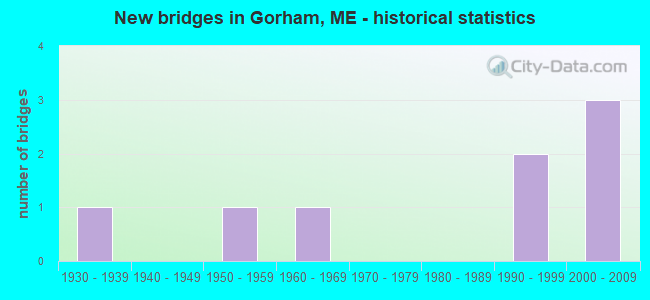
- New bridges - historical statistics
- 11930-1939
- 11950-1959
- 11960-1969
- 21990-1999
- 32000-2009


- Bridge Condition - Deck
- 20.0%Very good
- 60.0%Good
- 20.0%Fair

- Bridge Condition - Superstructure
- 40.0%Very good
- 40.0%Good
- 20.0%Satisfactory

- Bridge Condition - Substructure
- 60.0%Very good
- 40.0%Satisfactory

- Bridge Condition - Channel
- 14.3%Excellent
- 42.9%Very good
- 28.6%Good
- 14.3%Satisfactory

- Bridge Condition - Culverts
- 33.3%Good
- 66.7%Fair
Find on map >> Show street view
Structure Number: 2219, Location: 1.6 MI W JCT RTE 4 (Lat: 43.684400, Lng: -70.476781), Route carried "on" structure: State highway 25, Year Built: 1932, Year Reconstructed: 1989, Status: Open, Structure Length: 1.04m (3.41ft), Average Daily Traffic: 15,590 (year 2016), Truck Traffic: 5%, Average Future Daily Traffic: 21,826 (year 2036), Design Load: H 20, Features Intersected: LITTLE RIVER
Minimum Vertical Clearance: 30+ m (98+ ft), Kilometerpoint: 19.972, Lanes on structure: 2, Base Highway Network: Yes, Owner: State Highway Agency, Approaching Roadway Width: 12.2m (40.0ft), Material/Design: Concrete, Design/Construction: Slab, Number Of Spans In Main Unit: 1, Length of Maximum Span: 9.8m (32.2ft), Curb or Sidewalk Widths: Left: 0.2m (0.7ft), Right: 0.2m (0.7ft), Curb-To-Curb Width: 12.5m (41.0ft), Out-to-Out Width: 13.4m (44.0ft)
Condition: Deck: Good, Superstructure: Good, Substructure: Satisfactory, Channel: Very good, Operating Rating: 52.2 metric tons, Method Used To Determine Operating Rating: Load and Resistance Factor Rating (LRFR) rating reported by rating factor(RF) method using HL-93 loadings, Inventory Rating: 40.2 metric tons, Method Used To Determine Inventory Rating: Load and Resistance Factor Rating (LRFR) rating reported by rating factor(RF) method using HL-93 loadings, Structural Evaluation: Equal to present minimum criteria, Deck Geometry: Somewhat better than minimum adequacy, Waterway Adequacy: Superior to present desirable criteria, Approach Roadway Alignment: Equal to present desirable criteria, Designated Inspection Frequency: Every 24 months, Inspection Date: October 2021, Deck Structure Type: Concrete Cast-file-Place, Wearing Surface/Protective System: Wearing Surface: Bituminous, Membrane: Preformed Fabric
Find on map >> Show street view
Structure Number: 3304, Location: 2.2 MI N 25 ON 114 (Lat: 43.709511, Lng: -70.460019), Route carried "on" structure: State highway 114, Year Built: 1992, Status: Open, Structure Length: 1.26m (4.13ft), Average Daily Traffic: 4,605 (year 2016), Truck Traffic: 5%, Average Future Daily Traffic: 6,447 (year 2036), Design Load: HS 25 or greater, Features Intersected: LITTLE RIVER
Minimum Vertical Clearance: 30+ m (98+ ft), Kilometerpoint: 18.507, Lanes on structure: 2, Owner: State Highway Agency, Approaching Roadway Width: 12.8m (42.0ft), Skew: 1 degrees, Material/Design: Concrete, Design/Construction: Culvert, Number Of Spans In Main Unit: 1, Length of Maximum Span: 11.1m (36.4ft)
Condition: Channel: Very good, Culverts: Fair, Operating Rating: 46.3 metric tons, Method Used To Determine Operating Rating: Load and Resistance Factor Rating (LRFR) rating reported by rating factor(RF) method using HL-93 loadings, Inventory Rating: 35.6 metric tons, Method Used To Determine Inventory Rating: Load and Resistance Factor Rating (LRFR) rating reported by rating factor(RF) method using HL-93 loadings, Structural Evaluation: Somewhat better than minimum adequacy, Waterway Adequacy: Equal to present desirable criteria, Approach Roadway Alignment: Equal to present desirable criteria, Designated Inspection Frequency: Every 24 months, Inspection Date: October 2021
Find on map >> Show street view
Structure Number: 5303, Location: 0.2 MI N OF JCT ROUTE 22 (Lat: 43.643611, Lng: -70.421639), Route carried "on" structure: State highway 114, Year Built: 1951, Status: Open, Structure Length: 1.34m (4.40ft), Average Daily Traffic: 13,270 (year 2016), Truck Traffic: 5%, Average Future Daily Traffic: 18,578 (year 2036), Design Load: H 20, Features Intersected: STROUDWATER RIVER
Minimum Vertical Clearance: 30+ m (98+ ft), Kilometerpoint: 10.589, Lanes on structure: 2, Base Highway Network: Yes, Owner: State Highway Agency, Approaching Roadway Width: 10.4m (34.1ft), Material/Design: Concrete, Design/Construction: Tee Beam, Number Of Spans In Main Unit: 1, Length of Maximum Span: 12.2m (40.0ft), Curb or Sidewalk Widths: Left: 0.2m (0.7ft), Right: 0.2m (0.7ft), Curb-To-Curb Width: 8.0m (26.2ft), Out-to-Out Width: 9.2m (30.2ft)
Condition: Deck: Fair, Superstructure: Satisfactory, Substructure: Satisfactory, Channel: Good, Operating Rating: 29.2 metric tons, Method Used To Determine Operating Rating: Load and Resistance Factor Rating (LRFR) rating reported by rating factor(RF) method using HL-93 loadings, Inventory Rating: 20.7 metric tons, Method Used To Determine Inventory Rating: Load and Resistance Factor Rating (LRFR) rating reported by rating factor(RF) method using HL-93 loadings, Structural Evaluation: Somewhat better than minimum adequacy, Deck Geometry: High priority of replacement, Waterway Adequacy: Equal to present desirable criteria, Approach Roadway Alignment: Equal to present desirable criteria, Designated Inspection Frequency: Every 24 months, Inspection Date: March 2021, Deck Structure Type: Concrete Cast-file-Place, Wearing Surface/Protective System: Wearing Surface: Bituminous
Find on map >> Show street view
Structure Number: 5737, Location: 0.2 MI E OF JCT RTE 114 (Lat: 43.718061, Lng: -70.461611), Route carried "on" structure: City street , Year Built: 1966, Status: Open, Structure Length: 1.09m (3.58ft), Average Daily Traffic: 4,553 (year 2016), Truck Traffic: 5%, Average Future Daily Traffic: 6,374 (year 2036), Design Load: H 20, Features Intersected: N BRANCH LITTLE RIVER, Facility Carried by Structure: HUSTON ROAD
Minimum Vertical Clearance: 30+ m (98+ ft), Kilometerpoint: 0.257, Lanes on structure: 2, Owner: State Highway Agency, Approaching Roadway Width: 10.4m (34.1ft), Skew: 2 degrees, Material/Design: Steel, Design/Construction: Culvert, Number Of Spans In Main Unit: 2, Length of Maximum Span: 4.8m (15.7ft)
Condition: Channel: Satisfactory, Culverts: Fair, Operating Rating: 97.2 metric tons, Method Used To Determine Operating Rating: Load and Resistance Factor Rating (LRFR) rating reported by rating factor(RF) method using HL-93 loadings, Inventory Rating: 97.2 metric tons, Method Used To Determine Inventory Rating: Load and Resistance Factor Rating (LRFR) rating reported by rating factor(RF) method using HL-93 loadings, Structural Evaluation: Somewhat better than minimum adequacy, Waterway Adequacy: Equal to present minimum criteria, Approach Roadway Alignment: Equal to present desirable criteria, Designated Inspection Frequency: Every 24 months, Inspection Date: October 2021
Find on map >> Show street view
Structure Number: 6368, Location: 0.4 MI S NEW PORTLAND RD (Lat: 43.673100, Lng: -70.410711), Route carried "on" structure: County highway , Year Built: 1992, Status: Open, Structure Length: 0.61m (2.00ft), Average Daily Traffic: 4,440 (year 2016), Truck Traffic: 5%, Average Future Daily Traffic: 6,216 (year 2036), Design Load: HS 20, Features Intersected: INDIAN CAMP BROOK, Facility Carried by Structure: BRACKET ROAD
Minimum Vertical Clearance: 30+ m (98+ ft), Kilometerpoint: 0.595, Lanes on structure: 2, Owner: State Highway Agency, Approaching Roadway Width: 9.1m (29.9ft), Material/Design: Concrete, Design/Construction: Culvert, Number Of Spans In Main Unit: 1, Length of Maximum Span: 6.1m (20.0ft)
Condition: Channel: Good, Culverts: Good, Operating Rating: 42.1 metric tons, Method Used To Determine Operating Rating: Load and Resistance Factor Rating (LRFR) rating reported by rating factor(RF) method using HL-93 loadings, Inventory Rating: 32.4 metric tons, Method Used To Determine Inventory Rating: Load and Resistance Factor Rating (LRFR) rating reported by rating factor(RF) method using HL-93 loadings, Structural Evaluation: Better than present minimum criteria, Waterway Adequacy: Equal to present desirable criteria, Approach Roadway Alignment: Equal to present desirable criteria, Designated Inspection Frequency: Every 24 months, Inspection Date: October 2021
Find on map >> Show street view
Structure Number: 6443, Location: .2 mi W. of Cressey Road (Lat: 43.674719, Lng: -70.463439), Route carried "on" structure: City street , Year Built: 2008, Status: Open, Structure Length: 4.24m (13.91ft), Average Daily Traffic: 2,239 (year 2016), Truck Traffic: 5%, Average Future Daily Traffic: 3,135 (year 2036), Design Load: HL 93, Features Intersected: US Route 112, Facility Carried by Structure: Flaggy Meadow Road
Minimum Vertical Clearance: 30+ m (98+ ft), Kilometerpoint: 2.012, Lanes on structure: 2, Lanes under structure: 2, Owner: State Highway Agency, Approaching Roadway Width: 8.8m (28.9ft), Material/Design: Prestressed concrete continuous, Design/Construction: Box Beam or Girders - Multiple, Number Of Spans In Main Unit: 3, Length of Maximum Span: 26.2m (86.0ft), Curb-To-Curb Width: 8.8m (28.9ft), Out-to-Out Width: 8.8m (28.9ft)
Condition: Deck: Good, Superstructure: Good, Substructure: Very good, Operating Rating: 52.5 metric tons, Method Used To Determine Operating Rating: Load and Resistance Factor Rating (LRFR) rating reported by rating factor(RF) method using HL-93 loadings, Inventory Rating: 41.5 metric tons, Method Used To Determine Inventory Rating: Load and Resistance Factor Rating (LRFR) rating reported by rating factor(RF) method using HL-93 loadings, Structural Evaluation: Better than present minimum criteria, Deck Geometry: High priority of corrective action, Underclear: Superior to present desirable criteria, Approach Roadway Alignment: Equal to present desirable criteria, Designated Inspection Frequency: Every 24 months, Inspection Date: October 2020, Deck Structure Type: Concrete Cast-file-Place, Wearing Surface/Protective System: Wearing Surface: Bituminous, Membrane: Preformed Fabric
Find on map >> Show street view
Structure Number: 6444, Location: 1.5 MI NW JCT RTE 114 (Lat: 43.657461, Lng: -70.449139), Route carried "on" structure: State highway 112, Year Built: 2008, Status: Open, Structure Length: 4.19m (13.75ft), Average Daily Traffic: 8,716 (year 2016), Truck Traffic: 5%, Average Future Daily Traffic: 12,202 (year 2036), Design Load: HS 25 or greater, Features Intersected: GULLY BROOK
Minimum Vertical Clearance: 30+ m (98+ ft), Kilometerpoint: 39.059, Lanes on structure: 2, Base Highway Network: Yes, Owner: State Highway Agency, Approaching Roadway Width: 11.9m (39.0ft), Skew: 2 degrees, Material/Design: Steel, Design/Construction: Stringer/Multi-beam, Number Of Spans In Main Unit: 1, Length of Maximum Span: 40.4m (132.5ft), Curb-To-Curb Width: 12.2m (40.0ft), Out-to-Out Width: 13.1m (43.0ft)
Condition: Deck: Very good, Superstructure: Very good, Substructure: Very good, Channel: Excellent, Operating Rating: 82.0 metric tons, Method Used To Determine Operating Rating: Load and Resistance Factor Rating (LRFR) rating reported by rating factor(RF) method using HL-93 loadings, Inventory Rating: 63.2 metric tons, Method Used To Determine Inventory Rating: Load and Resistance Factor Rating (LRFR) rating reported by rating factor(RF) method using HL-93 loadings, Structural Evaluation: Equal to present desirable criteria, Deck Geometry: Somewhat better than minimum adequacy, Waterway Adequacy: Superior to present desirable criteria, Approach Roadway Alignment: Equal to present desirable criteria, Designated Inspection Frequency: Every 24 months, Inspection Date: October 2020, Deck Structure Type: Concrete Precast Panels, Wearing Surface/Protective System: Wearing Surface: Bituminous, Membrane: Preformed Fabric
Find on map >> Show street view
Structure Number: 6445, Location: 0.8 MI W OF JCT RTE 114 (Lat: 43.648761, Lng: -70.443219), Route carried "on" structure: State highway 112, Year Built: 2008, Status: Open, Structure Length: 4.19m (13.75ft), Average Daily Traffic: 8,716 (year 2016), Truck Traffic: 5%, Average Future Daily Traffic: 12,202 (year 2036), Design Load: HS 25 or greater, Features Intersected: TRIBUTARY OF GULLY BROOK
Minimum Vertical Clearance: 30+ m (98+ ft), Kilometerpoint: 40.201, Lanes on structure: 2, Base Highway Network: Yes, Owner: State Highway Agency, Approaching Roadway Width: 11.9m (39.0ft), Material/Design: Steel, Design/Construction: Stringer/Multi-beam, Number Of Spans In Main Unit: 1, Length of Maximum Span: 40.4m (132.5ft), Curb-To-Curb Width: 12.2m (40.0ft), Out-to-Out Width: 13.1m (43.0ft)
Condition: Deck: Good, Superstructure: Very good, Substructure: Very good, Channel: Very good, Operating Rating: 84.6 metric tons, Method Used To Determine Operating Rating: Load and Resistance Factor Rating (LRFR) rating reported by rating factor(RF) method using HL-93 loadings, Inventory Rating: 65.1 metric tons, Method Used To Determine Inventory Rating: Load and Resistance Factor Rating (LRFR) rating reported by rating factor(RF) method using HL-93 loadings, Structural Evaluation: Equal to present desirable criteria, Deck Geometry: Somewhat better than minimum adequacy, Waterway Adequacy: Superior to present desirable criteria, Approach Roadway Alignment: Equal to present desirable criteria, Designated Inspection Frequency: Every 24 months, Inspection Date: October 2020, Deck Structure Type: Concrete Precast Panels, Wearing Surface/Protective System: Wearing Surface: Bituminous, Membrane: Preformed Fabric
Find on map >> Show street view
Location: 0.5 MI N RTE 1 CONN. (Lat: 43.626978, Lng: -70.446108), Route carried "on" structure: City street 32310, Structure Length: 0. m, Average Daily Traffic: 12,752 (year 2014), Truck Traffic: 7%, Features Intersected: I-295 SOUTHBOUND, Facility Carried by Structure: STATE ROUTE 703
Minimum Vertical Clearance: 4.77m (15.65ft), Kilometerpoint: 2.028, Lanes on structure: 4, Length of Maximum Span: 0.0m
Find on map >> Show street view
Location: 0.5 MI S OF JCT RTE 25 (Lat: 43.672539, Lng: -70.438697), Route carried "on" structure: Spur City street 52310, Structure Length: 0. m, Average Daily Traffic: 6,320 (year 2014), Truck Traffic: 7%, Features Intersected: WOODLAWN AVENUE, Facility Carried by Structure: WESTBROOK ARTERIAL
Minimum Vertical Clearance: 4.88m (16.01ft), Kilometerpoint: 8.111, Lanes on structure: 4, Length of Maximum Span: 0.0m