Bridge Statistics for Erlanger, Kentucky (KY)
Condition, Traffic, Stress, Structural Evaluation, Project Costs
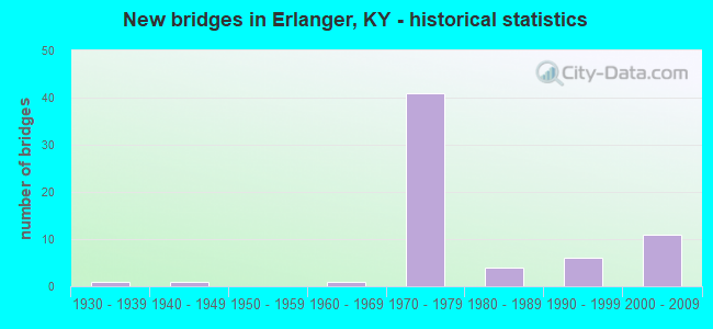
- New bridges - historical statistics
- 11930-1939
- 11940-1949
- 11960-1969
- 411970-1979
- 41980-1989
- 61990-1999
- 112000-2009

- Reconstructed bridges - Historical Statistics
- 11950-1959
- 01960-1969
- 01970-1979
- 21980-1989


- Bridge Condition - Deck
- 47.8%Good
- 43.5%Satisfactory
- 8.7%Fair

- Bridge Condition - Superstructure
- 17.4%Very good
- 60.9%Good
- 21.7%Fair

- Bridge Condition - Substructure
- 73.9%Good
- 17.4%Satisfactory
- 8.7%Fair

- Bridge Condition - Channel
- 11.1%Very good
- 44.4%Good
- 22.2%Satisfactory
- 22.2%Fair

- Bridge Condition - Culverts
- 50.0%Good
- 25.0%Satisfactory
- 25.0%Poor
Find on map >> Show street view
Structure Number: 8B00053N, Location: .25 MI NE OF JCT KY 236 (Lat: 39.057778, Lng: -84.637222), Route carried "on" structure: County highway 1032, Year Built: 1973, Status: Open, Structure Length: 7.32m (24.02ft), Average Daily Traffic: 541 (year 2006), Average Future Daily Traffic: 2,026 (year 2026), Design Load: H 20, Features Intersected: I-275, Facility Carried by Structure: POINT PLEASANT RD
Minimum Vertical Clearance: 30+ m (98+ ft), Kilometerpoint: 0.584, Lanes on structure: 2, Lanes under structure: 6, Owner: State Highway Agency, Approaching Roadway Width: 9.8m (32.2ft), Skew: 23 degrees, Material/Design: Steel continuous, Design/Construction: Stringer/Multi-beam, Number Of Spans In Main Unit: 2, Length of Maximum Span: 36.6m (120.1ft), Curb or Sidewalk Widths: Left: 0.5m (1.6ft), Right: 0.5m (1.6ft), Curb-To-Curb Width: 8.5m (27.9ft), Out-to-Out Width: 9.7m (31.8ft)
Condition: Deck: Good, Superstructure: Good, Substructure: Good, Operating Rating: 59.4 metric tons, Method Used To Determine Operating Rating: Load Factor (LF), Inventory Rating: 35.7 metric tons, Method Used To Determine Inventory Rating: Load Factor (LF), Structural Evaluation: Better than present minimum criteria, Deck Geometry: Somewhat better than minimum adequacy, Underclear: Equal to present minimum criteria, Approach Roadway Alignment: Equal to present minimum criteria, Designated Inspection Frequency: Every 24 months, Inspection Date: June 2021, Deck Structure Type: Concrete Cast-file-Place, Wearing Surface/Protective System: Wearing Surface: Latex Concrete
Find on map >> Show street view
Structure Number: 8B00066N, Location: 1 MI E OF JCT KY 236 (Lat: 39.054722, Lng: -84.626389), Route carried "on" structure: State highway 3076, Year Built: 1985, Status: Open, Structure Length: 9.30m (30.51ft), Average Daily Traffic: 13,855 (year 2018), Truck Traffic: 11%, Average Future Daily Traffic: 12,885 (year 2038), Design Load: HS 20, Features Intersected: I-275, Facility Carried by Structure: DOLWICK DRIVE
Minimum Vertical Clearance: 30+ m (98+ ft), Kilometerpoint: 1.675, Lanes on structure: 2, Lanes under structure: 6, Owner: State Highway Agency, Approaching Roadway Width: 18.3m (60.0ft), Skew: 2 degrees, Material/Design: Prestressed concrete continuous, Design/Construction: Stringer/Multi-beam, Number Of Spans In Main Unit: 4, Length of Maximum Span: 32.6m (107.0ft), Curb or Sidewalk Widths: Left: 0.5m (1.6ft), Right: 0.5m (1.6ft), Curb-To-Curb Width: 16.5m (54.1ft), Out-to-Out Width: 17.5m (57.4ft)
Condition: Deck: Satisfactory, Superstructure: Good, Substructure: Good, Operating Rating: 72.6 metric tons, Method Used To Determine Operating Rating: Load Factor (LF), Inventory Rating: 43.5 metric tons, Method Used To Determine Inventory Rating: Load Factor (LF), Structural Evaluation: Better than present minimum criteria, Deck Geometry: Superior to present desirable criteria, Underclear: Somewhat better than minimum adequacy, Approach Roadway Alignment: Equal to present desirable criteria, Designated Inspection Frequency: Every 24 months, Inspection Date: June 2021, Deck Structure Type: Concrete Cast-file-Place, Wearing Surface/Protective System: Wearing Surface: Monolithic Concrete, Deck Protection: Epoxy Coated Reinforcing
Find on map >> Show street view
Structure Number: 59B00034N, Location: .25 MI WEST OF I-75 (Lat: 39.027778, Lng: -84.615556), Route carried "on" structure: State highway 236, Year Built: 1943, Year Reconstructed: 1961, Status: Open, Structure Length: 1.06m (3.48ft), Average Daily Traffic: 12,839 (year 2020), Truck Traffic: 13%, Average Future Daily Traffic: 11,940 (year 2040), Design Load: H 15, Features Intersected: VIOX CREEK, Facility Carried by Structure: DONALDSON ROAD
Minimum Vertical Clearance: 30+ m (98+ ft), Kilometerpoint: 4.184, Lanes on structure: 4, Owner: State Highway Agency, Approaching Roadway Width: 30.5m (100.1ft), Skew: 23 degrees, Material/Design: Concrete, Design/Construction: Culvert, Number Of Spans In Main Unit: 2, Length of Maximum Span: 4.9m (16.1ft)
Condition: Channel: Good, Culverts: Satisfactory, Operating Rating: 54.4 metric tons, Method Used To Determine Operating Rating: Field evaluation and documented engineering judgment, Inventory Rating: 39.9 metric tons, Method Used To Determine Inventory Rating: Field evaluation and documented engineering judgment, Structural Evaluation: Equal to present minimum criteria, Waterway Adequacy: Better than present minimum criteria, Approach Roadway Alignment: Better than present minimum criteria, Designated Inspection Frequency: Every 24 months, Inspection Date: October 2021
Find on map >> Show street view
Structure Number: 59B00053L, Location: SB MAINLINE I75 @I275 NTR (Lat: 39.035000, Lng: -84.599722), Route carried "on" structure: Interstate 75, Year Built: 1971, Year Reconstructed: 1994, Status: Open, Structure Length: 7.63m (25.03ft), Average Daily Traffic: 78,973 (year 2020), Truck Traffic: 18%, Average Future Daily Traffic: 84,501 (year 2040), Design Load: HS 20+Mod, Features Intersected: I275 E&W-RAMPS D-G
Minimum Vertical Clearance: 30+ m (98+ ft), Kilometerpoint: 297.188, Lanes on structure: 3, Lanes under structure: 2, Base Highway Network: Yes, Owner: State Highway Agency, Approaching Roadway Width: 18.9m (62.0ft), Skew: 3 degrees, Material/Design: Steel continuous, Design/Construction: Stringer/Multi-beam, Number Of Spans In Main Unit: 4, Length of Maximum Span: 21.9m (71.9ft), Curb-To-Curb Width: 18.9m (62.0ft), Out-to-Out Width: 19.9m (65.3ft)
Condition: Deck: Satisfactory, Superstructure: Good, Substructure: Good, Operating Rating: 51.5 metric tons, Method Used To Determine Operating Rating: Load Factor (LF), Inventory Rating: 30.9 metric tons, Method Used To Determine Inventory Rating: Load Factor (LF), Structural Evaluation: Better than present minimum criteria, Deck Geometry: Superior to present desirable criteria, Underclear: Somewhat better than minimum adequacy, Approach Roadway Alignment: Equal to present desirable criteria, Designated Inspection Frequency: Every 24 months, Critical Feature Inspection Frequency: Every 24 months, Inspection Date: September 2021, Critical Feature Inspection Date: September 2021, Deck Structure Type: Concrete Cast-file-Place, Wearing Surface/Protective System: Wearing Surface: Low Slump Concrete
Find on map >> Show street view
Structure Number: 59B00053R, Location: NB MAINLINE I75 @I275 NTR (Lat: 39.034722, Lng: -84.599444), Route carried "on" structure: Interstate 75, Year Built: 1971, Year Reconstructed: 1994, Status: Open, Structure Length: 7.81m (25.62ft), Average Daily Traffic: 78,973 (year 2020), Truck Traffic: 18%, Average Future Daily Traffic: 84,501 (year 2040), Design Load: HS 20+Mod, Features Intersected: I275 E&W-RAMPS D-G
Minimum Vertical Clearance: 30+ m (98+ ft), Kilometerpoint: 297.225, Lanes on structure: 3, Lanes under structure: 2, Base Highway Network: Yes, Owner: State Highway Agency, Approaching Roadway Width: 18.9m (62.0ft), Skew: 3 degrees, Material/Design: Steel continuous, Design/Construction: Stringer/Multi-beam, Number Of Spans In Main Unit: 4, Length of Maximum Span: 21.9m (71.9ft), Curb-To-Curb Width: 18.9m (62.0ft), Out-to-Out Width: 19.9m (65.3ft)
Condition: Deck: Satisfactory, Superstructure: Good, Substructure: Good, Operating Rating: 54.1 metric tons, Method Used To Determine Operating Rating: Load Factor (LF), Inventory Rating: 32.5 metric tons, Method Used To Determine Inventory Rating: Load Factor (LF), Structural Evaluation: Better than present minimum criteria, Deck Geometry: Superior to present desirable criteria, Underclear: Somewhat better than minimum adequacy, Approach Roadway Alignment: Superior to present desirable criteria, Designated Inspection Frequency: Every 24 months, Critical Feature Inspection Frequency: Every 24 months, Inspection Date: September 2021, Critical Feature Inspection Date: September 2021, Deck Structure Type: Concrete Cast-file-Place, Wearing Surface/Protective System: Wearing Surface: Latex Concrete
Find on map >> Show street view
Structure Number: 59B00054L, Location: WBI275@I75 (Lat: 39.034722, Lng: -84.599444), Route carried "on" structure: Interstate 275, Year Built: 1971, Status: Open, Structure Length: 12.69m (41.63ft), Average Daily Traffic: 43,613 (year 2018), Truck Traffic: 16%, Average Future Daily Traffic: 46,666 (year 2038), Design Load: HS 20+Mod, Features Intersected: I-75 N&S-RAMPS G-D
Minimum Vertical Clearance: 30+ m (98+ ft), Kilometerpoint: 0.031, Lanes on structure: 3, Lanes under structure: 8, Base Highway Network: Yes, Owner: State Highway Agency, Approaching Roadway Width: 16.5m (54.1ft), Skew: 13 degrees, Material/Design: Steel continuous, Design/Construction: Stringer/Multi-beam, Number Of Spans In Main Unit: 4, Length of Maximum Span: 36.8m (120.7ft), Curb-To-Curb Width: 15.8m (51.8ft), Out-to-Out Width: 16.8m (55.1ft)
Condition: Deck: Fair, Superstructure: Fair, Substructure: Good, Operating Rating: 42.4 metric tons, Method Used To Determine Operating Rating: Load and Resistance Factor Rating (LRFR) rating reported by rating factor(RF) method using HL-93 loadings, Inventory Rating: 24.3 metric tons, Method Used To Determine Inventory Rating: Load and Resistance Factor Rating (LRFR) rating reported by rating factor(RF) method using HL-93 loadings, Structural Evaluation: Somewhat better than minimum adequacy, Deck Geometry: Somewhat better than minimum adequacy, Underclear: High priority of corrective action, Approach Roadway Alignment: Superior to present desirable criteria, Length Of Structure Improvement: 1.26m (4.13ft), Designated Inspection Frequency: Every 24 months, Critical Feature Inspection Frequency: Every 24 months, Inspection Date: September 2021, Critical Feature Inspection Date: September 2021, Bridge Improvement Cost: $2,839,000, Total Project Cost: $2,839,000, Deck Structure Type: Concrete Cast-file-Place, Wearing Surface/Protective System: Wearing Surface: Low Slump Concrete
Find on map >> Show street view
Structure Number: 59B00054R, Location: EB-275 MAINLINE@I75 (Lat: 39.035000, Lng: -84.599444), Route carried "on" structure: Interstate 275, Year Built: 1971, Status: Open, Structure Length: 12.64m (41.47ft), Average Daily Traffic: 43,613 (year 2018), Truck Traffic: 16%, Average Future Daily Traffic: 46,666 (year 2038), Design Load: HS 20+Mod, Features Intersected: I-75 N&S-RAMPS G-D
Minimum Vertical Clearance: 30+ m (98+ ft), Kilometerpoint: 0.031, Lanes on structure: 3, Lanes under structure: 8, Base Highway Network: Yes, Owner: State Highway Agency, Approaching Roadway Width: 16.5m (54.1ft), Skew: 13 degrees, Material/Design: Steel continuous, Design/Construction: Stringer/Multi-beam, Number Of Spans In Main Unit: 4, Length of Maximum Span: 36.0m (118.1ft), Curb-To-Curb Width: 15.6m (51.2ft), Out-to-Out Width: 16.8m (55.1ft)
Condition: Deck: Fair, Superstructure: Fair, Substructure: Good, Operating Rating: 36.9 metric tons, Method Used To Determine Operating Rating: Load and Resistance Factor Rating (LRFR) rating reported by rating factor(RF) method using HL-93 loadings, Inventory Rating: 28.5 metric tons, Method Used To Determine Inventory Rating: Load and Resistance Factor Rating (LRFR) rating reported by rating factor(RF) method using HL-93 loadings, Structural Evaluation: Somewhat better than minimum adequacy, Deck Geometry: Somewhat better than minimum adequacy, Underclear: High priority of corrective action, Approach Roadway Alignment: Superior to present desirable criteria, Length Of Structure Improvement: 1.26m (4.13ft), Designated Inspection Frequency: Every 24 months, Critical Feature Inspection Frequency: Every 24 months, Inspection Date: September 2021, Critical Feature Inspection Date: September 2021, Bridge Improvement Cost: $2,853,000, Total Project Cost: $2,853,000, Deck Structure Type: Concrete Cast-file-Place, Wearing Surface/Protective System: Wearing Surface: Low Slump Concrete
Find on map >> Show street view
Structure Number: 59B00055N, Location: EB I275 TO NB I75 RMP-LVL (Lat: 39.035000, Lng: -84.598889), Route carried "on" structure: Ramp Interstate 75, Year Built: 1971, Status: Open, Structure Length: 27.26m (89.44ft), Average Daily Traffic: 124,179 (year 2020), Truck Traffic: 17%, Average Future Daily Traffic: 132,871 (year 2040), Design Load: HS 20+Mod, Features Intersected: I275-I75-G&D RAMPS
Minimum Vertical Clearance: 30+ m (98+ ft), Kilometerpoint: 297.260, Lanes on structure: 2, Lanes under structure: 14, Owner: State Highway Agency, Approaching Roadway Width: 10.4m (34.1ft), Skew: 10 degrees, Material/Design: Steel continuous, Design/Construction: Stringer/Multi-beam, Number Of Spans In Main Unit: 7, Length of Maximum Span: 48.2m (158.1ft), Curb-To-Curb Width: 12.0m (39.4ft), Out-to-Out Width: 13.1m (43.0ft)
Condition: Deck: Satisfactory, Superstructure: Fair, Substructure: Good, Operating Rating: 54.4 metric tons, Method Used To Determine Operating Rating: Load Factor (LF), Inventory Rating: 32.7 metric tons, Method Used To Determine Inventory Rating: Load Factor (LF), Structural Evaluation: Somewhat better than minimum adequacy, Deck Geometry: Superior to present desirable criteria, Underclear: High priority of corrective action, Approach Roadway Alignment: Better than present minimum criteria, Length Of Structure Improvement: 2.69m (8.83ft), Designated Inspection Frequency: Every 24 months, Critical Feature Inspection Frequency: Every 24 months, Inspection Date: September 2021, Critical Feature Inspection Date: September 2021, Bridge Improvement Cost: $4,741,000, Total Project Cost: $4,740,000, Deck Structure Type: Concrete Cast-file-Place, Wearing Surface/Protective System: Wearing Surface: Low Slump Concrete
Find on map >> Show street view
Structure Number: 59B00056N, Location: WB I275 TO SB I75 RMP-LVL (Lat: 39.034722, Lng: -84.599722), Route carried "on" structure: Ramp Interstate 75, Year Built: 1971, Status: Open, Structure Length: 24.59m (80.68ft), Average Daily Traffic: 157,945 (year 2020), Truck Traffic: 18%, Average Future Daily Traffic: 169,001 (year 2040), Design Load: HS 20, Features Intersected: I275-I75-G&D RAMPS
Minimum Vertical Clearance: 30+ m (98+ ft), Kilometerpoint: 297.217, Lanes on structure: 2, Lanes under structure: 14, Owner: State Highway Agency, Approaching Roadway Width: 20.7m (67.9ft), Skew: 10 degrees, Material/Design: Steel continuous, Design/Construction: Stringer/Multi-beam, Number Of Spans In Main Unit: 6, Length of Maximum Span: 48.2m (158.1ft), Curb-To-Curb Width: 12.0m (39.4ft), Out-to-Out Width: 13.1m (43.0ft)
Condition: Deck: Satisfactory, Superstructure: Fair, Substructure: Satisfactory, Operating Rating: 67.0 metric tons, Method Used To Determine Operating Rating: Load Factor (LF), Inventory Rating: 40.2 metric tons, Method Used To Determine Inventory Rating: Load Factor (LF), Structural Evaluation: Somewhat better than minimum adequacy, Deck Geometry: Superior to present desirable criteria, Underclear: High priority of corrective action, Approach Roadway Alignment: Better than present minimum criteria, Length Of Structure Improvement: 2.25m (7.38ft), Designated Inspection Frequency: Every 24 months, Critical Feature Inspection Frequency: Every 24 months, Inspection Date: September 2021, Critical Feature Inspection Date: September 2021, Bridge Improvement Cost: $3,961,000, Total Project Cost: $3,961,000, Deck Structure Type: Concrete Cast-file-Place, Wearing Surface/Protective System: Wearing Surface: Low Slump Concrete
Find on map >> Show street view
Structure Number: 59B00057N, Location: 1 MI NE OF JCT KY 236 (Lat: 39.032500, Lng: -84.593056), Route carried "on" structure: State highway 2373, Year Built: 1973, Status: Open, Structure Length: 10.91m (35.79ft), Average Daily Traffic: 4,865 (year 2020), Truck Traffic: 5%, Average Future Daily Traffic: 4,524 (year 2040), Design Load: H 20, Features Intersected: I-275 & RAMPS C,E,F, Facility Carried by Structure: ERLANGER-CRESCENT
Minimum Vertical Clearance: 30+ m (98+ ft), Kilometerpoint: 1.479, Lanes on structure: 2, Lanes under structure: 8, Owner: State Highway Agency, Approaching Roadway Width: 6.7m (22.0ft), Skew: 10 degrees, Material/Design: Steel continuous, Design/Construction: Stringer/Multi-beam, Number Of Spans In Main Unit: 3, Length of Maximum Span: 38.7m (127.0ft), Curb or Sidewalk Widths: Left: 0.6m (2.0ft), Right: 0.6m (2.0ft), Curb-To-Curb Width: 8.5m (27.9ft), Out-to-Out Width: 9.7m (31.8ft)
Condition: Deck: Satisfactory, Superstructure: Good, Substructure: Satisfactory, Operating Rating: 54.3 metric tons, Method Used To Determine Operating Rating: Load Factor (LF), Inventory Rating: 32.6 metric tons, Method Used To Determine Inventory Rating: Load Factor (LF), Structural Evaluation: Equal to present minimum criteria, Deck Geometry: Meets minimum limits, Underclear: Somewhat better than minimum adequacy, Approach Roadway Alignment: Equal to present minimum criteria, Designated Inspection Frequency: Every 24 months, Inspection Date: October 2021, Deck Structure Type: Concrete Cast-file-Place, Wearing Surface/Protective System: Wearing Surface: Latex Concrete, Deck Protection: Epoxy Coated Reinforcing
Find on map >> Show street view
Structure Number: 59B00064L, Location: WBL @ BOONE CO. LN. (Lat: 39.044444, Lng: -84.614722), Route carried "on" structure: Interstate 275, Year Built: 1970, Status: Open, Structure Length: 5.36m (17.59ft), Average Daily Traffic: 43,613 (year 2018), Truck Traffic: 16%, Average Future Daily Traffic: 46,666 (year 2038), Design Load: HS 20+Mod, Features Intersected: ERLANGER SERVICE ROAD
Minimum Vertical Clearance: 30+ m (98+ ft), Kilometerpoint: 1.749, Lanes on structure: 3, Lanes under structure: 2, Base Highway Network: Yes, Owner: State Highway Agency, Approaching Roadway Width: 16.5m (54.1ft), Skew: 10 degrees, Material/Design: Prestressed concrete continuous, Design/Construction: Stringer/Multi-beam, Number Of Spans In Main Unit: 3, Length of Maximum Span: 18.3m (60.0ft), Curb-To-Curb Width: 17.1m (56.1ft), Out-to-Out Width: 18.0m (59.1ft)
Condition: Deck: Satisfactory, Superstructure: Good, Substructure: Good, Operating Rating: 87.5 metric tons, Method Used To Determine Operating Rating: Load Factor (LF), Inventory Rating: 52.5 metric tons, Method Used To Determine Inventory Rating: Load Factor (LF), Structural Evaluation: Better than present minimum criteria, Deck Geometry: Equal to present minimum criteria, Underclear: Meets minimum limits, Approach Roadway Alignment: Superior to present desirable criteria, Length Of Structure Improvement: 0.54m (1.77ft), Designated Inspection Frequency: Every 24 months, Inspection Date: October 2021, Bridge Improvement Cost: $1,298,000, Total Project Cost: $1,298,000, Deck Structure Type: Concrete Cast-file-Place, Wearing Surface/Protective System: Wearing Surface: Latex Concrete
Find on map >> Show street view
Structure Number: 59B00064R, Location: EBL @ BOONE CO. LN. (Lat: 39.044722, Lng: -84.614722), Route carried "on" structure: Interstate 275, Year Built: 1970, Status: Open, Structure Length: 4.60m (15.09ft), Average Daily Traffic: 43,613 (year 2018), Truck Traffic: 16%, Average Future Daily Traffic: 46,666 (year 2038), Design Load: HS 20+Mod, Features Intersected: ERLANGER SERVICE ROAD
Minimum Vertical Clearance: 30+ m (98+ ft), Kilometerpoint: 1.733, Lanes on structure: 3, Lanes under structure: 2, Base Highway Network: Yes, Owner: State Highway Agency, Approaching Roadway Width: 16.5m (54.1ft), Skew: 10 degrees, Material/Design: Prestressed concrete continuous, Design/Construction: Stringer/Multi-beam, Number Of Spans In Main Unit: 3, Length of Maximum Span: 17.4m (57.1ft), Curb or Sidewalk Widths: Left: 0.5m (1.6ft), Right: 0.5m (1.6ft), Curb-To-Curb Width: 17.1m (56.1ft), Out-to-Out Width: 18.0m (59.1ft)
Condition: Deck: Good, Superstructure: Good, Substructure: Good, Operating Rating: 89.9 metric tons, Method Used To Determine Operating Rating: Load Factor (LF), Inventory Rating: 54.0 metric tons, Method Used To Determine Inventory Rating: Load Factor (LF), Structural Evaluation: Better than present minimum criteria, Deck Geometry: Equal to present minimum criteria, Underclear: Meets minimum limits, Approach Roadway Alignment: Superior to present desirable criteria, Length Of Structure Improvement: 0.46m (1.51ft), Designated Inspection Frequency: Every 24 months, Inspection Date: October 2021, Bridge Improvement Cost: $1,114,000, Total Project Cost: $1,113,000, Deck Structure Type: Concrete Cast-file-Place, Wearing Surface/Protective System: Wearing Surface: Latex Concrete
Find on map >> Show street view
Structure Number: 59B00065N, Location: .75 MI WEST OF I-75 (Lat: 39.040556, Lng: -84.610000), Route carried "on" structure: Interstate 275, Year Built: 1970, Status: Open, Structure Length: 0.94m (3.08ft), Average Daily Traffic: 87,226 (year 2018), Truck Traffic: 16%, Average Future Daily Traffic: 93,331 (year 2038), Design Load: HS 20+Mod, Features Intersected: DRY CREEK
Minimum Vertical Clearance: 30+ m (98+ ft), Kilometerpoint: 1.112, Lanes on structure: 6, Base Highway Network: Yes, Owner: State Highway Agency, Approaching Roadway Width: 17.1m (56.1ft), Skew: 2 degrees, Material/Design: Concrete, Design/Construction: Culvert, Number Of Spans In Main Unit: 1, Length of Maximum Span: 8.5m (27.9ft)
Condition: Channel: Good, Culverts: Good, Operating Rating: 99.8 metric tons, Method Used To Determine Operating Rating: Field evaluation and documented engineering judgment, Inventory Rating: 99.8 metric tons, Method Used To Determine Inventory Rating: Field evaluation and documented engineering judgment, Structural Evaluation: Better than present minimum criteria, Waterway Adequacy: Equal to present desirable criteria, Approach Roadway Alignment: Better than present minimum criteria, Designated Inspection Frequency: Every 24 months, Inspection Date: October 2021
Find on map >> Show street view
Structure Number: 59B00072N, Location: RMP E-NB I75 TO I275 E&W (Lat: 39.031667, Lng: -84.605278), Route carried "on" structure: Ramp Interstate 75, Year Built: 1977, Status: Open, Structure Length: 3.29m (10.79ft), Average Daily Traffic: 157,945 (year 2020), Truck Traffic: 18%, Average Future Daily Traffic: 169,001 (year 2040), Design Load: HS 20, Features Intersected: RAMP DONALDSON TO I-75
Minimum Vertical Clearance: 30+ m (98+ ft), Kilometerpoint: 296.612, Lanes on structure: 3, Lanes under structure: 1, Owner: State Highway Agency, Approaching Roadway Width: 13.4m (44.0ft), Skew: 6 degrees, Material/Design: Steel, Design/Construction: Stringer/Multi-beam, Number Of Spans In Main Unit: 1, Length of Maximum Span: 31.7m (104.0ft), Curb or Sidewalk Widths: Left: 0.5m (1.6ft), Right: 0.5m (1.6ft), Curb-To-Curb Width: 17.1m (56.1ft), Out-to-Out Width: 19.1m (62.7ft)
Condition: Deck: Satisfactory, Superstructure: Good, Substructure: Satisfactory, Operating Rating: 87.2 metric tons, Method Used To Determine Operating Rating: Load Factor (LF), Inventory Rating: 52.7 metric tons, Method Used To Determine Inventory Rating: Load Factor (LF), Structural Evaluation: Equal to present minimum criteria, Deck Geometry: Superior to present desirable criteria, Underclear: Equal to present minimum criteria, Approach Roadway Alignment: Equal to present desirable criteria, Designated Inspection Frequency: Every 24 months, Inspection Date: October 2021, Deck Structure Type: Concrete Cast-file-Place, Wearing Surface/Protective System: Wearing Surface: Latex Concrete, Deck Protection: Epoxy Coated Reinforcing
Find on map >> Show street view
Structure Number: 59B00093N, Location: .1 MI W. JCT KY 3035 (Lat: 38.980556, Lng: -84.541944), Route carried "on" structure: State highway 1829, Year Built: 1994, Status: Open, Structure Length: 3.93m (12.89ft), Average Daily Traffic: 6,382 (year 2020), Truck Traffic: 3%, Average Future Daily Traffic: 5,935 (year 2040), Design Load: HS 25 or greater, Features Intersected: BANKLICK CREEK, Facility Carried by Structure: RICHARDSON ROAD
Minimum Vertical Clearance: 30+ m (98+ ft), Kilometerpoint: 6.930, Lanes on structure: 2, Owner: State Highway Agency, Approaching Roadway Width: 12.2m (40.0ft), Material/Design: Prestressed concrete continuous, Design/Construction: Stringer/Multi-beam, Number Of Spans In Main Unit: 3, Length of Maximum Span: 17.7m (58.1ft), Curb or Sidewalk Widths: Left: 0.5m (1.6ft), Right: 0.5m (1.6ft), Curb-To-Curb Width: 12.2m (40.0ft), Out-to-Out Width: 13.2m (43.3ft)
Condition: Deck: Good, Superstructure: Very good, Substructure: Good, Channel: Very good, Operating Rating: 80.7 metric tons, Method Used To Determine Operating Rating: Load Factor (LF), Inventory Rating: 48.4 metric tons, Method Used To Determine Inventory Rating: Load Factor (LF), Structural Evaluation: Better than present minimum criteria, Deck Geometry: Somewhat better than minimum adequacy, Waterway Adequacy: Equal to present desirable criteria, Approach Roadway Alignment: Better than present minimum criteria, Designated Inspection Frequency: Every 24 months, Inspection Date: October 2021, Deck Structure Type: Concrete Cast-file-Place, Wearing Surface/Protective System: Wearing Surface: Monolithic Concrete, Deck Protection: Epoxy Coated Reinforcing
Find on map >> Show street view
Structure Number: 59B00094L, Location: 941' WEST JCT (NO &TP RR (Lat: 39.041111, Lng: -84.584722), Route carried "on" structure: Interstate 75, Year Built: 1993, Status: Open, Structure Length: 4.79m (15.72ft), Average Daily Traffic: 62,090 (year 2020), Truck Traffic: 17%, Average Future Daily Traffic: 66,436 (year 2040), Design Load: HS 25 or greater, Features Intersected: KY 2373 (CRESCENT SPRING
Minimum Vertical Clearance: 30+ m (98+ ft), Kilometerpoint: 298.702, Lanes on structure: 4, Lanes under structure: 2, Base Highway Network: Yes, Owner: State Highway Agency, Approaching Roadway Width: 27.4m (89.9ft), Skew: 2 degrees, Material/Design: Prestressed concrete continuous, Design/Construction: Stringer/Multi-beam, Number Of Spans In Main Unit: 3, Length of Maximum Span: 16.2m (53.1ft), Curb or Sidewalk Widths: Left: 0.5m (1.6ft), Right: 0.5m (1.6ft), Curb-To-Curb Width: 21.3m (69.9ft), Out-to-Out Width: 22.3m (73.2ft)
Condition: Deck: Good, Superstructure: Good, Substructure: Good, Operating Rating: 90.8 metric tons, Method Used To Determine Operating Rating: Load Factor (LF), Inventory Rating: 54.5 metric tons, Method Used To Determine Inventory Rating: Load Factor (LF), Structural Evaluation: Better than present minimum criteria, Deck Geometry: Better than present minimum criteria, Underclear: Better than present minimum criteria, Approach Roadway Alignment: Superior to present desirable criteria, Length Of Structure Improvement: 0.48m (1.57ft), Designated Inspection Frequency: Every 24 months, Inspection Date: November 2021, Bridge Improvement Cost: $1,433,000, Total Project Cost: $1,432,000, Deck Structure Type: Concrete Cast-file-Place, Wearing Surface/Protective System: Wearing Surface: Monolithic Concrete, Deck Protection: Epoxy Coated Reinforcing
Find on map >> Show street view
Structure Number: 59B00094R, Location: 941' WEST JCT (NO &TP RR (Lat: 39.040833, Lng: -84.585000), Route carried "on" structure: Interstate 75, Year Built: 1993, Status: Open, Structure Length: 4.79m (15.72ft), Average Daily Traffic: 62,090 (year 2020), Truck Traffic: 17%, Average Future Daily Traffic: 66,436 (year 2040), Design Load: HS 25 or greater, Features Intersected: KY 2373 (CRESCENT SP. RD
Minimum Vertical Clearance: 30+ m (98+ ft), Kilometerpoint: 298.680, Lanes on structure: 4, Lanes under structure: 2, Base Highway Network: Yes, Owner: State Highway Agency, Approaching Roadway Width: 21.3m (69.9ft), Skew: 2 degrees, Material/Design: Prestressed concrete continuous, Design/Construction: Stringer/Multi-beam, Number Of Spans In Main Unit: 3, Length of Maximum Span: 16.2m (53.1ft), Curb or Sidewalk Widths: Left: 0.5m (1.6ft), Right: 0.5m (1.6ft), Curb-To-Curb Width: 21.3m (69.9ft), Out-to-Out Width: 22.3m (73.2ft)
Condition: Deck: Good, Superstructure: Good, Substructure: Good, Operating Rating: 90.8 metric tons, Method Used To Determine Operating Rating: Load Factor (LF), Inventory Rating: 54.5 metric tons, Method Used To Determine Inventory Rating: Load Factor (LF), Structural Evaluation: Better than present minimum criteria, Deck Geometry: Better than present minimum criteria, Underclear: Better than present minimum criteria, Approach Roadway Alignment: Superior to present desirable criteria, Length Of Structure Improvement: 0.48m (1.57ft), Designated Inspection Frequency: Every 24 months, Inspection Date: November 2021, Bridge Improvement Cost: $1,433,000, Total Project Cost: $1,432,000, Deck Structure Type: Concrete Cast-file-Place, Wearing Surface/Protective System: Wearing Surface: Monolithic Concrete, Deck Protection: Epoxy Coated Reinforcing
Find on map >> Show street view
Structure Number: 59B00095L, Location: .5 MI SW JCT KY NBL (Lat: 39.040833, Lng: -84.585000), Route carried "on" structure: Interstate 75, Year Built: 1993, Status: Open, Structure Length: 7.86m (25.79ft), Average Daily Traffic: 62,090 (year 2020), Truck Traffic: 17%, Average Future Daily Traffic: 66,436 (year 2040), Design Load: HS 25 or greater, Features Intersected: NS (CNO&TP) SYSTEM
Minimum Vertical Clearance: 30+ m (98+ ft), Kilometerpoint: 298.982, Lanes on structure: 4, Base Highway Network: Yes, Owner: State Highway Agency, Approaching Roadway Width: 21.3m (69.9ft), Skew: 4 degrees, Material/Design: Steel continuous, Design/Construction: Stringer/Multi-beam, Number Of Spans In Main Unit: 3, Length of Maximum Span: 30.5m (100.1ft), Curb or Sidewalk Widths: Left: 0.5m (1.6ft), Right: 0.5m (1.6ft), Curb-To-Curb Width: 21.3m (69.9ft), Out-to-Out Width: 22.3m (73.2ft)
Condition: Deck: Good, Superstructure: Good, Substructure: Good, Operating Rating: 63.2 metric tons, Method Used To Determine Operating Rating: Load Factor (LF), Inventory Rating: 37.8 metric tons, Method Used To Determine Inventory Rating: Load Factor (LF), Structural Evaluation: Better than present minimum criteria, Deck Geometry: Better than present minimum criteria, Underclear: Superior to present desirable criteria, Approach Roadway Alignment: Superior to present desirable criteria, Designated Inspection Frequency: Every 24 months, Inspection Date: November 2021, Deck Structure Type: Concrete Cast-file-Place, Wearing Surface/Protective System: Wearing Surface: Monolithic Concrete, Deck Protection: Epoxy Coated Reinforcing
Find on map >> Show street view
Structure Number: 59B00102L, Location: .4 MI. NE BOONE CO LINE (Lat: 39.025833, Lng: -84.612778), Route carried "on" structure: Interstate 75, Year Built: 2001, Status: Open, Structure Length: 4.88m (16.01ft), Average Daily Traffic: 78,973 (year 2020), Truck Traffic: 18%, Average Future Daily Traffic: 84,501 (year 2040), Design Load: HS 25 or greater, Features Intersected: DONALDSON RD (KY 236)
Minimum Vertical Clearance: 30+ m (98+ ft), Kilometerpoint: 295.627, Lanes on structure: 3, Lanes under structure: 5, Base Highway Network: Yes, Owner: State Highway Agency, Approaching Roadway Width: 18.3m (60.0ft), Skew: 20 degrees, Material/Design: Prestressed concrete, Design/Construction: Box Beam or Girders - Multiple, Number Of Spans In Main Unit: 2, Length of Maximum Span: 32.3m (106.0ft), Curb or Sidewalk Widths: Left: 0.5m (1.6ft), Right: 0.5m (1.6ft), Curb-To-Curb Width: 18.4m (60.4ft), Out-to-Out Width: 19.2m (63.0ft)
Condition: Deck: Good, Superstructure: Very good, Substructure: Good, Operating Rating: 61.9 metric tons, Method Used To Determine Operating Rating: Load Factor (LF), Inventory Rating: 37.1 metric tons, Method Used To Determine Inventory Rating: Load Factor (LF), Structural Evaluation: Better than present minimum criteria, Deck Geometry: Equal to present desirable criteria, Underclear: Equal to present minimum criteria, Approach Roadway Alignment: Superior to present desirable criteria, Length Of Structure Improvement: 0.49m (1.61ft), Designated Inspection Frequency: Every 24 months, Inspection Date: October 2021, Bridge Improvement Cost: $1,260,000, Total Project Cost: $1,260,000, Deck Structure Type: Concrete Cast-file-Place, Wearing Surface/Protective System: Wearing Surface: Monolithic Concrete, Deck Protection: Epoxy Coated Reinforcing
Find on map >> Show street view
Structure Number: 59B00102R, Location: .4 MI.NE JCT BOONE CO. (Lat: 39.025833, Lng: -84.612778), Route carried "on" structure: Interstate 75, Year Built: 2001, Status: Open, Structure Length: 4.88m (16.01ft), Average Daily Traffic: 78,973 (year 2020), Truck Traffic: 18%, Average Future Daily Traffic: 84,501 (year 2040), Design Load: HS 25 or greater, Features Intersected: DONALDSON ROAD (KY 236)
Minimum Vertical Clearance: 30+ m (98+ ft), Kilometerpoint: 295.636, Lanes on structure: 4, Lanes under structure: 5, Base Highway Network: Yes, Owner: State Highway Agency, Approaching Roadway Width: 21.9m (71.9ft), Material/Design: Prestressed concrete, Design/Construction: Box Beam or Girders - Multiple, Number Of Spans In Main Unit: 2, Length of Maximum Span: 32.3m (106.0ft), Curb or Sidewalk Widths: Left: 0.5m (1.6ft), Right: 0.5m (1.6ft), Curb-To-Curb Width: 21.9m (71.9ft), Out-to-Out Width: 22.9m (75.1ft)
Condition: Deck: Good, Superstructure: Very good, Substructure: Good, Operating Rating: 60.9 metric tons, Method Used To Determine Operating Rating: Load Factor (LF), Inventory Rating: 36.6 metric tons, Method Used To Determine Inventory Rating: Load Factor (LF), Structural Evaluation: Better than present minimum criteria, Deck Geometry: Better than present minimum criteria, Underclear: Equal to present minimum criteria, Approach Roadway Alignment: Superior to present desirable criteria, Length Of Structure Improvement: 0.49m (1.61ft), Designated Inspection Frequency: Every 24 months, Inspection Date: October 2021, Bridge Improvement Cost: $2,000, Total Project Cost: $2,000, Deck Structure Type: Concrete Cast-file-Place, Wearing Surface/Protective System: Wearing Surface: Monolithic Concrete, Deck Protection: Epoxy Coated Reinforcing
Find on map >> Show street view
Structure Number: 59B00103N, Location: .4 MI.NE BOONE CO LINE (Lat: 39.026111, Lng: -84.613056), Route carried "on" structure: ServiceInterstate 75, Year Built: 2000, Status: Open, Structure Length: 4.88m (16.01ft), Average Daily Traffic: 157,945 (year 2020), Truck Traffic: 18%, Average Future Daily Traffic: 169,001 (year 2040), Design Load: HS 25 or greater, Features Intersected: DONALDSON RD (KY 236)
Minimum Vertical Clearance: 30+ m (98+ ft), Kilometerpoint: 295.645, Lanes on structure: 7, Lanes under structure: 5, Owner: State Highway Agency, Approaching Roadway Width: 34.1m (111.9ft), Skew: 20 degrees, Material/Design: Prestressed concrete, Design/Construction: Box Beam or Girders - Multiple, Number Of Spans In Main Unit: 2, Length of Maximum Span: 32.3m (106.0ft), Curb or Sidewalk Widths: Left: 0.5m (1.6ft), Right: 0.5m (1.6ft), Curb-To-Curb Width: 16.0m (52.5ft), Out-to-Out Width: 16.9m (55.4ft)
Condition: Deck: Good, Superstructure: Very good, Substructure: Good, Operating Rating: 61.9 metric tons, Method Used To Determine Operating Rating: Load Factor (LF), Inventory Rating: 37.1 metric tons, Method Used To Determine Inventory Rating: Load Factor (LF), Structural Evaluation: Better than present minimum criteria, Deck Geometry: High priority of replacement, Underclear: Equal to present minimum criteria, Approach Roadway Alignment: Better than present minimum criteria, Length Of Structure Improvement: 0.49m (1.61ft), Designated Inspection Frequency: Every 24 months, Inspection Date: October 2021, Bridge Improvement Cost: $1,106,000, Total Project Cost: $1,106,000, Deck Structure Type: Concrete Cast-file-Place, Wearing Surface/Protective System: Wearing Surface: Monolithic Concrete, Deck Protection: Epoxy Coated Reinforcing
Find on map >> Show street view
Structure Number: 59B00108N, Location: 0.18 MI. N. OF KY 3035 (Lat: 38.990278, Lng: -84.534722), Route carried "on" structure: State highway 17, Year Built: 2001, Status: Open, Structure Length: 8.50m (27.89ft), Average Daily Traffic: 15,724 (year 2018), Truck Traffic: 6%, Average Future Daily Traffic: 14,623 (year 2038), Design Load: HS 25 or greater, Features Intersected: BANKLICK CREEK, Facility Carried by Structure: MADISON ROAD
Minimum Vertical Clearance: 30+ m (98+ ft), Kilometerpoint: 25.334, Lanes on structure: 4, Owner: State Highway Agency, Approaching Roadway Width: 26.8m (87.9ft), Skew: 23 degrees, Material/Design: Prestressed concrete continuous, Design/Construction: Stringer/Multi-beam, Number Of Spans In Main Unit: 3, Length of Maximum Span: 32.0m (105.0ft), Curb or Sidewalk Widths: Left: 0.5m (1.6ft), Right: 0.5m (1.6ft), Curb-To-Curb Width: 25.8m (84.6ft), Out-to-Out Width: 26.8m (87.9ft)
Condition: Deck: Good, Superstructure: Good, Substructure: Good, Channel: Good, Operating Rating: 67.5 metric tons, Method Used To Determine Operating Rating: Load Factor (LF), Inventory Rating: 40.5 metric tons, Method Used To Determine Inventory Rating: Load Factor (LF), Structural Evaluation: Better than present minimum criteria, Deck Geometry: Superior to present desirable criteria, Waterway Adequacy: Somewhat better than minimum adequacy, Approach Roadway Alignment: Equal to present minimum criteria, Designated Inspection Frequency: Every 24 months, Inspection Date: October 2021, Deck Structure Type: Concrete Cast-file-Place, Wearing Surface/Protective System: Wearing Surface: Monolithic Concrete, Deck Protection: Epoxy Coated Reinforcing
Find on map >> Show street view
Structure Number: 59B00112N, Location: 0.8 MI SOU. OF JCT KY 236 (Lat: 38.993611, Lng: -84.585833), Route carried "on" structure: State highway 1303, Year Built: 2006, Status: Open, Structure Length: 0.85m (2.79ft), Average Daily Traffic: 23,378 (year 2015), Average Future Daily Traffic: 21,741 (year 2035), Features Intersected: BULLOCK PEN CREEK
Minimum Vertical Clearance: 30+ m (98+ ft), Kilometerpoint: 5.172, Lanes on structure: 4, Owner: State Highway Agency, Approaching Roadway Width: 22.4m (73.5ft), Material/Design: Concrete, Design/Construction: Culvert, Number Of Spans In Main Unit: 1, Length of Maximum Span: 8.5m (27.9ft)
Condition: Channel: Good, Culverts: Good, Inventory Rating: 99.8 metric tons, Method Used To Determine Inventory Rating: Field evaluation and documented engineering judgment, Structural Evaluation: Better than present minimum criteria, Waterway Adequacy: Equal to present desirable criteria, Approach Roadway Alignment: Equal to present desirable criteria, Designated Inspection Frequency: Every 24 months, Inspection Date: October 2021
Find on map >> Show street view
Structure Number: 59C00027N, Location: .1 MI N OF JCT KY 2978 (Lat: 39.035000, Lng: -84.614167), Route carried "on" structure: City street 3018, Year Built: 1970, Status: Posted for load, Structure Length: 1.95m (6.40ft), Average Daily Traffic: 770 (year 2006), Average Future Daily Traffic: 1,049 (year 2026), Design Load: H 20, Features Intersected: UNNAMED STREAM, Facility Carried by Structure: ERLANGER ROAD N
Minimum Vertical Clearance: 30+ m (98+ ft), Kilometerpoint: 0.291, Lanes on structure: 2, Owner: City or Municipal Highway Agency, Approaching Roadway Width: 5.5m (18.0ft), Skew: 4 degrees, Material/Design: Prestressed concrete, Design/Construction: Box Beam or Girders - Multiple, Number Of Spans In Main Unit: 1, Length of Maximum Span: 18.3m (60.0ft), Curb or Sidewalk Widths: Left: 0.3m (1.0ft), Right: 0.3m (1.0ft), Curb-To-Curb Width: 6.9m (22.6ft), Out-to-Out Width: 7.5m (24.6ft)
Condition: Deck: Good, Superstructure: Good, Substructure: Fair, Channel: Satisfactory, Operating Rating: 42.1 metric tons, Method Used To Determine Operating Rating: Load Factor (LF), Inventory Rating: 25.2 metric tons, Method Used To Determine Inventory Rating: Load Factor (LF), Structural Evaluation: Somewhat better than minimum adequacy, Deck Geometry: Meets minimum limits, Waterway Adequacy: Equal to present minimum criteria, Approach Roadway Alignment: Equal to present minimum criteria, Bridge Posting: Required (Relationship of Operating Rating to Maximum Legal Load: 0.1 - 9.9% below), Designated Inspection Frequency: Every 24 months, Inspection Date: June 2020, Deck Structure Type: Concrete Precast Panels, Wearing Surface/Protective System: Wearing Surface: Bituminous
Find on map >> Show street view
Structure Number: 59C00034N, Location: .2 MI E OF JCT KY 1303 (Lat: 38.993333, Lng: -84.582222), Route carried "on" structure: City street 3221, Year Built: 1970, Status: Posted for load, Structure Length: 1.86m (6.10ft), Average Daily Traffic: 1,539 (year 2006), Average Future Daily Traffic: 2,097 (year 2026), Design Load: HS 20, Features Intersected: BULLOCK PEN CREEK, Facility Carried by Structure: OLD NARROWS RD
Minimum Vertical Clearance: 30+ m (98+ ft), Kilometerpoint: 0.735, Lanes on structure: 2, Owner: City or Municipal Highway Agency, Approaching Roadway Width: 5.5m (18.0ft), Material/Design: Prestressed concrete, Design/Construction: Box Beam or Girders - Multiple, Number Of Spans In Main Unit: 1, Length of Maximum Span: 17.7m (58.1ft), Curb or Sidewalk Widths: Left: 0.3m (1.0ft), Right: 0.3m (1.0ft), Curb-To-Curb Width: 6.8m (22.3ft), Out-to-Out Width: 7.4m (24.3ft)
Condition: Deck: Satisfactory, Superstructure: Fair, Substructure: Fair, Channel: Satisfactory, Operating Rating: 38.2 metric tons, Method Used To Determine Operating Rating: Load Factor (LF), Inventory Rating: 23.0 metric tons, Method Used To Determine Inventory Rating: Load Factor (LF), Structural Evaluation: Somewhat better than minimum adequacy, Deck Geometry: High priority of corrective action, Waterway Adequacy: Better than present minimum criteria, Approach Roadway Alignment: Somewhat better than minimum adequacy, Bridge Posting: Required (Relationship of Operating Rating to Maximum Legal Load: 10.0 - 19.9% below), Designated Inspection Frequency: Every 24 months, Inspection Date: June 2020, Deck Structure Type: Concrete Precast Panels, Wearing Surface/Protective System: Wearing Surface: Bituminous
Find on map >> Show street view
Structure Number: 59C00046N, Location: .1 MI. NW-KY 17 (Lat: 38.996111, Lng: -84.538889), Route carried "on" structure: City street 3017, Year Built: 1982, Status: Open, Structure Length: 3.20m (10.50ft), Average Daily Traffic: 616 (year 2006), Average Future Daily Traffic: 839 (year 2026), Design Load: HS 20, Features Intersected: BANKLICK CREEK, Facility Carried by Structure: OLD KY-17
Minimum Vertical Clearance: 30+ m (98+ ft), Kilometerpoint: 0.114, Lanes on structure: 2, Owner: City or Municipal Highway Agency, Approaching Roadway Width: 4.6m (15.1ft), Material/Design: Prestressed concrete, Design/Construction: Box Beam or Girders - Multiple, Number Of Spans In Main Unit: 1, Length of Maximum Span: 29.3m (96.1ft), Curb-To-Curb Width: 7.1m (23.3ft), Out-to-Out Width: 7.9m (25.9ft)
Condition: Deck: Satisfactory, Superstructure: Good, Substructure: Satisfactory, Channel: Fair, Operating Rating: 66.4 metric tons, Method Used To Determine Operating Rating: Load Factor (LF), Inventory Rating: 39.8 metric tons, Method Used To Determine Inventory Rating: Load Factor (LF), Structural Evaluation: Equal to present minimum criteria, Deck Geometry: Meets minimum limits, Waterway Adequacy: Equal to present minimum criteria, Approach Roadway Alignment: Equal to present minimum criteria, Designated Inspection Frequency: Every 24 months, Inspection Date: June 2020, Deck Structure Type: Concrete Precast Panels, Wearing Surface/Protective System: Wearing Surface: Bituminous
Find on map >> Show street view
Structure Number: 59C00071N, Location: 764 FT NE OF KY236 (Lat: 39.030556, Lng: -84.615000), Route carried "on" structure: City street 3000, Year Built: 1961, Status: Open, Structure Length: 0.85m (2.79ft), Average Daily Traffic: 3,614 (year 2020), Truck Traffic: 27%, Average Future Daily Traffic: 3,397 (year 2040), Design Load: HS 20, Features Intersected: VIOX CREEK, Facility Carried by Structure: HARTMAN RD
Minimum Vertical Clearance: 30+ m (98+ ft), Kilometerpoint: 0.235, Lanes on structure: 1, Owner: City or Municipal Highway Agency, Approaching Roadway Width: 8.5m (27.9ft), Skew: 1 degrees, Material/Design: Concrete, Design/Construction: Culvert, Number Of Spans In Main Unit: 2, Length of Maximum Span: 3.7m (12.1ft)
Condition: Channel: Fair, Culverts: Poor, Operating Rating: 57.3 metric tons, Method Used To Determine Operating Rating: Load and Resistance Factor Rating (LRFR) rating reported by rating factor(RF) method using HL-93 loadings, Inventory Rating: 44.4 metric tons, Method Used To Determine Inventory Rating: Load and Resistance Factor Rating (LRFR) rating reported by rating factor(RF) method using HL-93 loadings, Structural Evaluation: Meets minimum limits, Waterway Adequacy: Equal to present minimum criteria, Approach Roadway Alignment: Equal to present minimum criteria, Designated Inspection Frequency: Every 24 months, Inspection Date: June 2020
Find on map >> Show street view
Structure Number: 8B00053N, Location: .25 MI NE OF JCT KY 236 (Lat: 39.057778, Lng: -84.637222), Route carried "under" structure: Interstate 275, Year Built: 1973, Structure Length: 0. m, Average Daily Traffic: 59,914 (year 2020), Truck Traffic: 16%, Features Intersected: I-275, Facility Carried by Structure: POINT PLEASANT RD
Minimum Vertical Clearance: 5.46m (17.91ft), Kilometerpoint: 4.245, Lanes on structure: 2, Lanes under structure: 6, Material/Design: Steel continuous, Design/Construction: Stringer/Multi-beam, Length of Maximum Span: 36.6m (120.1ft)
Find on map >> Show street view
Structure Number: 8B00066N, Location: 1 MI E OF JCT KY 236 (Lat: 39.054722, Lng: -84.626389), Route carried "under" structure: Interstate 275, Year Built: 1985, Structure Length: 0. m, Average Daily Traffic: 59,914 (year 2020), Truck Traffic: 16%, Features Intersected: I-275, Facility Carried by Structure: DOLWICK DRIVE
Minimum Vertical Clearance: 5.72m (18.77ft), Kilometerpoint: 3.262, Lanes on structure: 2, Lanes under structure: 6, Material/Design: Prestressed concrete continuous, Design/Construction: Stringer/Multi-beam, Length of Maximum Span: 32.6m (107.0ft)
Find on map >> Show street view
Structure Number: 59B00053L, Location: SB MAINLINE I75 @I275 NTR (Lat: 39.035000, Lng: -84.599722), Route carried "under" structure: Ramp Interstate 75, Year Built: 1971, Structure Length: 0. m, Average Daily Traffic: 157,945 (year 2020), Truck Traffic: 18%, Features Intersected: I275 E&W-RAMPS D-G
Minimum Vertical Clearance: 5.36m (17.59ft), Kilometerpoint: 297.194, Lanes on structure: 3, Lanes under structure: 1, Material/Design: Steel continuous, Design/Construction: Stringer/Multi-beam, Length of Maximum Span: 21.9m (71.9ft)
Find on map >> Show street view
Structure Number: 59B00053L, Location: SB MAINLINE I75 @I275 NTR (Lat: 39.035000, Lng: -84.599722), Route carried "under" structure: Ramp Interstate 75, Year Built: 1971, Structure Length: 0. m, Average Daily Traffic: 157,945 (year 2020), Truck Traffic: 18%, Features Intersected: I275 E&W-RAMPS D-G
Minimum Vertical Clearance: 5.36m (17.59ft), Kilometerpoint: 297.214, Lanes on structure: 3, Lanes under structure: 1, Material/Design: Steel continuous, Design/Construction: Stringer/Multi-beam, Length of Maximum Span: 21.9m (71.9ft)
Find on map >> Show street view
Structure Number: 59B00053R, Location: NB MAINLINE I75 @I275 NTR (Lat: 39.034722, Lng: -84.599444), Route carried "under" structure: Ramp Interstate 75, Year Built: 1971, Structure Length: 0. m, Average Daily Traffic: 157,945 (year 2020), Truck Traffic: 18%, Features Intersected: I275 E&W-RAMPS D-G
Minimum Vertical Clearance: 5.36m (17.59ft), Kilometerpoint: 297.214, Lanes on structure: 3, Lanes under structure: 1, Material/Design: Steel continuous, Design/Construction: Stringer/Multi-beam, Length of Maximum Span: 21.9m (71.9ft)
Find on map >> Show street view
Structure Number: 59B00053R, Location: NB MAINLINE I75 @I275 NTR (Lat: 39.034722, Lng: -84.599444), Route carried "under" structure: Ramp Interstate 75, Year Built: 1971, Structure Length: 0. m, Average Daily Traffic: 157,945 (year 2020), Truck Traffic: 18%, Features Intersected: I275 E&W-RAMPS D-G
Minimum Vertical Clearance: 5.36m (17.59ft), Kilometerpoint: 297.194, Lanes on structure: 3, Lanes under structure: 1, Material/Design: Steel continuous, Design/Construction: Stringer/Multi-beam, Length of Maximum Span: 21.9m (71.9ft)
Find on map >> Show street view
Structure Number: 59B00054L, Location: WBI275@I75 (Lat: 39.034722, Lng: -84.599444), Route carried "under" structure: Ramp Interstate 75, Year Built: 1971, Structure Length: 0. m, Average Daily Traffic: 157,945 (year 2020), Truck Traffic: 18%, Features Intersected: I-75 N&S-RAMPS G-D
Minimum Vertical Clearance: 5.97m (19.59ft), Kilometerpoint: 297.214, Lanes on structure: 3, Lanes under structure: 1, Material/Design: Steel continuous, Design/Construction: Stringer/Multi-beam, Length of Maximum Span: 36.8m (120.7ft)
Find on map >> Show street view
Structure Number: 59B00054L, Location: WBI275@I75 (Lat: 39.034722, Lng: -84.599444), Route carried "under" structure: Ramp Interstate 75, Year Built: 1971, Structure Length: 0. m, Average Daily Traffic: 157,945 (year 2020), Truck Traffic: 18%, Features Intersected: I-75 N&S-RAMPS G-D
Minimum Vertical Clearance: 5.97m (19.59ft), Kilometerpoint: 297.194, Lanes on structure: 3, Lanes under structure: 1, Material/Design: Steel continuous, Design/Construction: Stringer/Multi-beam, Length of Maximum Span: 36.8m (120.7ft)
Find on map >> Show street view
Structure Number: 59B00054L, Location: WBI275@I75 (Lat: 39.034722, Lng: -84.599444), Route carried "under" structure: Interstate 75, Year Built: 1971, Structure Length: 0. m, Average Daily Traffic: 157,945 (year 2020), Truck Traffic: 18%, Features Intersected: I-75 N&S-RAMPS G-D
Minimum Vertical Clearance: 5.97m (19.59ft), Kilometerpoint: 297.217, Lanes on structure: 3, Lanes under structure: 6, Material/Design: Steel continuous, Design/Construction: Stringer/Multi-beam, Length of Maximum Span: 36.8m (120.7ft)
Find on map >> Show street view
Structure Number: 59B00054R, Location: EB-275 MAINLINE@I75 (Lat: 39.035000, Lng: -84.599444), Route carried "under" structure: Ramp Interstate 75, Year Built: 1971, Structure Length: 0. m, Average Daily Traffic: 157,945 (year 2020), Truck Traffic: 18%, Features Intersected: I-75 N&S-RAMPS G-D
Minimum Vertical Clearance: 5.97m (19.59ft), Kilometerpoint: 297.214, Lanes on structure: 3, Lanes under structure: 1, Material/Design: Steel continuous, Design/Construction: Stringer/Multi-beam, Length of Maximum Span: 36.0m (118.1ft)
Find on map >> Show street view
Structure Number: 59B00054R, Location: EB-275 MAINLINE@I75 (Lat: 39.035000, Lng: -84.599444), Route carried "under" structure: Ramp Interstate 75, Year Built: 1971, Structure Length: 0. m, Average Daily Traffic: 157,945 (year 2020), Truck Traffic: 18%, Features Intersected: I-75 N&S-RAMPS G-D
Minimum Vertical Clearance: 5.97m (19.59ft), Kilometerpoint: 297.196, Lanes on structure: 3, Lanes under structure: 1, Material/Design: Steel continuous, Design/Construction: Stringer/Multi-beam, Length of Maximum Span: 36.0m (118.1ft)
Find on map >> Show street view
Structure Number: 59B00054R, Location: EB-275 MAINLINE@I75 (Lat: 39.035000, Lng: -84.599444), Route carried "under" structure: Interstate 75, Year Built: 1971, Structure Length: 0. m, Average Daily Traffic: 157,945 (year 2020), Truck Traffic: 18%, Features Intersected: I-75 N&S-RAMPS G-D
Minimum Vertical Clearance: 5.97m (19.59ft), Kilometerpoint: 297.230, Lanes on structure: 3, Lanes under structure: 6, Material/Design: Steel continuous, Design/Construction: Stringer/Multi-beam, Length of Maximum Span: 36.0m (118.1ft)
Find on map >> Show street view
Structure Number: 59B00055N, Location: EB I275 TO NB I75 RMP-LVL (Lat: 39.035000, Lng: -84.598889), Route carried "under" structure: Interstate 275, Year Built: 1971, Structure Length: 0. m, Average Daily Traffic: 87,226 (year 2018), Truck Traffic: 16%, Features Intersected: I275-I75-G&D RAMPS, Facility Carried by Structure: I-75 N RAMP
Minimum Vertical Clearance: 5.11m (16.77ft), Kilometerpoint: 0.006, Lanes on structure: 2, Lanes under structure: 6, Material/Design: Steel continuous, Design/Construction: Stringer/Multi-beam, Length of Maximum Span: 48.2m (158.1ft)
Find on map >> Show street view
Structure Number: 59B00055N, Location: EB I275 TO NB I75 RMP-LVL (Lat: 39.035000, Lng: -84.598889), Route carried "under" structure: Ramp Interstate 75, Year Built: 1971, Structure Length: 0. m, Average Daily Traffic: 157,945 (year 2020), Truck Traffic: 18%, Features Intersected: I275-I75-G&D RAMPS
Minimum Vertical Clearance: 5.11m (16.77ft), Kilometerpoint: 297.194, Lanes on structure: 2, Lanes under structure: 1, Material/Design: Steel continuous, Design/Construction: Stringer/Multi-beam, Length of Maximum Span: 48.2m (158.1ft)
Find on map >> Show street view
Structure Number: 59B00055N, Location: EB I275 TO NB I75 RMP-LVL (Lat: 39.035000, Lng: -84.598889), Route carried "under" structure: Ramp Interstate 75, Year Built: 1971, Structure Length: 0. m, Average Daily Traffic: 157,945 (year 2020), Truck Traffic: 18%, Features Intersected: I275-I75-G&D RAMPS
Minimum Vertical Clearance: 5.11m (16.77ft), Kilometerpoint: 297.214, Lanes on structure: 2, Lanes under structure: 1, Material/Design: Steel continuous, Design/Construction: Stringer/Multi-beam, Length of Maximum Span: 48.2m (158.1ft)
Find on map >> Show street view
Structure Number: 59B00055N, Location: EB I275 TO NB I75 RMP-LVL (Lat: 39.035000, Lng: -84.598889), Route carried "under" structure: Interstate 75, Year Built: 1971, Structure Length: 0. m, Average Daily Traffic: 124,179 (year 2020), Truck Traffic: 17%, Features Intersected: I275-I75-G&D RAMPS
Minimum Vertical Clearance: 5.11m (16.77ft), Kilometerpoint: 297.272, Lanes on structure: 2, Lanes under structure: 6, Material/Design: Steel continuous, Design/Construction: Stringer/Multi-beam, Length of Maximum Span: 48.2m (158.1ft)
Find on map >> Show street view
Structure Number: 59B00056N, Location: WB I275 TO SB I75 RMP-LVL (Lat: 39.034722, Lng: -84.599722), Route carried "under" structure: Ramp Interstate 75, Year Built: 1971, Structure Length: 0. m, Average Daily Traffic: 157,945 (year 2020), Truck Traffic: 18%, Features Intersected: I275-I75-G&D RAMPS
Minimum Vertical Clearance: 30+ m (98+ ft), Kilometerpoint: 297.214, Lanes on structure: 2, Lanes under structure: 1, Material/Design: Steel continuous, Design/Construction: Stringer/Multi-beam, Length of Maximum Span: 48.2m (158.1ft)
Find on map >> Show street view
Structure Number: 59B00056N, Location: WB I275 TO SB I75 RMP-LVL (Lat: 39.034722, Lng: -84.599722), Route carried "under" structure: Ramp Interstate 75, Year Built: 1971, Structure Length: 0. m, Average Daily Traffic: 157,945 (year 2020), Truck Traffic: 18%, Features Intersected: I275-I75-G&D RAMPS
Minimum Vertical Clearance: 30+ m (98+ ft), Kilometerpoint: 297.194, Lanes on structure: 2, Lanes under structure: 1, Material/Design: Steel continuous, Design/Construction: Stringer/Multi-beam, Length of Maximum Span: 48.2m (158.1ft)
Find on map >> Show street view
Structure Number: 59B00056N, Location: WB I275 TO SB I75 RMP-LVL (Lat: 39.034722, Lng: -84.599722), Route carried "under" structure: Interstate 275, Year Built: 1971, Structure Length: 0. m, Average Daily Traffic: 100,559 (year 2018), Truck Traffic: 9%, Features Intersected: I275-I75-G&D RAMPS, Facility Carried by Structure: I-75 S RAMP
Minimum Vertical Clearance: 30+ m (98+ ft), Kilometerpoint: 134.795, Lanes on structure: 2, Lanes under structure: 6, Material/Design: Steel continuous, Design/Construction: Stringer/Multi-beam, Length of Maximum Span: 48.2m (158.1ft)
Find on map >> Show street view
Structure Number: 59B00056N, Location: WB I275 TO SB I75 RMP-LVL (Lat: 39.034722, Lng: -84.599722), Route carried "under" structure: Interstate 75, Year Built: 1971, Structure Length: 0. m, Average Daily Traffic: 157,945 (year 2020), Truck Traffic: 18%, Features Intersected: I275-I75-G&D RAMPS
Minimum Vertical Clearance: 30+ m (98+ ft), Kilometerpoint: 297.227, Lanes on structure: 2, Lanes under structure: 6, Material/Design: Steel continuous, Design/Construction: Stringer/Multi-beam, Length of Maximum Span: 48.2m (158.1ft)
Find on map >> Show street view
Structure Number: 59B00057N, Location: 1 MI NE OF JCT KY 236 (Lat: 39.032500, Lng: -84.593056), Route carried "under" structure: Ramp Interstate 75, Year Built: 1973, Structure Length: 0. m, Average Daily Traffic: 124,179 (year 2020), Truck Traffic: 17%, Features Intersected: I-275 & RAMPS C,E,F, Facility Carried by Structure: ERLANGER-CRESCENT
Minimum Vertical Clearance: 5.58m (18.31ft), Kilometerpoint: 297.302, Lanes on structure: 2, Lanes under structure: 1, Material/Design: Steel continuous, Design/Construction: Stringer/Multi-beam, Length of Maximum Span: 38.7m (127.0ft)
Find on map >> Show street view
Structure Number: 59B00057N, Location: 1 MI NE OF JCT KY 236 (Lat: 39.032500, Lng: -84.593056), Route carried "under" structure: Interstate 275, Year Built: 1973, Structure Length: 0. m, Average Daily Traffic: 100,559 (year 2018), Truck Traffic: 9%, Features Intersected: I-275 & RAMPS C,E,F, Facility Carried by Structure: ERLANGER-CRESCENT
Minimum Vertical Clearance: 4.94m (16.21ft), Kilometerpoint: 134.221, Lanes on structure: 2, Lanes under structure: 5, Material/Design: Steel continuous, Design/Construction: Stringer/Multi-beam, Length of Maximum Span: 38.7m (127.0ft)
Find on map >> Show street view
Structure Number: 59B00057N, Location: 1 MI NE OF JCT KY 236 (Lat: 39.032500, Lng: -84.593056), Route carried "under" structure: Ramp Interstate 75, Year Built: 1973, Structure Length: 0. m, Average Daily Traffic: 157,945 (year 2020), Truck Traffic: 18%, Features Intersected: I-275 & RAMPS C,E,F, Facility Carried by Structure: ERLANGER-CRESCENT
Minimum Vertical Clearance: 5.58m (18.31ft), Kilometerpoint: 297.082, Lanes on structure: 2, Lanes under structure: 1, Material/Design: Steel continuous, Design/Construction: Stringer/Multi-beam, Length of Maximum Span: 38.7m (127.0ft)
Find on map >> Show street view
Structure Number: 59B00058N, Location: .4 MI W-US 25&42 NTRCH (Lat: 39.031944, Lng: -84.587222), Route carried "under" structure: Interstate 275, Year Built: 1973, Structure Length: 0. m, Average Daily Traffic: 100,559 (year 2018), Truck Traffic: 9%, Features Intersected: I-275, Facility Carried by Structure: NS (CNO&TP) SYSTEM
Kilometerpoint: 133.708, Lanes under structure: 8, Material/Design: Steel, Design/Construction: Stringer/Multi-beam, Length of Maximum Span: 32.0m (105.0ft)
Find on map >> Show street view
Structure Number: 59B00064L, Location: WBL @ BOONE CO. LN. (Lat: 39.044444, Lng: -84.614722), Route carried "under" structure: State highway 717, Year Built: 1970, Structure Length: 0. m, Average Daily Traffic: 5,692 (year 2018), Truck Traffic: 8%, Features Intersected: ERLANGER SERVICE ROAD, Facility Carried by Structure: I-275 WB
Minimum Vertical Clearance: 30+ m (98+ ft), Kilometerpoint: 0.533, Lanes on structure: 3, Lanes under structure: 2, Material/Design: Prestressed concrete continuous, Design/Construction: Stringer/Multi-beam, Length of Maximum Span: 18.3m (60.0ft)
Find on map >> Show street view
Structure Number: 59B00064R, Location: EBL @ BOONE CO. LN. (Lat: 39.044722, Lng: -84.614722), Route carried "under" structure: State highway 717, Year Built: 1970, Structure Length: 0. m, Average Daily Traffic: 5,692 (year 2018), Truck Traffic: 8%, Features Intersected: ERLANGER SERVICE ROAD, Facility Carried by Structure: I-275 EB
Minimum Vertical Clearance: 30+ m (98+ ft), Kilometerpoint: 0.560, Lanes on structure: 3, Lanes under structure: 2, Material/Design: Prestressed concrete continuous, Design/Construction: Stringer/Multi-beam, Length of Maximum Span: 17.4m (57.1ft)
Find on map >> Show street view
Structure Number: 59B00072N, Location: RMP E-NB I75 TO I275 E&W (Lat: 39.031667, Lng: -84.605278), Route carried "under" structure: Ramp Interstate 75, Year Built: 1977, Structure Length: 0. m, Average Daily Traffic: 157,945 (year 2020), Truck Traffic: 18%, Features Intersected: RAMP DONALDSON TO I-75
Minimum Vertical Clearance: 5.08m (16.67ft), Kilometerpoint: 296.620, Lanes on structure: 3, Lanes under structure: 1, Material/Design: Steel, Design/Construction: Stringer/Multi-beam, Length of Maximum Span: 31.7m (104.0ft)
Find on map >> Show street view
Structure Number: 59B00094L, Location: 941' WEST JCT (NO &TP RR (Lat: 39.041111, Lng: -84.584722), Route carried "under" structure: State highway 2373, Year Built: 1993, Structure Length: 0. m, Average Daily Traffic: 4,865 (year 2020), Truck Traffic: 5%, Features Intersected: KY 2373 (CRESCENT SPRING, Facility Carried by Structure: I-75 NC
Minimum Vertical Clearance: 30+ m (98+ ft), Kilometerpoint: 2.707, Lanes on structure: 4, Lanes under structure: 2, Material/Design: Prestressed concrete continuous, Design/Construction: Stringer/Multi-beam, Length of Maximum Span: 16.2m (53.1ft)