Bridge Statistics for Moorhead, Minnesota (MN)
Condition, Traffic, Stress, Structural Evaluation, Project Costs
- National Bridge Inventory (NBI) Statistics
- 58Number of bridges
- 1,122ft / 342mTotal length
- $2,290,999,000Total costs
- 770,086Total average daily traffic
- 61,629Total average daily truck traffic
- National Bridge Inventory (NBI) Registered Bridges for Moorhead
- No street view available for this location
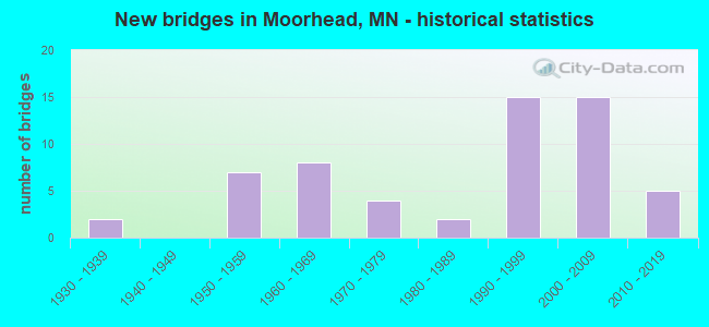
- New bridges - historical statistics
- 21930-1939
- 71950-1959
- 81960-1969
- 41970-1979
- 21980-1989
- 151990-1999
- 152000-2009
- 52010-2019

- Reconstructed bridges - Historical Statistics
- 21980-1989
- 01990-1999
- 12000-2009
- 12010-2019


- Bridge Condition - Deck
- 9.5%Very good
- 52.4%Good
- 23.8%Satisfactory
- 14.3%Fair

- Bridge Condition - Superstructure
- 19.0%Very good
- 47.6%Good
- 19.0%Satisfactory
- 14.3%Fair

- Bridge Condition - Substructure
- 9.5%Very good
- 38.1%Good
- 14.3%Satisfactory
- 38.1%Fair

- Bridge Condition - Channel
- 40.6%Very good
- 40.6%Good
- 12.5%Satisfactory
- 6.3%Fair

- Bridge Condition - Culverts
- 31.8%Very good
- 59.1%Good
- 9.1%Satisfactory
Find on map >> Show street view
Structure Number: 14012, Location: AT THE ND STATE LINE (Lat: 46.873839, Lng: -96.776069), Route carried "on" structure: US 10, Year Built: 2003, Status: Open, Structure Length: 24.59m (80.68ft), Average Daily Traffic: 22,443 (year 2019), Truck Traffic: 1%, Average Future Daily Traffic: 22,100 (year 2039), Design Load: HL 93, Features Intersected: RED R OF THE N; 3RD ST
Minimum Vertical Clearance: 30+ m (98+ ft), Kilometerpoint: 0.000, Lanes on structure: 4, Lanes under structure: 2, Base Highway Network: Yes, Owner: State Highway Agency, Approaching Roadway Width: 19.5m (64.0ft), Skew: 3 degrees, Material/Design: Steel continuous, Design/Construction: Stringer/Multi-beam, Number Of Spans In Main Unit: 5, Length of Maximum Span: 61.0m (200.1ft), Curb or Sidewalk Widths: Left: 3.0m (9.8ft), Right: 4.6m (15.1ft), Curb-To-Curb Width: 15.9m (52.2ft), Out-to-Out Width: 24.2m (79.4ft)
Condition: Deck: Satisfactory, Superstructure: Good, Substructure: Good, Channel: Good, Operating Rating: 54.2 metric tons, Method Used To Determine Operating Rating: Load Factor (LF), Inventory Rating: 32.5 metric tons, Method Used To Determine Inventory Rating: Load Factor (LF), Structural Evaluation: Better than present minimum criteria, Deck Geometry: Meets minimum limits, Underclear: Better than present minimum criteria, Waterway Adequacy: Equal to present desirable criteria, Approach Roadway Alignment: Equal to present desirable criteria, Designated Inspection Frequency: Every 24 months, Inspection Date: September 2021, Deck Structure Type: Concrete Cast-file-Place, Wearing Surface/Protective System: Wearing Surface: Low Slump Concrete, Deck Protection: Epoxy Coated Reinforcing
Find on map >> Show street view
Structure Number: 14511, Location: AT ND STATE LINE (Lat: 46.877006, Lng: -96.780144), Route carried "on" structure: City street 115, Year Built: 1981, Status: Open, Structure Length: 19.13m (62.76ft), Average Daily Traffic: 15,500 (year 2013), Average Future Daily Traffic: 15,500 (year 2039), Design Load: HS 20, Features Intersected: RED RIVER OF THE NORTH
Minimum Vertical Clearance: 30+ m (98+ ft), Kilometerpoint: 0.000, Lanes on structure: 4, Owner: City or Municipal Highway Agency, Approaching Roadway Width: 18.3m (60.0ft), Skew: 20 degrees, Material/Design: Steel continuous, Design/Construction: Stringer/Multi-beam, Number Of Spans In Main Unit: 2, Number Of Approach Spans: 5, Length of Maximum Span: 38.1m (125.0ft), Curb or Sidewalk Widths: Left: 3.7m (12.1ft), Right: 1.6m (5.2ft), Curb-To-Curb Width: 17.5m (57.4ft), Out-to-Out Width: 25.1m (82.3ft)
Condition: Deck: Good, Superstructure: Fair, Substructure: Good, Channel: Satisfactory, Operating Rating: 66.3 metric tons, Method Used To Determine Operating Rating: Load Factor (LF), Inventory Rating: 39.5 metric tons, Method Used To Determine Inventory Rating: Load Factor (LF), Structural Evaluation: Somewhat better than minimum adequacy, Deck Geometry: Somewhat better than minimum adequacy, Waterway Adequacy: Meets minimum limits, Approach Roadway Alignment: Equal to present desirable criteria, Designated Inspection Frequency: Every 24 months, Underwater Inspection Frequency: Every 60 months, Inspection Date: September 2021, Underwater Inspection Date: June 2021, Deck Structure Type: Concrete Cast-file-Place, Wearing Surface/Protective System: Wearing Surface: Low Slump Concrete, Deck Protection: Epoxy Coated Reinforcing
Find on map >> Show street view
Structure Number: 14523, Location: 0.5 MI W OF JCT CSAH 3 (Lat: 46.889778, Lng: -96.774222), Route carried "on" structure: City street 129, Year Built: 1988, Status: Open, Structure Length: 15.24m (50.00ft), Average Daily Traffic: 8,300 (year 2019), Truck Traffic: 2%, Average Future Daily Traffic: 8,800 (year 2039), Design Load: HS 20, Features Intersected: RED RIVER OF THE NORTH
Minimum Vertical Clearance: 30+ m (98+ ft), Kilometerpoint: 0.000, Lanes on structure: 2, Owner: City or Municipal Highway Agency, Approaching Roadway Width: 9.8m (32.2ft), Material/Design: Prestressed concrete, Design/Construction: Tee Beam, Number Of Spans In Main Unit: 5, Length of Maximum Span: 30.5m (100.1ft), Curb or Sidewalk Widths: Left: 0.0m, Right: 1.5m (4.9ft), Curb-To-Curb Width: 9.8m (32.2ft), Out-to-Out Width: 12.2m (40.0ft)
Condition: Deck: Good, Superstructure: Good, Substructure: Good, Channel: Satisfactory, Operating Rating: 49.3 metric tons, Method Used To Determine Operating Rating: Load Factor (LF), Inventory Rating: 29.6 metric tons, Method Used To Determine Inventory Rating: Load Factor (LF), Structural Evaluation: Better than present minimum criteria, Deck Geometry: Meets minimum limits, Waterway Adequacy: Meets minimum limits, Approach Roadway Alignment: Meets minimum limits, Length Of Structure Improvement: 4.63m (15.19ft), Designated Inspection Frequency: Every 24 months, Underwater Inspection Frequency: Every 60 months, Inspection Date: September 2021, Underwater Inspection Date: June 2021, Bridge Improvement Cost: $999,999,000, Roadway Improvement Cost: $143,000,000, Total Project Cost: $999,999,000, Deck Structure Type: Concrete Cast-file-Place, Wearing Surface/Protective System: Wearing Surface: Low Slump Concrete, Deck Protection: Epoxy Coated Reinforcing
Find on map >> Show street view
Structure Number: 1453, Location: 1.0 MI E OF JCT TH 75 (Lat: 46.847236, Lng: -96.747467), Route carried "on" structure: , Year Built: 1995, Year Reconstructed: 2015, Status: Open, Structure Length: 7.07m (23.20ft), Features Intersected: I 94, Facility Carried by Structure: PEDESTRIAN
Lanes under structure: 4, Owner: City or Municipal Highway Agency, Maintenance Responsibility: State Highway Agency, Material/Design: Prestressed concrete, Design/Construction: Stringer/Multi-beam, Number Of Spans In Main Unit: 2, Length of Maximum Span: 34.6m (113.5ft), Out-to-Out Width: 3.7m (12.1ft)
Condition: Deck: Very good, Superstructure: Very good, Substructure: Very good, Underclear: Equal to present minimum criteria, Bridge Posting: Required (Relationship of Operating Rating to Maximum Legal Load: > 39.9% below), Designated Inspection Frequency: Every 24 months, Inspection Date: September 2021, Deck Structure Type: Concrete Cast-file-Place, Wearing Surface/Protective System: Deck Protection: Epoxy Coated Reinforcing
Find on map >> Show street view
Structure Number: 14531, Location: 0.1 MI S OF JCT TH 10 (Lat: 46.874292, Lng: -96.725792), Route carried "on" structure: City street 135, Year Built: 1997, Status: Open, Structure Length: 31.09m (102.00ft), Average Daily Traffic: 15,600 (year 2017), Average Future Daily Traffic: 15,600 (year 2039), Design Load: HS 25 or greater, Features Intersected: BNSF RR; CD #4
Minimum Vertical Clearance: 30+ m (98+ ft), Kilometerpoint: 0.000, Lanes on structure: 4, Owner: City or Municipal Highway Agency, Approaching Roadway Width: 18.9m (62.0ft), Skew: 20 degrees, Material/Design: Steel continuous, Design/Construction: Stringer/Multi-beam, Number Of Spans In Main Unit: 8, Length of Maximum Span: 50.6m (166.0ft), Curb or Sidewalk Widths: Left: 3.0m (9.8ft), Right: 0.0m, Curb-To-Curb Width: 17.7m (58.1ft), Out-to-Out Width: 23.4m (76.8ft)
Condition: Deck: Good, Superstructure: Very good, Substructure: Satisfactory, Channel: Good, Operating Rating: 28.2 metric tons, Method Used To Determine Operating Rating: Load and Resistance Factor Rating (LRFR) rating reported by rating factor(RF) method using HL-93 loadings, Inventory Rating: 21.7 metric tons, Method Used To Determine Inventory Rating: Load and Resistance Factor Rating (LRFR) rating reported by rating factor(RF) method using HL-93 loadings, Structural Evaluation: Somewhat better than minimum adequacy, Deck Geometry: Somewhat better than minimum adequacy, Underclear: Better than present minimum criteria, Waterway Adequacy: Superior to present desirable criteria, Approach Roadway Alignment: Equal to present desirable criteria, Designated Inspection Frequency: Every 24 months, Inspection Date: September 2021, Deck Structure Type: Concrete Cast-file-Place, Wearing Surface/Protective System: Wearing Surface: Low Slump Concrete, Deck Protection: Epoxy Coated Reinforcing
Find on map >> Show street view
Structure Number: 14803, Location: 1.8 MI E OF JCT TH 336 (Lat: 46.834253, Lng: -96.621231), Route carried "on" structure: Interstate 94, Year Built: 1968, Status: Open, Structure Length: 15.72m (51.57ft), Average Daily Traffic: 10,550 (year 2019), Truck Traffic: 17%, Average Future Daily Traffic: 10,300 (year 2039), Design Load: HS 20, Features Intersected: S BR BUFFALO R
Minimum Vertical Clearance: 30+ m (98+ ft), Kilometerpoint: 0.000, Lanes on structure: 2, Base Highway Network: Yes, Owner: State Highway Agency, Approaching Roadway Width: 11.3m (37.1ft), Material/Design: Steel continuous, Design/Construction: Stringer/Multi-beam, Number Of Spans In Main Unit: 9, Length of Maximum Span: 23.8m (78.1ft), Curb-To-Curb Width: 12.2m (40.0ft), Out-to-Out Width: 13.2m (43.3ft)
Condition: Deck: Good, Superstructure: Good, Substructure: Good, Channel: Very good, Operating Rating: 57.1 metric tons, Method Used To Determine Operating Rating: Load Factor (LF), Inventory Rating: 34.5 metric tons, Method Used To Determine Inventory Rating: Load Factor (LF), Structural Evaluation: Better than present minimum criteria, Deck Geometry: Better than present minimum criteria, Waterway Adequacy: Equal to present desirable criteria, Approach Roadway Alignment: Equal to present desirable criteria, Designated Inspection Frequency: Every 24 months, Inspection Date: September 2021, Deck Structure Type: Concrete Cast-file-Place, Wearing Surface/Protective System: Wearing Surface: Monolithic Concrete, Deck Protection: Epoxy Coated Reinforcing
Find on map >> Show street view
Structure Number: 14804, Location: 1.8 MI E OF JCT TH 336 (Lat: 46.834114, Lng: -96.621483), Route carried "on" structure: Interstate 94, Year Built: 1968, Status: Open, Structure Length: 15.72m (51.57ft), Average Daily Traffic: 10,550 (year 2019), Truck Traffic: 15%, Average Future Daily Traffic: 10,300 (year 2039), Design Load: HS 20, Features Intersected: S BR BUFFALO R
Minimum Vertical Clearance: 30+ m (98+ ft), Kilometerpoint: 0.000, Lanes on structure: 2, Base Highway Network: Yes, Owner: State Highway Agency, Approaching Roadway Width: 11.6m (38.1ft), Material/Design: Steel continuous, Design/Construction: Stringer/Multi-beam, Number Of Spans In Main Unit: 9, Length of Maximum Span: 23.8m (78.1ft), Curb-To-Curb Width: 12.2m (40.0ft), Out-to-Out Width: 13.2m (43.3ft)
Condition: Deck: Satisfactory, Superstructure: Good, Substructure: Good, Channel: Very good, Operating Rating: 57.5 metric tons, Method Used To Determine Operating Rating: Load Factor (LF), Inventory Rating: 34.6 metric tons, Method Used To Determine Inventory Rating: Load Factor (LF), Structural Evaluation: Better than present minimum criteria, Deck Geometry: Better than present minimum criteria, Waterway Adequacy: Equal to present desirable criteria, Approach Roadway Alignment: Equal to present desirable criteria, Designated Inspection Frequency: Every 24 months, Inspection Date: September 2021, Deck Structure Type: Concrete Cast-file-Place, Wearing Surface/Protective System: Wearing Surface: Monolithic Concrete, Deck Protection: Epoxy Coated Reinforcing
Find on map >> Show street view
Structure Number: 14811, Location: 1.0 MI E OF JCT TH 75 (Lat: 46.847267, Lng: -96.747719), Route carried "on" structure: City street 126, Year Built: 1973, Status: Open, Structure Length: 7.06m (23.16ft), Average Daily Traffic: 11,600 (year 2017), Average Future Daily Traffic: 11,600 (year 2039), Design Load: HS 20, Features Intersected: I 94
Minimum Vertical Clearance: 30+ m (98+ ft), Kilometerpoint: 0.000, Lanes on structure: 3, Lanes under structure: 4, Owner: State Highway Agency, Approaching Roadway Width: 15.2m (49.9ft), Material/Design: Prestressed concrete, Design/Construction: Stringer/Multi-beam, Number Of Spans In Main Unit: 4, Length of Maximum Span: 21.8m (71.5ft), Curb or Sidewalk Widths: Left: 1.8m (5.9ft), Right: 0.0m, Curb-To-Curb Width: 15.2m (49.9ft), Out-to-Out Width: 18.0m (59.1ft)
Condition: Deck: Good, Superstructure: Very good, Substructure: Good, Operating Rating: 62.0 metric tons, Method Used To Determine Operating Rating: Load Factor (LF), Inventory Rating: 27.4 metric tons, Method Used To Determine Inventory Rating: Load Factor (LF), Structural Evaluation: Equal to present minimum criteria, Deck Geometry: Equal to present minimum criteria, Underclear: Somewhat better than minimum adequacy, Approach Roadway Alignment: Equal to present desirable criteria, Length Of Structure Improvement: 2.38m (7.81ft), Designated Inspection Frequency: Every 24 months, Inspection Date: September 2021, Bridge Improvement Cost: $999,999,000, Deck Structure Type: Concrete Cast-file-Place, Wearing Surface/Protective System: Wearing Surface: Low Slump Concrete
Find on map >> Show street view
Structure Number: 14813, Location: AT THE JCT TH 75 IN MOOR (Lat: 46.847078, Lng: -96.768228), Route carried "on" structure: US 75, Year Built: 2000, Status: Open, Structure Length: 5.61m (18.41ft), Average Daily Traffic: 16,756 (year 2019), Truck Traffic: 4%, Average Future Daily Traffic: 16,500 (year 2039), Design Load: HS 25 or greater, Features Intersected: I 94
Minimum Vertical Clearance: 30+ m (98+ ft), Kilometerpoint: 0.000, Lanes on structure: 2, Lanes under structure: 4, Base Highway Network: Yes, Owner: State Highway Agency, Approaching Roadway Width: 14.6m (47.9ft), Material/Design: Prestressed concrete, Design/Construction: Stringer/Multi-beam, Number Of Spans In Main Unit: 2, Length of Maximum Span: 27.3m (89.6ft), Curb-To-Curb Width: 15.2m (49.9ft), Out-to-Out Width: 16.2m (53.1ft)
Condition: Deck: Good, Superstructure: Good, Substructure: Fair, Operating Rating: 71.7 metric tons, Method Used To Determine Operating Rating: Load Factor (LF), Inventory Rating: 39.9 metric tons, Method Used To Determine Inventory Rating: Load Factor (LF), Structural Evaluation: Somewhat better than minimum adequacy, Deck Geometry: Superior to present desirable criteria, Underclear: Equal to present minimum criteria, Approach Roadway Alignment: Better than present minimum criteria, Designated Inspection Frequency: Every 24 months, Inspection Date: August 2021, Deck Structure Type: Concrete Cast-file-Place, Wearing Surface/Protective System: Wearing Surface: Low Slump Concrete, Deck Protection: Epoxy Coated Reinforcing
Find on map >> Show street view
Structure Number: 14814, Location: AT THE JCT TH 75 IN MOOR (Lat: 46.847047, Lng: -96.767936), Route carried "on" structure: US 75, Year Built: 2000, Year Reconstructed: 2008, Status: Open, Structure Length: 5.61m (18.41ft), Average Daily Traffic: 16,500 (year 2015), Truck Traffic: 3%, Average Future Daily Traffic: 16,500 (year 2039), Design Load: HS 25 or greater, Features Intersected: I 94
Minimum Vertical Clearance: 30+ m (98+ ft), Kilometerpoint: 0.000, Lanes on structure: 2, Lanes under structure: 4, Base Highway Network: Yes, Owner: State Highway Agency, Approaching Roadway Width: 14.6m (47.9ft), Material/Design: Prestressed concrete, Design/Construction: Stringer/Multi-beam, Number Of Spans In Main Unit: 2, Length of Maximum Span: 27.3m (89.6ft), Curb-To-Curb Width: 15.2m (49.9ft), Out-to-Out Width: 19.5m (64.0ft)
Condition: Deck: Good, Superstructure: Good, Substructure: Fair, Operating Rating: 78.0 metric tons, Method Used To Determine Operating Rating: Load Factor (LF), Inventory Rating: 43.5 metric tons, Method Used To Determine Inventory Rating: Load Factor (LF), Structural Evaluation: Somewhat better than minimum adequacy, Deck Geometry: Superior to present desirable criteria, Underclear: Somewhat better than minimum adequacy, Approach Roadway Alignment: Better than present minimum criteria, Designated Inspection Frequency: Every 24 months, Inspection Date: August 2021, Deck Structure Type: Concrete Cast-file-Place, Wearing Surface/Protective System: Wearing Surface: Low Slump Concrete, Deck Protection: Epoxy Coated Reinforcing
Find on map >> Show street view
Structure Number: 14815, Location: at the jct TH 94; TH 336 (Lat: 46.846181, Lng: -96.652211), Route carried "on" structure: State highway 336, Year Built: 2002, Status: Open, Structure Length: 7.31m (23.98ft), Average Daily Traffic: 14,000 (year 2019), Truck Traffic: 12%, Average Future Daily Traffic: 12,700 (year 2039), Design Load: HS 25 or greater, Features Intersected: ISTH 94
Minimum Vertical Clearance: 30+ m (98+ ft), Kilometerpoint: 0.000, Lanes on structure: 4, Lanes under structure: 5, Base Highway Network: Yes, Owner: State Highway Agency, Approaching Roadway Width: 24.4m (80.1ft), Skew: 20 degrees, Material/Design: Prestressed concrete, Design/Construction: Stringer/Multi-beam, Number Of Spans In Main Unit: 2, Length of Maximum Span: 39.6m (129.9ft), Curb-To-Curb Width: 25.6m (84.0ft), Out-to-Out Width: 30.9m (101.4ft)
Condition: Deck: Good, Superstructure: Good, Substructure: Fair, Operating Rating: 90.4 metric tons, Method Used To Determine Operating Rating: Load Factor (LF), Inventory Rating: 55.1 metric tons, Method Used To Determine Inventory Rating: Load Factor (LF), Structural Evaluation: Somewhat better than minimum adequacy, Deck Geometry: Superior to present desirable criteria, Underclear: Equal to present minimum criteria, Approach Roadway Alignment: Equal to present desirable criteria, Designated Inspection Frequency: Every 24 months, Inspection Date: September 2021, Deck Structure Type: Concrete Cast-file-Place, Wearing Surface/Protective System: Wearing Surface: Low Slump Concrete, Deck Protection: Epoxy Coated Reinforcing
Find on map >> Show street view
Structure Number: 14816, Location: 0.1 MI E OF JCT MAIN; 94 (Lat: 46.847333, Lng: -96.720694), Route carried "on" structure: City street 135, Year Built: 2010, Status: Open, Structure Length: 10.99m (36.06ft), Average Daily Traffic: 10,800 (year 2017), Average Future Daily Traffic: 10,800 (year 2039), Design Load: HL 93, Features Intersected: I 94
Minimum Vertical Clearance: 30+ m (98+ ft), Kilometerpoint: 0.000, Lanes on structure: 5, Lanes under structure: 4, Owner: State Highway Agency, Approaching Roadway Width: 18.9m (62.0ft), Skew: 20 degrees, Material/Design: Prestressed concrete, Design/Construction: Stringer/Multi-beam, Number Of Spans In Main Unit: 3, Length of Maximum Span: 40.5m (132.9ft), Curb or Sidewalk Widths: Left: 3.7m (12.1ft), Right: 0.0m, Curb-To-Curb Width: 21.3m (69.9ft), Out-to-Out Width: 31.3m (102.7ft)
Condition: Deck: Satisfactory, Superstructure: Good, Substructure: Fair, Operating Rating: 52.2 metric tons, Method Used To Determine Operating Rating: Load and Resistance Factor Rating (LRFR) rating reported by rating factor(RF) method using HL-93 loadings, Inventory Rating: 40.2 metric tons, Method Used To Determine Inventory Rating: Load and Resistance Factor Rating (LRFR) rating reported by rating factor(RF) method using HL-93 loadings, Structural Evaluation: Somewhat better than minimum adequacy, Deck Geometry: Somewhat better than minimum adequacy, Underclear: Equal to present minimum criteria, Approach Roadway Alignment: Equal to present desirable criteria, Designated Inspection Frequency: Every 24 months, Inspection Date: October 2021, Deck Structure Type: Concrete Cast-file-Place, Wearing Surface/Protective System: Wearing Surface: Low Slump Concrete, Deck Protection: Epoxy Coated Reinforcing
Find on map >> Show street view
Structure Number: 14J3, Location: .01 M E OF 28TH ST N (Lat: 46.875325, Lng: -96.736106), Route carried "on" structure: City street 222, Year Built: 1996, Status: Open, Structure Length: 0.83m (2.72ft), Average Daily Traffic: 1 (year 2009), Average Future Daily Traffic: 1 (year 2029), Design Load: HS 25 or greater, Features Intersected: CO DITCH # 41
Minimum Vertical Clearance: 30+ m (98+ ft), Kilometerpoint: 0.000, Lanes on structure: 2, Owner: City or Municipal Highway Agency, Approaching Roadway Width: 8.5m (27.9ft), Material/Design: Concrete, Design/Construction: Culvert, Number Of Spans In Main Unit: 2, Length of Maximum Span: 3.7m (12.1ft)
Condition: Channel: Very good, Culverts: Good, Operating Rating: 68.6 metric tons, Method Used To Determine Operating Rating: Assigned rating based on Load Factor Design (LFD) reported in metric tons, Inventory Rating: 40.8 metric tons, Method Used To Determine Inventory Rating: Assigned rating based on Load Factor Design (LFD) reported in metric tons, Structural Evaluation: Better than present minimum criteria, Waterway Adequacy: Equal to present desirable criteria, Approach Roadway Alignment: Equal to present desirable criteria, Designated Inspection Frequency: Every 48 months, Inspection Date: September 2019
Find on map >> Show street view
Structure Number: 14J52, Location: 0.1 MI E OF JCT CSAH 52 (Lat: 46.842022, Lng: -96.716719), Route carried "on" structure: City street 135, Year Built: 2003, Status: Open, Structure Length: 0.78m (2.56ft), Average Daily Traffic: 6,600 (year 2017), Average Future Daily Traffic: 6,600 (year 2039), Design Load: HS 25 or greater, Features Intersected: CO DITCH # 47
Minimum Vertical Clearance: 30+ m (98+ ft), Kilometerpoint: 0.000, Lanes on structure: 2, Owner: City or Municipal Highway Agency, Approaching Roadway Width: 16.5m (54.1ft), Material/Design: Concrete, Design/Construction: Culvert, Number Of Spans In Main Unit: 2, Length of Maximum Span: 3.0m (9.8ft)
Condition: Channel: Good, Culverts: Good, Operating Rating: 68.6 metric tons, Method Used To Determine Operating Rating: Assigned rating based on Load Factor Design (LFD) reported in metric tons, Inventory Rating: 40.8 metric tons, Method Used To Determine Inventory Rating: Assigned rating based on Load Factor Design (LFD) reported in metric tons, Structural Evaluation: Better than present minimum criteria, Waterway Adequacy: Equal to present desirable criteria, Approach Roadway Alignment: Equal to present desirable criteria, Length Of Structure Improvement: 0.37m (1.21ft), Designated Inspection Frequency: Every 48 months, Inspection Date: September 2019, Bridge Improvement Cost: $74,000,000, Roadway Improvement Cost: $1,000, Total Project Cost: $1,000
Find on map >> Show street view
Structure Number: 14J67, Location: 0.1 MI E OF JCT CSAH 52 (Lat: 46.833214, Lng: -96.707322), Route carried "on" structure: County highway 76, Year Built: 2004, Status: Open, Structure Length: 1.11m (3.64ft), Average Daily Traffic: 145 (year 2017), Average Future Daily Traffic: 145 (year 2039), Design Load: HS 25 or greater, Features Intersected: CNTY DITCH # 47
Minimum Vertical Clearance: 30+ m (98+ ft), Kilometerpoint: 0.000, Lanes on structure: 2, Owner: County Highway Agency, Approaching Roadway Width: 8.5m (27.9ft), Skew: 5 degrees, Material/Design: Concrete, Design/Construction: Culvert, Number Of Spans In Main Unit: 2, Length of Maximum Span: 4.1m (13.5ft)
Condition: Channel: Very good, Culverts: Very good, Operating Rating: 58.8 metric tons, Method Used To Determine Operating Rating: Assigned rating based on Load Factor Design (LFD) reported in metric tons, Inventory Rating: 39.2 metric tons, Method Used To Determine Inventory Rating: Assigned rating based on Load Factor Design (LFD) reported in metric tons, Structural Evaluation: Equal to present desirable criteria, Waterway Adequacy: Equal to present desirable criteria, Approach Roadway Alignment: Equal to present desirable criteria, Designated Inspection Frequency: Every 48 months, Inspection Date: August 2020
Find on map >> Show street view
Structure Number: 14J86, Location: 0.1 MI E OF MAIN ST (Lat: 46.852567, Lng: -96.727989), Route carried "on" structure: City street 140, Year Built: 2010, Status: Open, Structure Length: 0.83m (2.72ft), Average Daily Traffic: 4,450 (year 2017), Average Future Daily Traffic: 4,450 (year 2039), Design Load: HS 25 or greater, Features Intersected: COUNTY DITCH #47
Minimum Vertical Clearance: 30+ m (98+ ft), Kilometerpoint: 0.000, Lanes on structure: 4, Owner: City or Municipal Highway Agency, Approaching Roadway Width: 18.0m (59.1ft), Skew: 20 degrees, Material/Design: Concrete, Design/Construction: Culvert, Number Of Spans In Main Unit: 2, Length of Maximum Span: 3.7m (12.1ft)
Condition: Channel: Good, Culverts: Good, Operating Rating: 68.6 metric tons, Method Used To Determine Operating Rating: Assigned rating based on Load Factor Design (LFD) reported in metric tons, Inventory Rating: 40.8 metric tons, Method Used To Determine Inventory Rating: Assigned rating based on Load Factor Design (LFD) reported in metric tons, Structural Evaluation: Better than present minimum criteria, Waterway Adequacy: Superior to present desirable criteria, Approach Roadway Alignment: Equal to present desirable criteria, Designated Inspection Frequency: Every 24 months, Inspection Date: June 2021
Find on map >> Show street view
Structure Number: 14J97, Location: 0.03 MI NE JCT CSAH 52 (Lat: 46.837789, Lng: -96.712231), Route carried "on" structure: City street 475, Year Built: 2004, Status: Open, Structure Length: 0.96m (3.15ft), Average Daily Traffic: 1 (year 2009), Average Future Daily Traffic: 1 (year 2029), Design Load: HS 25 or greater, Features Intersected: CD #47
Minimum Vertical Clearance: 30+ m (98+ ft), Kilometerpoint: 0.000, Lanes on structure: 2, Owner: City or Municipal Highway Agency, Approaching Roadway Width: 7.3m (24.0ft), Skew: 30 degrees, Material/Design: Concrete, Design/Construction: Culvert, Number Of Spans In Main Unit: 2, Length of Maximum Span: 4.3m (14.1ft)
Condition: Channel: Satisfactory, Culverts: Good, Operating Rating: 58.8 metric tons, Method Used To Determine Operating Rating: Assigned rating based on Load Factor Design (LFD) reported in metric tons, Inventory Rating: 39.2 metric tons, Method Used To Determine Inventory Rating: Assigned rating based on Load Factor Design (LFD) reported in metric tons, Structural Evaluation: Better than present minimum criteria, Waterway Adequacy: Equal to present desirable criteria, Approach Roadway Alignment: Equal to present desirable criteria, Designated Inspection Frequency: Every 24 months, Inspection Date: August 2021
Find on map >> Show street view
Structure Number: 14K08, Location: 0.3 MI NW OF JCT CSAH 52 (Lat: 46.844703, Lng: -96.718444), Route carried "on" structure: City street 135, Year Built: 2009, Status: Open, Structure Length: 0.73m (2.40ft), Average Daily Traffic: 6,600 (year 2017), Average Future Daily Traffic: 6,600 (year 2039), Design Load: HS 25 or greater, Features Intersected: COUNTY DITCH #47
Minimum Vertical Clearance: 30+ m (98+ ft), Kilometerpoint: 0.000, Lanes on structure: 4, Owner: City or Municipal Highway Agency, Approaching Roadway Width: 17.7m (58.1ft), Skew: 21 degrees, Material/Design: Concrete, Design/Construction: Culvert, Number Of Spans In Main Unit: 2, Length of Maximum Span: 3.0m (9.8ft)
Condition: Channel: Good, Culverts: Good, Operating Rating: 68.6 metric tons, Method Used To Determine Operating Rating: Assigned rating based on Load Factor Design (LFD) reported in metric tons, Inventory Rating: 40.8 metric tons, Method Used To Determine Inventory Rating: Assigned rating based on Load Factor Design (LFD) reported in metric tons, Structural Evaluation: Better than present minimum criteria, Waterway Adequacy: Superior to present desirable criteria, Approach Roadway Alignment: Equal to present desirable criteria, Designated Inspection Frequency: Every 24 months, Inspection Date: June 2021
Find on map >> Show street view
Structure Number: 14K1, Location: 0.1 MI S OF JCT CR 67 (Lat: 46.774833, Lng: -96.736319), Route carried "on" structure: County highway 329, Year Built: 2008, Status: Open, Structure Length: 0.73m (2.40ft), Average Daily Traffic: 20 (year 2017), Average Future Daily Traffic: 20 (year 2039), Design Load: HS 25 or greater, Features Intersected: CO DITCH #32
Minimum Vertical Clearance: 30+ m (98+ ft), Kilometerpoint: 0.000, Lanes on structure: 2, Owner: Town or Township Highway Agency, Approaching Roadway Width: 7.3m (24.0ft), Material/Design: Concrete, Design/Construction: Culvert, Number Of Spans In Main Unit: 2, Length of Maximum Span: 3.1m (10.2ft)
Condition: Channel: Very good, Culverts: Very good, Operating Rating: 68.6 metric tons, Method Used To Determine Operating Rating: Assigned ratings based on Allowable Stress Design (ASD) reported in metric tons, Inventory Rating: 40.8 metric tons, Method Used To Determine Inventory Rating: Assigned ratings based on Allowable Stress Design (ASD) reported in metric tons, Structural Evaluation: Equal to present desirable criteria, Waterway Adequacy: Equal to present desirable criteria, Approach Roadway Alignment: Equal to present desirable criteria, Designated Inspection Frequency: Every 24 months, Inspection Date: August 2021
Find on map >> Show street view
Structure Number: 14K14, Location: 0.2 MI W OF JCT US 75 (Lat: 46.884353, Lng: -96.741378), Route carried "on" structure: City street 139, Year Built: 2008, Status: Open, Structure Length: 0.98m (3.22ft), Average Daily Traffic: 1 (year 2018), Average Future Daily Traffic: 1 (year 2038), Design Load: HS 25 or greater, Features Intersected: COUNTY DITCH 41
Minimum Vertical Clearance: 30+ m (98+ ft), Kilometerpoint: 0.000, Lanes on structure: 2, Owner: City or Municipal Highway Agency, Approaching Roadway Width: 15.2m (49.9ft), Skew: 10 degrees, Material/Design: Concrete, Design/Construction: Culvert, Number Of Spans In Main Unit: 2, Length of Maximum Span: 4.3m (14.1ft)
Condition: Channel: Good, Culverts: Good, Operating Rating: 58.8 metric tons, Method Used To Determine Operating Rating: Assigned rating based on Load Factor Design (LFD) reported in metric tons, Inventory Rating: 39.2 metric tons, Method Used To Determine Inventory Rating: Assigned rating based on Load Factor Design (LFD) reported in metric tons, Structural Evaluation: Better than present minimum criteria, Waterway Adequacy: Superior to present desirable criteria, Approach Roadway Alignment: Better than present minimum criteria, Designated Inspection Frequency: Every 24 months, Inspection Date: June 2021
Find on map >> Show street view
Structure Number: 14X01, Location: WEIGH SCALE EB ON RAMP (Lat: 46.846756, Lng: -96.672539), Route carried "on" structure: Ramp Interstate 6826, Year Built: 1995, Status: Open, Structure Length: 0.70m (2.30ft), Average Daily Traffic: 1 (year 2009), Average Future Daily Traffic: 1 (year 2029), Design Load: HS 25 or greater, Features Intersected: CO DITCH #4
Minimum Vertical Clearance: 30+ m (98+ ft), Kilometerpoint: 0.000, Lanes on structure: 1, Owner: State Highway Agency, Approaching Roadway Width: 10.4m (34.1ft), Material/Design: Concrete, Design/Construction: Culvert, Number Of Spans In Main Unit: 2, Length of Maximum Span: 3.1m (10.2ft)
Condition: Channel: Good, Culverts: Very good, Operating Rating: 53.9 metric tons, Method Used To Determine Operating Rating: Assigned ratings based on Allowable Stress Design (ASD) reported in metric tons, Inventory Rating: 35.9 metric tons, Method Used To Determine Inventory Rating: Assigned ratings based on Allowable Stress Design (ASD) reported in metric tons, Structural Evaluation: Equal to present desirable criteria, Waterway Adequacy: Equal to present desirable criteria, Approach Roadway Alignment: Equal to present desirable criteria, Designated Inspection Frequency: Every 48 months, Inspection Date: August 2021
Find on map >> Show street view
Structure Number: 14X02, Location: 0.4 MI E OF E JCT TH 75 (Lat: 46.876311, Lng: -96.736083), Route carried "on" structure: US 10, Year Built: 1997, Status: Open, Structure Length: 0.91m (2.99ft), Average Daily Traffic: 17,900 (year 2019), Truck Traffic: 5%, Average Future Daily Traffic: 20,400 (year 2039), Design Load: HS 25 or greater, Features Intersected: CO DITCH # 41
Minimum Vertical Clearance: 30+ m (98+ ft), Kilometerpoint: 0.000, Lanes on structure: 4, Base Highway Network: Yes, Owner: State Highway Agency, Approaching Roadway Width: 38.4m (126.0ft), Skew: 10 degrees, Material/Design: Concrete, Design/Construction: Culvert, Number Of Spans In Main Unit: 2, Length of Maximum Span: 3.7m (12.1ft)
Condition: Channel: Very good, Culverts: Very good, Operating Rating: 68.6 metric tons, Method Used To Determine Operating Rating: Assigned rating based on Load Factor Design (LFD) reported in metric tons, Inventory Rating: 40.8 metric tons, Method Used To Determine Inventory Rating: Assigned rating based on Load Factor Design (LFD) reported in metric tons, Structural Evaluation: Equal to present desirable criteria, Waterway Adequacy: Equal to present desirable criteria, Approach Roadway Alignment: Equal to present desirable criteria, Designated Inspection Frequency: Every 48 months, Inspection Date: August 2021
Find on map >> Show street view
Structure Number: 14X05, Location: 2.1 MI E OF JCT TH 75 (Lat: 46.847222, Lng: -96.717064), Route carried "on" structure: Interstate 94, Year Built: 2003, Status: Open, Structure Length: 0.87m (2.85ft), Average Daily Traffic: 36,000 (year 2019), Truck Traffic: 11%, Average Future Daily Traffic: 39,800 (year 2039), Design Load: HS 25 or greater, Features Intersected: CO DITCH # 47
Minimum Vertical Clearance: 30+ m (98+ ft), Kilometerpoint: 0.000, Lanes on structure: 4, Base Highway Network: Yes, Owner: State Highway Agency, Approaching Roadway Width: 22.6m (74.1ft), Material/Design: Concrete, Design/Construction: Culvert, Number Of Spans In Main Unit: 2, Length of Maximum Span: 3.7m (12.1ft)
Condition: Channel: Good, Culverts: Very good, Operating Rating: 68.6 metric tons, Method Used To Determine Operating Rating: Assigned rating based on Load Factor Design (LFD) reported in metric tons, Inventory Rating: 40.8 metric tons, Method Used To Determine Inventory Rating: Assigned rating based on Load Factor Design (LFD) reported in metric tons, Structural Evaluation: Equal to present desirable criteria, Waterway Adequacy: Equal to present desirable criteria, Approach Roadway Alignment: Equal to present desirable criteria, Designated Inspection Frequency: Every 48 months, Inspection Date: August 2021
Find on map >> Show street view
Structure Number: 14X06, Location: AT JCT 34TH ST S; I 94 (Lat: 46.848319, Lng: -96.718606), Route carried "on" structure: Ramp Interstate 6818, Year Built: 2010, Status: Open, Structure Length: 0.83m (2.72ft), Average Daily Traffic: 1 (year 2010), Average Future Daily Traffic: 1 (year 2032), Design Load: HS 25 or greater, Features Intersected: CO DITCH #47 N
Minimum Vertical Clearance: 30+ m (98+ ft), Kilometerpoint: 0.000, Lanes on structure: 1, Base Highway Network: Yes, Owner: State Highway Agency, Approaching Roadway Width: 3.7m (12.1ft), Material/Design: Concrete, Design/Construction: Culvert, Number Of Spans In Main Unit: 2, Length of Maximum Span: 3.7m (12.1ft)
Condition: Channel: Very good, Culverts: Good, Operating Rating: 68.6 metric tons, Method Used To Determine Operating Rating: Assigned rating based on Load Factor Design (LFD) reported in metric tons, Inventory Rating: 40.8 metric tons, Method Used To Determine Inventory Rating: Assigned rating based on Load Factor Design (LFD) reported in metric tons, Structural Evaluation: Better than present minimum criteria, Waterway Adequacy: Superior to present desirable criteria, Approach Roadway Alignment: Better than present minimum criteria, Designated Inspection Frequency: Every 48 months, Inspection Date: July 2021
Find on map >> Show street view
Structure Number: 14X07, Location: AT JCT 34TH ST S; I 94 (Lat: 46.846050, Lng: -96.717353), Route carried "on" structure: Ramp Interstate 6821, Year Built: 2010, Status: Open, Structure Length: 0.83m (2.72ft), Average Daily Traffic: 1 (year 2010), Average Future Daily Traffic: 1 (year 2032), Design Load: HS 25 or greater, Features Intersected: CO DITCH #47 S
Minimum Vertical Clearance: 30+ m (98+ ft), Kilometerpoint: 0.000, Lanes on structure: 1, Base Highway Network: Yes, Owner: State Highway Agency, Approaching Roadway Width: 3.7m (12.1ft), Material/Design: Concrete, Design/Construction: Culvert, Number Of Spans In Main Unit: 2, Length of Maximum Span: 3.7m (12.1ft)
Condition: Channel: Very good, Culverts: Good, Operating Rating: 68.6 metric tons, Method Used To Determine Operating Rating: Assigned rating based on Load Factor Design (LFD) reported in metric tons, Inventory Rating: 40.8 metric tons, Method Used To Determine Inventory Rating: Assigned rating based on Load Factor Design (LFD) reported in metric tons, Structural Evaluation: Better than present minimum criteria, Waterway Adequacy: Equal to present desirable criteria, Approach Roadway Alignment: Better than present minimum criteria, Designated Inspection Frequency: Every 48 months, Inspection Date: August 2021
Find on map >> Show street view
Structure Number: 527, Location: AT NO DAKOTA STATE LINE (Lat: 46.875072, Lng: -96.776328), Route carried "on" structure: City street 130, Year Built: 1937, Year Reconstructed: 1986, Status: Open, Structure Length: 26.08m (85.56ft), Average Daily Traffic: 6,200 (year 2017), Average Future Daily Traffic: 6,200 (year 2039), Design Load: HS 20, Features Intersected: RED RIVER; 3RD ST
Minimum Vertical Clearance: 30+ m (98+ ft), Kilometerpoint: 0.000, Lanes on structure: 4, Lanes under structure: 2, Owner: City or Municipal Highway Agency, Approaching Roadway Width: 17.1m (56.1ft), Skew: 3 degrees, Material/Design: Steel continuous, Design/Construction: Stringer/Multi-beam, Number Of Spans In Main Unit: 13, Length of Maximum Span: 30.5m (100.1ft), Curb or Sidewalk Widths: Left: 1.6m (5.2ft), Right: 0.0m, Curb-To-Curb Width: 14.6m (47.9ft), Out-to-Out Width: 17.0m (55.8ft)
Condition: Deck: Fair, Superstructure: Fair, Substructure: Satisfactory, Channel: Fair, Operating Rating: 35.3 metric tons, Method Used To Determine Operating Rating: Load Factor (LF), Inventory Rating: 20.9 metric tons, Method Used To Determine Inventory Rating: Load Factor (LF), Structural Evaluation: Somewhat better than minimum adequacy, Deck Geometry: High priority of replacement, Underclear: Meets minimum limits, Waterway Adequacy: Equal to present desirable criteria, Approach Roadway Alignment: Better than present minimum criteria, Length Of Structure Improvement: 7.96m (26.12ft), Designated Inspection Frequency: Every 24 months, Underwater Inspection Frequency: Every 60 months, Other Special Inspection Frequency: Every 60 months, Inspection Date: September 2021, Underwater Inspection Date: June 2021, Other Special Inspection Date: May 2021, Bridge Improvement Cost: $999,999,000, Roadway Improvement Cost: $26,000,000, Total Project Cost: $291,000,000, Deck Structure Type: Concrete Cast-file-Place, Wearing Surface/Protective System: Wearing Surface: Monolithic Concrete, Deck Protection: Epoxy Coated Reinforcing
Find on map >> Show street view
Structure Number: 6397, Location: IN MOORHEAD (Lat: 46.888681, Lng: -96.746222), Route carried "on" structure: US 75, Year Built: 1951, Status: Open, Structure Length: 0.81m (2.66ft), Average Daily Traffic: 6,700 (year 2019), Truck Traffic: 12%, Average Future Daily Traffic: 7,200 (year 2039), Design Load: H 20, Features Intersected: CO DITCH # 41
Minimum Vertical Clearance: 30+ m (98+ ft), Kilometerpoint: 0.000, Lanes on structure: 2, Owner: State Highway Agency, Approaching Roadway Width: 12.8m (42.0ft), Skew: 3 degrees, Material/Design: Concrete, Design/Construction: Culvert, Number Of Spans In Main Unit: 2, Length of Maximum Span: 3.5m (11.5ft)
Condition: Channel: Good, Culverts: Satisfactory, Operating Rating: 39.2 metric tons, Method Used To Determine Operating Rating: Assigned ratings based on Allowable Stress Design (ASD) reported in metric tons, Inventory Rating: 29.4 metric tons, Method Used To Determine Inventory Rating: Assigned ratings based on Allowable Stress Design (ASD) reported in metric tons, Structural Evaluation: Equal to present minimum criteria, Waterway Adequacy: Equal to present desirable criteria, Approach Roadway Alignment: Equal to present desirable criteria, Designated Inspection Frequency: Every 24 months, Inspection Date: September 2021
Find on map >> Show street view
Structure Number: 6408, Location: IN MOORHEAD (Lat: 46.874772, Lng: -96.753783), Route carried "on" structure: , Year Built: 1953, Status: Open, Structure Length: 5.90m (19.36ft), Features Intersected: US 10, Facility Carried by Structure: RAILROAD
Lanes under structure: 4, Owner: Railroad, Skew: 5 degrees, Material/Design: Steel, Design/Construction: Girder and Floorbeam System, Number Of Spans In Main Unit: 4, Length of Maximum Span: 24.5m (80.4ft), Curb or Sidewalk Widths: Left: 1.2m (3.9ft), Right: 1.2m (3.9ft), Out-to-Out Width: 6.4m (21.0ft)
Condition: Deck: Good, Superstructure: Fair, Substructure: Fair, Underclear: High priority of corrective action, Bridge Posting: Required (Relationship of Operating Rating to Maximum Legal Load: > 39.9% below), Length Of Structure Improvement: 1.98m (6.50ft), Designated Inspection Frequency: Every 12 months, Inspection Date: August 2021, Bridge Improvement Cost: $999,999,000
Find on map >> Show street view
Structure Number: 9066, Location: 0.6 MI W OF JCT TH 75 (Lat: 46.847806, Lng: -96.780372), Route carried "on" structure: Interstate 94, Year Built: 1958, Year Reconstructed: 1992, Status: Open, Structure Length: 39.60m (129.92ft), Average Daily Traffic: 37,000 (year 2017), Truck Traffic: 8%, Average Future Daily Traffic: 37,000 (year 2039), Design Load: HS 25 or greater, Features Intersected: RED RIVER;STR
Minimum Vertical Clearance: 30+ m (98+ ft), Kilometerpoint: 0.000, Lanes on structure: 3, Lanes under structure: 2, Base Highway Network: Yes, Owner: State Highway Agency, Approaching Roadway Width: 17.1m (56.1ft), Material/Design: Steel continuous, Design/Construction: Stringer/Multi-beam, Number Of Spans In Main Unit: 4, Number Of Approach Spans: 13, Length of Maximum Span: 36.9m (121.1ft), Curb-To-Curb Width: 17.1m (56.1ft), Out-to-Out Width: 17.8m (58.4ft)
Condition: Deck: Fair, Superstructure: Satisfactory, Substructure: Fair, Channel: Good, Operating Rating: 67.9 metric tons, Method Used To Determine Operating Rating: Load Factor (LF), Inventory Rating: 40.6 metric tons, Method Used To Determine Inventory Rating: Load Factor (LF), Structural Evaluation: Somewhat better than minimum adequacy, Deck Geometry: Equal to present minimum criteria, Underclear: Meets minimum limits, Waterway Adequacy: Equal to present desirable criteria, Approach Roadway Alignment: Equal to present desirable criteria, Length Of Structure Improvement: 12.07m (39.60ft), Designated Inspection Frequency: Every 24 months, Underwater Inspection Frequency: Every 60 months, Inspection Date: September 2021, Underwater Inspection Date: June 2021, Bridge Improvement Cost: $999,999,000, Total Project Cost: $999,999,000, Deck Structure Type: Concrete Cast-file-Place, Wearing Surface/Protective System: Wearing Surface: Epoxy Overlay, Deck Protection: Epoxy Coated Reinforcing
Find on map >> Show street view
Structure Number: 9067, Location: 0.6 MI W OF JCT TH 75 (Lat: 46.847633, Lng: -96.780556), Route carried "on" structure: Interstate 94, Year Built: 1958, Status: Open, Structure Length: 39.62m (129.99ft), Average Daily Traffic: 35,000 (year 2019), Truck Traffic: 9%, Average Future Daily Traffic: 37,000 (year 2039), Design Load: HS 25 or greater, Features Intersected: RED RIVER;STR
Minimum Vertical Clearance: 30+ m (98+ ft), Kilometerpoint: 0.000, Lanes on structure: 3, Lanes under structure: 2, Base Highway Network: Yes, Owner: State Highway Agency, Approaching Roadway Width: 17.1m (56.1ft), Material/Design: Steel continuous, Design/Construction: Stringer/Multi-beam, Number Of Spans In Main Unit: 4, Number Of Approach Spans: 13, Length of Maximum Span: 36.9m (121.1ft), Curb-To-Curb Width: 17.1m (56.1ft), Out-to-Out Width: 17.8m (58.4ft)
Condition: Deck: Fair, Superstructure: Satisfactory, Substructure: Fair, Channel: Good, Operating Rating: 67.9 metric tons, Method Used To Determine Operating Rating: Load Factor (LF), Inventory Rating: 40.6 metric tons, Method Used To Determine Inventory Rating: Load Factor (LF), Structural Evaluation: Somewhat better than minimum adequacy, Deck Geometry: Equal to present minimum criteria, Underclear: Meets minimum limits, Waterway Adequacy: Equal to present desirable criteria, Approach Roadway Alignment: Equal to present desirable criteria, Designated Inspection Frequency: Every 24 months, Underwater Inspection Frequency: Every 60 months, Inspection Date: September 2021, Underwater Inspection Date: June 2021, Deck Structure Type: Concrete Cast-file-Place, Wearing Surface/Protective System: Wearing Surface: Epoxy Overlay, Deck Protection: Epoxy Coated Reinforcing
Find on map >> Show street view
Structure Number: 90909, Location: 1.3 MI E OF JCT CSAH 11 (Lat: 46.819081, Lng: -96.620606), Route carried "on" structure: County highway 130, Year Built: 1970, Status: Open, Structure Length: 2.38m (7.81ft), Average Daily Traffic: 17 (year 1986), Average Future Daily Traffic: 17 (year 2029), Features Intersected: S BR BUFFALO RIVER
Minimum Vertical Clearance: 30+ m (98+ ft), Kilometerpoint: 0.000, Lanes on structure: 2, Owner: Town or Township Highway Agency, Approaching Roadway Width: 8.5m (27.9ft), Material/Design: Wood or Timber, Design/Construction: Slab, Number Of Spans In Main Unit: 3, Length of Maximum Span: 7.9m (25.9ft), Curb-To-Curb Width: 8.2m (26.9ft), Out-to-Out Width: 8.5m (27.9ft)
Condition: Deck: Satisfactory, Superstructure: Satisfactory, Substructure: Fair, Channel: Fair, Operating Rating: 46.1 metric tons, Method Used To Determine Operating Rating: Allowable Stress (AS), Inventory Rating: 33.0 metric tons, Method Used To Determine Inventory Rating: Allowable Stress (AS), Structural Evaluation: Somewhat better than minimum adequacy, Deck Geometry: Equal to present minimum criteria, Waterway Adequacy: Equal to present minimum criteria, Approach Roadway Alignment: Better than present minimum criteria, Designated Inspection Frequency: Every 24 months, Inspection Date: August 2021, Deck Structure Type: Wood or Timber, Wearing Surface/Protective System: Wearing Surface: Gravel
Find on map >> Show street view
Structure Number: 93397, Location: 0.1 MI E OF JCT CSAH 3 (Lat: 46.904969, Lng: -96.758331), Route carried "on" structure: County highway 18, Year Built: 1978, Status: Open, Structure Length: 0.91m (2.99ft), Average Daily Traffic: 890 (year 2017), Average Future Daily Traffic: 890 (year 2039), Design Load: HS 20, Features Intersected: CO DITCH # 41
Minimum Vertical Clearance: 30+ m (98+ ft), Kilometerpoint: 0.000, Lanes on structure: 2, Owner: County Highway Agency, Approaching Roadway Width: 14.6m (47.9ft), Material/Design: Concrete, Design/Construction: Culvert, Number Of Spans In Main Unit: 2, Length of Maximum Span: 3.5m (11.5ft)
Condition: Channel: Satisfactory, Culverts: Good, Operating Rating: 53.9 metric tons, Method Used To Determine Operating Rating: Assigned ratings based on Allowable Stress Design (ASD) reported in metric tons, Inventory Rating: 35.9 metric tons, Method Used To Determine Inventory Rating: Assigned ratings based on Allowable Stress Design (ASD) reported in metric tons, Structural Evaluation: Better than present minimum criteria, Waterway Adequacy: Equal to present minimum criteria, Approach Roadway Alignment: Equal to present desirable criteria, Designated Inspection Frequency: Every 48 months, Inspection Date: September 2020
Find on map >> Show street view
Structure Number: 9428, Location: 0.9 MI N JCT TH 94 (Lat: 46.861706, Lng: -96.768097), Route carried "on" structure: , Year Built: 1997, Status: Open, Structure Length: 18.29m (60.01ft), Features Intersected: US 75 (8TH ST S), Facility Carried by Structure: SKYWAY
Lanes under structure: 5, Owner: Private, Material/Design: Steel, Number Of Spans In Main Unit: 7, Length of Maximum Span: 30.5m (100.1ft), Out-to-Out Width: 3.5m (11.5ft)
Condition: Deck: Very good, Superstructure: Very good, Substructure: Very good, Underclear: Equal to present minimum criteria, Bridge Posting: Required (Relationship of Operating Rating to Maximum Legal Load: > 39.9% below), Designated Inspection Frequency: Every 24 months, Inspection Date: September 2021, Deck Structure Type: Concrete Cast-file-Place, Wearing Surface/Protective System: Deck Protection: Epoxy Coated Reinforcing
Find on map >> Show street view
Structure Number: 9477, Location: 1.0 MI E OF JCT TH 75 (Lat: 46.847225, Lng: -96.747231), Route carried "on" structure: , Year Built: 1960, Status: Open, Structure Length: 7.25m (23.79ft), Features Intersected: I 94, Facility Carried by Structure: RAILROAD
Lanes under structure: 4, Owner: State Highway Agency, Material/Design: Steel, Design/Construction: Girder and Floorbeam System, Number Of Spans In Main Unit: 4, Length of Maximum Span: 20.1m (65.9ft), Out-to-Out Width: 5.6m (18.4ft)
Condition: Deck: Good, Superstructure: Good, Substructure: Good, Underclear: Meets minimum limits, Bridge Posting: Required (Relationship of Operating Rating to Maximum Legal Load: > 39.9% below), Designated Inspection Frequency: Every 12 months, Inspection Date: August 2021
Find on map >> Show street view
Structure Number: 9478, Location: 2.1 MI E OF JCT TH 75 (Lat: 46.847319, Lng: -96.723192), Route carried "on" structure: City street 136, Year Built: 1960, Status: Open, Structure Length: 9.10m (29.86ft), Average Daily Traffic: 10,300 (year 2009), Average Future Daily Traffic: 10,300 (year 2039), Design Load: HS 25 or greater, Features Intersected: I 94
Minimum Vertical Clearance: 30+ m (98+ ft), Kilometerpoint: 0.000, Lanes on structure: 2, Lanes under structure: 4, Owner: State Highway Agency, Approaching Roadway Width: 13.4m (44.0ft), Skew: 3 degrees, Material/Design: Steel continuous, Design/Construction: Stringer/Multi-beam, Number Of Spans In Main Unit: 4, Length of Maximum Span: 26.7m (87.6ft), Curb or Sidewalk Widths: Left: 2.4m (7.9ft), Right: 0.0m, Curb-To-Curb Width: 14.3m (46.9ft), Out-to-Out Width: 18.0m (59.1ft)
Condition: Deck: Satisfactory, Superstructure: Good, Substructure: Good, Operating Rating: 99.6 metric tons, Method Used To Determine Operating Rating: Load Factor (LF), Inventory Rating: 60.2 metric tons, Method Used To Determine Inventory Rating: Load Factor (LF), Structural Evaluation: Better than present minimum criteria, Deck Geometry: Superior to present desirable criteria, Underclear: Equal to present minimum criteria, Approach Roadway Alignment: Equal to present desirable criteria, Designated Inspection Frequency: Every 24 months, Inspection Date: September 2021, Deck Structure Type: Concrete Cast-file-Place, Wearing Surface/Protective System: Wearing Surface: Low Slump Concrete, Deck Protection: Epoxy Coated Reinforcing
Find on map >> Show street view
Structure Number: 9479, Location: 2.1 MI E OF JCT TH 75 (Lat: 46.847306, Lng: -96.722725), Route carried "on" structure: , Year Built: 1960, Status: Open, Structure Length: 8.83m (28.97ft), Features Intersected: I 94, Facility Carried by Structure: RAILROAD
Lanes under structure: 4, Owner: State Highway Agency, Skew: 3 degrees, Material/Design: Steel, Design/Construction: Girder and Floorbeam System, Number Of Spans In Main Unit: 4, Length of Maximum Span: 24.9m (81.7ft), Out-to-Out Width: 5.6m (18.4ft)
Condition: Deck: Good, Superstructure: Satisfactory, Substructure: Satisfactory, Underclear: Meets minimum limits, Bridge Posting: Required (Relationship of Operating Rating to Maximum Legal Load: > 39.9% below), Designated Inspection Frequency: Every 12 months, Inspection Date: August 2021
Find on map >> Show street view
Structure Number: 97423, Location: 0.3 MI NE OF JCT CSAH 18 (Lat: 46.907258, Lng: -96.758828), Route carried "on" structure: County highway 3, Year Built: 1992, Status: Open, Structure Length: 0.77m (2.53ft), Average Daily Traffic: 2,900 (year 2017), Average Future Daily Traffic: 2,900 (year 2039), Design Load: HS 25 or greater, Features Intersected: DITCH # 41
Minimum Vertical Clearance: 30+ m (98+ ft), Kilometerpoint: 0.000, Lanes on structure: 2, Owner: County Highway Agency, Approaching Roadway Width: 15.9m (52.2ft), Material/Design: Concrete, Design/Construction: Culvert, Number Of Spans In Main Unit: 2, Length of Maximum Span: 3.0m (9.8ft)
Condition: Channel: Good, Culverts: Satisfactory, Operating Rating: 58.8 metric tons, Method Used To Determine Operating Rating: Assigned rating based on Load Factor Design (LFD) reported in metric tons, Inventory Rating: 39.2 metric tons, Method Used To Determine Inventory Rating: Assigned rating based on Load Factor Design (LFD) reported in metric tons, Structural Evaluation: Equal to present minimum criteria, Waterway Adequacy: Equal to present minimum criteria, Approach Roadway Alignment: Equal to present desirable criteria, Designated Inspection Frequency: Every 48 months, Inspection Date: September 2020
Find on map >> Show street view
Structure Number: 97543, Location: 0.21 MI N OF JCT TH 10 (Lat: 46.879589, Lng: -96.736228), Route carried "on" structure: City street 132, Year Built: 1993, Status: Open, Structure Length: 1.27m (4.17ft), Average Daily Traffic: 800 (year 2017), Average Future Daily Traffic: 800 (year 2039), Design Load: HS 25 or greater, Features Intersected: CO DITCH #4
Minimum Vertical Clearance: 30+ m (98+ ft), Kilometerpoint: 0.000, Lanes on structure: 2, Owner: City or Municipal Highway Agency, Approaching Roadway Width: 11.0m (36.1ft), Skew: 4 degrees, Material/Design: Concrete, Design/Construction: Culvert, Number Of Spans In Main Unit: 2, Length of Maximum Span: 5.2m (17.1ft)
Condition: Channel: Very good, Culverts: Good, Operating Rating: 58.8 metric tons, Method Used To Determine Operating Rating: Assigned rating based on Load Factor Design (LFD) reported in metric tons, Inventory Rating: 39.2 metric tons, Method Used To Determine Inventory Rating: Assigned rating based on Load Factor Design (LFD) reported in metric tons, Structural Evaluation: Better than present minimum criteria, Waterway Adequacy: Equal to present desirable criteria, Approach Roadway Alignment: Equal to present desirable criteria, Designated Inspection Frequency: Every 48 months, Inspection Date: September 2019
Find on map >> Show street view
Structure Number: 97543A, Location: 0.1 MI E OF JCT 28TH ST (Lat: 46.879219, Lng: -96.736075), Route carried "on" structure: City street 133, Year Built: 1993, Status: Open, Structure Length: 0.90m (2.95ft), Average Daily Traffic: 1,300 (year 2017), Average Future Daily Traffic: 1,300 (year 2039), Design Load: HS 25 or greater, Features Intersected: CO DITCH #4
Minimum Vertical Clearance: 30+ m (98+ ft), Kilometerpoint: 0.000, Lanes on structure: 2, Owner: City or Municipal Highway Agency, Approaching Roadway Width: 11.0m (36.1ft), Material/Design: Concrete, Design/Construction: Culvert, Number Of Spans In Main Unit: 2, Length of Maximum Span: 3.7m (12.1ft)
Condition: Channel: Very good, Culverts: Very good, Operating Rating: 58.8 metric tons, Method Used To Determine Operating Rating: Assigned rating based on Load Factor Design (LFD) reported in metric tons, Inventory Rating: 39.2 metric tons, Method Used To Determine Inventory Rating: Assigned rating based on Load Factor Design (LFD) reported in metric tons, Structural Evaluation: Equal to present desirable criteria, Waterway Adequacy: Equal to present desirable criteria, Approach Roadway Alignment: Equal to present desirable criteria, Designated Inspection Frequency: Every 48 months, Inspection Date: September 2019
Find on map >> Show street view
Structure Number: 97783, Location: 0.15 MI E OF JCT MAIN AV (Lat: 46.862117, Lng: -96.736222), Route carried "on" structure: City street 118, Year Built: 1995, Status: Open, Structure Length: 0.78m (2.56ft), Average Daily Traffic: 5,862 (year 2019), Truck Traffic: 4%, Average Future Daily Traffic: 5,800 (year 2039), Design Load: HS 25 or greater, Features Intersected: CO DITCH #4
Minimum Vertical Clearance: 30+ m (98+ ft), Kilometerpoint: 0.000, Lanes on structure: 2, Owner: City or Municipal Highway Agency, Approaching Roadway Width: 15.9m (52.2ft), Material/Design: Concrete, Design/Construction: Culvert, Number Of Spans In Main Unit: 2, Length of Maximum Span: 3.0m (9.8ft)
Condition: Channel: Very good, Culverts: Good, Operating Rating: 58.8 metric tons, Method Used To Determine Operating Rating: Assigned rating based on Load Factor Design (LFD) reported in metric tons, Inventory Rating: 39.2 metric tons, Method Used To Determine Inventory Rating: Assigned rating based on Load Factor Design (LFD) reported in metric tons, Structural Evaluation: Better than present minimum criteria, Waterway Adequacy: Equal to present desirable criteria, Approach Roadway Alignment: Equal to present desirable criteria, Designated Inspection Frequency: Every 48 months, Inspection Date: September 2019
Find on map >> Show street view
Structure Number: 97784, Location: 0.3 MI E OF JCT TH 75 (Lat: 46.881508, Lng: -96.738311), Route carried "on" structure: City street 47, Year Built: 1995, Status: Open, Structure Length: 0.90m (2.95ft), Average Daily Traffic: 350 (year 1997), Average Future Daily Traffic: 350 (year 2029), Design Load: HS 25 or greater, Features Intersected: CO DITCH #41
Minimum Vertical Clearance: 30+ m (98+ ft), Kilometerpoint: 0.000, Lanes on structure: 2, Owner: City or Municipal Highway Agency, Approaching Roadway Width: 13.4m (44.0ft), Material/Design: Concrete, Design/Construction: Culvert, Number Of Spans In Main Unit: 2, Length of Maximum Span: 3.7m (12.1ft)
Condition: Channel: Very good, Culverts: Good, Operating Rating: 58.8 metric tons, Method Used To Determine Operating Rating: Assigned rating based on Load Factor Design (LFD) reported in metric tons, Inventory Rating: 39.2 metric tons, Method Used To Determine Inventory Rating: Assigned rating based on Load Factor Design (LFD) reported in metric tons, Structural Evaluation: Better than present minimum criteria, Waterway Adequacy: Equal to present desirable criteria, Approach Roadway Alignment: Equal to present desirable criteria, Designated Inspection Frequency: Every 48 months, Inspection Date: September 2019
Find on map >> Show street view
Structure Number: 97785, Location: 0.2 MI W OF JCT TH 75 (Lat: 46.890583, Lng: -96.750781), Route carried "on" structure: City street 129, Year Built: 1995, Status: Open, Structure Length: 1.50m (4.92ft), Average Daily Traffic: 6,200 (year 2017), Truck Traffic: 10%, Average Future Daily Traffic: 6,200 (year 2039), Design Load: HS 25 or greater, Features Intersected: CO DITCH #4
Minimum Vertical Clearance: 30+ m (98+ ft), Kilometerpoint: 0.000, Lanes on structure: 2, Owner: City or Municipal Highway Agency, Approaching Roadway Width: 14.6m (47.9ft), Skew: 5 degrees, Material/Design: Concrete, Design/Construction: Culvert, Number Of Spans In Main Unit: 2, Length of Maximum Span: 6.1m (20.0ft), Curb or Sidewalk Widths: Left: 3.0m (9.8ft), Right: 0.0m
Condition: Channel: Good, Culverts: Very good, Operating Rating: 58.8 metric tons, Method Used To Determine Operating Rating: Assigned rating based on Load Factor Design (LFD) reported in metric tons, Inventory Rating: 39.2 metric tons, Method Used To Determine Inventory Rating: Assigned rating based on Load Factor Design (LFD) reported in metric tons, Structural Evaluation: Equal to present desirable criteria, Waterway Adequacy: Equal to present desirable criteria, Approach Roadway Alignment: Equal to present desirable criteria, Designated Inspection Frequency: Every 48 months, Inspection Date: October 2019
Find on map >> Show street view
Structure Number: 97866, Location: .5 MI E OF JCT CR 82 (Lat: 46.871228, Lng: -96.736075), Route carried "on" structure: City street 116, Year Built: 1992, Status: Open, Structure Length: 0.89m (2.92ft), Average Daily Traffic: 2,830 (year 2019), Truck Traffic: 4%, Average Future Daily Traffic: 2,800 (year 2039), Design Load: HS 20, Features Intersected: CO DITCH #4
Minimum Vertical Clearance: 30+ m (98+ ft), Kilometerpoint: 0.000, Lanes on structure: 2, Owner: City or Municipal Highway Agency, Approaching Roadway Width: 14.6m (47.9ft), Skew: 20 degrees, Material/Design: Concrete, Design/Construction: Culvert, Number Of Spans In Main Unit: 2, Length of Maximum Span: 3.5m (11.5ft)
Condition: Channel: Very good, Culverts: Good, Operating Rating: 53.9 metric tons, Method Used To Determine Operating Rating: Assigned ratings based on Allowable Stress Design (ASD) reported in metric tons, Inventory Rating: 35.9 metric tons, Method Used To Determine Inventory Rating: Assigned ratings based on Allowable Stress Design (ASD) reported in metric tons, Structural Evaluation: Better than present minimum criteria, Waterway Adequacy: Equal to present desirable criteria, Approach Roadway Alignment: Equal to present desirable criteria, Designated Inspection Frequency: Every 48 months, Inspection Date: September 2019
Find on map >> Show street view
Structure Number: 14012, Location: AT THE ND STATE LINE (Lat: 46.873839, Lng: -96.776069), Route carried "under" structure: City street 103, Year Built: 2003, Structure Length: 0. m, Average Daily Traffic: 1,200 (year 2005), Features Intersected: RED R OF THE N; 3RD ST, Facility Carried by Structure: US 10
Minimum Vertical Clearance: 4.85m (15.91ft), Kilometerpoint: 0.000, Lanes on structure: 4, Lanes under structure: 2, Material/Design: Steel continuous, Design/Construction: Stringer/Multi-beam, Length of Maximum Span: 61.0m (200.1ft)
Find on map >> Show street view
Structure Number: 1453, Location: 1.0 MI E OF JCT TH 75 (Lat: 46.847236, Lng: -96.747467), Route carried "under" structure: Interstate 94, Year Built: 1995, Structure Length: 0. m, Average Daily Traffic: 38,500 (year 2019), Truck Traffic: 11%, Features Intersected: I 94, Facility Carried by Structure: PEDESTRIAN
Minimum Vertical Clearance: 5.15m (16.90ft), Kilometerpoint: 0.000, Lanes on structure: 4, Lanes under structure: 4, Material/Design: Prestressed concrete, Design/Construction: Stringer/Multi-beam, Length of Maximum Span: 34.6m (113.5ft)
Find on map >> Show street view
Structure Number: 14811, Location: 1.0 MI E OF JCT TH 75 (Lat: 46.847267, Lng: -96.747719), Route carried "under" structure: Interstate 94, Year Built: 1973, Structure Length: 0. m, Average Daily Traffic: 38,500 (year 2019), Truck Traffic: 11%, Features Intersected: I 94, Facility Carried by Structure: MSAS 126
Minimum Vertical Clearance: 4.91m (16.11ft), Kilometerpoint: 0.000, Lanes on structure: 3, Lanes under structure: 4, Material/Design: Prestressed concrete, Design/Construction: Stringer/Multi-beam, Length of Maximum Span: 21.8m (71.5ft)
Find on map >> Show street view
Structure Number: 14813, Location: AT THE JCT TH 75 IN MOOR (Lat: 46.847078, Lng: -96.768228), Route carried "under" structure: Interstate 94, Year Built: 2000, Structure Length: 0. m, Average Daily Traffic: 70,000 (year 2019), Truck Traffic: 9%, Features Intersected: I 94, Facility Carried by Structure: US 75
Minimum Vertical Clearance: 5.03m (16.50ft), Kilometerpoint: 0.000, Lanes on structure: 2, Lanes under structure: 4, Material/Design: Prestressed concrete, Design/Construction: Stringer/Multi-beam, Length of Maximum Span: 27.3m (89.6ft)
Find on map >> Show street view
Structure Number: 14814, Location: AT THE JCT TH 75 IN MOOR (Lat: 46.847047, Lng: -96.767936), Route carried "under" structure: Interstate 94, Year Built: 2000, Structure Length: 0. m, Average Daily Traffic: 70,000 (year 2019), Truck Traffic: 9%, Features Intersected: I 94, Facility Carried by Structure: US 75
Minimum Vertical Clearance: 4.97m (16.31ft), Kilometerpoint: 0.000, Lanes on structure: 2, Lanes under structure: 4, Material/Design: Prestressed concrete, Design/Construction: Stringer/Multi-beam, Length of Maximum Span: 27.3m (89.6ft)