Bridge Statistics for Lynden, Washington (WA)
Condition, Traffic, Stress, Structural Evaluation, Project Costs
- National Bridge Inventory (NBI) Statistics
- 37Number of bridges
- 479ft / 146mTotal length
- $115,593,000Total costs
- 211,210Total average daily traffic
- 13,267Total average daily truck traffic
- 291,063Total future (year 2038) average daily traffic
- National Bridge Inventory (NBI) Registered Bridges for Lynden
- No street view available for this location
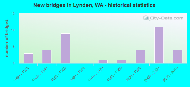
- New bridges - historical statistics
- 31930-1939
- 41940-1949
- 91950-1959
- 11970-1979
- 11980-1989
- 41990-1999
- 112000-2009
- 42010-2019
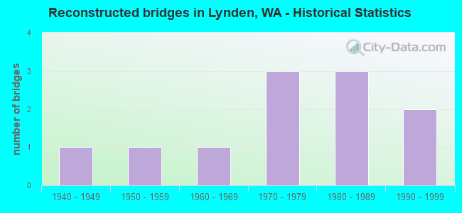
- Reconstructed bridges - Historical Statistics
- 11940-1949
- 11950-1959
- 11960-1969
- 31970-1979
- 31980-1989
- 21990-1999
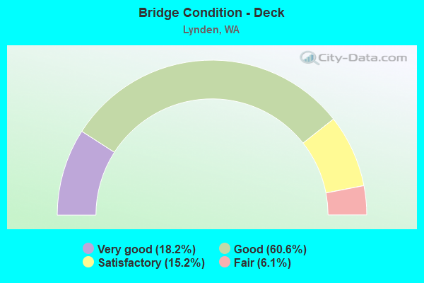
- Bridge Condition - Deck
- 18.2%Very good
- 60.6%Good
- 15.2%Satisfactory
- 6.1%Fair
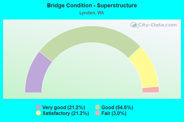
- Bridge Condition - Superstructure
- 21.2%Very good
- 54.5%Good
- 21.2%Satisfactory
- 3.0%Fair
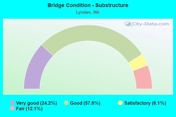
- Bridge Condition - Substructure
- 24.2%Very good
- 57.6%Good
- 6.1%Satisfactory
- 12.1%Fair
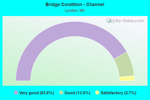
- Bridge Condition - Channel
- 83.8%Very good
- 13.5%Good
- 2.7%Satisfactory
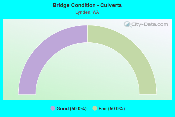
- Bridge Condition - Culverts
- 50.0%Good
- 50.0%Fair
Find on map >> Show street view
Structure Number: 3224A, Location: 0.9 N JCT SR 544 (Lat: 48.904586, Lng: -122.485611), Route carried "on" structure: State highway 539, Year Built: 1947, Status: Open, Structure Length: 1.83m (6.00ft), Average Daily Traffic: 8,557 (year 2019), Truck Traffic: 6%, Average Future Daily Traffic: 12,287 (year 2039), Design Load: HS 15, Features Intersected: WISER LAKE
Minimum Vertical Clearance: 30+ m (98+ ft), Kilometerpoint: 13.567, Lanes on structure: 2, Base Highway Network: Yes, Owner: State Highway Agency, Approaching Roadway Width: 11.6m (38.1ft), Material/Design: Concrete continuous, Design/Construction: Slab, Number Of Spans In Main Unit: 3, Length of Maximum Span: 6.7m (22.0ft), Curb-To-Curb Width: 11.6m (38.1ft), Out-to-Out Width: 12.0m (39.4ft)
Condition: Deck: Good, Superstructure: Good, Substructure: Good, Channel: Very good, Operating Rating: 24.3 metric tons, Method Used To Determine Operating Rating: Load and Resistance Factor Rating (LRFR) rating reported by rating factor(RF) method using HL-93 loadings, Inventory Rating: 18.8 metric tons, Method Used To Determine Inventory Rating: Load and Resistance Factor Rating (LRFR) rating reported by rating factor(RF) method using HL-93 loadings, Structural Evaluation: Meets minimum limits, Deck Geometry: Better than present minimum criteria, Waterway Adequacy: Equal to present desirable criteria, Approach Roadway Alignment: Equal to present desirable criteria, Length Of Structure Improvement: 1.83m (6.00ft), Designated Inspection Frequency: Every 48 months, Inspection Date: May 2018, Bridge Improvement Cost: $480,000, Roadway Improvement Cost: $96,000, Total Project Cost: $960,000 ( Estimate for 2014), Deck Structure Type: Concrete Cast-file-Place, Wearing Surface/Protective System: Wearing Surface: Bituminous, Membrane: Preformed Fabric
Find on map >> Show street view
Structure Number: 3802A, Location: 1.7 N JCT SR 544 (Lat: 48.915000, Lng: -122.485000), Route carried "on" structure: State highway 539, Year Built: 1950, Status: Open, Structure Length: 13.35m (43.80ft), Average Daily Traffic: 8,474 (year 2019), Truck Traffic: 6%, Average Future Daily Traffic: 12,168 (year 2039), Design Load: HS 20, Features Intersected: NOOKSACK R OVERFLOW
Minimum Vertical Clearance: 30+ m (98+ ft), Kilometerpoint: 14.725, Lanes on structure: 2, Base Highway Network: Yes, Owner: State Highway Agency, Approaching Roadway Width: 12.2m (40.0ft), Material/Design: Concrete continuous, Design/Construction: Slab, Number Of Spans In Main Unit: 23, Length of Maximum Span: 6.7m (22.0ft), Curb or Sidewalk Widths: Left: 0.8m (2.6ft), Right: 0.8m (2.6ft), Curb-To-Curb Width: 8.5m (27.9ft), Out-to-Out Width: 11.0m (36.1ft)
Condition: Deck: Good, Superstructure: Good, Substructure: Good, Channel: Very good, Operating Rating: 17.5 metric tons, Method Used To Determine Operating Rating: Load and Resistance Factor Rating (LRFR) rating reported by rating factor(RF) method using HL-93 loadings, Inventory Rating: 13.3 metric tons, Method Used To Determine Inventory Rating: Load and Resistance Factor Rating (LRFR) rating reported by rating factor(RF) method using HL-93 loadings, Structural Evaluation: High priority of corrective action, Deck Geometry: High priority of corrective action, Waterway Adequacy: Equal to present desirable criteria, Approach Roadway Alignment: Equal to present desirable criteria, Length Of Structure Improvement: 13.35m (43.80ft), Designated Inspection Frequency: Every 48 months, Inspection Date: May 2018, Bridge Improvement Cost: $3,679,000, Roadway Improvement Cost: $736,000, Total Project Cost: $7,358,000 ( Estimate for 2014), Deck Structure Type: Concrete Cast-file-Place, Wearing Surface/Protective System: Wearing Surface: Bituminous, Membrane: Preformed Fabric
Find on map >> Show street view
Structure Number: 3802B, Location: 2.0 N JCT SR 544 (Lat: 48.919269, Lng: -122.485536), Route carried "on" structure: State highway 539, Year Built: 1950, Status: Open, Structure Length: 17.56m (57.61ft), Average Daily Traffic: 8,474 (year 2019), Truck Traffic: 6%, Average Future Daily Traffic: 12,168 (year 2039), Design Load: HS 20, Features Intersected: NOOKSACK R
Minimum Vertical Clearance: 4.52m (14.83ft), Kilometerpoint: 15.176, Lanes on structure: 2, Base Highway Network: Yes, Owner: State Highway Agency, Approaching Roadway Width: 12.2m (40.0ft), Navigation Control: Yes ( Vertical Clearance: 2.4m (7.9ft), Horizontal Clearance: 62.5m (205.1ft)), Material/Design: Steel, Design/Construction: Truss - Thru, Number Of Spans In Main Unit: 1, Number Of Approach Spans: 7, Length of Maximum Span: 103.6m (339.9ft), Curb or Sidewalk Widths: Left: 0.8m (2.6ft), Right: 0.8m (2.6ft), Curb-To-Curb Width: 8.5m (27.9ft), Out-to-Out Width: 10.4m (34.1ft)
Condition: Deck: Good, Superstructure: Satisfactory, Substructure: Good, Channel: Good, Operating Rating: 33.6 metric tons, Method Used To Determine Operating Rating: Load Factor (LF), Inventory Rating: 20.0 metric tons, Method Used To Determine Inventory Rating: Load Factor (LF), Structural Evaluation: Somewhat better than minimum adequacy, Deck Geometry: High priority of corrective action, Waterway Adequacy: Equal to present desirable criteria, Approach Roadway Alignment: Equal to present desirable criteria, Length Of Structure Improvement: 17.56m (57.61ft), Designated Inspection Frequency: Every 24 months, Critical Feature Inspection Frequency: Every 24 months, Inspection Date: May 2021, Critical Feature Inspection Date: May 2021, Bridge Improvement Cost: $4,838,000, Roadway Improvement Cost: $968,000, Total Project Cost: $9,677,000 ( Estimate for 2014), Deck Structure Type: Concrete Cast-file-Place, Wearing Surface/Protective System: Wearing Surface: Bituminous, Membrane: Preformed Fabric
Find on map >> Show street view
Structure Number: 3802C, Location: 2.6 N JCT SR 544 (Lat: 48.929111, Lng: -122.485472), Route carried "on" structure: State highway 539, Year Built: 1950, Status: Open, Structure Length: 9.85m (32.32ft), Average Daily Traffic: 8,474 (year 2019), Truck Traffic: 6%, Average Future Daily Traffic: 12,168 (year 2039), Design Load: HS 20, Features Intersected: NOOKSACK R OVERFLOW
Minimum Vertical Clearance: 30+ m (98+ ft), Kilometerpoint: 16.270, Lanes on structure: 2, Base Highway Network: Yes, Owner: State Highway Agency, Approaching Roadway Width: 12.2m (40.0ft), Material/Design: Concrete continuous, Design/Construction: Slab, Number Of Spans In Main Unit: 17, Length of Maximum Span: 6.7m (22.0ft), Curb or Sidewalk Widths: Left: 0.8m (2.6ft), Right: 0.8m (2.6ft), Curb-To-Curb Width: 8.5m (27.9ft), Out-to-Out Width: 11.0m (36.1ft)
Condition: Deck: Good, Superstructure: Good, Substructure: Satisfactory, Channel: Satisfactory, Operating Rating: 15.9 metric tons, Method Used To Determine Operating Rating: Load and Resistance Factor Rating (LRFR) rating reported by rating factor(RF) method using HL-93 loadings, Inventory Rating: 12.3 metric tons, Method Used To Determine Inventory Rating: Load and Resistance Factor Rating (LRFR) rating reported by rating factor(RF) method using HL-93 loadings, Structural Evaluation: High priority of corrective action, Deck Geometry: High priority of corrective action, Waterway Adequacy: Equal to present minimum criteria, Approach Roadway Alignment: Equal to present desirable criteria, Length Of Structure Improvement: 9.85m (32.32ft), Designated Inspection Frequency: Every 48 months, Inspection Date: May 2018, Bridge Improvement Cost: $2,713,000, Roadway Improvement Cost: $543,000, Total Project Cost: $5,426,000 ( Estimate for 2014), Deck Structure Type: Concrete Cast-file-Place, Wearing Surface/Protective System: Wearing Surface: Bituminous, Membrane: Preformed Fabric
Find on map >> Show street view
Structure Number: 17469A, Location: 0.9 N JCT SR 544 (Lat: 48.904722, Lng: -122.485611), Route carried "on" structure: State highway 539, Year Built: 2009, Status: Open, Structure Length: 2.04m (6.69ft), Average Daily Traffic: 8,557 (year 2019), Truck Traffic: 6%, Average Future Daily Traffic: 12,287 (year 2039), Design Load: HL 93, Features Intersected: WISER LAKE
Minimum Vertical Clearance: 30+ m (98+ ft), Kilometerpoint: 13.567, Lanes on structure: 2, Base Highway Network: Yes, Owner: State Highway Agency, Approaching Roadway Width: 11.6m (38.1ft), Material/Design: Prestressed concrete, Design/Construction: Slab, Number Of Spans In Main Unit: 1, Length of Maximum Span: 19.5m (64.0ft), Curb-To-Curb Width: 11.6m (38.1ft), Out-to-Out Width: 12.5m (41.0ft)
Condition: Deck: Good, Superstructure: Good, Substructure: Good, Channel: Very good, Operating Rating: 61.7 metric tons, Method Used To Determine Operating Rating: Load Factor (LF), Inventory Rating: 36.3 metric tons, Method Used To Determine Inventory Rating: Load Factor (LF), Structural Evaluation: Better than present minimum criteria, Deck Geometry: Better than present minimum criteria, Waterway Adequacy: Equal to present desirable criteria, Approach Roadway Alignment: Equal to present desirable criteria, Length Of Structure Improvement: 2.04m (6.69ft), Designated Inspection Frequency: Every 48 months, Inspection Date: May 2018, Bridge Improvement Cost: $536,000, Roadway Improvement Cost: $107,000, Total Project Cost: $1,072,000 ( Estimate for 2014), Deck Structure Type: Concrete Cast-file-Place, Wearing Surface/Protective System: Wearing Surface: Monolithic Concrete, Deck Protection: Epoxy Coated Reinforcing
Find on map >> Show street view
Structure Number: 17469B, Location: 1.7 N JCT SR 544 (Lat: 48.915139, Lng: -122.485806), Route carried "on" structure: State highway 539, Year Built: 2009, Status: Open, Structure Length: 13.26m (43.50ft), Average Daily Traffic: 8,474 (year 2019), Truck Traffic: 6%, Average Future Daily Traffic: 12,168 (year 2039), Design Load: HL 93, Features Intersected: NOOKSACK R OVERFLOW
Minimum Vertical Clearance: 30+ m (98+ ft), Kilometerpoint: 14.725, Lanes on structure: 2, Base Highway Network: Yes, Owner: State Highway Agency, Approaching Roadway Width: 11.6m (38.1ft), Material/Design: Prestressed concrete continuous, Design/Construction: Slab, Number Of Spans In Main Unit: 7, Length of Maximum Span: 19.5m (64.0ft), Curb-To-Curb Width: 11.6m (38.1ft), Out-to-Out Width: 12.8m (42.0ft)
Condition: Deck: Good, Superstructure: Very good, Substructure: Very good, Channel: Very good, Operating Rating: 73.5 metric tons, Method Used To Determine Operating Rating: Load Factor (LF), Inventory Rating: 44.4 metric tons, Method Used To Determine Inventory Rating: Load Factor (LF), Structural Evaluation: Equal to present desirable criteria, Deck Geometry: Better than present minimum criteria, Waterway Adequacy: Equal to present desirable criteria, Approach Roadway Alignment: Equal to present desirable criteria, Length Of Structure Improvement: 13.26m (43.50ft), Designated Inspection Frequency: Every 48 months, Inspection Date: May 2018, Bridge Improvement Cost: $3,480,000, Roadway Improvement Cost: $696,000, Total Project Cost: $6,960,000 ( Estimate for 2014), Deck Structure Type: Concrete Cast-file-Place, Wearing Surface/Protective System: Wearing Surface: Monolithic Concrete, Deck Protection: Epoxy Coated Reinforcing
Find on map >> Show street view
Structure Number: 17469C, Location: 2.0 N JCT SR 544 (Lat: 48.919250, Lng: -122.485750), Route carried "on" structure: State highway 539, Year Built: 2009, Status: Open, Structure Length: 17.98m (58.99ft), Average Daily Traffic: 8,474 (year 2019), Truck Traffic: 6%, Average Future Daily Traffic: 12,168 (year 2039), Design Load: HL 93, Features Intersected: NOOKSACK RIVER
Minimum Vertical Clearance: 8.25m (27.07ft), Kilometerpoint: 15.176, Lanes on structure: 2, Base Highway Network: Yes, Owner: State Highway Agency, Approaching Roadway Width: 12.2m (40.0ft), Material/Design: Steel, Design/Construction: Truss - Thru, Number Of Spans In Main Unit: 1, Number Of Approach Spans: 2, Length of Maximum Span: 107.6m (353.0ft), Curb-To-Curb Width: 12.2m (40.0ft), Out-to-Out Width: 13.1m (43.0ft)
Condition: Deck: Very good, Superstructure: Very good, Substructure: Very good, Channel: Very good, Operating Rating: 64.4 metric tons, Method Used To Determine Operating Rating: Load Factor (LF), Inventory Rating: 39.0 metric tons, Method Used To Determine Inventory Rating: Load Factor (LF), Structural Evaluation: Equal to present desirable criteria, Deck Geometry: Better than present minimum criteria, Waterway Adequacy: Equal to present desirable criteria, Approach Roadway Alignment: Equal to present desirable criteria, Length Of Structure Improvement: 17.98m (58.99ft), Designated Inspection Frequency: Every 24 months, Critical Feature Inspection Frequency: Every 24 months, Inspection Date: October 2020, Critical Feature Inspection Date: October 2020, Bridge Improvement Cost: $4,956,000, Roadway Improvement Cost: $991,000, Total Project Cost: $9,912,000 ( Estimate for 2014), Deck Structure Type: Concrete Cast-file-Place, Wearing Surface/Protective System: Wearing Surface: Monolithic Concrete, Deck Protection: Epoxy Coated Reinforcing
Find on map >> Show street view
Structure Number: 17469D, Location: 2.6 N JCT SR 544 (Lat: 48.929056, Lng: -122.485611), Route carried "on" structure: State highway 539, Year Built: 2009, Status: Open, Structure Length: 9.72m (31.89ft), Average Daily Traffic: 8,474 (year 2019), Truck Traffic: 6%, Average Future Daily Traffic: 12,168 (year 2039), Design Load: HL 93, Features Intersected: NOOKSACK R OVERFLOW
Minimum Vertical Clearance: 30+ m (98+ ft), Kilometerpoint: 16.270, Lanes on structure: 2, Base Highway Network: Yes, Owner: State Highway Agency, Approaching Roadway Width: 11.9m (39.0ft), Material/Design: Prestressed concrete continuous, Design/Construction: Slab, Number Of Spans In Main Unit: 5, Length of Maximum Span: 20.1m (65.9ft), Curb-To-Curb Width: 11.9m (39.0ft), Out-to-Out Width: 12.8m (42.0ft)
Condition: Deck: Very good, Superstructure: Very good, Substructure: Very good, Channel: Very good, Operating Rating: 69.8 metric tons, Method Used To Determine Operating Rating: Load Factor (LF), Inventory Rating: 41.7 metric tons, Method Used To Determine Inventory Rating: Load Factor (LF), Structural Evaluation: Equal to present desirable criteria, Deck Geometry: Better than present minimum criteria, Waterway Adequacy: Equal to present desirable criteria, Approach Roadway Alignment: Equal to present desirable criteria, Length Of Structure Improvement: 9.72m (31.89ft), Designated Inspection Frequency: Every 48 months, Inspection Date: May 2018, Bridge Improvement Cost: $2,616,000, Roadway Improvement Cost: $523,000, Total Project Cost: $5,232,000 ( Estimate for 2014), Deck Structure Type: Concrete Precast Panels, Wearing Surface/Protective System: Wearing Surface: Monolithic Concrete, Deck Protection: Epoxy Coated Reinforcing
Find on map >> Show street view
Structure Number: 17469E, Location: 2.7 N JCT SR 544 (Lat: 48.931083, Lng: -122.485472), Route carried "on" structure: State highway 539, Year Built: 2008, Status: Open, Structure Length: 3.11m (10.20ft), Average Daily Traffic: 16,948 (year 2019), Truck Traffic: 6%, Average Future Daily Traffic: 24,337 (year 2039), Design Load: HL 93, Features Intersected: FISHTRAP CREEK
Minimum Vertical Clearance: 30+ m (98+ ft), Kilometerpoint: 16.496, Lanes on structure: 4, Base Highway Network: Yes, Owner: State Highway Agency, Approaching Roadway Width: 20.7m (67.9ft), Skew: 32 degrees, Material/Design: Prestressed concrete, Design/Construction: Stringer/Multi-beam, Number Of Spans In Main Unit: 1, Length of Maximum Span: 30.5m (100.1ft), Curb-To-Curb Width: 25.6m (84.0ft), Out-to-Out Width: 26.5m (86.9ft)
Condition: Deck: Very good, Superstructure: Very good, Substructure: Very good, Channel: Very good, Operating Rating: 83.4 metric tons, Method Used To Determine Operating Rating: Load Factor (LF), Inventory Rating: 49.0 metric tons, Method Used To Determine Inventory Rating: Load Factor (LF), Structural Evaluation: Equal to present desirable criteria, Deck Geometry: Superior to present desirable criteria, Waterway Adequacy: Equal to present desirable criteria, Approach Roadway Alignment: Equal to present desirable criteria, Length Of Structure Improvement: 3.11m (10.20ft), Designated Inspection Frequency: Every 48 months, Inspection Date: July 2020, Bridge Improvement Cost: $1,428,000, Roadway Improvement Cost: $286,000, Total Project Cost: $2,856,000 ( Estimate for 2014), Deck Structure Type: Concrete Cast-file-Place, Wearing Surface/Protective System: Wearing Surface: Monolithic Concrete, Deck Protection: Epoxy Coated Reinforcing
Find on map >> Show street view
Structure Number: 17469F, Location: 2.5 N JCT SR 544 (Lat: 48.927833, Lng: -122.485500), Route carried "on" structure: State highway 539, Year Built: 2009, Status: Open, Structure Length: 0.82m (2.69ft), Average Daily Traffic: 16,948 (year 2019), Truck Traffic: 6%, Average Future Daily Traffic: 24,337 (year 2039), Design Load: HL 93, Features Intersected: NOOKSACK R OVERFLOW
Minimum Vertical Clearance: 30+ m (98+ ft), Kilometerpoint: 16.142, Lanes on structure: 4, Base Highway Network: Yes, Owner: State Highway Agency, Approaching Roadway Width: 34.1m (111.9ft), Material/Design: Concrete, Design/Construction: Culvert, Number Of Spans In Main Unit: 1, Length of Maximum Span: 7.6m (24.9ft)
Condition: Channel: Very good, Culverts: Good, Operating Rating: 64.4 metric tons, Method Used To Determine Operating Rating: Load Factor (LF), Inventory Rating: 39.0 metric tons, Method Used To Determine Inventory Rating: Load Factor (LF), Structural Evaluation: Better than present minimum criteria, Waterway Adequacy: Equal to present desirable criteria, Approach Roadway Alignment: Equal to present desirable criteria, Length Of Structure Improvement: 0.82m (2.69ft), Designated Inspection Frequency: Every 48 months, Inspection Date: July 2020, Bridge Improvement Cost: $616,000, Roadway Improvement Cost: $123,000, Total Project Cost: $1,231,000 ( Estimate for 2014)
Find on map >> Show street view
Structure Number: 17469G, Location: 1.5 N JCT SR 544 (Lat: 48.914917, Lng: -122.485722), Route carried "on" structure: State highway 539, Year Built: 2009, Status: Open, Structure Length: 0.76m (2.49ft), Average Daily Traffic: 16,948 (year 2019), Truck Traffic: 6%, Average Future Daily Traffic: 24,337 (year 2039), Design Load: HL 93, Features Intersected: NOOKSACK R OVERFLOW
Minimum Vertical Clearance: 30+ m (98+ ft), Kilometerpoint: 14.693, Lanes on structure: 4, Base Highway Network: Yes, Owner: State Highway Agency, Approaching Roadway Width: 23.5m (77.1ft), Material/Design: Concrete, Design/Construction: Culvert, Number Of Spans In Main Unit: 1, Length of Maximum Span: 7.6m (24.9ft)
Condition: Channel: Very good, Culverts: Good, Operating Rating: 49.9 metric tons, Method Used To Determine Operating Rating: Load Factor (LF), Inventory Rating: 29.9 metric tons, Method Used To Determine Inventory Rating: Load Factor (LF), Structural Evaluation: Better than present minimum criteria, Waterway Adequacy: Equal to present desirable criteria, Approach Roadway Alignment: Equal to present desirable criteria, Length Of Structure Improvement: 0.76m (2.49ft), Designated Inspection Frequency: Every 48 months, Inspection Date: May 2018, Bridge Improvement Cost: $395,000, Roadway Improvement Cost: $79,000, Total Project Cost: $790,000 ( Estimate for 2014)
Find on map >> Show street view
Structure Number: 80126, Location: 00.1 MI N PANGBORN (Lat: 48.979925, Lng: -122.429253), Route carried "on" structure: County highway 61050, Year Built: 1949, Year Reconstructed: 1974, Status: Posted for load, Structure Length: 0.94m (3.08ft), Average Daily Traffic: 195 (year 2018), Truck Traffic: 5%, Average Future Daily Traffic: 210 (year 2038), Design Load: H 20, Features Intersected: FISHTRAP CR, Facility Carried by Structure: ASSINK RD
Minimum Vertical Clearance: 30+ m (98+ ft), Kilometerpoint: 0.001, Lanes on structure: 2, Owner: County Highway Agency, Approaching Roadway Width: 6.7m (22.0ft), Material/Design: Concrete, Design/Construction: Channel Beam, Number Of Spans In Main Unit: 1, Length of Maximum Span: 9.4m (30.8ft), Curb-To-Curb Width: 7.3m (24.0ft), Out-to-Out Width: 7.8m (25.6ft)
Condition: Deck: Satisfactory, Superstructure: Satisfactory, Substructure: Fair, Channel: Good, Operating Rating: 22.7 metric tons, Method Used To Determine Operating Rating: Load and Resistance Factor (LRFR), Inventory Rating: 16.3 metric tons, Method Used To Determine Inventory Rating: Load and Resistance Factor (LRFR), Structural Evaluation: Somewhat better than minimum adequacy, Deck Geometry: Somewhat better than minimum adequacy, Waterway Adequacy: Equal to present desirable criteria, Approach Roadway Alignment: Equal to present desirable criteria, Bridge Posting: Required (Relationship of Operating Rating to Maximum Legal Load: 0.1 - 9.9% below), Length Of Structure Improvement: 1.25m (4.10ft), Designated Inspection Frequency: Every 24 months, Inspection Date: September 2020, Bridge Improvement Cost: $623,000, Roadway Improvement Cost: $125,000, Total Project Cost: $1,246,000 ( Estimate for 2014), Deck Structure Type: Other, Wearing Surface/Protective System: Wearing Surface: Bituminous
Find on map >> Show street view
Structure Number: 80901, Location: 0.1 W ASSINK RD. (Lat: 48.978844, Lng: -122.429472), Route carried "on" structure: County highway 60960, Year Built: 1954, Year Reconstructed: 1998, Status: Open, Structure Length: 1.16m (3.81ft), Average Daily Traffic: 700 (year 2021), Truck Traffic: 6%, Average Future Daily Traffic: 900 (year 2042), Design Load: H 20, Features Intersected: FISH TRAP CR, Facility Carried by Structure: PANGBORN RD
Minimum Vertical Clearance: 30+ m (98+ ft), Kilometerpoint: 0.001, Lanes on structure: 2, Owner: County Highway Agency, Approaching Roadway Width: 9.1m (29.9ft), Material/Design: Concrete, Design/Construction: Channel Beam, Number Of Spans In Main Unit: 2, Length of Maximum Span: 5.8m (19.0ft), Curb-To-Curb Width: 8.7m (28.5ft), Out-to-Out Width: 9.2m (30.2ft)
Condition: Deck: Satisfactory, Superstructure: Satisfactory, Substructure: Good, Channel: Very good, Operating Rating: 24.9 metric tons, Method Used To Determine Operating Rating: Load and Resistance Factor Rating (LRFR) rating reported by rating factor(RF) method using HL-93 loadings, Inventory Rating: 19.4 metric tons, Method Used To Determine Inventory Rating: Load and Resistance Factor Rating (LRFR) rating reported by rating factor(RF) method using HL-93 loadings, Structural Evaluation: Somewhat better than minimum adequacy, Deck Geometry: Somewhat better than minimum adequacy, Waterway Adequacy: Equal to present desirable criteria, Approach Roadway Alignment: Equal to present desirable criteria, Length Of Structure Improvement: 1.46m (4.79ft), Designated Inspection Frequency: Every 24 months, Inspection Date: October 2020, Bridge Improvement Cost: $730,000, Roadway Improvement Cost: $146,000, Total Project Cost: $1,459,000 ( Estimate for 2014), Deck Structure Type: Other, Wearing Surface/Protective System: Wearing Surface: Monolithic Concrete
Find on map >> Show street view
Structure Number: 80934, Location: 00.2 S BEARD RD. (Lat: 48.882206, Lng: -122.442550), Route carried "on" structure: County highway 55110, Year Built: 1954, Year Reconstructed: 1994, Status: Open, Structure Length: 1.13m (3.71ft), Average Daily Traffic: 9,411 (year 2021), Truck Traffic: 4%, Average Future Daily Traffic: 15,000 (year 2043), Design Load: HS 20, Features Intersected: FOUR MILE CREEK, Facility Carried by Structure: HANNEGAN RD
Minimum Vertical Clearance: 30+ m (98+ ft), Kilometerpoint: 0.001, Lanes on structure: 2, Owner: County Highway Agency, Approaching Roadway Width: 12.5m (41.0ft), Skew: 2 degrees, Material/Design: Prestressed concrete, Design/Construction: Slab, Number Of Spans In Main Unit: 1, Length of Maximum Span: 11.3m (37.1ft), Curb-To-Curb Width: 12.2m (40.0ft), Out-to-Out Width: 13.4m (44.0ft)
Condition: Deck: Good, Superstructure: Good, Substructure: Good, Channel: Very good, Operating Rating: 89.8 metric tons, Method Used To Determine Operating Rating: Load Factor (LF), Inventory Rating: 45.4 metric tons, Method Used To Determine Inventory Rating: Load Factor (LF), Structural Evaluation: Better than present minimum criteria, Deck Geometry: Somewhat better than minimum adequacy, Waterway Adequacy: Equal to present desirable criteria, Approach Roadway Alignment: Equal to present desirable criteria, Length Of Structure Improvement: 1.43m (4.69ft), Designated Inspection Frequency: Every 24 months, Inspection Date: March 2021, Bridge Improvement Cost: $714,000, Roadway Improvement Cost: $143,000, Total Project Cost: $1,429,000 ( Estimate for 2014), Deck Structure Type: Concrete Precast Panels, Wearing Surface/Protective System: Wearing Surface: Bituminous, Membrane: Preformed Fabric
Find on map >> Show street view
Structure Number: 81682, Location: 00.6 W BERTHUSEN RD (Lat: 48.949900, Lng: -122.520872), Route carried "on" structure: County highway 26502, Year Built: 1938, Year Reconstructed: 1953, Status: Posted for load, Structure Length: 3.84m (12.60ft), Average Daily Traffic: 1,839 (year 2020), Truck Traffic: 5%, Average Future Daily Traffic: 2,200 (year 2042), Features Intersected: BERTRAND CR, Facility Carried by Structure: LOOMIS TRAIL RD
Minimum Vertical Clearance: 30+ m (98+ ft), Kilometerpoint: 0.001, Lanes on structure: 2, Owner: County Highway Agency, Approaching Roadway Width: 11.6m (38.1ft), Material/Design: Concrete, Design/Construction: Slab, Number Of Spans In Main Unit: 5, Length of Maximum Span: 7.9m (25.9ft), Curb or Sidewalk Widths: Left: 0.9m (3.0ft), Right: 0.9m (3.0ft), Curb-To-Curb Width: 7.9m (25.9ft), Out-to-Out Width: 10.1m (33.1ft)
Condition: Deck: Fair, Superstructure: Fair, Substructure: Good, Channel: Very good, Operating Rating: 21.8 metric tons, Method Used To Determine Operating Rating: Load and Resistance Factor (LRFR), Inventory Rating: 16.3 metric tons, Method Used To Determine Inventory Rating: Load and Resistance Factor (LRFR), Structural Evaluation: Meets minimum limits, Deck Geometry: Meets minimum limits, Waterway Adequacy: Equal to present desirable criteria, Approach Roadway Alignment: Equal to present desirable criteria, Bridge Posting: Required (Relationship of Operating Rating to Maximum Legal Load: 0.1 - 9.9% below), Length Of Structure Improvement: 4.15m (13.62ft), Designated Inspection Frequency: Every 24 months, Inspection Date: April 2020, Bridge Improvement Cost: $2,067,000, Roadway Improvement Cost: $413,000, Total Project Cost: $4,134,000 ( Estimate for 2014), Deck Structure Type: Concrete Cast-file-Place, Wearing Surface/Protective System: Wearing Surface: Bituminous
Find on map >> Show street view
Structure Number: 82017, Location: 00.3 E HANNEGAN RD. (Lat: 48.869842, Lng: -122.437053), Route carried "on" structure: County highway 56420, Year Built: 1934, Year Reconstructed: 1993, Status: Open, Structure Length: 1.16m (3.81ft), Average Daily Traffic: 372 (year 2020), Truck Traffic: 2%, Average Future Daily Traffic: 500 (year 2042), Design Load: H 20, Features Intersected: TEN MILE CR, Facility Carried by Structure: TEN MILE RD
Minimum Vertical Clearance: 30+ m (98+ ft), Kilometerpoint: 0.001, Lanes on structure: 2, Owner: County Highway Agency, Approaching Roadway Width: 8.8m (28.9ft), Material/Design: Concrete, Design/Construction: Channel Beam, Number Of Spans In Main Unit: 2, Length of Maximum Span: 5.8m (19.0ft), Curb-To-Curb Width: 7.3m (24.0ft), Out-to-Out Width: 7.8m (25.6ft)
Condition: Deck: Satisfactory, Superstructure: Satisfactory, Substructure: Fair, Channel: Very good, Operating Rating: 24.3 metric tons, Method Used To Determine Operating Rating: Load and Resistance Factor Rating (LRFR) rating reported by rating factor(RF) method using HL-93 loadings, Inventory Rating: 18.8 metric tons, Method Used To Determine Inventory Rating: Load and Resistance Factor Rating (LRFR) rating reported by rating factor(RF) method using HL-93 loadings, Structural Evaluation: Somewhat better than minimum adequacy, Deck Geometry: Somewhat better than minimum adequacy, Waterway Adequacy: Equal to present desirable criteria, Approach Roadway Alignment: Equal to present desirable criteria, Length Of Structure Improvement: 1.46m (4.79ft), Designated Inspection Frequency: Every 24 months, Inspection Date: November 2020, Bridge Improvement Cost: $730,000, Roadway Improvement Cost: $146,000, Total Project Cost: $1,459,000 ( Estimate for 2014), Deck Structure Type: Other, Wearing Surface/Protective System: Wearing Surface: Monolithic Concrete
Find on map >> Show street view
Structure Number: 82688, Location: 00.1 N POLINDER RD. (Lat: 48.936792, Lng: -122.442114), Route carried "on" structure: County highway 55110, Year Built: 1934, Year Reconstructed: 1961, Status: Open, Structure Length: 9.75m (31.99ft), Average Daily Traffic: 9,332 (year 2018), Truck Traffic: 3%, Average Future Daily Traffic: 12,000 (year 2040), Design Load: HS 20, Features Intersected: NOOKSACK RIVER, Facility Carried by Structure: HANNEGAN RD
Minimum Vertical Clearance: 30+ m (98+ ft), Kilometerpoint: 0.001, Lanes on structure: 2, Owner: County Highway Agency, Approaching Roadway Width: 12.2m (40.0ft), Material/Design: Steel, Design/Construction: Stringer/Multi-beam, Number Of Spans In Main Unit: 1, Number Of Approach Spans: 2, Length of Maximum Span: 36.6m (120.1ft), Curb or Sidewalk Widths: Left: 0.5m (1.6ft), Right: 0.5m (1.6ft), Curb-To-Curb Width: 7.9m (25.9ft), Out-to-Out Width: 9.1m (29.9ft)
Condition: Deck: Satisfactory, Superstructure: Satisfactory, Substructure: Good, Channel: Good, Operating Rating: 39.0 metric tons, Method Used To Determine Operating Rating: Load Factor (LF), Inventory Rating: 22.7 metric tons, Method Used To Determine Inventory Rating: Load Factor (LF), Structural Evaluation: Somewhat better than minimum adequacy, Deck Geometry: High priority of corrective action, Waterway Adequacy: Equal to present desirable criteria, Approach Roadway Alignment: Equal to present desirable criteria, Length Of Structure Improvement: 10.06m (33.01ft), Designated Inspection Frequency: Every 24 months, Critical Feature Inspection Frequency: Every 24 months, Underwater Inspection Frequency: Every 24 months, Inspection Date: March 2020, Critical Feature Inspection Date: March 2020, Underwater Inspection Date: September 2020, Bridge Improvement Cost: $5,016,000, Roadway Improvement Cost: $1,003,000, Total Project Cost: $10,032,000 ( Estimate for 2014), Deck Structure Type: Concrete Cast-file-Place, Wearing Surface/Protective System: Wearing Surface: Monolithic Concrete
Find on map >> Show street view
Structure Number: 82977, Location: 00.3 W.RATHBONE RD. (Lat: 48.948333, Lng: -122.533333), Route carried "on" structure: County highway 21580, Year Built: 1949, Year Reconstructed: 1982, Status: Open, Structure Length: 2.53m (8.30ft), Average Daily Traffic: 8,369 (year 2018), Truck Traffic: 12%, Average Future Daily Traffic: 10,500 (year 2040), Design Load: H 15, Features Intersected: BERTRAND CR, Facility Carried by Structure: BIRCH BAY LYNDEN
Minimum Vertical Clearance: 30+ m (98+ ft), Kilometerpoint: 0.001, Lanes on structure: 2, Owner: County Highway Agency, Approaching Roadway Width: 9.8m (32.2ft), Material/Design: Concrete, Design/Construction: Slab, Number Of Spans In Main Unit: 4, Length of Maximum Span: 6.7m (22.0ft), Curb-To-Curb Width: 7.3m (24.0ft), Out-to-Out Width: 8.2m (26.9ft)
Condition: Deck: Fair, Superstructure: Satisfactory, Substructure: Good, Channel: Very good, Operating Rating: 61.7 metric tons, Method Used To Determine Operating Rating: Load Factor (LF), Inventory Rating: 37.2 metric tons, Method Used To Determine Inventory Rating: Load Factor (LF), Structural Evaluation: Equal to present minimum criteria, Deck Geometry: High priority of replacement, Waterway Adequacy: Equal to present desirable criteria, Approach Roadway Alignment: Equal to present minimum criteria, Length Of Structure Improvement: 2.83m (9.28ft), Designated Inspection Frequency: Every 24 months, Inspection Date: October 2021, Bridge Improvement Cost: $1,414,000, Roadway Improvement Cost: $283,000, Total Project Cost: $2,827,000 ( Estimate for 2014), Deck Structure Type: Concrete Cast-file-Place, Wearing Surface/Protective System: Wearing Surface: Monolithic Concrete
Find on map >> Show street view
Structure Number: 83417, Location: 00.4 SW B.B. LYNDEN (Lat: 48.926317, Lng: -122.496297), Route carried "on" structure: County highway 31630, Year Built: 1988, Status: Posted for load, Structure Length: 1.10m (3.61ft), Average Daily Traffic: 125 (year 2019), Truck Traffic: 1%, Average Future Daily Traffic: 200 (year 2041), Features Intersected: FISHTRAP CR, Facility Carried by Structure: FLYNN RD
Minimum Vertical Clearance: 30+ m (98+ ft), Kilometerpoint: 0.001, Lanes on structure: 2, Owner: County Highway Agency, Approaching Roadway Width: 5.5m (18.0ft), Material/Design: Wood or Timber, Design/Construction: Stringer/Multi-beam, Number Of Spans In Main Unit: 1, Length of Maximum Span: 11.0m (36.1ft), Curb-To-Curb Width: 4.9m (16.1ft), Out-to-Out Width: 5.2m (17.1ft)
Condition: Deck: Very good, Superstructure: Satisfactory, Substructure: Fair, Channel: Very good, Operating Rating: 40.8 metric tons, Method Used To Determine Operating Rating: Allowable Stress (AS), Inventory Rating: 29.9 metric tons, Method Used To Determine Inventory Rating: Allowable Stress (AS), Structural Evaluation: Somewhat better than minimum adequacy, Deck Geometry: High priority of replacement, Waterway Adequacy: Better than present minimum criteria, Approach Roadway Alignment: Equal to present desirable criteria, Length Of Structure Improvement: 1.40m (4.59ft), Designated Inspection Frequency: Every 24 months, Inspection Date: August 2020, Bridge Improvement Cost: $699,000, Roadway Improvement Cost: $140,000, Total Project Cost: $1,398,000 ( Estimate for 2014), Deck Structure Type: Wood or Timber, Wearing Surface/Protective System: Wearing Surface: Wood or Timber
Find on map >> Show street view
Structure Number: 83596, Location: 00.8 S B.B.-LYN. RD (Lat: 48.924150, Lng: -122.530108), Route carried "on" structure: County highway 31340, Year Built: 1950, Year Reconstructed: 1983, Status: Open, Structure Length: 2.50m (8.20ft), Average Daily Traffic: 1,522 (year 2017), Truck Traffic: 11%, Average Future Daily Traffic: 2,000 (year 2039), Design Load: HS 20, Features Intersected: BERTRAND CREEK, Facility Carried by Structure: RATHBONE RD
Minimum Vertical Clearance: 30+ m (98+ ft), Kilometerpoint: 0.001, Lanes on structure: 2, Owner: County Highway Agency, Approaching Roadway Width: 11.0m (36.1ft), Material/Design: Prestressed concrete, Design/Construction: Tee Beam, Number Of Spans In Main Unit: 1, Length of Maximum Span: 25.0m (82.0ft), Curb-To-Curb Width: 10.4m (34.1ft), Out-to-Out Width: 11.0m (36.1ft)
Condition: Deck: Good, Superstructure: Good, Substructure: Good, Channel: Very good, Operating Rating: 28.8 metric tons, Method Used To Determine Operating Rating: Load and Resistance Factor Rating (LRFR) rating reported by rating factor(RF) method using HL-93 loadings, Inventory Rating: 22.7 metric tons, Method Used To Determine Inventory Rating: Load and Resistance Factor Rating (LRFR) rating reported by rating factor(RF) method using HL-93 loadings, Structural Evaluation: Equal to present minimum criteria, Deck Geometry: Equal to present minimum criteria, Waterway Adequacy: Equal to present desirable criteria, Approach Roadway Alignment: Equal to present minimum criteria, Length Of Structure Improvement: 2.80m (9.19ft), Designated Inspection Frequency: Every 24 months, Inspection Date: January 2021, Bridge Improvement Cost: $1,398,000, Roadway Improvement Cost: $280,000, Total Project Cost: $2,797,000 ( Estimate for 2014), Deck Structure Type: Other, Wearing Surface/Protective System: Wearing Surface: Bituminous
Find on map >> Show street view
Structure Number: 84335, Location: 00.7 N E. WISER LK. (Lat: 48.918931, Lng: -122.464083), Route carried "on" structure: County highway 59160, Year Built: 1951, Year Reconstructed: 1979, Status: Open, Structure Length: 0.94m (3.08ft), Average Daily Traffic: 72 (year 2018), Truck Traffic: 4%, Average Future Daily Traffic: 150 (year 2040), Design Load: H 20, Features Intersected: DRAINAGE DITCH, Facility Carried by Structure: BYLSMA RD
Minimum Vertical Clearance: 30+ m (98+ ft), Kilometerpoint: 0.001, Lanes on structure: 2, Owner: County Highway Agency, Approaching Roadway Width: 7.6m (24.9ft), Material/Design: Concrete, Design/Construction: Channel Beam, Number Of Spans In Main Unit: 1, Length of Maximum Span: 9.4m (30.8ft), Curb-To-Curb Width: 7.3m (24.0ft), Out-to-Out Width: 7.8m (25.6ft)
Condition: Deck: Good, Superstructure: Good, Substructure: Fair, Channel: Very good, Operating Rating: 26.3 metric tons, Method Used To Determine Operating Rating: Load and Resistance Factor (LRFR), Inventory Rating: 19.0 metric tons, Method Used To Determine Inventory Rating: Load and Resistance Factor (LRFR), Structural Evaluation: Somewhat better than minimum adequacy, Deck Geometry: Equal to present minimum criteria, Waterway Adequacy: Equal to present desirable criteria, Approach Roadway Alignment: Equal to present desirable criteria, Length Of Structure Improvement: 1.25m (4.10ft), Designated Inspection Frequency: Every 24 months, Inspection Date: January 2021, Bridge Improvement Cost: $623,000, Roadway Improvement Cost: $125,000, Total Project Cost: $1,246,000 ( Estimate for 2014), Deck Structure Type: Other, Wearing Surface/Protective System: Wearing Surface: Monolithic Concrete
Find on map >> Show street view
Structure Number: 84593, Location: 00.2 S E BOUNDARY (Lat: 49.000544, Lng: -122.407697), Route carried "on" structure: County highway 61630, Year Built: 1950, Year Reconstructed: 1993, Status: Open, Structure Length: 0.94m (3.08ft), Average Daily Traffic: 300 (year 2016), Truck Traffic: 4%, Average Future Daily Traffic: 600 (year 2038), Design Load: H 20, Features Intersected: FISH TRAP CR, Facility Carried by Structure: NORTHWOOD RD
Minimum Vertical Clearance: 30+ m (98+ ft), Kilometerpoint: 0.001, Lanes on structure: 2, Owner: County Highway Agency, Approaching Roadway Width: 7.3m (24.0ft), Material/Design: Concrete, Design/Construction: Channel Beam, Number Of Spans In Main Unit: 1, Length of Maximum Span: 9.4m (30.8ft), Curb-To-Curb Width: 7.3m (24.0ft), Out-to-Out Width: 8.2m (26.9ft)
Condition: Deck: Good, Superstructure: Good, Substructure: Good, Channel: Very good, Operating Rating: 46.3 metric tons, Method Used To Determine Operating Rating: Load Factor (LF), Inventory Rating: 29.9 metric tons, Method Used To Determine Inventory Rating: Load Factor (LF), Structural Evaluation: Better than present minimum criteria, Deck Geometry: Somewhat better than minimum adequacy, Waterway Adequacy: Better than present minimum criteria, Approach Roadway Alignment: Equal to present desirable criteria, Length Of Structure Improvement: 1.25m (4.10ft), Designated Inspection Frequency: Every 24 months, Inspection Date: September 2020, Bridge Improvement Cost: $623,000, Roadway Improvement Cost: $125,000, Total Project Cost: $1,246,000 ( Estimate for 2014), Deck Structure Type: Other, Wearing Surface/Protective System: Wearing Surface: Monolithic Concrete
Find on map >> Show street view
Structure Number: 85332, Location: AT LIBERTY (Lat: 48.943194, Lng: -122.469167), Route carried "on" structure: City street 710, Year Built: 1975, Status: Posted for load, Structure Length: 0.79m (2.59ft), Average Daily Traffic: 1,140 (year 2018), Truck Traffic: 5%, Average Future Daily Traffic: 1,500 (year 2040), Design Load: HS 20, Features Intersected: FISHTRAP CREEK, Facility Carried by Structure: N 17TH STREET
Minimum Vertical Clearance: 30+ m (98+ ft), Kilometerpoint: 0.001, Lanes on structure: 2, Owner: City or Municipal Highway Agency, Approaching Roadway Width: 12.2m (40.0ft), Material/Design: Concrete, Design/Construction: Culvert, Number Of Spans In Main Unit: 3, Length of Maximum Span: 2.4m (7.9ft)
Condition: Channel: Very good, Culverts: Fair, Operating Rating: 43.5 metric tons, Method Used To Determine Operating Rating: Field evaluation and documented engineering judgment, Inventory Rating: 25.4 metric tons, Method Used To Determine Inventory Rating: Field evaluation and documented engineering judgment, Structural Evaluation: Somewhat better than minimum adequacy, Waterway Adequacy: Equal to present desirable criteria, Approach Roadway Alignment: Equal to present desirable criteria, Bridge Posting: Required (Relationship of Operating Rating to Maximum Legal Load: 20.0 - 29.9% below), Length Of Structure Improvement: 1.52m (4.99ft), Designated Inspection Frequency: Every 24 months, Inspection Date: January 2021, Bridge Improvement Cost: $1,300,000, Roadway Improvement Cost: $200,000, Total Project Cost: $1,500,000 ( Estimate for 2020)
Find on map >> Show street view
Structure Number: 85334, Location: 0.3 E SR539 (Lat: 48.938722, Lng: -122.479194), Route carried "on" structure: City street 710, Year Built: 1947, Status: Open, Structure Length: 1.04m (3.41ft), Average Daily Traffic: 6,187 (year 2018), Truck Traffic: 10%, Average Future Daily Traffic: 8,500 (year 2040), Design Load: HS 20, Features Intersected: FISHTRAP CREEK, Facility Carried by Structure: FRONT STREET
Minimum Vertical Clearance: 30+ m (98+ ft), Kilometerpoint: 0.001, Lanes on structure: 3, Owner: City or Municipal Highway Agency, Approaching Roadway Width: 11.0m (36.1ft), Material/Design: Concrete, Design/Construction: Culvert, Number Of Spans In Main Unit: 3, Length of Maximum Span: 3.0m (9.8ft)
Condition: Channel: Very good, Culverts: Fair, Operating Rating: 54.4 metric tons, Method Used To Determine Operating Rating: Field evaluation and documented engineering judgment, Inventory Rating: 32.7 metric tons, Method Used To Determine Inventory Rating: Field evaluation and documented engineering judgment, Structural Evaluation: Somewhat better than minimum adequacy, Waterway Adequacy: Equal to present minimum criteria, Approach Roadway Alignment: Equal to present desirable criteria, Length Of Structure Improvement: 1.34m (4.40ft), Designated Inspection Frequency: Every 24 months, Inspection Date: January 2021, Bridge Improvement Cost: $880,000, Roadway Improvement Cost: $176,000, Total Project Cost: $1,760,000 ( Estimate for 2014)
Find on map >> Show street view
Structure Number: 86044, Location: 0.6 N FRONT ST (Lat: 48.949500, Lng: -122.452639), Route carried "on" structure: City street 710, Year Built: 1992, Status: Open, Structure Length: 1.13m (3.71ft), Average Daily Traffic: 6,187 (year 2018), Truck Traffic: 10%, Average Future Daily Traffic: 8,000 (year 2040), Design Load: HS 20, Features Intersected: FISHTRAP CR, Facility Carried by Structure: DEPOT RD
Minimum Vertical Clearance: 30+ m (98+ ft), Kilometerpoint: 0.001, Lanes on structure: 2, Owner: City or Municipal Highway Agency, Approaching Roadway Width: 12.5m (41.0ft), Skew: 2 degrees, Material/Design: Prestressed concrete, Design/Construction: Frame, Number Of Spans In Main Unit: 1, Length of Maximum Span: 10.7m (35.1ft), Curb or Sidewalk Widths: Left: 2.0m (6.6ft), Right: 2.0m (6.6ft), Curb-To-Curb Width: 9.4m (30.8ft), Out-to-Out Width: 13.9m (45.6ft)
Condition: Deck: Good, Superstructure: Good, Substructure: Very good, Channel: Very good, Operating Rating: 54.4 metric tons, Method Used To Determine Operating Rating: Field evaluation and documented engineering judgment, Inventory Rating: 32.7 metric tons, Method Used To Determine Inventory Rating: Field evaluation and documented engineering judgment, Structural Evaluation: Better than present minimum criteria, Deck Geometry: High priority of corrective action, Waterway Adequacy: Equal to present minimum criteria, Approach Roadway Alignment: Equal to present desirable criteria, Length Of Structure Improvement: 1.43m (4.69ft), Designated Inspection Frequency: Every 24 months, Inspection Date: January 2021, Bridge Improvement Cost: $714,000, Roadway Improvement Cost: $143,000, Total Project Cost: $1,429,000 ( Estimate for 2014), Deck Structure Type: Concrete Precast Panels, Wearing Surface/Protective System: Wearing Surface: Bituminous
Find on map >> Show street view
Structure Number: 86045, Location: 0.4 N DRAYTON ST (Lat: 48.956056, Lng: -122.441750), Route carried "on" structure: City street 710, Year Built: 1992, Status: Open, Structure Length: 1.13m (3.71ft), Average Daily Traffic: 3,849 (year 2018), Truck Traffic: 10%, Average Future Daily Traffic: 4,800 (year 2040), Design Load: HS 20, Features Intersected: FISH TRAP CR, Facility Carried by Structure: BENDER RD
Minimum Vertical Clearance: 30+ m (98+ ft), Kilometerpoint: 0.001, Lanes on structure: 2, Owner: City or Municipal Highway Agency, Approaching Roadway Width: 10.1m (33.1ft), Material/Design: Prestressed concrete, Design/Construction: Frame, Number Of Spans In Main Unit: 1, Length of Maximum Span: 10.7m (35.1ft), Curb or Sidewalk Widths: Left: 0.3m (1.0ft), Right: 0.3m (1.0ft), Curb-To-Curb Width: 10.1m (33.1ft), Out-to-Out Width: 10.7m (35.1ft)
Condition: Deck: Good, Superstructure: Good, Substructure: Good, Channel: Very good, Operating Rating: 46.3 metric tons, Method Used To Determine Operating Rating: Load Factor (LF), Inventory Rating: 28.1 metric tons, Method Used To Determine Inventory Rating: Load Factor (LF), Structural Evaluation: Better than present minimum criteria, Deck Geometry: Meets minimum limits, Waterway Adequacy: Equal to present minimum criteria, Approach Roadway Alignment: Equal to present desirable criteria, Length Of Structure Improvement: 1.43m (4.69ft), Designated Inspection Frequency: Every 24 months, Inspection Date: January 2021, Bridge Improvement Cost: $714,000, Roadway Improvement Cost: $143,000, Total Project Cost: $1,429,000 ( Estimate for 2014), Deck Structure Type: Concrete Precast Panels, Wearing Surface/Protective System: Wearing Surface: Bituminous
Find on map >> Show street view
Structure Number: 86179, Location: 00.3 W JACKMAN RD. (Lat: 48.993364, Lng: -122.509319), Route carried "on" structure: County highway 34700, Year Built: 1995, Status: Open, Structure Length: 3.60m (11.81ft), Average Daily Traffic: 1,248 (year 2019), Truck Traffic: 13%, Average Future Daily Traffic: 1,500 (year 2041), Design Load: HS 25 or greater, Features Intersected: BERTRAND CR., Facility Carried by Structure: H STREET RD
Minimum Vertical Clearance: 30+ m (98+ ft), Kilometerpoint: 0.001, Lanes on structure: 2, Owner: County Highway Agency, Approaching Roadway Width: 11.6m (38.1ft), Skew: 1 degrees, Material/Design: Prestressed concrete, Design/Construction: Stringer/Multi-beam, Number Of Spans In Main Unit: 1, Length of Maximum Span: 36.0m (118.1ft), Curb-To-Curb Width: 10.4m (34.1ft), Out-to-Out Width: 11.4m (37.4ft)
Condition: Deck: Satisfactory, Superstructure: Good, Substructure: Good, Channel: Good, Operating Rating: 57.7 metric tons, Method Used To Determine Operating Rating: Load and Resistance Factor Rating (LRFR) rating reported by rating factor(RF) method using HL-93 loadings, Inventory Rating: 42.8 metric tons, Method Used To Determine Inventory Rating: Load and Resistance Factor Rating (LRFR) rating reported by rating factor(RF) method using HL-93 loadings, Structural Evaluation: Better than present minimum criteria, Deck Geometry: Equal to present minimum criteria, Waterway Adequacy: Equal to present desirable criteria, Approach Roadway Alignment: Equal to present desirable criteria, Length Of Structure Improvement: 3.90m (12.80ft), Designated Inspection Frequency: Every 24 months, Inspection Date: April 2020, Bridge Improvement Cost: $1,946,000, Roadway Improvement Cost: $389,000, Total Project Cost: $3,891,000 ( Estimate for 2014), Deck Structure Type: Concrete Cast-file-Place, Wearing Surface/Protective System: Wearing Surface: Monolithic Concrete, Deck Protection: Epoxy Coated Reinforcing
Find on map >> Show street view
Structure Number: 86327, Location: EAST OF N. ENTERPRISE RD (Lat: 48.950047, Lng: -122.563211), Route carried "on" structure: County highway 26502, Year Built: 1950, Year Reconstructed: 1997, Status: Open, Structure Length: 0.91m (2.99ft), Average Daily Traffic: 1,500 (year 2017), Truck Traffic: 5%, Average Future Daily Traffic: 2,300 (year 2039), Design Load: HS 25 or greater, Features Intersected: SOUTH FORK DAKOTA CR, Facility Carried by Structure: LOOMIS TRAIL RD
Minimum Vertical Clearance: 30+ m (98+ ft), Kilometerpoint: 0.001, Lanes on structure: 2, Owner: County Highway Agency, Approaching Roadway Width: 10.4m (34.1ft), Material/Design: Concrete, Design/Construction: Slab, Number Of Spans In Main Unit: 1, Length of Maximum Span: 9.1m (29.9ft), Curb-To-Curb Width: 12.6m (41.3ft), Out-to-Out Width: 13.5m (44.3ft)
Condition: Deck: Good, Superstructure: Good, Substructure: Good, Channel: Very good, Operating Rating: 52.8 metric tons, Method Used To Determine Operating Rating: Load and Resistance Factor Rating (LRFR) rating reported by rating factor(RF) method using HL-93 loadings, Inventory Rating: 39.2 metric tons, Method Used To Determine Inventory Rating: Load and Resistance Factor Rating (LRFR) rating reported by rating factor(RF) method using HL-93 loadings, Structural Evaluation: Better than present minimum criteria, Deck Geometry: Better than present minimum criteria, Waterway Adequacy: Equal to present desirable criteria, Approach Roadway Alignment: Equal to present desirable criteria, Length Of Structure Improvement: 1.22m (4.00ft), Designated Inspection Frequency: Every 24 months, Inspection Date: March 2021, Bridge Improvement Cost: $608,000, Roadway Improvement Cost: $122,000, Total Project Cost: $1,216,000 ( Estimate for 2014), Deck Structure Type: Concrete Precast Panels, Wearing Surface/Protective System: Wearing Surface: Bituminous, Membrane: Preformed Fabric, Deck Protection: Epoxy Coated Reinforcing
Find on map >> Show street view
Structure Number: 86398, Location: 0.3 S SR 546 (Lat: 48.962194, Lng: -122.433944), Route carried "on" structure: City street 710, Year Built: 1999, Status: Open, Structure Length: 1.10m (3.61ft), Average Daily Traffic: 2,536 (year 2017), Truck Traffic: 2%, Average Future Daily Traffic: 3,500 (year 2039), Design Load: HS 20+Mod, Features Intersected: FISHTRAP CREEK, Facility Carried by Structure: Aaron Drive
Minimum Vertical Clearance: 30+ m (98+ ft), Kilometerpoint: 0.001, Lanes on structure: 2, Owner: City or Municipal Highway Agency, Approaching Roadway Width: 12.2m (40.0ft), Material/Design: Prestressed concrete, Design/Construction: Frame, Number Of Spans In Main Unit: 1, Length of Maximum Span: 10.4m (34.1ft), Curb or Sidewalk Widths: Left: 1.4m (4.6ft), Right: 1.4m (4.6ft), Curb-To-Curb Width: 8.7m (28.5ft), Out-to-Out Width: 12.2m (40.0ft)
Condition: Deck: Good, Superstructure: Good, Substructure: Good, Channel: Good, Operating Rating: 54.4 metric tons, Method Used To Determine Operating Rating: Field evaluation and documented engineering judgment, Inventory Rating: 32.7 metric tons, Method Used To Determine Inventory Rating: Field evaluation and documented engineering judgment, Structural Evaluation: Better than present minimum criteria, Deck Geometry: Meets minimum limits, Waterway Adequacy: Equal to present desirable criteria, Approach Roadway Alignment: Equal to present desirable criteria, Length Of Structure Improvement: 1.40m (4.59ft), Designated Inspection Frequency: Every 24 months, Inspection Date: January 2021, Bridge Improvement Cost: $699,000, Roadway Improvement Cost: $140,000, Total Project Cost: $1,398,000 ( Estimate for 2014), Deck Structure Type: Concrete Precast Panels, Wearing Surface/Protective System: Wearing Surface: Bituminous, Membrane: Built-up, Deck Protection: Epoxy Coated Reinforcing
Find on map >> Show street view
Structure Number: 87232, Location: 01.2 SW FLYNN ROAD (Lat: 48.913958, Lng: -122.521006), Route carried "on" structure: County highway 31420, Year Built: 2004, Status: Posted for load, Structure Length: 1.52m (4.99ft), Average Daily Traffic: 140 (year 2018), Truck Traffic: 7%, Average Future Daily Traffic: 160 (year 2040), Design Load: HS 20, Features Intersected: FISH TRAP CREEK, Facility Carried by Structure: RIVER RD
Minimum Vertical Clearance: 30+ m (98+ ft), Kilometerpoint: 0.001, Lanes on structure: 2, Owner: County Highway Agency, Approaching Roadway Width: 6.4m (21.0ft), Material/Design: Concrete, Design/Construction: Channel Beam, Number Of Spans In Main Unit: 2, Length of Maximum Span: 9.4m (30.8ft), Curb-To-Curb Width: 6.3m (20.7ft), Out-to-Out Width: 7.3m (24.0ft)
Condition: Deck: Good, Superstructure: Good, Substructure: Good, Channel: Very good, Operating Rating: 22.7 metric tons, Method Used To Determine Operating Rating: Load and Resistance Factor Rating (LRFR) rating reported by rating factor(RF) method using HL-93 loadings, Inventory Rating: 17.5 metric tons, Method Used To Determine Inventory Rating: Load and Resistance Factor Rating (LRFR) rating reported by rating factor(RF) method using HL-93 loadings, Structural Evaluation: Somewhat better than minimum adequacy, Deck Geometry: Meets minimum limits, Waterway Adequacy: Equal to present minimum criteria, Approach Roadway Alignment: Equal to present desirable criteria, Bridge Posting: Required (Relationship of Operating Rating to Maximum Legal Load: 0.1 - 9.9% below), Length Of Structure Improvement: 1.83m (6.00ft), Designated Inspection Frequency: Every 24 months, Inspection Date: January 2021, Bridge Improvement Cost: $912,000, Roadway Improvement Cost: $182,000, Total Project Cost: $1,824,000 ( Estimate for 2014), Deck Structure Type: Other, Wearing Surface/Protective System: Wearing Surface: Monolithic Concrete, Deck Protection: Epoxy Coated Reinforcing
Find on map >> Show street view
Structure Number: 88044, Location: AT GLENNING (Lat: 48.944306, Lng: -122.465133), Route carried "on" structure: City street 710, Year Built: 2009, Status: Open, Structure Length: 2.56m (8.40ft), Average Daily Traffic: 816 (year 2021), Truck Traffic: 2%, Average Future Daily Traffic: 950 (year 2043), Design Load: HL 93, Features Intersected: FISHTRAP CREEK, Facility Carried by Structure: N 14TH STREET
Minimum Vertical Clearance: 30+ m (98+ ft), Kilometerpoint: 0.001, Lanes on structure: 2, Owner: City or Municipal Highway Agency, Approaching Roadway Width: 11.0m (36.1ft), Skew: 9 degrees, Material/Design: Prestressed concrete, Design/Construction: Stringer/Multi-beam, Number Of Spans In Main Unit: 1, Length of Maximum Span: 24.7m (81.0ft), Curb or Sidewalk Widths: Left: 1.8m (5.9ft), Right: 1.8m (5.9ft), Curb-To-Curb Width: 11.0m (36.1ft), Out-to-Out Width: 15.5m (50.9ft)
Condition: Deck: Good, Superstructure: Good, Substructure: Good, Channel: Very good, Operating Rating: 63.5 metric tons, Method Used To Determine Operating Rating: Load and Resistance Factor (LRFR), Inventory Rating: 38.1 metric tons, Method Used To Determine Inventory Rating: Load and Resistance Factor (LRFR), Structural Evaluation: Better than present minimum criteria, Deck Geometry: Better than present minimum criteria, Waterway Adequacy: Equal to present desirable criteria, Approach Roadway Alignment: Equal to present minimum criteria, Length Of Structure Improvement: 2.87m (9.42ft), Designated Inspection Frequency: Every 24 months, Inspection Date: January 2021, Bridge Improvement Cost: $1,429,000, Roadway Improvement Cost: $286,000, Total Project Cost: $2,858,000 ( Estimate for 2014), Deck Structure Type: Concrete Cast-file-Place, Wearing Surface/Protective System: Wearing Surface: Monolithic Concrete, Deck Protection: Epoxy Coated Reinforcing
Find on map >> Show street view
Structure Number: 88045, Location: AT VILLAGE (Lat: 48.944389, Lng: -122.469639), Route carried "on" structure: ServiceCity street 8161, Year Built: 2009, Status: Open, Structure Length: 1.98m (6.50ft), Average Daily Traffic: 1,140 (year 2018), Truck Traffic: 5%, Average Future Daily Traffic: 1,500 (year 2040), Design Load: HS 20, Features Intersected: DOUBLE DITCH CREEK, Facility Carried by Structure: 17th Ave.
Minimum Vertical Clearance: 30+ m (98+ ft), Kilometerpoint: 0.001, Lanes on structure: 2, Owner: City or Municipal Highway Agency, Approaching Roadway Width: 10.4m (34.1ft), Skew: 2 degrees, Material/Design: Prestressed concrete, Design/Construction: Slab, Number Of Spans In Main Unit: 1, Length of Maximum Span: 18.6m (61.0ft), Curb or Sidewalk Widths: Left: 2.0m (6.6ft), Right: 2.0m (6.6ft), Curb-To-Curb Width: 10.4m (34.1ft), Out-to-Out Width: 14.9m (48.9ft)
Condition: Deck: Good, Superstructure: Good, Substructure: Good, Channel: Very good, Operating Rating: 89.8 metric tons, Method Used To Determine Operating Rating: Load Factor (LF), Inventory Rating: 54.4 metric tons, Method Used To Determine Inventory Rating: Load Factor (LF), Structural Evaluation: Better than present minimum criteria, Deck Geometry: Equal to present minimum criteria, Waterway Adequacy: Equal to present desirable criteria, Approach Roadway Alignment: Equal to present desirable criteria, Length Of Structure Improvement: 2.29m (7.51ft), Designated Inspection Frequency: Every 24 months, Inspection Date: January 2021, Bridge Improvement Cost: $1,140,000, Roadway Improvement Cost: $228,000, Total Project Cost: $2,280,000 ( Estimate for 2014), Deck Structure Type: Other, Wearing Surface/Protective System: Wearing Surface: Bituminous, Membrane: Preformed Fabric, Deck Protection: Epoxy Coated Reinforcing
Find on map >> Show street view
Structure Number: 88046, Location: 01.6 W Northwood Road (Lat: 48.945106, Lng: -122.441733), Route carried "on" structure: County highway 61700, Year Built: 2010, Status: Open, Structure Length: 4.42m (14.50ft), Average Daily Traffic: 2,400 (year 2020), Truck Traffic: 3%, Average Future Daily Traffic: 3,500 (year 2042), Design Load: HL 93, Features Intersected: KAMM SLOUGH, Facility Carried by Structure: HAMPTON RD
Minimum Vertical Clearance: 30+ m (98+ ft), Kilometerpoint: 0.001, Lanes on structure: 2, Owner: County Highway Agency, Approaching Roadway Width: 11.0m (36.1ft), Material/Design: Prestressed concrete, Design/Construction: Stringer/Multi-beam, Number Of Spans In Main Unit: 1, Length of Maximum Span: 44.2m (145.0ft), Curb or Sidewalk Widths: Left: 1.8m (5.9ft), Right: 1.8m (5.9ft), Curb-To-Curb Width: 11.0m (36.1ft), Out-to-Out Width: 15.2m (49.9ft)
Condition: Deck: Good, Superstructure: Good, Substructure: Satisfactory, Channel: Very good, Operating Rating: 55.4 metric tons, Method Used To Determine Operating Rating: Load and Resistance Factor Rating (LRFR) rating reported by rating factor(RF) method using HL-93 loadings, Inventory Rating: 34.3 metric tons, Method Used To Determine Inventory Rating: Load and Resistance Factor Rating (LRFR) rating reported by rating factor(RF) method using HL-93 loadings, Structural Evaluation: Equal to present minimum criteria, Deck Geometry: Somewhat better than minimum adequacy, Waterway Adequacy: Equal to present desirable criteria, Approach Roadway Alignment: Equal to present desirable criteria, Length Of Structure Improvement: 4.72m (15.49ft), Designated Inspection Frequency: Every 24 months, Inspection Date: Febuary 2020, Bridge Improvement Cost: $2,356,000, Roadway Improvement Cost: $471,000, Total Project Cost: $4,712,000 ( Estimate for 2014), Deck Structure Type: Concrete Cast-file-Place, Wearing Surface/Protective System: Wearing Surface: Monolithic Concrete
Find on map >> Show street view
Structure Number: 88047, Location: 00.6 N VanDyke (Lat: 48.920817, Lng: -122.441961), Route carried "on" structure: County highway 55110, Year Built: 2009, Status: Open, Structure Length: 2.35m (7.71ft), Average Daily Traffic: 9,000 (year 2018), Truck Traffic: 4%, Average Future Daily Traffic: 9,500 (year 2040), Design Load: HL 93, Features Intersected: SCOTT DITCH, Facility Carried by Structure: HANNEGAN RD
Minimum Vertical Clearance: 30+ m (98+ ft), Kilometerpoint: 0.001, Lanes on structure: 2, Owner: County Highway Agency, Approaching Roadway Width: 12.2m (40.0ft), Material/Design: Prestressed concrete, Design/Construction: Tee Beam, Number Of Spans In Main Unit: 1, Length of Maximum Span: 23.5m (77.1ft), Curb-To-Curb Width: 12.2m (40.0ft), Out-to-Out Width: 13.0m (42.7ft)
Condition: Deck: Good, Superstructure: Good, Substructure: Good, Channel: Very good, Operating Rating: 47.0 metric tons, Method Used To Determine Operating Rating: Load and Resistance Factor Rating (LRFR) rating reported by rating factor(RF) method using HL-93 loadings, Inventory Rating: 24.9 metric tons, Method Used To Determine Inventory Rating: Load and Resistance Factor Rating (LRFR) rating reported by rating factor(RF) method using HL-93 loadings, Structural Evaluation: Equal to present minimum criteria, Deck Geometry: Somewhat better than minimum adequacy, Waterway Adequacy: Equal to present desirable criteria, Approach Roadway Alignment: Equal to present desirable criteria, Length Of Structure Improvement: 2.65m (8.69ft), Designated Inspection Frequency: Every 24 months, Inspection Date: January 2022, Bridge Improvement Cost: $1,322,000, Roadway Improvement Cost: $264,000, Total Project Cost: $2,645,000 ( Estimate for 2014), Deck Structure Type: Concrete Cast-file-Place, Wearing Surface/Protective System: Wearing Surface: Monolithic Concrete, Deck Protection: Epoxy Coated Reinforcing
Find on map >> Show street view
Structure Number: 8845, Location: 00.2 E GUIDE MERIDIAN (Lat: 48.936667, Lng: -122.475000), Route carried "on" structure: City street 6026, Year Built: 2012, Status: Open, Structure Length: 2.13m (6.99ft), Average Daily Traffic: 6,791 (year 2018), Truck Traffic: 11%, Average Future Daily Traffic: 8,500 (year 2040), Design Load: HL 93, Features Intersected: FISH TRAP CREEK, Facility Carried by Structure: KOK ROAD
Minimum Vertical Clearance: 30+ m (98+ ft), Kilometerpoint: 0.001, Lanes on structure: 2, Owner: City or Municipal Highway Agency, Approaching Roadway Width: 9.8m (32.2ft), Material/Design: Prestressed concrete, Design/Construction: Tee Beam, Number Of Spans In Main Unit: 1, Length of Maximum Span: 20.1m (65.9ft), Curb or Sidewalk Widths: Left: 1.8m (5.9ft), Right: 1.8m (5.9ft), Curb-To-Curb Width: 9.8m (32.2ft), Out-to-Out Width: 14.0m (45.9ft)
Condition: Deck: Very good, Superstructure: Very good, Substructure: Very good, Channel: Very good, Operating Rating: 59.9 metric tons, Method Used To Determine Operating Rating: Load and Resistance Factor (LRFR), Inventory Rating: 45.4 metric tons, Method Used To Determine Inventory Rating: Load and Resistance Factor (LRFR), Structural Evaluation: Equal to present desirable criteria, Deck Geometry: Meets minimum limits, Waterway Adequacy: Equal to present desirable criteria, Approach Roadway Alignment: Equal to present desirable criteria, Length Of Structure Improvement: 2.44m (8.01ft), Designated Inspection Frequency: Every 24 months, Inspection Date: January 2021, Bridge Improvement Cost: $1,216,000, Roadway Improvement Cost: $243,000, Total Project Cost: $2,432,000 ( Estimate for 2014), Deck Structure Type: Concrete Cast-file-Place, Wearing Surface/Protective System: Wearing Surface: Monolithic Concrete, Deck Protection: Epoxy Coated Reinforcing
Find on map >> Show street view
Structure Number: 88697, Location: 0.2 W THIRD STREET (Lat: 48.946778, Lng: -122.459944), Route carried "on" structure: City street 710, Year Built: 2014, Status: Open, Structure Length: 2.93m (9.61ft), Average Daily Traffic: 6,039 (year 2018), Truck Traffic: 8%, Average Future Daily Traffic: 8,500 (year 2040), Design Load: HL 93, Features Intersected: FISHTRAP CREEK, Facility Carried by Structure: MAIN STREET
Minimum Vertical Clearance: 30+ m (98+ ft), Kilometerpoint: 0.001, Lanes on structure: 2, Owner: City or Municipal Highway Agency, Approaching Roadway Width: 11.0m (36.1ft), Material/Design: Prestressed concrete continuous, Design/Construction: Tee Beam, Number Of Spans In Main Unit: 1, Length of Maximum Span: 28.0m (91.9ft), Curb or Sidewalk Widths: Left: 2.4m (7.9ft), Right: 2.0m (6.6ft), Curb-To-Curb Width: 12.2m (40.0ft), Out-to-Out Width: 17.2m (56.4ft)
Condition: Deck: Good, Superstructure: Very good, Substructure: Very good, Channel: Very good, Operating Rating: 65.3 metric tons, Method Used To Determine Operating Rating: Load and Resistance Factor (LRFR), Inventory Rating: 49.0 metric tons, Method Used To Determine Inventory Rating: Load and Resistance Factor (LRFR), Structural Evaluation: Equal to present desirable criteria, Deck Geometry: Somewhat better than minimum adequacy, Waterway Adequacy: Equal to present desirable criteria, Approach Roadway Alignment: Equal to present desirable criteria, Length Of Structure Improvement: 3.23m (10.60ft), Designated Inspection Frequency: Every 24 months, Inspection Date: January 2021, Bridge Improvement Cost: $1,611,000, Roadway Improvement Cost: $322,000, Total Project Cost: $3,222,000 ( Estimate for 2014), Deck Structure Type: Concrete Cast-file-Place, Wearing Surface/Protective System: Wearing Surface: Monolithic Concrete, Deck Protection: Epoxy Coated Reinforcing
Find on map >> Show street view
Structure Number: 89011, Location: 0.2 N TEN MILE ROAD (Lat: 48.873333, Lng: -122.438333), Route carried "on" structure: County highway 55110, Year Built: 2018, Status: Open, Structure Length: 1.95m (6.40ft), Average Daily Traffic: 11,198 (year 2018), Truck Traffic: 4%, Average Future Daily Traffic: 13,500 (year 2040), Design Load: HL 93, Features Intersected: TEN MILE CREEK, Facility Carried by Structure: HANNEGAN RD
Minimum Vertical Clearance: 30+ m (98+ ft), Kilometerpoint: 0.001, Lanes on structure: 2, Owner: County Highway Agency, Approaching Roadway Width: 12.2m (40.0ft), Material/Design: Prestressed concrete, Design/Construction: Slab, Number Of Spans In Main Unit: 1, Length of Maximum Span: 18.3m (60.0ft), Curb-To-Curb Width: 12.2m (40.0ft), Out-to-Out Width: 13.0m (42.7ft)
Condition: Deck: Very good, Superstructure: Very good, Substructure: Very good, Channel: Very good, Operating Rating: 93.3 metric tons, Method Used To Determine Operating Rating: Load and Resistance Factor Rating (LRFR) rating reported by rating factor(RF) method using HL-93 loadings, Inventory Rating: 54.8 metric tons, Method Used To Determine Inventory Rating: Load and Resistance Factor Rating (LRFR) rating reported by rating factor(RF) method using HL-93 loadings, Structural Evaluation: Equal to present desirable criteria, Deck Geometry: Somewhat better than minimum adequacy, Waterway Adequacy: Equal to present desirable criteria, Approach Roadway Alignment: Equal to present desirable criteria, Length Of Structure Improvement: 2.26m (7.41ft), Designated Inspection Frequency: Every 24 months, Inspection Date: October 2020, Bridge Improvement Cost: $1,125,000, Roadway Improvement Cost: $225,000, Total Project Cost: $2,250,000 ( Estimate for 2014), Deck Structure Type: Concrete Cast-file-Place, Wearing Surface/Protective System: Wearing Surface: Monolithic Concrete, Deck Protection: Epoxy Coated Reinforcing