Bridge Statistics for Glenpool, Oklahoma (OK)
Condition, Traffic, Stress, Structural Evaluation, Project Costs
- National Bridge Inventory (NBI) Statistics
- 11Number of bridges
- 85ft / 25.6mTotal length
- $7,817,000Total costs
- 64,394Total average daily traffic
- 9,574Total average daily truck traffic
- National Bridge Inventory (NBI) Registered Bridges for Glenpool
- No street view available for this location
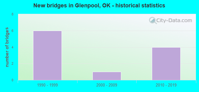
- New bridges - historical statistics
- 61990-1999
- 12000-2009
- 42010-2019


- Bridge Condition - Deck
- 50.0%Very good
- 50.0%Good

- Bridge Condition - Superstructure
- 50.0%Excellent
- 25.0%Very good
- 25.0%Satisfactory

- Bridge Condition - Substructure
- 75.0%Very good
- 25.0%Good

- Bridge Condition - Channel
- 25.0%Very good
- 62.5%Good
- 12.5%Satisfactory

- Bridge Condition - Culverts
- 20.0%Very good
- 40.0%Good
- 40.0%Satisfactory
Find on map >> Show street view
Structure Number: 8663, Location: 0.2 MI E OF US 75 (Lat: 35.980653, Lng: -96.008164), Route carried "on" structure: City street E0715, Year Built: 1992, Status: Open, Structure Length: 1.41m (4.63ft), Average Daily Traffic: 150 (year 2020), Truck Traffic: 10%, Average Future Daily Traffic: 240 (year 2040), Design Load: HS 20, Features Intersected: COAL CREEK
Minimum Vertical Clearance: 30+ m (98+ ft), Kilometerpoint: 0.322, Lanes on structure: 2, Owner: City or Municipal Highway Agency, Maintenance Responsibility: County Highway Agency, Approaching Roadway Width: 8.8m (28.9ft), Skew: 3 degrees, Material/Design: Concrete, Design/Construction: Culvert, Number Of Spans In Main Unit: 3, Length of Maximum Span: 4.3m (14.1ft), Curb-To-Curb Width: 9.1m (29.9ft), Out-to-Out Width: 9.8m (32.2ft)
Condition: Channel: Satisfactory, Culverts: Satisfactory, Operating Rating: 44.5 metric tons, Method Used To Determine Operating Rating: Allowable Stress (AS), Inventory Rating: 32.7 metric tons, Method Used To Determine Inventory Rating: Allowable Stress (AS), Structural Evaluation: Equal to present minimum criteria, Deck Geometry: Equal to present minimum criteria, Waterway Adequacy: Better than present minimum criteria, Approach Roadway Alignment: Equal to present desirable criteria, Length Of Structure Improvement: 3.52m (11.55ft), Designated Inspection Frequency: Every 24 months, Inspection Date: September 2021, Bridge Improvement Cost: $100,000, Roadway Improvement Cost: $75,000, Total Project Cost: $225,000 ( Estimate for 2015), Deck Structure Type: Concrete Cast-file-Place, Wearing Surface/Protective System: Wearing Surface: Bituminous
Find on map >> Show street view
Structure Number: 2275, Location: 2.8 MI E CREEK C/L (Lat: 35.944553, Lng: -95.980889), Route carried "on" structure: State highway 67, Year Built: 1991, Status: Open, Structure Length: 0.94m (3.08ft), Average Daily Traffic: 7,400 (year 2020), Truck Traffic: 5%, Average Future Daily Traffic: 11,840 (year 2040), Design Load: HS 20, Features Intersected: CREEK
Minimum Vertical Clearance: 30+ m (98+ ft), Kilometerpoint: 4.442, Lanes on structure: 4, Owner: State Highway Agency, Approaching Roadway Width: 13.4m (44.0ft), Skew: 3 degrees, Material/Design: Concrete, Design/Construction: Culvert, Number Of Spans In Main Unit: 2, Length of Maximum Span: 3.7m (12.1ft)
Condition: Channel: Good, Culverts: Good, Operating Rating: 54.4 metric tons, Method Used To Determine Operating Rating: Load Factor (LF), Inventory Rating: 32.7 metric tons, Method Used To Determine Inventory Rating: Load Factor (LF), Structural Evaluation: Better than present minimum criteria, Waterway Adequacy: Better than present minimum criteria, Approach Roadway Alignment: Equal to present desirable criteria, Length Of Structure Improvement: 0.94m (3.08ft), Designated Inspection Frequency: Every 24 months, Inspection Date: December 2020, Bridge Improvement Cost: $387,000, Roadway Improvement Cost: $639,000, Total Project Cost: $1,085,000 ( Estimate for 2015)
Find on map >> Show street view
Structure Number: 24389, Location: 1.4 MI E CREEK C/L (Lat: 35.944522, Lng: -96.005639), Route carried "on" structure: State highway 67, Year Built: 1994, Status: Open, Structure Length: 2.74m (8.99ft), Average Daily Traffic: 3,650 (year 2020), Truck Traffic: 5%, Average Future Daily Traffic: 5,840 (year 2040), Design Load: HS 20, Features Intersected: CREEK
Minimum Vertical Clearance: 30+ m (98+ ft), Kilometerpoint: 2.173, Lanes on structure: 2, Owner: State Highway Agency, Approaching Roadway Width: 13.4m (44.0ft), Skew: 10 degrees, Material/Design: Prestressed concrete, Design/Construction: Stringer/Multi-beam, Number Of Spans In Main Unit: 1, Length of Maximum Span: 27.4m (89.9ft), Curb-To-Curb Width: 11.6m (38.1ft), Out-to-Out Width: 12.2m (40.0ft)
Condition: Deck: Good, Superstructure: Very good, Substructure: Very good, Channel: Good, Operating Rating: 74.6 metric tons, Method Used To Determine Operating Rating: Load Factor (LF), Inventory Rating: 44.6 metric tons, Method Used To Determine Inventory Rating: Load Factor (LF), Structural Evaluation: Equal to present desirable criteria, Deck Geometry: Better than present minimum criteria, Waterway Adequacy: Better than present minimum criteria, Approach Roadway Alignment: Equal to present desirable criteria, Length Of Structure Improvement: 5.89m (19.32ft), Designated Inspection Frequency: Every 24 months, Inspection Date: December 2020, Bridge Improvement Cost: $755,000, Roadway Improvement Cost: $1,246,000, Total Project Cost: $2,115,000 ( Estimate for 2015), Deck Structure Type: Concrete Cast-file-Place, Wearing Surface/Protective System: Wearing Surface: Monolithic Concrete, Deck Protection: Bituminous
Find on map >> Show street view
Structure Number: 25338, Location: 6.08 MI N OF C/L (Lat: 35.944078, Lng: -96.012050), Route carried "on" structure: US 75, Year Built: 1996, Status: Open, Structure Length: 5.49m (18.01ft), Average Daily Traffic: 12,600 (year 2020), Truck Traffic: 7%, Average Future Daily Traffic: 20,160 (year 2040), Design Load: HS 20, Features Intersected: S.H. 67 UNDER
Minimum Vertical Clearance: 30+ m (98+ ft), Kilometerpoint: 9.783, Lanes on structure: 2, Lanes under structure: 6, Base Highway Network: Yes, Owner: State Highway Agency, Approaching Roadway Width: 11.0m (36.1ft), Skew: 10 degrees, Material/Design: Prestressed concrete, Design/Construction: Box Beam or Girders - Multiple, Number Of Spans In Main Unit: 1, Length of Maximum Span: 54.3m (178.1ft), Curb-To-Curb Width: 11.0m (36.1ft), Out-to-Out Width: 12.8m (42.0ft)
Condition: Deck: Good, Superstructure: Satisfactory, Substructure: Good, Operating Rating: 96.2 metric tons, Method Used To Determine Operating Rating: Load Factor (LF), Inventory Rating: 58.1 metric tons, Method Used To Determine Inventory Rating: Load Factor (LF), Structural Evaluation: Equal to present minimum criteria, Deck Geometry: Equal to present minimum criteria, Underclear: Equal to present minimum criteria, Approach Roadway Alignment: Equal to present desirable criteria, Length Of Structure Improvement: 8.40m (27.56ft), Designated Inspection Frequency: Every 24 months, Inspection Date: December 2020, Bridge Improvement Cost: $1,078,000, Roadway Improvement Cost: $1,778,000, Total Project Cost: $3,017,000 ( Estimate for 2015), Deck Structure Type: Concrete Cast-file-Place, Wearing Surface/Protective System: Wearing Surface: Monolithic Concrete
Find on map >> Show street view
Structure Number: 28127, Location: .8S OF 141ST ST. SOUTH (Lat: 35.948639, Lng: -95.976031), Route carried "on" structure: County highway 7282C, Year Built: 2004, Status: Open, Structure Length: 0.84m (2.76ft), Average Daily Traffic: 3,546 (year 2020), Truck Traffic: 10%, Average Future Daily Traffic: 5,674 (year 2040), Design Load: HS 20, Features Intersected: POSEY CREEK
Minimum Vertical Clearance: 30+ m (98+ ft), Kilometerpoint: 1.287, Lanes on structure: 2, Owner: County Highway Agency, Approaching Roadway Width: 8.3m (27.2ft), Skew: 2 degrees, Material/Design: Concrete, Design/Construction: Culvert, Number Of Spans In Main Unit: 2, Length of Maximum Span: 3.9m (12.8ft), Curb-To-Curb Width: 18.3m (60.0ft), Out-to-Out Width: 19.2m (63.0ft)
Condition: Channel: Good, Culverts: Satisfactory, Operating Rating: 42.6 metric tons, Method Used To Determine Operating Rating: Load Factor (LF), Inventory Rating: 32.7 metric tons, Method Used To Determine Inventory Rating: Load Factor (LF), Structural Evaluation: Equal to present minimum criteria, Deck Geometry: Superior to present desirable criteria, Waterway Adequacy: Equal to present minimum criteria, Approach Roadway Alignment: Equal to present desirable criteria, Length Of Structure Improvement: 0.86m (2.82ft), Designated Inspection Frequency: Every 24 months, Inspection Date: November 2021, Bridge Improvement Cost: $400,000, Roadway Improvement Cost: $600,000, Total Project Cost: $1,150,000 ( Estimate for 2015)
Find on map >> Show street view
Structure Number: 31318, Location: 4.5 S JCT HWY 67 (Lat: 35.876558, Lng: -96.015589), Route carried "on" structure: US 75, Year Built: 2017, Status: Open, Structure Length: 5.81m (19.06ft), Average Daily Traffic: 10,450 (year 2020), Truck Traffic: 25%, Average Future Daily Traffic: 16,720 (year 2040), Design Load: HL 93, Features Intersected: NORTH DUCK CREEK
Minimum Vertical Clearance: 30+ m (98+ ft), Kilometerpoint: 3.470, Lanes on structure: 2, Base Highway Network: Yes, Owner: State Highway Agency, Approaching Roadway Width: 11.6m (38.1ft), Skew: 10 degrees, Material/Design: Steel, Design/Construction: Stringer/Multi-beam, Number Of Spans In Main Unit: 3, Length of Maximum Span: 21.3m (69.9ft), Curb-To-Curb Width: 11.6m (38.1ft), Out-to-Out Width: 12.5m (41.0ft)
Condition: Deck: Very good, Superstructure: Excellent, Substructure: Very good, Channel: Very good, Operating Rating: 64.5 metric tons, Method Used To Determine Operating Rating: Load and Resistance Factor (LRFR), Inventory Rating: 49.7 metric tons, Method Used To Determine Inventory Rating: Load and Resistance Factor (LRFR), Structural Evaluation: Equal to present desirable criteria, Deck Geometry: Better than present minimum criteria, Waterway Adequacy: Equal to present desirable criteria, Approach Roadway Alignment: Equal to present desirable criteria, Designated Inspection Frequency: Every 24 months, Inspection Date: December 2020, Deck Structure Type: Concrete Cast-file-Place, Wearing Surface/Protective System: Wearing Surface: Monolithic Concrete, Membrane: Epoxy, Deck Protection: Epoxy Coated Reinforcing
Find on map >> Show street view
Structure Number: 31319, Location: 4.5 S OF JCT HWY 67 (Lat: 35.876383, Lng: -96.015242), Route carried "on" structure: US 75, Year Built: 2017, Status: Open, Structure Length: 6.16m (20.21ft), Average Daily Traffic: 10,300 (year 2020), Truck Traffic: 25%, Average Future Daily Traffic: 16,480 (year 2040), Design Load: HL 93, Features Intersected: NORTH DUCK CREEK
Minimum Vertical Clearance: 30+ m (98+ ft), Kilometerpoint: 2.157, Lanes on structure: 2, Base Highway Network: Yes, Owner: State Highway Agency, Approaching Roadway Width: 11.6m (38.1ft), Skew: 13 degrees, Material/Design: Steel, Design/Construction: Stringer/Multi-beam, Number Of Spans In Main Unit: 3, Length of Maximum Span: 24.4m (80.1ft), Curb-To-Curb Width: 11.6m (38.1ft), Out-to-Out Width: 12.5m (41.0ft)
Condition: Deck: Very good, Superstructure: Excellent, Substructure: Very good, Channel: Very good, Operating Rating: 56.9 metric tons, Method Used To Determine Operating Rating: Load and Resistance Factor (LRFR), Inventory Rating: 43.8 metric tons, Method Used To Determine Inventory Rating: Load and Resistance Factor (LRFR), Structural Evaluation: Equal to present desirable criteria, Deck Geometry: Better than present minimum criteria, Waterway Adequacy: Equal to present desirable criteria, Approach Roadway Alignment: Equal to present desirable criteria, Designated Inspection Frequency: Every 24 months, Inspection Date: December 2020, Deck Structure Type: Concrete Cast-file-Place, Wearing Surface/Protective System: Wearing Surface: Monolithic Concrete, Membrane: Epoxy, Deck Protection: Epoxy Coated Reinforcing
Find on map >> Show street view
Structure Number: 31549, Location: .5S OF 141ST S. (Lat: 35.952253, Lng: -95.958161), Route carried "on" structure: County highway N3960, Year Built: 2016, Status: Open, Structure Length: 0.91m (2.99ft), Average Daily Traffic: 2,058 (year 2020), Truck Traffic: 15%, Average Future Daily Traffic: 3,293 (year 2040), Design Load: HS 20, Features Intersected: POSEY CREEK
Minimum Vertical Clearance: 30+ m (98+ ft), Kilometerpoint: 0.805, Lanes on structure: 2, Owner: County Highway Agency, Approaching Roadway Width: 7.3m (24.0ft), Material/Design: Concrete, Design/Construction: Culvert, Number Of Spans In Main Unit: 2, Length of Maximum Span: 4.4m (14.4ft), Curb-To-Curb Width: 9.7m (31.8ft), Out-to-Out Width: 10.4m (34.1ft)
Condition: Channel: Good, Culverts: Good, Operating Rating: 44.5 metric tons, Method Used To Determine Operating Rating: Allowable Stress (AS), Inventory Rating: 32.7 metric tons, Method Used To Determine Inventory Rating: Allowable Stress (AS), Structural Evaluation: Better than present minimum criteria, Deck Geometry: Meets minimum limits, Waterway Adequacy: Equal to present desirable criteria, Approach Roadway Alignment: Equal to present desirable criteria, Designated Inspection Frequency: Every 24 months, Inspection Date: September 2020, Total Project Cost: $225,000, Deck Structure Type: Concrete Cast-file-Place, Wearing Surface/Protective System: Wearing Surface: Monolithic Concrete
Find on map >> Show street view
Structure Number: 32534, Location: .2NE OF US 75/SH67 (Lat: 35.946919, Lng: -96.008933), Route carried "on" structure: City street N3932, Year Built: 2019, Status: Open, Structure Length: 1.34m (4.40ft), Average Daily Traffic: 40 (year 2020), Truck Traffic: 10%, Average Future Daily Traffic: 64 (year 2040), Design Load: HL 93, Features Intersected: CREEK
Minimum Vertical Clearance: 30+ m (98+ ft), Kilometerpoint: 2.071, Lanes on structure: 3, Owner: City or Municipal Highway Agency, Approaching Roadway Width: 11.0m (36.1ft), Material/Design: Concrete, Design/Construction: Culvert, Number Of Spans In Main Unit: 3, Length of Maximum Span: 4.3m (14.1ft), Curb-To-Curb Width: 11.0m (36.1ft), Out-to-Out Width: 30.6m (100.4ft)
Condition: Channel: Good, Culverts: Very good, Operating Rating: 42.6 metric tons, Method Used To Determine Operating Rating: Load and Resistance Factor (LRFR), Inventory Rating: 32.7 metric tons, Method Used To Determine Inventory Rating: Load and Resistance Factor (LRFR), Structural Evaluation: Equal to present desirable criteria, Deck Geometry: High priority of replacement, Waterway Adequacy: Superior to present desirable criteria, Approach Roadway Alignment: Equal to present desirable criteria, Designated Inspection Frequency: Every 24 months, Inspection Date: September 2021, Deck Structure Type: Concrete Cast-file-Place, Wearing Surface/Protective System: Wearing Surface: Bituminous
Find on map >> Show street view
Structure Number: 25337, Location: 6.08 MI N OF C/L (Lat: 35.944078, Lng: -96.011686), Route carried "under" structure: State highway 67, Year Built: 1996, Structure Length: 0. m, Average Daily Traffic: 7,100 (year 2020), Truck Traffic: 16%, Features Intersected: S.H. 67 UNDER, Facility Carried by Structure: U.S. 75 NB
Minimum Vertical Clearance: 5.18m (16.99ft), Kilometerpoint: 1.593, Lanes on structure: 2, Lanes under structure: 6, Material/Design: Prestressed concrete, Design/Construction: Box Beam or Girders - Multiple, Length of Maximum Span: 54.3m (178.1ft)
Find on map >> Show street view
Structure Number: 25338, Location: 6.08 MI N OF C/L (Lat: 35.944078, Lng: -96.012050), Route carried "under" structure: State highway 67, Year Built: 1996, Structure Length: 0. m, Average Daily Traffic: 7,100 (year 2020), Truck Traffic: 16%, Features Intersected: S.H. 67 UNDER, Facility Carried by Structure: U.S. 75 SB
Minimum Vertical Clearance: 5.08m (16.67ft), Kilometerpoint: 1.577, Lanes on structure: 2, Lanes under structure: 6, Material/Design: Prestressed concrete, Design/Construction: Box Beam or Girders - Multiple, Length of Maximum Span: 54.3m (178.1ft)