Bridge Statistics for Fitchburg, Massachusetts (MA)
Condition, Traffic, Stress, Structural Evaluation, Project Costs
- National Bridge Inventory (NBI) Statistics
- 49Number of bridges
- 394ft / 120mTotal length
- $102,422,000Total costs
- 452,279Total average daily traffic
- 40,580Total average daily truck traffic
- 867,781Total future (year 2031) average daily traffic
- National Bridge Inventory (NBI) Registered Bridges for Fitchburg
- No street view available for this location
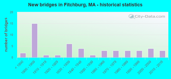
- New bridges - historical statistics
- 2Before 1900
- 151900-1909
- 11910-1919
- 11920-1929
- 61930-1939
- 41940-1949
- 11950-1959
- 31960-1969
- 31970-1979
- 31980-1989
- 31990-1999
- 42000-2009
- 32010-2019

- Reconstructed bridges - Historical Statistics
- 41920-1929
- 11930-1939
- 21940-1949
- 21950-1959
- 01960-1969
- 01970-1979
- 41980-1989
- 21990-1999
- 12000-2009
- 02010-2019
- 12020-2022


- Bridge Condition - Deck
- 6.9%Very good
- 31.0%Good
- 24.1%Satisfactory
- 24.1%Fair
- 10.3%Poor
- 3.4%Serious

- Bridge Condition - Superstructure
- 6.8%Very good
- 27.3%Good
- 31.8%Satisfactory
- 20.5%Fair
- 11.4%Poor
- 2.3%Critical

- Bridge Condition - Substructure
- 6.8%Very good
- 34.1%Good
- 38.6%Satisfactory
- 13.6%Fair
- 6.8%Poor

- Bridge Condition - Channel
- 4.5%Very good
- 38.6%Good
- 34.1%Satisfactory
- 13.6%Fair
- 9.1%Poor

- Bridge Condition - Culverts
- 40.0%Good
- 60.0%Satisfactory
Find on map >> Show street view
Structure Number: F0400120PDOTNBI, Location: 0.1 MI S OF ST-2A (Lat: 42.563000, Lng: -71.846347), Route carried "on" structure: Alternate State highway 31, Year Built: 1929, Status: Open, Structure Length: 1.22m (4.00ft), Average Daily Traffic: 6,126 (year 2020), Truck Traffic: 6%, Average Future Daily Traffic: 9,160 (year 2032), Design Load: H 20, Features Intersected: WATER WHITMANS RIVER
Minimum Vertical Clearance: 30+ m (98+ ft), Kilometerpoint: 75.470, Lanes on structure: 2, Owner: State Highway Agency, Approaching Roadway Width: 8.6m (28.2ft), Material/Design: Masonry, Design/Construction: Arch - Deck, Number Of Spans In Main Unit: 1, Length of Maximum Span: 10.6m (34.8ft), Curb or Sidewalk Widths: Left: 0.6m (2.0ft), Right: 1.9m (6.2ft), Curb-To-Curb Width: 9.3m (30.5ft), Out-to-Out Width: 11.9m (39.0ft)
Condition: Superstructure: Satisfactory, Substructure: Fair, Channel: Good, Structural Evaluation: Somewhat better than minimum adequacy, Deck Geometry: High priority of corrective action, Waterway Adequacy: Equal to present desirable criteria, Approach Roadway Alignment: Equal to present desirable criteria, Length Of Structure Improvement: 1.30m (4.27ft), Designated Inspection Frequency: Every 24 months, Inspection Date: June 2021, Bridge Improvement Cost: $608,000, Roadway Improvement Cost: $61,000, Total Project Cost: $913,000 ( Estimate for 2022)
Find on map >> Show street view
Structure Number: F040021P7DOTNBI, Location: 50 FT WEST OF ST-31 (Lat: 42.549844, Lng: -71.847933), Route carried "on" structure: State highway 2, Year Built: 1947, Status: Open, Structure Length: 1.19m (3.90ft), Average Daily Traffic: 49,532 (year 2016), Truck Traffic: 10%, Average Future Daily Traffic: 71,068 (year 2032), Design Load: H 20, Features Intersected: WATER WYMAN BROOK
Minimum Vertical Clearance: 30+ m (98+ ft), Kilometerpoint: 152.306, Lanes on structure: 5, Base Highway Network: Yes, Owner: State Highway Agency, Approaching Roadway Width: 25.6m (84.0ft), Skew: 32 degrees, Material/Design: Concrete, Design/Construction: Tee Beam, Number Of Spans In Main Unit: 1, Length of Maximum Span: 8.8m (28.9ft), Curb-To-Curb Width: 25.6m (84.0ft), Out-to-Out Width: 29.9m (98.1ft)
Condition: Deck: Fair, Superstructure: Poor, Substructure: Poor, Channel: Poor, Operating Rating: 73.1 metric tons, Method Used To Determine Operating Rating: Load Factor (LF), Inventory Rating: 44.0 metric tons, Method Used To Determine Inventory Rating: Load Factor (LF), Structural Evaluation: Meets minimum limits, Deck Geometry: Better than present minimum criteria, Waterway Adequacy: Equal to present minimum criteria, Approach Roadway Alignment: Equal to present desirable criteria, Length Of Structure Improvement: 1.20m (3.94ft), Designated Inspection Frequency: Every 12 months, Other Special Inspection Frequency: Every 12 months, Inspection Date: September 2021, Other Special Inspection Date: September 2021, Bridge Improvement Cost: $1,410,000, Roadway Improvement Cost: $142,000, Total Project Cost: $2,116,000 ( Estimate for 2022), Deck Structure Type: Concrete Cast-file-Place, Wearing Surface/Protective System: Wearing Surface: Bituminous, Membrane: Built-up
Find on map >> Show street view
Structure Number: F040031KUDOTNBI, Location: .1 MI W OF ST-12 (Lat: 42.574528, Lng: -71.837172), Route carried "on" structure: State highway 31, Year Built: 1947, Year Reconstructed: 2020, Status: Open, Structure Length: 1.75m (5.74ft), Average Daily Traffic: 10,684 (year 2019), Truck Traffic: 3%, Average Future Daily Traffic: 23,690 (year 2032), Design Load: HL 93, Features Intersected: WATER PHILLIPS BROOK
Minimum Vertical Clearance: 30+ m (98+ ft), Kilometerpoint: 76.989, Lanes on structure: 2, Base Highway Network: Yes, Owner: State Highway Agency, Approaching Roadway Width: 10.3m (33.8ft), Skew: 1 degrees, Material/Design: Steel, Design/Construction: Stringer/Multi-beam, Number Of Spans In Main Unit: 1, Length of Maximum Span: 17.1m (56.1ft), Curb or Sidewalk Widths: Left: 2.4m (7.9ft), Right: 2.3m (7.5ft), Curb-To-Curb Width: 11.0m (36.1ft), Out-to-Out Width: 16.6m (54.5ft)
Condition: Deck: Very good, Superstructure: Very good, Substructure: Satisfactory, Channel: Fair, Operating Rating: 97.2 metric tons, Method Used To Determine Operating Rating: Load and Resistance Factor Rating (LRFR) rating reported by rating factor(RF) method using HL-93 loadings, Inventory Rating: 77.8 metric tons, Method Used To Determine Inventory Rating: Load and Resistance Factor Rating (LRFR) rating reported by rating factor(RF) method using HL-93 loadings, Structural Evaluation: Equal to present minimum criteria, Deck Geometry: Meets minimum limits, Waterway Adequacy: Better than present minimum criteria, Approach Roadway Alignment: Equal to present desirable criteria, Designated Inspection Frequency: Every 24 months, Underwater Inspection Frequency: Every 28 months, Inspection Date: September 2020, Underwater Inspection Date: November 2020, Deck Structure Type: Concrete Cast-file-Place, Wearing Surface/Protective System: Wearing Surface: Bituminous, Membrane: Built-up, Deck Protection: Epoxy Coated Reinforcing
Find on map >> Show street view
Structure Number: F040041EHMUNNBI, Location: AT JCT OF RTE 2A (Lat: 42.575278, Lng: -71.834508), Route carried "on" structure: City street , Year Built: 1908, Status: Open, Structure Length: 2.13m (6.99ft), Average Daily Traffic: 4,455 (year 2018), Truck Traffic: 3%, Average Future Daily Traffic: 11,529 (year 2032), Features Intersected: WATER N NASHUA RIVER, Facility Carried by Structure: HWY DEPOT ST
Minimum Vertical Clearance: 30+ m (98+ ft), Kilometerpoint: 0.628, Lanes on structure: 2, Owner: City or Municipal Highway Agency, Approaching Roadway Width: 10.4m (34.1ft), Material/Design: Masonry, Design/Construction: Arch - Deck, Number Of Spans In Main Unit: 1, Length of Maximum Span: 21.3m (69.9ft), Curb or Sidewalk Widths: Left: 2.0m (6.6ft), Right: 2.0m (6.6ft), Curb-To-Curb Width: 10.5m (34.4ft), Out-to-Out Width: 15.5m (50.9ft)
Condition: Superstructure: Good, Substructure: Good, Channel: Satisfactory, Structural Evaluation: Better than present minimum criteria, Deck Geometry: Somewhat better than minimum adequacy, Waterway Adequacy: Equal to present minimum criteria, Approach Roadway Alignment: Meets minimum limits, Length Of Structure Improvement: 2.20m (7.22ft), Designated Inspection Frequency: Every 24 months, Inspection Date: May 2021, Bridge Improvement Cost: $602,000, Roadway Improvement Cost: $61,000, Total Project Cost: $904,000 ( Estimate for 2022)
Find on map >> Show street view
Structure Number: F040051ENMUNNBI, Location: AT JCT OF RTE 31 (Lat: 42.581181, Lng: -71.822036), Route carried "on" structure: City street , Year Built: 1900, Year Reconstructed: 1986, Status: Posted for load, Structure Length: 2.65m (8.69ft), Average Daily Traffic: 1,306 (year 2019), Truck Traffic: 5%, Average Future Daily Traffic: 5,528 (year 2032), Design Load: H 20, Features Intersected: WATER N NASHUA RIVER, Facility Carried by Structure: HWY OAK HILL RD
Minimum Vertical Clearance: 30+ m (98+ ft), Kilometerpoint: 3.878, Lanes on structure: 2, Owner: City or Municipal Highway Agency, Approaching Roadway Width: 7.7m (25.3ft), Material/Design: Steel, Design/Construction: Stringer/Multi-beam, Number Of Spans In Main Unit: 2, Length of Maximum Span: 12.5m (41.0ft), Curb or Sidewalk Widths: Left: 2.3m (7.5ft), Right: 2.3m (7.5ft), Curb-To-Curb Width: 8.1m (26.6ft), Out-to-Out Width: 15.4m (50.5ft)
Condition: Deck: Good, Superstructure: Poor, Substructure: Good, Channel: Fair, Operating Rating: 36.4 metric tons, Method Used To Determine Operating Rating: Load Factor (LF), Inventory Rating: 21.8 metric tons, Method Used To Determine Inventory Rating: Load Factor (LF), Structural Evaluation: Meets minimum limits, Deck Geometry: Meets minimum limits, Waterway Adequacy: Better than present minimum criteria, Approach Roadway Alignment: Equal to present minimum criteria, Length Of Structure Improvement: 3.60m (11.81ft), Designated Inspection Frequency: Every 12 months, Other Special Inspection Frequency: Every 12 months, Inspection Date: March 2021, Other Special Inspection Date: March 2022, Bridge Improvement Cost: $3,904,000, Roadway Improvement Cost: $391,000, Total Project Cost: $5,857,000 ( Estimate for 2022), Deck Structure Type: Concrete Cast-file-Place, Wearing Surface/Protective System: Wearing Surface: Bituminous, Membrane: Built-up
Find on map >> Show street view
Structure Number: F040061EJMUNNBI, Location: AT ROTARY OF 12 AND 2A (Lat: 42.581700, Lng: -71.818617), Route carried "on" structure: City street , Year Built: 1906, Year Reconstructed: 1989, Status: Open, Structure Length: 2.74m (8.99ft), Average Daily Traffic: 10,300 (year 2014), Truck Traffic: 6%, Average Future Daily Traffic: 16,267 (year 2031), Design Load: HS 20, Features Intersected: WATER N NASHUA RIVER, Facility Carried by Structure: HWY DANIELS ST
Minimum Vertical Clearance: 30+ m (98+ ft), Kilometerpoint: 0.949, Lanes on structure: 2, Owner: City or Municipal Highway Agency, Approaching Roadway Width: 11.6m (38.1ft), Material/Design: Steel continuous, Design/Construction: Stringer/Multi-beam, Number Of Spans In Main Unit: 2, Length of Maximum Span: 12.8m (42.0ft), Curb or Sidewalk Widths: Left: 1.9m (6.2ft), Right: 2.0m (6.6ft), Curb-To-Curb Width: 11.6m (38.1ft), Out-to-Out Width: 16.2m (53.1ft)
Condition: Deck: Satisfactory, Superstructure: Good, Substructure: Satisfactory, Channel: Satisfactory, Operating Rating: 58.9 metric tons, Method Used To Determine Operating Rating: Allowable Stress (AS), Inventory Rating: 29.1 metric tons, Method Used To Determine Inventory Rating: Allowable Stress (AS), Structural Evaluation: Equal to present minimum criteria, Deck Geometry: Somewhat better than minimum adequacy, Waterway Adequacy: Better than present minimum criteria, Approach Roadway Alignment: Equal to present desirable criteria, Length Of Structure Improvement: 2.80m (9.19ft), Designated Inspection Frequency: Every 24 months, Inspection Date: July 2020, Bridge Improvement Cost: $1,782,000, Roadway Improvement Cost: $179,000, Total Project Cost: $2,674,000 ( Estimate for 2022), Deck Structure Type: Concrete Cast-file-Place, Wearing Surface/Protective System: Wearing Surface: Bituminous, Membrane: Built-up, Deck Protection: Epoxy Coated Reinforcing
Find on map >> Show street view
Structure Number: F04007B90DOTNBI, Location: 200 FT. EAST OF ROTARY (Lat: 42.583050, Lng: -71.817944), Route carried "on" structure: Alternate State highway 20, Year Built: 2014, Status: Open, Structure Length: 3.31m (10.86ft), Average Daily Traffic: 6,351 (year 2019), Truck Traffic: 5%, Design Load: HS 20, Features Intersected: WATER N NASHUA RIVER, Facility Carried by Structure: ST 2 A/ST12/KIMBL
Minimum Vertical Clearance: 30+ m (98+ ft), Kilometerpoint: 0.161, Lanes on structure: 2, Owner: State Highway Agency, Approaching Roadway Width: 10.7m (35.1ft), Material/Design: Prestressed concrete, Design/Construction: Box Beam or Girders - Single/Spread, Number Of Spans In Main Unit: 1, Length of Maximum Span: 32.0m (105.0ft), Curb or Sidewalk Widths: Left: 1.7m (5.6ft), Right: 1.7m (5.6ft), Curb-To-Curb Width: 10.7m (35.1ft), Out-to-Out Width: 15.0m (49.2ft)
Condition: Deck: Good, Superstructure: Very good, Substructure: Good, Channel: Good, Operating Rating: 74.5 metric tons, Method Used To Determine Operating Rating: Load and Resistance Factor Rating (LRFR) rating reported by rating factor(RF) method using HL-93 loadings, Inventory Rating: 61.6 metric tons, Method Used To Determine Inventory Rating: Load and Resistance Factor Rating (LRFR) rating reported by rating factor(RF) method using HL-93 loadings, Structural Evaluation: Better than present minimum criteria, Deck Geometry: Meets minimum limits, Waterway Adequacy: Equal to present desirable criteria, Approach Roadway Alignment: Equal to present desirable criteria, Designated Inspection Frequency: Every 24 months, Inspection Date: December 2020, Deck Structure Type: Concrete Cast-file-Place, Wearing Surface/Protective System: Wearing Surface: Bituminous, Membrane: Preformed Fabric, Deck Protection: Epoxy Coated Reinforcing
Find on map >> Show street view
Structure Number: F040081KTDOTNBI, Location: 100 FT E OF WALLACE ST (Lat: 42.583583, Lng: -71.818328), Route carried "on" structure: State highway 31, Year Built: 1947, Year Reconstructed: 2014, Status: Open, Structure Length: 2.93m (9.61ft), Average Daily Traffic: 10,088 (year 2018), Truck Traffic: 3%, Average Future Daily Traffic: 23,690 (year 2031), Design Load: HL 93, Features Intersected: WATER N NASHUA RIVER
Minimum Vertical Clearance: 30+ m (98+ ft), Kilometerpoint: 75.476, Lanes on structure: 2, Base Highway Network: Yes, Owner: State Highway Agency, Approaching Roadway Width: 11.0m (36.1ft), Skew: 2 degrees, Material/Design: Steel continuous, Design/Construction: Stringer/Multi-beam, Number Of Spans In Main Unit: 2, Length of Maximum Span: 13.7m (44.9ft), Curb or Sidewalk Widths: Left: 2.0m (6.6ft), Right: 3.0m (9.8ft), Curb-To-Curb Width: 11.0m (36.1ft), Out-to-Out Width: 16.8m (55.1ft)
Condition: Deck: Good, Superstructure: Good, Substructure: Good, Channel: Fair, Operating Rating: 45.4 metric tons, Method Used To Determine Operating Rating: Load and Resistance Factor Rating (LRFR) rating reported by rating factor(RF) method using HL-93 loadings, Inventory Rating: 35.6 metric tons, Method Used To Determine Inventory Rating: Load and Resistance Factor Rating (LRFR) rating reported by rating factor(RF) method using HL-93 loadings, Structural Evaluation: Better than present minimum criteria, Deck Geometry: Meets minimum limits, Waterway Adequacy: Equal to present desirable criteria, Approach Roadway Alignment: Better than present minimum criteria, Designated Inspection Frequency: Every 24 months, Inspection Date: September 2021, Deck Structure Type: Concrete Cast-file-Place, Wearing Surface/Protective System: Wearing Surface: Bituminous, Membrane: Built-up, Deck Protection: Epoxy Coated Reinforcing
Find on map >> Show street view
Structure Number: F040091JRMUNNBI, Location: .1MI. N. OF ST-31RIVER ST (Lat: 42.586339, Lng: -71.816014), Route carried "on" structure: City street , Year Built: 1900, Year Reconstructed: 1988, Status: Open, Structure Length: 2.35m (7.71ft), Average Daily Traffic: 650 (year 2014), Truck Traffic: 3%, Average Future Daily Traffic: 1,027 (year 2033), Design Load: HS 20, Features Intersected: WATER N NASHUA RIVER, Facility Carried by Structure: HWY SHELDON ST
Minimum Vertical Clearance: 30+ m (98+ ft), Kilometerpoint: 0.161, Lanes on structure: 2, Owner: City or Municipal Highway Agency, Approaching Roadway Width: 7.9m (25.9ft), Skew: 3 degrees, Material/Design: Steel, Design/Construction: Stringer/Multi-beam, Number Of Spans In Main Unit: 1, Length of Maximum Span: 22.6m (74.1ft), Curb or Sidewalk Widths: Left: 1.5m (4.9ft), Right: 1.5m (4.9ft), Curb-To-Curb Width: 7.9m (25.9ft), Out-to-Out Width: 11.9m (39.0ft)
Condition: Deck: Satisfactory, Superstructure: Good, Substructure: Satisfactory, Channel: Good, Operating Rating: 78.7 metric tons, Method Used To Determine Operating Rating: Load Factor (LF), Inventory Rating: 47.2 metric tons, Method Used To Determine Inventory Rating: Load Factor (LF), Structural Evaluation: Equal to present minimum criteria, Deck Geometry: Somewhat better than minimum adequacy, Waterway Adequacy: Equal to present desirable criteria, Approach Roadway Alignment: Equal to present desirable criteria, Length Of Structure Improvement: 2.40m (7.87ft), Designated Inspection Frequency: Every 24 months, Inspection Date: March 2020, Bridge Improvement Cost: $974,000, Roadway Improvement Cost: $98,000, Total Project Cost: $1,462,000 ( Estimate for 2022), Deck Structure Type: Concrete Cast-file-Place, Wearing Surface/Protective System: Wearing Surface: Bituminous, Membrane: Built-up, Deck Protection: Epoxy Coated Reinforcing
Find on map >> Show street view
Structure Number: F040101KRDOTNBI, Location: EAST OF BROAD STREET (Lat: 42.586922, Lng: -71.808969), Route carried "on" structure: State highway 31, Year Built: 1900, Year Reconstructed: 1952, Status: Open, Structure Length: 2.77m (9.09ft), Average Daily Traffic: 10,128 (year 2019), Truck Traffic: 5%, Average Future Daily Traffic: 23,690 (year 2031), Design Load: H 20, Features Intersected: WATER N NASHUA RIVER
Minimum Vertical Clearance: 30+ m (98+ ft), Kilometerpoint: 80.339, Lanes on structure: 2, Base Highway Network: Yes, Owner: State Highway Agency, Approaching Roadway Width: 10.4m (34.1ft), Skew: 2 degrees, Material/Design: Steel continuous, Design/Construction: Stringer/Multi-beam, Number Of Spans In Main Unit: 2, Length of Maximum Span: 13.4m (44.0ft), Curb or Sidewalk Widths: Left: 2.0m (6.6ft), Right: 2.0m (6.6ft), Curb-To-Curb Width: 10.3m (33.8ft), Out-to-Out Width: 15.2m (49.9ft)
Condition: Deck: Fair, Superstructure: Fair, Substructure: Satisfactory, Channel: Fair, Operating Rating: 38.1 metric tons, Method Used To Determine Operating Rating: Load Factor (LF), Inventory Rating: 22.8 metric tons, Method Used To Determine Inventory Rating: Load Factor (LF), Structural Evaluation: Somewhat better than minimum adequacy, Deck Geometry: Meets minimum limits, Waterway Adequacy: Equal to present desirable criteria, Approach Roadway Alignment: Equal to present minimum criteria, Length Of Structure Improvement: 2.80m (9.19ft), Designated Inspection Frequency: Every 24 months, Inspection Date: August 2020, Bridge Improvement Cost: $1,672,000, Roadway Improvement Cost: $168,000, Total Project Cost: $2,509,000 ( Estimate for 2022), Deck Structure Type: Concrete Cast-file-Place, Wearing Surface/Protective System: Wearing Surface: Bituminous, Membrane: Built-up
Find on map >> Show street view
Structure Number: F040111JTMUNNBI, Location: 0.1 MI S OF ST-31 (Lat: 42.585653, Lng: -71.806453), Route carried "on" structure: City street , Year Built: 1937, Status: Closed, Structure Length: 2.44m (8.01ft), Average Daily Traffic: 800 (year 2014), Truck Traffic: 6%, Average Future Daily Traffic: 1,263 (year 2031), Design Load: H 20, Features Intersected: WATER N NASHUA RIVER, Facility Carried by Structure: HWY CIRCLE ST
Minimum Vertical Clearance: 30+ m (98+ ft), Kilometerpoint: 0.161, Lanes on structure: 2, Owner: City or Municipal Highway Agency, Approaching Roadway Width: 7.9m (25.9ft), Skew: 1 degrees, Material/Design: Steel, Design/Construction: Stringer/Multi-beam, Number Of Spans In Main Unit: 1, Length of Maximum Span: 22.9m (75.1ft), Curb or Sidewalk Widths: Left: 0.2m (0.7ft), Right: 2.0m (6.6ft), Curb-To-Curb Width: 9.1m (29.9ft), Out-to-Out Width: 11.7m (38.4ft)
Condition: Deck: Serious, Superstructure: Fair, Substructure: Satisfactory, Channel: Satisfactory, Operating Rating: 46.7 metric tons, Method Used To Determine Operating Rating: Load Factor (LF), Inventory Rating: 27.9 metric tons, Method Used To Determine Inventory Rating: Load Factor (LF), Structural Evaluation: Somewhat better than minimum adequacy, Deck Geometry: Meets minimum limits, Waterway Adequacy: Equal to present minimum criteria, Approach Roadway Alignment: Better than present minimum criteria, Length Of Structure Improvement: 2.50m (8.20ft), Designated Inspection Frequency: Every 11 months, Inspection Date: November 2020, Bridge Improvement Cost: $1,149,000, Roadway Improvement Cost: $115,000, Total Project Cost: $1,724,000 ( Estimate for 2022), Deck Structure Type: Concrete Cast-file-Place, Wearing Surface/Protective System: Wearing Surface: Bituminous, Membrane: Built-up
Find on map >> Show street view
Structure Number: F0401220MDOTNBI, Location: .2 MI. S. OF MAIN ST. (Lat: 42.584356, Lng: -71.806583), Route carried "on" structure: State highway 31, Year Built: 1909, Year Reconstructed: 1997, Status: Open, Structure Length: 5.39m (17.68ft), Average Daily Traffic: 3,100 (year 2013), Truck Traffic: 2%, Average Future Daily Traffic: 4,896 (year 2032), Design Load: HS 20, Features Intersected: WATER N NASHUA RIVER
Minimum Vertical Clearance: 30+ m (98+ ft), Kilometerpoint: 0.322, Lanes on structure: 2, Owner: State Highway Agency, Approaching Roadway Width: 7.9m (25.9ft), Material/Design: Steel, Design/Construction: Truss - Deck, Number Of Spans In Main Unit: 2, Length of Maximum Span: 26.2m (86.0ft), Curb or Sidewalk Widths: Left: 1.6m (5.2ft), Right: 1.6m (5.2ft), Curb-To-Curb Width: 8.6m (28.2ft), Out-to-Out Width: 12.3m (40.4ft)
Condition: Deck: Good, Superstructure: Poor, Substructure: Satisfactory, Channel: Good, Operating Rating: 40.8 metric tons, Method Used To Determine Operating Rating: Load Factor (LF), Inventory Rating: 31.8 metric tons, Method Used To Determine Inventory Rating: Load Factor (LF), Structural Evaluation: Meets minimum limits, Deck Geometry: Meets minimum limits, Waterway Adequacy: Equal to present desirable criteria, Approach Roadway Alignment: Better than present minimum criteria, Length Of Structure Improvement: 6.50m (21.33ft), Designated Inspection Frequency: Every 12 months, Critical Feature Inspection Frequency: Every 24 months, Other Special Inspection Frequency: Every 12 months, Inspection Date: August 2021, Critical Feature Inspection Date: August 2021, Other Special Inspection Date: August 2021, Bridge Improvement Cost: $5,823,000, Roadway Improvement Cost: $583,000, Total Project Cost: $8,735,000 ( Estimate for 2022), Deck Structure Type: Concrete Cast-file-Place, Wearing Surface/Protective System: Wearing Surface: Latex Concrete, Membrane: Built-up, Deck Protection: Epoxy Coated Reinforcing
Find on map >> Show street view
Structure Number: F0401220NDOTNBI, Location: .2 MI. SOUTH OF MAIN ST (Lat: 42.584142, Lng: -71.806839), Route carried "on" structure: State highway 31, Year Built: 1997, Status: Open, Structure Length: 2.42m (7.94ft), Average Daily Traffic: 2,813 (year 2013), Truck Traffic: 4%, Average Future Daily Traffic: 15,003 (year 2031), Design Load: H 20, Features Intersected: HWY BROAD ST
Minimum Vertical Clearance: 30+ m (98+ ft), Kilometerpoint: 0.322, Lanes on structure: 2, Lanes under structure: 2, Owner: State Highway Agency, Approaching Roadway Width: 7.1m (23.3ft), Material/Design: Prestressed concrete, Design/Construction: Box Beam or Girders - Single/Spread, Number Of Spans In Main Unit: 1, Length of Maximum Span: 23.0m (75.5ft), Curb or Sidewalk Widths: Left: 1.6m (5.2ft), Right: 1.6m (5.2ft), Curb-To-Curb Width: 8.6m (28.2ft), Out-to-Out Width: 12.3m (40.4ft)
Condition: Deck: Satisfactory, Superstructure: Satisfactory, Substructure: Good, Operating Rating: 57.1 metric tons, Method Used To Determine Operating Rating: Allowable Stress (AS), Inventory Rating: 51.3 metric tons, Method Used To Determine Inventory Rating: Allowable Stress (AS), Structural Evaluation: Equal to present minimum criteria, Deck Geometry: Meets minimum limits, Underclear: High priority of corrective action, Approach Roadway Alignment: Better than present minimum criteria, Length Of Structure Improvement: 2.50m (8.20ft), Designated Inspection Frequency: Every 24 months, Inspection Date: October 2020, Bridge Improvement Cost: $1,132,000, Roadway Improvement Cost: $114,000, Total Project Cost: $1,699,000 ( Estimate for 2022), Deck Structure Type: Concrete Precast Panels, Wearing Surface/Protective System: Wearing Surface: Bituminous, Membrane: Built-up
Find on map >> Show street view
Structure Number: F040141EKMUNNBI, Location: AT BOULDER ST & PUTNAM ST (Lat: 42.581472, Lng: -71.800003), Route carried "on" structure: City street , Year Built: 1900, Status: Open, Structure Length: 2.90m (9.51ft), Average Daily Traffic: 5,261 (year 2017), Truck Traffic: 6%, Average Future Daily Traffic: 22,110 (year 2031), Features Intersected: WATER N NASHUA RIVER, Facility Carried by Structure: HWY PUTNAM ST
Minimum Vertical Clearance: 30+ m (98+ ft), Kilometerpoint: 0.097, Lanes on structure: 2, Owner: City or Municipal Highway Agency, Approaching Roadway Width: 7.9m (25.9ft), Skew: 2 degrees, Material/Design: Masonry, Design/Construction: Arch - Deck, Number Of Spans In Main Unit: 2, Length of Maximum Span: 13.4m (44.0ft), Curb or Sidewalk Widths: Left: 1.5m (4.9ft), Right: 1.5m (4.9ft), Curb-To-Curb Width: 7.9m (25.9ft), Out-to-Out Width: 12.5m (41.0ft)
Condition: Superstructure: Satisfactory, Substructure: Satisfactory, Channel: Satisfactory, Structural Evaluation: Equal to present minimum criteria, Deck Geometry: High priority of replacement, Waterway Adequacy: Equal to present desirable criteria, Approach Roadway Alignment: Equal to present minimum criteria, Length Of Structure Improvement: 3.00m (9.84ft), Designated Inspection Frequency: Every 24 months, Inspection Date: June 2020, Bridge Improvement Cost: $1,556,000, Roadway Improvement Cost: $156,000, Total Project Cost: $2,335,000 ( Estimate for 2022)
Find on map >> Show street view
Structure Number: F040151JUMUNNBI, Location: 0.1 MI. E. OF PUTNAM ST. (Lat: 42.581433, Lng: -71.797628), Route carried "on" structure: City street , Year Built: 1939, Status: Posted for load, Structure Length: 2.98m (9.78ft), Average Daily Traffic: 130 (year 2019), Truck Traffic: 1%, Average Future Daily Traffic: 205 (year 2031), Design Load: H 20, Features Intersected: WATER NASHUA RIVER, Facility Carried by Structure: HWY COMMRCIAL ST
Minimum Vertical Clearance: 30+ m (98+ ft), Kilometerpoint: 0.016, Lanes on structure: 2, Owner: City or Municipal Highway Agency, Approaching Roadway Width: 9.7m (31.8ft), Material/Design: Steel, Design/Construction: Stringer/Multi-beam, Number Of Spans In Main Unit: 2, Length of Maximum Span: 15.3m (50.2ft), Curb or Sidewalk Widths: Left: 1.4m (4.6ft), Right: 0.2m (0.7ft), Curb-To-Curb Width: 9.8m (32.2ft), Out-to-Out Width: 12.2m (40.0ft)
Condition: Deck: Satisfactory, Superstructure: Fair, Substructure: Satisfactory, Channel: Satisfactory, Operating Rating: 42.2 metric tons, Method Used To Determine Operating Rating: Load Factor (LF), Inventory Rating: 25.3 metric tons, Method Used To Determine Inventory Rating: Load Factor (LF), Structural Evaluation: Somewhat better than minimum adequacy, Deck Geometry: Better than present minimum criteria, Waterway Adequacy: Better than present minimum criteria, Approach Roadway Alignment: Somewhat better than minimum adequacy, Length Of Structure Improvement: 3.00m (9.84ft), Designated Inspection Frequency: Every 24 months, Underwater Inspection Frequency: Every 36 months, Inspection Date: July 2020, Underwater Inspection Date: May 2021, Bridge Improvement Cost: $1,438,000, Roadway Improvement Cost: $144,000, Total Project Cost: $2,158,000 ( Estimate for 2022), Deck Structure Type: Concrete Cast-file-Place, Wearing Surface/Protective System: Wearing Surface: Bituminous, Membrane: Built-up
Find on map >> Show street view
Structure Number: F0401623MDOT634, Location: AT JCT. OF ST-12 SOUTH (Lat: 42.580803, Lng: -71.796631), Route carried "on" structure: Alternate State highway 2A, Year Built: 1899, Status: Open, Structure Length: 5.33m (17.49ft), Average Daily Traffic: 4,896 (year 2018), Truck Traffic: 6%, Average Future Daily Traffic: 31,633 (year 2032), Features Intersected: COMB BMRR & NASHUA RIV, Facility Carried by Structure: ST 2 A/LAUREL ST
Minimum Vertical Clearance: 30+ m (98+ ft), Kilometerpoint: 81.446, Lanes on structure: 3, Owner: State Highway Agency, Approaching Roadway Width: 10.4m (34.1ft), Skew: 4 degrees, Material/Design: Masonry, Design/Construction: Arch - Deck, Number Of Spans In Main Unit: 4, Length of Maximum Span: 16.5m (54.1ft), Curb or Sidewalk Widths: Left: 1.5m (4.9ft), Right: 1.5m (4.9ft), Curb-To-Curb Width: 10.4m (34.1ft), Out-to-Out Width: 15.8m (51.8ft)
Condition: Superstructure: Satisfactory, Substructure: Good, Channel: Satisfactory, Operating Rating: 77.4 metric tons, Method Used To Determine Operating Rating: No rating analysis performed, Inventory Rating: 77.4 metric tons, Method Used To Determine Inventory Rating: Load Factor (LF), Structural Evaluation: Equal to present minimum criteria, Deck Geometry: High priority of replacement, Waterway Adequacy: Equal to present desirable criteria, Approach Roadway Alignment: Equal to present desirable criteria, Length Of Structure Improvement: 5.40m (17.72ft), Designated Inspection Frequency: Every 24 months, Inspection Date: June 2021, Bridge Improvement Cost: $4,074,000, Roadway Improvement Cost: $408,000, Total Project Cost: $6,112,000 ( Estimate for 2022)
Find on map >> Show street view
Structure Number: F0401723NDOT634, Location: JUST N OF ST-12 (Lat: 42.581286, Lng: -71.795950), Route carried "on" structure: Alternate State highway 2A, Year Built: 1900, Year Reconstructed: 1954, Status: Posted for load, Structure Length: 6.04m (19.82ft), Average Daily Traffic: 18,164 (year 2019), Truck Traffic: 4%, Average Future Daily Traffic: 26,058 (year 2032), Design Load: H 20, Features Intersected: COMB BOULDER DR & BMRR, Facility Carried by Structure: ST 2 A/WATER ST
Minimum Vertical Clearance: 30+ m (98+ ft), Kilometerpoint: 80.466, Lanes on structure: 4, Lanes under structure: 2, Base Highway Network: Yes, Owner: State Highway Agency, Approaching Roadway Width: 16.8m (55.1ft), Skew: 20 degrees, Material/Design: Steel continuous, Design/Construction: Stringer/Multi-beam, Number Of Spans In Main Unit: 4, Length of Maximum Span: 16.8m (55.1ft), Curb or Sidewalk Widths: Left: 2.0m (6.6ft), Right: 2.0m (6.6ft), Curb-To-Curb Width: 16.8m (55.1ft), Out-to-Out Width: 21.9m (71.9ft)
Condition: Deck: Fair, Superstructure: Critical, Substructure: Fair, Operating Rating: 38.9 metric tons, Method Used To Determine Operating Rating: Load Factor (LF), Inventory Rating: 23.3 metric tons, Method Used To Determine Inventory Rating: Load Factor (LF), Structural Evaluation: High priority of replacement, Deck Geometry: Somewhat better than minimum adequacy, Underclear: Meets minimum limits, Approach Roadway Alignment: Equal to present desirable criteria, Length Of Structure Improvement: 7.10m (23.29ft), Designated Inspection Frequency: Every 3 months, Other Special Inspection Frequency: Every 3 months, Inspection Date: January 2021, Other Special Inspection Date: January 2022, Bridge Improvement Cost: $10,116,000, Roadway Improvement Cost: $1,012,000, Total Project Cost: $15,175,000 ( Estimate for 2022), Deck Structure Type: Concrete Cast-file-Place, Wearing Surface/Protective System: Wearing Surface: Low Slump Concrete
Find on map >> Show street view
Structure Number: F040181KLDOTNBI, Location: AT CORNER OF WALNUT ST. (Lat: 42.578819, Lng: -71.793969), Route carried "on" structure: State highway 12, Year Built: 1937, Year Reconstructed: 1961, Status: Open, Structure Length: 2.90m (9.51ft), Average Daily Traffic: 14,174 (year 2019), Truck Traffic: 5%, Average Future Daily Traffic: 18,952 (year 2031), Design Load: H 20, Features Intersected: WATER N NASHUA RIVER
Minimum Vertical Clearance: 30+ m (98+ ft), Kilometerpoint: 71.727, Lanes on structure: 2, Base Highway Network: Yes, Owner: State Highway Agency, Approaching Roadway Width: 11.3m (37.1ft), Skew: 2 degrees, Material/Design: Steel, Design/Construction: Stringer/Multi-beam, Number Of Spans In Main Unit: 1, Length of Maximum Span: 27.4m (89.9ft), Curb or Sidewalk Widths: Left: 1.5m (4.9ft), Right: 1.5m (4.9ft), Curb-To-Curb Width: 11.2m (36.7ft), Out-to-Out Width: 14.9m (48.9ft)
Condition: Deck: Poor, Superstructure: Fair, Substructure: Poor, Channel: Good, Operating Rating: 57.8 metric tons, Method Used To Determine Operating Rating: Load Factor (LF), Inventory Rating: 34.7 metric tons, Method Used To Determine Inventory Rating: Load Factor (LF), Structural Evaluation: Meets minimum limits, Deck Geometry: Meets minimum limits, Waterway Adequacy: Equal to present desirable criteria, Approach Roadway Alignment: Equal to present desirable criteria, Length Of Structure Improvement: 3.00m (9.84ft), Designated Inspection Frequency: Every 12 months, Other Special Inspection Frequency: Every 12 months, Inspection Date: August 2020, Other Special Inspection Date: August 2021, Bridge Improvement Cost: $1,756,000, Roadway Improvement Cost: $176,000, Total Project Cost: $2,635,000 ( Estimate for 2022), Deck Structure Type: Concrete Cast-file-Place, Wearing Surface/Protective System: Wearing Surface: Monolithic Concrete
Find on map >> Show street view
Structure Number: F04019ANLDOT634, Location: 5TH ST/N NASH RIV-B&M RR (Lat: 42.575481, Lng: -71.788383), Route carried "on" structure: State highway , Year Built: 2002, Status: Open, Structure Length: 20.03m (65.72ft), Average Daily Traffic: 9,650 (year 2014), Truck Traffic: 5%, Average Future Daily Traffic: 6,365 (year 2031), Design Load: HS 20, Features Intersected: COMB BMRR & N NASHUA RI, Facility Carried by Structure: HWY FIFTH ST
Minimum Vertical Clearance: 30+ m (98+ ft), Kilometerpoint: 0.660, Lanes on structure: 2, Owner: State Highway Agency, Approaching Roadway Width: 9.8m (32.2ft), Skew: 3 degrees, Material/Design: Steel, Design/Construction: Stayed Girder, Number Of Spans In Main Unit: 3, Length of Maximum Span: 108.8m (357.0ft), Curb or Sidewalk Widths: Left: 1.5m (4.9ft), Right: 1.5m (4.9ft), Curb-To-Curb Width: 9.8m (32.2ft), Out-to-Out Width: 13.6m (44.6ft)
Condition: Deck: Good, Superstructure: Satisfactory, Substructure: Satisfactory, Channel: Good, Operating Rating: 70.2 metric tons, Method Used To Determine Operating Rating: Load Factor (LF), Inventory Rating: 42.1 metric tons, Method Used To Determine Inventory Rating: Load Factor (LF), Structural Evaluation: Equal to present minimum criteria, Deck Geometry: Meets minimum limits, Underclear: Meets minimum limits, Waterway Adequacy: Equal to present desirable criteria, Approach Roadway Alignment: Better than present minimum criteria, Length Of Structure Improvement: 20.10m (65.94ft), Designated Inspection Frequency: Every 24 months, Critical Feature Inspection Frequency: Every 24 months, Inspection Date: July 2020, Critical Feature Inspection Date: July 2020, Bridge Improvement Cost: $6,823,000, Roadway Improvement Cost: $683,000, Total Project Cost: $10,235,000 ( Estimate for 2022), Deck Structure Type: Concrete Cast-file-Place, Wearing Surface/Protective System: Wearing Surface: Bituminous, Membrane: Built-up, Deck Protection: Epoxy Coated Reinforcing
Find on map >> Show street view
Structure Number: F040201EMMUNNBI, Location: 0.2 MI N OF ST-12 (Lat: 42.567781, Lng: -71.778939), Route carried "on" structure: City street , Year Built: 1992, Status: Open, Structure Length: 4.57m (14.99ft), Average Daily Traffic: 11,967 (year 2020), Truck Traffic: 6%, Average Future Daily Traffic: 33,955 (year 2033), Design Load: HS 20, Features Intersected: WATER N NASHUA RIVER, Facility Carried by Structure: HWY BEMIS RD
Minimum Vertical Clearance: 30+ m (98+ ft), Kilometerpoint: 0.467, Lanes on structure: 3, Owner: City or Municipal Highway Agency, Approaching Roadway Width: 13.4m (44.0ft), Material/Design: Steel continuous, Design/Construction: Stringer/Multi-beam, Number Of Spans In Main Unit: 3, Length of Maximum Span: 18.3m (60.0ft), Curb or Sidewalk Widths: Left: 1.8m (5.9ft), Right: 1.8m (5.9ft), Curb-To-Curb Width: 13.4m (44.0ft), Out-to-Out Width: 17.9m (58.7ft)
Condition: Deck: Good, Superstructure: Good, Substructure: Good, Channel: Good, Operating Rating: 63.5 metric tons, Method Used To Determine Operating Rating: Allowable Stress (AS), Inventory Rating: 39.5 metric tons, Method Used To Determine Inventory Rating: Allowable Stress (AS), Structural Evaluation: Better than present minimum criteria, Deck Geometry: Somewhat better than minimum adequacy, Waterway Adequacy: Equal to present desirable criteria, Approach Roadway Alignment: Equal to present desirable criteria, Length Of Structure Improvement: 4.60m (15.09ft), Designated Inspection Frequency: Every 24 months, Inspection Date: Febuary 2022, Bridge Improvement Cost: $1,388,000, Roadway Improvement Cost: $139,000, Total Project Cost: $2,083,000 ( Estimate for 2022), Deck Structure Type: Concrete Cast-file-Place, Wearing Surface/Protective System: Wearing Surface: Bituminous, Membrane: Built-up, Deck Protection: Epoxy Coated Reinforcing
Find on map >> Show street view
Structure Number: F040211ELMUNNBI, Location: .1 M NW OF AIRPORT (Lat: 42.563278, Lng: -71.761592), Route carried "on" structure: City street , Year Built: 1962, Status: Open, Structure Length: 1.31m (4.30ft), Average Daily Traffic: 8,278 (year 2016), Truck Traffic: 8%, Average Future Daily Traffic: 27,164 (year 2031), Design Load: HS 20, Features Intersected: WATER BAKER BROOK, Facility Carried by Structure: HWY CRAWFORD ST
Minimum Vertical Clearance: 30+ m (98+ ft), Kilometerpoint: 1.947, Lanes on structure: 2, Owner: City or Municipal Highway Agency, Approaching Roadway Width: 11.0m (36.1ft), Material/Design: Prestressed concrete, Design/Construction: Slab, Number Of Spans In Main Unit: 1, Length of Maximum Span: 12.2m (40.0ft), Curb or Sidewalk Widths: Left: 0.3m (1.0ft), Right: 0.3m (1.0ft), Curb-To-Curb Width: 17.8m (58.4ft), Out-to-Out Width: 18.3m (60.0ft)
Condition: Deck: Fair, Superstructure: Fair, Substructure: Fair, Channel: Satisfactory, Operating Rating: 60.7 metric tons, Method Used To Determine Operating Rating: Load Factor (LF), Inventory Rating: 48.1 metric tons, Method Used To Determine Inventory Rating: Load Factor (LF), Structural Evaluation: Somewhat better than minimum adequacy, Deck Geometry: Superior to present desirable criteria, Waterway Adequacy: Better than present minimum criteria, Approach Roadway Alignment: Equal to present minimum criteria, Length Of Structure Improvement: 1.40m (4.59ft), Designated Inspection Frequency: Every 24 months, Inspection Date: August 2020, Bridge Improvement Cost: $1,007,000, Roadway Improvement Cost: $101,000, Total Project Cost: $1,511,000 ( Estimate for 2022), Deck Structure Type: Concrete Precast Panels, Wearing Surface/Protective System: Wearing Surface: Bituminous, Membrane: Built-up
Find on map >> Show street view
Structure Number: F040221JVMUNNBI, Location: 200 FT NTH OF SCOTT ST (Lat: 42.609119, Lng: -71.809003), Route carried "on" structure: City street , Year Built: 1972, Status: Posted for load, Structure Length: 1.31m (4.30ft), Average Daily Traffic: 2,980 (year 2015), Truck Traffic: 3%, Average Future Daily Traffic: 4,106 (year 2031), Design Load: H 20, Features Intersected: WATER FALLULAH BROOK, Facility Carried by Structure: HWY RINDGE RD
Minimum Vertical Clearance: 30+ m (98+ ft), Kilometerpoint: 2.092, Lanes on structure: 2, Owner: City or Municipal Highway Agency, Approaching Roadway Width: 9.8m (32.2ft), Skew: 5 degrees, Material/Design: Concrete, Design/Construction: Tee Beam, Number Of Spans In Main Unit: 1, Length of Maximum Span: 11.9m (39.0ft), Curb or Sidewalk Widths: Left: 1.5m (4.9ft), Right: 1.5m (4.9ft), Curb-To-Curb Width: 9.8m (32.2ft), Out-to-Out Width: 13.8m (45.3ft)
Condition: Deck: Good, Superstructure: Good, Substructure: Good, Channel: Satisfactory, Operating Rating: 27.1 metric tons, Method Used To Determine Operating Rating: Load Factor (LF), Inventory Rating: 17.5 metric tons, Method Used To Determine Inventory Rating: Load Factor (LF), Structural Evaluation: Meets minimum limits, Deck Geometry: Meets minimum limits, Waterway Adequacy: Equal to present desirable criteria, Approach Roadway Alignment: Equal to present desirable criteria, Bridge Posting: Required (Relationship of Operating Rating to Maximum Legal Load: 10.0 - 19.9% below), Length Of Structure Improvement: 1.40m (4.59ft), Designated Inspection Frequency: Every 24 months, Inspection Date: August 2020, Bridge Improvement Cost: $759,000, Roadway Improvement Cost: $76,000, Total Project Cost: $1,139,000 ( Estimate for 2022), Deck Structure Type: Concrete Cast-file-Place, Wearing Surface/Protective System: Wearing Surface: Bituminous, Membrane: Built-up
Find on map >> Show street view
Structure Number: F040231YBDOTNBI, Location: 500 FT N OF J. FITCH HWY (Lat: 42.604286, Lng: -71.800933), Route carried "on" structure: State highway 31, Year Built: 1904, Year Reconstructed: 1934, Status: Open, Structure Length: 1.00m (3.28ft), Average Daily Traffic: 7,124 (year 2021), Truck Traffic: 3%, Average Future Daily Traffic: 23,532 (year 2032), Design Load: H 20, Features Intersected: WATER FALLULAH BROOK
Minimum Vertical Clearance: 30+ m (98+ ft), Kilometerpoint: 82.396, Lanes on structure: 2, Base Highway Network: Yes, Owner: State Highway Agency, Approaching Roadway Width: 11.3m (37.1ft), Skew: 2 degrees, Material/Design: Concrete, Design/Construction: Tee Beam, Number Of Spans In Main Unit: 1, Length of Maximum Span: 8.7m (28.5ft), Curb or Sidewalk Widths: Left: 0.0m, Right: 1.5m (4.9ft), Curb-To-Curb Width: 11.3m (37.1ft), Out-to-Out Width: 13.3m (43.6ft)
Condition: Deck: Good, Superstructure: Satisfactory, Substructure: Good, Channel: Good, Operating Rating: 17.3 metric tons, Method Used To Determine Operating Rating: Load Factor (LF), Inventory Rating: 10.5 metric tons, Method Used To Determine Inventory Rating: Load Factor (LF), Structural Evaluation: High priority of corrective action, Deck Geometry: Meets minimum limits, Waterway Adequacy: Equal to present desirable criteria, Approach Roadway Alignment: Equal to present desirable criteria, Bridge Posting: Required (Relationship of Operating Rating to Maximum Legal Load: > 39.9% below), Length Of Structure Improvement: 1.10m (3.61ft), Designated Inspection Frequency: Every 24 months, Inspection Date: September 2021, Bridge Improvement Cost: $575,000, Roadway Improvement Cost: $58,000, Total Project Cost: $863,000 ( Estimate for 2022), Deck Structure Type: Concrete Cast-file-Place, Wearing Surface/Protective System: Wearing Surface: Bituminous
Find on map >> Show street view
Structure Number: F040241JWMUNNBI, Location: 0.1 MI. E. OF RT. 31 (Lat: 42.602342, Lng: -71.798656), Route carried "on" structure: City street , Year Built: 1909, Status: Open, Structure Length: 1.16m (3.81ft), Average Daily Traffic: 440 (year 2012), Truck Traffic: 1%, Average Future Daily Traffic: 695 (year 2031), Features Intersected: WATER FALLULAH BROOK, Facility Carried by Structure: HWY FISHER RD
Minimum Vertical Clearance: 30+ m (98+ ft), Kilometerpoint: 0.129, Lanes on structure: 2, Owner: City or Municipal Highway Agency, Approaching Roadway Width: 4.3m (14.1ft), Material/Design: Masonry, Design/Construction: Arch - Deck, Number Of Spans In Main Unit: 1, Length of Maximum Span: 9.1m (29.9ft), Curb-To-Curb Width: 5.5m (18.0ft), Out-to-Out Width: 6.2m (20.3ft)
Condition: Superstructure: Satisfactory, Substructure: Good, Channel: Satisfactory, Operating Rating: 90.2 metric tons, Method Used To Determine Operating Rating: Allowable Stress (AS), Inventory Rating: 62.2 metric tons, Method Used To Determine Inventory Rating: Allowable Stress (AS), Structural Evaluation: Equal to present minimum criteria, Waterway Adequacy: Better than present minimum criteria, Approach Roadway Alignment: High priority of corrective action, Length Of Structure Improvement: 1.90m (6.23ft), Designated Inspection Frequency: Every 24 months, Inspection Date: September 2020, Bridge Improvement Cost: $1,284,000, Roadway Improvement Cost: $129,000, Total Project Cost: $1,927,000 ( Estimate for 2022)
Find on map >> Show street view
Structure Number: F040251JXMUNNBI, Location: 0.1M N OF JOHN FITCH HWY (Lat: 42.597528, Lng: -71.786400), Route carried "on" structure: City street , Year Built: 1970, Status: Open, Structure Length: 1.08m (3.54ft), Average Daily Traffic: 1,312 (year 2019), Truck Traffic: 5%, Average Future Daily Traffic: 2,843 (year 2032), Design Load: H 20, Features Intersected: WATER FALLULAH BROOK, Facility Carried by Structure: HWY PEARL HL RD
Minimum Vertical Clearance: 30+ m (98+ ft), Kilometerpoint: 0.064, Lanes on structure: 2, Owner: City or Municipal Highway Agency, Approaching Roadway Width: 9.1m (29.9ft), Skew: 2 degrees, Material/Design: Concrete, Design/Construction: Culvert, Number Of Spans In Main Unit: 2, Length of Maximum Span: 5.2m (17.1ft), Curb or Sidewalk Widths: Left: 1.5m (4.9ft), Right: 1.5m (4.9ft), Curb-To-Curb Width: 9.1m (29.9ft), Out-to-Out Width: 20.1m (65.9ft)
Condition: Channel: Fair, Culverts: Satisfactory, Structural Evaluation: Equal to present minimum criteria, Deck Geometry: Somewhat better than minimum adequacy, Waterway Adequacy: Equal to present desirable criteria, Approach Roadway Alignment: Equal to present minimum criteria, Length Of Structure Improvement: 0.50m (1.64ft), Designated Inspection Frequency: Every 24 months, Inspection Date: March 2021, Bridge Improvement Cost: $445,000, Roadway Improvement Cost: $45,000, Total Project Cost: $668,000 ( Estimate for 2022)
Find on map >> Show street view
Structure Number: F040261EPMUNNBI, Location: .3 MI N OF RTE 2A (Lat: 42.589503, Lng: -71.781294), Route carried "on" structure: City street , Year Built: 1900, Year Reconstructed: 2001, Status: Open, Structure Length: 1.34m (4.40ft), Average Daily Traffic: 2,000 (year 2014), Truck Traffic: 1%, Average Future Daily Traffic: 3,159 (year 2033), Design Load: HS 20, Features Intersected: WATER BAKER BROOK, Facility Carried by Structure: HWY TOWNSEND ST
Minimum Vertical Clearance: 30+ m (98+ ft), Kilometerpoint: 0.676, Lanes on structure: 2, Owner: City or Municipal Highway Agency, Approaching Roadway Width: 8.8m (28.9ft), Skew: 2 degrees, Material/Design: Steel, Design/Construction: Stringer/Multi-beam, Number Of Spans In Main Unit: 1, Length of Maximum Span: 11.6m (38.1ft), Curb or Sidewalk Widths: Left: 1.7m (5.6ft), Right: 1.7m (5.6ft), Curb-To-Curb Width: 9.1m (29.9ft), Out-to-Out Width: 13.4m (44.0ft)
Condition: Deck: Good, Superstructure: Good, Substructure: Good, Channel: Good, Operating Rating: 66.3 metric tons, Method Used To Determine Operating Rating: Load Factor (LF), Inventory Rating: 39.8 metric tons, Method Used To Determine Inventory Rating: Load Factor (LF), Structural Evaluation: Better than present minimum criteria, Deck Geometry: Somewhat better than minimum adequacy, Waterway Adequacy: Superior to present desirable criteria, Approach Roadway Alignment: Equal to present desirable criteria, Length Of Structure Improvement: 1.40m (4.59ft), Designated Inspection Frequency: Every 24 months, Inspection Date: Febuary 2022, Bridge Improvement Cost: $568,000, Roadway Improvement Cost: $57,000, Total Project Cost: $853,000 ( Estimate for 2022), Deck Structure Type: Concrete Cast-file-Place, Wearing Surface/Protective System: Wearing Surface: Bituminous, Membrane: Built-up, Deck Protection: Epoxy Coated Reinforcing
Find on map >> Show street view
Structure Number: F0402723PDOT634, Location: 100 FT N OF ST-12 (Lat: 42.583672, Lng: -71.807297), Route carried "on" structure: City street , Year Built: 1977, Status: Open, Structure Length: 1.55m (5.09ft), Average Daily Traffic: 5,000 (year 2014), Truck Traffic: 1%, Average Future Daily Traffic: 18,004 (year 2031), Design Load: HS 20, Features Intersected: RR BMRR, Facility Carried by Structure: HWY ROLLSTONE ST
Minimum Vertical Clearance: 30+ m (98+ ft), Kilometerpoint: 80.530, Lanes on structure: 2, Owner: State Highway Agency, Approaching Roadway Width: 9.1m (29.9ft), Material/Design: Prestressed concrete, Design/Construction: Slab, Number Of Spans In Main Unit: 1, Length of Maximum Span: 14.3m (46.9ft), Curb or Sidewalk Widths: Left: 1.6m (5.2ft), Right: 1.6m (5.2ft), Curb-To-Curb Width: 9.1m (29.9ft), Out-to-Out Width: 13.0m (42.7ft)
Condition: Deck: Poor, Superstructure: Poor, Substructure: Satisfactory, Operating Rating: 63.4 metric tons, Method Used To Determine Operating Rating: Load Factor (LF), Inventory Rating: 37.9 metric tons, Method Used To Determine Inventory Rating: Load Factor (LF), Structural Evaluation: Meets minimum limits, Deck Geometry: Meets minimum limits, Underclear: Meets minimum limits, Approach Roadway Alignment: Equal to present desirable criteria, Length Of Structure Improvement: 1.60m (5.25ft), Designated Inspection Frequency: Every 12 months, Other Special Inspection Frequency: Every 12 months, Inspection Date: December 2020, Other Special Inspection Date: December 2021, Bridge Improvement Cost: $818,000, Roadway Improvement Cost: $82,000, Total Project Cost: $1,228,000 ( Estimate for 2022), Deck Structure Type: Concrete Precast Panels, Wearing Surface/Protective System: Wearing Surface: Bituminous, Membrane: Built-up
Find on map >> Show street view
Structure Number: F040331EQMUNNBI, Location: .25 MI. EAST OF BENSON RD (Lat: 42.563197, Lng: -71.768694), Route carried "on" structure: City street , Year Built: 1910, Year Reconstructed: 1962, Status: Open, Structure Length: 4.69m (15.39ft), Average Daily Traffic: 9,607 (year 2017), Truck Traffic: 5%, Average Future Daily Traffic: 17,372 (year 2031), Design Load: H 20, Features Intersected: WATER N NASHUA RIVER, Facility Carried by Structure: HWY AIRPORT RD
Minimum Vertical Clearance: 30+ m (98+ ft), Kilometerpoint: 0.949, Lanes on structure: 2, Owner: City or Municipal Highway Agency, Approaching Roadway Width: 9.0m (29.5ft), Skew: 3 degrees, Material/Design: Prestressed concrete, Design/Construction: Stringer/Multi-beam, Number Of Spans In Main Unit: 2, Length of Maximum Span: 22.3m (73.2ft), Curb or Sidewalk Widths: Left: 0.7m (2.3ft), Right: 0.7m (2.3ft), Curb-To-Curb Width: 9.1m (29.9ft), Out-to-Out Width: 10.7m (35.1ft)
Condition: Deck: Fair, Superstructure: Satisfactory, Substructure: Satisfactory, Channel: Satisfactory, Operating Rating: 47.9 metric tons, Method Used To Determine Operating Rating: Load Factor (LF), Inventory Rating: 28.7 metric tons, Method Used To Determine Inventory Rating: Load Factor (LF), Structural Evaluation: Equal to present minimum criteria, Deck Geometry: High priority of corrective action, Waterway Adequacy: Better than present minimum criteria, Approach Roadway Alignment: Better than present minimum criteria, Length Of Structure Improvement: 4.70m (15.42ft), Designated Inspection Frequency: Every 24 months, Inspection Date: May 2020, Bridge Improvement Cost: $1,976,000, Roadway Improvement Cost: $198,000, Total Project Cost: $2,965,000 ( Estimate for 2022), Deck Structure Type: Concrete Cast-file-Place, Wearing Surface/Protective System: Wearing Surface: Bituminous, Membrane: Built-up
Find on map >> Show street view
Structure Number: F040341JYMUNNBI, Location: 0.1 MI S OF ST-12 (Lat: 42.579361, Lng: -71.841444), Route carried "on" structure: City street , Year Built: 1931, Status: Posted for load, Structure Length: 1.89m (6.20ft), Average Daily Traffic: 300 (year 2014), Truck Traffic: 3%, Average Future Daily Traffic: 474 (year 2031), Features Intersected: WATER PHILLIPS BROOK, Facility Carried by Structure: HWY SANBORN ST
Minimum Vertical Clearance: 30+ m (98+ ft), Kilometerpoint: 0.708, Lanes on structure: 2, Owner: City or Municipal Highway Agency, Approaching Roadway Width: 6.2m (20.3ft), Material/Design: Steel, Design/Construction: Stringer/Multi-beam, Number Of Spans In Main Unit: 2, Length of Maximum Span: 6.7m (22.0ft), Curb-To-Curb Width: 6.2m (20.3ft), Out-to-Out Width: 6.6m (21.7ft)
Condition: Deck: Satisfactory, Superstructure: Fair, Substructure: Fair, Channel: Good, Operating Rating: 25.8 metric tons, Method Used To Determine Operating Rating: Allowable Stress (AS), Inventory Rating: 8.1 metric tons, Method Used To Determine Inventory Rating: Allowable Stress (AS), Structural Evaluation: High priority of corrective action, Deck Geometry: Meets minimum limits, Waterway Adequacy: Equal to present desirable criteria, Approach Roadway Alignment: Somewhat better than minimum adequacy, Bridge Posting: Required (Relationship of Operating Rating to Maximum Legal Load: 20.0 - 29.9% below), Length Of Structure Improvement: 1.90m (6.23ft), Designated Inspection Frequency: Every 24 months, Inspection Date: June 2020, Bridge Improvement Cost: $493,000, Roadway Improvement Cost: $50,000, Total Project Cost: $740,000 ( Estimate for 2022), Deck Structure Type: Concrete Cast-file-Place, Wearing Surface/Protective System: Wearing Surface: Bituminous
Find on map >> Show street view
Structure Number: F0403923QDOT634, Location: .2 MILES SOUTH OF MAIN ST (Lat: 42.581206, Lng: -71.800044), Route carried "on" structure: City street , Year Built: 1899, Year Reconstructed: 1988, Status: Open, Structure Length: 2.23m (7.32ft), Average Daily Traffic: 3,462 (year 2020), Truck Traffic: 6%, Average Future Daily Traffic: 12,634 (year 2033), Design Load: HS 20, Features Intersected: RR BMRR, Facility Carried by Structure: HWY PUTNAM ST
Minimum Vertical Clearance: 30+ m (98+ ft), Kilometerpoint: 0.225, Lanes on structure: 2, Owner: State Highway Agency, Approaching Roadway Width: 7.9m (25.9ft), Material/Design: Steel, Design/Construction: Stringer/Multi-beam, Number Of Spans In Main Unit: 1, Length of Maximum Span: 20.7m (67.9ft), Curb or Sidewalk Widths: Left: 1.5m (4.9ft), Right: 1.5m (4.9ft), Curb-To-Curb Width: 7.9m (25.9ft), Out-to-Out Width: 11.8m (38.7ft)
Condition: Deck: Satisfactory, Superstructure: Good, Substructure: Good, Operating Rating: 55.6 metric tons, Method Used To Determine Operating Rating: Load Factor (LF), Inventory Rating: 35.7 metric tons, Method Used To Determine Inventory Rating: Load Factor (LF), Structural Evaluation: Better than present minimum criteria, Deck Geometry: High priority of corrective action, Underclear: Meets minimum limits, Approach Roadway Alignment: Equal to present minimum criteria, Length Of Structure Improvement: 2.30m (7.55ft), Designated Inspection Frequency: Every 24 months, Inspection Date: January 2022, Bridge Improvement Cost: $1,193,000, Roadway Improvement Cost: $120,000, Total Project Cost: $1,790,000 ( Estimate for 2022), Deck Structure Type: Concrete Cast-file-Place, Wearing Surface/Protective System: Wearing Surface: Bituminous, Membrane: Built-up, Deck Protection: Epoxy Coated Reinforcing
Find on map >> Show street view
Structure Number: F040411P8DOTNBI, Location: .2 MILES EAST OF ST. 31 (Lat: 42.548947, Lng: -71.843528), Route carried "on" structure: State highway 2, Year Built: 1946, Status: Open, Structure Length: 1.02m (3.35ft), Average Daily Traffic: 41,466 (year 2020), Truck Traffic: 15%, Average Future Daily Traffic: 73,911 (year 2032), Design Load: H 20, Features Intersected: WATER SAWMILL POND
Minimum Vertical Clearance: 30+ m (98+ ft), Kilometerpoint: 152.562, Lanes on structure: 5, Base Highway Network: Yes, Owner: State Highway Agency, Approaching Roadway Width: 27.2m (89.2ft), Skew: 32 degrees, Material/Design: Concrete, Design/Construction: Tee Beam, Number Of Spans In Main Unit: 1, Length of Maximum Span: 8.8m (28.9ft), Curb-To-Curb Width: 27.2m (89.2ft), Out-to-Out Width: 29.8m (97.8ft)
Condition: Deck: Fair, Superstructure: Fair, Substructure: Poor, Channel: Good, Operating Rating: 73.8 metric tons, Method Used To Determine Operating Rating: Load Factor (LF), Inventory Rating: 44.4 metric tons, Method Used To Determine Inventory Rating: Load Factor (LF), Structural Evaluation: Meets minimum limits, Deck Geometry: Superior to present desirable criteria, Waterway Adequacy: Equal to present desirable criteria, Approach Roadway Alignment: Equal to present desirable criteria, Length Of Structure Improvement: 1.10m (3.61ft), Designated Inspection Frequency: Every 12 months, Underwater Inspection Frequency: Every 36 months, Other Special Inspection Frequency: Every 12 months, Inspection Date: May 2021, Underwater Inspection Date: June 2020, Other Special Inspection Date: May 2021, Bridge Improvement Cost: $1,288,000, Roadway Improvement Cost: $129,000, Total Project Cost: $1,933,000 ( Estimate for 2022), Deck Structure Type: Concrete Cast-file-Place, Wearing Surface/Protective System: Wearing Surface: Bituminous, Membrane: Built-up
Find on map >> Show street view
Structure Number: F040428V8MUNNBI, Location: 1000 FT. E OF PRINCETON R (Lat: 42.552994, Lng: -71.841683), Route carried "on" structure: City street , Year Built: 2006, Status: Open, Structure Length: 0.93m (3.05ft), Average Daily Traffic: 2,450 (year 2013), Truck Traffic: 1%, Average Future Daily Traffic: 3,869 (year 2032), Design Load: HS 20, Features Intersected: WATER FLAG BROOK, Facility Carried by Structure: HWY 5TH MASS TPK
Minimum Vertical Clearance: 30+ m (98+ ft), Kilometerpoint: 1.159, Lanes on structure: 2, Owner: City or Municipal Highway Agency, Approaching Roadway Width: 8.5m (27.9ft), Material/Design: Concrete, Design/Construction: Frame, Number Of Spans In Main Unit: 1, Length of Maximum Span: 8.5m (27.9ft), Curb-To-Curb Width: 8.5m (27.9ft), Out-to-Out Width: 9.4m (30.8ft)
Condition: Superstructure: Good, Substructure: Good, Channel: Very good, Operating Rating: 94.4 metric tons, Method Used To Determine Operating Rating: Load Factor (LF), Inventory Rating: 56.6 metric tons, Method Used To Determine Inventory Rating: Load Factor (LF), Structural Evaluation: Better than present minimum criteria, Deck Geometry: Meets minimum limits, Waterway Adequacy: Better than present minimum criteria, Approach Roadway Alignment: Better than present minimum criteria, Length Of Structure Improvement: 1.00m (3.28ft), Designated Inspection Frequency: Every 24 months, Inspection Date: May 2021, Bridge Improvement Cost: $462,000, Roadway Improvement Cost: $47,000, Total Project Cost: $694,000 ( Estimate for 2022), Wearing Surface/Protective System: Wearing Surface: Bituminous, Membrane: Built-up, Deck Protection: Epoxy Coated Reinforcing
Find on map >> Show street view
Structure Number: F040451KQDOTNBI, Location: 100 FT E OF J. FITCH HWY (Lat: 42.585792, Lng: -71.777858), Route carried "on" structure: Alternate State highway 2A, Year Built: 1954, Status: Open, Structure Length: 1.13m (3.71ft), Average Daily Traffic: 16,545 (year 2019), Truck Traffic: 4%, Average Future Daily Traffic: 55,276 (year 2032), Design Load: H 20, Features Intersected: WATER BAKER BROOK, Facility Carried by Structure: ST 2 A/LNENBRG ST
Minimum Vertical Clearance: 30+ m (98+ ft), Kilometerpoint: 83.201, Lanes on structure: 2, Base Highway Network: Yes, Owner: State Highway Agency, Approaching Roadway Width: 12.2m (40.0ft), Skew: 1 degrees, Material/Design: Concrete, Design/Construction: Tee Beam, Number Of Spans In Main Unit: 1, Length of Maximum Span: 9.5m (31.2ft), Curb or Sidewalk Widths: Left: 1.5m (4.9ft), Right: 1.5m (4.9ft), Curb-To-Curb Width: 12.2m (40.0ft), Out-to-Out Width: 16.3m (53.5ft)
Condition: Deck: Poor, Superstructure: Poor, Substructure: Good, Channel: Satisfactory, Operating Rating: 37.9 metric tons, Method Used To Determine Operating Rating: Load Factor (LF), Inventory Rating: 22.7 metric tons, Method Used To Determine Inventory Rating: Load Factor (LF), Structural Evaluation: Meets minimum limits, Deck Geometry: Somewhat better than minimum adequacy, Waterway Adequacy: Equal to present desirable criteria, Approach Roadway Alignment: Equal to present desirable criteria, Length Of Structure Improvement: 1.90m (6.23ft), Designated Inspection Frequency: Every 12 months, Other Special Inspection Frequency: Every 12 months, Inspection Date: May 2020, Other Special Inspection Date: May 2021, Bridge Improvement Cost: $1,742,000, Roadway Improvement Cost: $175,000, Total Project Cost: $2,614,000 ( Estimate for 2022), Deck Structure Type: Concrete Cast-file-Place, Wearing Surface/Protective System: Wearing Surface: Bituminous
Find on map >> Show street view
Structure Number: F040481P5DOTNBI, Location: .5 MI W OF SOUTH ST EXIT (Lat: 42.551711, Lng: -71.791706), Route carried "on" structure: State highway 2, Year Built: 1937, Status: Open, Structure Length: 1.16m (3.81ft), Average Daily Traffic: 54,761 (year 2017), Truck Traffic: 15%, Average Future Daily Traffic: 72,806 (year 2031), Design Load: H 20, Features Intersected: WATER MONOOSNOC BROOK
Minimum Vertical Clearance: 30+ m (98+ ft), Kilometerpoint: 161.091, Lanes on structure: 4, Base Highway Network: Yes, Owner: State Highway Agency, Approaching Roadway Width: 24.4m (80.1ft), Skew: 34 degrees, Material/Design: Concrete, Design/Construction: Tee Beam, Number Of Spans In Main Unit: 1, Length of Maximum Span: 10.7m (35.1ft), Curb or Sidewalk Widths: Left: 0.0m, Right: 3.0m (9.8ft), Curb-To-Curb Width: 24.4m (80.1ft), Out-to-Out Width: 28.7m (94.2ft)
Condition: Deck: Fair, Superstructure: Satisfactory, Substructure: Fair, Channel: Good, Operating Rating: 49.3 metric tons, Method Used To Determine Operating Rating: Load Factor (LF), Inventory Rating: 29.6 metric tons, Method Used To Determine Inventory Rating: Load Factor (LF), Structural Evaluation: Somewhat better than minimum adequacy, Deck Geometry: Superior to present desirable criteria, Waterway Adequacy: Equal to present desirable criteria, Approach Roadway Alignment: Equal to present desirable criteria, Length Of Structure Improvement: 1.20m (3.94ft), Designated Inspection Frequency: Every 24 months, Inspection Date: April 2020, Bridge Improvement Cost: $1,353,000, Roadway Improvement Cost: $136,000, Total Project Cost: $2,030,000 ( Estimate for 2022), Deck Structure Type: Concrete Cast-file-Place, Wearing Surface/Protective System: Wearing Surface: Bituminous, Membrane: Built-up
Find on map >> Show street view
Structure Number: F040491P6DOTNBI, Location: JUST WEST OF ST-2 MM 97.4 (Lat: 42.552308, Lng: -71.794681), Route carried "on" structure: State highway 2, Year Built: 1937, Status: Open, Structure Length: 1.07m (3.51ft), Average Daily Traffic: 52,060 (year 2018), Truck Traffic: 12%, Average Future Daily Traffic: 71,068 (year 2032), Features Intersected: WATER MONOOSNOC BROOK
Minimum Vertical Clearance: 30+ m (98+ ft), Kilometerpoint: 160.946, Lanes on structure: 5, Base Highway Network: Yes, Owner: State Highway Agency, Approaching Roadway Width: 25.0m (82.0ft), Skew: 23 degrees, Material/Design: Concrete, Design/Construction: Arch - Deck, Number Of Spans In Main Unit: 1, Length of Maximum Span: 7.6m (24.9ft), Curb-To-Curb Width: 25.0m (82.0ft), Out-to-Out Width: 25.0m (82.0ft)
Condition: Superstructure: Satisfactory, Substructure: Satisfactory, Channel: Fair, Structural Evaluation: Equal to present minimum criteria, Deck Geometry: Superior to present desirable criteria, Waterway Adequacy: Equal to present desirable criteria, Approach Roadway Alignment: Equal to present desirable criteria, Length Of Structure Improvement: 1.10m (3.61ft), Designated Inspection Frequency: Every 24 months, Inspection Date: May 2021, Bridge Improvement Cost: $83,000, Roadway Improvement Cost: $9,000, Total Project Cost: $125,000 ( Estimate for 2022)
Find on map >> Show street view
Structure Number: F040531K0MUNNBI, Location: 2.1 MI. S. OF ASHBY LINE (Lat: 42.612061, Lng: -71.827322), Route carried "on" structure: City street , Year Built: 2011, Status: Open, Structure Length: 1.25m (4.10ft), Average Daily Traffic: 318 (year 2018), Truck Traffic: 5%, Average Future Daily Traffic: 316 (year 2032), Design Load: HS 20, Features Intersected: WATER SCOTT RESRVR OTLT, Facility Carried by Structure: HWY ASHBY W RD
Minimum Vertical Clearance: 30+ m (98+ ft), Kilometerpoint: 0.789, Lanes on structure: 2, Owner: City or Municipal Highway Agency, Approaching Roadway Width: 7.3m (24.0ft), Skew: 2 degrees, Design/Construction: Arch - Deck, Number Of Spans In Main Unit: 1, Length of Maximum Span: 12.5m (41.0ft), Curb-To-Curb Width: 7.3m (24.0ft), Out-to-Out Width: 10.9m (35.8ft)
Condition: Superstructure: Good, Substructure: Good, Channel: Very good, Operating Rating: 38.9 metric tons, Method Used To Determine Operating Rating: Load and Resistance Factor Rating (LRFR) rating reported by rating factor(RF) method using HL-93 loadings, Inventory Rating: 35.6 metric tons, Method Used To Determine Inventory Rating: Load and Resistance Factor Rating (LRFR) rating reported by rating factor(RF) method using HL-93 loadings, Structural Evaluation: Better than present minimum criteria, Deck Geometry: Somewhat better than minimum adequacy, Waterway Adequacy: Superior to present desirable criteria, Approach Roadway Alignment: Better than present minimum criteria, Length Of Structure Improvement: 1.30m (4.27ft), Designated Inspection Frequency: Every 24 months, Inspection Date: October 2021, Bridge Improvement Cost: $454,000, Roadway Improvement Cost: $46,000, Total Project Cost: $682,000 ( Estimate for 2022), Wearing Surface/Protective System: Wearing Surface: Bituminous