Bridge Statistics for Burlington, Iowa (IA)
Condition, Traffic, Stress, Structural Evaluation, Project Costs
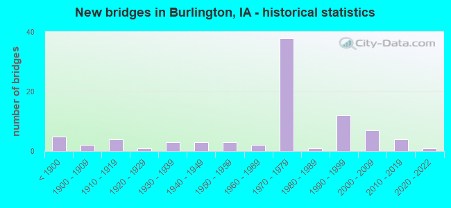
- New bridges - historical statistics
- 5Before 1900
- 21900-1909
- 41910-1919
- 11920-1929
- 31930-1939
- 31940-1949
- 31950-1959
- 21960-1969
- 381970-1979
- 11980-1989
- 121990-1999
- 72000-2009
- 42010-2019
- 12020-2022
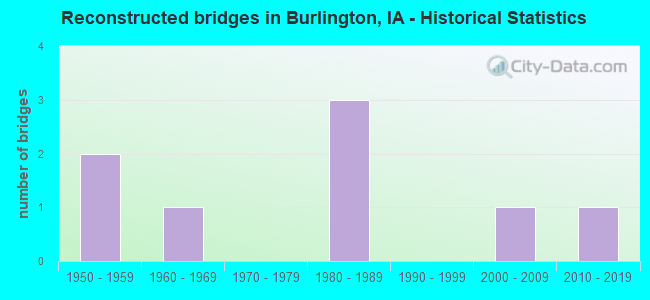
- Reconstructed bridges - Historical Statistics
- 21950-1959
- 11960-1969
- 01970-1979
- 31980-1989
- 01990-1999
- 12000-2009
- 12010-2019
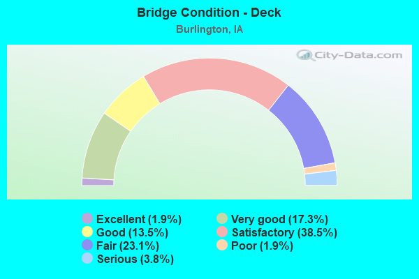
- Bridge Condition - Deck
- 1.9%Excellent
- 17.3%Very good
- 13.5%Good
- 38.5%Satisfactory
- 23.1%Fair
- 1.9%Poor
- 3.8%Serious
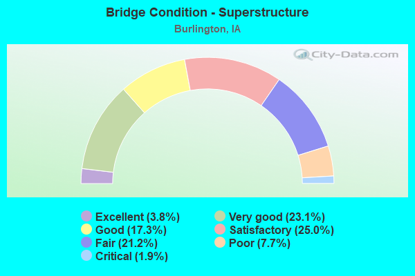
- Bridge Condition - Superstructure
- 3.8%Excellent
- 23.1%Very good
- 17.3%Good
- 25.0%Satisfactory
- 21.2%Fair
- 7.7%Poor
- 1.9%Critical
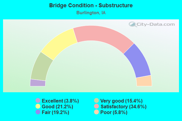
- Bridge Condition - Substructure
- 3.8%Excellent
- 15.4%Very good
- 21.2%Good
- 34.6%Satisfactory
- 19.2%Fair
- 5.8%Poor
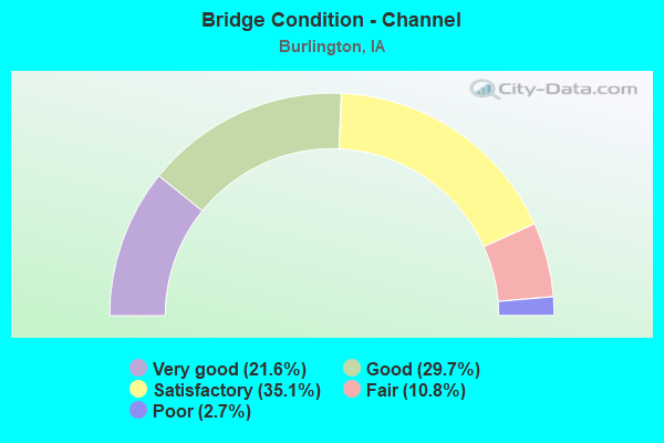
- Bridge Condition - Channel
- 21.6%Very good
- 29.7%Good
- 35.1%Satisfactory
- 10.8%Fair
- 2.7%Poor
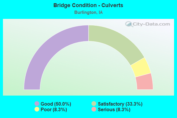
- Bridge Condition - Culverts
- 50.0%Good
- 33.3%Satisfactory
- 8.3%Poor
- 8.3%Serious
Find on map >> Show street view
Structure Number: 871, Location: 700234000 (Lat: 40.824503, Lng: -91.106942), Route carried "on" structure: City street , Year Built: 1882, Year Reconstructed: 1985, Status: Posted for load, Structure Length: 0.82m (2.69ft), Average Daily Traffic: 600 (year 1975), Average Future Daily Traffic: 600 (year 2040), Features Intersected: DES MOINES ST, Facility Carried by Structure: ASH ST
Minimum Vertical Clearance: 30+ m (98+ ft), Kilometerpoint: 0.436, Lanes on structure: 2, Lanes under structure: 2, Owner: City or Municipal Highway Agency, Approaching Roadway Width: 9.4m (30.8ft), Material/Design: Masonry, Design/Construction: Arch - Deck, Number Of Spans In Main Unit: 1, Length of Maximum Span: 7.3m (24.0ft), Curb or Sidewalk Widths: Left: 0.6m (2.0ft), Right: 0.6m (2.0ft), Curb-To-Curb Width: 9.8m (32.2ft), Out-to-Out Width: 12.8m (42.0ft)
Condition: Deck: Satisfactory, Superstructure: Fair, Substructure: Fair, Operating Rating: 52.8 metric tons, Method Used To Determine Operating Rating: Load Factor (LF), Inventory Rating: 31.7 metric tons, Method Used To Determine Inventory Rating: Load Factor (LF), Structural Evaluation: Somewhat better than minimum adequacy, Deck Geometry: Equal to present minimum criteria, Underclear: High priority of replacement, Approach Roadway Alignment: Somewhat better than minimum adequacy, Length Of Structure Improvement: 3.00m (9.84ft), Designated Inspection Frequency: Every 24 months, Inspection Date: September 2020, Bridge Improvement Cost: $160,000, Roadway Improvement Cost: $30,000, Deck Structure Type: Concrete Cast-file-Place, Wearing Surface/Protective System: Wearing Surface: Bituminous
Find on map >> Show street view
Structure Number: 881, Location: 690205000 (Lat: 40.809008, Lng: -91.106642), Route carried "on" structure: City street , Year Built: 1993, Status: Open, Structure Length: 11.46m (37.60ft), Average Daily Traffic: 2,230 (year 2014), Average Future Daily Traffic: 2,230 (year 2040), Design Load: HS 20, Features Intersected: BNSF RR & VALLEY ST, Facility Carried by Structure: 6TH ST
Minimum Vertical Clearance: 30+ m (98+ ft), Kilometerpoint: 1.957, Lanes on structure: 2, Lanes under structure: 2, Owner: City or Municipal Highway Agency, Approaching Roadway Width: 5.5m (18.0ft), Material/Design: Prestressed concrete, Design/Construction: Stringer/Multi-beam, Number Of Spans In Main Unit: 5, Length of Maximum Span: 29.3m (96.1ft), Curb or Sidewalk Widths: Left: 1.5m (4.9ft), Right: 0.0m, Curb-To-Curb Width: 13.4m (44.0ft), Out-to-Out Width: 15.8m (51.8ft)
Condition: Deck: Satisfactory, Superstructure: Good, Substructure: Very good, Operating Rating: 44.1 metric tons, Method Used To Determine Operating Rating: Assigned rating based on Load Factor Design (LFD) reported in metric tons, Inventory Rating: 32.7 metric tons, Method Used To Determine Inventory Rating: Assigned rating based on Load Factor Design (LFD) reported in metric tons, Structural Evaluation: Better than present minimum criteria, Deck Geometry: Better than present minimum criteria, Underclear: Equal to present minimum criteria, Approach Roadway Alignment: Better than present minimum criteria, Designated Inspection Frequency: Every 48 months, Inspection Date: September 2020, Deck Structure Type: Concrete Cast-file-Place, Wearing Surface/Protective System: Wearing Surface: Integral Concrete, Deck Protection: Epoxy Coated Reinforcing
Find on map >> Show street view
Structure Number: 9, Location: 000000000 (Lat: 40.781114, Lng: -91.098608), Route carried "on" structure: City street , Year Built: 1896, Year Reconstructed: 1960, Status: Closed, Structure Length: 14.14m (46.39ft), Average Daily Traffic: 780 (year 2018), Average Future Daily Traffic: 780 (year 2028), Features Intersected: CASCADE LANDING, Facility Carried by Structure: SO MAIN ST
Minimum Vertical Clearance: 30+ m (98+ ft), Kilometerpoint: 1.497, Lanes on structure: 2, Owner: City or Municipal Highway Agency, Approaching Roadway Width: 9.8m (32.2ft), Material/Design: Steel, Design/Construction: Truss - Deck, Number Of Spans In Main Unit: 4, Length of Maximum Span: 48.8m (160.1ft), Curb or Sidewalk Widths: Left: 1.2m (3.9ft), Right: 1.2m (3.9ft), Curb-To-Curb Width: 9.1m (29.9ft), Out-to-Out Width: 12.2m (40.0ft)
Condition: Deck: Good, Superstructure: Critical, Substructure: Fair, Channel: Very good, Deck Geometry: Equal to present minimum criteria, Waterway Adequacy: Equal to present desirable criteria, Approach Roadway Alignment: Equal to present desirable criteria, Bridge Posting: Required (Relationship of Operating Rating to Maximum Legal Load: 10.0 - 19.9% below), Length Of Structure Improvement: 46.50m (152.56ft), Designated Inspection Frequency: Every 24 months, Inspection Date: August 2008, Bridge Improvement Cost: $977,000, Roadway Improvement Cost: $50,000, Deck Structure Type: Open Grating
Find on map >> Show street view
Structure Number: 651, Location: 000000000 (Lat: 41.650106, Lng: -91.509508), Route carried "on" structure: City street , Year Built: 1930, Year Reconstructed: 1961, Status: Open, Structure Length: 1.07m (3.51ft), Average Daily Traffic: 151 (year 2010), Average Future Daily Traffic: 151 (year 2041), Features Intersected: RALSTON CREEK S. BRANCH, Facility Carried by Structure: SIXTH AVE
Minimum Vertical Clearance: 30+ m (98+ ft), Kilometerpoint: 0.240, Lanes on structure: 2, Owner: City or Municipal Highway Agency, Approaching Roadway Width: 7.3m (24.0ft), Skew: 4 degrees, Material/Design: Concrete continuous, Design/Construction: Culvert, Number Of Spans In Main Unit: 2, Length of Maximum Span: 5.2m (17.1ft)
Condition: Channel: Satisfactory, Culverts: Satisfactory, Operating Rating: 23.2 metric tons, Method Used To Determine Operating Rating: Field evaluation and documented engineering judgment, Inventory Rating: 17.0 metric tons, Method Used To Determine Inventory Rating: Field evaluation and documented engineering judgment, Structural Evaluation: Somewhat better than minimum adequacy, Waterway Adequacy: Equal to present minimum criteria, Approach Roadway Alignment: Better than present minimum criteria, Length Of Structure Improvement: 6.00m (19.69ft), Designated Inspection Frequency: Every 24 months, Inspection Date: June 2021, Bridge Improvement Cost: $300,000, Roadway Improvement Cost: $30,000
Find on map >> Show street view
Structure Number: 795, Location: 000000000 (Lat: 43.150014, Lng: -93.206642), Route carried "on" structure: City street , Year Built: 1965, Status: Open, Structure Length: 3.05m (10.01ft), Average Daily Traffic: 1,370 (year 1998), Average Future Daily Traffic: 1,370 (year 2042), Design Load: HS 20, Features Intersected: WILLOW CREEK, Facility Carried by Structure: 2ND ST SW
Minimum Vertical Clearance: 30+ m (98+ ft), Kilometerpoint: 0.724, Lanes on structure: 2, Owner: City or Municipal Highway Agency, Approaching Roadway Width: 12.2m (40.0ft), Skew: 2 degrees, Material/Design: Concrete continuous, Design/Construction: Slab, Number Of Spans In Main Unit: 3, Length of Maximum Span: 11.9m (39.0ft), Curb or Sidewalk Widths: Left: 1.5m (4.9ft), Right: 1.5m (4.9ft), Curb-To-Curb Width: 12.2m (40.0ft), Out-to-Out Width: 15.8m (51.8ft)
Condition: Deck: Satisfactory, Superstructure: Satisfactory, Substructure: Good, Channel: Very good, Operating Rating: 56.9 metric tons, Method Used To Determine Operating Rating: Allowable Stress (AS), Inventory Rating: 32.7 metric tons, Method Used To Determine Inventory Rating: Allowable Stress (AS), Structural Evaluation: Equal to present minimum criteria, Deck Geometry: Better than present minimum criteria, Waterway Adequacy: Equal to present desirable criteria, Approach Roadway Alignment: Equal to present desirable criteria, Designated Inspection Frequency: Every 24 months, Inspection Date: January 2022, Deck Structure Type: Concrete Cast-file-Place, Wearing Surface/Protective System: Wearing Surface: Monolithic Concrete
Find on map >> Show street view
Structure Number: 2281, Location: AT MISSOURI STATE LINE (Lat: 40.575228, Lng: -93.937153), Route carried "on" structure: Interstate 35, Year Built: 1970, Status: Open, Structure Length: 6.04m (19.82ft), Average Daily Traffic: 5,150 (year 2020), Truck Traffic: 45%, Average Future Daily Traffic: 5,150 (year 2040), Design Load: HS 20, Features Intersected: 324TH STREET
Minimum Vertical Clearance: 30+ m (98+ ft), Kilometerpoint: 0.000, Lanes on structure: 2, Lanes under structure: 2, Base Highway Network: Yes, Owner: State Highway Agency, Approaching Roadway Width: 12.2m (40.0ft), Skew: 4 degrees, Material/Design: Steel continuous, Design/Construction: Stringer/Multi-beam, Number Of Spans In Main Unit: 3, Length of Maximum Span: 22.9m (75.1ft), Curb-To-Curb Width: 12.2m (40.0ft), Out-to-Out Width: 13.2m (43.3ft)
Condition: Deck: Satisfactory, Superstructure: Fair, Substructure: Satisfactory, Operating Rating: 48.4 metric tons, Method Used To Determine Operating Rating: Load Factor (LF), Inventory Rating: 29.1 metric tons, Method Used To Determine Inventory Rating: Load Factor (LF), Structural Evaluation: Somewhat better than minimum adequacy, Deck Geometry: Better than present minimum criteria, Underclear: Equal to present minimum criteria, Approach Roadway Alignment: Equal to present desirable criteria, Designated Inspection Frequency: Every 24 months, Inspection Date: August 2020, Deck Structure Type: Concrete Cast-file-Place, Wearing Surface/Protective System: Wearing Surface: Low Slump Concrete
Find on map >> Show street view
Structure Number: 23431, Location: 000234000 (Lat: 40.818119, Lng: -91.114033), Route carried "on" structure: City street , Year Built: 2019, Status: Open, Structure Length: 15.82m (51.90ft), Average Daily Traffic: 4,600 (year 2006), Average Future Daily Traffic: 4,600 (year 2040), Design Load: HL 93, Features Intersected: BNSF RR & OSBORN, Facility Carried by Structure: MT PLEASANT ST
Minimum Vertical Clearance: 30+ m (98+ ft), Kilometerpoint: 4.163, Lanes on structure: 2, Lanes under structure: 2, Owner: City or Municipal Highway Agency, Approaching Roadway Width: 10.4m (34.1ft), Material/Design: Prestressed concrete, Design/Construction: Stringer/Multi-beam, Number Of Spans In Main Unit: 4, Length of Maximum Span: 41.8m (137.1ft), Curb or Sidewalk Widths: Left: 1.5m (4.9ft), Right: 0.0m, Curb-To-Curb Width: 10.4m (34.1ft), Out-to-Out Width: 12.9m (42.3ft)
Condition: Deck: Excellent, Superstructure: Excellent, Substructure: Excellent, Operating Rating: 42.1 metric tons, Method Used To Determine Operating Rating: Assigned ratings based on Load and Resistance Factor Design (LRFD) reported by rating factor (RF) using HL93 loadings, Inventory Rating: 32.4 metric tons, Method Used To Determine Inventory Rating: Assigned ratings based on Load and Resistance Factor Design (LRFD) reported by rating factor (RF) using HL93 loadings, Structural Evaluation: Equal to present desirable criteria, Deck Geometry: Somewhat better than minimum adequacy, Underclear: Superior to present desirable criteria, Approach Roadway Alignment: Equal to present desirable criteria, Designated Inspection Frequency: Every 24 months, Inspection Date: September 2020, Deck Structure Type: Concrete Cast-file-Place, Wearing Surface/Protective System: Wearing Surface: Monolithic Concrete, Deck Protection: Epoxy Coated Reinforcing
Find on map >> Show street view
Structure Number: 23441, Location: IN BURLINGTION (Lat: 40.812631, Lng: -91.098808), Route carried "on" structure: US 34, Year Built: 1994, Status: Open, Structure Length: 69.19m (227.00ft), Average Daily Traffic: 11,100 (year 2020), Truck Traffic: 14%, Average Future Daily Traffic: 11,100 (year 2041), Design Load: HS 20, Features Intersected: MISSISSIPPI RIVER
Minimum Vertical Clearance: 30+ m (98+ ft), Kilometerpoint: 432.894, Lanes on structure: 5, Base Highway Network: Yes, Owner: State Highway Agency, Approaching Roadway Width: 31.1m (102.0ft), Skew: 30 degrees, Navigation Control: Yes ( Vertical Clearance: 18.3m (60.0ft), Horizontal Clearance: 196.3m (644.0ft)), Material/Design: Steel continuous, Design/Construction: Stayed Girder, Number Of Spans In Main Unit: 3, Number Of Approach Spans: 7, Length of Maximum Span: 201.2m (660.1ft), Curb-To-Curb Width: 23.8m (78.1ft), Out-to-Out Width: 26.7m (87.6ft)
Condition: Deck: Satisfactory, Superstructure: Good, Substructure: Satisfactory, Channel: Good, Operating Rating: 55.3 metric tons, Method Used To Determine Operating Rating: Load Factor (LF), Inventory Rating: 33.6 metric tons, Method Used To Determine Inventory Rating: Load Factor (LF), Structural Evaluation: Equal to present minimum criteria, Deck Geometry: Better than present minimum criteria, Waterway Adequacy: Superior to present desirable criteria, Approach Roadway Alignment: Equal to present desirable criteria, Designated Inspection Frequency: Every 24 months, Critical Feature Inspection Frequency: Every 24 months, Underwater Inspection Frequency: Every 60 months, Inspection Date: October 2021, Critical Feature Inspection Date: October 2021, Underwater Inspection Date: July 2020, Deck Structure Type: Concrete Precast Panels, Wearing Surface/Protective System: Wearing Surface: Low Slump Concrete, Deck Protection: Epoxy Coated Reinforcing
Find on map >> Show street view
Structure Number: 2346, Location: 069033505 (Lat: 40.733661, Lng: -91.170647), Route carried "on" structure: County highway , Year Built: 1927, Year Reconstructed: 1957, Status: Open, Structure Length: 2.44m (8.01ft), Average Daily Traffic: 380 (year 2014), Average Future Daily Traffic: 380 (year 2041), Design Load: H 15, Features Intersected: BRUSH CREEK, Facility Carried by Structure: LOCAL ROAD
Minimum Vertical Clearance: 30+ m (98+ ft), Kilometerpoint: 0.958, Lanes on structure: 2, Owner: County Highway Agency, Approaching Roadway Width: 11.0m (36.1ft), Skew: 4 degrees, Material/Design: Steel continuous, Design/Construction: Girder and Floorbeam System, Number Of Spans In Main Unit: 2, Length of Maximum Span: 12.2m (40.0ft), Curb or Sidewalk Widths: Left: 0.3m (1.0ft), Right: 0.3m (1.0ft), Curb-To-Curb Width: 9.1m (29.9ft), Out-to-Out Width: 10.3m (33.8ft)
Condition: Deck: Serious, Superstructure: Fair, Substructure: Poor, Channel: Satisfactory, Operating Rating: 36.7 metric tons, Method Used To Determine Operating Rating: Allowable Stress (AS), Inventory Rating: 23.3 metric tons, Method Used To Determine Inventory Rating: Allowable Stress (AS), Structural Evaluation: Meets minimum limits, Deck Geometry: Equal to present minimum criteria, Waterway Adequacy: Better than present minimum criteria, Approach Roadway Alignment: Better than present minimum criteria, Length Of Structure Improvement: 11.20m (36.75ft), Designated Inspection Frequency: Every 24 months, Critical Feature Inspection Frequency: Every 24 months, Inspection Date: September 2021, Critical Feature Inspection Date: July 2020, Bridge Improvement Cost: $370,000, Roadway Improvement Cost: $37,000, Deck Structure Type: Concrete Cast-file-Place, Wearing Surface/Protective System: Wearing Surface: Bituminous
Find on map >> Show street view
Structure Number: 2347, Location: 3.9 mi. N of jct. IA 16 (Lat: 40.745733, Lng: -91.156844), Route carried "on" structure: US 61, Year Built: 1956, Year Reconstructed: 2015, Status: Open, Structure Length: 4.62m (15.16ft), Average Daily Traffic: 4,800 (year 2020), Truck Traffic: 13%, Average Future Daily Traffic: 4,800 (year 2040), Design Load: HL 93, Features Intersected: SPRING CREEK
Minimum Vertical Clearance: 30+ m (98+ ft), Kilometerpoint: 252.252, Lanes on structure: 2, Owner: State Highway Agency, Approaching Roadway Width: 12.2m (40.0ft), Material/Design: Steel continuous, Design/Construction: Stringer/Multi-beam, Number Of Spans In Main Unit: 3, Length of Maximum Span: 17.8m (58.4ft), Curb-To-Curb Width: 12.2m (40.0ft), Out-to-Out Width: 13.2m (43.3ft)
Condition: Deck: Good, Superstructure: Very good, Substructure: Good, Channel: Good, Operating Rating: 42.1 metric tons, Method Used To Determine Operating Rating: Assigned ratings based on Load and Resistance Factor Design (LRFD) reported by rating factor (RF) using HL93 loadings, Inventory Rating: 32.4 metric tons, Method Used To Determine Inventory Rating: Assigned ratings based on Load and Resistance Factor Design (LRFD) reported by rating factor (RF) using HL93 loadings, Structural Evaluation: Better than present minimum criteria, Deck Geometry: Better than present minimum criteria, Waterway Adequacy: Equal to present minimum criteria, Approach Roadway Alignment: Equal to present desirable criteria, Designated Inspection Frequency: Every 24 months, Inspection Date: April 2020, Deck Structure Type: Concrete Cast-file-Place, Wearing Surface/Protective System: Wearing Surface: Monolithic Concrete, Deck Protection: Epoxy Coated Reinforcing
Find on map >> Show street view
Structure Number: 23481, Location: 0.8 mi. N of Jct. U.S. 34 (Lat: 40.828839, Lng: -91.141294), Route carried "on" structure: US 61, Year Built: 1977, Status: Open, Structure Length: 5.88m (19.29ft), Average Daily Traffic: 5,200 (year 2020), Truck Traffic: 6%, Average Future Daily Traffic: 5,200 (year 2040), Design Load: HS 20, Features Intersected: BNSF RR
Minimum Vertical Clearance: 30+ m (98+ ft), Kilometerpoint: 66.266, Lanes on structure: 2, Base Highway Network: Yes, Owner: State Highway Agency, Approaching Roadway Width: 7.2m (23.6ft), Skew: 2 degrees, Material/Design: Prestressed concrete, Design/Construction: Stringer/Multi-beam, Number Of Spans In Main Unit: 3, Length of Maximum Span: 21.0m (68.9ft), Curb or Sidewalk Widths: Left: 2.4m (7.9ft), Right: 0.0m, Curb-To-Curb Width: 8.6m (28.2ft), Out-to-Out Width: 11.5m (37.7ft)
Condition: Deck: Very good, Superstructure: Very good, Substructure: Very good, Operating Rating: 88.3 metric tons, Method Used To Determine Operating Rating: Load Factor (LF), Inventory Rating: 52.9 metric tons, Method Used To Determine Inventory Rating: Load Factor (LF), Structural Evaluation: Equal to present desirable criteria, Deck Geometry: High priority of corrective action, Underclear: Superior to present desirable criteria, Approach Roadway Alignment: Somewhat better than minimum adequacy, Designated Inspection Frequency: Every 24 months, Inspection Date: April 2020, Deck Structure Type: Concrete Cast-file-Place, Wearing Surface/Protective System: Wearing Surface: Monolithic Concrete, Deck Protection: Epoxy Coated Reinforcing
Find on map >> Show street view
Structure Number: 23483, Location: 0.8 mi. N of Jct. U.S. 34 (Lat: 40.829336, Lng: -91.141450), Route carried "on" structure: US 61, Year Built: 1977, Year Reconstructed: 2012, Status: Open, Structure Length: 5.88m (19.29ft), Average Daily Traffic: 5,200 (year 2020), Truck Traffic: 6%, Average Future Daily Traffic: 5,200 (year 2040), Design Load: HS 20, Features Intersected: BNSF RR
Minimum Vertical Clearance: 30+ m (98+ ft), Kilometerpoint: 242.770, Lanes on structure: 2, Owner: State Highway Agency, Approaching Roadway Width: 7.2m (23.6ft), Skew: 2 degrees, Material/Design: Prestressed concrete, Design/Construction: Stringer/Multi-beam, Number Of Spans In Main Unit: 3, Length of Maximum Span: 21.0m (68.9ft), Curb or Sidewalk Widths: Left: 1.8m (5.9ft), Right: 2.4m (7.9ft), Curb-To-Curb Width: 8.5m (27.9ft), Out-to-Out Width: 11.5m (37.7ft)
Condition: Deck: Good, Superstructure: Very good, Substructure: Very good, Operating Rating: 73.7 metric tons, Method Used To Determine Operating Rating: Load Factor (LF), Inventory Rating: 30.7 metric tons, Method Used To Determine Inventory Rating: Load Factor (LF), Structural Evaluation: Better than present minimum criteria, Deck Geometry: High priority of corrective action, Underclear: Better than present minimum criteria, Approach Roadway Alignment: Somewhat better than minimum adequacy, Designated Inspection Frequency: Every 24 months, Inspection Date: April 2020, Deck Structure Type: Concrete Cast-file-Place, Wearing Surface/Protective System: Wearing Surface: Monolithic Concrete, Deck Protection: Epoxy Coated Reinforcing
Find on map >> Show street view
Structure Number: 23521, Location: 070022908 (Lat: 40.836136, Lng: -91.109478), Route carried "on" structure: City street , Year Built: 2021, Status: Open, Structure Length: 10.12m (33.20ft), Average Daily Traffic: 3,970 (year 2018), Average Future Daily Traffic: 3,970 (year 2041), Design Load: HL 93, Features Intersected: FLINT CREEK, Facility Carried by Structure: X99 DES MOINES AVE
Minimum Vertical Clearance: 30+ m (98+ ft), Kilometerpoint: 1.276, Lanes on structure: 2, Owner: County Highway Agency, Approaching Roadway Width: 12.2m (40.0ft), Skew: 3 degrees, Material/Design: Prestressed concrete, Design/Construction: Stringer/Multi-beam, Number Of Spans In Main Unit: 3, Length of Maximum Span: 46.3m (151.9ft), Curb-To-Curb Width: 12.2m (40.0ft), Out-to-Out Width: 13.0m (42.7ft)
Condition: Deck: Very good, Superstructure: Excellent, Substructure: Excellent, Channel: Very good, Operating Rating: 42.1 metric tons, Method Used To Determine Operating Rating: Assigned ratings based on Load and Resistance Factor Design (LRFD) reported by rating factor (RF) using HL93 loadings, Inventory Rating: 32.4 metric tons, Method Used To Determine Inventory Rating: Assigned ratings based on Load and Resistance Factor Design (LRFD) reported by rating factor (RF) using HL93 loadings, Structural Evaluation: Equal to present desirable criteria, Deck Geometry: Equal to present minimum criteria, Waterway Adequacy: Equal to present desirable criteria, Approach Roadway Alignment: Equal to present desirable criteria, Designated Inspection Frequency: Every 24 months, Inspection Date: September 2021, Deck Structure Type: Concrete Cast-file-Place, Wearing Surface/Protective System: Wearing Surface: Monolithic Concrete, Deck Protection: Epoxy Coated Reinforcing
Find on map >> Show street view
Structure Number: 2353, Location: 070021712 (Lat: 40.858267, Lng: -91.106447), Route carried "on" structure: County highway , Year Built: 1938, Status: Open, Structure Length: 5.64m (18.50ft), Average Daily Traffic: 1,910 (year 2018), Average Future Daily Traffic: 1,910 (year 2041), Design Load: H 15, Features Intersected: DRY BRANCH CREEK, Facility Carried by Structure: X 99
Minimum Vertical Clearance: 30+ m (98+ ft), Kilometerpoint: 2.272, Lanes on structure: 2, Base Highway Network: Yes, Owner: County Highway Agency, Approaching Roadway Width: 6.7m (22.0ft), Material/Design: Steel continuous, Design/Construction: Stringer/Multi-beam, Number Of Spans In Main Unit: 3, Length of Maximum Span: 21.3m (69.9ft), Curb-To-Curb Width: 7.2m (23.6ft), Out-to-Out Width: 8.5m (27.9ft)
Condition: Deck: Serious, Superstructure: Poor, Substructure: Poor, Channel: Satisfactory, Operating Rating: 39.9 metric tons, Method Used To Determine Operating Rating: Allowable Stress (AS), Inventory Rating: 22.9 metric tons, Method Used To Determine Inventory Rating: Allowable Stress (AS), Structural Evaluation: Meets minimum limits, Deck Geometry: High priority of corrective action, Waterway Adequacy: Better than present minimum criteria, Approach Roadway Alignment: Equal to present minimum criteria, Length Of Structure Improvement: 22.60m (74.15ft), Designated Inspection Frequency: Every 12 months, Inspection Date: September 2021, Bridge Improvement Cost: $746,000, Roadway Improvement Cost: $75,000, Deck Structure Type: Concrete Cast-file-Place, Wearing Surface/Protective System: Wearing Surface: Low Slump Concrete
Find on map >> Show street view
Structure Number: 2362, Location: 1.7 mi E of Jct US 61 (Lat: 40.815536, Lng: -91.110200), Route carried "on" structure: City street , Year Built: 1970, Status: Open, Structure Length: 4.39m (14.40ft), Average Daily Traffic: 6,400 (year 2018), Average Future Daily Traffic: 6,400 (year 2041), Design Load: HS 20, Features Intersected: US 34, Facility Carried by Structure: CENTRAL AVE
Minimum Vertical Clearance: 30+ m (98+ ft), Kilometerpoint: 3.788, Lanes on structure: 2, Lanes under structure: 4, Owner: State Highway Agency, Approaching Roadway Width: 10.1m (33.1ft), Material/Design: Prestressed concrete, Design/Construction: Stringer/Multi-beam, Number Of Spans In Main Unit: 2, Length of Maximum Span: 21.9m (71.9ft), Curb or Sidewalk Widths: Left: 0.0m, Right: 1.5m (4.9ft), Curb-To-Curb Width: 16.5m (54.1ft), Out-to-Out Width: 19.1m (62.7ft)
Condition: Deck: Fair, Superstructure: Fair, Substructure: Fair, Operating Rating: 81.4 metric tons, Method Used To Determine Operating Rating: Load Factor (LF), Inventory Rating: 35.4 metric tons, Method Used To Determine Inventory Rating: Load Factor (LF), Structural Evaluation: Somewhat better than minimum adequacy, Deck Geometry: Superior to present desirable criteria, Underclear: Equal to present minimum criteria, Approach Roadway Alignment: Meets minimum limits, Designated Inspection Frequency: Every 24 months, Inspection Date: November 2021, Deck Structure Type: Concrete Cast-file-Place, Wearing Surface/Protective System: Wearing Surface: Monolithic Concrete
Find on map >> Show street view
Structure Number: 2363, Location: 1.8 mi. E of Jct. US 61 (Lat: 40.814944, Lng: -91.107144), Route carried "on" structure: City street , Year Built: 1971, Status: Open, Structure Length: 6.74m (22.11ft), Average Daily Traffic: 1,960 (year 1982), Average Future Daily Traffic: 1,960 (year 2041), Design Load: HS 20, Features Intersected: US 34, Facility Carried by Structure: 8TH ST
Minimum Vertical Clearance: 30+ m (98+ ft), Kilometerpoint: 2.435, Lanes on structure: 2, Lanes under structure: 6, Owner: State Highway Agency, Approaching Roadway Width: 9.4m (30.8ft), Material/Design: Prestressed concrete, Design/Construction: Stringer/Multi-beam, Number Of Spans In Main Unit: 3, Length of Maximum Span: 29.3m (96.1ft), Curb or Sidewalk Widths: Left: 1.5m (4.9ft), Right: 1.5m (4.9ft), Curb-To-Curb Width: 9.1m (29.9ft), Out-to-Out Width: 15.5m (50.9ft)
Condition: Deck: Fair, Superstructure: Good, Substructure: Satisfactory, Operating Rating: 82.9 metric tons, Method Used To Determine Operating Rating: Load Factor (LF), Inventory Rating: 33.4 metric tons, Method Used To Determine Inventory Rating: Load Factor (LF), Structural Evaluation: Equal to present minimum criteria, Deck Geometry: Somewhat better than minimum adequacy, Underclear: Equal to present minimum criteria, Approach Roadway Alignment: Somewhat better than minimum adequacy, Designated Inspection Frequency: Every 24 months, Inspection Date: November 2021, Deck Structure Type: Concrete Cast-file-Place, Wearing Surface/Protective System: Wearing Surface: Monolithic Concrete
Find on map >> Show street view
Structure Number: 2365, Location: 2.0 mi. E of Jct. US 61 (Lat: 40.814817, Lng: -91.103497), Route carried "on" structure: City street , Year Built: 1970, Status: Open, Structure Length: 7.07m (23.20ft), Average Daily Traffic: 930 (year 2010), Average Future Daily Traffic: 930 (year 2041), Design Load: HS 20, Features Intersected: US 34, Facility Carried by Structure: 5TH ST
Minimum Vertical Clearance: 30+ m (98+ ft), Kilometerpoint: 2.176, Lanes on structure: 2, Lanes under structure: 5, Owner: State Highway Agency, Approaching Roadway Width: 9.4m (30.8ft), Material/Design: Prestressed concrete, Design/Construction: Stringer/Multi-beam, Number Of Spans In Main Unit: 4, Length of Maximum Span: 18.6m (61.0ft), Curb or Sidewalk Widths: Left: 1.5m (4.9ft), Right: 1.5m (4.9ft), Curb-To-Curb Width: 12.8m (42.0ft), Out-to-Out Width: 17.1m (56.1ft)
Condition: Deck: Satisfactory, Superstructure: Very good, Substructure: Satisfactory, Operating Rating: 65.8 metric tons, Method Used To Determine Operating Rating: Load Factor (LF), Inventory Rating: 31.1 metric tons, Method Used To Determine Inventory Rating: Load Factor (LF), Structural Evaluation: Equal to present minimum criteria, Deck Geometry: Equal to present desirable criteria, Underclear: Better than present minimum criteria, Approach Roadway Alignment: Meets minimum limits, Designated Inspection Frequency: Every 24 months, Inspection Date: November 2021, Deck Structure Type: Concrete Cast-file-Place, Wearing Surface/Protective System: Wearing Surface: Low Slump Concrete
Find on map >> Show street view
Structure Number: 3208, Location: 3.4 MI. W OF Jct. IA 1 (Lat: 41.685889, Lng: -91.564689), Route carried "on" structure: City street , Year Built: 1962, Status: Open, Structure Length: 7.04m (23.10ft), Average Daily Traffic: 10,500 (year 2018), Average Future Daily Traffic: 10,500 (year 2040), Design Load: H 20, Features Intersected: I-80, Facility Carried by Structure: 1ST AVE SB
Minimum Vertical Clearance: 30+ m (98+ ft), Kilometerpoint: 2.773, Lanes on structure: 2, Lanes under structure: 6, Owner: State Highway Agency, Approaching Roadway Width: 8.5m (27.9ft), Skew: 20 degrees, Material/Design: Prestressed concrete, Design/Construction: Stringer/Multi-beam, Number Of Spans In Main Unit: 4, Length of Maximum Span: 19.8m (65.0ft), Curb-To-Curb Width: 8.5m (27.9ft), Out-to-Out Width: 9.9m (32.5ft)
Condition: Deck: Good, Superstructure: Good, Substructure: Satisfactory, Operating Rating: 65.8 metric tons, Method Used To Determine Operating Rating: Load Factor (LF), Inventory Rating: 32.4 metric tons, Method Used To Determine Inventory Rating: Load Factor (LF), Structural Evaluation: Equal to present minimum criteria, Deck Geometry: High priority of corrective action, Underclear: Equal to present minimum criteria, Approach Roadway Alignment: Better than present minimum criteria, Designated Inspection Frequency: Every 24 months, Inspection Date: August 2020, Deck Structure Type: Concrete Cast-file-Place, Wearing Surface/Protective System: Wearing Surface: Low Slump Concrete
Find on map >> Show street view
Structure Number: 142911, Location: 069032307 (Lat: 40.756708, Lng: -91.169497), Route carried "on" structure: County highway , Year Built: 1995, Status: Open, Structure Length: 0.79m (2.59ft), Average Daily Traffic: 50 (year 2014), Average Future Daily Traffic: 50 (year 2039), Design Load: HS 20, Features Intersected: SPRING CREEK, Facility Carried by Structure: LOCAL
Minimum Vertical Clearance: 30+ m (98+ ft), Kilometerpoint: 3.458, Lanes on structure: 2, Owner: County Highway Agency, Approaching Roadway Width: 8.2m (26.9ft), Skew: 1 degrees, Material/Design: Concrete continuous, Design/Construction: Culvert, Number Of Spans In Main Unit: 2, Length of Maximum Span: 3.7m (12.1ft)
Condition: Channel: Good, Culverts: Good, Operating Rating: 44.1 metric tons, Method Used To Determine Operating Rating: Assigned rating based on Load Factor Design (LFD) reported in metric tons, Inventory Rating: 32.7 metric tons, Method Used To Determine Inventory Rating: Assigned rating based on Load Factor Design (LFD) reported in metric tons, Structural Evaluation: Better than present minimum criteria, Waterway Adequacy: Equal to present desirable criteria, Approach Roadway Alignment: Equal to present desirable criteria, Length Of Structure Improvement: 2.50m (8.20ft), Designated Inspection Frequency: Every 48 months, Inspection Date: September 2019, Bridge Improvement Cost: $15,000, Roadway Improvement Cost: $2,000
Find on map >> Show street view
Structure Number: 142921, Location: 069032509 (Lat: 40.742686, Lng: -91.144897), Route carried "on" structure: County highway , Year Built: 1988, Status: Open, Structure Length: 1.34m (4.40ft), Average Daily Traffic: 1,700 (year 2018), Truck Traffic: 13%, Average Future Daily Traffic: 1,700 (year 2039), Design Load: HS 20, Features Intersected: SPRING CREEK, Facility Carried by Structure: SUMMER ST
Minimum Vertical Clearance: 30+ m (98+ ft), Kilometerpoint: 1.519, Lanes on structure: 2, Owner: County Highway Agency, Approaching Roadway Width: 11.3m (37.1ft), Skew: 3 degrees, Material/Design: Concrete continuous, Design/Construction: Culvert, Number Of Spans In Main Unit: 3, Length of Maximum Span: 4.3m (14.1ft)
Condition: Channel: Satisfactory, Culverts: Satisfactory, Operating Rating: 44.1 metric tons, Method Used To Determine Operating Rating: Assigned rating based on Load Factor Design (LFD) reported in metric tons, Inventory Rating: 32.7 metric tons, Method Used To Determine Inventory Rating: Assigned rating based on Load Factor Design (LFD) reported in metric tons, Structural Evaluation: Equal to present minimum criteria, Waterway Adequacy: Equal to present desirable criteria, Approach Roadway Alignment: Equal to present desirable criteria, Length Of Structure Improvement: 3.80m (12.47ft), Designated Inspection Frequency: Every 48 months, Inspection Date: September 2019, Bridge Improvement Cost: $15,000, Roadway Improvement Cost: $2,000
Find on map >> Show street view
Structure Number: 142931, Location: 069032604 (Lat: 40.745931, Lng: -91.177311), Route carried "on" structure: County highway , Year Built: 2006, Status: Open, Structure Length: 3.05m (10.01ft), Average Daily Traffic: 50 (year 2014), Average Future Daily Traffic: 50 (year 2038), Design Load: HS 20, Features Intersected: BRUSH CREEK, Facility Carried by Structure: FM
Minimum Vertical Clearance: 30+ m (98+ ft), Kilometerpoint: 2.005, Lanes on structure: 2, Owner: County Highway Agency, Approaching Roadway Width: 10.4m (34.1ft), Material/Design: Prestressed concrete, Design/Construction: Stringer/Multi-beam, Number Of Spans In Main Unit: 1, Length of Maximum Span: 29.6m (97.1ft), Curb-To-Curb Width: 9.3m (30.5ft), Out-to-Out Width: 10.1m (33.1ft)
Condition: Deck: Very good, Superstructure: Very good, Substructure: Very good, Channel: Very good, Operating Rating: 89.2 metric tons, Method Used To Determine Operating Rating: Load Factor (LF), Inventory Rating: 40.8 metric tons, Method Used To Determine Inventory Rating: Load Factor (LF), Structural Evaluation: Equal to present desirable criteria, Deck Geometry: Better than present minimum criteria, Waterway Adequacy: Equal to present desirable criteria, Approach Roadway Alignment: Better than present minimum criteria, Length Of Structure Improvement: 8.80m (28.87ft), Designated Inspection Frequency: Every 48 months, Inspection Date: September 2018, Bridge Improvement Cost: $15,000, Roadway Improvement Cost: $2,000, Deck Structure Type: Concrete Cast-file-Place, Wearing Surface/Protective System: Wearing Surface: Monolithic Concrete
Find on map >> Show street view
Structure Number: 143031, Location: 070021706 (Lat: 40.862681, Lng: -91.109653), Route carried "on" structure: County highway , Year Built: 1998, Status: Open, Structure Length: 1.77m (5.81ft), Average Daily Traffic: 110 (year 2018), Average Future Daily Traffic: 110 (year 2039), Design Load: HS 20, Features Intersected: TURKEY HOLLOW CREEK, Facility Carried by Structure: FM WALKER RD
Minimum Vertical Clearance: 30+ m (98+ ft), Kilometerpoint: 0.616, Lanes on structure: 2, Owner: County Highway Agency, Approaching Roadway Width: 9.1m (29.9ft), Skew: 3 degrees, Material/Design: Prestressed concrete, Design/Construction: Box Beam or Girders - Multiple, Number Of Spans In Main Unit: 1, Length of Maximum Span: 16.8m (55.1ft), Curb-To-Curb Width: 9.6m (31.5ft), Out-to-Out Width: 9.8m (32.2ft)
Condition: Deck: Very good, Superstructure: Very good, Substructure: Good, Channel: Very good, Operating Rating: 44.1 metric tons, Method Used To Determine Operating Rating: Allowable Stress (AS), Inventory Rating: 32.7 metric tons, Method Used To Determine Inventory Rating: Allowable Stress (AS), Structural Evaluation: Better than present minimum criteria, Deck Geometry: Equal to present minimum criteria, Waterway Adequacy: Better than present minimum criteria, Approach Roadway Alignment: Equal to present desirable criteria, Length Of Structure Improvement: 5.80m (19.03ft), Designated Inspection Frequency: Every 48 months, Inspection Date: September 2019, Bridge Improvement Cost: $15,000, Roadway Improvement Cost: $2,000, Deck Structure Type: Concrete Cast-file-Place, Wearing Surface/Protective System: Wearing Surface: Monolithic Concrete
Find on map >> Show street view
Structure Number: 143041, Location: 070021704 (Lat: 40.860794, Lng: -91.109586), Route carried "on" structure: County highway , Year Built: 1998, Status: Open, Structure Length: 1.98m (6.50ft), Average Daily Traffic: 100 (year 2014), Average Future Daily Traffic: 100 (year 2039), Design Load: HS 20, Features Intersected: TURKEY HOLLOW CREEK, Facility Carried by Structure: LOC Y CAMP RD
Minimum Vertical Clearance: 30+ m (98+ ft), Kilometerpoint: 0.027, Lanes on structure: 2, Owner: County Highway Agency, Approaching Roadway Width: 9.1m (29.9ft), Material/Design: Prestressed concrete, Design/Construction: Box Beam or Girders - Multiple, Number Of Spans In Main Unit: 1, Length of Maximum Span: 18.9m (62.0ft), Curb-To-Curb Width: 9.6m (31.5ft), Out-to-Out Width: 9.8m (32.2ft)
Condition: Deck: Very good, Superstructure: Very good, Substructure: Good, Channel: Very good, Operating Rating: 44.1 metric tons, Method Used To Determine Operating Rating: Allowable Stress (AS), Inventory Rating: 32.7 metric tons, Method Used To Determine Inventory Rating: Allowable Stress (AS), Structural Evaluation: Better than present minimum criteria, Deck Geometry: Better than present minimum criteria, Waterway Adequacy: Equal to present desirable criteria, Approach Roadway Alignment: Somewhat better than minimum adequacy, Length Of Structure Improvement: 6.50m (21.33ft), Designated Inspection Frequency: Every 48 months, Inspection Date: September 2019, Bridge Improvement Cost: $15,000, Roadway Improvement Cost: $2,000, Deck Structure Type: Concrete Cast-file-Place, Wearing Surface/Protective System: Wearing Surface: Monolithic Concrete
Find on map >> Show street view
Structure Number: 143051, Location: 070021910 (Lat: 40.843353, Lng: -91.135333), Route carried "on" structure: County highway , Year Built: 2000, Status: Open, Structure Length: 8.87m (29.10ft), Average Daily Traffic: 670 (year 2018), Truck Traffic: 36%, Average Future Daily Traffic: 670 (year 2041), Design Load: HS 20, Features Intersected: FLINT RIVER, Facility Carried by Structure: FM
Minimum Vertical Clearance: 30+ m (98+ ft), Kilometerpoint: 0.219, Lanes on structure: 2, Owner: County Highway Agency, Approaching Roadway Width: 7.9m (25.9ft), Skew: 3 degrees, Material/Design: Prestressed concrete, Design/Construction: Stringer/Multi-beam, Number Of Spans In Main Unit: 3, Length of Maximum Span: 32.6m (107.0ft), Curb-To-Curb Width: 9.1m (29.9ft), Out-to-Out Width: 10.1m (33.1ft)
Condition: Deck: Very good, Superstructure: Very good, Substructure: Very good, Channel: Very good, Operating Rating: 61.4 metric tons, Method Used To Determine Operating Rating: Load Factor (LF), Inventory Rating: 33.9 metric tons, Method Used To Determine Inventory Rating: Load Factor (LF), Structural Evaluation: Equal to present desirable criteria, Deck Geometry: Equal to present minimum criteria, Waterway Adequacy: Equal to present desirable criteria, Approach Roadway Alignment: Equal to present desirable criteria, Length Of Structure Improvement: 29.10m (95.47ft), Designated Inspection Frequency: Every 24 months, Inspection Date: September 2021, Bridge Improvement Cost: $15,000, Roadway Improvement Cost: $2,000, Deck Structure Type: Concrete Cast-file-Place, Wearing Surface/Protective System: Wearing Surface: Monolithic Concrete
Find on map >> Show street view
Structure Number: 143061, Location: 070022103 (Lat: 40.849497, Lng: -91.099514), Route carried "on" structure: County highway , Year Built: 1970, Status: Open, Structure Length: 3.47m (11.38ft), Average Daily Traffic: 530 (year 2018), Truck Traffic: 6%, Average Future Daily Traffic: 530 (year 2041), Design Load: H 20, Features Intersected: DRY BRANCH, Facility Carried by Structure: FM
Minimum Vertical Clearance: 30+ m (98+ ft), Kilometerpoint: 1.659, Lanes on structure: 2, Owner: County Highway Agency, Approaching Roadway Width: 9.1m (29.9ft), Skew: 3 degrees, Material/Design: Concrete continuous, Design/Construction: Slab, Number Of Spans In Main Unit: 3, Length of Maximum Span: 13.4m (44.0ft), Curb-To-Curb Width: 9.1m (29.9ft), Out-to-Out Width: 9.8m (32.2ft)
Condition: Deck: Poor, Superstructure: Poor, Substructure: Satisfactory, Channel: Good, Operating Rating: 49.0 metric tons, Method Used To Determine Operating Rating: Allowable Stress (AS), Inventory Rating: 28.6 metric tons, Method Used To Determine Inventory Rating: Allowable Stress (AS), Structural Evaluation: Meets minimum limits, Deck Geometry: Equal to present minimum criteria, Waterway Adequacy: Better than present minimum criteria, Approach Roadway Alignment: Equal to present minimum criteria, Length Of Structure Improvement: 11.40m (37.40ft), Designated Inspection Frequency: Every 24 months, Inspection Date: September 2021, Bridge Improvement Cost: $15,000, Roadway Improvement Cost: $2,000, Deck Structure Type: Concrete Cast-file-Place, Wearing Surface/Protective System: Wearing Surface: Monolithic Concrete
Find on map >> Show street view
Structure Number: 143071, Location: 070022105 (Lat: 40.851739, Lng: -91.090678), Route carried "on" structure: County highway , Year Built: 1972, Status: Open, Structure Length: 1.07m (3.51ft), Average Daily Traffic: 530 (year 2018), Truck Traffic: 6%, Average Future Daily Traffic: 530 (year 2041), Design Load: H 20, Features Intersected: BACKWATER (PUMP STATION), Facility Carried by Structure: FM
Minimum Vertical Clearance: 30+ m (98+ ft), Kilometerpoint: 2.499, Lanes on structure: 2, Owner: County Highway Agency, Approaching Roadway Width: 9.1m (29.9ft), Skew: 3 degrees, Material/Design: Prestressed concrete, Design/Construction: Tee Beam, Number Of Spans In Main Unit: 1, Length of Maximum Span: 10.1m (33.1ft), Curb-To-Curb Width: 9.1m (29.9ft), Out-to-Out Width: 9.8m (32.2ft)
Condition: Deck: Fair, Superstructure: Satisfactory, Substructure: Poor, Channel: Good, Operating Rating: 60.5 metric tons, Method Used To Determine Operating Rating: Allowable Stress (AS), Inventory Rating: 33.0 metric tons, Method Used To Determine Inventory Rating: Allowable Stress (AS), Structural Evaluation: Meets minimum limits, Deck Geometry: Equal to present minimum criteria, Waterway Adequacy: Better than present minimum criteria, Approach Roadway Alignment: Equal to present minimum criteria, Length Of Structure Improvement: 3.50m (11.48ft), Designated Inspection Frequency: Every 24 months, Inspection Date: September 2021, Bridge Improvement Cost: $15,000, Roadway Improvement Cost: $2,000, Deck Structure Type: Concrete Cast-file-Place, Wearing Surface/Protective System: Wearing Surface: Monolithic Concrete
Find on map >> Show street view
Structure Number: 14312, Location: 070031205 (Lat: 40.870286, Lng: -91.151314), Route carried "on" structure: County highway , Year Built: 1900, Status: Open, Structure Length: 1.28m (4.20ft), Average Daily Traffic: 25 (year 2014), Average Future Daily Traffic: 25 (year 2040), Design Load: HS 20, Features Intersected: KNOTTY CREEK, Facility Carried by Structure: LOCAL
Minimum Vertical Clearance: 30+ m (98+ ft), Kilometerpoint: 7.516, Lanes on structure: 2, Owner: County Highway Agency, Approaching Roadway Width: 5.5m (18.0ft), Material/Design: Steel, Design/Construction: Slab, Number Of Spans In Main Unit: 1, Length of Maximum Span: 12.5m (41.0ft), Curb-To-Curb Width: 6.4m (21.0ft), Out-to-Out Width: 6.4m (21.0ft)
Condition: Deck: Very good, Superstructure: Very good, Substructure: Fair, Channel: Satisfactory, Operating Rating: 52.3 metric tons, Method Used To Determine Operating Rating: Load Factor (LF), Inventory Rating: 31.4 metric tons, Method Used To Determine Inventory Rating: Load Factor (LF), Structural Evaluation: Somewhat better than minimum adequacy, Deck Geometry: Somewhat better than minimum adequacy, Waterway Adequacy: Somewhat better than minimum adequacy, Approach Roadway Alignment: Meets minimum limits, Length Of Structure Improvement: 5.00m (16.40ft), Designated Inspection Frequency: Every 24 months, Inspection Date: September 2020, Bridge Improvement Cost: $15,000, Roadway Improvement Cost: $2,000, Deck Structure Type: Concrete Cast-file-Place, Wearing Surface/Protective System: Wearing Surface: Monolithic Concrete
Find on map >> Show street view
Structure Number: 143791, Location: 071033603 (Lat: 40.901625, Lng: -91.148069), Route carried "on" structure: County highway , Year Built: 2006, Status: Open, Structure Length: 1.10m (3.61ft), Average Daily Traffic: 100 (year 2014), Average Future Daily Traffic: 100 (year 2039), Design Load: HS 20, Features Intersected: KNOTTY CREEK, Facility Carried by Structure: LOCAL
Minimum Vertical Clearance: 30+ m (98+ ft), Kilometerpoint: 4.620, Lanes on structure: 2, Owner: County Highway Agency, Approaching Roadway Width: 7.9m (25.9ft), Material/Design: Steel, Design/Construction: Slab, Number Of Spans In Main Unit: 1, Length of Maximum Span: 10.1m (33.1ft), Curb-To-Curb Width: 7.6m (24.9ft), Out-to-Out Width: 7.9m (25.9ft)
Condition: Deck: Very good, Superstructure: Good, Substructure: Very good, Channel: Satisfactory, Operating Rating: 66.3 metric tons, Method Used To Determine Operating Rating: Load Factor (LF), Inventory Rating: 48.6 metric tons, Method Used To Determine Inventory Rating: Load Factor (LF), Structural Evaluation: Better than present minimum criteria, Deck Geometry: Equal to present minimum criteria, Waterway Adequacy: Better than present minimum criteria, Approach Roadway Alignment: Somewhat better than minimum adequacy, Length Of Structure Improvement: 3.60m (11.81ft), Designated Inspection Frequency: Every 48 months, Inspection Date: September 2019, Bridge Improvement Cost: $15,000, Roadway Improvement Cost: $2,000, Deck Structure Type: Concrete Cast-file-Place, Wearing Surface/Protective System: Wearing Surface: Monolithic Concrete
Find on map >> Show street view
Structure Number: 2587, Location: 094392305 (Lat: 42.946267, Lng: -95.418075), Route carried "on" structure: County highway , Year Built: 1950, Status: Open, Structure Length: 5.58m (18.31ft), Average Daily Traffic: 40 (year 2015), Average Future Daily Traffic: 40 (year 2041), Design Load: H 15, Features Intersected: WATERMAN CREEK, Facility Carried by Structure: LOCAL
Minimum Vertical Clearance: 30+ m (98+ ft), Kilometerpoint: 2.734, Lanes on structure: 2, Owner: County Highway Agency, Approaching Roadway Width: 8.5m (27.9ft), Material/Design: Steel continuous, Design/Construction: Stringer/Multi-beam, Number Of Spans In Main Unit: 3, Length of Maximum Span: 21.3m (69.9ft), Curb-To-Curb Width: 6.1m (20.0ft), Out-to-Out Width: 6.7m (22.0ft)
Condition: Deck: Good, Superstructure: Good, Substructure: Satisfactory, Channel: Good, Operating Rating: 28.2 metric tons, Method Used To Determine Operating Rating: Allowable Stress (AS), Inventory Rating: 18.3 metric tons, Method Used To Determine Inventory Rating: Allowable Stress (AS), Structural Evaluation: Somewhat better than minimum adequacy, Deck Geometry: Somewhat better than minimum adequacy, Waterway Adequacy: Better than present minimum criteria, Approach Roadway Alignment: Equal to present desirable criteria, Designated Inspection Frequency: Every 24 months, Inspection Date: June 2021, Deck Structure Type: Concrete Cast-file-Place
Find on map >> Show street view
Structure Number: 504275, Location: 070032509 (Lat: 40.827569, Lng: -91.151053), Route carried "on" structure: City street , Year Built: 1996, Status: Open, Structure Length: 5.18m (16.99ft), Average Daily Traffic: 4,200 (year 2014), Average Future Daily Traffic: 4,200 (year 2040), Design Load: HS 20, Features Intersected: BNSF RR, Facility Carried by Structure: W BURLINGTON
Minimum Vertical Clearance: 30+ m (98+ ft), Kilometerpoint: 2.004, Lanes on structure: 2, Owner: City or Municipal Highway Agency, Approaching Roadway Width: 7.9m (25.9ft), Material/Design: Steel continuous, Design/Construction: Frame, Number Of Spans In Main Unit: 3, Length of Maximum Span: 18.0m (59.1ft), Curb or Sidewalk Widths: Left: 1.5m (4.9ft), Right: 0.0m, Curb-To-Curb Width: 9.7m (31.8ft), Out-to-Out Width: 9.9m (32.5ft)
Condition: Deck: Satisfactory, Superstructure: Fair, Substructure: Good, Operating Rating: 44.1 metric tons, Method Used To Determine Operating Rating: Assigned rating based on Load Factor Design (LFD) reported in metric tons, Inventory Rating: 32.7 metric tons, Method Used To Determine Inventory Rating: Assigned rating based on Load Factor Design (LFD) reported in metric tons, Structural Evaluation: Somewhat better than minimum adequacy, Deck Geometry: Meets minimum limits, Underclear: Somewhat better than minimum adequacy, Approach Roadway Alignment: Equal to present minimum criteria, Designated Inspection Frequency: Every 24 months, Inspection Date: September 2020, Deck Structure Type: Concrete Cast-file-Place, Wearing Surface/Protective System: Deck Protection: Epoxy Coated Reinforcing
Find on map >> Show street view
Structure Number: 50476, Location: 700234000 (Lat: 40.811925, Lng: -91.111467), Route carried "on" structure: City street , Year Built: 2006, Status: Open, Structure Length: 12.25m (40.19ft), Average Daily Traffic: 4,750 (year 2018), Average Future Daily Traffic: 4,750 (year 2040), Design Load: HS 20, Features Intersected: BNSF RR, Facility Carried by Structure: CENTRAL AVE
Minimum Vertical Clearance: 30+ m (98+ ft), Kilometerpoint: 3.373, Lanes on structure: 4, Owner: City or Municipal Highway Agency, Approaching Roadway Width: 14.3m (46.9ft), Material/Design: Concrete continuous, Design/Construction: Slab, Number Of Spans In Main Unit: 1, Length of Maximum Span: 122.5m (401.9ft), Curb-To-Curb Width: 14.3m (46.9ft), Out-to-Out Width: 14.9m (48.9ft)
Condition: Deck: Fair, Superstructure: Fair, Substructure: Good, Operating Rating: 44.4 metric tons, Method Used To Determine Operating Rating: Assigned rating based on Load Factor Design (LFD) reported in metric tons, Inventory Rating: 32.7 metric tons, Method Used To Determine Inventory Rating: Assigned rating based on Load Factor Design (LFD) reported in metric tons, Structural Evaluation: Somewhat better than minimum adequacy, Deck Geometry: High priority of replacement, Approach Roadway Alignment: Equal to present desirable criteria, Designated Inspection Frequency: Every 24 months, Inspection Date: September 2020, Deck Structure Type: Concrete Cast-file-Place, Wearing Surface/Protective System: Wearing Surface: Monolithic Concrete
Find on map >> Show street view
Structure Number: 504765, Location: 700234000 (Lat: 40.812539, Lng: -91.112011), Route carried "on" structure: City street , Year Built: 2006, Status: Open, Structure Length: 10.67m (35.01ft), Average Daily Traffic: 1,390 (year 2018), Average Future Daily Traffic: 1,390 (year 2040), Design Load: HS 20, Features Intersected: BNSF RR, Facility Carried by Structure: WASHINGTON ST
Minimum Vertical Clearance: 30+ m (98+ ft), Kilometerpoint: 1.027, Lanes on structure: 2, Owner: City or Municipal Highway Agency, Approaching Roadway Width: 11.0m (36.1ft), Material/Design: Concrete continuous, Design/Construction: Slab, Number Of Spans In Main Unit: 1, Length of Maximum Span: 106.7m (350.1ft), Curb-To-Curb Width: 11.0m (36.1ft), Out-to-Out Width: 11.6m (38.1ft)
Condition: Deck: Fair, Superstructure: Fair, Substructure: Good, Operating Rating: 44.4 metric tons, Method Used To Determine Operating Rating: Assigned rating based on Load Factor Design (LFD) reported in metric tons, Inventory Rating: 32.7 metric tons, Method Used To Determine Inventory Rating: Assigned rating based on Load Factor Design (LFD) reported in metric tons, Structural Evaluation: Somewhat better than minimum adequacy, Deck Geometry: Equal to present minimum criteria, Approach Roadway Alignment: Equal to present desirable criteria, Designated Inspection Frequency: Every 24 months, Inspection Date: September 2020, Deck Structure Type: Concrete Cast-file-Place, Wearing Surface/Protective System: Wearing Surface: Monolithic Concrete
Find on map >> Show street view
Structure Number: 50551, Location: 069020406 (Lat: 40.797489, Lng: -91.099547), Route carried "on" structure: City street , Year Built: 1886, Status: Open, Structure Length: 1.16m (3.81ft), Average Daily Traffic: 3,890 (year 2018), Average Future Daily Traffic: 3,890 (year 2040), Features Intersected: SMALL CREEK, Facility Carried by Structure: MAIN STREET SOUTH
Minimum Vertical Clearance: 30+ m (98+ ft), Kilometerpoint: 3.327, Lanes on structure: 2, Owner: City or Municipal Highway Agency, Maintenance Responsibility: County Highway Agency, Approaching Roadway Width: 12.2m (40.0ft), Material/Design: Masonry, Design/Construction: Culvert, Number Of Spans In Main Unit: 1, Length of Maximum Span: 7.0m (23.0ft), Curb or Sidewalk Widths: Left: 1.2m (3.9ft), Right: 1.2m (3.9ft)
Condition: Culverts: Poor, Operating Rating: 32.7 metric tons, Method Used To Determine Operating Rating: Field evaluation and documented engineering judgment, Inventory Rating: 24.5 metric tons, Method Used To Determine Inventory Rating: Field evaluation and documented engineering judgment, Structural Evaluation: Meets minimum limits, Approach Roadway Alignment: Better than present minimum criteria, Designated Inspection Frequency: Every 24 months, Inspection Date: September 2020, Deck Structure Type: Concrete Cast-file-Place, Wearing Surface/Protective System: Wearing Surface: Monolithic Concrete
Find on map >> Show street view
Structure Number: 60085, Location: 0.3 mi. W of jct. US 61 (Lat: 40.819014, Lng: -91.146181), Route carried "on" structure: US 34, Year Built: 1976, Status: Open, Structure Length: 6.13m (20.11ft), Average Daily Traffic: 4,400 (year 2020), Truck Traffic: 14%, Average Future Daily Traffic: 4,400 (year 2041), Design Load: HS 20, Features Intersected: BNSF RR
Minimum Vertical Clearance: 30+ m (98+ ft), Kilometerpoint: 4.329, Lanes on structure: 2, Owner: State Highway Agency, Approaching Roadway Width: 12.2m (40.0ft), Skew: 2 degrees, Material/Design: Prestressed concrete, Design/Construction: Stringer/Multi-beam, Number Of Spans In Main Unit: 3, Length of Maximum Span: 20.7m (67.9ft), Curb-To-Curb Width: 14.8m (48.6ft), Out-to-Out Width: 15.8m (51.8ft)
Condition: Deck: Satisfactory, Superstructure: Good, Substructure: Satisfactory, Operating Rating: 65.9 metric tons, Method Used To Determine Operating Rating: Allowable Stress (AS), Inventory Rating: 30.1 metric tons, Method Used To Determine Inventory Rating: Allowable Stress (AS), Structural Evaluation: Equal to present minimum criteria, Deck Geometry: Superior to present desirable criteria, Underclear: Superior to present desirable criteria, Approach Roadway Alignment: Equal to present minimum criteria, Designated Inspection Frequency: Every 24 months, Inspection Date: November 2021, Deck Structure Type: Concrete Cast-file-Place, Wearing Surface/Protective System: Wearing Surface: Low Slump Concrete
Find on map >> Show street view
Structure Number: 60163, Location: 3.9 mi. N of jct. IA 16 (Lat: 40.745314, Lng: -91.156394), Route carried "on" structure: US 61, Year Built: 1995, Status: Open, Structure Length: 4.69m (15.39ft), Average Daily Traffic: 4,850 (year 2020), Truck Traffic: 13%, Average Future Daily Traffic: 4,850 (year 2040), Design Load: HS 20, Features Intersected: SPRING CREEK
Minimum Vertical Clearance: 30+ m (98+ ft), Kilometerpoint: 56.794, Lanes on structure: 2, Base Highway Network: Yes, Owner: State Highway Agency, Approaching Roadway Width: 12.8m (42.0ft), Skew: 1 degrees, Material/Design: Prestressed concrete, Design/Construction: Stringer/Multi-beam, Number Of Spans In Main Unit: 3, Length of Maximum Span: 17.1m (56.1ft), Curb-To-Curb Width: 12.2m (40.0ft), Out-to-Out Width: 13.2m (43.3ft)
Condition: Deck: Good, Superstructure: Very good, Substructure: Very good, Channel: Satisfactory, Operating Rating: 57.1 metric tons, Method Used To Determine Operating Rating: Allowable Stress (AS), Inventory Rating: 36.6 metric tons, Method Used To Determine Inventory Rating: Allowable Stress (AS), Structural Evaluation: Equal to present desirable criteria, Deck Geometry: Better than present minimum criteria, Waterway Adequacy: Equal to present desirable criteria, Approach Roadway Alignment: Equal to present desirable criteria, Designated Inspection Frequency: Every 24 months, Inspection Date: April 2020, Deck Structure Type: Concrete Cast-file-Place, Wearing Surface/Protective System: Wearing Surface: Monolithic Concrete, Deck Protection: Epoxy Coated Reinforcing
Find on map >> Show street view
Structure Number: 601965, Location: 0.5 Mi S of SR X62 (Lat: 40.735511, Lng: -91.169586), Route carried "on" structure: US 61, Year Built: 1995, Status: Open, Structure Length: 1.34m (4.40ft), Average Daily Traffic: 10,100 (year 2020), Truck Traffic: 11%, Average Future Daily Traffic: 10,100 (year 2040), Design Load: HS 20, Features Intersected: BRUSH CREEK
Minimum Vertical Clearance: 30+ m (98+ ft), Kilometerpoint: 54.991, Lanes on structure: 4, Base Highway Network: Yes, Owner: State Highway Agency, Approaching Roadway Width: 30.5m (100.1ft), Skew: 23 degrees, Material/Design: Concrete continuous, Design/Construction: Culvert, Number Of Spans In Main Unit: 3, Length of Maximum Span: 3.7m (12.1ft)
Condition: Channel: Satisfactory, Culverts: Good, Operating Rating: 44.1 metric tons, Method Used To Determine Operating Rating: Field evaluation and documented engineering judgment, Inventory Rating: 32.7 metric tons, Method Used To Determine Inventory Rating: Field evaluation and documented engineering judgment, Structural Evaluation: Better than present minimum criteria, Waterway Adequacy: Equal to present desirable criteria, Approach Roadway Alignment: Equal to present desirable criteria, Designated Inspection Frequency: Every 24 months, Inspection Date: April 2020
Find on map >> Show street view
Structure Number: 60287, Location: AT JCT. U.S. 34 (Lat: 40.817242, Lng: -91.141347), Route carried "on" structure: US 61, Year Built: 1973, Status: Open, Structure Length: 7.80m (25.59ft), Average Daily Traffic: 17,400 (year 2020), Truck Traffic: 7%, Average Future Daily Traffic: 17,400 (year 2041), Design Load: HS 20, Features Intersected: US 34
Minimum Vertical Clearance: 30+ m (98+ ft), Kilometerpoint: 64.979, Lanes on structure: 4, Lanes under structure: 5, Base Highway Network: Yes, Owner: State Highway Agency, Approaching Roadway Width: 19.8m (65.0ft), Skew: 20 degrees, Material/Design: Prestressed concrete, Design/Construction: Stringer/Multi-beam, Number Of Spans In Main Unit: 4, Length of Maximum Span: 25.0m (82.0ft), Curb-To-Curb Width: 22.0m (72.2ft), Out-to-Out Width: 22.4m (73.5ft)
Condition: Deck: Fair, Superstructure: Good, Substructure: Satisfactory, Operating Rating: 56.6 metric tons, Method Used To Determine Operating Rating: Load Factor (LF), Inventory Rating: 22.9 metric tons, Method Used To Determine Inventory Rating: Load Factor (LF), Structural Evaluation: Somewhat better than minimum adequacy, Deck Geometry: Superior to present desirable criteria, Underclear: Somewhat better than minimum adequacy, Approach Roadway Alignment: Somewhat better than minimum adequacy, Designated Inspection Frequency: Every 24 months, Inspection Date: November 2021, Deck Structure Type: Concrete Cast-file-Place, Wearing Surface/Protective System: Wearing Surface: Monolithic Concrete
Find on map >> Show street view
Structure Number: 60288, Location: 0.8 mi. E of Jct. US 61 (Lat: 40.817172, Lng: -91.126328), Route carried "on" structure: City street , Year Built: 1973, Status: Open, Structure Length: 13.08m (42.91ft), Average Daily Traffic: 8,800 (year 2018), Average Future Daily Traffic: 8,800 (year 2041), Design Load: HS 20, Features Intersected: US 34, Facility Carried by Structure: CURRAN ST
Minimum Vertical Clearance: 30+ m (98+ ft), Kilometerpoint: 0.660, Lanes on structure: 2, Lanes under structure: 4, Owner: State Highway Agency, Approaching Roadway Width: 9.1m (29.9ft), Material/Design: Prestressed concrete, Design/Construction: Stringer/Multi-beam, Number Of Spans In Main Unit: 6, Length of Maximum Span: 25.0m (82.0ft), Curb or Sidewalk Widths: Left: 1.5m (4.9ft), Right: 0.0m, Curb-To-Curb Width: 16.5m (54.1ft), Out-to-Out Width: 19.1m (62.7ft)
Condition: Deck: Satisfactory, Superstructure: Fair, Substructure: Satisfactory, Operating Rating: 74.0 metric tons, Method Used To Determine Operating Rating: Load Factor (LF), Inventory Rating: 28.1 metric tons, Method Used To Determine Inventory Rating: Load Factor (LF), Structural Evaluation: Somewhat better than minimum adequacy, Deck Geometry: Superior to present desirable criteria, Underclear: Equal to present minimum criteria, Approach Roadway Alignment: Equal to present desirable criteria, Designated Inspection Frequency: Every 24 months, Inspection Date: November 2021, Deck Structure Type: Concrete Cast-file-Place, Wearing Surface/Protective System: Wearing Surface: Low Slump Concrete
Find on map >> Show street view
Structure Number: 602885, Location: 1.5 mi. E of Jct. U.S. 61 (Lat: 40.815978, Lng: -91.113719), Route carried "on" structure: US 34, Year Built: 1972, Status: Open, Structure Length: 19.76m (64.83ft), Average Daily Traffic: 7,500 (year 2020), Truck Traffic: 13%, Average Future Daily Traffic: 7,500 (year 2040), Design Load: HS 20, Features Intersected: BNSF RR, CITY STS
Minimum Vertical Clearance: 30+ m (98+ ft), Kilometerpoint: 431.567, Lanes on structure: 2, Lanes under structure: 4, Base Highway Network: Yes, Owner: State Highway Agency, Approaching Roadway Width: 13.1m (43.0ft), Skew: 3 degrees, Material/Design: Steel continuous, Design/Construction: Stringer/Multi-beam, Number Of Spans In Main Unit: 3, Number Of Approach Spans: 5, Length of Maximum Span: 33.5m (109.9ft), Curb-To-Curb Width: 12.7m (41.7ft), Out-to-Out Width: 13.3m (43.6ft)
Condition: Deck: Satisfactory, Superstructure: Satisfactory, Substructure: Satisfactory, Operating Rating: 60.4 metric tons, Method Used To Determine Operating Rating: Load Factor (LF), Inventory Rating: 32.7 metric tons, Method Used To Determine Inventory Rating: Load Factor (LF), Structural Evaluation: Equal to present minimum criteria, Deck Geometry: Better than present minimum criteria, Underclear: Meets minimum limits, Approach Roadway Alignment: Better than present minimum criteria, Designated Inspection Frequency: Every 24 months, Inspection Date: October 2020, Deck Structure Type: Concrete Cast-file-Place, Wearing Surface/Protective System: Wearing Surface: Low Slump Concrete
Find on map >> Show street view
Structure Number: 602887, Location: 1.5 mi. E of Jct. US 61 (Lat: 40.815922, Lng: -91.111222), Route carried "on" structure: US 34, Year Built: 1972, Status: Open, Structure Length: 20.60m (67.59ft), Average Daily Traffic: 7,500 (year 2020), Truck Traffic: 13%, Average Future Daily Traffic: 7,500 (year 2040), Design Load: HS 20, Features Intersected: BNSF RR, CITY STS
Minimum Vertical Clearance: 30+ m (98+ ft), Kilometerpoint: 1.318, Lanes on structure: 2, Lanes under structure: 4, Owner: State Highway Agency, Approaching Roadway Width: 13.1m (43.0ft), Skew: 3 degrees, Material/Design: Steel continuous, Design/Construction: Stringer/Multi-beam, Number Of Spans In Main Unit: 3, Number Of Approach Spans: 5, Length of Maximum Span: 33.5m (109.9ft), Curb-To-Curb Width: 12.7m (41.7ft), Out-to-Out Width: 14.8m (48.6ft)
Condition: Deck: Satisfactory, Superstructure: Satisfactory, Substructure: Satisfactory, Operating Rating: 53.7 metric tons, Method Used To Determine Operating Rating: Load Factor (LF), Inventory Rating: 28.8 metric tons, Method Used To Determine Inventory Rating: Load Factor (LF), Structural Evaluation: Equal to present minimum criteria, Deck Geometry: Better than present minimum criteria, Underclear: High priority of corrective action, Approach Roadway Alignment: Equal to present desirable criteria, Designated Inspection Frequency: Every 24 months, Inspection Date: October 2020, Deck Structure Type: Concrete Cast-file-Place, Wearing Surface/Protective System: Wearing Surface: Low Slump Concrete