Bridge Statistics for Alexandria, Louisiana (LA)
Condition, Traffic, Stress, Structural Evaluation, Project Costs
- National Bridge Inventory (NBI) Statistics
- 267Number of bridges
- 9,698ft / 2,956mTotal length
- $16,555,000Total costs
- 1,979,639Total average daily traffic
- 145,519Total average daily truck traffic
- National Bridge Inventory (NBI) Registered Bridges for Alexandria
- No street view available for this location
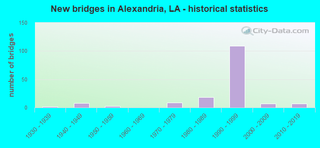
- New bridges - historical statistics
- 21930-1939
- 81940-1949
- 31950-1959
- 91970-1979
- 181980-1989
- 1091990-1999
- 72000-2009
- 72010-2019


- Bridge Condition - Deck
- 0.8%Very good
- 76.7%Good
- 14.0%Satisfactory
- 7.0%Fair
- 1.6%Poor

- Bridge Condition - Superstructure
- 0.8%Very good
- 69.0%Good
- 17.8%Satisfactory
- 8.5%Fair
- 2.3%Poor
- 1.6%Serious

- Bridge Condition - Substructure
- 2.3%Very good
- 69.8%Good
- 20.2%Satisfactory
- 3.1%Fair
- 1.6%Poor
- 1.6%Serious
- 1.6%Imminent failure
- 0.8%Failed

- Bridge Condition - Channel
- 12.5%Very good
- 50.0%Good
- 31.7%Satisfactory
- 3.8%Fair
- 1.9%Poor

- Bridge Condition - Culverts
- 92.9%Good
- 7.1%Satisfactory
Find on map >> Show street view
Structure Number: 84000000041152, Location: 3.0 MI. E OF US71 (Lat: 31.273881, Lng: -92.437831), Route carried "on" structure: State highway 1208, Year Built: 1975, Status: Open, Structure Length: 3.66m (12.01ft), Average Daily Traffic: 5,200 (year 2016), Truck Traffic: 8%, Average Future Daily Traffic: 6,760 (year 2036), Design Load: HS 20, Features Intersected: HORSESHOE CANAL
Minimum Vertical Clearance: 30+ m (98+ ft), Kilometerpoint: 0.105, Lanes on structure: 2, Owner: State Highway Agency, Approaching Roadway Width: 8.5m (27.9ft), Skew: 34 degrees, Material/Design: Concrete, Design/Construction: Slab, Number Of Spans In Main Unit: 6, Length of Maximum Span: 6.1m (20.0ft), Curb or Sidewalk Widths: Left: 0.0m, Right: 1.2m (3.9ft), Curb-To-Curb Width: 8.7m (28.5ft), Out-to-Out Width: 13.1m (43.0ft)
Condition: Deck: Satisfactory, Superstructure: Satisfactory, Substructure: Poor, Channel: Very good, Operating Rating: 37.3 metric tons, Method Used To Determine Operating Rating: Load and Resistance Factor Rating (LRFR) rating reported by rating factor(RF) method using HL-93 loadings, Inventory Rating: 28.8 metric tons, Method Used To Determine Inventory Rating: Load and Resistance Factor Rating (LRFR) rating reported by rating factor(RF) method using HL-93 loadings, Structural Evaluation: Meets minimum limits, Deck Geometry: High priority of replacement, Waterway Adequacy: Equal to present minimum criteria, Approach Roadway Alignment: Equal to present minimum criteria, Length Of Structure Improvement: 4.57m (14.99ft), Designated Inspection Frequency: Every 24 months, Other Special Inspection Frequency: Every 12 months, Inspection Date: December 2020, Other Special Inspection Date: December 2021, Bridge Improvement Cost: $390,000, Total Project Cost: $585,000 ( Estimate for 2016), Deck Structure Type: Concrete Precast Panels, Wearing Surface/Protective System: Wearing Surface: Bituminous
Find on map >> Show street view
Structure Number: 84000000080175, Location: 0.35 MI. SW OF LA 1 (Lat: 31.289600, Lng: -92.423600), Route carried "on" structure: State highway 1208, Year Built: 1994, Status: Open, Structure Length: 3.05m (10.01ft), Average Daily Traffic: 5,200 (year 2016), Truck Traffic: 8%, Average Future Daily Traffic: 6,760 (year 2036), Design Load: HS 20, Features Intersected: CHATLIN LAKE CANAL
Minimum Vertical Clearance: 30+ m (98+ ft), Kilometerpoint: 2.314, Lanes on structure: 2, Owner: State Highway Agency, Approaching Roadway Width: 8.5m (27.9ft), Skew: 30 degrees, Material/Design: Concrete, Design/Construction: Slab, Number Of Spans In Main Unit: 5, Length of Maximum Span: 7.0m (23.0ft), Curb or Sidewalk Widths: Left: 1.4m (4.6ft), Right: 1.4m (4.6ft), Curb-To-Curb Width: 8.5m (27.9ft), Out-to-Out Width: 11.9m (39.0ft)
Condition: Deck: Good, Superstructure: Good, Substructure: Good, Channel: Satisfactory, Operating Rating: 73.5 metric tons, Method Used To Determine Operating Rating: Load Factor (LF), Inventory Rating: 43.5 metric tons, Method Used To Determine Inventory Rating: Load Factor (LF), Structural Evaluation: Better than present minimum criteria, Deck Geometry: High priority of replacement, Waterway Adequacy: Equal to present desirable criteria, Approach Roadway Alignment: Equal to present desirable criteria, Length Of Structure Improvement: 3.90m (12.80ft), Designated Inspection Frequency: Every 24 months, Inspection Date: June 2020, Bridge Improvement Cost: $332,000, Total Project Cost: $498,000 ( Estimate for 2016), Deck Structure Type: Concrete Cast-file-Place, Wearing Surface/Protective System: Wearing Surface: Monolithic Concrete
Find on map >> Show street view
Structure Number: 84000000080176, Location: 3.45 MI. E OF US71 (Lat: 31.279081, Lng: -92.433100), Route carried "on" structure: State highway 1208, Year Built: 1994, Status: Open, Structure Length: 0.98m (3.22ft), Average Daily Traffic: 5,200 (year 2016), Truck Traffic: 8%, Average Future Daily Traffic: 6,760 (year 2036), Design Load: HS 20, Features Intersected: HYNSON BAYOU
Minimum Vertical Clearance: 30+ m (98+ ft), Kilometerpoint: 0.840, Lanes on structure: 2, Owner: State Highway Agency, Approaching Roadway Width: 8.5m (27.9ft), Skew: 30 degrees, Material/Design: Concrete, Design/Construction: Culvert, Number Of Spans In Main Unit: 3, Length of Maximum Span: 3.0m (9.8ft), Curb or Sidewalk Widths: Left: 1.2m (3.9ft), Right: 1.2m (3.9ft), Curb-To-Curb Width: 8.2m (26.9ft), Out-to-Out Width: 18.3m (60.0ft)
Condition: Channel: Satisfactory, Culverts: Good, Operating Rating: 45.4 metric tons, Method Used To Determine Operating Rating: Load and Resistance Factor Rating (LRFR) rating reported by rating factor(RF) method using HL-93 loadings, Inventory Rating: 35.0 metric tons, Method Used To Determine Inventory Rating: Load and Resistance Factor Rating (LRFR) rating reported by rating factor(RF) method using HL-93 loadings, Structural Evaluation: Better than present minimum criteria, Deck Geometry: High priority of replacement, Waterway Adequacy: Equal to present desirable criteria, Approach Roadway Alignment: Equal to present desirable criteria, Length Of Structure Improvement: 1.62m (5.31ft), Designated Inspection Frequency: Every 24 months, Inspection Date: June 2020, Bridge Improvement Cost: $137,000, Total Project Cost: $205,000 ( Estimate for 2016), Deck Structure Type: Concrete Cast-file-Place
Find on map >> Show street view
Structure Number: 84000000080584, Location: 1.1 MI. SOUTH OF LA 28 (Lat: 31.279619, Lng: -92.503700), Route carried "on" structure: County highway , Year Built: 2010, Status: Open, Structure Length: 1.92m (6.30ft), Average Daily Traffic: 10,800 (year 2020), Average Future Daily Traffic: 130 (year 2036), Design Load: HS 20, Features Intersected: Diversion Canal, Facility Carried by Structure: Versailles Blvd
Minimum Vertical Clearance: 30+ m (98+ ft), Kilometerpoint: 0.000, Lanes on structure: 3, Owner: City or Municipal Highway Agency, Approaching Roadway Width: 12.2m (40.0ft), Skew: 32 degrees, Material/Design: Concrete, Design/Construction: Culvert, Number Of Spans In Main Unit: 5, Length of Maximum Span: 3.7m (12.1ft), Curb or Sidewalk Widths: Left: 2.6m (8.5ft), Right: 2.6m (8.5ft), Curb-To-Curb Width: 12.0m (39.4ft), Out-to-Out Width: 34.1m (111.9ft)
Condition: Channel: Satisfactory, Culverts: Good, Operating Rating: 42.1 metric tons, Method Used To Determine Operating Rating: Load and Resistance Factor Rating (LRFR) rating reported by rating factor(RF) method using HL-93 loadings, Inventory Rating: 32.4 metric tons, Method Used To Determine Inventory Rating: Load and Resistance Factor Rating (LRFR) rating reported by rating factor(RF) method using HL-93 loadings, Structural Evaluation: Better than present minimum criteria, Deck Geometry: Meets minimum limits, Waterway Adequacy: Equal to present minimum criteria, Approach Roadway Alignment: Better than present minimum criteria, Designated Inspection Frequency: Every 24 months, Inspection Date: November 2021, Deck Structure Type: Concrete Precast Panels
Find on map >> Show street view
Structure Number: 84000000080588, Location: 0.01 MI. NORTH OF LA 486 (Lat: 31.313931, Lng: -92.527000), Route carried "on" structure: County highway , Year Built: 1955, Status: Posted for load, Structure Length: 5.21m (17.09ft), Design Load: HS 15, Features Intersected: BAYOU RAPIDES, Facility Carried by Structure: VANDENBURG DR
Minimum Vertical Clearance: 30+ m (98+ ft), Kilometerpoint: 2.031, Lanes on structure: 2, Owner: Local Agency, Approaching Roadway Width: 10.4m (34.1ft), Skew: 30 degrees, Material/Design: Concrete, Design/Construction: Tee Beam, Number Of Spans In Main Unit: 8, Length of Maximum Span: 7.0m (23.0ft), Curb-To-Curb Width: 10.4m (34.1ft), Out-to-Out Width: 11.6m (38.1ft)
Condition: Deck: Fair, Superstructure: Fair, Substructure: Fair, Channel: Satisfactory, Operating Rating: 31.4 metric tons, Method Used To Determine Operating Rating: Load and Resistance Factor Rating (LRFR) rating reported by rating factor(RF) method using HL-93 loadings, Inventory Rating: 25.3 metric tons, Method Used To Determine Inventory Rating: Load and Resistance Factor Rating (LRFR) rating reported by rating factor(RF) method using HL-93 loadings, Structural Evaluation: Somewhat better than minimum adequacy, Deck Geometry: Superior to present desirable criteria, Waterway Adequacy: Better than present minimum criteria, Approach Roadway Alignment: Equal to present minimum criteria, Bridge Posting: Required (Relationship of Operating Rating to Maximum Legal Load: 20.0 - 29.9% below), Designated Inspection Frequency: Every 24 months, Inspection Date: November 2021, Deck Structure Type: Concrete Cast-file-Place, Wearing Surface/Protective System: Wearing Surface: Monolithic Concrete
Find on map >> Show street view
Structure Number: 84000000080639, Location: 1.0 MILE NORTH OF I-49 (Lat: 31.327050, Lng: -92.457911), Route carried "on" structure: US 71, Year Built: 2015, Status: Open, Structure Length: 91.90m (301.51ft), Average Daily Traffic: 36,200 (year 2016), Truck Traffic: 14%, Average Future Daily Traffic: 46,540 (year 2036), Design Load: HL 93, Features Intersected: RED RIVER FORT BUHLOW
Minimum Vertical Clearance: 30+ m (98+ ft), Kilometerpoint: 2.005, Lanes on structure: 2, Base Highway Network: Yes (Inventory Route: 840-43-1, Subroute: 10), Owner: State Highway Agency, Approaching Roadway Width: 12.2m (40.0ft), Skew: 30 degrees, Navigation Control: Yes ( Vertical Clearance: 15.9m (52.2ft), Horizontal Clearance: 106.7m (350.1ft)), Material/Design: Steel continuous, Design/Construction: Stringer/Multi-beam, Number Of Spans In Main Unit: 3, Number Of Approach Spans: 18, Length of Maximum Span: 121.9m (399.9ft), Curb-To-Curb Width: 11.9m (39.0ft), Out-to-Out Width: 12.7m (41.7ft)
Condition: Deck: Very good, Superstructure: Very good, Substructure: Good, Channel: Good, Operating Rating: 37.6 metric tons, Method Used To Determine Operating Rating: Load and Resistance Factor Rating (LRFR) rating reported by rating factor(RF) method using HL-93 loadings, Inventory Rating: 28.8 metric tons, Method Used To Determine Inventory Rating: Load and Resistance Factor Rating (LRFR) rating reported by rating factor(RF) method using HL-93 loadings, Structural Evaluation: Better than present minimum criteria, Deck Geometry: Somewhat better than minimum adequacy, Waterway Adequacy: Superior to present desirable criteria, Approach Roadway Alignment: Superior to present desirable criteria, Designated Inspection Frequency: Every 24 months, Underwater Inspection Frequency: Every 60 months, Inspection Date: May 2021, Underwater Inspection Date: July 2021, Deck Structure Type: Concrete Cast-file-Place, Wearing Surface/Protective System: Wearing Surface: Monolithic Concrete
Find on map >> Show street view
Structure Number: 84000000080643, Location: 1.05 MI. NORTHEAST OF LA (Lat: 31.270961, Lng: -92.422800), Route carried "on" structure: County highway , Year Built: 2015, Status: Open, Structure Length: 3.66m (12.01ft), Average Daily Traffic: 900 (year 2020), Average Future Daily Traffic: 260 (year 2036), Design Load: HL 93, Features Intersected: Hynson Bayou, Facility Carried by Structure: Hudson Blvd
Minimum Vertical Clearance: 30+ m (98+ ft), Kilometerpoint: 0.000, Lanes on structure: 2, Owner: City or Municipal Highway Agency, Approaching Roadway Width: 7.3m (24.0ft), Skew: 30 degrees, Material/Design: Prestressed concrete, Design/Construction: Stringer/Multi-beam, Number Of Spans In Main Unit: 3, Length of Maximum Span: 12.2m (40.0ft), Curb-To-Curb Width: 8.8m (28.9ft), Out-to-Out Width: 9.9m (32.5ft)
Condition: Deck: Good, Superstructure: Good, Substructure: Good, Channel: Very good, Operating Rating: 55.4 metric tons, Method Used To Determine Operating Rating: Load and Resistance Factor Rating (LRFR) rating reported by rating factor(RF) method using HL-93 loadings, Inventory Rating: 27.2 metric tons, Method Used To Determine Inventory Rating: Load and Resistance Factor Rating (LRFR) rating reported by rating factor(RF) method using HL-93 loadings, Structural Evaluation: Equal to present minimum criteria, Deck Geometry: Somewhat better than minimum adequacy, Waterway Adequacy: Equal to present desirable criteria, Approach Roadway Alignment: Somewhat better than minimum adequacy, Designated Inspection Frequency: Every 24 months, Inspection Date: October 2021, Deck Structure Type: Concrete Cast-file-Place, Wearing Surface/Protective System: Wearing Surface: Monolithic Concrete
Find on map >> Show street view
Structure Number: 84000000080658, Location: 0.9 M SW OF LA 1 (Lat: 31.276050, Lng: -92.420339), Route carried "on" structure: County highway , Year Built: 2018, Status: Open, Structure Length: 3.66m (12.01ft), Average Daily Traffic: 176 (year 1997), Average Future Daily Traffic: 270 (year 2027), Design Load: HL 93, Features Intersected: CHATLIN LAKE CANAL, Facility Carried by Structure: HUDSON ROAD
Minimum Vertical Clearance: 30+ m (98+ ft), Kilometerpoint: 0.000, Lanes on structure: 2, Owner: City or Municipal Highway Agency, Approaching Roadway Width: 7.3m (24.0ft), Material/Design: Prestressed concrete, Design/Construction: Stringer/Multi-beam, Number Of Spans In Main Unit: 3, Length of Maximum Span: 12.2m (40.0ft), Curb-To-Curb Width: 8.8m (28.9ft), Out-to-Out Width: 9.9m (32.5ft)
Condition: Deck: Good, Superstructure: Good, Substructure: Good, Channel: Very good, Operating Rating: 49.9 metric tons, Method Used To Determine Operating Rating: Load and Resistance Factor Rating (LRFR) rating reported by rating factor(RF) method using HL-93 loadings, Inventory Rating: 27.2 metric tons, Method Used To Determine Inventory Rating: Load and Resistance Factor Rating (LRFR) rating reported by rating factor(RF) method using HL-93 loadings, Structural Evaluation: Equal to present minimum criteria, Deck Geometry: Equal to present minimum criteria, Waterway Adequacy: Equal to present desirable criteria, Approach Roadway Alignment: Equal to present minimum criteria, Designated Inspection Frequency: Every 24 months, Inspection Date: October 2021, Deck Structure Type: Concrete Cast-file-Place
Find on map >> Show street view
Structure Number: 84000000080664, Location: 1.0 MI N OF I-49 (Lat: 31.327111, Lng: -92.448411), Route carried "on" structure: US 71, Year Built: 2016, Status: Open, Structure Length: 91.59m (300.49ft), Average Daily Traffic: 18,100 (year 2016), Truck Traffic: 14%, Average Future Daily Traffic: 27,729 (year 2037), Design Load: HL 93, Features Intersected: RED RIVER FORT BUHLOW
Minimum Vertical Clearance: 30+ m (98+ ft), Kilometerpoint: 6.956, Lanes on structure: 2, Base Highway Network: Yes (Inventory Route: 840-43-2, Subroute: 10), Owner: State Highway Agency, Approaching Roadway Width: 12.2m (40.0ft), Skew: 30 degrees, Navigation Control: Yes ( Vertical Clearance: 15.9m (52.2ft), Horizontal Clearance: 115.8m (379.9ft)), Material/Design: Steel continuous, Design/Construction: Stringer/Multi-beam, Number Of Spans In Main Unit: 3, Number Of Approach Spans: 18, Length of Maximum Span: 121.9m (399.9ft), Curb-To-Curb Width: 12.0m (39.4ft), Out-to-Out Width: 12.6m (41.3ft)
Condition: Deck: Good, Superstructure: Good, Substructure: Good, Channel: Good, Operating Rating: 42.1 metric tons, Method Used To Determine Operating Rating: Load and Resistance Factor Rating (LRFR) rating reported by rating factor(RF) method using HL-93 loadings, Inventory Rating: 32.4 metric tons, Method Used To Determine Inventory Rating: Load and Resistance Factor Rating (LRFR) rating reported by rating factor(RF) method using HL-93 loadings, Structural Evaluation: Better than present minimum criteria, Deck Geometry: Better than present minimum criteria, Waterway Adequacy: Superior to present desirable criteria, Approach Roadway Alignment: Superior to present desirable criteria, Designated Inspection Frequency: Every 24 months, Inspection Date: May 2021, Deck Structure Type: Concrete Cast-file-Place, Wearing Surface/Protective System: Wearing Surface: Monolithic Concrete
Find on map >> Show street view
Structure Number: 84000000600439, Location: 0.59 MI. W. OF END LA 120 (Lat: 31.375939, Lng: -92.489800), Route carried "on" structure: County highway , Year Built: 2012, Status: Open, Structure Length: 8.38m (27.49ft), Average Daily Traffic: 1,614 (year 2011), Average Future Daily Traffic: 2,098 (year 2036), Design Load: HS 20, Features Intersected: RIGOLETTE BAYOU, Facility Carried by Structure: Rigolette Rd
Minimum Vertical Clearance: 30+ m (98+ ft), Kilometerpoint: 3.822, Lanes on structure: 2, Owner: County Highway Agency, Approaching Roadway Width: 8.5m (27.9ft), Skew: 30 degrees, Material/Design: Concrete, Design/Construction: Slab, Number Of Spans In Main Unit: 11, Length of Maximum Span: 7.6m (24.9ft), Curb-To-Curb Width: 7.2m (23.6ft), Out-to-Out Width: 8.2m (26.9ft)
Condition: Deck: Satisfactory, Superstructure: Satisfactory, Substructure: Satisfactory, Channel: Satisfactory, Operating Rating: 67.4 metric tons, Method Used To Determine Operating Rating: Load and Resistance Factor Rating (LRFR) rating reported by rating factor(RF) method using HL-93 loadings, Inventory Rating: 52.2 metric tons, Method Used To Determine Inventory Rating: Load and Resistance Factor Rating (LRFR) rating reported by rating factor(RF) method using HL-93 loadings, Structural Evaluation: Equal to present minimum criteria, Deck Geometry: High priority of corrective action, Waterway Adequacy: Somewhat better than minimum adequacy, Approach Roadway Alignment: Equal to present minimum criteria, Designated Inspection Frequency: Every 24 months, Underwater Inspection Frequency: Every 60 months, Inspection Date: November 2021, Underwater Inspection Date: April 2018, Deck Structure Type: Concrete Precast Panels, Wearing Surface/Protective System: Wearing Surface: Monolithic Concrete
Find on map >> Show street view
Structure Number: 84000000800005, Location: 0.31 M S of La 1 (Lat: 31.343161, Lng: -92.537669), Route carried "on" structure: County highway , Year Built: 2018, Status: Open, Structure Length: 3.66m (12.01ft), Average Daily Traffic: 270 (year 2019), Average Future Daily Traffic: 351 (year 2036), Design Load: HL 93, Features Intersected: Big Bayou, Facility Carried by Structure: Harold Miles Park
Minimum Vertical Clearance: 30+ m (98+ ft), Kilometerpoint: 0.000, Lanes on structure: 2, Owner: Local Agency, Approaching Roadway Width: 7.3m (24.0ft), Material/Design: Prestressed concrete, Design/Construction: Stringer/Multi-beam, Number Of Spans In Main Unit: 3, Length of Maximum Span: 12.2m (40.0ft), Curb-To-Curb Width: 7.2m (23.6ft), Out-to-Out Width: 8.1m (26.6ft)
Condition: Deck: Good, Superstructure: Good, Substructure: Good, Channel: Good, Operating Rating: 64.8 metric tons, Method Used To Determine Operating Rating: Load and Resistance Factor Rating (LRFR) rating reported by rating factor(RF) method using HL-93 loadings, Inventory Rating: 38.9 metric tons, Method Used To Determine Inventory Rating: Load and Resistance Factor Rating (LRFR) rating reported by rating factor(RF) method using HL-93 loadings, Structural Evaluation: Better than present minimum criteria, Deck Geometry: Meets minimum limits, Waterway Adequacy: Equal to present desirable criteria, Approach Roadway Alignment: Better than present minimum criteria, Designated Inspection Frequency: Every 24 months, Inspection Date: October 2021, Deck Structure Type: Concrete Cast-file-Place, Wearing Surface/Protective System: Wearing Surface: Monolithic Concrete
Find on map >> Show street view
Structure Number: 84000080911661, Location: 2.15 MI. NORTH OF LA 3170 (Lat: 31.212531, Lng: -92.425300), Route carried "on" structure: US 71, Year Built: 1973, Status: Open, Structure Length: 0.88m (2.89ft), Average Daily Traffic: 16,000 (year 2016), Truck Traffic: 15%, Average Future Daily Traffic: 20,410 (year 2036), Design Load: HS 20, Features Intersected: DRAINAGE DITCH
Minimum Vertical Clearance: 30+ m (98+ ft), Kilometerpoint: 18.765, Lanes on structure: 6, Base Highway Network: Yes (Inventory Route: 8-09-1, Subroute: 10), Owner: State Highway Agency, Approaching Roadway Width: 29.3m (96.1ft), Skew: 31 degrees, Material/Design: Steel, Design/Construction: Culvert, Number Of Spans In Main Unit: 4, Length of Maximum Span: 1.5m (4.9ft)
Condition: Channel: Satisfactory, Culverts: Satisfactory, Operating Rating: 66.7 metric tons, Method Used To Determine Operating Rating: Load and Resistance Factor Rating (LRFR) rating reported by rating factor(RF) method using HL-93 loadings, Inventory Rating: 51.5 metric tons, Method Used To Determine Inventory Rating: Load and Resistance Factor Rating (LRFR) rating reported by rating factor(RF) method using HL-93 loadings, Structural Evaluation: Equal to present minimum criteria, Waterway Adequacy: Better than present minimum criteria, Approach Roadway Alignment: Equal to present desirable criteria, Designated Inspection Frequency: Every 24 months, Inspection Date: March 2020
Find on map >> Show street view
Structure Number: 84000080913921, Location: 4.41 MI. NORTH OF LA 3170 (Lat: 31.241531, Lng: -92.429950), Route carried "on" structure: US 71, Year Built: 1989, Status: Open, Structure Length: 0.76m (2.49ft), Average Daily Traffic: 8,000 (year 2016), Truck Traffic: 14%, Average Future Daily Traffic: 12,246 (year 2036), Design Load: HS 20, Features Intersected: DITCH
Minimum Vertical Clearance: 5.11m (16.77ft), Kilometerpoint: 21.683, Lanes on structure: 2, Base Highway Network: Yes (Inventory Route: 8-09-1, Subroute: 10), Owner: State Highway Agency, Approaching Roadway Width: 12.2m (40.0ft), Skew: 30 degrees, Material/Design: Concrete, Design/Construction: Slab, Number Of Spans In Main Unit: 1, Length of Maximum Span: 7.6m (24.9ft), Curb-To-Curb Width: 12.2m (40.0ft), Out-to-Out Width: 13.0m (42.7ft)
Condition: Deck: Good, Superstructure: Good, Substructure: Very good, Channel: Very good, Operating Rating: 72.6 metric tons, Method Used To Determine Operating Rating: Load Factor (LF), Inventory Rating: 43.5 metric tons, Method Used To Determine Inventory Rating: Load Factor (LF), Structural Evaluation: Better than present minimum criteria, Deck Geometry: Better than present minimum criteria, Waterway Adequacy: Better than present minimum criteria, Approach Roadway Alignment: Better than present minimum criteria, Designated Inspection Frequency: Every 24 months, Inspection Date: Febuary 2020, Deck Structure Type: Concrete Cast-file-Place, Wearing Surface/Protective System: Wearing Surface: Monolithic Concrete
Find on map >> Show street view
Structure Number: 84000080913922, Location: 4.41 MI. NORTH OF LA 3170 (Lat: 31.241619, Lng: -92.430139), Route carried "on" structure: US 71, Year Built: 1989, Status: Open, Structure Length: 0.76m (2.49ft), Average Daily Traffic: 8,000 (year 2016), Truck Traffic: 14%, Average Future Daily Traffic: 12,246 (year 2036), Design Load: HS 20, Features Intersected: DITCH
Minimum Vertical Clearance: 30+ m (98+ ft), Kilometerpoint: 5.988, Lanes on structure: 2, Base Highway Network: Yes (Inventory Route: 8-09-2, Subroute: 10), Owner: State Highway Agency, Approaching Roadway Width: 12.2m (40.0ft), Skew: 30 degrees, Material/Design: Concrete, Design/Construction: Slab, Number Of Spans In Main Unit: 1, Length of Maximum Span: 7.6m (24.9ft), Curb-To-Curb Width: 12.2m (40.0ft), Out-to-Out Width: 13.0m (42.7ft)
Condition: Deck: Good, Superstructure: Good, Substructure: Very good, Channel: Good, Operating Rating: 72.6 metric tons, Method Used To Determine Operating Rating: Load Factor (LF), Inventory Rating: 43.5 metric tons, Method Used To Determine Inventory Rating: Load Factor (LF), Structural Evaluation: Better than present minimum criteria, Deck Geometry: Better than present minimum criteria, Waterway Adequacy: Better than present minimum criteria, Approach Roadway Alignment: Better than present minimum criteria, Designated Inspection Frequency: Every 24 months, Inspection Date: Febuary 2020, Deck Structure Type: Concrete Cast-file-Place, Wearing Surface/Protective System: Wearing Surface: Monolithic Concrete
Find on map >> Show street view
Structure Number: 84000080914421, Location: .3 MI. N OF INT I-49 (Lat: 31.248150, Lng: -92.433500), Route carried "on" structure: US 71, Year Built: 2003, Status: Open, Structure Length: 15.94m (52.30ft), Average Daily Traffic: 8,000 (year 2016), Truck Traffic: 14%, Average Future Daily Traffic: 12,246 (year 2036), Design Load: HS 20, Features Intersected: UP RAILROAD
Minimum Vertical Clearance: 30+ m (98+ ft), Kilometerpoint: 22.532, Lanes on structure: 3, Base Highway Network: Yes (Inventory Route: 8-09-1, Subroute: 10), Owner: State Highway Agency, Approaching Roadway Width: 15.9m (52.2ft), Skew: 33 degrees, Material/Design: Prestressed concrete continuous, Design/Construction: Stringer/Multi-beam, Number Of Spans In Main Unit: 6, Length of Maximum Span: 33.5m (109.9ft), Curb-To-Curb Width: 15.9m (52.2ft), Out-to-Out Width: 16.6m (54.5ft)
Condition: Deck: Good, Superstructure: Good, Substructure: Good, Operating Rating: 29.8 metric tons, Method Used To Determine Operating Rating: Load and Resistance Factor Rating (LRFR) rating reported by rating factor(RF) method using HL-93 loadings, Inventory Rating: 23.0 metric tons, Method Used To Determine Inventory Rating: Load and Resistance Factor Rating (LRFR) rating reported by rating factor(RF) method using HL-93 loadings, Structural Evaluation: Somewhat better than minimum adequacy, Deck Geometry: Better than present minimum criteria, Underclear: Meets minimum limits, Approach Roadway Alignment: Equal to present desirable criteria, Designated Inspection Frequency: Every 24 months, Inspection Date: May 2020, Deck Structure Type: Concrete Cast-file-Place, Wearing Surface/Protective System: Wearing Surface: Monolithic Concrete
Find on map >> Show street view
Structure Number: 84000080914422, Location: .3 MI. N OF INT I-49 (Lat: 31.248961, Lng: -92.434700), Route carried "on" structure: US 71, Year Built: 1974, Status: Open, Structure Length: 16.86m (55.31ft), Average Daily Traffic: 8,000 (year 2016), Truck Traffic: 14%, Average Future Daily Traffic: 12,246 (year 2036), Design Load: HS 20, Features Intersected: UP RAILROAD
Minimum Vertical Clearance: 30+ m (98+ ft), Kilometerpoint: 5.026, Lanes on structure: 2, Base Highway Network: Yes (Inventory Route: 8-09-2, Subroute: 10), Owner: State Highway Agency, Approaching Roadway Width: 12.2m (40.0ft), Skew: 34 degrees, Material/Design: Steel, Design/Construction: Stringer/Multi-beam, Number Of Spans In Main Unit: 6, Length of Maximum Span: 30.5m (100.1ft), Curb-To-Curb Width: 11.9m (39.0ft), Out-to-Out Width: 13.0m (42.7ft)
Condition: Deck: Satisfactory, Superstructure: Poor, Substructure: Satisfactory, Operating Rating: 89.8 metric tons, Method Used To Determine Operating Rating: Load Factor (LF), Inventory Rating: 53.5 metric tons, Method Used To Determine Inventory Rating: Load Factor (LF), Structural Evaluation: Meets minimum limits, Deck Geometry: Better than present minimum criteria, Underclear: Equal to present minimum criteria, Approach Roadway Alignment: Equal to present minimum criteria, Designated Inspection Frequency: Every 12 months, Inspection Date: May 2021, Deck Structure Type: Concrete Cast-file-Place, Wearing Surface/Protective System: Wearing Surface: Monolithic Concrete
Find on map >> Show street view
Structure Number: 84000080916611, Location: 1.11 MI. NE OF US 71 (Lat: 31.273069, Lng: -92.445331), Route carried "on" structure: Business US 167, Year Built: 1958, Status: Open, Structure Length: 3.66m (12.01ft), Average Daily Traffic: 25,900 (year 2016), Truck Traffic: 14%, Average Future Daily Traffic: 32,890 (year 2036), Design Load: HS 20, Features Intersected: HORSESHOE CANAL
Minimum Vertical Clearance: 30+ m (98+ ft), Kilometerpoint: 26.023, Lanes on structure: 4, Base Highway Network: Yes (Inventory Route: 8-09-1, Subroute: 10), Owner: State Highway Agency, Approaching Roadway Width: 13.7m (44.9ft), Skew: 30 degrees, Material/Design: Concrete, Design/Construction: Slab, Number Of Spans In Main Unit: 6, Length of Maximum Span: 6.1m (20.0ft), Curb or Sidewalk Widths: Left: 1.5m (4.9ft), Right: 1.5m (4.9ft), Curb-To-Curb Width: 13.7m (44.9ft), Out-to-Out Width: 16.8m (55.1ft)
Condition: Deck: Good, Superstructure: Good, Substructure: Satisfactory, Channel: Good, Operating Rating: 36.3 metric tons, Method Used To Determine Operating Rating: Load Factor (LF), Inventory Rating: 21.8 metric tons, Method Used To Determine Inventory Rating: Load Factor (LF), Structural Evaluation: Somewhat better than minimum adequacy, Deck Geometry: High priority of replacement, Waterway Adequacy: Equal to present minimum criteria, Approach Roadway Alignment: Better than present minimum criteria, Length Of Structure Improvement: 4.57m (14.99ft), Designated Inspection Frequency: Every 24 months, Inspection Date: March 2020, Bridge Improvement Cost: $438,000, Total Project Cost: $657,000 ( Estimate for 2016), Deck Structure Type: Concrete Cast-file-Place, Wearing Surface/Protective System: Wearing Surface: Bituminous
Find on map >> Show street view
Structure Number: 84000083001051, Location: 0.73 MI. N. OF LA 1208-2 (Lat: 31.271311, Lng: -92.463089), Route carried "on" structure: US 71, Year Built: 1944, Status: Open, Structure Length: 1.46m (4.79ft), Average Daily Traffic: 19,300 (year 2016), Truck Traffic: 14%, Average Future Daily Traffic: 24,830 (year 2036), Design Load: H 15, Features Intersected: DIVERSION CANAL
Minimum Vertical Clearance: 30+ m (98+ ft), Kilometerpoint: 1.690, Lanes on structure: 8, Base Highway Network: Yes (Inventory Route: 8-30-1, Subroute: 10), Owner: State Highway Agency, Approaching Roadway Width: 36.6m (120.1ft), Skew: 34 degrees, Material/Design: Concrete, Design/Construction: Culvert, Number Of Spans In Main Unit: 3, Length of Maximum Span: 3.0m (9.8ft), Curb-To-Curb Width: 24.4m (80.1ft), Out-to-Out Width: 80.8m (265.1ft)
Condition: Channel: Good, Culverts: Good, Operating Rating: 42.1 metric tons, Method Used To Determine Operating Rating: Load and Resistance Factor Rating (LRFR) rating reported by rating factor(RF) method using HL-93 loadings, Inventory Rating: 32.4 metric tons, Method Used To Determine Inventory Rating: Load and Resistance Factor Rating (LRFR) rating reported by rating factor(RF) method using HL-93 loadings, Structural Evaluation: Better than present minimum criteria, Deck Geometry: High priority of replacement, Waterway Adequacy: Equal to present minimum criteria, Approach Roadway Alignment: Better than present minimum criteria, Length Of Structure Improvement: 2.13m (6.99ft), Designated Inspection Frequency: Every 24 months, Inspection Date: March 2020, Bridge Improvement Cost: $364,000, Total Project Cost: $546,000 ( Estimate for 2016), Deck Structure Type: Concrete Cast-file-Place
Find on map >> Show street view
Structure Number: 84000083002551, Location: US 71/LA 1208-3 INTG. (Lat: 31.285911, Lng: -92.474600), Route carried "on" structure: US 71, Year Built: 1972, Status: Open, Structure Length: 9.39m (30.81ft), Average Daily Traffic: 39,100 (year 2016), Truck Traffic: 14%, Average Future Daily Traffic: 49,920 (year 2036), Design Load: HS 20, Features Intersected: LA 1208-3
Minimum Vertical Clearance: 30+ m (98+ ft), Kilometerpoint: 3.891, Lanes on structure: 4, Lanes under structure: 6, Base Highway Network: Yes (Inventory Route: 8-30-1, Subroute: 10), Owner: State Highway Agency, Approaching Roadway Width: 24.4m (80.1ft), Skew: 33 degrees, Material/Design: Steel, Design/Construction: Stringer/Multi-beam, Number Of Spans In Main Unit: 3, Length of Maximum Span: 39.0m (128.0ft), Curb-To-Curb Width: 24.4m (80.1ft), Out-to-Out Width: 25.9m (85.0ft)
Condition: Deck: Fair, Superstructure: Satisfactory, Substructure: Good, Operating Rating: 63.5 metric tons, Method Used To Determine Operating Rating: Load Factor (LF), Inventory Rating: 38.1 metric tons, Method Used To Determine Inventory Rating: Load Factor (LF), Structural Evaluation: Equal to present minimum criteria, Deck Geometry: Superior to present desirable criteria, Underclear: Equal to present minimum criteria, Approach Roadway Alignment: Better than present minimum criteria, Designated Inspection Frequency: Every 24 months, Inspection Date: March 2020, Deck Structure Type: Concrete Cast-file-Place, Wearing Surface/Protective System: Wearing Surface: Monolithic Concrete
Find on map >> Show street view
Structure Number: 84000083003891, Location: 0.17 MI. NORTH OF LA 496 (Lat: 31.306019, Lng: -92.479300), Route carried "on" structure: US 71, Year Built: 1944, Year Reconstructed: 1990, Status: Open, Structure Length: 1.62m (5.31ft), Average Daily Traffic: 2,970 (year 2016), Truck Traffic: 14%, Average Future Daily Traffic: 38,220 (year 2036), Design Load: H 15, Features Intersected: BAYOU RAPIDES
Minimum Vertical Clearance: 30+ m (98+ ft), Kilometerpoint: 2.234, Lanes on structure: 8, Base Highway Network: Yes (Inventory Route: 8-30-3, Subroute: 30), Owner: State Highway Agency, Approaching Roadway Width: 39.0m (128.0ft), Skew: 32 degrees, Material/Design: Concrete, Design/Construction: Culvert, Number Of Spans In Main Unit: 3, Length of Maximum Span: 5.2m (17.1ft)
Condition: Channel: Good, Culverts: Good, Operating Rating: 42.1 metric tons, Method Used To Determine Operating Rating: Load and Resistance Factor Rating (LRFR) rating reported by rating factor(RF) method using HL-93 loadings, Inventory Rating: 32.4 metric tons, Method Used To Determine Inventory Rating: Load and Resistance Factor Rating (LRFR) rating reported by rating factor(RF) method using HL-93 loadings, Structural Evaluation: Better than present minimum criteria, Waterway Adequacy: Equal to present minimum criteria, Approach Roadway Alignment: Equal to present minimum criteria, Designated Inspection Frequency: Every 24 months, Inspection Date: March 2020, Deck Structure Type: Concrete Cast-file-Place
Find on map >> Show street view
Structure Number: 84000140505501, Location: 0.19 MI. SOUTH OF LA 113 (Lat: 30.973800, Lng: -92.586261), Route carried "on" structure: US 165, Year Built: 2005, Status: Open, Structure Length: 0.73m (2.40ft), Average Daily Traffic: 7,400 (year 2016), Truck Traffic: 15%, Average Future Daily Traffic: 9,620 (year 2036), Design Load: HS 20, Features Intersected: DITCH
Minimum Vertical Clearance: 30+ m (98+ ft), Kilometerpoint: 8.851, Lanes on structure: 5, Base Highway Network: Yes (Inventory Route: 14-05-1, Subroute: 10), Owner: State Highway Agency, Approaching Roadway Width: 19.8m (65.0ft), Skew: 37 degrees, Material/Design: Concrete, Design/Construction: Culvert, Number Of Spans In Main Unit: 5, Length of Maximum Span: 1.2m (3.9ft)
Condition: Channel: Satisfactory, Culverts: Good, Operating Rating: 42.1 metric tons, Method Used To Determine Operating Rating: Load and Resistance Factor Rating (LRFR) rating reported by rating factor(RF) method using HL-93 loadings, Inventory Rating: 32.4 metric tons, Method Used To Determine Inventory Rating: Load and Resistance Factor Rating (LRFR) rating reported by rating factor(RF) method using HL-93 loadings, Structural Evaluation: Better than present minimum criteria, Waterway Adequacy: Equal to present desirable criteria, Approach Roadway Alignment: Equal to present desirable criteria, Designated Inspection Frequency: Every 24 months, Inspection Date: July 2020, Deck Structure Type: Concrete Precast Panels
Find on map >> Show street view
Structure Number: 84000140609771, Location: 5.87 MI. NORTH OF LA 3265 (Lat: 31.227461, Lng: -92.497300), Route carried "on" structure: US 165, Year Built: 1994, Status: Open, Structure Length: 5.49m (18.01ft), Average Daily Traffic: 4,850 (year 2016), Truck Traffic: 15%, Average Future Daily Traffic: 7,488 (year 2036), Design Load: HS 20, Features Intersected: DIVERSION CANAL
Minimum Vertical Clearance: 30+ m (98+ ft), Kilometerpoint: 15.585, Lanes on structure: 2, Base Highway Network: Yes (Inventory Route: 14-06-1, Subroute: 10), Owner: State Highway Agency, Approaching Roadway Width: 12.2m (40.0ft), Skew: 36 degrees, Material/Design: Concrete, Design/Construction: Slab, Number Of Spans In Main Unit: 9, Length of Maximum Span: 6.1m (20.0ft), Curb-To-Curb Width: 12.2m (40.0ft), Out-to-Out Width: 13.1m (43.0ft)
Condition: Deck: Good, Superstructure: Good, Substructure: Satisfactory, Channel: Satisfactory, Operating Rating: 68.0 metric tons, Method Used To Determine Operating Rating: Load Factor (LF), Inventory Rating: 39.9 metric tons, Method Used To Determine Inventory Rating: Load Factor (LF), Structural Evaluation: Equal to present minimum criteria, Deck Geometry: Better than present minimum criteria, Waterway Adequacy: Better than present minimum criteria, Approach Roadway Alignment: Better than present minimum criteria, Designated Inspection Frequency: Every 24 months, Inspection Date: August 2020, Deck Structure Type: Concrete Cast-file-Place, Wearing Surface/Protective System: Wearing Surface: Monolithic Concrete
Find on map >> Show street view
Structure Number: 84000140609772, Location: 5.87 MI. NORTH OF LA 3265 (Lat: 31.228139, Lng: -92.497100), Route carried "on" structure: US 165, Year Built: 1993, Status: Open, Structure Length: 5.49m (18.01ft), Average Daily Traffic: 4,850 (year 2016), Truck Traffic: 15%, Average Future Daily Traffic: 7,488 (year 2036), Design Load: HS 20, Features Intersected: DIVERSION CANAL
Minimum Vertical Clearance: 30+ m (98+ ft), Kilometerpoint: 5.718, Lanes on structure: 2, Base Highway Network: Yes (Inventory Route: 14-06-2, Subroute: 10), Owner: State Highway Agency, Approaching Roadway Width: 12.2m (40.0ft), Skew: 36 degrees, Material/Design: Concrete, Design/Construction: Slab, Number Of Spans In Main Unit: 9, Length of Maximum Span: 6.1m (20.0ft), Curb-To-Curb Width: 12.2m (40.0ft), Out-to-Out Width: 13.0m (42.7ft)
Condition: Deck: Good, Superstructure: Good, Substructure: Good, Channel: Satisfactory, Operating Rating: 68.0 metric tons, Method Used To Determine Operating Rating: Load Factor (LF), Inventory Rating: 40.8 metric tons, Method Used To Determine Inventory Rating: Load Factor (LF), Structural Evaluation: Better than present minimum criteria, Deck Geometry: Better than present minimum criteria, Waterway Adequacy: Superior to present desirable criteria, Approach Roadway Alignment: Better than present minimum criteria, Designated Inspection Frequency: Every 24 months, Inspection Date: August 2020, Deck Structure Type: Concrete Cast-file-Place, Wearing Surface/Protective System: Wearing Surface: Monolithic Concrete
Find on map >> Show street view
Structure Number: 84000140610471, Location: 6.57 MI. NORTH OF LA 3265 (Lat: 31.236211, Lng: -92.491600), Route carried "on" structure: US 165, Year Built: 1994, Status: Open, Structure Length: 4.27m (14.01ft), Average Daily Traffic: 4,850 (year 2016), Truck Traffic: 14%, Average Future Daily Traffic: 7,488 (year 2036), Design Load: HS 20, Features Intersected: PECAN BAYOU
Minimum Vertical Clearance: 30+ m (98+ ft), Kilometerpoint: 16.695, Lanes on structure: 2, Base Highway Network: Yes (Inventory Route: 14-06-1, Subroute: 10), Owner: State Highway Agency, Approaching Roadway Width: 12.2m (40.0ft), Skew: 30 degrees, Material/Design: Concrete, Design/Construction: Slab, Number Of Spans In Main Unit: 7, Length of Maximum Span: 6.1m (20.0ft), Curb-To-Curb Width: 12.2m (40.0ft), Out-to-Out Width: 13.1m (43.0ft)
Condition: Deck: Good, Superstructure: Good, Substructure: Satisfactory, Channel: Satisfactory, Operating Rating: 68.0 metric tons, Method Used To Determine Operating Rating: Load Factor (LF), Inventory Rating: 39.9 metric tons, Method Used To Determine Inventory Rating: Load Factor (LF), Structural Evaluation: Equal to present minimum criteria, Deck Geometry: Better than present minimum criteria, Waterway Adequacy: Equal to present desirable criteria, Approach Roadway Alignment: Equal to present desirable criteria, Designated Inspection Frequency: Every 24 months, Inspection Date: August 2020, Deck Structure Type: Concrete Cast-file-Place, Wearing Surface/Protective System: Wearing Surface: Monolithic Concrete
Find on map >> Show street view
Structure Number: 84000140610472, Location: 6.57 MI. NORTH OF LA 3265 (Lat: 31.236661, Lng: -92.491600), Route carried "on" structure: US 165, Year Built: 1993, Status: Open, Structure Length: 4.27m (14.01ft), Average Daily Traffic: 4,850 (year 2016), Truck Traffic: 14%, Average Future Daily Traffic: 7,488 (year 2036), Design Load: HS 20, Features Intersected: PECAN BAYOU
Minimum Vertical Clearance: 30+ m (98+ ft), Kilometerpoint: 4.638, Lanes on structure: 2, Base Highway Network: Yes (Inventory Route: 14-06-2, Subroute: 10), Owner: State Highway Agency, Approaching Roadway Width: 12.2m (40.0ft), Skew: 30 degrees, Material/Design: Concrete, Design/Construction: Slab, Number Of Spans In Main Unit: 7, Length of Maximum Span: 6.1m (20.0ft), Curb-To-Curb Width: 12.2m (40.0ft), Out-to-Out Width: 13.0m (42.7ft)
Condition: Deck: Good, Superstructure: Good, Substructure: Good, Channel: Satisfactory, Operating Rating: 68.0 metric tons, Method Used To Determine Operating Rating: Load Factor (LF), Inventory Rating: 40.8 metric tons, Method Used To Determine Inventory Rating: Load Factor (LF), Structural Evaluation: Better than present minimum criteria, Deck Geometry: Better than present minimum criteria, Waterway Adequacy: Equal to present desirable criteria, Approach Roadway Alignment: Better than present minimum criteria, Designated Inspection Frequency: Every 24 months, Inspection Date: August 2020, Deck Structure Type: Concrete Cast-file-Place, Wearing Surface/Protective System: Wearing Surface: Monolithic Concrete
Find on map >> Show street view
Structure Number: 84000140613241, Location: 1.06 M S OF TRAFFIC CIRCL (Lat: 31.271439, Lng: -92.468800), Route carried "on" structure: US 165, Year Built: 1944, Status: Open, Structure Length: 0.64m (2.10ft), Average Daily Traffic: 17,200 (year 2016), Truck Traffic: 14%, Average Future Daily Traffic: 22,230 (year 2036), Design Load: HS 20, Features Intersected: DIVERSION CANAL
Minimum Vertical Clearance: 30+ m (98+ ft), Kilometerpoint: 21.168, Lanes on structure: 8, Base Highway Network: Yes (Inventory Route: 14-06-1, Subroute: 10), Owner: State Highway Agency, Approaching Roadway Width: 35.1m (115.2ft), Skew: 30 degrees, Material/Design: Concrete, Design/Construction: Culvert, Number Of Spans In Main Unit: 2, Length of Maximum Span: 3.0m (9.8ft), Curb-To-Curb Width: 22.9m (75.1ft), Out-to-Out Width: 82.9m (272.0ft)
Condition: Channel: Satisfactory, Culverts: Satisfactory, Operating Rating: 42.1 metric tons, Method Used To Determine Operating Rating: Load and Resistance Factor Rating (LRFR) rating reported by rating factor(RF) method using HL-93 loadings, Inventory Rating: 32.4 metric tons, Method Used To Determine Inventory Rating: Load and Resistance Factor Rating (LRFR) rating reported by rating factor(RF) method using HL-93 loadings, Structural Evaluation: Equal to present minimum criteria, Deck Geometry: High priority of replacement, Waterway Adequacy: Better than present minimum criteria, Approach Roadway Alignment: Better than present minimum criteria, Length Of Structure Improvement: 1.25m (4.10ft), Designated Inspection Frequency: Every 24 months, Inspection Date: August 2020, Bridge Improvement Cost: $199,000, Total Project Cost: $298,000 ( Estimate for 2016), Deck Structure Type: Concrete Cast-file-Place
Find on map >> Show street view
Structure Number: 84000150100111, Location: 0.11 M E OF INT LA 1208-3 (Lat: 31.313061, Lng: -92.445200), Route carried "on" structure: Business US 165, Year Built: 1985, Status: Open, Structure Length: 31.36m (102.89ft), Average Daily Traffic: 7,800 (year 2016), Truck Traffic: 4%, Average Future Daily Traffic: 10,140 (year 2036), Design Load: HS 20, Features Intersected: RED RIVER, CITY STS.
Minimum Vertical Clearance: 5.05m (16.57ft), Kilometerpoint: 0.013, Lanes on structure: 2, Lanes under structure: 4, Owner: State Highway Agency, Approaching Roadway Width: 11.0m (36.1ft), Skew: 30 degrees, Navigation Control: Yes ( Vertical Clearance: 19.5m (64.0ft), Horizontal Clearance: 86.3m (283.1ft)), Material/Design: Steel, Design/Construction: Movable - Lift, Number Of Spans In Main Unit: 1, Number Of Approach Spans: 8, Length of Maximum Span: 91.4m (299.9ft), Curb or Sidewalk Widths: Left: 0.0m, Right: 1.2m (3.9ft), Curb-To-Curb Width: 10.7m (35.1ft), Out-to-Out Width: 11.7m (38.4ft)
Condition: Deck: Good, Superstructure: Satisfactory, Substructure: Satisfactory, Channel: Very good, Operating Rating: 21.1 metric tons, Method Used To Determine Operating Rating: Load and Resistance Factor Rating (LRFR) rating reported by rating factor(RF) method using HL-93 loadings, Inventory Rating: 16.2 metric tons, Method Used To Determine Inventory Rating: Load and Resistance Factor Rating (LRFR) rating reported by rating factor(RF) method using HL-93 loadings, Structural Evaluation: Meets minimum limits, Deck Geometry: Meets minimum limits, Underclear: Superior to present desirable criteria, Waterway Adequacy: Equal to present desirable criteria, Approach Roadway Alignment: Equal to present minimum criteria, Designated Inspection Frequency: Every 24 months, Critical Feature Inspection Frequency: Every 24 months, Underwater Inspection Frequency: Every 60 months, Inspection Date: May 2021, Critical Feature Inspection Date: May 2021, Underwater Inspection Date: July 2021, Deck Structure Type: Open Grating
Find on map >> Show street view
Structure Number: 84000153001441, Location: 1.44 MI. N OF INT US71 (Lat: 31.349500, Lng: -92.426700), Route carried "on" structure: US 165, Year Built: 1997, Status: Open, Structure Length: 6.86m (22.51ft), Average Daily Traffic: 19,700 (year 2016), Truck Traffic: 14%, Average Future Daily Traffic: 50,050 (year 2036), Design Load: HS 20, Features Intersected: LA. & ARKANSAS RR
Minimum Vertical Clearance: 30+ m (98+ ft), Kilometerpoint: 2.189, Lanes on structure: 2, Base Highway Network: Yes (Inventory Route: 15-30-1, Subroute: 10), Owner: State Highway Agency, Approaching Roadway Width: 11.6m (38.1ft), Skew: 6 degrees, Material/Design: Prestressed concrete continuous, Design/Construction: Stringer/Multi-beam, Number Of Spans In Main Unit: 3, Length of Maximum Span: 25.9m (85.0ft), Curb-To-Curb Width: 12.2m (40.0ft), Out-to-Out Width: 13.0m (42.7ft)
Condition: Deck: Good, Superstructure: Satisfactory, Substructure: Good, Operating Rating: 49.0 metric tons, Method Used To Determine Operating Rating: Load Factor (LF), Inventory Rating: 29.0 metric tons, Method Used To Determine Inventory Rating: Load Factor (LF), Structural Evaluation: Equal to present minimum criteria, Deck Geometry: Better than present minimum criteria, Underclear: Superior to present desirable criteria, Approach Roadway Alignment: Equal to present desirable criteria, Designated Inspection Frequency: Every 24 months, Inspection Date: August 2020, Deck Structure Type: Concrete Cast-file-Place, Wearing Surface/Protective System: Wearing Surface: Monolithic Concrete
Find on map >> Show street view
Structure Number: 84000153001442, Location: 1.44 MI. N OF INT US71 (Lat: 31.348750, Lng: -92.427200), Route carried "on" structure: US 165, Year Built: 1997, Status: Open, Structure Length: 6.86m (22.51ft), Average Daily Traffic: 19,700 (year 2016), Truck Traffic: 14%, Average Future Daily Traffic: 50,050 (year 2036), Design Load: HS 20, Features Intersected: LA. & ARKANSAS RR
Minimum Vertical Clearance: 30+ m (98+ ft), Kilometerpoint: 1.011, Lanes on structure: 2, Base Highway Network: Yes (Inventory Route: 15-30-2, Subroute: 10), Owner: State Highway Agency, Approaching Roadway Width: 11.6m (38.1ft), Skew: 6 degrees, Material/Design: Prestressed concrete continuous, Design/Construction: Stringer/Multi-beam, Number Of Spans In Main Unit: 3, Length of Maximum Span: 25.9m (85.0ft), Curb-To-Curb Width: 12.2m (40.0ft), Out-to-Out Width: 13.0m (42.7ft)
Condition: Deck: Good, Superstructure: Serious, Substructure: Good, Operating Rating: 49.0 metric tons, Method Used To Determine Operating Rating: Load Factor (LF), Inventory Rating: 29.0 metric tons, Method Used To Determine Inventory Rating: Load Factor (LF), Structural Evaluation: High priority of corrective action, Deck Geometry: Better than present minimum criteria, Underclear: High priority of corrective action, Approach Roadway Alignment: Equal to present desirable criteria, Designated Inspection Frequency: Every 12 months, Other Special Inspection Frequency: Every 6 months, Inspection Date: August 2021, Deck Structure Type: Concrete Cast-file-Place, Wearing Surface/Protective System: Wearing Surface: Monolithic Concrete
Find on map >> Show street view
Structure Number: 84000153001611, Location: 1.61 MI. N OF INT US71 (Lat: 31.347769, Lng: -92.428400), Route carried "on" structure: US 165, Year Built: 1997, Status: Open, Structure Length: 5.49m (18.01ft), Average Daily Traffic: 19,700 (year 2016), Truck Traffic: 14%, Average Future Daily Traffic: 50,050 (year 2036), Design Load: HS 20, Features Intersected: ROCKY BAYOU
Minimum Vertical Clearance: 30+ m (98+ ft), Kilometerpoint: 2.438, Lanes on structure: 2, Base Highway Network: Yes (Inventory Route: 15-30-1, Subroute: 10), Owner: State Highway Agency, Approaching Roadway Width: 11.6m (38.1ft), Skew: 10 degrees, Material/Design: Concrete, Design/Construction: Slab, Number Of Spans In Main Unit: 9, Length of Maximum Span: 6.1m (20.0ft), Curb-To-Curb Width: 12.2m (40.0ft), Out-to-Out Width: 13.0m (42.7ft)
Condition: Deck: Good, Superstructure: Good, Substructure: Good, Channel: Good, Operating Rating: 71.7 metric tons, Method Used To Determine Operating Rating: Load Factor (LF), Inventory Rating: 42.6 metric tons, Method Used To Determine Inventory Rating: Load Factor (LF), Structural Evaluation: Better than present minimum criteria, Deck Geometry: Better than present minimum criteria, Waterway Adequacy: Equal to present desirable criteria, Approach Roadway Alignment: Superior to present desirable criteria, Designated Inspection Frequency: Every 24 months, Inspection Date: August 2020, Deck Structure Type: Concrete Cast-file-Place, Wearing Surface/Protective System: Wearing Surface: Monolithic Concrete
Find on map >> Show street view
Structure Number: 84000153001612, Location: 1.61 MI. N OF INT US71 (Lat: 31.347239, Lng: -92.428600), Route carried "on" structure: US 165, Year Built: 1997, Status: Open, Structure Length: 5.49m (18.01ft), Average Daily Traffic: 19,700 (year 2016), Truck Traffic: 14%, Average Future Daily Traffic: 50,050 (year 2036), Design Load: HS 20, Features Intersected: ROCKY BAYOU
Minimum Vertical Clearance: 30+ m (98+ ft), Kilometerpoint: 0.793, Lanes on structure: 2, Base Highway Network: Yes (Inventory Route: 15-30-2, Subroute: 10), Owner: State Highway Agency, Approaching Roadway Width: 11.6m (38.1ft), Material/Design: Concrete, Design/Construction: Slab, Number Of Spans In Main Unit: 9, Length of Maximum Span: 6.1m (20.0ft), Curb-To-Curb Width: 12.2m (40.0ft), Out-to-Out Width: 13.0m (42.7ft)
Condition: Deck: Satisfactory, Superstructure: Satisfactory, Substructure: Satisfactory, Channel: Satisfactory, Operating Rating: 71.7 metric tons, Method Used To Determine Operating Rating: Load Factor (LF), Inventory Rating: 42.6 metric tons, Method Used To Determine Inventory Rating: Load Factor (LF), Structural Evaluation: Equal to present minimum criteria, Deck Geometry: Better than present minimum criteria, Waterway Adequacy: Equal to present desirable criteria, Approach Roadway Alignment: Superior to present desirable criteria, Designated Inspection Frequency: Every 24 months, Inspection Date: August 2020, Deck Structure Type: Concrete Cast-file-Place, Wearing Surface/Protective System: Wearing Surface: Monolithic Concrete
Find on map >> Show street view
Structure Number: 84000520805101, Location: 2.69 M N OF S JCT. LA 457 (Lat: 31.152289, Lng: -92.298000), Route carried "on" structure: State highway 1, Year Built: 1932, Status: Open, Structure Length: 1.89m (6.20ft), Average Daily Traffic: 1,350 (year 2016), Truck Traffic: 15%, Average Future Daily Traffic: 1,820 (year 2036), Design Load: H 15, Features Intersected: INDIAN BAYOU
Minimum Vertical Clearance: 30+ m (98+ ft), Kilometerpoint: 8.090, Lanes on structure: 2, Base Highway Network: Yes (Inventory Route: 52-08-1, Subroute: 10), Owner: State Highway Agency, Approaching Roadway Width: 12.2m (40.0ft), Skew: 30 degrees, Material/Design: Concrete, Design/Construction: Culvert, Number Of Spans In Main Unit: 7, Length of Maximum Span: 1.2m (3.9ft), Out-to-Out Width: 26.2m (86.0ft)
Condition: Channel: Satisfactory, Culverts: Good, Operating Rating: 42.1 metric tons, Method Used To Determine Operating Rating: Load and Resistance Factor Rating (LRFR) rating reported by rating factor(RF) method using HL-93 loadings, Inventory Rating: 32.4 metric tons, Method Used To Determine Inventory Rating: Load and Resistance Factor Rating (LRFR) rating reported by rating factor(RF) method using HL-93 loadings, Structural Evaluation: Better than present minimum criteria, Waterway Adequacy: Somewhat better than minimum adequacy, Approach Roadway Alignment: Better than present minimum criteria, Designated Inspection Frequency: Every 24 months, Inspection Date: June 2020, Deck Structure Type: Concrete Cast-file-Place
Find on map >> Show street view
Structure Number: 84000530101291, Location: 0.37 MI. SOUTH OF US 71 (Lat: 31.313919, Lng: -92.465800), Route carried "on" structure: State highway 1, Year Built: 1993, Status: Open, Structure Length: 7.92m (25.98ft), Average Daily Traffic: 7,900 (year 2016), Truck Traffic: 4%, Average Future Daily Traffic: 10,270 (year 2036), Design Load: HS 20, Features Intersected: BAYOU RAPIDES
Minimum Vertical Clearance: 30+ m (98+ ft), Kilometerpoint: 2.128, Lanes on structure: 5, Owner: State Highway Agency, Approaching Roadway Width: 19.8m (65.0ft), Skew: 37 degrees, Material/Design: Concrete, Design/Construction: Slab, Number Of Spans In Main Unit: 13, Length of Maximum Span: 6.1m (20.0ft), Curb or Sidewalk Widths: Left: 1.5m (4.9ft), Right: 1.5m (4.9ft), Curb-To-Curb Width: 19.5m (64.0ft), Out-to-Out Width: 23.3m (76.4ft)
Condition: Deck: Good, Superstructure: Good, Substructure: Good, Channel: Good, Operating Rating: 68.0 metric tons, Method Used To Determine Operating Rating: Load Factor (LF), Inventory Rating: 40.8 metric tons, Method Used To Determine Inventory Rating: Load Factor (LF), Structural Evaluation: Better than present minimum criteria, Deck Geometry: Meets minimum limits, Waterway Adequacy: Equal to present minimum criteria, Approach Roadway Alignment: Equal to present minimum criteria, Designated Inspection Frequency: Every 24 months, Underwater Inspection Frequency: Every 60 months, Inspection Date: September 2020, Underwater Inspection Date: May 2020, Deck Structure Type: Concrete Cast-file-Place, Wearing Surface/Protective System: Wearing Surface: Monolithic Concrete
Find on map >> Show street view
Structure Number: 84001530102041, Location: 2.04 MI NE JCT US 165 (Lat: 31.374261, Lng: -92.378700), Route carried "on" structure: State highway 116, Year Built: 1983, Status: Open, Structure Length: 2.44m (8.01ft), Average Daily Traffic: 9,100 (year 2016), Truck Traffic: 4%, Average Future Daily Traffic: 11,570 (year 2036), Design Load: HS 20, Features Intersected: THORNY BRANCH
Minimum Vertical Clearance: 30+ m (98+ ft), Kilometerpoint: 3.188, Lanes on structure: 2, Owner: State Highway Agency, Approaching Roadway Width: 12.8m (42.0ft), Material/Design: Concrete, Design/Construction: Slab, Number Of Spans In Main Unit: 4, Length of Maximum Span: 6.1m (20.0ft), Curb-To-Curb Width: 13.5m (44.3ft), Out-to-Out Width: 14.3m (46.9ft)
Condition: Deck: Good, Superstructure: Good, Substructure: Good, Channel: Good, Operating Rating: 68.0 metric tons, Method Used To Determine Operating Rating: Load Factor (LF), Inventory Rating: 40.8 metric tons, Method Used To Determine Inventory Rating: Load Factor (LF), Structural Evaluation: Better than present minimum criteria, Deck Geometry: Superior to present desirable criteria, Waterway Adequacy: Better than present minimum criteria, Approach Roadway Alignment: Equal to present desirable criteria, Designated Inspection Frequency: Every 24 months, Inspection Date: September 2020, Deck Structure Type: Concrete Cast-file-Place
Find on map >> Show street view
Structure Number: 84003680304581, Location: 3.32 M WEST OF LA 1208-3 (Lat: 31.250419, Lng: -92.537100), Route carried "on" structure: State highway 488, Year Built: 2006, Status: Open, Structure Length: 1.83m (6.00ft), Average Daily Traffic: 3,300 (year 2016), Truck Traffic: 14%, Average Future Daily Traffic: 4,290 (year 2036), Design Load: HS 20, Features Intersected: TURKEY BAYOU
Minimum Vertical Clearance: 30+ m (98+ ft), Kilometerpoint: 7.351, Lanes on structure: 2, Owner: State Highway Agency, Approaching Roadway Width: 9.8m (32.2ft), Material/Design: Concrete, Design/Construction: Slab, Number Of Spans In Main Unit: 3, Length of Maximum Span: 6.1m (20.0ft), Curb-To-Curb Width: 13.1m (43.0ft), Out-to-Out Width: 14.0m (45.9ft)
Condition: Deck: Good, Superstructure: Good, Substructure: Good, Channel: Good, Operating Rating: 34.7 metric tons, Method Used To Determine Operating Rating: Load and Resistance Factor Rating (LRFR) rating reported by rating factor(RF) method using HL-93 loadings, Inventory Rating: 26.9 metric tons, Method Used To Determine Inventory Rating: Load and Resistance Factor Rating (LRFR) rating reported by rating factor(RF) method using HL-93 loadings, Structural Evaluation: Equal to present minimum criteria, Deck Geometry: Equal to present minimum criteria, Waterway Adequacy: Equal to present desirable criteria, Approach Roadway Alignment: Equal to present desirable criteria, Designated Inspection Frequency: Every 24 months, Inspection Date: September 2020, Deck Structure Type: Concrete Cast-file-Place, Wearing Surface/Protective System: Wearing Surface: Monolithic Concrete
Find on map >> Show street view
Structure Number: 84003680305781, Location: 2.12 M WEST OF LA 1208-3 (Lat: 31.260539, Lng: -92.520800), Route carried "on" structure: State highway 488, Year Built: 2006, Status: Open, Structure Length: 4.82m (15.81ft), Average Daily Traffic: 3,300 (year 2016), Truck Traffic: 4%, Average Future Daily Traffic: 4,290 (year 2036), Design Load: HS 20, Features Intersected: DIVERSION CANAL
Minimum Vertical Clearance: 30+ m (98+ ft), Kilometerpoint: 9.267, Lanes on structure: 2, Owner: State Highway Agency, Approaching Roadway Width: 10.1m (33.1ft), Material/Design: Prestressed concrete continuous, Design/Construction: Stringer/Multi-beam, Number Of Spans In Main Unit: 3, Length of Maximum Span: 16.2m (53.1ft), Curb-To-Curb Width: 13.1m (43.0ft), Out-to-Out Width: 14.3m (46.9ft)
Condition: Deck: Good, Superstructure: Good, Substructure: Good, Channel: Good, Operating Rating: 51.2 metric tons, Method Used To Determine Operating Rating: Load and Resistance Factor Rating (LRFR) rating reported by rating factor(RF) method using HL-93 loadings, Inventory Rating: 26.9 metric tons, Method Used To Determine Inventory Rating: Load and Resistance Factor Rating (LRFR) rating reported by rating factor(RF) method using HL-93 loadings, Structural Evaluation: Equal to present minimum criteria, Deck Geometry: Equal to present minimum criteria, Waterway Adequacy: Equal to present desirable criteria, Approach Roadway Alignment: Equal to present desirable criteria, Designated Inspection Frequency: Every 24 months, Inspection Date: September 2020, Deck Structure Type: Concrete Cast-file-Place, Wearing Surface/Protective System: Wearing Surface: Monolithic Concrete
Find on map >> Show street view
Structure Number: 84004170200001, Location: 4.22 MI. EAST OF LA 465 (Lat: 31.240969, Lng: -92.828889), Route carried "on" structure: State highway 28, Year Built: 1973, Status: Open, Structure Length: 17.86m (58.60ft), Average Daily Traffic: 3,000 (year 2016), Truck Traffic: 15%, Average Future Daily Traffic: 4,602 (year 2036), Design Load: HS 20, Features Intersected: CYPRESS BAYOU
Minimum Vertical Clearance: 30+ m (98+ ft), Kilometerpoint: 0.003, Lanes on structure: 2, Base Highway Network: Yes (Inventory Route: 417-02-1, Subroute: 10), Owner: State Highway Agency, Approaching Roadway Width: 13.4m (44.0ft), Skew: 30 degrees, Material/Design: Prestressed concrete, Design/Construction: Stringer/Multi-beam, Number Of Spans In Main Unit: 13, Length of Maximum Span: 13.7m (44.9ft), Curb-To-Curb Width: 8.7m (28.5ft), Out-to-Out Width: 12.9m (42.3ft)
Condition: Deck: Good, Superstructure: Good, Substructure: Good, Channel: Good, Operating Rating: 72.6 metric tons, Method Used To Determine Operating Rating: Load Factor (LF), Inventory Rating: 36.3 metric tons, Method Used To Determine Inventory Rating: Load Factor (LF), Structural Evaluation: Better than present minimum criteria, Deck Geometry: High priority of corrective action, Waterway Adequacy: Equal to present desirable criteria, Approach Roadway Alignment: Superior to present desirable criteria, Length Of Structure Improvement: 18.62m (61.09ft), Designated Inspection Frequency: Every 24 months, Inspection Date: July 2020, Bridge Improvement Cost: $1,588,000, Total Project Cost: $2,382,000 ( Estimate for 2016), Deck Structure Type: Concrete Cast-file-Place, Wearing Surface/Protective System: Wearing Surface: Monolithic Concrete
Find on map >> Show street view
Structure Number: 84004170214461, Location: 4.04 MI. WEST OF LA 3054 (Lat: 31.295969, Lng: -92.598700), Route carried "on" structure: State highway 28, Year Built: 1997, Status: Open, Structure Length: 0.67m (2.20ft), Average Daily Traffic: 9,100 (year 2016), Truck Traffic: 15%, Average Future Daily Traffic: 11,700 (year 2036), Design Load: HS 20, Features Intersected: DRAIN
Minimum Vertical Clearance: 30+ m (98+ ft), Kilometerpoint: 23.152, Lanes on structure: 4, Base Highway Network: Yes (Inventory Route: 417-02-1, Subroute: 10), Owner: State Highway Agency, Approaching Roadway Width: 23.2m (76.1ft), Skew: 30 degrees, Material/Design: Steel, Design/Construction: Culvert, Number Of Spans In Main Unit: 3, Length of Maximum Span: 1.8m (5.9ft), Out-to-Out Width: 51.8m (169.9ft)
Condition: Channel: Satisfactory, Culverts: Good, Operating Rating: 84.9 metric tons, Method Used To Determine Operating Rating: Load and Resistance Factor Rating (LRFR) rating reported by rating factor(RF) method using HL-93 loadings, Inventory Rating: 74.5 metric tons, Method Used To Determine Inventory Rating: Load and Resistance Factor Rating (LRFR) rating reported by rating factor(RF) method using HL-93 loadings, Structural Evaluation: Better than present minimum criteria, Waterway Adequacy: Equal to present desirable criteria, Approach Roadway Alignment: Equal to present desirable criteria, Designated Inspection Frequency: Every 24 months, Inspection Date: July 2020
Find on map >> Show street view
Structure Number: 84004170214901, Location: 3.6 MI. WEST OF LA 3054 (Lat: 31.296581, Lng: -92.591300), Route carried "on" structure: State highway 28, Year Built: 1997, Status: Open, Structure Length: 1.40m (4.59ft), Average Daily Traffic: 9,100 (year 2016), Truck Traffic: 15%, Average Future Daily Traffic: 11,700 (year 2036), Design Load: HS 20, Features Intersected: DRAIN
Minimum Vertical Clearance: 30+ m (98+ ft), Kilometerpoint: 23.863, Lanes on structure: 4, Base Highway Network: Yes (Inventory Route: 417-02-1, Subroute: 10), Owner: State Highway Agency, Approaching Roadway Width: 23.2m (76.1ft), Skew: 37 degrees, Material/Design: Steel, Design/Construction: Culvert, Number Of Spans In Main Unit: 6, Length of Maximum Span: 1.8m (5.9ft), Out-to-Out Width: 51.2m (168.0ft)
Condition: Channel: Satisfactory, Culverts: Good, Operating Rating: 90.4 metric tons, Method Used To Determine Operating Rating: Load and Resistance Factor Rating (LRFR) rating reported by rating factor(RF) method using HL-93 loadings, Inventory Rating: 74.5 metric tons, Method Used To Determine Inventory Rating: Load and Resistance Factor Rating (LRFR) rating reported by rating factor(RF) method using HL-93 loadings, Structural Evaluation: Better than present minimum criteria, Waterway Adequacy: Equal to present desirable criteria, Approach Roadway Alignment: Equal to present desirable criteria, Designated Inspection Frequency: Every 24 months, Inspection Date: July 2020
Find on map >> Show street view
Structure Number: 84004170215071, Location: 3.43 MI. WEST OF LA 3054 (Lat: 31.296819, Lng: -92.587031), Route carried "on" structure: State highway 28, Year Built: 1997, Status: Open, Structure Length: 0.70m (2.30ft), Average Daily Traffic: 9,100 (year 2016), Truck Traffic: 15%, Average Future Daily Traffic: 11,700 (year 2036), Design Load: HS 20, Features Intersected: TIGER BAYOU
Minimum Vertical Clearance: 30+ m (98+ ft), Kilometerpoint: 24.139, Lanes on structure: 4, Base Highway Network: Yes (Inventory Route: 417-02-1, Subroute: 10), Owner: State Highway Agency, Approaching Roadway Width: 23.2m (76.1ft), Skew: 36 degrees, Material/Design: Steel, Design/Construction: Culvert, Number Of Spans In Main Unit: 3, Length of Maximum Span: 1.8m (5.9ft), Out-to-Out Width: 51.2m (168.0ft)
Condition: Channel: Satisfactory, Culverts: Good, Operating Rating: 97.2 metric tons, Method Used To Determine Operating Rating: Load and Resistance Factor Rating (LRFR) rating reported by rating factor(RF) method using HL-93 loadings, Inventory Rating: 74.5 metric tons, Method Used To Determine Inventory Rating: Load and Resistance Factor Rating (LRFR) rating reported by rating factor(RF) method using HL-93 loadings, Structural Evaluation: Better than present minimum criteria, Waterway Adequacy: Equal to present desirable criteria, Approach Roadway Alignment: Equal to present desirable criteria, Designated Inspection Frequency: Every 24 months, Inspection Date: July 2020