Bridge Statistics for Albuquerque, New Mexico (NM)
Condition, Traffic, Stress, Structural Evaluation, Project Costs
- National Bridge Inventory (NBI) Statistics
- 519Number of bridges
- 5,738ft / 1,749mTotal length
- $57,521,000Total costs
- 19,473,205Total average daily traffic
- 2,295,464Total average daily truck traffic
- National Bridge Inventory (NBI) Registered Bridges for Albuquerque
- No street view available for this location
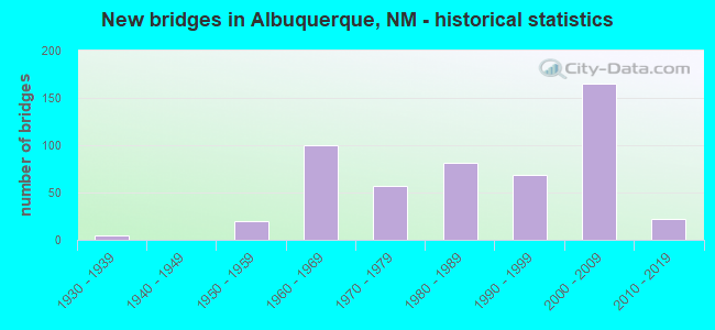
- New bridges - historical statistics
- 51930-1939
- 201950-1959
- 1001960-1969
- 571970-1979
- 811980-1989
- 691990-1999
- 1652000-2009
- 222010-2019

- Reconstructed bridges - Historical Statistics
- 11940-1949
- 01950-1959
- 61960-1969
- 31970-1979
- 151980-1989
- 201990-1999
- 72000-2009
- 42010-2019


- Bridge Condition - Deck
- 47.8%Good
- 41.3%Satisfactory
- 10.9%Fair

- Bridge Condition - Superstructure
- 58.3%Very good
- 27.0%Good
- 13.9%Satisfactory
- 0.9%Fair
- 0.4%Poor

- Bridge Condition - Substructure
- 49.6%Very good
- 33.9%Good
- 13.9%Satisfactory
- 1.3%Fair
- 1.3%Poor
- 0.4%Serious

- Bridge Condition - Channel
- 1.5%Very good
- 61.8%Good
- 31.7%Satisfactory
- 4.5%Fair
- 0.5%Poor

- Bridge Condition - Culverts
- 1.1%Very good
- 16.0%Good
- 52.1%Satisfactory
- 30.9%Fair
Find on map >> Show street view
Structure Number: 1773, Location: Coal Ave Over RR and 1st (Lat: 35.079978, Lng: -106.647347), Route carried "on" structure: City street 4028, Year Built: 1936, Year Reconstructed: 1978, Status: Open, Structure Length: 27.89m (91.50ft), Average Daily Traffic: 4,273 (year 2020), Average Future Daily Traffic: 10,611 (year 2040), Design Load: HS 20, Features Intersected: 1st St & NMRX, Facility Carried by Structure: Coal Avenue
Minimum Vertical Clearance: 30+ m (98+ ft), Kilometerpoint: 0.111, Lanes on structure: 3, Lanes under structure: 2, Base Highway Network: Yes, Owner: City or Municipal Highway Agency, Approaching Roadway Width: 14.0m (45.9ft), Material/Design: Steel continuous, Design/Construction: Stringer/Multi-beam, Number Of Spans In Main Unit: 15, Length of Maximum Span: 24.7m (81.0ft), Curb or Sidewalk Widths: Left: 1.9m (6.2ft), Right: 1.9m (6.2ft), Curb-To-Curb Width: 14.0m (45.9ft), Out-to-Out Width: 16.5m (54.1ft)
Condition: Deck: Satisfactory, Superstructure: Satisfactory, Substructure: Satisfactory, Operating Rating: 71.3 metric tons, Method Used To Determine Operating Rating: Load Factor (LF), Inventory Rating: 32.4 metric tons, Method Used To Determine Inventory Rating: Load Factor (LF), Structural Evaluation: Equal to present minimum criteria, Deck Geometry: Somewhat better than minimum adequacy, Underclear: Meets minimum limits, Approach Roadway Alignment: Equal to present desirable criteria, Length Of Structure Improvement: 27.89m (91.50ft), Designated Inspection Frequency: Every 24 months, Inspection Date: April 2020, Bridge Improvement Cost: $2,421,000, Roadway Improvement Cost: $242,000, Total Project Cost: $3,631,000 ( Estimate for 2020), Deck Structure Type: Concrete Cast-file-Place, Wearing Surface/Protective System: Wearing Surface: Epoxy Overlay
Find on map >> Show street view
Structure Number: 2358, Location: 15.8 MI S OF US-389/CARRI (Lat: 33.479767, Lng: -106.055550), Route carried "on" structure: US 54, Year Built: 1939, Year Reconstructed: 2014, Status: Open, Structure Length: 1.00m (3.28ft), Average Daily Traffic: 1,749 (year 2020), Truck Traffic: 16%, Average Future Daily Traffic: 1,350 (year 2040), Design Load: H 15, Features Intersected: UNNAMED WATERWAY
Minimum Vertical Clearance: 30+ m (98+ ft), Kilometerpoint: 173.254, Lanes on structure: 2, Base Highway Network: Yes, Owner: State Highway Agency, Approaching Roadway Width: 10.7m (35.1ft), Material/Design: Concrete continuous, Design/Construction: Culvert, Number Of Spans In Main Unit: 5, Length of Maximum Span: 1.8m (5.9ft)
Condition: Channel: Satisfactory, Culverts: Satisfactory, Operating Rating: 37.3 metric tons, Method Used To Determine Operating Rating: Load Factor (LF), Inventory Rating: 22.7 metric tons, Method Used To Determine Inventory Rating: Load Factor (LF), Structural Evaluation: Equal to present minimum criteria, Waterway Adequacy: Better than present minimum criteria, Approach Roadway Alignment: Equal to present desirable criteria, Length Of Structure Improvement: 0.94m (3.08ft), Designated Inspection Frequency: Every 48 months, Inspection Date: January 2022, Bridge Improvement Cost: $51,000, Roadway Improvement Cost: $5,000, Total Project Cost: $77,000 ( Estimate for 2020)
Find on map >> Show street view
Structure Number: 5751, Location: 4.1 MI N OF JCT I-40 (Lat: 35.146883, Lng: -106.589711), Route carried "on" structure: Interstate 2523, Year Built: 1955, Status: Open, Structure Length: 4.21m (13.81ft), Average Daily Traffic: 11,551 (year 2018), Truck Traffic: 2%, Average Future Daily Traffic: 15,254 (year 2038), Design Load: HS 20, Features Intersected: BEAR CANYON ARROYO
Minimum Vertical Clearance: 30+ m (98+ ft), Kilometerpoint: 372.206, Lanes on structure: 14, Base Highway Network: Yes, Owner: State Highway Agency, Approaching Roadway Width: 37.8m (124.0ft), Material/Design: Concrete continuous, Design/Construction: Culvert, Number Of Spans In Main Unit: 13, Length of Maximum Span: 3.0m (9.8ft)
Condition: Channel: Satisfactory, Culverts: Satisfactory, Operating Rating: 45.4 metric tons, Method Used To Determine Operating Rating: Load Factor (LF), Inventory Rating: 32.4 metric tons, Method Used To Determine Inventory Rating: Load Factor (LF), Structural Evaluation: Equal to present minimum criteria, Waterway Adequacy: Better than present minimum criteria, Approach Roadway Alignment: Equal to present desirable criteria, Designated Inspection Frequency: Every 24 months, Inspection Date: January 2022
Find on map >> Show street view
Structure Number: 5752, Location: 0.50 MI S PASEO DEL NORTE (Lat: 35.165292, Lng: -106.585764), Route carried "on" structure: Interstate 25, Year Built: 1955, Year Reconstructed: 1985, Status: Open, Structure Length: 1.34m (4.40ft), Average Daily Traffic: 126,529 (year 2020), Truck Traffic: 13%, Average Future Daily Traffic: 233,170 (year 2040), Design Load: HS 20, Features Intersected: NORTH PINO ARROYO
Minimum Vertical Clearance: 30+ m (98+ ft), Kilometerpoint: 372.273, Lanes on structure: 14, Base Highway Network: Yes, Owner: State Highway Agency, Approaching Roadway Width: 37.8m (124.0ft), Skew: 20 degrees, Material/Design: Concrete continuous, Design/Construction: Culvert, Number Of Spans In Main Unit: 4, Length of Maximum Span: 3.0m (9.8ft)
Condition: Channel: Good, Culverts: Fair, Operating Rating: 53.5 metric tons, Method Used To Determine Operating Rating: Load Factor (LF), Inventory Rating: 32.4 metric tons, Method Used To Determine Inventory Rating: Load Factor (LF), Structural Evaluation: Somewhat better than minimum adequacy, Waterway Adequacy: Equal to present desirable criteria, Approach Roadway Alignment: Equal to present desirable criteria, Designated Inspection Frequency: Every 24 months, Inspection Date: October 2021
Find on map >> Show street view
Structure Number: 5754, Location: 0.3 MI N /PASEO DEL NORTE (Lat: 35.180158, Lng: -106.582128), Route carried "on" structure: Interstate 2523, Year Built: 1955, Year Reconstructed: 1985, Status: Open, Structure Length: 1.19m (3.90ft), Average Daily Traffic: 12,354 (year 2018), Truck Traffic: 2%, Average Future Daily Traffic: 16,314 (year 2038), Design Load: HS 20, Features Intersected: UNNAMED WATERWAY
Minimum Vertical Clearance: 30+ m (98+ ft), Kilometerpoint: 373.786, Lanes on structure: 10, Base Highway Network: Yes, Owner: State Highway Agency, Approaching Roadway Width: 30.5m (100.1ft), Material/Design: Concrete continuous, Design/Construction: Culvert, Number Of Spans In Main Unit: 4, Length of Maximum Span: 2.7m (8.9ft)
Condition: Channel: Fair, Culverts: Fair, Operating Rating: 48.6 metric tons, Method Used To Determine Operating Rating: Load Factor (LF), Inventory Rating: 32.4 metric tons, Method Used To Determine Inventory Rating: Load Factor (LF), Structural Evaluation: Somewhat better than minimum adequacy, Waterway Adequacy: Better than present minimum criteria, Approach Roadway Alignment: Equal to present desirable criteria, Length Of Structure Improvement: 1.19m (3.90ft), Designated Inspection Frequency: Every 24 months, Inspection Date: December 2021, Bridge Improvement Cost: $549,000, Roadway Improvement Cost: $54,000, Total Project Cost: $824,000 ( Estimate for 2030)
Find on map >> Show street view
Structure Number: 5989, Location: 0.5 Mi S of Jct I-25/I-40 (Lat: 35.093556, Lng: -106.633569), Route carried "on" structure: Interstate 25, Year Built: 1959, Year Reconstructed: 2002, Status: Open, Structure Length: 5.18m (16.99ft), Average Daily Traffic: 173,343 (year 2020), Truck Traffic: 13%, Average Future Daily Traffic: 319,440 (year 2040), Design Load: HS 20, Features Intersected: Mountain Road
Minimum Vertical Clearance: 30+ m (98+ ft), Kilometerpoint: 362.698, Lanes on structure: 5, Lanes under structure: 4, Base Highway Network: Yes, Owner: State Highway Agency, Approaching Roadway Width: 24.7m (81.0ft), Skew: 30 degrees, Material/Design: Prestressed concrete continuous, Design/Construction: Stringer/Multi-beam, Number Of Spans In Main Unit: 3, Length of Maximum Span: 22.9m (75.1ft), Curb-To-Curb Width: 24.7m (81.0ft), Out-to-Out Width: 25.0m (82.0ft)
Condition: Deck: Satisfactory, Superstructure: Fair, Substructure: Good, Operating Rating: 33.6 metric tons, Method Used To Determine Operating Rating: Load Factor (LF), Inventory Rating: 18.8 metric tons, Method Used To Determine Inventory Rating: Load Factor (LF), Structural Evaluation: Meets minimum limits, Deck Geometry: Better than present minimum criteria, Underclear: Equal to present minimum criteria, Approach Roadway Alignment: Equal to present desirable criteria, Length Of Structure Improvement: 5.12m (16.80ft), Designated Inspection Frequency: Every 24 months, Inspection Date: September 2020, Bridge Improvement Cost: $580,000, Roadway Improvement Cost: $68,000, Total Project Cost: $880,000 ( Estimate for 2020), Deck Structure Type: Concrete Cast-file-Place, Wearing Surface/Protective System: Wearing Surface: Epoxy Overlay, Deck Protection: Epoxy Coated Reinforcing
Find on map >> Show street view
Structure Number: 599, Location: 0.5 Mi S of Jct I-25/I-40 (Lat: 35.093661, Lng: -106.633842), Route carried "on" structure: Interstate 25, Year Built: 1959, Year Reconstructed: 2002, Status: Open, Structure Length: 5.18m (16.99ft), Average Daily Traffic: 173,343 (year 2020), Truck Traffic: 13%, Average Future Daily Traffic: 319,440 (year 2040), Design Load: HS 20, Features Intersected: Mountain Road
Minimum Vertical Clearance: 30+ m (98+ ft), Kilometerpoint: 362.698, Lanes on structure: 6, Lanes under structure: 4, Base Highway Network: Yes, Owner: State Highway Agency, Approaching Roadway Width: 28.2m (92.5ft), Skew: 30 degrees, Material/Design: Prestressed concrete, Design/Construction: Stringer/Multi-beam, Number Of Spans In Main Unit: 3, Length of Maximum Span: 22.9m (75.1ft), Curb-To-Curb Width: 28.2m (92.5ft), Out-to-Out Width: 29.0m (95.1ft)
Condition: Deck: Satisfactory, Superstructure: Fair, Substructure: Good, Operating Rating: 47.5 metric tons, Method Used To Determine Operating Rating: Load Factor (LF), Inventory Rating: 28.1 metric tons, Method Used To Determine Inventory Rating: Load Factor (LF), Structural Evaluation: Somewhat better than minimum adequacy, Deck Geometry: Equal to present minimum criteria, Underclear: Better than present minimum criteria, Approach Roadway Alignment: Equal to present desirable criteria, Designated Inspection Frequency: Every 24 months, Inspection Date: September 2020, Deck Structure Type: Concrete Cast-file-Place, Wearing Surface/Protective System: Wearing Surface: Epoxy Overlay, Deck Protection: Epoxy Coated Reinforcing
Find on map >> Show street view
Structure Number: 6065, Location: 1.15 MI N OF CANDELARIA (Lat: 35.147258, Lng: -106.586342), Route carried "on" structure: City street 25, Year Built: 1958, Year Reconstructed: 1982, Status: Open, Structure Length: 1.34m (4.40ft), Average Daily Traffic: 30,490 (year 2020), Truck Traffic: 7%, Average Future Daily Traffic: 42,907 (year 2040), Design Load: HS 20, Features Intersected: BEAR CANYON ARROYO
Minimum Vertical Clearance: 30+ m (98+ ft), Kilometerpoint: 10.316, Lanes on structure: 20, Base Highway Network: Yes, Owner: City or Municipal Highway Agency, Approaching Roadway Width: 25.6m (84.0ft), Skew: 30 degrees, Material/Design: Concrete continuous, Design/Construction: Culvert, Number Of Spans In Main Unit: 4, Length of Maximum Span: 3.0m (9.8ft)
Condition: Channel: Satisfactory, Culverts: Satisfactory, Operating Rating: 40.5 metric tons, Method Used To Determine Operating Rating: Load Factor (LF), Inventory Rating: 32.4 metric tons, Method Used To Determine Inventory Rating: Load Factor (LF), Structural Evaluation: Equal to present minimum criteria, Waterway Adequacy: Superior to present desirable criteria, Approach Roadway Alignment: Equal to present desirable criteria, Designated Inspection Frequency: Every 24 months, Inspection Date: April 2021
Find on map >> Show street view
Structure Number: 6102, Location: 8.1 Mi E of Jct I-25/I-40 (Lat: 35.069581, Lng: -106.496828), Route carried "on" structure: Interstate 40, Year Built: 1959, Year Reconstructed: 1999, Status: Open, Structure Length: 7.13m (23.39ft), Average Daily Traffic: 57,978 (year 2020), Truck Traffic: 13%, Average Future Daily Traffic: 106,842 (year 2040), Design Load: HS 20, Features Intersected: NM-556/Tramway Blvd
Minimum Vertical Clearance: 30+ m (98+ ft), Kilometerpoint: 269.565, Lanes on structure: 3, Lanes under structure: 6, Base Highway Network: Yes, Owner: State Highway Agency, Approaching Roadway Width: 18.1m (59.4ft), Skew: 30 degrees, Material/Design: Prestressed concrete, Design/Construction: Stringer/Multi-beam, Number Of Spans In Main Unit: 4, Length of Maximum Span: 19.2m (63.0ft), Curb-To-Curb Width: 18.0m (59.1ft), Out-to-Out Width: 20.1m (65.9ft)
Condition: Deck: Good, Superstructure: Good, Substructure: Good, Operating Rating: 53.9 metric tons, Method Used To Determine Operating Rating: Load Factor (LF), Inventory Rating: 32.7 metric tons, Method Used To Determine Inventory Rating: Load Factor (LF), Structural Evaluation: Better than present minimum criteria, Deck Geometry: Better than present minimum criteria, Underclear: Meets minimum limits, Approach Roadway Alignment: Equal to present desirable criteria, Length Of Structure Improvement: 7.04m (23.10ft), Designated Inspection Frequency: Every 24 months, Inspection Date: June 2021, Bridge Improvement Cost: $750,000, Roadway Improvement Cost: $80,000, Total Project Cost: $1,130,000, Deck Structure Type: Concrete Cast-file-Place, Wearing Surface/Protective System: Wearing Surface: Latex Concrete, Deck Protection: Epoxy Coated Reinforcing
Find on map >> Show street view
Structure Number: 6103, Location: 8.1 M E Jct I-40/I-25 (Lat: 35.069469, Lng: -106.496914), Route carried "on" structure: Interstate 40, Year Built: 1959, Year Reconstructed: 1999, Status: Open, Structure Length: 7.13m (23.39ft), Average Daily Traffic: 57,978 (year 2020), Truck Traffic: 13%, Average Future Daily Traffic: 106,842 (year 2040), Design Load: HS 20, Features Intersected: NM-556/Tramway Blvd
Minimum Vertical Clearance: 30+ m (98+ ft), Kilometerpoint: 269.565, Lanes on structure: 3, Lanes under structure: 7, Base Highway Network: Yes, Owner: State Highway Agency, Approaching Roadway Width: 18.0m (59.1ft), Skew: 30 degrees, Material/Design: Prestressed concrete, Design/Construction: Stringer/Multi-beam, Number Of Spans In Main Unit: 4, Length of Maximum Span: 19.2m (63.0ft), Curb-To-Curb Width: 18.1m (59.4ft), Out-to-Out Width: 18.4m (60.4ft)
Condition: Deck: Good, Superstructure: Fair, Substructure: Good, Operating Rating: 53.9 metric tons, Method Used To Determine Operating Rating: Load Factor (LF), Inventory Rating: 27.8 metric tons, Method Used To Determine Inventory Rating: Load Factor (LF), Structural Evaluation: Somewhat better than minimum adequacy, Deck Geometry: Better than present minimum criteria, Underclear: Meets minimum limits, Approach Roadway Alignment: Equal to present desirable criteria, Length Of Structure Improvement: 7.04m (23.10ft), Designated Inspection Frequency: Every 24 months, Inspection Date: June 2021, Bridge Improvement Cost: $790,000, Roadway Improvement Cost: $84,000, Total Project Cost: $1,190,000, Deck Structure Type: Concrete Cast-file-Place, Wearing Surface/Protective System: Wearing Surface: Latex Concrete, Deck Protection: Epoxy Coated Reinforcing
Find on map >> Show street view
Structure Number: 6104, Location: 8.3 M E Jct 1-40/I-25 (Lat: 35.068347, Lng: -106.493617), Route carried "on" structure: Interstate 40, Year Built: 1959, Year Reconstructed: 1999, Status: Open, Structure Length: 6.80m (22.31ft), Average Daily Traffic: 57,978 (year 2020), Truck Traffic: 13%, Average Future Daily Traffic: 106,842 (year 2040), Design Load: HS 20, Features Intersected: Central Ave.
Minimum Vertical Clearance: 30+ m (98+ ft), Kilometerpoint: 269.871, Lanes on structure: 3, Lanes under structure: 6, Base Highway Network: Yes, Owner: State Highway Agency, Approaching Roadway Width: 18.0m (59.1ft), Skew: 24 degrees, Material/Design: Prestressed concrete, Design/Construction: Stringer/Multi-beam, Number Of Spans In Main Unit: 3, Length of Maximum Span: 26.8m (87.9ft), Curb-To-Curb Width: 17.6m (57.7ft), Out-to-Out Width: 19.0m (62.3ft)
Condition: Deck: Good, Superstructure: Good, Substructure: Good, Operating Rating: 54.8 metric tons, Method Used To Determine Operating Rating: Load Factor (LF), Inventory Rating: 34.4 metric tons, Method Used To Determine Inventory Rating: Load Factor (LF), Structural Evaluation: Better than present minimum criteria, Deck Geometry: Better than present minimum criteria, Underclear: Equal to present minimum criteria, Approach Roadway Alignment: Equal to present desirable criteria, Length Of Structure Improvement: 6.77m (22.21ft), Designated Inspection Frequency: Every 24 months, Inspection Date: June 2021, Bridge Improvement Cost: $730,000, Roadway Improvement Cost: $88,000, Total Project Cost: $1,110,000 ( Estimate for 2030), Deck Structure Type: Concrete Cast-file-Place, Wearing Surface/Protective System: Wearing Surface: Latex Concrete, Deck Protection: Epoxy Coated Reinforcing
Find on map >> Show street view
Structure Number: 6105, Location: 8.3 Mi E of Jct I-25/I-40 (Lat: 35.068286, Lng: -106.493831), Route carried "on" structure: Interstate 40, Year Built: 1959, Year Reconstructed: 1999, Status: Open, Structure Length: 6.80m (22.31ft), Average Daily Traffic: 57,978 (year 2020), Truck Traffic: 13%, Average Future Daily Traffic: 106,842 (year 2040), Design Load: HS 20, Features Intersected: Central Avenue
Minimum Vertical Clearance: 30+ m (98+ ft), Kilometerpoint: 269.871, Lanes on structure: 3, Lanes under structure: 6, Base Highway Network: Yes, Owner: State Highway Agency, Approaching Roadway Width: 18.0m (59.1ft), Skew: 24 degrees, Material/Design: Prestressed concrete, Design/Construction: Stringer/Multi-beam, Number Of Spans In Main Unit: 3, Length of Maximum Span: 26.8m (87.9ft), Curb-To-Curb Width: 17.9m (58.7ft), Out-to-Out Width: 18.4m (60.4ft)
Condition: Deck: Good, Superstructure: Satisfactory, Substructure: Good, Operating Rating: 55.2 metric tons, Method Used To Determine Operating Rating: Load Factor (LF), Inventory Rating: 29.4 metric tons, Method Used To Determine Inventory Rating: Load Factor (LF), Structural Evaluation: Equal to present minimum criteria, Deck Geometry: Better than present minimum criteria, Underclear: Equal to present minimum criteria, Approach Roadway Alignment: Equal to present desirable criteria, Length Of Structure Improvement: 6.77m (22.21ft), Designated Inspection Frequency: Every 24 months, Inspection Date: June 2021, Bridge Improvement Cost: $730,000, Roadway Improvement Cost: $88,000, Total Project Cost: $1,110,000 ( Estimate for 2030), Deck Structure Type: Concrete Cast-file-Place, Wearing Surface/Protective System: Wearing Surface: Latex Concrete, Deck Protection: Epoxy Coated Reinforcing
Find on map >> Show street view
Structure Number: 6147, Location: Jct I-25/I-40 (Lat: 35.085256, Lng: -106.636053), Route carried "on" structure: Interstate 25, Year Built: 1961, Year Reconstructed: 2002, Status: Open, Structure Length: 5.79m (19.00ft), Average Daily Traffic: 173,343 (year 2020), Truck Traffic: 13%, Average Future Daily Traffic: 319,440 (year 2040), Design Load: HS 20, Features Intersected: Dr Martin L King Jr Dr
Minimum Vertical Clearance: 30+ m (98+ ft), Kilometerpoint: 361.732, Lanes on structure: 3, Lanes under structure: 6, Base Highway Network: Yes, Owner: State Highway Agency, Approaching Roadway Width: 19.0m (62.3ft), Skew: 30 degrees, Material/Design: Prestressed concrete, Design/Construction: Stringer/Multi-beam, Number Of Spans In Main Unit: 3, Length of Maximum Span: 28.0m (91.9ft), Curb-To-Curb Width: 21.1m (69.2ft), Out-to-Out Width: 21.9m (71.9ft)
Condition: Deck: Good, Superstructure: Good, Substructure: Good, Operating Rating: 60.1 metric tons, Method Used To Determine Operating Rating: Load Factor (LF), Inventory Rating: 31.3 metric tons, Method Used To Determine Inventory Rating: Load Factor (LF), Structural Evaluation: Better than present minimum criteria, Deck Geometry: Superior to present desirable criteria, Underclear: Equal to present minimum criteria, Approach Roadway Alignment: Equal to present minimum criteria, Length Of Structure Improvement: 5.79m (19.00ft), Designated Inspection Frequency: Every 24 months, Inspection Date: January 2021, Bridge Improvement Cost: $515,000, Roadway Improvement Cost: $51,000, Total Project Cost: $772,000 ( Estimate for 2030), Deck Structure Type: Concrete Cast-file-Place, Wearing Surface/Protective System: Wearing Surface: Epoxy Overlay, Deck Protection: Epoxy Coated Reinforcing
Find on map >> Show street view
Structure Number: 6148, Location: Jct of I-25/I-40 (Lat: 35.085297, Lng: -106.636253), Route carried "on" structure: Interstate 25, Year Built: 1961, Year Reconstructed: 2002, Status: Open, Structure Length: 5.70m (18.70ft), Average Daily Traffic: 173,343 (year 2020), Truck Traffic: 13%, Average Future Daily Traffic: 319,440 (year 2040), Design Load: HS 20, Features Intersected: Dr Martin L. King Ave.
Minimum Vertical Clearance: 30+ m (98+ ft), Kilometerpoint: 361.732, Lanes on structure: 8, Lanes under structure: 6, Base Highway Network: Yes, Owner: State Highway Agency, Approaching Roadway Width: 19.0m (62.3ft), Skew: 30 degrees, Material/Design: Prestressed concrete, Design/Construction: Stringer/Multi-beam, Number Of Spans In Main Unit: 3, Length of Maximum Span: 28.3m (92.8ft), Curb-To-Curb Width: 21.1m (69.2ft), Out-to-Out Width: 21.9m (71.9ft)
Condition: Deck: Good, Superstructure: Good, Substructure: Good, Operating Rating: 60.1 metric tons, Method Used To Determine Operating Rating: Load Factor (LF), Inventory Rating: 31.3 metric tons, Method Used To Determine Inventory Rating: Load Factor (LF), Structural Evaluation: Better than present minimum criteria, Deck Geometry: High priority of replacement, Underclear: Better than present minimum criteria, Approach Roadway Alignment: Better than present minimum criteria, Length Of Structure Improvement: 5.79m (19.00ft), Designated Inspection Frequency: Every 24 months, Inspection Date: January 2021, Bridge Improvement Cost: $529,000, Roadway Improvement Cost: $53,000, Total Project Cost: $794,000 ( Estimate for 2030), Deck Structure Type: Concrete Cast-file-Place, Wearing Surface/Protective System: Deck Protection: Epoxy Coated Reinforcing
Find on map >> Show street view
Structure Number: 6149, Location: I-25 over Central Avenue (Lat: 35.082681, Lng: -106.636556), Route carried "on" structure: Interstate 25, Year Built: 1961, Year Reconstructed: 1967, Status: Open, Structure Length: 6.16m (20.21ft), Average Daily Traffic: 159,728 (year 2020), Truck Traffic: 13%, Average Future Daily Traffic: 294,350 (year 2040), Design Load: HS 20, Features Intersected: Central Avenue-FL4016
Minimum Vertical Clearance: 30+ m (98+ ft), Kilometerpoint: 361.459, Lanes on structure: 4, Lanes under structure: 4, Base Highway Network: Yes, Owner: State Highway Agency, Approaching Roadway Width: 16.8m (55.1ft), Skew: 30 degrees, Material/Design: Prestressed concrete, Design/Construction: Stringer/Multi-beam, Number Of Spans In Main Unit: 3, Length of Maximum Span: 31.4m (103.0ft), Curb-To-Curb Width: 16.9m (55.4ft), Out-to-Out Width: 18.3m (60.0ft)
Condition: Deck: Satisfactory, Superstructure: Satisfactory, Substructure: Fair, Operating Rating: 62.1 metric tons, Method Used To Determine Operating Rating: Load Factor (LF), Inventory Rating: 29.2 metric tons, Method Used To Determine Inventory Rating: Load Factor (LF), Structural Evaluation: Somewhat better than minimum adequacy, Deck Geometry: Meets minimum limits, Underclear: High priority of replacement, Approach Roadway Alignment: Equal to present desirable criteria, Length Of Structure Improvement: 6.16m (20.21ft), Designated Inspection Frequency: Every 24 months, Inspection Date: April 2021, Bridge Improvement Cost: $604,000, Roadway Improvement Cost: $60,000, Total Project Cost: $906,000 ( Estimate for 2030), Deck Structure Type: Concrete Cast-file-Place, Wearing Surface/Protective System: Wearing Surface: Epoxy Overlay
Find on map >> Show street view
Structure Number: 615, Location: I-25 Over Central Avenue (Lat: 35.082700, Lng: -106.636714), Route carried "on" structure: Interstate 25, Year Built: 1961, Year Reconstructed: 1988, Status: Open, Structure Length: 6.16m (20.21ft), Average Daily Traffic: 159,728 (year 2020), Truck Traffic: 13%, Average Future Daily Traffic: 294,350 (year 2040), Design Load: HS 20, Features Intersected: Central Avenue-FL4016
Minimum Vertical Clearance: 30+ m (98+ ft), Kilometerpoint: 361.459, Lanes on structure: 4, Lanes under structure: 7, Base Highway Network: Yes, Owner: State Highway Agency, Approaching Roadway Width: 22.6m (74.1ft), Skew: 30 degrees, Material/Design: Prestressed concrete, Design/Construction: Stringer/Multi-beam, Number Of Spans In Main Unit: 3, Length of Maximum Span: 31.4m (103.0ft), Curb-To-Curb Width: 26.2m (86.0ft), Out-to-Out Width: 26.2m (86.0ft)
Condition: Deck: Satisfactory, Superstructure: Fair, Substructure: Satisfactory, Operating Rating: 61.4 metric tons, Method Used To Determine Operating Rating: Load Factor (LF), Inventory Rating: 20.9 metric tons, Method Used To Determine Inventory Rating: Load Factor (LF), Structural Evaluation: Somewhat better than minimum adequacy, Deck Geometry: Superior to present desirable criteria, Underclear: High priority of replacement, Approach Roadway Alignment: Equal to present desirable criteria, Length Of Structure Improvement: 6.16m (20.21ft), Designated Inspection Frequency: Every 24 months, Inspection Date: April 2021, Bridge Improvement Cost: $2,000, Roadway Improvement Cost: $10,000, Total Project Cost: $30,000, Deck Structure Type: Concrete Cast-file-Place
Find on map >> Show street view
Structure Number: 6178, Location: 0.3 MI E Bio Park (Lat: 35.093353, Lng: -106.677936), Route carried "on" structure: City street 4016, Year Built: 1935, Year Reconstructed: 1954, Status: Open, Structure Length: 0.79m (2.59ft), Average Daily Traffic: 22,727 (year 2020), Truck Traffic: 7%, Average Future Daily Traffic: 31,983 (year 2040), Design Load: H 15, Features Intersected: Alameda Drain, Facility Carried by Structure: Central Avenue
Minimum Vertical Clearance: 30+ m (98+ ft), Kilometerpoint: 11.431, Lanes on structure: 6, Base Highway Network: Yes, Owner: City or Municipal Highway Agency, Approaching Roadway Width: 19.5m (64.0ft), Skew: 24 degrees, Material/Design: Concrete continuous, Design/Construction: Culvert, Number Of Spans In Main Unit: 2, Length of Maximum Span: 2.4m (7.9ft)
Condition: Channel: Satisfactory, Culverts: Satisfactory, Operating Rating: 89.8 metric tons, Method Used To Determine Operating Rating: Load Factor (LF), Inventory Rating: 44.1 metric tons, Method Used To Determine Inventory Rating: Load Factor (LF), Structural Evaluation: Equal to present minimum criteria, Waterway Adequacy: Equal to present desirable criteria, Approach Roadway Alignment: Equal to present desirable criteria, Designated Inspection Frequency: Every 24 months, Inspection Date: January 2022
Find on map >> Show street view
Structure Number: 6201, Location: 1.4 M S Jct I-25/I-40 (Lat: 35.079708, Lng: -106.637131), Route carried "on" structure: Interstate 25, Year Built: 1961, Year Reconstructed: 1967, Status: Open, Structure Length: 4.63m (15.19ft), Average Daily Traffic: 141,660 (year 2020), Truck Traffic: 13%, Average Future Daily Traffic: 261,054 (year 2040), Design Load: HS 20, Features Intersected: Lead Avenue
Minimum Vertical Clearance: 30+ m (98+ ft), Kilometerpoint: 361.105, Lanes on structure: 3, Lanes under structure: 3, Base Highway Network: Yes, Owner: State Highway Agency, Approaching Roadway Width: 15.5m (50.9ft), Material/Design: Prestressed concrete, Design/Construction: Stringer/Multi-beam, Number Of Spans In Main Unit: 3, Length of Maximum Span: 19.1m (62.7ft), Curb-To-Curb Width: 15.5m (50.9ft), Out-to-Out Width: 16.5m (54.1ft)
Condition: Deck: Satisfactory, Superstructure: Good, Substructure: Fair, Operating Rating: 53.9 metric tons, Method Used To Determine Operating Rating: Load Factor (LF), Inventory Rating: 32.7 metric tons, Method Used To Determine Inventory Rating: Load Factor (LF), Structural Evaluation: Somewhat better than minimum adequacy, Deck Geometry: Somewhat better than minimum adequacy, Underclear: Equal to present minimum criteria, Approach Roadway Alignment: Equal to present desirable criteria, Length Of Structure Improvement: 4.63m (15.19ft), Designated Inspection Frequency: Every 24 months, Inspection Date: December 2020, Bridge Improvement Cost: $412,000, Roadway Improvement Cost: $41,000, Total Project Cost: $618,000 ( Estimate for 2020), Deck Structure Type: Concrete Cast-file-Place, Wearing Surface/Protective System: Wearing Surface: Epoxy Overlay
Find on map >> Show street view
Structure Number: 6202, Location: 1.4 M S Jct I-40/I-25 (Lat: 35.079733, Lng: -106.637286), Route carried "on" structure: Interstate 25, Year Built: 1961, Year Reconstructed: 1988, Status: Open, Structure Length: 4.63m (15.19ft), Average Daily Traffic: 141,660 (year 2020), Truck Traffic: 13%, Average Future Daily Traffic: 261,054 (year 2040), Design Load: HS 20, Features Intersected: Lead Avenue
Minimum Vertical Clearance: 30+ m (98+ ft), Kilometerpoint: 361.105, Lanes on structure: 4, Lanes under structure: 4, Base Highway Network: Yes, Owner: State Highway Agency, Approaching Roadway Width: 21.8m (71.5ft), Skew: 30 degrees, Material/Design: Prestressed concrete, Design/Construction: Stringer/Multi-beam, Number Of Spans In Main Unit: 3, Length of Maximum Span: 19.2m (63.0ft), Curb-To-Curb Width: 21.3m (69.9ft), Out-to-Out Width: 28.7m (94.2ft)
Condition: Deck: Fair, Superstructure: Good, Substructure: Fair, Operating Rating: 53.9 metric tons, Method Used To Determine Operating Rating: Load Factor (LF), Inventory Rating: 32.7 metric tons, Method Used To Determine Inventory Rating: Load Factor (LF), Structural Evaluation: Somewhat better than minimum adequacy, Deck Geometry: Better than present minimum criteria, Underclear: Meets minimum limits, Approach Roadway Alignment: Equal to present desirable criteria, Length Of Structure Improvement: 4.63m (15.19ft), Designated Inspection Frequency: Every 24 months, Inspection Date: December 2020, Bridge Improvement Cost: $718,000, Roadway Improvement Cost: $71,000, Total Project Cost: $1,077,000 ( Estimate for 2020), Deck Structure Type: Concrete Cast-file-Place, Wearing Surface/Protective System: Wearing Surface: Epoxy Overlay, Deck Protection: Epoxy Coated Reinforcing
Find on map >> Show street view
Structure Number: 6203, Location: 1.5 MI S of Jct I-25/I-40 (Lat: 35.078739, Lng: -106.637325), Route carried "on" structure: Interstate 25, Year Built: 1961, Year Reconstructed: 1967, Status: Open, Structure Length: 4.54m (14.90ft), Average Daily Traffic: 141,660 (year 2020), Truck Traffic: 13%, Average Future Daily Traffic: 261,054 (year 2040), Design Load: HS 20, Features Intersected: Coal Avenue
Minimum Vertical Clearance: 30+ m (98+ ft), Kilometerpoint: 361.008, Lanes on structure: 3, Lanes under structure: 3, Base Highway Network: Yes, Owner: State Highway Agency, Approaching Roadway Width: 16.0m (52.5ft), Skew: 30 degrees, Material/Design: Prestressed concrete, Design/Construction: Stringer/Multi-beam, Number Of Spans In Main Unit: 3, Length of Maximum Span: 18.9m (62.0ft), Curb-To-Curb Width: 15.6m (51.2ft), Out-to-Out Width: 16.5m (54.1ft)
Condition: Deck: Satisfactory, Superstructure: Fair, Substructure: Fair, Operating Rating: 53.9 metric tons, Method Used To Determine Operating Rating: Load Factor (LF), Inventory Rating: 32.7 metric tons, Method Used To Determine Inventory Rating: Load Factor (LF), Structural Evaluation: Somewhat better than minimum adequacy, Deck Geometry: Somewhat better than minimum adequacy, Underclear: Equal to present minimum criteria, Approach Roadway Alignment: Equal to present desirable criteria, Length Of Structure Improvement: 4.60m (15.09ft), Designated Inspection Frequency: Every 24 months, Inspection Date: December 2020, Bridge Improvement Cost: $408,000, Roadway Improvement Cost: $40,000, Total Project Cost: $612,000 ( Estimate for 2020), Deck Structure Type: Concrete Cast-file-Place
Find on map >> Show street view
Structure Number: 6204, Location: Jct of I-25/Coal Avenue (Lat: 35.078758, Lng: -106.637486), Route carried "on" structure: Interstate 25, Year Built: 1961, Year Reconstructed: 1988, Status: Open, Structure Length: 4.59m (15.06ft), Average Daily Traffic: 141,660 (year 2020), Truck Traffic: 13%, Average Future Daily Traffic: 261,054 (year 2040), Design Load: HS 20, Features Intersected: Coal Avenue
Minimum Vertical Clearance: 30+ m (98+ ft), Kilometerpoint: 361.008, Lanes on structure: 3, Lanes under structure: 3, Base Highway Network: Yes, Owner: State Highway Agency, Approaching Roadway Width: 19.2m (63.0ft), Skew: 30 degrees, Material/Design: Prestressed concrete, Design/Construction: Stringer/Multi-beam, Number Of Spans In Main Unit: 3, Length of Maximum Span: 18.9m (62.0ft), Curb-To-Curb Width: 19.2m (63.0ft), Out-to-Out Width: 20.4m (66.9ft)
Condition: Deck: Satisfactory, Superstructure: Satisfactory, Substructure: Fair, Operating Rating: 53.9 metric tons, Method Used To Determine Operating Rating: Load Factor (LF), Inventory Rating: 32.7 metric tons, Method Used To Determine Inventory Rating: Load Factor (LF), Structural Evaluation: Somewhat better than minimum adequacy, Deck Geometry: Superior to present desirable criteria, Underclear: Equal to present minimum criteria, Approach Roadway Alignment: Equal to present desirable criteria, Designated Inspection Frequency: Every 24 months, Inspection Date: December 2020, Deck Structure Type: Concrete Cast-file-Place, Wearing Surface/Protective System: Wearing Surface: Latex Concrete, Deck Protection: Epoxy Coated Reinforcing
Find on map >> Show street view
Structure Number: 6228, Location: 3.2 M N Jct I-25/NM-500 (Lat: 35.069811, Lng: -106.639461), Route carried "on" structure: Interstate 25, Year Built: 1961, Year Reconstructed: 1967, Status: Open, Structure Length: 5.64m (18.50ft), Average Daily Traffic: 126,999 (year 2020), Truck Traffic: 13%, Average Future Daily Traffic: 234,036 (year 2040), Design Load: HS 20, Features Intersected: Avenida Cesar Chavez
Minimum Vertical Clearance: 30+ m (98+ ft), Kilometerpoint: 359.946, Lanes on structure: 3, Lanes under structure: 5, Base Highway Network: Yes, Owner: State Highway Agency, Approaching Roadway Width: 15.9m (52.2ft), Skew: 30 degrees, Material/Design: Prestressed concrete, Design/Construction: Stringer/Multi-beam, Number Of Spans In Main Unit: 3, Length of Maximum Span: 27.4m (89.9ft), Curb-To-Curb Width: 15.8m (51.8ft), Out-to-Out Width: 16.5m (54.1ft)
Condition: Deck: Satisfactory, Superstructure: Fair, Substructure: Fair, Operating Rating: 53.5 metric tons, Method Used To Determine Operating Rating: Load Factor (LF), Inventory Rating: 32.4 metric tons, Method Used To Determine Inventory Rating: Load Factor (LF), Structural Evaluation: Somewhat better than minimum adequacy, Deck Geometry: Somewhat better than minimum adequacy, Underclear: Meets minimum limits, Approach Roadway Alignment: Equal to present desirable criteria, Length Of Structure Improvement: 5.64m (18.50ft), Designated Inspection Frequency: Every 24 months, Inspection Date: November 2020, Bridge Improvement Cost: $501,000, Roadway Improvement Cost: $50,000, Total Project Cost: $752,000 ( Estimate for 2030), Deck Structure Type: Concrete Cast-file-Place, Wearing Surface/Protective System: Wearing Surface: Low Slump Concrete
Find on map >> Show street view
Structure Number: 6229, Location: 3.2 M N Jct I-25/NM-500 (Lat: 35.069806, Lng: -106.639619), Route carried "on" structure: Interstate 25, Year Built: 1961, Year Reconstructed: 1967, Status: Open, Structure Length: 5.61m (18.41ft), Average Daily Traffic: 126,999 (year 2020), Truck Traffic: 13%, Average Future Daily Traffic: 234,036 (year 2040), Design Load: HS 20, Features Intersected: Avenida Cesar Chavez
Minimum Vertical Clearance: 30+ m (98+ ft), Kilometerpoint: 359.946, Lanes on structure: 3, Lanes under structure: 4, Base Highway Network: Yes, Owner: State Highway Agency, Approaching Roadway Width: 15.6m (51.2ft), Skew: 30 degrees, Material/Design: Prestressed concrete, Design/Construction: Stringer/Multi-beam, Number Of Spans In Main Unit: 3, Length of Maximum Span: 27.4m (89.9ft), Curb-To-Curb Width: 15.6m (51.2ft), Out-to-Out Width: 17.1m (56.1ft)
Condition: Deck: Satisfactory, Superstructure: Fair, Substructure: Fair, Operating Rating: 53.5 metric tons, Method Used To Determine Operating Rating: Load Factor (LF), Inventory Rating: 32.4 metric tons, Method Used To Determine Inventory Rating: Load Factor (LF), Structural Evaluation: Somewhat better than minimum adequacy, Deck Geometry: Somewhat better than minimum adequacy, Underclear: Somewhat better than minimum adequacy, Approach Roadway Alignment: Equal to present minimum criteria, Length Of Structure Improvement: 5.61m (18.41ft), Designated Inspection Frequency: Every 24 months, Inspection Date: November 2020, Bridge Improvement Cost: $512,000, Roadway Improvement Cost: $51,000, Total Project Cost: $768,000 ( Estimate for 2030), Deck Structure Type: Concrete Cast-file-Place, Wearing Surface/Protective System: Wearing Surface: Low Slump Concrete
Find on map >> Show street view
Structure Number: 623, Location: 2.5 M N Jct I-25/NM-500 (Lat: 35.059625, Lng: -106.638150), Route carried "on" structure: Interstate 25, Year Built: 1961, Status: Open, Structure Length: 5.94m (19.49ft), Average Daily Traffic: 102,070 (year 2020), Truck Traffic: 13%, Average Future Daily Traffic: 188,097 (year 2040), Design Load: HS 20, Features Intersected: Gibson Blvd
Minimum Vertical Clearance: 30+ m (98+ ft), Kilometerpoint: 358.803, Lanes on structure: 4, Lanes under structure: 6, Base Highway Network: Yes, Owner: State Highway Agency, Approaching Roadway Width: 18.3m (60.0ft), Skew: 1 degrees, Material/Design: Prestressed concrete, Design/Construction: Stringer/Multi-beam, Number Of Spans In Main Unit: 3, Length of Maximum Span: 30.5m (100.1ft), Curb-To-Curb Width: 18.1m (59.4ft), Out-to-Out Width: 18.6m (61.0ft)
Condition: Deck: Fair, Superstructure: Fair, Substructure: Serious, Operating Rating: 52.2 metric tons, Method Used To Determine Operating Rating: Load Factor (LF), Inventory Rating: 37.6 metric tons, Method Used To Determine Inventory Rating: Load Factor (LF), Structural Evaluation: High priority of corrective action, Deck Geometry: Meets minimum limits, Underclear: Meets minimum limits, Approach Roadway Alignment: Equal to present desirable criteria, Designated Inspection Frequency: Every 24 months, Inspection Date: November 2020, Deck Structure Type: Concrete Cast-file-Place, Wearing Surface/Protective System: Wearing Surface: Epoxy Overlay
Find on map >> Show street view
Structure Number: 6231, Location: 2.5 M N Jct I-25/NM-500 (Lat: 35.059636, Lng: -106.638308), Route carried "on" structure: Interstate 25, Year Built: 1961, Year Reconstructed: 1967, Status: Open, Structure Length: 5.94m (19.49ft), Average Daily Traffic: 102,070 (year 2020), Truck Traffic: 13%, Average Future Daily Traffic: 188,097 (year 2040), Design Load: HS 20, Features Intersected: Gibson Blvd
Minimum Vertical Clearance: 30+ m (98+ ft), Kilometerpoint: 358.803, Lanes on structure: 4, Lanes under structure: 6, Base Highway Network: Yes, Owner: State Highway Agency, Approaching Roadway Width: 16.6m (54.5ft), Skew: 1 degrees, Material/Design: Prestressed concrete, Design/Construction: Stringer/Multi-beam, Number Of Spans In Main Unit: 3, Length of Maximum Span: 30.5m (100.1ft), Curb-To-Curb Width: 16.6m (54.5ft), Out-to-Out Width: 17.7m (58.1ft)
Condition: Deck: Fair, Superstructure: Fair, Substructure: Fair, Operating Rating: 54.5 metric tons, Method Used To Determine Operating Rating: Load Factor (LF), Inventory Rating: 32.7 metric tons, Method Used To Determine Inventory Rating: Load Factor (LF), Structural Evaluation: Somewhat better than minimum adequacy, Deck Geometry: High priority of replacement, Underclear: Meets minimum limits, Approach Roadway Alignment: Equal to present desirable criteria, Designated Inspection Frequency: Every 24 months, Inspection Date: November 2020, Deck Structure Type: Concrete Cast-file-Place, Wearing Surface/Protective System: Wearing Surface: Epoxy Overlay
Find on map >> Show street view
Structure Number: 6261, Location: I-25/Montgomery Blvd (Lat: 35.132717, Lng: -106.609794), Route carried "on" structure: City street 4018, Year Built: 1961, Year Reconstructed: 1988, Status: Open, Structure Length: 6.86m (22.51ft), Average Daily Traffic: 35,665 (year 2020), Truck Traffic: 7%, Average Future Daily Traffic: 50,188 (year 2040), Design Load: HS 20, Features Intersected: I-25 NB/SB
Minimum Vertical Clearance: 30+ m (98+ ft), Kilometerpoint: 10.250, Lanes on structure: 6, Lanes under structure: 7, Base Highway Network: Yes, Owner: State Highway Agency, Approaching Roadway Width: 19.7m (64.6ft), Skew: 21 degrees, Material/Design: Prestressed concrete continuous, Design/Construction: Stringer/Multi-beam, Number Of Spans In Main Unit: 4, Length of Maximum Span: 22.6m (74.1ft), Curb or Sidewalk Widths: Left: 0.0m, Right: 1.2m (3.9ft), Curb-To-Curb Width: 25.4m (83.3ft), Out-to-Out Width: 27.1m (88.9ft)
Condition: Deck: Good, Superstructure: Poor, Substructure: Satisfactory, Operating Rating: 53.5 metric tons, Method Used To Determine Operating Rating: Load Factor (LF), Inventory Rating: 32.4 metric tons, Method Used To Determine Inventory Rating: Load Factor (LF), Structural Evaluation: Meets minimum limits, Deck Geometry: Somewhat better than minimum adequacy, Underclear: High priority of corrective action, Approach Roadway Alignment: Equal to present minimum criteria, Length Of Structure Improvement: 6.86m (22.51ft), Designated Inspection Frequency: Every 24 months, Inspection Date: January 2021, Bridge Improvement Cost: $979,000, Roadway Improvement Cost: $97,000, Total Project Cost: $1,468,000 ( Estimate for 2020), Deck Structure Type: Concrete Cast-file-Place, Wearing Surface/Protective System: Deck Protection: Epoxy Coated Reinforcing
Find on map >> Show street view
Structure Number: 627, Location: 0.60 M W Jct Lead Ave (Lat: 35.081000, Lng: -106.647200), Route carried "on" structure: City street 4030, Year Built: 1961, Year Reconstructed: 1993, Status: Open, Structure Length: 18.36m (60.24ft), Average Daily Traffic: 11,113 (year 2018), Truck Traffic: 7%, Average Future Daily Traffic: 9,464 (year 2038), Design Load: HS 20, Features Intersected: First Street/NMRX, Facility Carried by Structure: Lead Avenue WB
Minimum Vertical Clearance: 30+ m (98+ ft), Kilometerpoint: 9.624, Lanes on structure: 2, Lanes under structure: 2, Base Highway Network: Yes, Owner: City or Municipal Highway Agency, Approaching Roadway Width: 13.8m (45.3ft), Material/Design: Prestressed concrete, Design/Construction: Stringer/Multi-beam, Number Of Spans In Main Unit: 8, Length of Maximum Span: 24.1m (79.1ft), Curb or Sidewalk Widths: Left: 1.4m (4.6ft), Right: 1.4m (4.6ft), Curb-To-Curb Width: 13.7m (44.9ft), Out-to-Out Width: 18.0m (59.1ft)
Condition: Deck: Satisfactory, Superstructure: Good, Substructure: Good, Operating Rating: 45.7 metric tons, Method Used To Determine Operating Rating: Load Factor (LF), Inventory Rating: 27.8 metric tons, Method Used To Determine Inventory Rating: Load Factor (LF), Structural Evaluation: Equal to present minimum criteria, Deck Geometry: Superior to present desirable criteria, Underclear: Meets minimum limits, Approach Roadway Alignment: Equal to present desirable criteria, Length Of Structure Improvement: 18.38m (60.30ft), Designated Inspection Frequency: Every 24 months, Inspection Date: April 2020, Bridge Improvement Cost: $1,737,000, Roadway Improvement Cost: $173,000, Total Project Cost: $2,606,000 ( Estimate for 2030), Deck Structure Type: Concrete Cast-file-Place, Wearing Surface/Protective System: Wearing Surface: Epoxy Overlay, Deck Protection: Epoxy Coated Reinforcing
Find on map >> Show street view
Structure Number: 6301, Location: 6.2 MI E JCT I-40/I-25 (Lat: 35.081408, Lng: -106.527378), Route carried "on" structure: Interstate 40, Year Built: 1960, Status: Open, Structure Length: 0.94m (3.08ft), Average Daily Traffic: 75,075 (year 2020), Truck Traffic: 13%, Average Future Daily Traffic: 138,349 (year 2040), Design Load: HS 20, Features Intersected: UNNAMED WATERWAY
Minimum Vertical Clearance: 30+ m (98+ ft), Kilometerpoint: 266.668, Lanes on structure: 2, Base Highway Network: Yes, Owner: State Highway Agency, Approaching Roadway Width: 15.2m (49.9ft), Skew: 8 degrees, Material/Design: Concrete continuous, Design/Construction: Culvert, Number Of Spans In Main Unit: 2, Length of Maximum Span: 3.0m (9.8ft)
Condition: Channel: Good, Culverts: Satisfactory, Operating Rating: 43.7 metric tons, Method Used To Determine Operating Rating: Load Factor (LF), Inventory Rating: 32.4 metric tons, Method Used To Determine Inventory Rating: Load Factor (LF), Structural Evaluation: Equal to present minimum criteria, Waterway Adequacy: Equal to present desirable criteria, Approach Roadway Alignment: Equal to present desirable criteria, Designated Inspection Frequency: Every 24 months, Inspection Date: April 2021
Find on map >> Show street view
Structure Number: 6302, Location: LOMAS/I40 INTCHG (Lat: 35.086989, Lng: -106.539867), Route carried "on" structure: City street 4164, Year Built: 1960, Status: Open, Structure Length: 0.70m (2.30ft), Average Daily Traffic: 260 (year 2020), Average Future Daily Traffic: 475 (year 2040), Design Load: HS 20, Features Intersected: UNNAMED WATERWAY
Minimum Vertical Clearance: 30+ m (98+ ft), Kilometerpoint: 0.148, Lanes on structure: 2, Base Highway Network: Yes, Owner: State Highway Agency, Approaching Roadway Width: 7.3m (24.0ft), Material/Design: Concrete continuous, Design/Construction: Culvert, Number Of Spans In Main Unit: 2, Length of Maximum Span: 3.0m (9.8ft)
Condition: Channel: Good, Culverts: Satisfactory, Operating Rating: 55.1 metric tons, Method Used To Determine Operating Rating: Load Factor (LF), Inventory Rating: 32.4 metric tons, Method Used To Determine Inventory Rating: Load Factor (LF), Structural Evaluation: Equal to present minimum criteria, Waterway Adequacy: Equal to present desirable criteria, Approach Roadway Alignment: Equal to present desirable criteria, Designated Inspection Frequency: Every 24 months, Inspection Date: January 2022
Find on map >> Show street view
Structure Number: 6303, Location: 5.2 MI E OF JCT I-25 (Lat: 35.086900, Lng: -106.541800), Route carried "on" structure: Interstate 40, Year Built: 1960, Status: Open, Structure Length: 0.76m (2.49ft), Average Daily Traffic: 117,339 (year 2020), Truck Traffic: 13%, Average Future Daily Traffic: 216,235 (year 2040), Design Load: HS 20, Features Intersected: EMBUDO ARROYO
Minimum Vertical Clearance: 30+ m (98+ ft), Kilometerpoint: 265.003, Lanes on structure: 4, Base Highway Network: Yes, Owner: State Highway Agency, Approaching Roadway Width: 15.2m (49.9ft), Skew: 17 degrees, Material/Design: Concrete continuous, Design/Construction: Culvert, Number Of Spans In Main Unit: 3, Length of Maximum Span: 2.4m (7.9ft)
Condition: Channel: Satisfactory, Culverts: Satisfactory, Operating Rating: 38.9 metric tons, Method Used To Determine Operating Rating: Load Factor (LF), Inventory Rating: 32.4 metric tons, Method Used To Determine Inventory Rating: Load Factor (LF), Structural Evaluation: Equal to present minimum criteria, Waterway Adequacy: Equal to present desirable criteria, Approach Roadway Alignment: Equal to present desirable criteria, Designated Inspection Frequency: Every 24 months, Inspection Date: January 2022
Find on map >> Show street view
Structure Number: 6304, Location: 5.1 MI E OF JCT I-25 (Lat: 35.087617, Lng: -106.544681), Route carried "on" structure: Interstate 40, Year Built: 1960, Status: Open, Structure Length: 1.77m (5.81ft), Average Daily Traffic: 117,339 (year 2020), Truck Traffic: 13%, Average Future Daily Traffic: 216,235 (year 2040), Design Load: HS 20, Features Intersected: UNNAMED WATERWAY
Minimum Vertical Clearance: 30+ m (98+ ft), Kilometerpoint: 264.851, Lanes on structure: 4, Base Highway Network: Yes, Owner: State Highway Agency, Approaching Roadway Width: 12.8m (42.0ft), Skew: 15 degrees, Material/Design: Concrete continuous, Design/Construction: Culvert, Number Of Spans In Main Unit: 2, Length of Maximum Span: 2.7m (8.9ft)
Condition: Channel: Fair, Culverts: Satisfactory, Operating Rating: 38.9 metric tons, Method Used To Determine Operating Rating: Load Factor (LF), Inventory Rating: 32.4 metric tons, Method Used To Determine Inventory Rating: Load Factor (LF), Structural Evaluation: Equal to present minimum criteria, Waterway Adequacy: Equal to present desirable criteria, Approach Roadway Alignment: Equal to present desirable criteria, Designated Inspection Frequency: Every 24 months, Inspection Date: January 2022
Find on map >> Show street view
Structure Number: 6325, Location: 3.1 M N of NM-500/ALBQ (Lat: 35.067806, Lng: -106.639197), Route carried "on" structure: Interstate 25, Year Built: 1961, Status: Open, Structure Length: 0.73m (2.40ft), Average Daily Traffic: 102,070 (year 2020), Truck Traffic: 13%, Average Future Daily Traffic: 188,097 (year 2040), Design Load: HS 20, Features Intersected: UNNAMED WATERWAY
Minimum Vertical Clearance: 30+ m (98+ ft), Kilometerpoint: 359.785, Lanes on structure: 6, Base Highway Network: Yes, Owner: State Highway Agency, Approaching Roadway Width: 30.5m (100.1ft), Material/Design: Concrete continuous, Design/Construction: Culvert, Number Of Spans In Main Unit: 3, Length of Maximum Span: 2.1m (6.9ft)
Condition: Channel: Satisfactory, Culverts: Satisfactory, Operating Rating: 68.0 metric tons, Method Used To Determine Operating Rating: Load Factor (LF), Inventory Rating: 32.4 metric tons, Method Used To Determine Inventory Rating: Load Factor (LF), Structural Evaluation: Equal to present minimum criteria, Waterway Adequacy: Superior to present desirable criteria, Approach Roadway Alignment: Equal to present desirable criteria, Designated Inspection Frequency: Every 24 months, Inspection Date: January 2021
Find on map >> Show street view
Structure Number: 6326, Location: 2.6 MI N OF NM-500/ALBUQ (Lat: 35.061108, Lng: -106.638339), Route carried "on" structure: Interstate 25, Year Built: 1961, Status: Open, Structure Length: 1.13m (3.71ft), Average Daily Traffic: 102,070 (year 2020), Truck Traffic: 13%, Average Future Daily Traffic: 188,097 (year 2040), Design Load: HS 20, Features Intersected: UNNAMED WATERWAY
Minimum Vertical Clearance: 30+ m (98+ ft), Kilometerpoint: 358.884, Lanes on structure: 8, Base Highway Network: Yes, Owner: State Highway Agency, Approaching Roadway Width: 33.1m (108.6ft), Skew: 2 degrees, Material/Design: Concrete continuous, Design/Construction: Culvert, Number Of Spans In Main Unit: 3, Length of Maximum Span: 2.4m (7.9ft)
Condition: Channel: Fair, Culverts: Satisfactory, Operating Rating: 51.8 metric tons, Method Used To Determine Operating Rating: Load Factor (LF), Inventory Rating: 32.4 metric tons, Method Used To Determine Inventory Rating: Load Factor (LF), Structural Evaluation: Equal to present minimum criteria, Waterway Adequacy: Better than present minimum criteria, Approach Roadway Alignment: Equal to present desirable criteria, Designated Inspection Frequency: Every 24 months, Inspection Date: November 2020
Find on map >> Show street view
Structure Number: 6333, Location: 1.0 Mi E of Jct I-25 (Lat: 35.087369, Lng: -106.617853), Route carried "on" structure: City street 4040, Year Built: 1962, Year Reconstructed: 2006, Status: Open, Structure Length: 0.64m (2.10ft), Average Daily Traffic: 16,808 (year 2020), Truck Traffic: 7%, Average Future Daily Traffic: 33,690 (year 2040), Design Load: HS 20, Features Intersected: North Diversion Channel
Minimum Vertical Clearance: 30+ m (98+ ft), Kilometerpoint: 0.000, Lanes on structure: 10, Base Highway Network: Yes, Owner: City or Municipal Highway Agency, Approaching Roadway Width: 25.5m (83.7ft), Skew: 1 degrees, Material/Design: Concrete continuous, Design/Construction: Culvert, Number Of Spans In Main Unit: 2, Length of Maximum Span: 3.0m (9.8ft)
Condition: Channel: Satisfactory, Culverts: Fair, Operating Rating: 89.1 metric tons, Method Used To Determine Operating Rating: Load Factor (LF), Inventory Rating: 58.3 metric tons, Method Used To Determine Inventory Rating: Load Factor (LF), Structural Evaluation: Somewhat better than minimum adequacy, Waterway Adequacy: Superior to present desirable criteria, Approach Roadway Alignment: Equal to present desirable criteria, Length Of Structure Improvement: 0.82m (2.69ft), Designated Inspection Frequency: Every 24 months, Inspection Date: December 2020, Bridge Improvement Cost: $1,209,000, Roadway Improvement Cost: $120,000, Total Project Cost: $1,813,000 ( Estimate for 2030)
Find on map >> Show street view
Structure Number: 6347, Location: 3.8 MI E Jct I-40/I-25 (Lat: 35.095639, Lng: -106.563850), Route carried "on" structure: Interstate 40, Year Built: 1962, Status: Open, Structure Length: 1.19m (3.90ft), Average Daily Traffic: 140,130 (year 2020), Truck Traffic: 13%, Average Future Daily Traffic: 258,235 (year 2040), Design Load: HS 20, Features Intersected: EMBUDO ARROYO
Minimum Vertical Clearance: 30+ m (98+ ft), Kilometerpoint: 262.806, Lanes on structure: 3, Base Highway Network: Yes, Owner: State Highway Agency, Approaching Roadway Width: 15.2m (49.9ft), Skew: 10 degrees, Material/Design: Concrete continuous, Design/Construction: Culvert, Number Of Spans In Main Unit: 3, Length of Maximum Span: 3.0m (9.8ft)
Condition: Channel: Good, Culverts: Fair, Operating Rating: 45.4 metric tons, Method Used To Determine Operating Rating: Load Factor (LF), Inventory Rating: 32.4 metric tons, Method Used To Determine Inventory Rating: Load Factor (LF), Structural Evaluation: Somewhat better than minimum adequacy, Waterway Adequacy: Superior to present desirable criteria, Approach Roadway Alignment: Equal to present desirable criteria, Length Of Structure Improvement: 1.19m (3.90ft), Designated Inspection Frequency: Every 24 months, Inspection Date: January 2021, Bridge Improvement Cost: $585,000, Roadway Improvement Cost: $58,000, Total Project Cost: $877,000 ( Estimate for 2030)
Find on map >> Show street view
Structure Number: 6355, Location: 4.3 Mi S Jct I-25/I-40 (Lat: 35.040531, Lng: -106.637792), Route carried "on" structure: Interstate 25, Year Built: 1963, Year Reconstructed: 2010, Status: Open, Structure Length: 3.23m (10.60ft), Average Daily Traffic: 74,956 (year 2020), Truck Traffic: 13%, Average Future Daily Traffic: 138,131 (year 2040), Design Load: HS 20, Features Intersected: BNSF R/R Spur
Minimum Vertical Clearance: 30+ m (98+ ft), Kilometerpoint: 356.695, Lanes on structure: 3, Base Highway Network: Yes, Owner: State Highway Agency, Approaching Roadway Width: 18.0m (59.1ft), Skew: 10 degrees, Material/Design: Concrete continuous, Design/Construction: Slab, Number Of Spans In Main Unit: 3, Length of Maximum Span: 11.9m (39.0ft), Curb-To-Curb Width: 17.6m (57.7ft), Out-to-Out Width: 18.6m (61.0ft)
Condition: Deck: Good, Superstructure: Good, Substructure: Satisfactory, Operating Rating: 43.7 metric tons, Method Used To Determine Operating Rating: Load Factor (LF), Inventory Rating: 26.1 metric tons, Method Used To Determine Inventory Rating: Load Factor (LF), Structural Evaluation: Equal to present minimum criteria, Deck Geometry: Better than present minimum criteria, Underclear: High priority of corrective action, Approach Roadway Alignment: Equal to present desirable criteria, Designated Inspection Frequency: Every 24 months, Inspection Date: August 2020, Deck Structure Type: Concrete Cast-file-Place, Wearing Surface/Protective System: Wearing Surface: Epoxy Overlay, Deck Protection: Epoxy Coated Reinforcing
Find on map >> Show street view
Structure Number: 6356, Location: 4.3 M S Jct I-25/ I-40 (Lat: 35.040514, Lng: -106.638236), Route carried "on" structure: Interstate 25, Year Built: 1963, Year Reconstructed: 2010, Status: Open, Structure Length: 3.23m (10.60ft), Average Daily Traffic: 74,956 (year 2020), Truck Traffic: 13%, Average Future Daily Traffic: 138,131 (year 2040), Design Load: HS 20, Features Intersected: BNSF R/R Spur
Minimum Vertical Clearance: 30+ m (98+ ft), Kilometerpoint: 356.695, Lanes on structure: 3, Base Highway Network: Yes, Owner: State Highway Agency, Approaching Roadway Width: 18.0m (59.1ft), Skew: 10 degrees, Material/Design: Concrete continuous, Design/Construction: Slab, Number Of Spans In Main Unit: 3, Length of Maximum Span: 12.0m (39.4ft), Curb-To-Curb Width: 17.8m (58.4ft), Out-to-Out Width: 18.7m (61.4ft)
Condition: Deck: Good, Superstructure: Good, Substructure: Satisfactory, Operating Rating: 43.7 metric tons, Method Used To Determine Operating Rating: Load Factor (LF), Inventory Rating: 26.1 metric tons, Method Used To Determine Inventory Rating: Load Factor (LF), Structural Evaluation: Equal to present minimum criteria, Deck Geometry: Better than present minimum criteria, Underclear: Equal to present minimum criteria, Approach Roadway Alignment: Equal to present desirable criteria, Designated Inspection Frequency: Every 24 months, Inspection Date: August 2020, Deck Structure Type: Concrete Cast-file-Place, Wearing Surface/Protective System: Wearing Surface: Epoxy Overlay, Deck Protection: Epoxy Coated Reinforcing
Find on map >> Show street view
Structure Number: 6425, Location: 0.05 MN Cutler ave/Jeff (Lat: 35.104022, Lng: -106.590403), Route carried "on" structure: Interstate 40, Year Built: 1963, Status: Open, Structure Length: 1.01m (3.31ft), Average Daily Traffic: 168,197 (year 2020), Truck Traffic: 13%, Average Future Daily Traffic: 309,956 (year 2040), Design Load: HS 20, Features Intersected: EMBUDO ARROYO
Minimum Vertical Clearance: 30+ m (98+ ft), Kilometerpoint: 260.062, Lanes on structure: 4, Base Highway Network: Yes, Owner: State Highway Agency, Approaching Roadway Width: 18.3m (60.0ft), Skew: 4 degrees, Material/Design: Concrete continuous, Design/Construction: Culvert, Number Of Spans In Main Unit: 4, Length of Maximum Span: 3.0m (9.8ft)
Condition: Channel: Satisfactory, Culverts: Satisfactory, Operating Rating: 40.5 metric tons, Method Used To Determine Operating Rating: Load Factor (LF), Inventory Rating: 32.4 metric tons, Method Used To Determine Inventory Rating: Load Factor (LF), Structural Evaluation: Equal to present minimum criteria, Waterway Adequacy: Superior to present desirable criteria, Approach Roadway Alignment: Equal to present desirable criteria, Designated Inspection Frequency: Every 24 months, Inspection Date: June 2021
Find on map >> Show street view
Structure Number: 6426, Location: San Pedro Blvd. over I-40 (Lat: 35.102397, Lng: -106.577597), Route carried "on" structure: City street 4053, Year Built: 1963, Status: Open, Structure Length: 0.87m (2.85ft), Average Daily Traffic: 12,185 (year 2020), Truck Traffic: 7%, Average Future Daily Traffic: 13,649 (year 2040), Design Load: HS 20, Features Intersected: UNNAMED WATERWAY
Minimum Vertical Clearance: 30+ m (98+ ft), Kilometerpoint: 4.892, Lanes on structure: 4, Owner: City or Municipal Highway Agency, Approaching Roadway Width: 14.7m (48.2ft), Skew: 1 degrees, Material/Design: Concrete continuous, Design/Construction: Culvert, Number Of Spans In Main Unit: 2, Length of Maximum Span: 3.7m (12.1ft)
Condition: Channel: Good, Culverts: Satisfactory, Operating Rating: 43.7 metric tons, Method Used To Determine Operating Rating: Load Factor (LF), Inventory Rating: 32.4 metric tons, Method Used To Determine Inventory Rating: Load Factor (LF), Structural Evaluation: Equal to present minimum criteria, Waterway Adequacy: Superior to present desirable criteria, Approach Roadway Alignment: Equal to present desirable criteria, Length Of Structure Improvement: 0.79m (2.59ft), Designated Inspection Frequency: Every 48 months, Inspection Date: January 2021, Bridge Improvement Cost: $156,000, Roadway Improvement Cost: $15,000, Total Project Cost: $234,000 ( Estimate for 2030)
Find on map >> Show street view
Structure Number: 6427, Location: 2.4 MI E OF I-25 (Lat: 35.101467, Lng: -106.579047), Route carried "on" structure: Interstate 40, Year Built: 1963, Status: Open, Structure Length: 0.94m (3.08ft), Average Daily Traffic: 168,197 (year 2020), Truck Traffic: 13%, Average Future Daily Traffic: 309,956 (year 2040), Design Load: HS 20, Features Intersected: Unnamed Waterway
Minimum Vertical Clearance: 30+ m (98+ ft), Kilometerpoint: 261.269, Lanes on structure: 5, Base Highway Network: Yes, Owner: State Highway Agency, Approaching Roadway Width: 20.1m (65.9ft), Skew: 10 degrees, Material/Design: Concrete continuous, Design/Construction: Culvert, Number Of Spans In Main Unit: 2, Length of Maximum Span: 3.7m (12.1ft)
Condition: Channel: Good, Culverts: Fair, Operating Rating: 40.5 metric tons, Method Used To Determine Operating Rating: Load Factor (LF), Inventory Rating: 32.4 metric tons, Method Used To Determine Inventory Rating: Load Factor (LF), Structural Evaluation: Somewhat better than minimum adequacy, Waterway Adequacy: Superior to present desirable criteria, Approach Roadway Alignment: Equal to present desirable criteria, Length Of Structure Improvement: 0.94m (3.08ft), Designated Inspection Frequency: Every 24 months, Inspection Date: March 2020, Bridge Improvement Cost: $288,000, Roadway Improvement Cost: $28,000, Total Project Cost: $432,000 ( Estimate for 2030)
Find on map >> Show street view
Structure Number: 6428, Location: 2.0 MI N OF JCT I-25/I-40 (Lat: 35.127103, Lng: -106.618533), Route carried "on" structure: Interstate 25, Year Built: 1963, Status: Open, Structure Length: 0.70m (2.30ft), Average Daily Traffic: 184,732 (year 2020), Truck Traffic: 13%, Average Future Daily Traffic: 340,429 (year 2040), Design Load: HS 20, Features Intersected: UNNAMED WATERWAY
Minimum Vertical Clearance: 30+ m (98+ ft), Kilometerpoint: 366.753, Lanes on structure: 10, Base Highway Network: Yes, Owner: State Highway Agency, Approaching Roadway Width: 40.8m (133.9ft), Skew: 4 degrees, Material/Design: Concrete continuous, Design/Construction: Culvert, Number Of Spans In Main Unit: 2, Length of Maximum Span: 3.0m (9.8ft)
Condition: Channel: Satisfactory, Culverts: Satisfactory, Operating Rating: 43.7 metric tons, Method Used To Determine Operating Rating: Load Factor (LF), Inventory Rating: 32.4 metric tons, Method Used To Determine Inventory Rating: Load Factor (LF), Structural Evaluation: Equal to present minimum criteria, Waterway Adequacy: Superior to present desirable criteria, Approach Roadway Alignment: Equal to present desirable criteria, Designated Inspection Frequency: Every 24 months, Inspection Date: November 2020