West Echols, Georgia
Submit your own pictures of this place and show them to the world
- OSM Map
- General Map
- Google Map
- MSN Map

| Males: 1,352 | |
| Females: 1,054 |
| Median resident age: | 28.0 years |
| Georgia median age: | 33.4 years |
Zip code: 31636
| West Echols: | $62,530 |
| GA: | $72,837 |
Estimated per capita income in 2022: $20,293 (it was $12,712 in 2000)
West Echols CCD income, earnings, and wages data
Estimated median house or condo value in 2022: $156,610 (it was $63,900 in 2000)
| West Echols: | $156,610 |
| GA: | $297,400 |
Mean prices in 2022: all housing units: $187,825; detached houses: $239,074; mobile homes: $129,048
Detailed information about poverty and poor residents in West Echols, GA


- 1,50468.5%White alone
- 59827.2%Hispanic
- 713.2%Black alone
- 150.7%Two or more races
- 60.3%American Indian alone
- 30.1%Asian alone

Races in West Echols detailed stats: ancestries, foreign born residents, place of birth
 Recent articles from our blog. Our writers, many of them Ph.D. graduates or candidates, create easy-to-read articles on a wide variety of topics.
Current Local Time: EST time zone
Land area: 83.1 square miles.
Population density: 29 people per square mile (very low).

| West Echols CCD: | 0.8% ($532) |
| Georgia: | 0.9% ($919) |
Nearest city with pop. 50,000+: Tallahassee, FL  (73.4 miles , pop. 150,624).
Nearest city with pop. 200,000+: Jacksonville, FL (90.0 miles , pop. 735,617).
Nearest city with pop. 1,000,000+: Houston, TX (737.4 miles , pop. 1,953,631).
Nearest cities:
), ), )Latitude: 30.75 N, Longitude: 83.09 W
Area code commonly used in this area: 229


| Here: | 2.8% |
| Georgia: | 2.9% |

- Agriculture, forestry, fishing & hunting (30.2%)
- Construction (9.0%)
- Educational services (5.6%)
- Health care (5.3%)
- Public administration (4.9%)
- Motor vehicle & parts dealers (3.1%)
- Building material & garden equipment & supplies dealers (3.0%)

- Agriculture, forestry, fishing & hunting (41.3%)
- Construction (12.0%)
- Motor vehicle & parts dealers (4.0%)
- Transportation equipment (3.5%)
- Public administration (3.5%)
- Food (3.1%)
- Chemicals (3.1%)

- Agriculture, forestry, fishing & hunting (12.9%)
- Health care (11.8%)
- Educational services (11.3%)
- Public administration (7.0%)
- Finance & insurance (4.8%)
- Construction (4.3%)
- Religious, grantmaking, civic, professional, similar organizations (4.3%)

- Agricultural workers, including supervisors (27.0%)
- Electrical equipment mechanics and other installation, maintenance, and repair workers, including supervisors (5.4%)
- Bookkeeping, accounting, and auditing clerks (4.0%)
- Material recording, scheduling, dispatching, and distributing workers (4.0%)
- Other sales and related occupations, including supervisors (3.5%)
- Retail sales workers, except cashiers (3.5%)
- Other production occupations, including supervisors (3.3%)

- Agricultural workers, including supervisors (37.2%)
- Electrical equipment mechanics and other installation, maintenance, and repair workers, including supervisors (8.9%)
- Other production occupations, including supervisors (4.5%)
- Driver/sales workers and truck drivers (4.5%)
- Other sales and related occupations, including supervisors (4.3%)
- Laborers and material movers, hand (3.8%)
- Material recording, scheduling, dispatching, and distributing workers (3.1%)

- Agricultural workers, including supervisors (11.3%)
- Bookkeeping, accounting, and auditing clerks (10.2%)
- Retail sales workers, except cashiers (8.9%)
- Preschool, kindergarten, elementary, and middle school teachers (7.5%)
- Registered nurses (6.2%)
- Other management occupations, except farmers and farm managers (5.4%)
- Material recording, scheduling, dispatching, and distributing workers (5.4%)
Average climate in West Echols, Georgia
Based on data reported by over 4,000 weather stations


(lower is better)

Air Quality Index (AQI) level in 2023 was 78.1. This is about average.
| City: | 78.1 |
| U.S.: | 72.6 |

Particulate Matter (PM2.5) [µg/m3] level in 2023 was 10.6. This is worse than average. Closest monitor was 14.1 miles away from the city center.
| City: | 10.6 |
| U.S.: | 8.1 |

Lead (Pb) [µg/m3] level in 2008 was 0.00215. This is significantly better than average. Closest monitor was 14.1 miles away from the city center.
| City: | 0.00215 |
| U.S.: | 0.00931 |
Tornado activity:
West Echols-area historical tornado activity is slightly below Georgia state average. It is 6% smaller than the overall U.S. average.
On 4/19/1988, a category F3 (max. wind speeds 158-206 mph) tornado 16.3 miles away from the West Echols place center killed 4 people and injured 18 people and caused between $5,000,000 and $50,000,000 in damages.
On 7/8/1966, a category F2 (max. wind speeds 113-157 mph) tornado 10.3 miles away from the place center injured one person and caused between $50,000 and $500,000 in damages.
Earthquake activity:
West Echols-area historical earthquake activity is above Georgia state average. It is 76% smaller than the overall U.S. average.On 9/10/2006 at 14:56:08, a magnitude 5.9 (5.9 MB, 5.5 MS, 5.8 MW, Class: Moderate, Intensity: VI - VII) earthquake occurred 378.2 miles away from the city center
On 8/2/1974 at 08:52:09, a magnitude 4.9 (4.3 MB, 4.9 LG, Class: Light, Intensity: IV - V) earthquake occurred 219.1 miles away from the city center
On 10/24/1997 at 08:35:17, a magnitude 4.9 (4.8 MB, 4.2 MS, 4.9 LG, Depth: 6.2 mi) earthquake occurred 249.6 miles away from the city center
On 11/22/1974 at 05:25:55, a magnitude 4.7 (4.7 MB) earthquake occurred 228.3 miles away from West Echols center
On 4/29/2003 at 08:59:39, a magnitude 4.9 (4.4 MB, 4.6 MW, 4.9 LG) earthquake occurred 298.5 miles away from the city center
On 1/18/1999 at 07:00:53, a magnitude 4.8 (4.8 MB, 4.0 LG, Depth: 0.6 mi) earthquake occurred 305.7 miles away from the city center
Magnitude types: regional Lg-wave magnitude (LG), body-wave magnitude (MB), surface-wave magnitude (MS), moment magnitude (MW)
Natural disasters:
The number of natural disasters in Echols County (9) is smaller than the US average (15).Major Disasters (Presidential) Declared: 4
Emergencies Declared: 3
Causes of natural disasters: Hurricanes: 3, Storms: 3, Tornadoes: 3, Floods: 2, Winds: 2, Drought: 1, Tropical Storm: 1, Other: 1 (Note: some incidents may be assigned to more than one category).
Hospitals and medical centers near West Echols:
- CRESTWOOD NH (Nursing Home, about 12 miles away; VALDOSTA, GA)
- HOLLY HILL INTERMEDIATE CARE FACILITY (Nursing Home, about 12 miles away; VALDOSTA, GA)
- RAI CARE CENTER - PATTERSON (Dialysis Facility, about 12 miles away; VALDOSTA, GA)
- GREENLEAF CENTER INC (Hospital, about 14 miles away; VALDOSTA, GA)
- HERITAGE HOUSE NH (Nursing Home, about 14 miles away; VALDOSTA, GA)
- PARKWOOD DEVELOPMENTAL CENTER ICF-MR (Hospital, about 14 miles away; VALDOSTA, GA)
- DCA OF CENTRAL VALDOSTA (Dialysis Facility, about 14 miles away; VALDOSTA, GA)
Colleges/universities with over 2000 students nearest to West Echols:
- Valdosta State University (about 14 miles; Valdosta, GA; Full-time enrollment: 11,155)
- Wiregrass Georgia Technical College (about 19 miles; Valdosta, GA; FT enrollment: 3,246)
- Florida Gateway College (about 51 miles; Lake City, FL; FT enrollment: 2,179)
- South Georgia State College (about 54 miles; Douglas, GA; FT enrollment: 2,507)
- Abraham Baldwin Agricultural College (about 58 miles; Tifton, GA; FT enrollment: 2,564)
- Florida Agricultural and Mechanical University (about 75 miles; Tallahassee, FL; FT enrollment: 10,841)
- Florida State University (about 75 miles; Tallahassee, FL; FT enrollment: 38,283)
Points of interest:
Churches in West Echols include: Bethel Church (A), Sardis Church (B), Wrights Chapel (C). Display/hide their locations on the map
Cemetery: Carter Cemetery (1). Display/hide its location on the map
Lake: Mayhaw Lakes (A). Display/hide its location on the map
Streams, rivers, and creeks: Howell Branch (A), Rentz Branch (B), Grand Bay Creek (C), Enoch Creek (D), Cranford Branch (E), Connell Branch (F), Mud Swamp (G), Martin Branch (H), Long Branch (I). Display/hide their locations on the map
| This place: | 3.2 people |
| Georgia: | 2.6 people |
| This place: | 78.7% |
| Whole state: | 68.5% |
| This place: | 6.5% |
| Whole state: | 5.9% |
Likely homosexual households (counted as self-reported same-sex unmarried-partner households)
- Lesbian couples: 0.3% of all households
- Gay men: 0.3% of all households
| This place: | 30.7% |
| Whole state: | 13.0% |
| This place: | 14.5% |
| Whole state: | 6.1% |
For population 15 years and over in West Echols:

- Never married: 29.2%
- Now married: 51.1%
- Separated: 3.0%
- Widowed: 8.5%
- Divorced: 11.3%
For population 25 years and over in West Echols:
- High school or higher: 64.3%
- Bachelor's degree or higher: 12.8%
- Graduate or professional degree: 2.9%
- Unemployed: 2.9%
- Mean travel time to work (commute): 23.4 minutes


| Here: | 16.4 |
| Georgia average: | 13.3 |

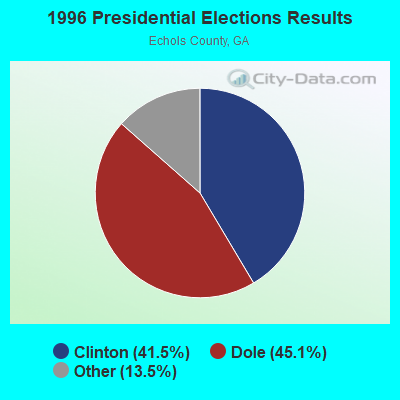

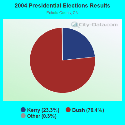
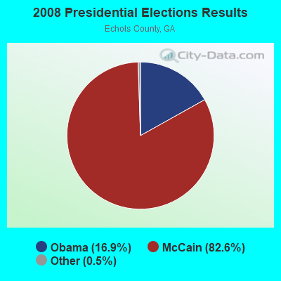
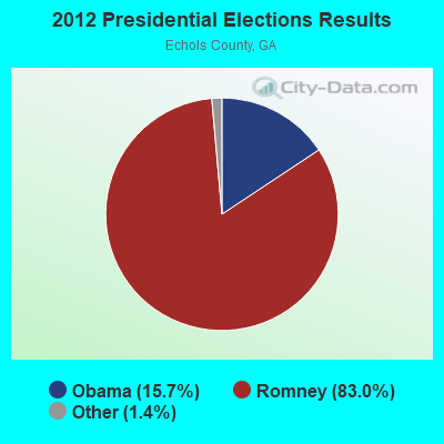
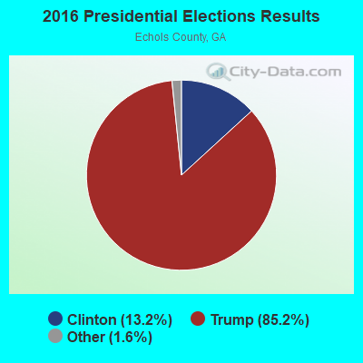

Graphs represent county-level data. Detailed 2008 Election Results
Religion statistics for West Echols, GA (based on Echols County data)

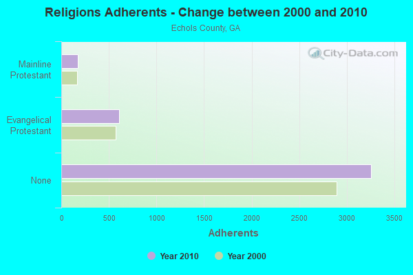
| Religion | Adherents | Congregations |
|---|---|---|
| Evangelical Protestant | 604 | 4 |
| Mainline Protestant | 172 | 2 |
| None | 3,258 | - |
Food Environment Statistics:
| Echols County: | 2.46 / 10,000 pop. |
| State: | 5.12 / 10,000 pop. |
| Here: | 9.2% |
| Georgia: | 10.4% |
| Echols County: | 28.8% |
| Georgia: | 27.8% |
| This county: | 19.4% |
| Georgia: | 14.6% |
Strongest AM radio stations in West Echols:
- WFVR (910 AM; 50 kW; VALDOSTA, GA; Owner: RAMA COMMUNICATIONS, INC.)
- WJEM (1150 AM; 5 kW; VALDOSTA, GA; Owner: WJEM, INC.)
- WTHV (810 AM; daytime; 2 kW; HAHIRA, GA; Owner: ETERNAL LIFE MINISTRIES, INC.)
- WGOV (950 AM; 4 kW; VALDOSTA, GA; Owner: W G O V, INC.)
- WOKV (690 AM; 50 kW; JACKSONVILLE, FL; Owner: COX RADIO, INC.)
- WSTT (730 AM; 25 kW; THOMASVILLE, GA; Owner: MARION R. WILLIAMS)
- WOBS (1530 AM; daytime; 50 kW; JACKSONVILLE, FL; Owner: WORD BROADCASTING NETWORK, INC.)
- WHGH (840 AM; daytime; 10 kW; THOMASVILLE, GA; Owner: H. G. H INVESTMENT CORP.)
- WGSR (1570 AM; 50 kW; FERNANDINA BEACH, FL; Owner: RJM COMMUNICATIONS, INC)
- WMGA (1130 AM; 10 kW; MOULTRIE, GA; Owner: RADIO MOULTRIE, INC.)
- WJEP (1020 AM; daytime; 10 kW; OCHLOCKNEE, GA; Owner: LIFELINE MINISTRIES, INCORPORATED)
- WFLF (540 AM; 50 kW; PINE HILLS, FL; Owner: CLEAR CHANNEL BROADCASTING LICENSES, INC.)
- WVLD (1450 AM; 1 kW; VALDOSTA, GA; Owner: RTG RADIO, LLC)
Strongest FM radio stations in West Echols:
- WHLJ (97.5 FM; STATENVILLE, GA; Owner: LATAURUS PRODUCTIONS INCORPORATED)
- WQPW (95.7 FM; VALDOSTA, GA; Owner: RTG RADIO, LLC)
- WVHT (105.7 FM; MONTICELLO, FL; Owner: WILSON BROADCASTING, INC.)
- WWRQ-FM (107.9 FM; VALDOSTA, GA; Owner: RTG RADIO, LLC)
- WAAC (92.9 FM; VALDOSTA, GA; Owner: WGOV, INC.)
- WAFT (101.1 FM; VALDOSTA, GA; Owner: CHRISTIAN RADIO FELLOWSHIP, INC.)
- WDMG-FM (99.5 FM; DOUGLAS, GA; Owner: RTG RADIO, LLC)
- WYZK (96.7 FM; VALDOSTA, GA; Owner: C. D. J., INC.)
- WWET (91.7 FM; VALDOSTA, GA; Owner: GEORGIA PUBLIC TELECOMMUNICATIONS COMMISSION)
- WJYF (95.3 FM; NASHVILLE, GA; Owner: TIFTON BROADCASTING CORP.)
- WXHT (102.7 FM; MADISON, FL; Owner: MAGNUM BROADCASTING, INC.)
- WKVH (91.9 FM; MONTICELLO, FL; Owner: EDUCATIONAL MEDIA FOUNDATION)
- WVGA (105.9 FM; LAKELAND, GA; Owner: RTG RADIO, LLC)
- WSTI-FM (105.3 FM; QUITMAN, GA; Owner: MAGNUM BROADCASTING, INC.)
- WBTY (98.7 FM; HOMERVILLE, GA; Owner: SOUTHERN BROADCASTING & INVESTMENT CO., INC.)
TV broadcast stations around West Echols:
- WBFL-CA (Channel 13; VALDOSTA, GA; Owner: WTLH LICENSE CORP.)
- WFXU (Channel 57; LIVE OAK, FL; Owner: WFXU LICENSE CORPORATION)
- WCTV (Channel 6; THOMASVILLE, GA; Owner: WCTV LICENSEE CORP.)
- WTWC-TV (Channel 40; TALLAHASSEE, FL; Owner: WTWC LICENSEE, LLC)
- W25CP (Channel 25; VALDOSTA, GA; Owner: TRINITY BROADCASTING NETWORK)
- WBVJ-LP (Channel 35; VALDOSTA, GA; Owner: WTLH LICENSE CORP.)
- WVAG (Channel 44; VALDOSTA, GA; Owner: HUTCHENS COMMUNICATIONS, INC.)

- 72.0%Electricity
- 19.6%Bottled, tank, or LP gas
- 6.3%Wood
- 2.0%Utility gas

- 67.0%Electricity
- 30.1%Bottled, tank, or LP gas
- 1.4%Utility gas
- 1.4%No fuel used
West Echols compared to Georgia state average:
- Median house value below state average.
- Unemployed percentage significantly below state average.
- Black race population percentage significantly below state average.
- Hispanic race population percentage above state average.
- Median age significantly below state average.
- Foreign-born population percentage significantly below state average.
- Length of stay since moving in significantly above state average.
- Number of rooms per house significantly below state average.
- House age significantly below state average.
- Number of college students below state average.
- Percentage of population with a bachelor's degree or higher below state average.
West Echols on our top lists:
- #16 on the list of "Top 101 cities with the most residents born in Chile (population 500+)"
- #40 on the list of "Top 101 counties with the lowest total withdrawal of fresh water for public supply"