Naylor, Georgia
Submit your own pictures of this place and show them to the world
- OSM Map
- General Map
- Google Map
- MSN Map

| Males: 1,656 | |
| Females: 1,766 |
| Median resident age: | 33.8 years |
| Georgia median age: | 33.4 years |
Zip code: 31636
| Naylor: | $52,143 |
| GA: | $72,837 |
Estimated per capita income in 2022: $24,136 (it was $14,256 in 2000)
Naylor CCD income, earnings, and wages data
Estimated median house or condo value in 2022: $159,095 (it was $61,600 in 2000)
| Naylor: | $159,095 |
| GA: | $297,400 |
Mean prices in 2022: all housing units: $235,143; detached houses: $252,266; townhouses or other attached units: $276,984; in 2-unit structures: $283,353; in 3-to-4-unit structures: $213,593; in 5-or-more-unit structures: $282,093; mobile homes: $89,056
Detailed information about poverty and poor residents in Naylor, GA


- 2,32574.9%White alone
- 69522.4%Black alone
- 371.2%Hispanic
- 210.7%Two or more races
- 200.6%American Indian alone
- 50.2%Asian alone
- 10.03%Native Hawaiian and Other
Pacific Islander alone

Races in Naylor detailed stats: ancestries, foreign born residents, place of birth
According to our research of Georgia and other state lists, there were 7 registered sex offenders living in Naylor, Georgia as of May 23, 2024.
The ratio of all residents to sex offenders in Naylor is 489 to 1.
The ratio of registered sex offenders to all residents in this city is lower than the state average.
 Recent articles from our blog. Our writers, many of them Ph.D. graduates or candidates, create easy-to-read articles on a wide variety of topics.
Current Local Time: EST time zone
Elevation: 192 feet
Land area: 102.3 square miles.
Population density: 33 people per square mile (very low).

| Naylor CCD: | 0.6% ($377) |
| Georgia: | 0.9% ($919) |
Nearest city with pop. 50,000+: Tallahassee, FL  (73.4 miles , pop. 150,624).
Nearest city with pop. 200,000+: Jacksonville, FL (96.1 miles , pop. 735,617).
Nearest city with pop. 1,000,000+: Houston, TX (734.6 miles , pop. 1,953,631).
Nearest cities:
), ), )Latitude: 30.87 N, Longitude: 83.14 W
Area code commonly used in this area: 229


| Here: | 3.0% |
| Georgia: | 2.9% |

- Construction (15.1%)
- Public administration (10.3%)
- Health care (9.8%)
- Educational services (8.7%)
- Food & beverage stores (6.3%)
- Food (3.9%)
- Truck transportation (3.7%)

- Construction (25.2%)
- Public administration (8.2%)
- Food & beverage stores (6.5%)
- Educational services (5.7%)
- Truck transportation (5.0%)
- Repair & maintenance (4.9%)
- Agriculture, forestry, fishing & hunting (4.5%)

- Health care (19.1%)
- Public administration (12.6%)
- Educational services (12.1%)
- Food & beverage stores (6.1%)
- Food (4.3%)
- Social assistance (4.3%)
- Construction (3.7%)

- Driver/sales workers and truck drivers (5.2%)
- Electrical equipment mechanics and other installation, maintenance, and repair workers, including supervisors (4.3%)
- Law enforcement workers, including supervisors (4.1%)
- Other sales and related occupations, including supervisors (4.1%)
- Other production occupations, including supervisors (3.6%)
- Health technologists and technicians (3.2%)
- Metal workers and plastic workers (3.2%)

- Electrical equipment mechanics and other installation, maintenance, and repair workers, including supervisors (7.0%)
- Driver/sales workers and truck drivers (6.9%)
- Law enforcement workers, including supervisors (6.2%)
- Metal workers and plastic workers (6.1%)
- Supervisors, construction and extraction workers (5.8%)
- Electricians (5.2%)
- Laborers and material movers, hand (4.6%)

- Health technologists and technicians (6.8%)
- Other office and administrative support workers, including supervisors (6.7%)
- Counselors, social workers, and other community and social service specialists (6.7%)
- Child care workers (6.2%)
- Other sales and related occupations, including supervisors (5.0%)
- Secretaries and administrative assistants (4.4%)
- Material recording, scheduling, dispatching, and distributing workers (4.3%)
Average climate in Naylor, Georgia
Based on data reported by over 4,000 weather stations


(lower is better)

Air Quality Index (AQI) level in 2023 was 78.1. This is about average.
| City: | 78.1 |
| U.S.: | 72.6 |

Particulate Matter (PM2.5) [µg/m3] level in 2023 was 10.6. This is worse than average. Closest monitor was 9.2 miles away from the city center.
| City: | 10.6 |
| U.S.: | 8.1 |

Lead (Pb) [µg/m3] level in 2008 was 0.00215. This is significantly better than average. Closest monitor was 8.6 miles away from the city center.
| City: | 0.00215 |
| U.S.: | 0.00931 |
Tornado activity:
Naylor-area historical tornado activity is slightly below Georgia state average. It is 1% smaller than the overall U.S. average.
On 4/19/1988, a category F3 (max. wind speeds 158-206 mph) tornado 23.9 miles away from the Naylor place center killed 4 people and injured 18 people and caused between $5,000,000 and $50,000,000 in damages.
On 5/11/1952, a category F3 tornado 35.1 miles away from the place center injured 10 people and caused between $500,000 and $5,000,000 in damages.
Earthquake activity:
Naylor-area historical earthquake activity is significantly above Georgia state average. It is 41% smaller than the overall U.S. average.On 8/2/1974 at 08:52:09, a magnitude 4.9 (4.3 MB, 4.9 LG, Class: Light, Intensity: IV - V) earthquake occurred 211.0 miles away from Naylor center
On 10/24/1997 at 08:35:17, a magnitude 4.9 (4.8 MB, 4.2 MS, 4.9 LG, Depth: 6.2 mi) earthquake occurred 245.6 miles away from Naylor center
On 11/22/1974 at 05:25:55, a magnitude 4.7 (4.7 MB) earthquake occurred 225.0 miles away from the city center
On 4/29/2003 at 08:59:39, a magnitude 4.9 (4.4 MB, 4.6 MW, 4.9 LG) earthquake occurred 289.4 miles away from Naylor center
On 1/18/1999 at 07:00:53, a magnitude 4.8 (4.8 MB, 4.0 LG, Depth: 0.6 mi) earthquake occurred 297.9 miles away from Naylor center
On 8/21/1992 at 16:31:55, a magnitude 4.4 (4.1 MB, 4.1 LG, 4.4 LG, Depth: 6.2 mi) earthquake occurred 232.8 miles away from Naylor center
Magnitude types: regional Lg-wave magnitude (LG), body-wave magnitude (MB), surface-wave magnitude (MS), moment magnitude (MW)
Natural disasters:
The number of natural disasters in Lowndes County (9) is smaller than the US average (15).Major Disasters (Presidential) Declared: 4
Emergencies Declared: 3
Causes of natural disasters: Storms: 4, Floods: 3, Tornadoes: 3, Winds: 2, Drought: 1, Hurricane: 1, Snowfall: 1, Tropical Storm: 1, Winter Storm: 1, Other: 1 (Note: some incidents may be assigned to more than one category).
Hospitals and medical centers near Naylor:
- GREENLEAF CENTER INC (Hospital, about 8 miles away; VALDOSTA, GA)
- CRESTWOOD NH (Nursing Home, about 9 miles away; VALDOSTA, GA)
- HOLLY HILL INTERMEDIATE CARE FACILITY (Nursing Home, about 9 miles away; VALDOSTA, GA)
- BETHANY HOSPICE LLC (Hospital, about 9 miles away; VALDOSTA, GA)
- LAKEHAVEN NH (Nursing Home, about 9 miles away; VALDOSTA, GA)
- PARKWOOD DEVELOPMENTAL CENTER ICF-MR (Hospital, about 9 miles away; VALDOSTA, GA)
- INTREPID USA HEALTHCARE SERVICES (Home Health Center, about 9 miles away; VALDOSTA, GA)
Airports located in Naylor:
- Christians Folly Airport (GE01) (Runways: 1)
Colleges/universities with over 2000 students nearest to Naylor:
- Valdosta State University (about 10 miles; Valdosta, GA; Full-time enrollment: 11,155)
- Wiregrass Georgia Technical College (about 13 miles; Valdosta, GA; FT enrollment: 3,246)
- South Georgia State College (about 47 miles; Douglas, GA; FT enrollment: 2,507)
- Abraham Baldwin Agricultural College (about 49 miles; Tifton, GA; FT enrollment: 2,564)
- Florida Gateway College (about 60 miles; Lake City, FL; FT enrollment: 2,179)
- Florida Agricultural and Mechanical University (about 75 miles; Tallahassee, FL; FT enrollment: 10,841)
- Florida State University (about 75 miles; Tallahassee, FL; FT enrollment: 38,283)
Points of interest:
Notable locations in Naylor: Lowndes County Fire and Rescue Service Headquarters (A), Naylor Volunteer Fire Department (B), Eastside Fire Department (C). Display/hide their locations on the map
Churches in Naylor include: Saint Luke Church (A), Good Hope Church (B), Mount Pleasant Church (C), Pleasant Way Church (D), Saint Marks Church (E), Saint Marys Church (F), Unity Church (G). Display/hide their locations on the map
Cemeteries: Green Cemetery (1), James Cemetery (2), Thomas Cemetery (3), Unity Cemetery (4), Sweet Prospect Cemetery (5), Wetherington Cemetery (6). Display/hide their locations on the map
Lakes and reservoirs: Boring Pond (A), Deloach Lake Dam (B). Display/hide their locations on the map
Streams, rivers, and creeks: Ty Ty Branch (A), Red Oak Branch (B), Ray Branch (C), Otter Creek (D), Meetinghouse Branch (E), Knights Creek (F). Display/hide their locations on the map
Drinking water stations with addresses in Naylor and their reported violations in the past:
BANKS LAKE POINTE SUBDIVISION (Population served: 186, Groundwater):Past monitoring violations:
- One routine major monitoring violation
| This place: | 2.7 people |
| Georgia: | 2.6 people |
| This place: | 75.8% |
| Whole state: | 68.5% |
| This place: | 5.0% |
| Whole state: | 5.9% |
Likely homosexual households (counted as self-reported same-sex unmarried-partner households)
- Lesbian couples: 0.5% of all households
- Gay men: 0.3% of all households
| This place: | 13.8% |
| Whole state: | 13.0% |
| This place: | 7.0% |
| Whole state: | 6.1% |
2 people in nursing homes in 2000
For population 15 years and over in Naylor:

- Never married: 17.2%
- Now married: 58.8%
- Separated: 2.5%
- Widowed: 6.8%
- Divorced: 17.2%
For population 25 years and over in Naylor:
- High school or higher: 70.4%
- Bachelor's degree or higher: 9.1%
- Graduate or professional degree: 2.5%
- Unemployed: 5.9%
- Mean travel time to work (commute): 22.4 minutes


| Here: | 13.4 |
| Georgia average: | 13.3 |
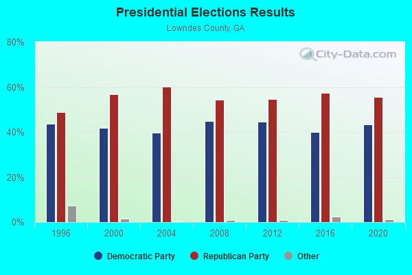
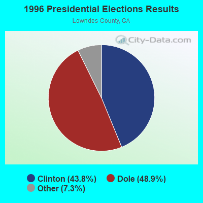
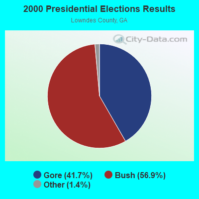

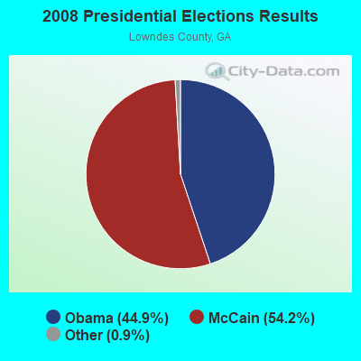
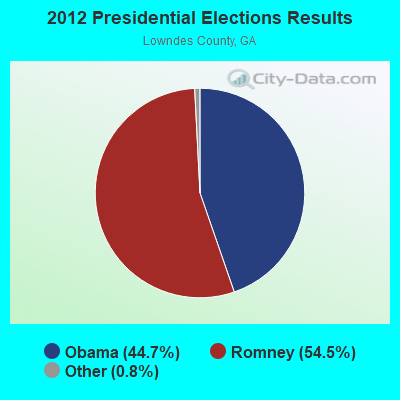
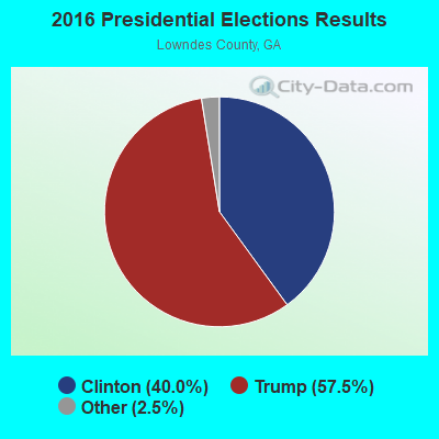
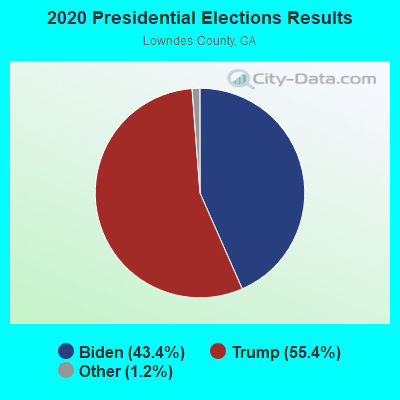
Graphs represent county-level data. Detailed 2008 Election Results
Religion statistics for Naylor, GA (based on Lowndes County data)
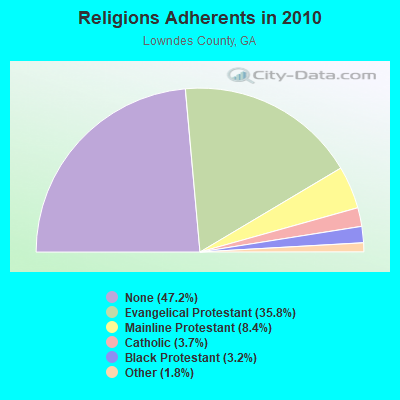
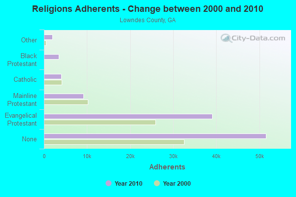
| Religion | Adherents | Congregations |
|---|---|---|
| Evangelical Protestant | 39,086 | 117 |
| Mainline Protestant | 9,152 | 23 |
| Catholic | 3,999 | 2 |
| Black Protestant | 3,491 | 17 |
| Other | 1,941 | 7 |
| None | 51,564 | - |
Food Environment Statistics:
| Lowndes County: | 1.28 / 10,000 pop. |
| Georgia: | 1.91 / 10,000 pop. |
| Lowndes County: | 0.20 / 10,000 pop. |
| Georgia: | 0.15 / 10,000 pop. |
| This county: | 1.67 / 10,000 pop. |
| Georgia: | 0.86 / 10,000 pop. |
| Lowndes County: | 6.20 / 10,000 pop. |
| Georgia: | 5.12 / 10,000 pop. |
| Lowndes County: | 8.07 / 10,000 pop. |
| State: | 7.41 / 10,000 pop. |
| Here: | 10.8% |
| Georgia: | 10.4% |
| Here: | 29.3% |
| State: | 27.8% |
| Lowndes County: | 16.4% |
| Georgia: | 14.6% |
9.63% of this county's 2021 resident taxpayers lived in other counties in 2020 ($45,444 average adjusted gross income)
| Here: | 9.63% |
| Georgia average: | 10.21% |
0.36% of residents moved from foreign countries ($1,847 average AGI)
Lowndes County: 0.36% Georgia average: 0.04%
Top counties from which taxpayers relocated into this county between 2020 and 2021:
| from Brooks County, GA | |
| from Lanier County, GA | |
| from Cook County, GA |
9.55% of this county's 2020 resident taxpayers moved to other counties in 2021 ($43,763 average adjusted gross income)
| Here: | 9.55% |
| Georgia average: | 9.60% |
0.26% of residents moved to foreign countries ($1,277 average AGI)
Lowndes County: 0.26% Georgia average: 0.03%
Top counties to which taxpayers relocated from this county between 2020 and 2021:
| to Brooks County, GA | |
| to Lanier County, GA | |
| to Cook County, GA |
Strongest AM radio stations in Naylor:
- WJEM (1150 AM; 5 kW; VALDOSTA, GA; Owner: WJEM, INC.)
- WTHV (810 AM; daytime; 2 kW; HAHIRA, GA; Owner: ETERNAL LIFE MINISTRIES, INC.)
- WFVR (910 AM; 50 kW; VALDOSTA, GA; Owner: RAMA COMMUNICATIONS, INC.)
- WGOV (950 AM; 4 kW; VALDOSTA, GA; Owner: W G O V, INC.)
- WOKV (690 AM; 50 kW; JACKSONVILLE, FL; Owner: COX RADIO, INC.)
- WSTT (730 AM; 25 kW; THOMASVILLE, GA; Owner: MARION R. WILLIAMS)
- WHGH (840 AM; daytime; 10 kW; THOMASVILLE, GA; Owner: H. G. H INVESTMENT CORP.)
- WVLD (1450 AM; 1 kW; VALDOSTA, GA; Owner: RTG RADIO, LLC)
- WMGA (1130 AM; 10 kW; MOULTRIE, GA; Owner: RADIO MOULTRIE, INC.)
- WOBS (1530 AM; daytime; 50 kW; JACKSONVILLE, FL; Owner: WORD BROADCASTING NETWORK, INC.)
- WJEP (1020 AM; daytime; 10 kW; OCHLOCKNEE, GA; Owner: LIFELINE MINISTRIES, INCORPORATED)
- WGSR (1570 AM; 50 kW; FERNANDINA BEACH, FL; Owner: RJM COMMUNICATIONS, INC)
- WMAC (940 AM; 50 kW; MACON, GA; Owner: CUMULUS LICENSING CORP.)
Strongest FM radio stations in Naylor:
- WHLJ (97.5 FM; STATENVILLE, GA; Owner: LATAURUS PRODUCTIONS INCORPORATED)
- WAAC (92.9 FM; VALDOSTA, GA; Owner: WGOV, INC.)
- WAFT (101.1 FM; VALDOSTA, GA; Owner: CHRISTIAN RADIO FELLOWSHIP, INC.)
- WDMG-FM (99.5 FM; DOUGLAS, GA; Owner: RTG RADIO, LLC)
- WWET (91.7 FM; VALDOSTA, GA; Owner: GEORGIA PUBLIC TELECOMMUNICATIONS COMMISSION)
- WQPW (95.7 FM; VALDOSTA, GA; Owner: RTG RADIO, LLC)
- WVGA (105.9 FM; LAKELAND, GA; Owner: RTG RADIO, LLC)
- WJYF (95.3 FM; NASHVILLE, GA; Owner: TIFTON BROADCASTING CORP.)
- WWRQ-FM (107.9 FM; VALDOSTA, GA; Owner: RTG RADIO, LLC)
- WYZK (96.7 FM; VALDOSTA, GA; Owner: C. D. J., INC.)
- WVHT (105.7 FM; MONTICELLO, FL; Owner: WILSON BROADCASTING, INC.)
- WKVH (91.9 FM; MONTICELLO, FL; Owner: EDUCATIONAL MEDIA FOUNDATION)
- WFSU-FM (88.9 FM; TALLAHASSEE, FL; Owner: FLORIDA STATE UNIVERSITY)
- WXVS (90.1 FM; WAYCROSS, GA; Owner: GEORGIA PUBLIC TELECOMMUNICATIONS COMMISSION)
- WDDQ (92.1 FM; ADEL, GA; Owner: WILLIAMS INVESTMENT COMPANY)
- WBTY (98.7 FM; HOMERVILLE, GA; Owner: SOUTHERN BROADCASTING & INVESTMENT CO., INC.)
- WXHT (102.7 FM; MADISON, FL; Owner: MAGNUM BROADCASTING, INC.)
- WSTI-FM (105.3 FM; QUITMAN, GA; Owner: MAGNUM BROADCASTING, INC.)
TV broadcast stations around Naylor:
- WBFL-CA (Channel 13; VALDOSTA, GA; Owner: WTLH LICENSE CORP.)
- WBVJ-LP (Channel 35; VALDOSTA, GA; Owner: WTLH LICENSE CORP.)
- W25CP (Channel 25; VALDOSTA, GA; Owner: TRINITY BROADCASTING NETWORK)
- WVAG (Channel 44; VALDOSTA, GA; Owner: HUTCHENS COMMUNICATIONS, INC.)
- WCTV (Channel 6; THOMASVILLE, GA; Owner: WCTV LICENSEE CORP.)
- WTWC-TV (Channel 40; TALLAHASSEE, FL; Owner: WTWC LICENSEE, LLC)
- WFXU (Channel 57; LIVE OAK, FL; Owner: WFXU LICENSE CORPORATION)
- WXGA-TV (Channel 8; WAYCROSS, GA; Owner: GEORGIA PUBLIC TELECOMMUNICATIONS COMMISSION)

Naylor fatal accident list:
Jan 16, 2018 09:45 AM, Us-Sr38, Lat: 30.881953, Lon: -83.146217, Vehicles: 3, Persons: 3, Fatalities: 1
Oct 26, 2017 06:45 PM, Glenn Road, Hickory Grove Road, Lat: 30.740619, Lon: -83.139072, Vehicles: 1, Persons: 1, Fatalities: 1
FCC Registered Antenna Towers:
18 (See the full list of FCC Registered Antenna Towers in Naylor)FCC Registered Commercial Land Mobile Towers:
1- Lat: 30.908528 Lon: -83.083750, Call Sign: WQAI220,
Assigned Frequencies: 450.281 MHz, 450.381 MHz, Grant Date: 06/04/2004, Expiration Date: 04/01/2028, Certifier: Warren Lee, Registrant: Graham Brock, Inc., St. Simons Island, GA 31522, Phone: (912) 638-8028, Fax: (912) 638-7722, Email:
FCC Registered Microwave Towers:
2- WHLJ Studio, 5852 Highway 84 East (Lat: 30.907250 Lon: -83.081306), Type: Tower, Structure height: 57.9 m, Call Sign: WPOS828,
Assigned Frequencies: 951.000 MHz, Grant Date: 03/26/1999, Expiration Date: 04/01/2028, Registrant: Graham Brock, Inc., St. Simons Island, GA 31522-7466, Phone: (912) 638-8028, Fax: (912) 638-7722, Email:
- Naylor Tower, 8751 Ga-135 (Lat: 30.908167 Lon: -83.078639), Type: Silo, Structure height: 29.3 m, Call Sign: WRWT425,
Assigned Frequencies: 10835.0 MHz, 10835.0 MHz, 11325.0 MHz, 11325.0 MHz, Grant Date: 03/27/2023, Expiration Date: 03/27/2033, Certifier: Daniel Weeks, Registrant: Intelpath, Hinsdale, IL 60522, Phone: (312) 841-9188, Email:
FCC Registered Amateur Radio Licenses:
5- Call Sign: KE4WMW, Licensee ID: L00496073, Grant Date: 01/14/2015, Expiration Date: 03/08/2025, Registrant: Jeffery W Ley, 621 S. Hwy.135, Naylor, GA 31641
- Call Sign: N4WCK, Licensee ID: L00247234, Grant Date: 02/19/1999, Expiration Date: 02/19/2009, Cancellation Date: 02/23/2011, Registrant: Richard W Frontera Sr, 8088 Georgia Hwy 135, Naylor, GA 31641
- Call Sign: KO4LTS, Licensee ID: L02342842, Grant Date: 02/01/2021, Expiration Date: 02/01/2031, Certifier: Steven Jolly, Registrant: Steven Jolly, 556 Ga Hwy 135 S, Naylor, GA 31641
- Call Sign: KO4SND, Licensee ID: L02473663, Grant Date: 08/10/2021, Expiration Date: 08/10/2031, Certifier: Michael B Roberts, Registrant: Michael B Roberts, 6758 Good Hope Circle, Naylor, GA 31641
- Call Sign: KQ4ATN, Licensee ID: L02562943, Grant Date: 05/25/2022, Expiration Date: 05/25/2032, Certifier: Daniel Haney, Registrant: Daniel Haney, 5919 Lake Shore Dr, Naylor, GA 31641-2563
FAA Registered Aircraft:
2- Aircraft: PIPER J3C-65 (Category: Land, Seats: 2, Weight: Up to 12,499 Pounds, Speed: 67 mph), Engine: CONT MOTOR A&C65 SERIES (65 HP) (Reciprocating)
N-Number: 42651, N42651, N-42651, Serial Number: 14942, Year manufactured: 1945, Certificate Issue Date: 08/30/1994
Registrant (Individual): Joe L Christian, 9339 Georgia Hwy 135n, Naylor, GA 31641 - Aircraft: STOLP STARDUSTER 2 (Category: Land, Weight: Up to 12,499 Pounds, Speed: 105 mph), Engine: LYCOMING O&VO-360 SER (180 HP) (Reciprocating)
N-Number: 44TD, N44TD, N-44TD, Serial Number: 1000, Year manufactured: 1973, Airworthiness Date: 05/09/1980, Certificate Issue Date: 10/16/1985
Registrant (Individual): Joe L Christian, 9339 Ga Highway 135, Naylor, GA 31641

- 73.2%Electricity
- 21.5%Bottled, tank, or LP gas
- 3.0%No fuel used
- 1.4%Utility gas
- 0.5%Wood
- 0.4%Fuel oil, kerosene, etc.

- 70.7%Electricity
- 15.0%Bottled, tank, or LP gas
- 12.1%Utility gas
- 2.1%Wood
Naylor compared to Georgia state average:
- Median house value below state average.
- Unemployed percentage below state average.
- Hispanic race population percentage significantly below state average.
- Median age below state average.
- Foreign-born population percentage significantly below state average.
- Renting percentage below state average.
- Length of stay since moving in significantly above state average.
- Number of rooms per house significantly below state average.
- House age significantly below state average.
- Percentage of population with a bachelor's degree or higher significantly below state average.
Naylor on our top lists:
- #32 on the list of "Top 101 cities with the most residents born in Other Central America (population 500+)"
- #75 on the list of "Top 101 cities with the most residents born in Honduras (population 500+)"
- #28 on the list of "Top 101 counties with the highest percentage of residents relocating to foreign countries in 2011"
- #45 on the list of "Top 101 counties with the highest percentage of residents relocating to other counties in 2011 (pop. 50,000+)"
- #46 on the list of "Top 101 counties with the highest percentage of residents relocating from foreign countries between 2010 and 2011"
- #61 on the list of "Top 101 counties with the highest percentage of residents relocating from other counties between 2010 and 2011 (pop. 50,000+)"