Tollesboro, Kentucky
Submit your own pictures of this place and show them to the world
- OSM Map
- General Map
- Google Map
- MSN Map

| Males: 1,649 | |
| Females: 1,603 |
| Median resident age: | 36.9 years |
| Kentucky median age: | 35.9 years |
Zip code: 41179
| Tollesboro: | $42,489 |
| KY: | $59,341 |
Estimated per capita income in 2022: $24,494 (it was $14,124 in 2000)
Tollesboro CCD income, earnings, and wages data
Estimated median house or condo value in 2022: $112,178 (it was $47,300 in 2000)
| Tollesboro: | $112,178 |
| KY: | $196,300 |
Detailed information about poverty and poor residents in Tollesboro, KY


Compare current foreclosures near Tollesboro, KY:
| Photo | Address | Area | Beds / Baths | Price | Details |
|---|---|---|---|---|---|

|
#1
Ky 57
Tollesboro, KY 41189
|
- sq. feet
|
1 baths 2 beds |
show details | |

|
#2
Ky 57
Tollesboro, KY 41189
|
- sq. feet
|
- baths - beds |
show details | |

|
#3
E 7th St
Manchester, OH 45144
|
1,000 sq. feet
|
1 baths 2 beds |
$74,900
|
show details |

|
#4
Ky Hwy 1234 S
Maysville, KY 41056
|
1,800 sq. feet
|
2 baths 3 beds |
$305,900
|
show details |

|
#5
Ballard St
West Union, OH 45693
|
960 sq. feet
|
1 baths 3 beds |
show details | |

|
#6
Mills Ave
Flemingsburg, KY 41041
|
1,588 sq. feet
|
2 baths 4 beds |
show details | |

|
#7
Wallingford Rd
Flemingsburg, KY 41041
|
1,456 sq. feet
|
2 baths 3 beds |
show details | |

|
#8
Rhodes Rd
Lynx, OH 45650
|
1,332 sq. feet
|
2 baths 3 beds |
show details | |

|
#9
Lexington Pike
Maysville, KY 41056
|
2,388 sq. feet
|
2 baths 4 beds |
show details | |

|
#10
Gatewood Dr
West Union, OH 45693
|
1,402 sq. feet
|
2 baths 3 beds |
show details |
| Photo | Address | Area | Beds / Baths | Price | Details |
|---|---|---|---|---|---|

|
#11
Walnut Ln
Maysville, KY 41056
|
2,016 sq. feet
|
2 baths 4 beds |
show details | |

|
#12
Alex Ln
West Union, OH 45693
|
1,120 sq. feet
|
2 baths 2 beds |
show details | |

|
#13
Kennedy Ave
West Union, OH 45693
|
1,536 sq. feet
|
2 baths 3 beds |
show details | |

|
#14
S Market St
West Union, OH 45693
|
1,335 sq. feet
|
1 baths 3 beds |
show details | |

|
#15
1st St
West Union, OH 45693
|
1,001 sq. feet
|
1 baths 3 beds |
show details | |

|
#16
Jersey Ridge Rd
Maysville, KY 41056
|
10,000 sq. feet
|
1 baths 2 beds |
show details | |

|
#17
Canebrake Dr
Maysville, KY 41056
|
1,050 sq. feet
|
1 baths 3 beds |
show details | |

|
#18
N Pole Rd
Ripley, OH 45167
|
1,008 sq. feet
|
1 baths 3 beds |
show details | |

|
#19
Hinton Dr
Maysville, KY 41056
|
1,640 sq. feet
|
2 baths 3 beds |
show details | |

|
#20
Joyce Ann Cir
Maysville, KY 41056
|
1,128 sq. feet
|
1 baths 3 beds |
show details |
| Photo | Address | Area | Beds / Baths | Price | Details |
|---|---|---|---|---|---|

|
#21
Bridge St
Maysville, KY 41056
|
1,870 sq. feet
|
1 baths 3 beds |
show details | |

|
#22
High Ridge Dr
Flemingsburg, KY 41041
|
880 sq. feet
|
2 baths 3 beds |
show details | |

|
#23
Marys Ave
Flemingsburg, KY 41041
|
960 sq. feet
|
1 baths 3 beds |
show details | |

|
#24
Meadowbrook Rd
Vanceburg, KY 41179
|
1 sq. feet
|
1 baths 3 beds |
show details | |

|
#25
Us Highway 62
Maysville, KY 41056
|
1,794 sq. feet
|
2 baths 3 beds |
show details | |

|
#26
Mark Dr
West Union, OH 45693
|
1,352 sq. feet
|
1 baths 3 beds |
show details | |

|
#27
E Ky 8
Vanceburg, KY 41179
|
1,900 sq. feet
|
2 baths 3 beds |
show details | |

|
#28
Cedarwood Dr
Maysville, KY 41056
|
1,377 sq. feet
|
2 baths 3 beds |
show details | |

|
#29
Bradley Dr
Flemingsburg, KY 41041
|
1,568 sq. feet
|
2 baths 3 beds |
show details | |

|
#30
Helena Rd
Mayslick, KY 41055
|
7,344 sq. feet
|
2 baths 3 beds |
show details |
| Photo | Address | Area | Beds / Baths | Price | Details |
|---|---|---|---|---|---|

|
#31
Mason Lewis Rd
Maysville, KY 41056
|
1,848 sq. feet
|
1 baths 3 beds |
show details | |

|
#32
Ash St
Maysville, KY 41056
|
1,320 sq. feet
|
1 baths 2 beds |
show details | |

|
#33
Commerce St
Maysville, KY 41056
|
1,040 sq. feet
|
1 baths 2 beds |
show details | |

|
#34
Cemetery St
Manchester, OH 45144
|
1,456 sq. feet
|
2 baths 3 beds |
show details | |

|
#35
Orangeburg Rd
Maysville, KY 41056
|
1,328 sq. feet
|
2 baths 2 beds |
show details | |

|
#36
Stonelick Rd
Maysville, KY 41056
|
1,812 sq. feet
|
1 baths 3 beds |
show details | |

|
#37
Mason Lewis Rd
Maysville, KY 41056
|
1,500 sq. feet
|
2 baths 4 beds |
show details | |

|
#38
Florence St
Maysville, KY 41056
|
870 sq. feet
|
1 baths 2 beds |
show details | |

|
#39
Mason Lewis Rd
Maysville, KY 41056
|
1,426 sq. feet
|
1 baths 3 beds |
show details | |

|
#40
Cottage St
Maysville, KY 41056
|
1,148 sq. feet
|
1 baths 3 beds |
show details |
| Photo | Address | Area | Beds / Baths | Price | Details |
|---|---|---|---|---|---|

|
#41
Broadway St
Maysville, KY 41056
|
1,470 sq. feet
|
1 baths 3 beds |
show details | |

|
#42
Ash St
Maysville, KY 41056
|
832 sq. feet
|
1 baths 2 beds |
show details | |

|
#43
Washington St
Aberdeen, OH 45101
|
1,032 sq. feet
|
1 baths - beds |
show details | |

|
#44
Ky 344
Wallingford, KY 41093
|
- sq. feet
|
- baths - beds |
show details | |

|
#45
W Elm St
Flemingsburg, KY 41041
|
- sq. feet
|
- baths - beds |
show details | |

|
#46
Polecat Pike
Maysville, KY 41056
|
- sq. feet
|
- baths - beds |
show details | |

|
#47
Rc Ln
Vanceburg, KY 41179
|
- sq. feet
|
- baths - beds |
show details | |

|
#48
Meadowbrook Rd
Vanceburg, KY 41179
|
- sq. feet
|
- baths - beds |
show details | |

|
#49
Lake Charles Dr
Maysville, KY 41056
|
- sq. feet
|
- baths - beds |
show details | |

|
Check over 1 million property listings on Foreclosure.com!
|
browse all offers | |||

- 3,22597.9%White alone
- 250.8%Two or more races
- 250.8%Hispanic
- 120.4%American Indian alone
- 50.2%Black alone
- 10.03%Asian alone

Races in Tollesboro detailed stats: ancestries, foreign born residents, place of birth
According to our research of Kentucky and other state lists, there were 4 registered sex offenders living in Tollesboro, Kentucky as of May 22, 2024.
The ratio of all residents to sex offenders in Tollesboro is 813 to 1.
The ratio of registered sex offenders to all residents in this city is lower than the state average.
 Recent articles from our blog. Our writers, many of them Ph.D. graduates or candidates, create easy-to-read articles on a wide variety of topics.
Current Local Time: EST time zone
Elevation: 816 feet
Land area: 129.7 square miles.
Population density: 25 people per square mile (very low).

| Tollesboro CCD: | 0.6% ($283) |
| Kentucky: | 0.8% ($610) |
Nearest city with pop. 50,000+: Huntington, WV  (61.0 miles , pop. 51,475).
Nearest city with pop. 200,000+: Cincinnati, OH (64.3 miles , pop. 331,285).
Nearest city with pop. 1,000,000+: Chicago, IL (313.7 miles , pop. 2,896,016).
Nearest cities:
), ), )Latitude: 38.59 N, Longitude: 83.54 W
Area code: 606


| Here: | 8.0% |
| Kentucky: | 3.8% |

- Agriculture, forestry, fishing & hunting (11.1%)
- Educational services (8.0%)
- Health care (7.2%)
- Transportation equipment (7.2%)
- Construction (6.6%)
- Truck transportation (5.5%)
- Machinery (5.4%)

- Agriculture, forestry, fishing & hunting (19.1%)
- Construction (11.3%)
- Truck transportation (7.3%)
- Machinery (6.5%)
- Transportation equipment (6.0%)
- Mining, quarrying, oil & gas extraction (5.2%)
- Educational services (4.8%)
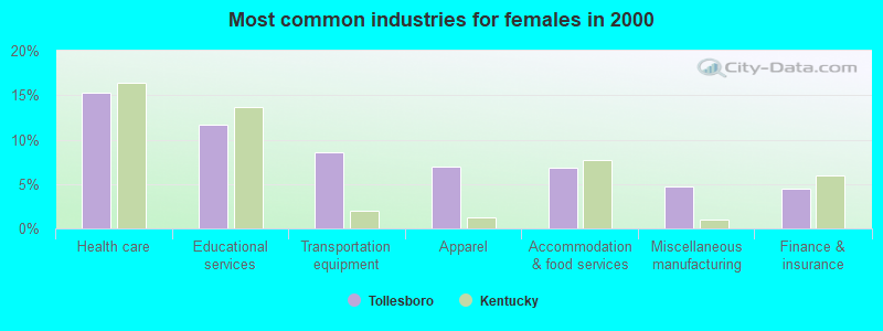
- Health care (15.3%)
- Educational services (11.6%)
- Transportation equipment (8.5%)
- Apparel (6.9%)
- Accommodation & food services (6.8%)
- Miscellaneous manufacturing (4.7%)
- Finance & insurance (4.4%)

- Farmers and farm managers (9.8%)
- Other production occupations, including supervisors (6.6%)
- Laborers and material movers, hand (6.4%)
- Driver/sales workers and truck drivers (5.1%)
- Metal workers and plastic workers (4.6%)
- Textile, apparel, and furnishings workers (4.4%)
- Assemblers and fabricators (4.2%)

- Farmers and farm managers (16.8%)
- Driver/sales workers and truck drivers (7.6%)
- Other production occupations, including supervisors (7.3%)
- Metal workers and plastic workers (7.1%)
- Laborers and material movers, hand (6.9%)
- Construction traders workers except carpenters, electricians, painters, plumbers, and construction laborers (4.3%)
- Construction laborers (3.9%)

- Textile, apparel, and furnishings workers (8.5%)
- Other office and administrative support workers, including supervisors (7.8%)
- Laborers and material movers, hand (5.7%)
- Cashiers (5.7%)
- Other production occupations, including supervisors (5.7%)
- Preschool, kindergarten, elementary, and middle school teachers (5.0%)
- Assemblers and fabricators (4.4%)
Average climate in Tollesboro, Kentucky
Based on data reported by over 4,000 weather stations


(lower is better)

Air Quality Index (AQI) level in 2020 was 57.1. This is better than average.
| City: | 57.1 |
| U.S.: | 72.6 |

Sulfur Dioxide (SO2) [ppb] level in 2020 was 0.213. This is significantly better than average. Closest monitor was 7.9 miles away from the city center.
| City: | 0.213 |
| U.S.: | 1.515 |

Particulate Matter (PM2.5) [µg/m3] level in 2020 was 7.41. This is about average. There were 0 monitors within city limits.
| City: | 7.41 |
| U.S.: | 8.11 |
Tornado activity:
Tollesboro-area historical tornado activity is slightly below Kentucky state average. It is 6% smaller than the overall U.S. average.
On 4/23/1968, a category F5 (max. wind speeds 261-318 mph) tornado 40.6 miles away from the Tollesboro place center killed 7 people and injured 93 people and caused between $500,000 and $5,000,000 in damages.
On 5/7/1967, a category F3 (max. wind speeds 158-206 mph) tornado 8.8 miles away from the place center caused between $5000 and $50,000 in damages.
Earthquake activity:
Tollesboro-area historical earthquake activity is significantly above Kentucky state average. It is 33% greater than the overall U.S. average.On 7/27/1980 at 18:52:21, a magnitude 5.2 (5.1 MB, 4.7 MS, 5.0 UK, 5.2 UK, Class: Moderate, Intensity: VI - VII) earthquake occurred 34.5 miles away from the city center
On 9/7/1988 at 02:28:09, a magnitude 4.6 (4.5 MB, 4.6 LG, Class: Light, Intensity: IV - V) earthquake occurred 35.9 miles away from Tollesboro center
On 8/23/2011 at 17:51:04, a magnitude 5.8 (5.8 MW, Depth: 3.7 mi) earthquake occurred 307.8 miles away from the city center
On 4/18/2008 at 09:36:59, a magnitude 5.4 (5.1 MB, 4.8 MS, 5.4 MW, 5.2 MW) earthquake occurred 235.5 miles away from the city center
On 8/9/2020 at 12:07:37, a magnitude 5.1 (5.1 MW, Depth: 4.7 mi) earthquake occurred 198.3 miles away from the city center
On 4/18/2008 at 09:36:59, a magnitude 5.2 (5.2 MW, Depth: 8.9 mi) earthquake occurred 235.5 miles away from the city center
Magnitude types: regional Lg-wave magnitude (LG), body-wave magnitude (MB), surface-wave magnitude (MS), moment magnitude (MW)
Natural disasters:
The number of natural disasters in Lewis County (26) is a lot greater than the US average (15).Major Disasters (Presidential) Declared: 22
Emergencies Declared: 3
Causes of natural disasters: Floods: 19, Storms: 16, Mudslides: 9, Tornadoes: 8, Winter Storms: 7, Landslides: 6, Snowstorms: 2, Blizzard: 1, Hurricane: 1, Snowfall: 1, Wind: 1, Other: 1 (Note: some incidents may be assigned to more than one category).
Hospitals and medical centers near Tollesboro:
- ADAMS COUNTY MANOR (Nursing Home, about 14 miles away; WEST UNION, OH)
- EAGLE CREEK NURSING CENTER (Nursing Home, about 14 miles away; WEST UNION, OH)
- CHESTNUT RIDGE CARE CENTER (Nursing Home, about 15 miles away; WEST UNION, OH)
- ADAMS COUNTY HOSPITAL (Hospital, about 15 miles away; WEST UNION, OH)
- ADAMS COUNTY HOSPITAL CARE CENTER (Nursing Home, about 15 miles away; WEST UNION, OH)
- MAYSVILLE EXTENDED CARE (Nursing Home, about 15 miles away; MAYSVILLE, KY)
- MAYSVILLE NURSING AND REHABILITATION FACILITY (Nursing Home, about 15 miles away; MAYSVILLE, KY)
Colleges/universities with over 2000 students nearest to Tollesboro:
- Maysville Community and Technical College (about 15 miles; Maysville, KY; Full-time enrollment: 2,969)
- Morehead State University (about 29 miles; Morehead, KY; FT enrollment: 7,523)
- Shawnee State University (about 31 miles; Portsmouth, OH; FT enrollment: 4,160)
- Southern State Community College (about 46 miles; Hillsboro, OH; FT enrollment: 2,418)
- Ashland Community and Technical College (about 49 miles; Ashland, KY; FT enrollment: 2,482)
- University of Cincinnati-Clermont College (about 50 miles; Batavia, OH; FT enrollment: 2,739)
- Northern Kentucky University (about 59 miles; Highland Heights, KY; FT enrollment: 12,059)
Private high school in Tollesboro:
Public elementary/middle school in Tollesboro:
- TOLLESBORO ELEMENTARY SCHOOL (Students: 295, Location: 2431 W. KY 10, Grades: PK-6)
Points of interest:
Notable locations in Tollesboro: Ruggles Camp (A), Wells Landing (B), Manchester Station Landing (C), Chalkley Station (D), Tollesboro Volunteer Fire Department (E). Display/hide their locations on the map
Churches in Tollesboro include: Fryes Church (A), Gallilee Church (B), Happy Hollow Church (C), Wesley Chapel (D), Mount Tabor Church (E), Mount Zion Church (F), Muses Chapel (G), Pine Grove Church (H), Pine Valley Church (I). Display/hide their locations on the map
Cemeteries: Mays Cemetery (1), Hackworth Cemetery (2), Cedar Leaf Cemetery (3), Burtonville Cemetery (4), Nash Cemetery (5), Pine Grove Cemetery (6), Fairmont Cemetery (7). Display/hide their locations on the map
Reservoir: Mitchell Lake (A). Display/hide its location on the map
Streams, rivers, and creeks: Buck Lick Branch (A), Toles Creek (B), Bethel Creek (C), Big Branch (D), Browns Run (E), Crooked Creek (F), Union Branch (G), Turkey Run (H), Clear Creek (I). Display/hide their locations on the map
Birthplace of: Lucille P. Markey - Philanthropist.
| This place: | 2.5 people |
| Kentucky: | 2.5 people |
| This place: | 73.2% |
| Whole state: | 66.9% |
| This place: | 6.6% |
| Whole state: | 6.4% |
Likely homosexual households (counted as self-reported same-sex unmarried-partner households)
- Lesbian couples: 0.4% of all households
- Gay men: 0.2% of all households
| This place: | 22.5% |
| Whole state: | 15.8% |
| This place: | 6.5% |
| Whole state: | 6.6% |
Banks with branches in Tollesboro (2011 data):
- Citizens Deposit Bank & Trust: Tollesboro Branch at State Highway 10, branch established on 1967/11/27. Info updated 2010/09/27: Bank assets: $212.9 mil, Deposits: $183.5 mil, headquarters in Vanceburg, KY, positive income, Commercial Lending Specialization, 9 total offices, Holding Company: Premier Financial Bancorp, Inc.
For population 15 years and over in Tollesboro:

- Never married: 20.1%
- Now married: 63.1%
- Separated: 1.5%
- Widowed: 6.4%
- Divorced: 10.3%
For population 25 years and over in Tollesboro:
- High school or higher: 63.8%
- Bachelor's degree or higher: 9.0%
- Graduate or professional degree: 5.1%
- Unemployed: 3.3%
- Mean travel time to work (commute): 33.3 minutes


| Here: | 15.4 |
| Kentucky average: | 13.8 |
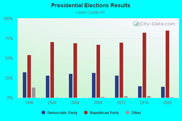
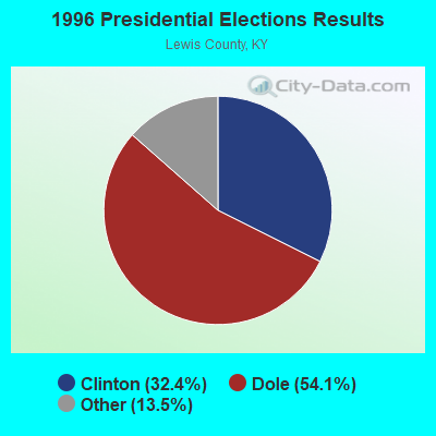


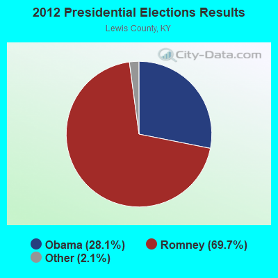
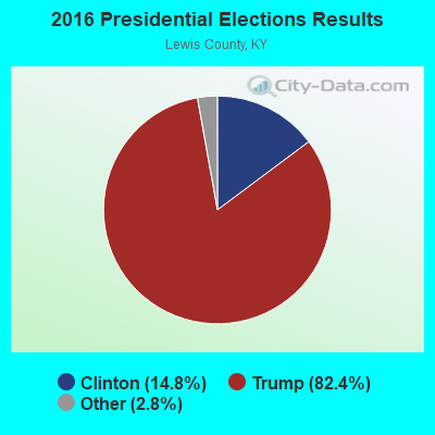
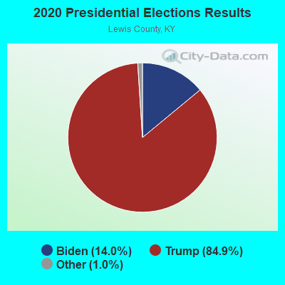
Graphs represent county-level data. Detailed 2008 Election Results
Religion statistics for Tollesboro, KY (based on Lewis County data)
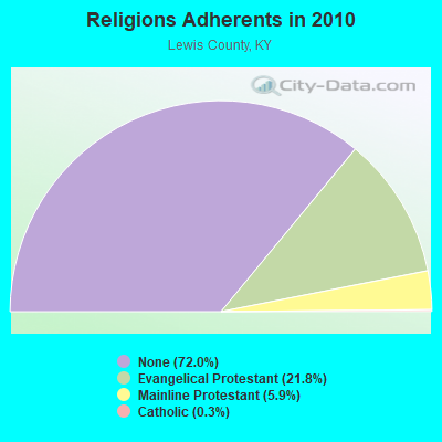
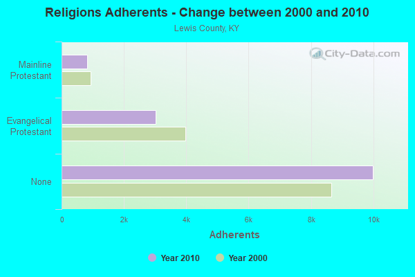
| Religion | Adherents | Congregations |
|---|---|---|
| Evangelical Protestant | 3,018 | 24 |
| Mainline Protestant | 819 | 8 |
| Catholic | 40 | 1 |
| None | 9,993 | - |
Food Environment Statistics:
| This county: | 5.05 / 10,000 pop. |
| Kentucky: | 2.19 / 10,000 pop. |
| This county: | 7.93 / 10,000 pop. |
| State: | 4.36 / 10,000 pop. |
| This county: | 2.88 / 10,000 pop. |
| State: | 5.74 / 10,000 pop. |
| This county: | 10.4% |
| Kentucky: | 11.0% |
| Lewis County: | 33.6% |
| State: | 30.0% |
| This county: | 16.4% |
| Kentucky: | 15.9% |
Strongest AM radio stations in Tollesboro:
- WLW (700 AM; 50 kW; CINCINNATI, OH; Owner: JACOR BROADCASTING CORPORATION)
- WTVN (610 AM; 50 kW; COLUMBUS, OH; Owner: CITICASTERS LICENSES, L.P.)
- WSAI (1530 AM; 50 kW; CINCINNATI, OH; Owner: JACOR BROADCASTING CORPORATION)
- WKKS (1570 AM; 1 kW; VANCEBURG, KY; Owner: BROWN COMMUNICATIONS, INC.)
- WHAS (840 AM; 50 kW; LOUISVILLE, KY; Owner: CLEAR CHANNEL BROADCASTING LICENSES, INC.)
- WFTM (1240 AM; 1 kW; MAYSVILLE, KY; Owner: STANDARD TABACCO CO.)
- WNXT (1260 AM; 5 kW; PORTSMOUTH, OH; Owner: HOMETOWN B/C OF PORTSMOUTH, INC.)
- WGOH (1370 AM; 5 kW; GRAYSON, KY; Owner: CARTER COUNTY BROADCASTING CO., INC.)
- WRFD (880 AM; daytime; 23 kW; COLUMBUS-WORTHINGTON, OH; Owner: SALEM MEDIA OF OHIO, INC.)
- WKRC (550 AM; 5 kW; CINCINNATI, OH; Owner: JACOR BROADCASTING CORPORATION)
- WLGC (1520 AM; daytime; 5 kW; GREENUP, KY; Owner: GREENUP COUNTY BROADCASTING, INC.)
- WFLE (1060 AM; daytime; 0 kW; FLEMINGSBURG, KY; Owner: FLEMING COUNTY BROADCASTING CO., INC)
- WLAP (630 AM; 5 kW; LEXINGTON, KY; Owner: CITICASTERS LICENSES, L.P.)
Strongest FM radio stations in Tollesboro:
- WAGX (101.3 FM; MANCHESTER, OH; Owner: JEWELL SCHAEFFER BROADCASTING CO.)
- WFLE-FM (95.1 FM; FLEMINGSBURG, KY; Owner: FLEMING COUNTY BROADCASTING CO., INC)
- WPAY-FM (104.1 FM; PORTSMOUTH, OH; Owner: RADIO STATIONS WPAY/WPFB, INC.)
- WOSP (91.5 FM; PORTSMOUTH, OH; Owner: THE OHIO STATE UNIVERSITY)
- WKKS-FM (104.9 FM; VANCEBURG, KY; Owner: BROWN COMMUNICATIONS, INC.)
- WMKY (90.3 FM; MOREHEAD, KY; Owner: MOREHEAD STATE UNIVERSITY)
- WFTM-FM (95.9 FM; MAYSVILLE, KY; Owner: STANDARD TOBACCO COMPANY, INC.)
- WRAC (103.1 FM; WEST UNION, OH; Owner: DREAMCATCHER COMMUNICATIONS, INC.)
- WBVX (92.1 FM; CARLISLE, KY; Owner: L.M. COMMUNICATIONS OF KENTUCKY, LLC)
- WVXW (89.5 FM; WEST UNION, OH; Owner: XAVIER UNIVERSITY)
- WOHP (88.3 FM; PORTSMOUTH, OH; Owner: THE CEDARVILLE UNIVERSITY)
- WOKE (98.3 FM; GARRISON, KY; Owner: BIG RIVER RADIO, INC.)
- WAOL (99.5 FM; RIPLEY, OH; Owner: RICHARD L. PLESSINGER, SR.)
- WBMK (88.5 FM; MOREHEAD, KY; Owner: AMERICAN FAMILY ASSOCIATION)
- WNXT-FM (99.3 FM; PORTSMOUTH, OH; Owner: HOMETOWN B/C OF PORTSMOUTH, INC.)
- WAXZ (97.7 FM; GEORGETOWN, OH; Owner: RICHARD L. PLESSINGER, SR.)
- W215AV (90.9 FM; SOUTH PORTSMOUTH, KY; Owner: CALVARY CHAPEL OF TWIN FALLS, INC.)
- WZZZ (107.5 FM; PORTSMOUTH, OH; Owner: HOMETOWN BROADCASTING OF PORTSMOUTH 2, INC.)
TV broadcast stations around Tollesboro:
- WPBO (Channel 42; PORTSMOUTH, OH; Owner: THE OHIO STATE UNIVERSITY)
- WHCP (Channel 30; PORTSMOUTH, OH; Owner: TELEVISION PROPERTIES, INC.)
- WUPX-TV (Channel 67; MOREHEAD, KY; Owner: PAXSON LEXINGTON LICENSE, INC.)
- WKMR (Channel 38; MOREHEAD, KY; Owner: KENTUCKY AUTHORITY FOR EDUCATIONAL TV)
- W17AY (Channel 17; SEAMAN, OH; Owner: TRANQUILITY COMMUNITY CHURCH)

FCC Registered Antenna Towers:
6- Mattherw J Wallack, 19838 W Ky 9 (Lat: 38.566944 Lon: -83.632944), Type: 83.5, Overall height: 82.3 m, Registrant: Aerial Erectors, LLC, Mwallack@blvdllc.Com, , Lowvi-lle, Phone: (315) 376-3333
- Katie Miller, 214 Lions Club Road (281376 / Aa Hwy Ky) (Lat: 38.559944 Lon: -83.591278), Type: 80.8, Structure height: 21135 m, Overall height: 77.7 m, Registrant: American Towers, LLC, Faa-Fcc@americantower.Com, , Wobur-n, Phone: (678) 265-6730
- Bridget Carter, 214 Lions Club Road (281376 / Aa Hwy Ky) (Lat: 38.559944 Lon: -83.591278), Type: 80.8, Structure height: 21135 m, Overall height: 77.7 m, Registrant: American Towers, LLC, Faa-Fcc@americantower.Com, , Wobur-n, Phone: (678) 265-6730
- Jacob T Chapman, 214 Lions Club Road (281376 / Aa Hwy Ky) (Lat: 38.559944 Lon: -83.591278), Type: 80.8, Structure height: 21135 m, Overall height: 77.7 m, Registrant: American Towers, LLC, Faa-Fcc@americantower.Com, , Wobur-n, Phone: (678) 265-6730
- Matt Wallack, 19838 W Ky 9 (Lat: 38.566944 Lon: -83.632944), Type: 83.5, Structure height: 21135 m, Overall height: 82.3 m, Registrant: Aerial Erectors, LLC, Mwallack@blvdllc.Com, , Lowvi-lle, Phone: (315) 376-3333
- ronald w hardymon, 323 English Oak Ln (Lat: 38.568917 Lon: -83.596917), Type: 6.2, Structure height: 21135 m, Overall height: 3 m, Registrant: Rons Radio, Ron6754@yahoo.Com, , Tolle-sboro, Phone: (606) 291-9482
FCC Registered Amateur Radio Licenses:
19 (See the full list of FCC Registered Amateur Radio Licenses in Tollesboro)FAA Registered Aircraft:
1- Aircraft: GEMINI TWIN PPC (Category: Land, Seats: 2, Weight: Up to 12,499 Pounds), Engine: ROTAX 582SER (65 HP) (2 Cycle)
N-Number: 2543Y, N2543Y, N-2543Y, Serial Number: 046, Year manufactured: 2007, Airworthiness Date: 09/05/2007, Certificate Issue Date: 11/22/2010
Registrant (Individual): Deron K Mullikin, 4099 Buck Lick Br, Tollesboro, KY 41189
2002 - 2018 National Fire Incident Reporting System (NFIRS) incidents
- Fire incident types reported to NFIRS in Tollesboro, KY
- 3830.4%Mobile Property/Vehicle Fires
- 3729.6%Outside Fires
- 2520.0%Structure Fires
- 2520.0%Other
 Based on the data from the years 2002 - 2018 the average number of fire incidents per year is 7. The highest number of fire incidents - 18 took place in 2016, and the least - 0 in 2007. The data has a constant trend.
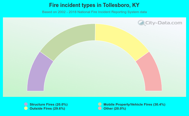 When looking into fire subcategories, the most incidents belonged to: Mobile Property/Vehicle Fires (30.4%), and Outside Fires (29.6%).
- 36.9%Electricity
- 25.0%Bottled, tank, or LP gas
- 20.3%Utility gas
- 16.0%Wood
- 1.7%Other fuel
- 0.2%Fuel oil, kerosene, etc.

- 32.3%Bottled, tank, or LP gas
- 29.1%Utility gas
- 19.1%Wood
- 17.3%Electricity
- 2.3%Fuel oil, kerosene, etc.
Tollesboro compared to Kentucky state average:
- Median house value below state average.
- Unemployed percentage significantly below state average.
- Black race population percentage significantly below state average.
- Hispanic race population percentage significantly below state average.
- Median age below state average.
- Foreign-born population percentage significantly below state average.
- Renting percentage below state average.
- Length of stay since moving in significantly above state average.
- Number of rooms per house significantly below state average.
- House age significantly below state average.
- Percentage of population with a bachelor's degree or higher below state average.

|
Total of 1 patent application in 2008-2024.