Laurel-Petersville, Kentucky
Submit your own pictures of this place and show them to the world
- OSM Map
- Google Map
- MSN Map
| Males: 1,026 | |
| Females: 1,012 |
| Median resident age: | 35.8 years |
| Kentucky median age: | 35.9 years |
Zip code: 41179
| Laurel-Petersville: | $31,803 |
| KY: | $59,341 |
Estimated per capita income in 2022: $15,634 (it was $9,015 in 2000)
Laurel-Petersville CCD income, earnings, and wages data
Estimated median house or condo value in 2022: $76,130 (it was $32,100 in 2000)
| Laurel-Petersville: | $76,130 |
| KY: | $196,300 |
Laurel-Petersville, KY residents, houses, and apartments details
Detailed information about poverty and poor residents in Laurel-Petersville, KY
Compare current foreclosures near your location:
| Photo | Address | Area | Beds / Baths | Price | Details |
|---|---|---|---|---|---|

|
#1
N Rhodes St
Pretty Prairie, KS 67570
|
1,725 sq. feet
|
2 baths 4 beds |
show details | |

|
#2
W 21st St N
Cheney, KS 67025
|
3,190 sq. feet
|
3 baths 5 beds |
show details | |

|
#3
NE Waterloo Ave
Murdock, KS 67111
|
1,220 sq. feet
|
1 baths 3 beds |
show details | |

|
#4
E Arlington Rd
Haven, KS 67543
|
960 sq. feet
|
1 baths 2 beds |
show details | |

|
#5
E Winterset St
Goddard, KS 67052
|
816 sq. feet
|
1 baths 2 beds |
show details | |

|
#6
W 39th St S
Goddard, KS 67052
|
4,221 sq. feet
|
3 baths 3 beds |
show details | |

|
#7
E 4th Ave Apt 1
Cheney, KS 67025
|
- sq. feet
|
- baths - beds |
show details | |

|
#8
SE Viney Ave
Murdock, KS 67111
|
- sq. feet
|
- baths - beds |
show details | |

|
#9
W Main St
Mount Hope, KS 67108
|
- sq. feet
|
- baths - beds |
show details | |

|
#10
N 189th Cir W
Colwich, KS 67030
|
- sq. feet
|
- baths - beds |
show details |
| Photo | Address | Area | Beds / Baths | Price | Details |
|---|---|---|---|---|---|

|
#11
N Main St
Goddard, KS 67052
|
- sq. feet
|
- baths - beds |
show details | |

|
#12
Martens Ct
Goddard, KS 67052
|
- sq. feet
|
- baths - beds |
show details | |

|
#13
W Maple St Lot D
Goddard, KS 67052
|
- sq. feet
|
- baths - beds |
show details | |

|
#14
S 339th St W
Cheney, KS 67025
|
- sq. feet
|
- baths - beds |
show details | |

|
#15
E Casey Dr
Goddard, KS 67052
|
- sq. feet
|
- baths - beds |
show details | |

|
Check over 1 million property listings on Foreclosure.com!
|
browse all offers | |||

- 2,05199.4%White alone
- 40.2%American Indian alone
- 40.2%Two or more races
- 50.2%Hispanic

Races in Laurel-Petersville detailed stats: ancestries, foreign born residents, place of birth
 Recent articles from our blog. Our writers, many of them Ph.D. graduates or candidates, create easy-to-read articles on a wide variety of topics.
Current Local Time: EST time zone
Land area: 165.8 square miles.
Population density: 12 people per square mile (very low).
| Laurel-Petersville CCD: | 0.6% ($199) |
| Kentucky: | 0.8% ($610) |
Nearest city with pop. 50,000+: Huntington, WV  (51.0 miles , pop. 51,475).
Nearest city with pop. 200,000+: Fayette, KY (66.8 miles , pop. 260,512).
Nearest city with pop. 1,000,000+: Chicago, IL (327.8 miles , pop. 2,896,016).
Nearest cities:
), ), ), ), ), )Latitude: 38.43 N, Longitude: 83.37 W
Area code commonly used in this area: 606

| Here: | 8.0% |
| Kentucky: | 3.8% |
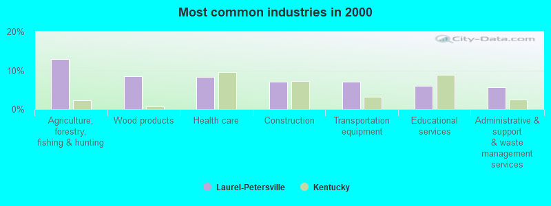
- Agriculture, forestry, fishing & hunting (12.9%)
- Wood products (8.5%)
- Health care (8.3%)
- Construction (7.1%)
- Transportation equipment (7.1%)
- Educational services (6.0%)
- Administrative & support & waste management services (5.6%)

- Agriculture, forestry, fishing & hunting (19.5%)
- Wood products (12.9%)
- Construction (9.7%)
- Administrative & support & waste management services (6.2%)
- Truck transportation (4.6%)
- Machinery (4.2%)
- Transportation equipment (4.2%)
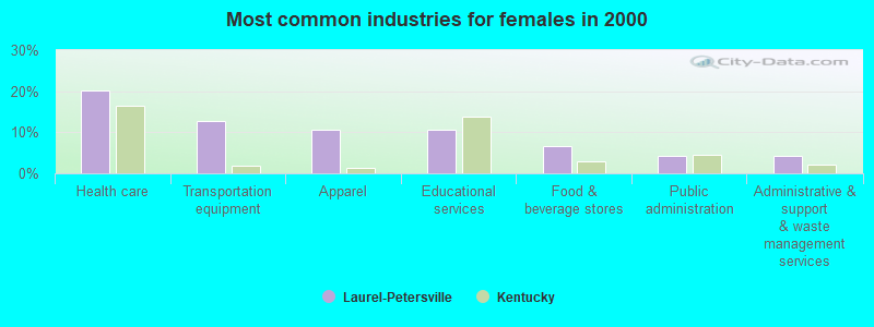
- Health care (20.2%)
- Transportation equipment (12.6%)
- Apparel (10.7%)
- Educational services (10.7%)
- Food & beverage stores (6.7%)
- Public administration (4.3%)
- Administrative & support & waste management services (4.3%)

- Fishing, hunting, and forestry occupations (9.5%)
- Other production occupations, including supervisors (9.3%)
- Metal workers and plastic workers (6.0%)
- Textile, apparel, and furnishings workers (5.3%)
- Vehicle and mobile equipment mechanics, installers, and repairers (5.2%)
- Other material moving workers, except laborers (4.9%)
- Electrical equipment mechanics and other installation, maintenance, and repair workers, including supervisors (3.9%)

- Fishing, hunting, and forestry occupations (14.3%)
- Other production occupations, including supervisors (11.3%)
- Vehicle and mobile equipment mechanics, installers, and repairers (7.8%)
- Metal workers and plastic workers (7.8%)
- Other material moving workers, except laborers (7.4%)
- Electrical equipment mechanics and other installation, maintenance, and repair workers, including supervisors (5.8%)
- Driver/sales workers and truck drivers (5.6%)

- Textile, apparel, and furnishings workers (13.4%)
- Cooks and food preparation workers (7.5%)
- Building and grounds cleaning and maintenance occupations (6.3%)
- Other production occupations, including supervisors (5.5%)
- Child care workers (5.1%)
- Registered nurses (4.7%)
- Nursing, psychiatric, and home health aides (4.3%)
Average climate in Laurel-Petersville, Kentucky
Based on data reported by over 4,000 weather stations


(lower is better)

Air Quality Index (AQI) level in 2022 was 56.0. This is better than average.
| City: | 56.0 |
| U.S.: | 72.6 |

Ozone [ppb] level in 2022 was 25.4. This is better than average. Closest monitor was 22.9 miles away from the city center.
| City: | 25.4 |
| U.S.: | 33.3 |

Particulate Matter (PM2.5) [µg/m3] level in 2022 was 6.85. This is about average. Closest monitor was 24.8 miles away from the city center.
| City: | 6.85 |
| U.S.: | 8.11 |
Tornado activity:
Laurel-Petersville-area historical tornado activity is below Kentucky state average. It is 21% smaller than the overall U.S. average.
On 4/23/1968, a category F5 (max. wind speeds 261-318 mph) tornado 36.3 miles away from the Laurel-Petersville place center killed 7 people and injured 93 people and caused between $500,000 and $5,000,000 in damages.
On 5/10/2003, a category F3 (max. wind speeds 158-206 mph) tornado 13.6 miles away from the place center injured 17 people and caused $6 million in damages.
Earthquake activity:
Laurel-Petersville-area historical earthquake activity is significantly above Kentucky state average. It is 31% greater than the overall U.S. average.On 7/27/1980 at 18:52:21, a magnitude 5.2 (5.1 MB, 4.7 MS, 5.0 UK, 5.2 UK, Class: Moderate, Intensity: VI - VII) earthquake occurred 34.5 miles away from Laurel-Petersville center
On 9/7/1988 at 02:28:09, a magnitude 4.6 (4.5 MB, 4.6 LG, Class: Light, Intensity: IV - V) earthquake occurred 33.8 miles away from Laurel-Petersville center
On 8/23/2011 at 17:51:04, a magnitude 5.8 (5.8 MW, Depth: 3.7 mi) earthquake occurred 297.9 miles away from Laurel-Petersville center
On 8/9/2020 at 12:07:37, a magnitude 5.1 (5.1 MW, Depth: 4.7 mi) earthquake occurred 184.3 miles away from the city center
On 4/18/2008 at 09:36:59, a magnitude 5.4 (5.1 MB, 4.8 MS, 5.4 MW, 5.2 MW) earthquake occurred 244.4 miles away from Laurel-Petersville center
On 4/18/2008 at 09:36:59, a magnitude 5.2 (5.2 MW, Depth: 8.9 mi) earthquake occurred 244.4 miles away from Laurel-Petersville center
Magnitude types: regional Lg-wave magnitude (LG), body-wave magnitude (MB), surface-wave magnitude (MS), moment magnitude (MW)
Natural disasters:
The number of natural disasters in Lewis County (26) is a lot greater than the US average (15).Major Disasters (Presidential) Declared: 22
Emergencies Declared: 3
Causes of natural disasters: Floods: 19, Storms: 16, Mudslides: 9, Tornadoes: 8, Winter Storms: 7, Landslides: 6, Snowstorms: 2, Blizzard: 1, Hurricane: 1, Snowfall: 1, Wind: 1, Other: 1 (Note: some incidents may be assigned to more than one category).
Colleges/universities with over 2000 students nearest to Laurel-Petersville:
- Morehead State University (about 17 miles; Morehead, KY; Full-time enrollment: 7,523)
- Maysville Community and Technical College (about 28 miles; Maysville, KY; FT enrollment: 2,969)
- Shawnee State University (about 30 miles; Portsmouth, OH; FT enrollment: 4,160)
- Ashland Community and Technical College (about 40 miles; Ashland, KY; FT enrollment: 2,482)
- Marshall University (about 52 miles; Huntington, WV; FT enrollment: 11,450)
- Southern State Community College (about 58 miles; Hillsboro, OH; FT enrollment: 2,418)
- Big Sandy Community and Technical College (about 61 miles; Prestonsburg, KY; FT enrollment: 2,660)
Points of interest:
Notable locations in Laurel-Petersville: Washman Lookout (A), Henderson Shelter (B), Head of Grassy (C), Huckleberry Tower (D), Camp Dix Volunteer Fire Department (E), Kinniconick Volunteer Fire Department (F). Display/hide their locations on the map
Churches in Laurel-Petersville include: Laurel Point Church (A), Nolan Church (B), Golden Ridge Church (C), Union Church (D), Thackers Chapel (E), Oak Ridge Church (F), Blankenship Church (G), Saylor Branch Church (H), Cedar Grove Church (I). Display/hide their locations on the map
Cemeteries: Thorp Cemetery (1), McEldowney Cemetery (2), Rayburn Community Cemetery (3), Million Cemetery (4), Esham Cemetery (5), Holly Cemetery (6), McCoy Cemetery (7). Display/hide their locations on the map
Streams, rivers, and creeks: Bark Branch (A), Barrett Branch (B), Big Chestnut Lick (C), Buck Lick Branch (D), Blue Ridge Fork (E), Boles Fork (F), Bradford Branch (G), Brandy Lick (H), Deep Hole Branch (I). Display/hide their locations on the map
| This place: | 2.6 people |
| Kentucky: | 2.5 people |
| This place: | 75.2% |
| Whole state: | 66.9% |
| This place: | 4.8% |
| Whole state: | 6.4% |
Likely homosexual households (counted as self-reported same-sex unmarried-partner households)
- Lesbian couples: 0.4% of all households
- Gay men: 0.4% of all households
| This place: | 27.1% |
| Whole state: | 15.8% |
| This place: | 12.3% |
| Whole state: | 6.6% |
For population 15 years and over in Laurel-Petersville:

- Never married: 18.5%
- Now married: 67.7%
- Separated: 2.6%
- Widowed: 6.7%
- Divorced: 7.1%
For population 25 years and over in Laurel-Petersville:
- High school or higher: 52.7%
- Bachelor's degree or higher: 3.3%
- Graduate or professional degree: 0.7%
- Unemployed: 10.8%
- Mean travel time to work (commute): 35.5 minutes


| Here: | 14.8 |
| Kentucky average: | 13.8 |
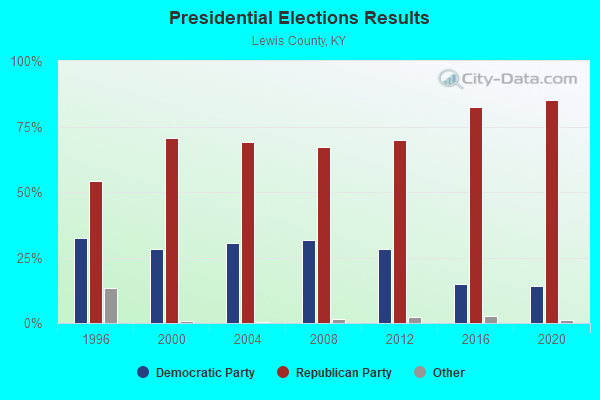
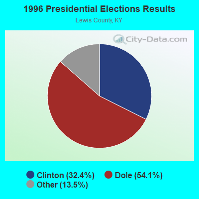


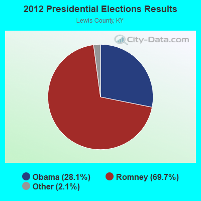
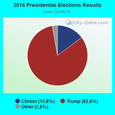
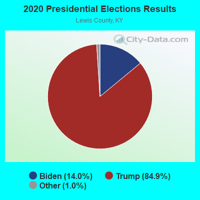
Graphs represent county-level data. Detailed 2008 Election Results
Religion statistics for Laurel-Petersville, KY (based on Lewis County data)
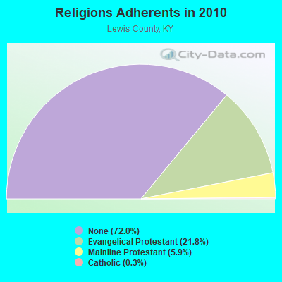
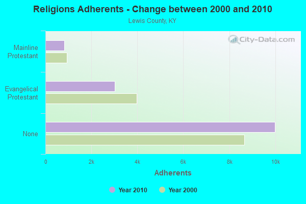
| Religion | Adherents | Congregations |
|---|---|---|
| Evangelical Protestant | 3,018 | 24 |
| Mainline Protestant | 819 | 8 |
| Catholic | 40 | 1 |
| None | 9,993 | - |
Food Environment Statistics:
| Lewis County: | 5.05 / 10,000 pop. |
| State: | 2.19 / 10,000 pop. |
| This county: | 7.93 / 10,000 pop. |
| State: | 4.36 / 10,000 pop. |
| Lewis County: | 2.88 / 10,000 pop. |
| Kentucky: | 5.74 / 10,000 pop. |
| Lewis County: | 10.4% |
| State: | 11.0% |
| This county: | 33.6% |
| Kentucky: | 30.0% |
| This county: | 16.4% |
| Kentucky: | 15.9% |
Strongest AM radio stations in Laurel-Petersville:
- WTVN (610 AM; 50 kW; COLUMBUS, OH; Owner: CITICASTERS LICENSES, L.P.)
- WLW (700 AM; 50 kW; CINCINNATI, OH; Owner: JACOR BROADCASTING CORPORATION)
- WGOH (1370 AM; 5 kW; GRAYSON, KY; Owner: CARTER COUNTY BROADCASTING CO., INC.)
- WSAI (1530 AM; 50 kW; CINCINNATI, OH; Owner: JACOR BROADCASTING CORPORATION)
- WKKS (1570 AM; 1 kW; VANCEBURG, KY; Owner: BROWN COMMUNICATIONS, INC.)
- WHAS (840 AM; 50 kW; LOUISVILLE, KY; Owner: CLEAR CHANNEL BROADCASTING LICENSES, INC.)
- WLGC (1520 AM; daytime; 5 kW; GREENUP, KY; Owner: GREENUP COUNTY BROADCASTING, INC.)
- WNXT (1260 AM; 5 kW; PORTSMOUTH, OH; Owner: HOMETOWN B/C OF PORTSMOUTH, INC.)
- WKYH (600 AM; 5 kW; PAINTSVILLE, KY; Owner: HIGHLANDS BROADCASTING CORPORATION)
- WVHU (800 AM; 5 kW; HUNTINGTON, WV; Owner: CAPSTAR TX LIMITED PARTNERSHIP)
- WRVC (930 AM; 5 kW; HUNTINGTON, WV; Owner: FIFTH AVENUE BROADCASTING COMPANY, INC.)
- WMOR (1330 AM; daytime; 1 kW; MOREHEAD, KY; Owner: MORGAN COUNTY INDUSTRIES, INC.)
- WRFD (880 AM; daytime; 23 kW; COLUMBUS-WORTHINGTON, OH; Owner: SALEM MEDIA OF OHIO, INC.)
Strongest FM radio stations in Laurel-Petersville:
- WFLE-FM (95.1 FM; FLEMINGSBURG, KY; Owner: FLEMING COUNTY BROADCASTING CO., INC)
- WMKY (90.3 FM; MOREHEAD, KY; Owner: MOREHEAD STATE UNIVERSITY)
- WPAY-FM (104.1 FM; PORTSMOUTH, OH; Owner: RADIO STATIONS WPAY/WPFB, INC.)
- WOSP (91.5 FM; PORTSMOUTH, OH; Owner: THE OHIO STATE UNIVERSITY)
- WBMK (88.5 FM; MOREHEAD, KY; Owner: AMERICAN FAMILY ASSOCIATION)
- WKKS-FM (104.9 FM; VANCEBURG, KY; Owner: BROWN COMMUNICATIONS, INC.)
- WOKE (98.3 FM; GARRISON, KY; Owner: BIG RIVER RADIO, INC.)
- WQXX (106.1 FM; MOREHEAD, KY; Owner: MORGAN COUNTY INDUSTRIES, INC.)
- WOHP (88.3 FM; PORTSMOUTH, OH; Owner: THE CEDARVILLE UNIVERSITY)
- WIVY (96.3 FM; MOREHEAD, KY; Owner: GATEWAY RADIO WORKS, INC.)
- WBVX (92.1 FM; CARLISLE, KY; Owner: L.M. COMMUNICATIONS OF KENTUCKY, LLC)
- WNXT-FM (99.3 FM; PORTSMOUTH, OH; Owner: HOMETOWN B/C OF PORTSMOUTH, INC.)
- WAGX (101.3 FM; MANCHESTER, OH; Owner: JEWELL SCHAEFFER BROADCASTING CO.)
- W215AV (90.9 FM; SOUTH PORTSMOUTH, KY; Owner: CALVARY CHAPEL OF TWIN FALLS, INC.)
- WZZZ (107.5 FM; PORTSMOUTH, OH; Owner: HOMETOWN BROADCASTING OF PORTSMOUTH 2, INC.)
- WUGO (102.3 FM; GRAYSON, KY; Owner: CARTER COUNTY BROADCASTING CO., INC.)
- WLGC-FM (105.7 FM; GREENUP, KY; Owner: GREENUP COUNTY BROADCASTING, INC.)
TV broadcast stations around Laurel-Petersville:
- WKMR (Channel 38; MOREHEAD, KY; Owner: KENTUCKY AUTHORITY FOR EDUCATIONAL TV)
- WPBO (Channel 42; PORTSMOUTH, OH; Owner: THE OHIO STATE UNIVERSITY)
- WUPX-TV (Channel 67; MOREHEAD, KY; Owner: PAXSON LEXINGTON LICENSE, INC.)
- WHCP (Channel 30; PORTSMOUTH, OH; Owner: TELEVISION PROPERTIES, INC.)

- 34.5%Electricity
- 33.9%Wood
- 28.4%Bottled, tank, or LP gas
- 2.5%Fuel oil, kerosene, etc.
- 0.7%No fuel used

- 54.3%Wood
- 23.5%Electricity
- 16.0%Fuel oil, kerosene, etc.
- 6.2%Bottled, tank, or LP gas
Laurel-Petersville compared to Kentucky state average:
- Median household income below state average.
- Median house value significantly below state average.
- Black race population percentage significantly below state average.
- Hispanic race population percentage significantly below state average.
- Median age below state average.
- Foreign-born population percentage significantly below state average.
- Renting percentage below state average.
- Length of stay since moving in significantly above state average.
- Number of rooms per house significantly below state average.
- House age significantly below state average.
- Number of college students significantly below state average.
- Percentage of population with a bachelor's degree or higher significantly below state average.