Station Camp, Kentucky
Submit your own pictures of this place and show them to the world
- OSM Map
- General Map
- Google Map
- MSN Map

| Males: 953 | |
| Females: 908 |
| Median resident age: | 35.9 years |
| Kentucky median age: | 35.9 years |
Zip code: 40336
| Station Camp: | $36,819 |
| KY: | $59,341 |
Estimated per capita income in 2022: $18,753 (it was $10,385 in 2000)
Station Camp CCD income, earnings, and wages data
Estimated median house or condo value in 2022: $88,212 (it was $35,500 in 2000)
| Station Camp: | $88,212 |
| KY: | $196,300 |
Detailed information about poverty and poor residents in Station Camp, KY


- 1,87898.2%White alone
- 221.2%Hispanic
- 90.5%Two or more races
- 30.2%American Indian alone
- 10.05%Asian alone

Races in Station Camp detailed stats: ancestries, foreign born residents, place of birth
 Recent articles from our blog. Our writers, many of them Ph.D. graduates or candidates, create easy-to-read articles on a wide variety of topics.
Current Local Time: EST time zone
Land area: 63.6 square miles.
Population density: 29 people per square mile (very low).

| Station Camp CCD: | 0.6% ($199) |
| Kentucky: | 0.8% ($610) |
Nearest city with pop. 50,000+: Fayette, KY  (40.9 miles , pop. 260,512).
Nearest city with pop. 1,000,000+: Chicago, IL (352.9 miles , pop. 2,896,016).
Nearest cities:
), ), ), ), )Latitude: 37.61 N, Longitude: 83.97 W
Area code commonly used in this area: 606


| Here: | 4.7% |
| Kentucky: | 3.8% |

- Construction (12.1%)
- Apparel (8.0%)
- Accommodation & food services (7.0%)
- Food & beverage stores (5.5%)
- Health care (5.2%)
- Agriculture, forestry, fishing & hunting (4.8%)
- Data processing, libraries, other information services (3.7%)

- Construction (19.7%)
- Accommodation & food services (7.5%)
- Agriculture, forestry, fishing & hunting (6.4%)
- Machinery (5.5%)
- Miscellaneous manufacturing (4.9%)
- Food & beverage stores (4.9%)
- Mining, quarrying, oil & gas extraction (4.6%)

- Apparel (18.8%)
- Health care (9.0%)
- Data processing, libraries, other information services (8.6%)
- Transportation equipment (6.3%)
- Food & beverage stores (6.3%)
- Accommodation & food services (6.3%)
- Personal & laundry services (6.3%)

- Other production occupations, including supervisors (9.8%)
- Electrical equipment mechanics and other installation, maintenance, and repair workers, including supervisors (6.2%)
- Metal workers and plastic workers (5.5%)
- Textile, apparel, and furnishings workers (4.7%)
- Vehicle and mobile equipment mechanics, installers, and repairers (4.3%)
- Other sales and related occupations, including supervisors (4.3%)
- Construction traders workers except carpenters, electricians, painters, plumbers, and construction laborers (4.0%)

- Electrical equipment mechanics and other installation, maintenance, and repair workers, including supervisors (9.2%)
- Vehicle and mobile equipment mechanics, installers, and repairers (7.5%)
- Other production occupations, including supervisors (7.5%)
- Construction traders workers except carpenters, electricians, painters, plumbers, and construction laborers (6.9%)
- Metal workers and plastic workers (6.6%)
- Other sales and related occupations, including supervisors (4.9%)
- Farmers and farm managers (4.6%)

- Other production occupations, including supervisors (12.9%)
- Textile, apparel, and furnishings workers (11.0%)
- Assemblers and fabricators (8.6%)
- Cashiers (6.3%)
- Registered nurses (5.9%)
- Retail sales workers, except cashiers (5.1%)
- Other office and administrative support workers, including supervisors (5.1%)
Average climate in Station Camp, Kentucky
Based on data reported by over 4,000 weather stations


Tornado activity:
Station Camp-area historical tornado activity is below Kentucky state average. It is 15% smaller than the overall U.S. average.
On 4/3/1974, a category F4 (max. wind speeds 207-260 mph) tornado 29.6 miles away from the Station Camp place center killed 7 people and injured 28 people.
On 6/9/1961, a category F3 (max. wind speeds 158-206 mph) tornado 8.5 miles away from the place center killed one person and injured 63 people and caused between $500,000 and $5,000,000 in damages.
Earthquake activity:
Station Camp-area historical earthquake activity is significantly above Kentucky state average. It is 62% greater than the overall U.S. average.On 7/27/1980 at 18:52:21, a magnitude 5.2 (5.1 MB, 4.7 MS, 5.0 UK, 5.2 UK, Class: Moderate, Intensity: VI - VII) earthquake occurred 41.1 miles away from Station Camp center
On 9/7/1988 at 02:28:09, a magnitude 4.6 (4.5 MB, 4.6 LG, Class: Light, Intensity: IV - V) earthquake occurred 37.1 miles away from the city center
On 4/18/2008 at 09:36:59, a magnitude 5.4 (5.1 MB, 4.8 MS, 5.4 MW, 5.2 MW) earthquake occurred 221.3 miles away from the city center
On 8/9/2020 at 12:07:37, a magnitude 5.1 (5.1 MW, Depth: 4.7 mi) earthquake occurred 176.9 miles away from the city center
On 8/23/2011 at 17:51:04, a magnitude 5.8 (5.8 MW, Depth: 3.7 mi) earthquake occurred 330.3 miles away from Station Camp center
On 4/18/2008 at 09:36:59, a magnitude 5.2 (5.2 MW, Depth: 8.9 mi) earthquake occurred 221.3 miles away from Station Camp center
Magnitude types: regional Lg-wave magnitude (LG), body-wave magnitude (MB), surface-wave magnitude (MS), moment magnitude (MW)
Natural disasters:
The number of natural disasters in Estill County (26) is a lot greater than the US average (15).Major Disasters (Presidential) Declared: 20
Emergencies Declared: 3
Causes of natural disasters: Floods: 18, Storms: 15, Mudslides: 9, Tornadoes: 9, Winter Storms: 7, Landslides: 6, Winds: 4, Snowstorms: 2, Blizzard: 1, Freeze: 1, Hurricane: 1, Snow: 1, Snowfall: 1, Other: 1 (Note: some incidents may be assigned to more than one category).
Colleges/universities with over 2000 students nearest to Station Camp:
- Eastern Kentucky University (about 21 miles; Richmond, KY; Full-time enrollment: 13,525)
- Bluegrass Community and Technical College (about 41 miles; Lexington, KY; FT enrollment: 8,560)
- University of Kentucky (about 42 miles; Lexington, KY; FT enrollment: 23,517)
- Morehead State University (about 50 miles; Morehead, KY; FT enrollment: 7,523)
- Hazard Community and Technical College (about 51 miles; Hazard, KY; FT enrollment: 2,087)
- Somerset Community College (about 53 miles; Somerset, KY; FT enrollment: 4,698)
- University of the Cumberlands (about 62 miles; Williamsburg, KY; FT enrollment: 3,585)
Points of interest:
Notable location: Barker Point (A). Display/hide its location on the map
Churches in Station Camp include: Clay Hill Church (A), Barnes Mountain Church (B), Wagersville Church (C), New Bethel Church (D), Nazareth Mission (E), Macedonia Church (F), Greenbriar Church (G), Grace Chapel (H). Display/hide their locations on the map
Cemeteries: Peters Cemetery (1), Noland Cemetery (2), Marcum Cemetery (3), King Cemetery (4), Hoover Cemetery (5), Gabbard Cemetery (6), Robinson Cemetery (7). Display/hide their locations on the map
Streams, rivers, and creeks: Crooked Creek (A), Edwards Branch (B), Elk Branch (C), Jenkins Branch (D), Jones Branch (E), Kissey Branch (F), Little Doe Creek (G), Long Branch (H), Sang Branch (I). Display/hide their locations on the map
| This place: | 2.6 people |
| Kentucky: | 2.5 people |
| This place: | 60.1% |
| Whole state: | 69.8% |
| This place: | 4.7% |
| Whole state: | 4.5% |
Likely homosexual households (counted as self-reported same-sex unmarried-partner households)
- Lesbian couples: 0.4% of all households
- Gay men: 0.1% of all households
| This place: | 27.1% |
| Whole state: | 15.8% |
| This place: | 9.1% |
| Whole state: | 6.6% |
For population 15 years and over in Station Camp:

- Never married: 24.8%
- Now married: 61.0%
- Separated: 1.8%
- Widowed: 5.9%
- Divorced: 8.4%
For population 25 years and over in Station Camp:
- High school or higher: 46.2%
- Bachelor's degree or higher: 3.3%
- Graduate or professional degree: 0.4%
- Unemployed: 7.3%
- Mean travel time to work (commute): 36.7 minutes


| Here: | 18.6 |
| Kentucky average: | 13.8 |
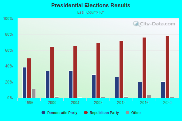
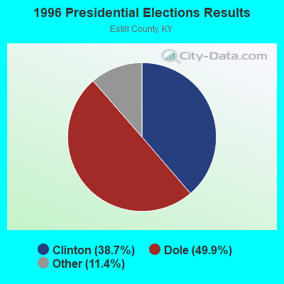
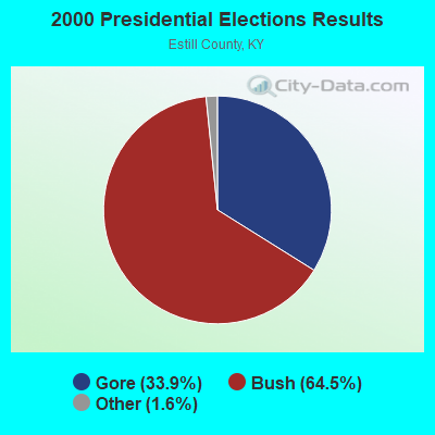
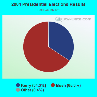
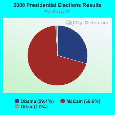
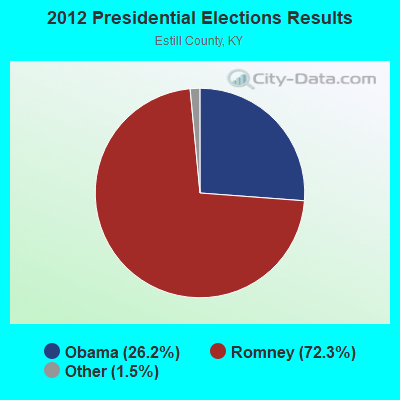
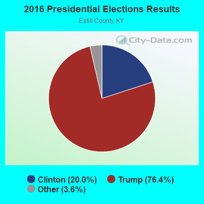
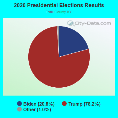
Graphs represent county-level data. Detailed 2008 Election Results
Religion statistics for Station Camp, KY (based on Estill County data)
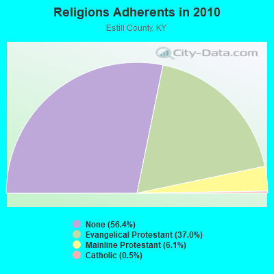
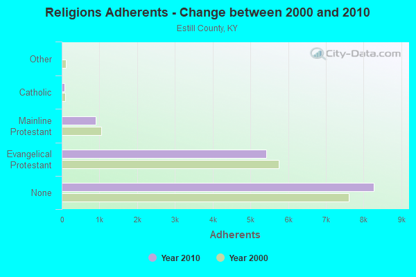
| Religion | Adherents | Congregations |
|---|---|---|
| Evangelical Protestant | 5,423 | 33 |
| Mainline Protestant | 897 | 7 |
| Catholic | 73 | 1 |
| Other | 3 | 1 |
| None | 8,276 | - |
Food Environment Statistics:
| Estill County: | 2.01 / 10,000 pop. |
| Kentucky: | 2.19 / 10,000 pop. |
| Estill County: | 3.34 / 10,000 pop. |
| State: | 4.36 / 10,000 pop. |
| This county: | 3.34 / 10,000 pop. |
| Kentucky: | 5.74 / 10,000 pop. |
| Here: | 12.4% |
| State: | 11.0% |
| This county: | 29.1% |
| State: | 30.0% |
| This county: | 18.4% |
| Kentucky: | 15.9% |
Strongest AM radio stations in Station Camp:
- WIRV (1550 AM; 1 kW; IRVINE, KY; Owner: KENTUCKY RIVER BROADCASTING CO., INC)
- WMTC (730 AM; 5 kW; VANCLEVE, KY; Owner: THE KENTUCKY MOUNTAIN HOLINESS ASSN.)
- WHAS (840 AM; 50 kW; LOUISVILLE, KY; Owner: CLEAR CHANNEL BROADCASTING LICENSES, INC.)
- WEKG (810 AM; daytime; 5 kW; JACKSON, KY; Owner: INTERMOUNTAIN B/CING CO., INC.)
- WKVL (850 AM; daytime; 50 kW; KNOXVILLE, TN; Owner: HORNE RADIO, LLC)
- WLW (700 AM; 50 kW; CINCINNATI, OH; Owner: JACOR BROADCASTING CORPORATION)
- WLAP (630 AM; 5 kW; LEXINGTON, KY; Owner: CITICASTERS LICENSES, L.P.)
- WTVN (610 AM; 50 kW; COLUMBUS, OH; Owner: CITICASTERS LICENSES, L.P.)
- WVLK (590 AM; 5 kW; LEXINGTON, KY; Owner: CUMULUS LICENSING CORP.)
- WKLB (1290 AM; 5 kW; MANCHESTER, KY; Owner: BARKER BROADCASTING COMPANY, INC.)
- WSAI (1530 AM; 50 kW; CINCINNATI, OH; Owner: JACOR BROADCASTING CORPORATION)
- WXRA (1580 AM; 10 kW; GEORGETOWN, KY; Owner: CITICASTERS LICENSES, L.P.)
- WMJR (1380 AM; 2 kW; WINCHESTER, KY; Owner: THY KINGDOM COME NETWORK, INC)
Strongest FM radio stations in Station Camp:
- WCYO (100.7 FM; IRVINE, KY; Owner: KENTUCKY RIVER BROADCASTING CO.)
- WSKV-FM (104.9 FM; STANTON, KY; Owner: PARKS BROADCASTING, INC.)
- WLJC (102.1 FM; BEATTYVILLE, KY; Owner: HOUR OF HARVEST, INCORPORATED)
- WLFX (106.7 FM; BEREA, KY; Owner: WALLINGFORD COMMUNICATIONS, LLC)
- WWAG (107.9 FM; MCKEE, KY; Owner: DANDY BROADCASTING, INC.)
- WEKU (88.9 FM; RICHMOND, KY; Owner: EASTERN KENTUCKY UNIVERSITY)
- WTBK (105.7 FM; MANCHESTER, KY; Owner: MANCHESTER COMMUNICATIONS, INC.)
- WJSN-FM (106.5 FM; JACKSON, KY; Owner: INTERMOUNTAIN BROADCASTING CO.)
- WSGS (101.1 FM; HAZARD, KY; Owner: MOUNTAIN BROADCASTING SERVICE, INC.)
- WUKY (91.3 FM; LEXINGTON, KY; Owner: BD. OF TRUSTEES UNIV. OF KENTUCKY)
- WLRO (101.5 FM; RICHMOND, KY; Owner: CUMULUS LICENSING CORP.)
- WVLK-FM (92.9 FM; LEXINGTON, KY; Owner: CUMULUS LICENSING CORP.)
- WYGE (92.3 FM; LONDON, KY; Owner: ETHEL HUFF BROADCASTING, LLC)
- WOCS (88.3 FM; LEROSE, KY; Owner: BOARD OF REGENTS - MOREHEAD STATE UNIVERSITY)
- WCBJ (103.7 FM; CAMPTON, KY; Owner: MORGAN COUNTY INDUSTRIES INC)
TV broadcast stations around Station Camp:
- WLJC-TV (Channel 65; BEATTYVILLE, KY; Owner: HOUR OF HARVEST, INC.)
- WUPX-TV (Channel 67; MOREHEAD, KY; Owner: PAXSON LEXINGTON LICENSE, INC.)
- WLEX-TV (Channel 18; LEXINGTON, KY; Owner: WLEX COMMUNICATIONS, L.L.C.)
- W26BK (Channel 26; TALBERT, KY; Owner: MS COMMUNICATIONS, LLC)
- W16BI (Channel 16; TALBERT, KY; Owner: MS COMMUNICATIONS, LLC)
- WKLE (Channel 46; LEXINGTON, KY; Owner: KENTUCKY AUTHORITY FOR EDUCATIONAL TV)
- WBLU-LP (Channel 62; LEXINGTON, KY; Owner: SANDRA B. POWLEY)
- WDKY-TV (Channel 56; DANVILLE, KY; Owner: WDKY LICENSEE, LLC)
- WKYT-TV (Channel 27; LEXINGTON, KY; Owner: WKYT LICENSEE CORP.)
- WTVQ-TV (Channel 36; LEXINGTON, KY; Owner: MEDIA GENERAL COMMUNICATIONS, INC.)
- W64CM (Channel 64; TALBERT, KY; Owner: MS COMMUNICATIONS, LLC)
- W66DA (Channel 66; TALBERT, KY; Owner: MS COMMUNICATIONS, LLC)

- 32.5%Electricity
- 30.3%Bottled, tank, or LP gas
- 22.9%Wood
- 13.0%Utility gas
- 1.2%Other fuel

- 35.3%Wood
- 27.6%Bottled, tank, or LP gas
- 23.1%Electricity
- 10.3%Utility gas
- 3.8%Fuel oil, kerosene, etc.
Station Camp compared to Kentucky state average:
- Median household income below state average.
- Median house value below state average.
- Unemployed percentage below state average.
- Black race population percentage significantly below state average.
- Hispanic race population percentage significantly below state average.
- Median age below state average.
- Foreign-born population percentage significantly below state average.
- Renting percentage significantly below state average.
- Length of stay since moving in significantly above state average.
- Number of rooms per house significantly below state average.
- House age significantly below state average.
- Number of college students significantly below state average.
- Percentage of population with a bachelor's degree or higher significantly below state average.