Sturgeon, Kentucky
Submit your own pictures of this place and show them to the world
- OSM Map
- General Map
- Google Map
- MSN Map

| Males: 499 | |
| Females: 475 |
| Median resident age: | 40.4 years |
| Kentucky median age: | 35.9 years |
Zip code: 41314
| Sturgeon: | $33,835 |
| KY: | $59,341 |
Estimated per capita income in 2022: $14,487 (it was $7,910 in 2000)
Sturgeon CCD income, earnings, and wages data
Estimated median house or condo value in 2022: $68,891 (it was $27,300 in 2000)
| Sturgeon: | $68,891 |
| KY: | $196,300 |
Mean prices in 2022: all housing units: $100,466; detached houses: $109,258; mobile homes: $60,670
Detailed information about poverty and poor residents in Sturgeon, KY
Compare current foreclosures near Sturgeon, KY:
| Photo | Address | Area | Beds / Baths | Price | Details |
|---|---|---|---|---|---|

|
#1
Highway 30 E
Tyner, KY 40486
|
1,493 sq. feet
|
1 baths 4 beds |
show details | |

|
#2
Ells Branch Rd
Manchester, KY 40962
|
1,436 sq. feet
|
2 baths 3 beds |
show details | |

|
#3
Crane Creek Rd
Manchester, KY 40962
|
1,792 sq. feet
|
2 baths 3 beds |
show details | |

|
#4
Ball Rd
Manchester, KY 40962
|
864 sq. feet
|
1 baths 2 beds |
show details | |

|
#5
Pleasant Grove Loop
Manchester, KY 40962
|
800 sq. feet
|
1 baths 3 beds |
show details | |

|
#6
Robinson Creek Rd
Manchester, KY 40962
|
720 sq. feet
|
1 baths 2 beds |
show details | |

|
#7
N Highway 421, Ste 2
Manchester, KY 40962
|
1,056 sq. feet
|
1 baths 2 beds |
show details | |

|
#8
Pipe Mudd Rd
Jackson, KY 41339
|
- sq. feet
|
- baths - beds |
show details | |

|
#9
Turkey Foot Rd
Mc Kee, KY 40447
|
- sq. feet
|
- baths - beds |
show details | |

|
#10
Wagersville Rd
Irvine, KY 40336
|
- sq. feet
|
- baths - beds |
show details |
| Photo | Address | Area | Beds / Baths | Price | Details |
|---|---|---|---|---|---|

|
#11
Highway 3630
Annville, KY 40402
|
- sq. feet
|
- baths - beds |
show details | |

|
#12
Right Fork Millcreek Rd
Beattyville, KY 41311
|
- sq. feet
|
- baths - beds |
show details | |

|
#13
Ray Mathis Rd
Annville, KY 40402
|
- sq. feet
|
- baths - beds |
show details | |

|
#14
Aj Johnson Rd
Annville, KY 40402
|
- sq. feet
|
- baths - beds |
show details | |

|
#15
Lawson Hill Rd
Beattyville, KY 41311
|
- sq. feet
|
- baths - beds |
show details | |

|
#16
Azelia Rd
Manchester, KY 40962
|
1,280 sq. feet
|
- baths - beds |
show details | |

|
#17
Highway 421 N
Mc Kee, KY 40447
|
- sq. feet
|
- baths - beds |
show details | |

|
#18
Highway 89 N
Mc Kee, KY 40447
|
- sq. feet
|
- baths - beds |
show details | |

|
#19
Highway 2003
Mc Kee, KY 40447
|
- sq. feet
|
- baths - beds |
show details | |

|
#20
Manor Dr Apt A5
Beattyville, KY 41311
|
- sq. feet
|
- baths - beds |
show details |
| Photo | Address | Area | Beds / Baths | Price | Details |
|---|---|---|---|---|---|

|
#21
Roberts Ct Apt 150
Mc Kee, KY 40447
|
- sq. feet
|
- baths - beds |
show details | |

|
#22
Highway 2004
Mc Kee, KY 40447
|
- sq. feet
|
- baths - beds |
show details | |

|
#23
Billy Riley Rd
Booneville, KY 41314
|
- sq. feet
|
- baths - beds |
show details | |

|
#24
Ccc Bottom Rd
Mc Kee, KY 40447
|
- sq. feet
|
- baths - beds |
show details | |

|
#25
Fox Hollow Rd
Manchester, KY 40962
|
1,960 sq. feet
|
- baths - beds |
show details | |

|
#26
Ridgeway E
Mc Kee, KY 40447
|
- sq. feet
|
- baths - beds |
show details | |

|
#27
Welchburg Estates Rd
Annville, KY 40402
|
- sq. feet
|
- baths - beds |
show details | |

|
#28
Hughes Fork Rd
Mc Kee, KY 40447
|
- sq. feet
|
- baths - beds |
show details | |

|
#29
Highway 421 S
Mc Kee, KY 40447
|
- sq. feet
|
- baths - beds |
show details | |

|
#30
Highway 30 E
Tyner, KY 40486
|
- sq. feet
|
- baths - beds |
show details |
| Photo | Address | Area | Beds / Baths | Price | Details |
|---|---|---|---|---|---|

|
#31
Leger Fork Rd
Tyner, KY 40486
|
- sq. feet
|
- baths - beds |
show details | |

|
#32
Carter Ln
Tyner, KY 40486
|
- sq. feet
|
- baths - beds |
show details | |

|
#33
Pryse Rd
Irvine, KY 40336
|
- sq. feet
|
- baths - beds |
show details | |

|
#34
Jarve Hollow Rd
Manchester, KY 40962
|
- sq. feet
|
- baths - beds |
show details | |

|
#35
Highway 399
Beattyville, KY 41311
|
- sq. feet
|
- baths - beds |
show details | |

|
#36
Old Highway 11
Beattyville, KY 41311
|
- sq. feet
|
- baths - beds |
show details | |

|
#37
Walk Log Br
Jackson, KY 41339
|
- sq. feet
|
- baths - beds |
show details | |

|
#38
Hellard Rd
Annville, KY 40402
|
- sq. feet
|
- baths - beds |
show details | |

|
#39
Dunaway Rd
Beattyville, KY 41311
|
- sq. feet
|
- baths - beds |
show details | |

|
#40
Highway 3447
Mc Kee, KY 40447
|
- sq. feet
|
- baths - beds |
show details |
| Photo | Address | Area | Beds / Baths | Price | Details |
|---|---|---|---|---|---|

|
#41
Highway 2003
Mc Kee, KY 40447
|
- sq. feet
|
- baths - beds |
show details | |

|
#42
Roark Rd
Annville, KY 40402
|
- sq. feet
|
- baths - beds |
show details | |

|
#43
Conway Rd
Tyner, KY 40486
|
- sq. feet
|
- baths - beds |
show details | |

|
#44
Sturgeon Rd
Tyner, KY 40486
|
- sq. feet
|
- baths - beds |
show details | |

|
#45
Highway 2003
Mc Kee, KY 40447
|
- sq. feet
|
- baths - beds |
show details | |

|
Check over 1 million property listings on Foreclosure.com!
|
browse all offers | |||

- 1,00998.2%White alone
- 90.9%Hispanic
- 80.8%Two or more races
- 10.10%Black alone
- 10.10%Asian alone

Races in Sturgeon detailed stats: ancestries, foreign born residents, place of birth
 Recent articles from our blog. Our writers, many of them Ph.D. graduates or candidates, create easy-to-read articles on a wide variety of topics.
Current Local Time: EST time zone
Land area: 78.6 square miles.
Population density: 12 people per square mile (very low).

| Sturgeon CCD: | 0.9% ($258) |
| Kentucky: | 0.8% ($610) |
Nearest city with pop. 50,000+: Fayette, KY  (58.1 miles , pop. 260,512).
Nearest city with pop. 1,000,000+: Chicago, IL (370.1 miles , pop. 2,896,016).
Nearest cities:
), ), ), ), )Latitude: 37.42 N, Longitude: 83.77 W
Area code commonly used in this area: 606


| Here: | 6.6% |
| Kentucky: | 3.8% |

- Miscellaneous manufacturing (14.6%)
- Construction (11.9%)
- Health care (11.1%)
- Computer & electronic products (10.0%)
- Mining, quarrying, oil & gas extraction (6.1%)
- Administrative & support & waste management services (6.1%)
- Public administration (5.4%)

- Construction (20.9%)
- Miscellaneous manufacturing (12.2%)
- Mining, quarrying, oil & gas extraction (10.8%)
- Administrative & support & waste management services (10.8%)
- Computer & electronic products (7.4%)
- Public administration (6.8%)
- Agriculture, forestry, fishing & hunting (6.1%)

- Health care (22.1%)
- Miscellaneous manufacturing (17.7%)
- Computer & electronic products (13.3%)
- Social assistance (7.1%)
- Textile mills & textile products (6.2%)
- Pharmacies & drug stores (5.3%)
- Educational services (5.3%)

- Assemblers and fabricators (14.9%)
- Laborers and material movers, hand (6.9%)
- Extraction workers (6.1%)
- Supervisors, construction and extraction workers (5.7%)
- Nursing, psychiatric, and home health aides (5.0%)
- Other production occupations, including supervisors (4.6%)
- Construction laborers (3.8%)

- Laborers and material movers, hand (12.2%)
- Extraction workers (10.8%)
- Assemblers and fabricators (10.8%)
- Supervisors, construction and extraction workers (10.1%)
- Construction laborers (6.8%)
- Driver/sales workers and truck drivers (6.1%)
- Vehicle and mobile equipment mechanics, installers, and repairers (5.4%)

- Assemblers and fabricators (20.4%)
- Other production occupations, including supervisors (10.6%)
- Registered nurses (8.0%)
- Nursing, psychiatric, and home health aides (8.0%)
- Other management occupations, except farmers and farm managers (8.0%)
- Child care workers (7.1%)
- Textile, apparel, and furnishings workers (6.2%)
Average climate in Sturgeon, Kentucky
Based on data reported by over 4,000 weather stations


Tornado activity:
Sturgeon-area historical tornado activity is below Kentucky state average. It is 30% smaller than the overall U.S. average.
On 6/9/1961, a category F3 (max. wind speeds 158-206 mph) tornado 17.5 miles away from the Sturgeon place center killed one person and injured 63 people and caused between $500,000 and $5,000,000 in damages.
On 4/3/1974, a category F3 tornado 23.6 miles away from the place center killed 7 people and injured 40 people and caused between $500,000 and $5,000,000 in damages.
Earthquake activity:
Sturgeon-area historical earthquake activity is significantly above Kentucky state average. It is 58% greater than the overall U.S. average.On 7/27/1980 at 18:52:21, a magnitude 5.2 (5.1 MB, 4.7 MS, 5.0 UK, 5.2 UK, Class: Moderate, Intensity: VI - VII) earthquake occurred 55.3 miles away from Sturgeon center
On 9/7/1988 at 02:28:09, a magnitude 4.6 (4.5 MB, 4.6 LG, Class: Light, Intensity: IV - V) earthquake occurred 50.6 miles away from the city center
On 8/9/2020 at 12:07:37, a magnitude 5.1 (5.1 MW, Depth: 4.7 mi) earthquake occurred 161.5 miles away from the city center
On 4/18/2008 at 09:36:59, a magnitude 5.4 (5.1 MB, 4.8 MS, 5.4 MW, 5.2 MW) earthquake occurred 235.8 miles away from Sturgeon center
On 8/23/2011 at 17:51:04, a magnitude 5.8 (5.8 MW, Depth: 3.7 mi) earthquake occurred 321.0 miles away from the city center
On 11/30/1973 at 07:48:41, a magnitude 4.7 (4.7 MB, 4.6 ML) earthquake occurred 112.5 miles away from the city center
Magnitude types: regional Lg-wave magnitude (LG), body-wave magnitude (MB), local magnitude (ML), surface-wave magnitude (MS), moment magnitude (MW)
Natural disasters:
The number of natural disasters in Owsley County (32) is a lot greater than the US average (15).Major Disasters (Presidential) Declared: 26
Emergencies Declared: 3
Causes of natural disasters: Floods: 22, Storms: 21, Tornadoes: 12, Mudslides: 9, Landslides: 6, Winter Storms: 6, Winds: 3, Snows: 2, Blizzard: 1, Freeze: 1, Hurricane: 1, Snowfall: 1, Snowstorm: 1, Other: 1 (Note: some incidents may be assigned to more than one category).
Colleges/universities with over 2000 students nearest to Sturgeon:
- Hazard Community and Technical College (about 35 miles; Hazard, KY; Full-time enrollment: 2,087)
- Eastern Kentucky University (about 37 miles; Richmond, KY; FT enrollment: 13,525)
- University of the Cumberlands (about 52 miles; Williamsburg, KY; FT enrollment: 3,585)
- Southeast Kentucky Community and Technical College (about 53 miles; Cumberland, KY; FT enrollment: 2,196)
- Somerset Community College (about 54 miles; Somerset, KY; FT enrollment: 4,698)
- Morehead State University (about 57 miles; Morehead, KY; FT enrollment: 7,523)
- Big Sandy Community and Technical College (about 58 miles; Prestonsburg, KY; FT enrollment: 2,660)
Points of interest:
Notable locations in Sturgeon: Vincent Volunteer Fire Department (A), Island City Volunteer Fire Department (B). Display/hide their locations on the map
Churches in Sturgeon include: Calvary Church (A), Royal Oak Church (B), Anglin Church (C), Riverside Church (D), Mount Carmel Church (E), Zion Church (F), Warren Chapel (G), Walnut Grove Church (H), Rock Springs Church (I). Display/hide their locations on the map
Cemeteries: Morris Cemetery (1), King Cemetery (2), Griffith Cemetery (3), Botner Cemetery (4), John Tyler Brewer Cemetery (5). Display/hide their locations on the map
Streams, rivers, and creeks: Bungeon Branch (A), Burger Branch (B), Cool Branch (C), Crane Creek (D), Dry Fork (E), Harlan Branch (F), Harris Branch (G), Hartsock Branch (H), Holly Fork (I). Display/hide their locations on the map
Park in Sturgeon: High Rock (1). Display/hide its location on the map
| This place: | 2.4 people |
| Kentucky: | 2.5 people |
| This place: | 67.0% |
| Whole state: | 66.9% |
| This place: | 7.9% |
| Whole state: | 6.4% |
Likely homosexual households (counted as self-reported same-sex unmarried-partner households)
- Lesbian couples: 0.7% of all households
- Gay men: 0.0% of all households
| This place: | 40.5% |
| Whole state: | 15.8% |
| This place: | 16.0% |
| Whole state: | 6.6% |
For population 15 years and over in Sturgeon:

- Never married: 20.4%
- Now married: 60.9%
- Separated: 3.5%
- Widowed: 8.3%
- Divorced: 10.4%
For population 25 years and over in Sturgeon:
- High school or higher: 45.2%
- Bachelor's degree or higher: 1.5%
- Graduate or professional degree: 1.5%
- Unemployed: 6.8%
- Mean travel time to work (commute): 33.0 minutes


| Here: | 21.0 |
| Kentucky average: | 13.8 |


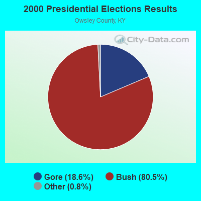


Graphs represent county-level data. Detailed 2008 Election Results
Religion statistics for Sturgeon, KY (based on Owsley County data)
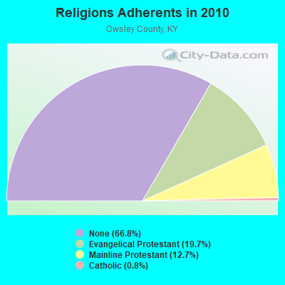
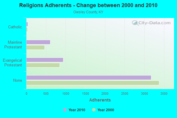
| Religion | Adherents | Congregations |
|---|---|---|
| Evangelical Protestant | 939 | 11 |
| Mainline Protestant | 605 | 5 |
| Catholic | 37 | 1 |
| None | 3,174 | - |
Food Environment Statistics:
| Here: | 4.35 / 10,000 pop. |
| Kentucky: | 2.19 / 10,000 pop. |
| Owsley County: | 4.35 / 10,000 pop. |
| Kentucky: | 4.36 / 10,000 pop. |
| Here: | 2.17 / 10,000 pop. |
| Kentucky: | 5.74 / 10,000 pop. |
| This county: | 11.9% |
| State: | 11.0% |
| This county: | 30.1% |
| Kentucky: | 30.0% |
| This county: | 25.4% |
| Kentucky: | 15.9% |
Strongest AM radio stations in Sturgeon:
- WMTC (730 AM; 5 kW; VANCLEVE, KY; Owner: THE KENTUCKY MOUNTAIN HOLINESS ASSN.)
- WEKG (810 AM; daytime; 5 kW; JACKSON, KY; Owner: INTERMOUNTAIN B/CING CO., INC.)
- WKLB (1290 AM; 5 kW; MANCHESTER, KY; Owner: BARKER BROADCASTING COMPANY, INC.)
- WKVL (850 AM; daytime; 50 kW; KNOXVILLE, TN; Owner: HORNE RADIO, LLC)
- WHAS (840 AM; 50 kW; LOUISVILLE, KY; Owner: CLEAR CHANNEL BROADCASTING LICENSES, INC.)
- WLW (700 AM; 50 kW; CINCINNATI, OH; Owner: JACOR BROADCASTING CORPORATION)
- WKIC (1390 AM; 5 kW; HAZARD, KY)
- WTVN (610 AM; 50 kW; COLUMBUS, OH; Owner: CITICASTERS LICENSES, L.P.)
- WKDP (1330 AM; 5 kW; CORBIN, KY; Owner: EUBANKS BROADCASTING, INC.)
- WFSR (970 AM; 5 kW; HARLAN, KY; Owner: EASTERN BROADCASTING COMPAY)
- WEKC (710 AM; daytime; 4 kW; WILLIAMSBURG, KY; Owner: GERALD PARKS)
- WFGW (1010 AM; 50 kW; BLACK MOUNTAIN, NC; Owner: BLUE RIDGE BROADCASTING CORP.)
- WSAI (1530 AM; 50 kW; CINCINNATI, OH; Owner: JACOR BROADCASTING CORPORATION)
Strongest FM radio stations in Sturgeon:
- WWAG (107.9 FM; MCKEE, KY; Owner: DANDY BROADCASTING, INC.)
- WTBK (105.7 FM; MANCHESTER, KY; Owner: MANCHESTER COMMUNICATIONS, INC.)
- WLJC (102.1 FM; BEATTYVILLE, KY; Owner: HOUR OF HARVEST, INCORPORATED)
- WOCS (88.3 FM; LEROSE, KY; Owner: BOARD OF REGENTS - MOREHEAD STATE UNIVERSITY)
- WJSN-FM (106.5 FM; JACKSON, KY; Owner: INTERMOUNTAIN BROADCASTING CO.)
- WSGS (101.1 FM; HAZARD, KY; Owner: MOUNTAIN BROADCASTING SERVICE, INC.)
- WZQQ (97.9 FM; HYDEN, KY; Owner: LESLIE COUNTY BROADCASTING, INC.)
- WJMD (104.7 FM; HAZARD, KY; Owner: HAZARD BROADCASTING SERVICES)
- WSKV-FM (104.9 FM; STANTON, KY; Owner: PARKS BROADCASTING, INC.)
- WSEH (102.7 FM; CUMBERLAND, KY; Owner: CUMBERLAND CITY BROADCASTING, INC.)
- WEKH (90.9 FM; HAZARD, KY; Owner: EASTERN KENTUCKY UNIVERSITY)
- WCYO (100.7 FM; IRVINE, KY; Owner: KENTUCKY RIVER BROADCASTING CO.)
- WYGE (92.3 FM; LONDON, KY; Owner: ETHEL HUFF BROADCASTING, LLC)
- WWLT (103.1 FM; MANCHESTER, KY; Owner: VERNON R. BALDWIN, INC.)
- WLFX (106.7 FM; BEREA, KY; Owner: WALLINGFORD COMMUNICATIONS, LLC)
- WTUK (105.1 FM; HARLAN, KY; Owner: EASTERN BROADCASTING COMPANY)
- WKDP-FM (99.5 FM; CORBIN, KY; Owner: EUBANKS BROADCASTING, INC.)
- WCBJ (103.7 FM; CAMPTON, KY; Owner: MORGAN COUNTY INDUSTRIES INC)
- WMTC-FM (99.9 FM; VANCLEVE, KY; Owner: KENTUCKY MOUNTAIN HOLINESS ASSOC.)
- WWEL (103.9 FM; LONDON, KY; Owner: F.T.G. BROADCASTING, INC.)
TV broadcast stations around Sturgeon:
- WLJC-TV (Channel 65; BEATTYVILLE, KY; Owner: HOUR OF HARVEST, INC.)
- W26BK (Channel 26; TALBERT, KY; Owner: MS COMMUNICATIONS, LLC)
- W16BI (Channel 16; TALBERT, KY; Owner: MS COMMUNICATIONS, LLC)
- WUPX-TV (Channel 67; MOREHEAD, KY; Owner: PAXSON LEXINGTON LICENSE, INC.)
- W64CM (Channel 64; TALBERT, KY; Owner: MS COMMUNICATIONS, LLC)
- W66DA (Channel 66; TALBERT, KY; Owner: MS COMMUNICATIONS, LLC)
- WYMT-TV (Channel 57; HAZARD, KY; Owner: WYMT LICENSEE CORP.)
- W24BT (Channel 24; TALBERT, KY; Owner: MS COMMUNICATIONS, LLC)
- WLEX-TV (Channel 18; LEXINGTON, KY; Owner: WLEX COMMUNICATIONS, L.L.C.)
- W54CI (Channel 54; TALBERT, KY; Owner: MS COMMUNICATIONS, LLC)
- WBLU-LP (Channel 62; LEXINGTON, KY; Owner: SANDRA B. POWLEY)

- 38.5%Electricity
- 31.1%Bottled, tank, or LP gas
- 19.3%Wood
- 6.2%Coal or coke
- 3.1%Utility gas
- 1.9%Other fuel

- 28.7%Electricity
- 23.4%Bottled, tank, or LP gas
- 22.3%Wood
- 10.6%Coal or coke
- 8.5%Fuel oil, kerosene, etc.
- 6.4%Utility gas
Sturgeon compared to Kentucky state average:
- Median household income below state average.
- Median house value significantly below state average.
- Unemployed percentage below state average.
- Black race population percentage significantly below state average.
- Hispanic race population percentage significantly below state average.
- Foreign-born population percentage significantly below state average.
- Length of stay since moving in significantly above state average.
- Number of rooms per house significantly below state average.
- House age significantly below state average.
- Institutionalized population percentage above state average.
- Number of college students significantly below state average.
- Percentage of population with a bachelor's degree or higher significantly below state average.