South Garfield, Montana
Submit your own pictures of this place and show them to the world
- OSM Map
- General Map
- Google Map
- MSN Map

| Males: 188 | |
| Females: 153 |
| Median resident age: | 40.5 years |
| Montana median age: | 37.5 years |
Zip code: 59322
| South Garfield: | $72,911 |
| MT: | $67,631 |
Estimated per capita income in 2022: $29,207 (it was $11,902 in 2000)
South Garfield CCD income, earnings, and wages data
Estimated median house or condo value in 2022: $447,318 (it was $110,900 in 2000)
| South Garfield: | $447,318 |
| MT: | $366,400 |
Mean prices in 2022: all housing units: $340,621; detached houses: $382,342; mobile homes: $146,489
South Garfield, MT residents, houses, and apartments details
Detailed information about poverty and poor residents in South Garfield, MT


- 35798.3%White alone
- 51.4%American Indian alone
- 10.3%Asian alone

Races in South Garfield detailed stats: ancestries, foreign born residents, place of birth
 Recent articles from our blog. Our writers, many of them Ph.D. graduates or candidates, create easy-to-read articles on a wide variety of topics.
Current Local Time: MST time zone
Land area: 2139.8 square miles.
Population density: 0.2 people per square mile (very low).

| South Garfield CCD: | 0.3% ($375) |
| Montana: | 1.3% ($1,212) |
Nearest city with pop. 50,000+: Billings, MT  (118.4 miles , pop. 89,847).
Nearest city with pop. 200,000+: West Adams, CO (505.6 miles , pop. 259,628).
Nearest city with pop. 1,000,000+: Phoenix, AZ (974.6 miles , pop. 1,321,045).
Nearest cities:
), ), ), ), )Latitude: 47.06 N, Longitude: 106.87 W
Area code commonly used in this area: 406


| Here: | 5.6% |
| Montana: | 3.8% |

- Agriculture, forestry, fishing & hunting (70.9%)
- Public administration (5.3%)
- U. S. Postal service (4.8%)
- Educational services (4.2%)
- Accommodation & food services (3.7%)
- Health care (2.1%)
- Mining, quarrying, oil & gas extraction (1.6%)

- Agriculture, forestry, fishing & hunting (86.1%)
- Public administration (5.2%)
- Mining, quarrying, oil & gas extraction (2.6%)
- Educational services (2.6%)
- U. S. Postal service (1.7%)
- Health care (1.7%)

- Agriculture, forestry, fishing & hunting (47.3%)
- U. S. Postal service (9.5%)
- Accommodation & food services (9.5%)
- Educational services (6.8%)
- Public administration (5.4%)
- Food & beverage stores (4.1%)
- Professional, scientific, technical services (4.1%)

- Farmers and farm managers (59.8%)
- Agricultural workers, including supervisors (11.1%)
- Preschool, kindergarten, elementary, and middle school teachers (3.2%)
- Material recording, scheduling, dispatching, and distributing workers (2.6%)
- Information and record clerks, except customer service representatives (2.1%)
- Other management occupations, except farmers and farm managers (2.1%)
- Food and beverage serving workers, except waiters and waitresses (2.1%)

- Farmers and farm managers (69.6%)
- Agricultural workers, including supervisors (16.5%)
- Preschool, kindergarten, elementary, and middle school teachers (2.6%)
- Other office and administrative support workers, including supervisors (2.6%)
- Other material moving workers, except laborers (2.6%)
- Driver/sales workers and truck drivers (2.6%)
- Other management occupations, except farmers and farm managers (1.7%)

- Farmers and farm managers (44.6%)
- Material recording, scheduling, dispatching, and distributing workers (6.8%)
- Information and record clerks, except customer service representatives (5.4%)
- Food and beverage serving workers, except waiters and waitresses (5.4%)
- Cashiers (5.4%)
- Preschool, kindergarten, elementary, and middle school teachers (4.1%)
- Other food preparation and serving workers, including supervisors (4.1%)
Average climate in South Garfield, Montana
Based on data reported by over 4,000 weather stations


Earthquake activity:
South Garfield-area historical earthquake activity is significantly above Montana state average. It is 373% greater than the overall U.S. average.On 8/18/1959 at 06:37:13, a magnitude 7.7 (7.7 UK, Class: Major, Intensity: VIII - XII) earthquake occurred 250.8 miles away from South Garfield center, causing $26,000,000 total damage
On 10/28/1983 at 14:06:06, a magnitude 7.3 (6.2 MB, 7.3 MS, 7.0 MW) earthquake occurred 393.6 miles away from South Garfield center, causing 2 deaths (2 shaking deaths) and 3 injuries, causing $15,000,000 total damage
On 6/30/1975 at 18:54:13, a magnitude 6.1 (5.6 MB, 5.9 MS, 6.1 UK, 6.1 ML, Class: Strong, Intensity: VII - IX) earthquake occurred 248.6 miles away from South Garfield center
On 7/6/2017 at 06:30:17, a magnitude 5.8 (5.8 MW, Depth: 7.6 mi, Class: Moderate, Intensity: VI - VII) earthquake occurred 269.4 miles away from South Garfield center
On 3/31/2020 at 23:52:30, a magnitude 6.5 (6.5 MW, Depth: 7.5 mi) earthquake occurred 436.1 miles away from the city center
On 7/26/2005 at 04:08:37, a magnitude 5.7 (5.7 MB, 5.2 MS, 5.6 MW) earthquake occurred 295.9 miles away from South Garfield center
Magnitude types: body-wave magnitude (MB), local magnitude (ML), surface-wave magnitude (MS), moment magnitude (MW)
Natural disasters:
The number of natural disasters in Garfield County (6) is a lot smaller than the US average (15).Major Disasters (Presidential) Declared: 4
Emergencies Declared: 1
Causes of natural disasters: Floods: 3, Storms: 2, Fire: 1, Hurricane: 1, Other: 1 (Note: some incidents may be assigned to more than one category).
Colleges/universities with over 2000 students nearest to South Garfield:
- Montana State University-Billings (about 118 miles; Billings, MT; Full-time enrollment: 4,319)
- Sheridan College (about 159 miles; Sheridan, WY; FT enrollment: 2,070)
- Montana State University (about 222 miles; Bozeman, MT; FT enrollment: 12,942)
- Black Hills State University (about 229 miles; Spearfish, SD; FT enrollment: 3,166)
- South Dakota School of Mines and Technology (about 273 miles; Rapid City, SD; FT enrollment: 2,102)
- Minot State University (about 273 miles; Minot, ND; FT enrollment: 2,887)
- Bismarck State College (about 287 miles; Bismarck, ND; FT enrollment: 3,015)
Points of interest:
Notable locations in South Garfield: Mincoff Ranch (A), Mahoney Ranch (B), Brown Ranch (C), Flowing Well (D), Dutton Ranch (E), Hill Ranch (F), Whiteside Ranch (G), Kirby Ranch (H), Kramer Ranch (I), Flowing Wells Rest Area (J), Stebbins Windmill (K), Rimrock Ranch (L). Display/hide their locations on the map
Church in South Garfield: Neudorfer Church (A). Display/hide its location on the map
Cemetery: Cohagen Cemetery (1). Display/hide its location on the map
Reservoirs: Birkrem Reservoir (A), Antone Reservoir (B), McWilliams Reservoir (C), Shaw Reservoir (D), Section Four Reservoir (E), Guesanborn Reservoir (F), Fourteen Reservoir (G), Old Lake (H). Display/hide their locations on the map
Streams, rivers, and creeks: Ada Creek (A), Ash Creek (B), Badger Creek (C), Basin Creek (D), Christenson Creek (E), Coal Creek (F), Tree Creek (G), Cottonwood Creek (H), Crow Rock Creek (I). Display/hide their locations on the map
Park in South Garfield: Dinosaurs Historical Marker (1). Display/hide its location on the map
| This place: | 2.4 people |
| Montana: | 2.4 people |
| This place: | 71.3% |
| Whole state: | 62.8% |
| This place: | 6.6% |
| Whole state: | 6.7% |
Likely homosexual households (counted as self-reported same-sex unmarried-partner households)
- Lesbian couples: 2.5% of all households
- Gay men: 0.0% of all households
| This place: | 13.9% |
| Whole state: | 14.6% |
| This place: | 9.4% |
| Whole state: | 5.8% |
For population 15 years and over in South Garfield:

- Never married: 17.1%
- Now married: 75.4%
- Separated: 0.0%
- Widowed: 3.6%
- Divorced: 4.0%
For population 25 years and over in South Garfield:
- High school or higher: 90.3%
- Bachelor's degree or higher: 19.4%
- Graduate or professional degree: 1.4%
- Unemployed: 2.6%
- Mean travel time to work (commute): 11.8 minutes


| Here: | 7.8 |
| Montana average: | 10.4 |
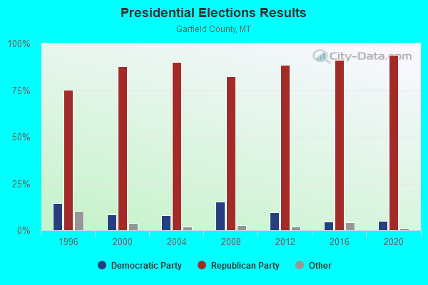
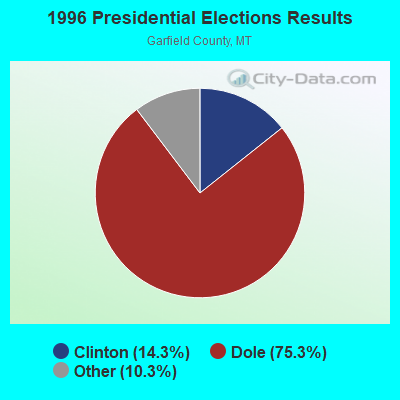
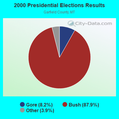


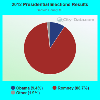
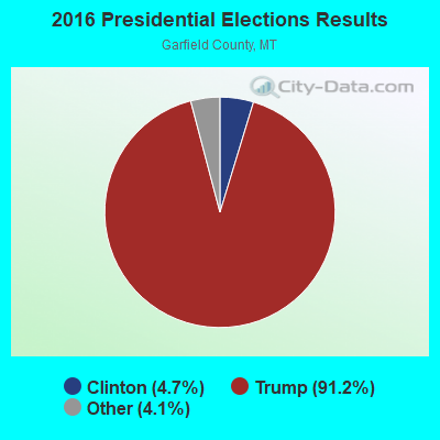
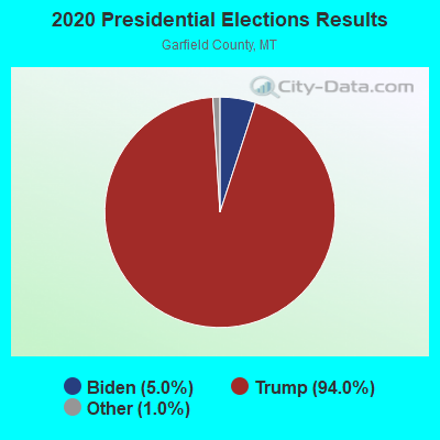
Graphs represent county-level data. Detailed 2008 Election Results
Religion statistics for South Garfield, MT (based on Garfield County data)
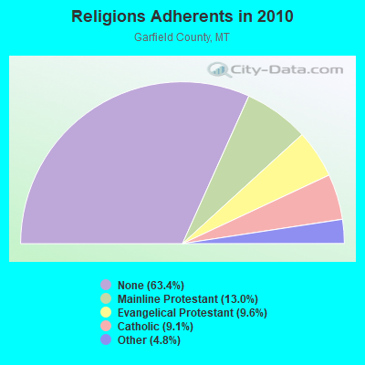
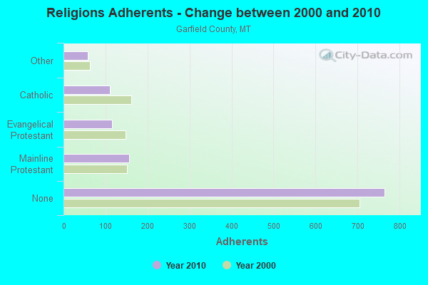
| Religion | Adherents | Congregations |
|---|---|---|
| Mainline Protestant | 157 | 2 |
| Evangelical Protestant | 116 | 4 |
| Catholic | 110 | 1 |
| Other | 58 | 1 |
| None | 765 | - |
Food Environment Statistics:
| Garfield County: | 8.30 / 10,000 pop. |
| State: | 2.55 / 10,000 pop. |
| Garfield County: | 16.60 / 10,000 pop. |
| Montana: | 4.69 / 10,000 pop. |
| Garfield County: | 16.60 / 10,000 pop. |
| Montana: | 10.38 / 10,000 pop. |
| Garfield County: | 8.2% |
| State: | 7.2% |
| Garfield County: | 25.5% |
| Montana: | 23.1% |
Strongest AM radio stations in South Garfield:
- KATL (770 AM; 10 kW; MILES CITY, MT; Owner: STAR PRINTING COMPANY)
- KMTA (1050 AM; 10 kW; MILES CITY, MT; Owner: SENGER BROADCASTING CORPORATION)
- KIKC (1250 AM; 5 kW; FORSYTH, MT; Owner: MILES CITY, FORSYTH B/DCSTG, INC.)
- KXMR (710 AM; 50 kW; BISMARCK, ND; Owner: RADIO BISMARCK MANDAN, LLC)
- KTWO (1030 AM; 50 kW; CASPER, WY; Owner: CITICASTERS LICENSES, L.P.)
- KERR (750 AM; 50 kW; POLSON, MT; Owner: ANDERSON RADIO BROADCASTING, INC.)
- KBHB (810 AM; 25 kW; STURGIS, SD; Owner: MONTEREY LICENSES, LLC)
- KURL (730 AM; 5 kW; BILLINGS, MT; Owner: ELENBAAS MEDIA, INC.)
- KGHL (790 AM; 5 kW; BILLINGS, MT; Owner: NEW NORTHWEST BROADCASTERS, LLC)
- KBUL (970 AM; 5 kW; BILLINGS, MT; Owner: CAPSTAR TX LIMITED PARTNERSHIP)
- KUYO (830 AM; daytime; 25 kW; EVANSVILLE, WY; Owner: WYOMING CHRISTIAN BROADCASTING COMPANY)
- KOFI (1180 AM; 50 kW; KALISPELL, MT; Owner: KOFI, INC.)
- KFLN (960 AM; 5 kW; BAKER, MT; Owner: NEWELL BROADCASTING INC.)

- 50.6%Bottled, tank, or LP gas
- 26.6%Electricity
- 15.2%Wood
- 3.8%Utility gas
- 3.8%Fuel oil, kerosene, etc.

- 78.9%Bottled, tank, or LP gas
- 15.8%Wood
- 5.3%Coal or coke
South Garfield compared to Montana state average:
- Unemployed percentage significantly below state average.
- Black race population percentage significantly below state average.
- Hispanic race population percentage significantly below state average.
- Foreign-born population percentage significantly below state average.
- Renting percentage below state average.
- Length of stay since moving in significantly above state average.
- Number of rooms per house significantly below state average.
- House age significantly below state average.
- Number of college students significantly below state average.
South Garfield on our top lists:
- #43 on the list of "Top 100 cities with largest land areas"
- #27 on the list of "Top 101 counties with highest percentage of residents voting for Romney (Republican) in the 2012 Presidential Election"
- #27 on the list of "Top 101 counties with the lowest total withdrawal of fresh water for public supply"
- #38 on the list of "Top 101 counties with the largest number of people without health insurance coverage in 2000"
- #82 on the list of "Top 101 counties with the lowest ground withdrawal of fresh water for public supply"