North Garfield, Montana
Submit your own pictures of this place and show them to the world
- OSM Map
- General Map
- Google Map
- MSN Map

| Males: 431 | |
| Females: 431 |
| Median resident age: | 41.8 years |
| Montana median age: | 37.5 years |
Zip code: 59337
| North Garfield: | $56,455 |
| MT: | $67,631 |
Estimated per capita income in 2022: $35,916 (it was $14,636 in 2000)
North Garfield CCD income, earnings, and wages data
Estimated median house or condo value in 2022: $169,408 (it was $42,000 in 2000)
| North Garfield: | $169,408 |
| MT: | $366,400 |
Mean prices in 2022: all housing units: $340,621; detached houses: $382,342; mobile homes: $146,489
North Garfield, MT residents, houses, and apartments details
Detailed information about poverty and poor residents in North Garfield, MT
Compare current foreclosures near your location:
| Photo | Address | Area | Beds / Baths | Price | Details |
|---|---|---|---|---|---|

|
#1
N Rhodes St
Pretty Prairie, KS 67570
|
1,725 sq. feet
|
2 baths 4 beds |
show details | |

|
#2
W 21st St N
Cheney, KS 67025
|
3,190 sq. feet
|
3 baths 5 beds |
show details | |

|
#3
NE Waterloo Ave
Murdock, KS 67111
|
1,220 sq. feet
|
1 baths 3 beds |
show details | |

|
#4
E Arlington Rd
Haven, KS 67543
|
960 sq. feet
|
1 baths 2 beds |
show details | |

|
#5
E Winterset St
Goddard, KS 67052
|
816 sq. feet
|
1 baths 2 beds |
show details | |

|
#6
W 39th St S
Goddard, KS 67052
|
4,221 sq. feet
|
3 baths 3 beds |
show details | |

|
#7
E 4th Ave Apt 1
Cheney, KS 67025
|
- sq. feet
|
- baths - beds |
show details | |

|
#8
SE Viney Ave
Murdock, KS 67111
|
- sq. feet
|
- baths - beds |
show details | |

|
#9
W Main St
Mount Hope, KS 67108
|
- sq. feet
|
- baths - beds |
show details | |

|
#10
N 189th Cir W
Colwich, KS 67030
|
- sq. feet
|
- baths - beds |
show details |
| Photo | Address | Area | Beds / Baths | Price | Details |
|---|---|---|---|---|---|

|
#11
N Main St
Goddard, KS 67052
|
- sq. feet
|
- baths - beds |
show details | |

|
#12
Martens Ct
Goddard, KS 67052
|
- sq. feet
|
- baths - beds |
show details | |

|
#13
W Maple St Lot D
Goddard, KS 67052
|
- sq. feet
|
- baths - beds |
show details | |

|
#14
S 339th St W
Cheney, KS 67025
|
- sq. feet
|
- baths - beds |
show details | |

|
#15
E Casey Dr
Goddard, KS 67052
|
- sq. feet
|
- baths - beds |
show details | |

|
Check over 1 million property listings on Foreclosure.com!
|
browse all offers | |||

- 90799.0%White alone
- 50.5%Hispanic
- 30.3%Two or more races
- 10.1%Black alone

Races in North Garfield detailed stats: ancestries, foreign born residents, place of birth
 Recent articles from our blog. Our writers, many of them Ph.D. graduates or candidates, create easy-to-read articles on a wide variety of topics.
Current Local Time: MST time zone
Land area: 2528.3 square miles.
Population density: 0.3 people per square mile (very low).

| North Garfield CCD: | 0.9% ($368) |
| Montana: | 1.3% ($1,212) |
Nearest city with pop. 50,000+: Billings, MT  (130.9 miles , pop. 89,847).
Nearest city with pop. 200,000+: West Adams, CO (532.2 miles , pop. 259,628).
Nearest city with pop. 1,000,000+: Phoenix, AZ (994.5 miles , pop. 1,321,045).
Nearest cities:
), ), ), ), Latitude: 47.41 N, Longitude: 107.13 W
Area code commonly used in this area: 406


| Here: | 5.6% |
| Montana: | 3.8% |

- Agriculture, forestry, fishing & hunting (31.6%)
- Public administration (10.1%)
- Educational services (8.8%)
- Construction (7.1%)
- Health care (6.9%)
- Accommodation & food services (4.1%)
- Social assistance (3.9%)

- Agriculture, forestry, fishing & hunting (42.4%)
- Construction (12.2%)
- Public administration (9.6%)
- Truck transportation (5.9%)
- Gasoline stations (3.7%)
- Educational services (3.7%)
- Broadcasting & telecommunications (2.6%)

- Agriculture, forestry, fishing & hunting (16.5%)
- Educational services (16.0%)
- Health care (14.9%)
- Public administration (10.8%)
- Social assistance (9.3%)
- Accommodation & food services (8.2%)
- Finance & insurance (5.2%)

- Farmers and farm managers (21.1%)
- Agricultural workers, including supervisors (7.7%)
- Building and grounds cleaning and maintenance occupations (4.9%)
- Driver/sales workers and truck drivers (4.5%)
- Preschool, kindergarten, elementary, and middle school teachers (4.1%)
- Carpenters (3.2%)
- Other management occupations, except farmers and farm managers (2.8%)

- Farmers and farm managers (30.3%)
- Agricultural workers, including supervisors (10.0%)
- Driver/sales workers and truck drivers (7.0%)
- Carpenters (5.5%)
- Building and grounds cleaning and maintenance occupations (4.1%)
- Vehicle and mobile equipment mechanics, installers, and repairers (4.1%)
- Electrical equipment mechanics and other installation, maintenance, and repair workers, including supervisors (3.7%)

- Preschool, kindergarten, elementary, and middle school teachers (8.2%)
- Farmers and farm managers (8.2%)
- Building and grounds cleaning and maintenance occupations (6.2%)
- Bookkeeping, accounting, and auditing clerks (5.7%)
- Other management occupations, except farmers and farm managers (5.2%)
- Agricultural workers, including supervisors (4.6%)
- Cooks and food preparation workers (4.1%)
Average climate in North Garfield, Montana
Based on data reported by over 4,000 weather stations


Earthquake activity:
North Garfield-area historical earthquake activity is significantly above Montana state average. It is 364% greater than the overall U.S. average.On 8/18/1959 at 06:37:13, a magnitude 7.7 (7.7 UK, Class: Major, Intensity: VIII - XII) earthquake occurred 259.7 miles away from the city center, causing $26,000,000 total damage
On 10/28/1983 at 14:06:06, a magnitude 7.3 (6.2 MB, 7.3 MS, 7.0 MW) earthquake occurred 396.0 miles away from North Garfield center, causing 2 deaths (2 shaking deaths) and 3 injuries, causing $15,000,000 total damage
On 6/30/1975 at 18:54:13, a magnitude 6.1 (5.6 MB, 5.9 MS, 6.1 UK, 6.1 ML, Class: Strong, Intensity: VII - IX) earthquake occurred 256.7 miles away from the city center
On 7/6/2017 at 06:30:17, a magnitude 5.8 (5.8 MW, Depth: 7.6 mi, Class: Moderate, Intensity: VI - VII) earthquake occurred 258.7 miles away from the city center
On 3/31/2020 at 23:52:30, a magnitude 6.5 (6.5 MW, Depth: 7.5 mi) earthquake occurred 434.7 miles away from North Garfield center
On 7/26/2005 at 04:08:37, a magnitude 5.7 (5.7 MB, 5.2 MS, 5.6 MW) earthquake occurred 294.6 miles away from North Garfield center
Magnitude types: body-wave magnitude (MB), local magnitude (ML), surface-wave magnitude (MS), moment magnitude (MW)
Natural disasters:
The number of natural disasters in Garfield County (6) is a lot smaller than the US average (15).Major Disasters (Presidential) Declared: 4
Emergencies Declared: 1
Causes of natural disasters: Floods: 3, Storms: 2, Fire: 1, Hurricane: 1, Other: 1 (Note: some incidents may be assigned to more than one category).
Colleges/universities with over 2000 students nearest to North Garfield:
- Montana State University-Billings (about 130 miles; Billings, MT; Full-time enrollment: 4,319)
- Sheridan College (about 184 miles; Sheridan, WY; FT enrollment: 2,070)
- Montana State University (about 223 miles; Bozeman, MT; FT enrollment: 12,942)
- Black Hills State University (about 256 miles; Spearfish, SD; FT enrollment: 3,166)
- Minot State University (about 277 miles; Minot, ND; FT enrollment: 2,887)
- South Dakota School of Mines and Technology (about 299 miles; Rapid City, SD; FT enrollment: 2,102)
- Bismarck State College (about 300 miles; Bismarck, ND; FT enrollment: 3,015)
Points of interest:
Notable locations in North Garfield: Matovich Ranch (A), Binion Ranch (B), Burgess Ranch (C), Cole Ranch (D), Devils Creek Campground (E), Flint Ranch (F), Wilson Ranch (G), Kamp Katie (H), Jordan Mobile Home Park (I), Garfield County Fairground (J), Fairview Hall (K), Rock Creek Fishing Access Site (L), Twitchell Ranch (M), Freemen Ranch (N), Trumbo Ranch (O), Thomas Ranch (P), Seven W Ranch (Q), Peterson Ranch (R), O'Connor Ranch (S), Moss Ranch (T). Display/hide their locations on the map
Churches in North Garfield include: Brusett Community Church (A), Blackfoot Church (B), The Church of Jesus Christ of Latter Day Saints (C), Saint Johns Evangelical Lutheran Church (D), Community Presbyterian Church (E), Jordan Seventh Day Adventist Church (F), Saint John the Baptist Church (G), Assembly of God Church (H). Display/hide their locations on the map
Cemeteries: Coon Cemetery (1), Greenridge Cemetery (2), Pioneer Cemetery (3), Steve Forks Cemetery (4), The Zions Lutheran Cemetery (5), Wolf Cemetery (6), Butte Creek Cemetery (7). Display/hide their locations on the map
Reservoirs: Burgess Reservoir (A), Stroud Reservoir (B), Wheatcroft Reservoir (C), Gumbo Reservoir (D), Fork Reservoir (E), Fisher Reservoir (F), Ezwkial Number One Reservoir (G), Ezekial Reservoir (H). Display/hide their locations on the map
Streams, rivers, and creeks: Woody Creek (A), Moonlight Creek (B), Butts Coulee (C), Ash Creek (D), Bear Creek (E), Big Coulee Creek (F), Billy Creek (G), Blood Creek (H), Calf Creek (I). Display/hide their locations on the map
Parks in North Garfield include: Woodland Park (1), Rock Creek State Park (2), Panwitz Park (3), Hell Creek Recreation Area (4), Willems Park (5), Kariotis Park (6), Hell Creek State Park (7), Indian Country Historical Marker (8), Devils Creek State Recreation Area (9). Display/hide their locations on the map
| This place: | 2.2 people |
| Montana: | 2.4 people |
| This place: | 63.4% |
| Whole state: | 62.8% |
| This place: | 3.9% |
| Whole state: | 6.7% |
No gay or lesbian households reported
| This place: | 24.1% |
| Whole state: | 14.6% |
| This place: | 8.0% |
| Whole state: | 5.8% |
For population 15 years and over in North Garfield:

- Never married: 19.0%
- Now married: 65.6%
- Separated: 0.9%
- Widowed: 9.4%
- Divorced: 6.0%
For population 25 years and over in North Garfield:
- High school or higher: 82.9%
- Bachelor's degree or higher: 15.9%
- Graduate or professional degree: 2.3%
- Unemployed: 3.3%
- Mean travel time to work (commute): 11.2 minutes


| Here: | 9.4 |
| Montana average: | 10.4 |
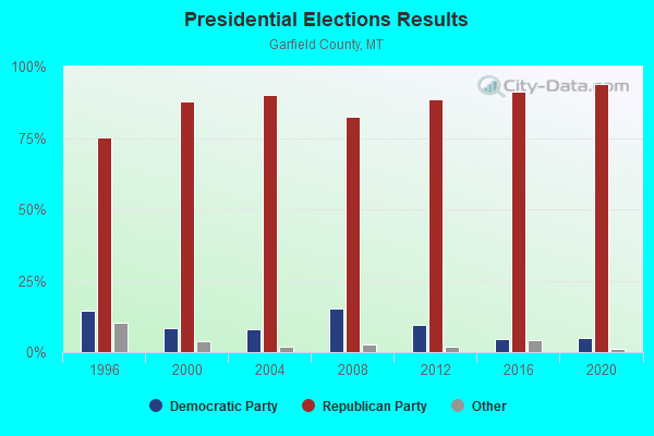
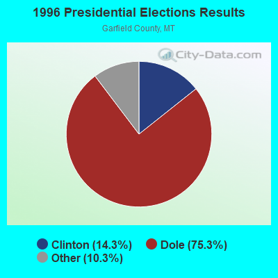
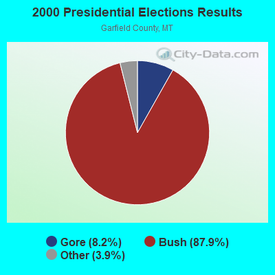


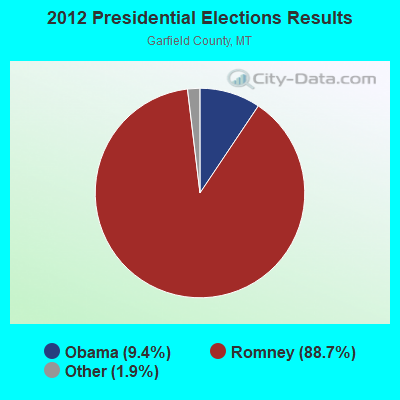
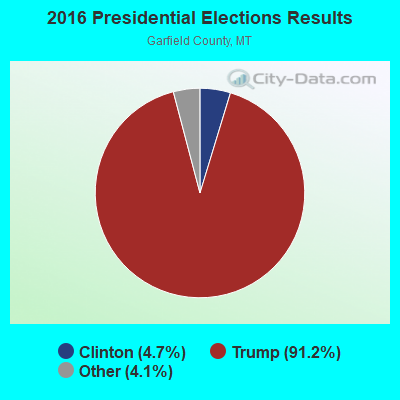
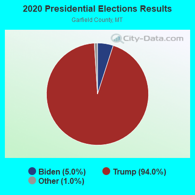
Graphs represent county-level data. Detailed 2008 Election Results
Religion statistics for North Garfield, MT (based on Garfield County data)
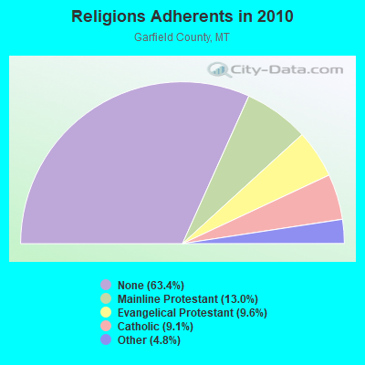
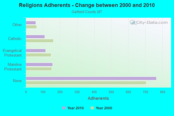
| Religion | Adherents | Congregations |
|---|---|---|
| Mainline Protestant | 157 | 2 |
| Evangelical Protestant | 116 | 4 |
| Catholic | 110 | 1 |
| Other | 58 | 1 |
| None | 765 | - |
Food Environment Statistics:
| Garfield County: | 8.30 / 10,000 pop. |
| State: | 2.55 / 10,000 pop. |
| Garfield County: | 16.60 / 10,000 pop. |
| State: | 4.69 / 10,000 pop. |
| Garfield County: | 16.60 / 10,000 pop. |
| Montana: | 10.38 / 10,000 pop. |
| Here: | 8.2% |
| Montana: | 7.2% |
| Garfield County: | 25.5% |
| Montana: | 23.1% |
Strongest AM radio stations in North Garfield:
- KATL (770 AM; 10 kW; MILES CITY, MT; Owner: STAR PRINTING COMPANY)
- KMTA (1050 AM; 10 kW; MILES CITY, MT; Owner: SENGER BROADCASTING CORPORATION)
- KXMR (710 AM; 50 kW; BISMARCK, ND; Owner: RADIO BISMARCK MANDAN, LLC)
- KERR (750 AM; 50 kW; POLSON, MT; Owner: ANDERSON RADIO BROADCASTING, INC.)
- KIKC (1250 AM; 5 kW; FORSYTH, MT; Owner: MILES CITY, FORSYTH B/DCSTG, INC.)
- KTWO (1030 AM; 50 kW; CASPER, WY; Owner: CITICASTERS LICENSES, L.P.)
- KBHB (810 AM; 25 kW; STURGIS, SD; Owner: MONTEREY LICENSES, LLC)
- KOFI (1180 AM; 50 kW; KALISPELL, MT; Owner: KOFI, INC.)
- KURL (730 AM; 5 kW; BILLINGS, MT; Owner: ELENBAAS MEDIA, INC.)
- KGHL (790 AM; 5 kW; BILLINGS, MT; Owner: NEW NORTHWEST BROADCASTERS, LLC)
- KUYO (830 AM; daytime; 25 kW; EVANSVILLE, WY; Owner: WYOMING CHRISTIAN BROADCASTING COMPANY)
- KGVW (640 AM; 10 kW; BELGRADE, MT; Owner: GALLATIN VALLEY WITNESS, INC.)
- KBUL (970 AM; 5 kW; BILLINGS, MT; Owner: CAPSTAR TX LIMITED PARTNERSHIP)
TV broadcast stations around North Garfield:
- K09HI (Channel 9; JORDAN, ETC., MT; Owner: GARFIELD TV CLUB)
- K11HE (Channel 11; JORDAN, ETC., MT; Owner: GARFIELD TV CLUB)
- K07VA (Channel 7; JORDAN, ETC., MT; Owner: GARFIELD TV CLUB)

- 68.2%Bottled, tank, or LP gas
- 21.5%Electricity
- 4.2%Wood
- 3.2%Coal or coke
- 2.3%Fuel oil, kerosene, etc.
- 0.6%Utility gas

- 77.9%Bottled, tank, or LP gas
- 11.5%Wood
- 6.7%Electricity
- 1.9%Utility gas
- 1.9%Coal or coke
North Garfield compared to Montana state average:
- Median house value below state average.
- Unemployed percentage significantly below state average.
- Black race population percentage below state average.
- Hispanic race population percentage significantly below state average.
- Foreign-born population percentage significantly below state average.
- Length of stay since moving in significantly above state average.
- Number of rooms per house significantly below state average.
- House age significantly below state average.
- Number of college students significantly below state average.
- Percentage of population with a bachelor's degree or higher below state average.
North Garfield on our top lists:
- #34 on the list of "Top 100 cities with largest land areas"
- #27 on the list of "Top 101 counties with highest percentage of residents voting for Romney (Republican) in the 2012 Presidential Election"
- #27 on the list of "Top 101 counties with the lowest total withdrawal of fresh water for public supply"
- #38 on the list of "Top 101 counties with the largest number of people without health insurance coverage in 2000"
- #82 on the list of "Top 101 counties with the lowest ground withdrawal of fresh water for public supply"