Sand Mountain, Georgia
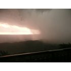
Sand Mountain: Tornado Coming off Sand Mountain, GA
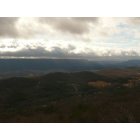
Sand Mountain: View FROM Sand Mountain GA, looking towards Rising Fawn, GA
- add
your
Submit your own pictures of this place and show them to the world
- OSM Map
- General Map
- Google Map
- MSN Map

| Males: 2,137 | |
| Females: 2,223 |
| Median resident age: | 36.6 years |
| Georgia median age: | 33.4 years |
Zip code: 30752
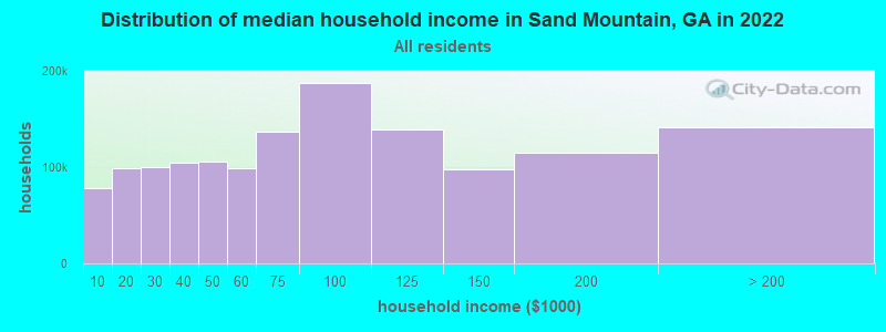
| Sand Mountain: | $50,639 |
| GA: | $72,837 |
Estimated per capita income in 2022: $26,564 (it was $14,042 in 2000)
Sand Mountain CCD income, earnings, and wages data
Estimated median house or condo value in 2022: $167,869 (it was $65,400 in 2000)
| Sand Mountain: | $167,869 |
| GA: | $297,400 |
Detailed information about poverty and poor residents in Sand Mountain, GA
Compare current foreclosures near Sand Mountain, GA:
| Photo | Address | Area | Beds / Baths | Price | Details |
|---|---|---|---|---|---|

|
#1
Sweetens Cove Rd
South Pittsburg, TN 37380
|
1,650 sq. feet
|
2 baths 2 beds |
show details | |

|
#2
James St
Rossville, GA 30741
|
2,255 sq. feet
|
2 baths 3 beds |
show details | |

|
#3
Hass Rd
Jasper, TN 37347
|
1,680 sq. feet
|
2 baths 3 beds |
show details | |

|
#4
W Garden Farm Rd
Rossville, GA 30741
|
1,288 sq. feet
|
1 baths - beds |
show details | |

|
#5
Creek Rd
Wildwood, GA 30757
|
1,560 sq. feet
|
2 baths 3 beds |
show details | |

|
#6
Shellmound Rd
Jasper, TN 37347
|
1,107 sq. feet
|
1 baths - beds |
show details | |

|
#7
Woodland Rd
Flintstone, GA 30725
|
1,116 sq. feet
|
1 baths - beds |
show details | |

|
#8
Nance Dr
Rossville, GA 30741
|
952 sq. feet
|
2 baths - beds |
show details | |

|
#9
Osburn Rd
Chickamauga, GA 30707
|
1,092 sq. feet
|
2 baths - beds |
show details | |

|
#10
Ridgeland Rd
Rossville, GA 30741
|
825 sq. feet
|
1 baths - beds |
show details |
| Photo | Address | Area | Beds / Baths | Price | Details |
|---|---|---|---|---|---|

|
#11
Cubine Rd
Flintstone, GA 30725
|
1,276 sq. feet
|
2 baths - beds |
show details | |

|
#12
E 9th St
Chickamauga, GA 30707
|
1,290 sq. feet
|
4 baths - beds |
show details | |

|
#13
Bolton Rd
Trenton, GA 30752
|
3,760 sq. feet
|
1 baths - beds |
show details | |

|
#14
Newt Johnson Rd
Chickamauga, GA 30707
|
950 sq. feet
|
1 baths - beds |
show details | |

|
#15
Carden Ave
Rossville, GA 30741
|
1,044 sq. feet
|
1 baths - beds |
show details | |

|
#16
Prospect Rd
Chickamauga, GA 30707
|
1,000 sq. feet
|
1 baths - beds |
show details | |

|
#17
Garden St
Rossville, GA 30741
|
888 sq. feet
|
1 baths - beds |
show details | |

|
#18
Lee Ave
Rossville, GA 30741
|
744 sq. feet
|
1 baths - beds |
show details | |

|
#19
Francis Spring Rd
Jasper, TN 37347
|
1,456 sq. feet
|
2 baths - beds |
show details | |

|
#20
Crabtree Rd
Rossville, GA 30741
|
1,570 sq. feet
|
2 baths - beds |
show details |
| Photo | Address | Area | Beds / Baths | Price | Details |
|---|---|---|---|---|---|

|
#21
Nance Dr
Rossville, GA 30741
|
1,296 sq. feet
|
2 baths - beds |
show details | |

|
#22
Highway 11
Rising Fawn, GA 30738
|
960 sq. feet
|
1 baths - beds |
show details | |

|
#23
Sequatchie Mountain Rd
Sequatchie, TN 37374
|
1,068 sq. feet
|
2 baths - beds |
show details | |

|
#24
1st Ave
Jasper, TN 37347
|
1,566 sq. feet
|
1 baths - beds |
show details | |

|
#25
Lofton Ln
Chickamauga, GA 30707
|
1,573 sq. feet
|
1 baths - beds |
show details | |

|
#26
E Oak St
Rossville, GA 30741
|
720 sq. feet
|
1 baths - beds |
show details | |

|
#27
Main St
Jasper, TN 37347
|
1,073 sq. feet
|
1 baths - beds |
show details | |

|
#28
Schmitt Rd
Rossville, GA 30741
|
1,274 sq. feet
|
1 baths - beds |
show details | |

|
#29
N Marble Top Rd
Chickamauga, GA 30707
|
1,540 sq. feet
|
1 baths - beds |
show details | |

|
#30
N Marble Top Rd
Chickamauga, GA 30707
|
1,870 sq. feet
|
2 baths - beds |
show details |
| Photo | Address | Area | Beds / Baths | Price | Details |
|---|---|---|---|---|---|

|
#31
Wilder St
Chickamauga, GA 30707
|
1,272 sq. feet
|
1 baths - beds |
show details | |

|
#32
Ross St
Rossville, GA 30741
|
571 sq. feet
|
1 baths - beds |
show details | |

|
#33
Brenda Ln
Chickamauga, GA 30707
|
1,092 sq. feet
|
1 baths - beds |
show details | |

|
#34
Cate St
Rossville, GA 30741
|
1,152 sq. feet
|
2 baths - beds |
show details | |

|
#35
Road 973
Flat Rock, AL 35966
|
2,076 sq. feet
|
1 baths - beds |
show details | |

|
#36
Riverbend Dr
Jasper, TN 37347
|
2,856 sq. feet
|
2 baths - beds |
show details | |

|
#37
Gold Rd
Jasper, TN 37347
|
1,100 sq. feet
|
1 baths - beds |
show details | |

|
#38
Vineyard Point Rd
Sequatchie, TN 37374
|
1,144 sq. feet
|
1 baths - beds |
show details | |

|
#39
Lisbon Rd
Chickamauga, GA 30707
|
696 sq. feet
|
1 baths - beds |
show details | |

|
#40
N Victor Dr
Flintstone, GA 30725
|
898 sq. feet
|
2 baths - beds |
show details |
| Photo | Address | Area | Beds / Baths | Price | Details |
|---|---|---|---|---|---|

|
#41
Chattanooga Valley Rd
Flintstone, GA 30725
|
1,088 sq. feet
|
2 baths - beds |
show details | |

|
#42
Laurelwood Cir
Rossville, GA 30741
|
1,032 sq. feet
|
1 baths - beds |
show details | |

|
#43
Hulana St
Rossville, GA 30741
|
960 sq. feet
|
1 baths - beds |
show details | |

|
#44
Virginia Ave
Rossville, GA 30741
|
1,254 sq. feet
|
1 baths - beds |
show details | |

|
#45
Mimosa Dr
Chickamauga, GA 30707
|
1,381 sq. feet
|
2 baths - beds |
show details | |

|
#46
Mary St
Rossville, GA 30741
|
1,592 sq. feet
|
2 baths - beds |
show details | |

|
#47
Williams Ln
Rossville, GA 30741
|
1,140 sq. feet
|
1 baths - beds |
show details | |

|
#48
Salem Rd
Rossville, GA 30741
|
1,131 sq. feet
|
1 baths - beds |
show details | |

|
#49
Joyce Ln
Rossville, GA 30741
|
1,080 sq. feet
|
1 baths - beds |
show details | |

|
Check over 1 million property listings on Foreclosure.com!
|
browse all offers | |||

- 3,98997.6%White alone
- 380.9%Two or more races
- 380.9%Hispanic
- 140.3%American Indian alone
- 70.2%Asian alone
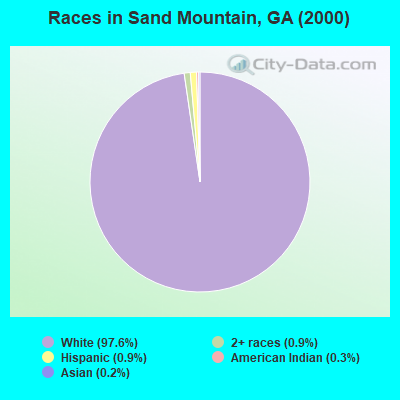
Races in Sand Mountain detailed stats: ancestries, foreign born residents, place of birth
 Recent articles from our blog. Our writers, many of them Ph.D. graduates or candidates, create easy-to-read articles on a wide variety of topics.
Current Local Time: EST time zone
Land area: 39.6 square miles.
Population density: 110 people per square mile (very low).

| Sand Mountain CCD: | 0.7% ($467) |
| Georgia: | 0.9% ($919) |
Nearest city with pop. 50,000+: Chattanooga, TN  (19.1 miles , pop. 155,554).
Nearest city with pop. 200,000+: Atlanta, GA (103.0 miles , pop. 416,474).
Nearest city with pop. 1,000,000+: Chicago, IL (493.4 miles , pop. 2,896,016).
Nearest cities:
), ), ), ), ), Latitude: 34.90 N, Longitude: 85.56 W

| Here: | 2.3% |
| Georgia: | 2.9% |
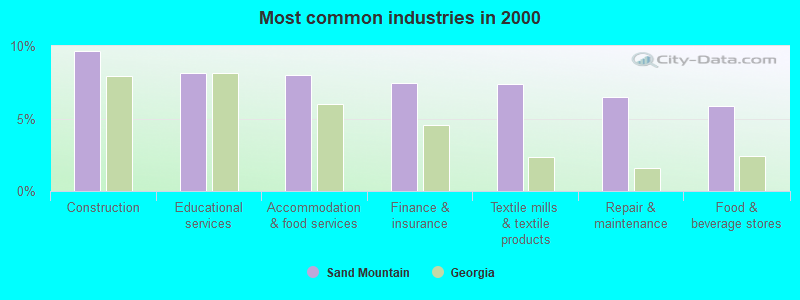
- Construction (9.7%)
- Educational services (8.1%)
- Accommodation & food services (8.0%)
- Finance & insurance (7.5%)
- Textile mills & textile products (7.4%)
- Repair & maintenance (6.5%)
- Food & beverage stores (5.9%)
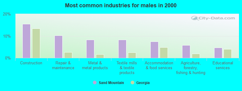
- Construction (15.4%)
- Repair & maintenance (10.3%)
- Metal & metal products (8.3%)
- Textile mills & textile products (8.2%)
- Accommodation & food services (7.5%)
- Agriculture, forestry, fishing & hunting (5.8%)
- Educational services (4.7%)
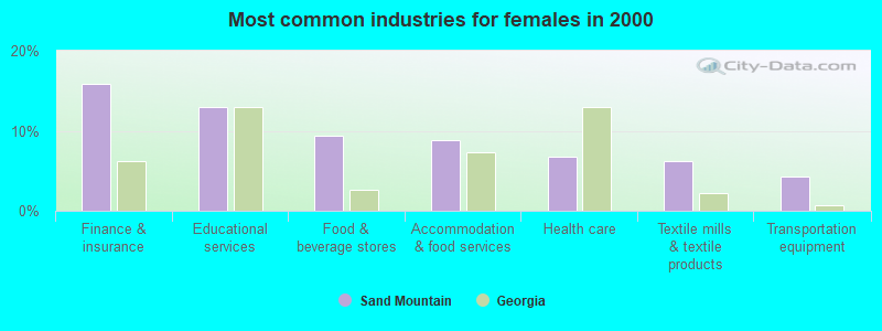
- Finance & insurance (15.8%)
- Educational services (13.0%)
- Food & beverage stores (9.3%)
- Accommodation & food services (8.8%)
- Health care (6.8%)
- Textile mills & textile products (6.2%)
- Transportation equipment (4.3%)
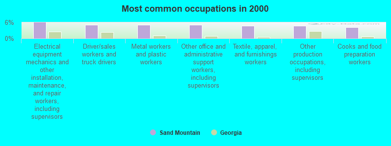
- Electrical equipment mechanics and other installation, maintenance, and repair workers, including supervisors (6.0%)
- Driver/sales workers and truck drivers (5.2%)
- Metal workers and plastic workers (5.2%)
- Other office and administrative support workers, including supervisors (5.1%)
- Textile, apparel, and furnishings workers (4.8%)
- Other production occupations, including supervisors (4.7%)
- Cooks and food preparation workers (4.2%)
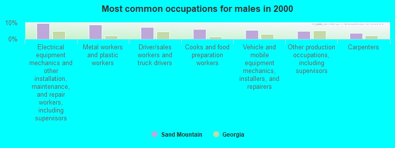
- Electrical equipment mechanics and other installation, maintenance, and repair workers, including supervisors (9.7%)
- Metal workers and plastic workers (8.8%)
- Driver/sales workers and truck drivers (7.3%)
- Cooks and food preparation workers (6.0%)
- Vehicle and mobile equipment mechanics, installers, and repairers (5.5%)
- Other production occupations, including supervisors (5.0%)
- Carpenters (3.6%)

- Other office and administrative support workers, including supervisors (9.6%)
- Textile, apparel, and furnishings workers (6.8%)
- Secretaries and administrative assistants (5.7%)
- Cashiers (5.5%)
- Other sales and related occupations, including supervisors (4.6%)
- Other production occupations, including supervisors (4.3%)
- Preschool, kindergarten, elementary, and middle school teachers (3.5%)
Average climate in Sand Mountain, Georgia
Based on data reported by over 4,000 weather stations


(lower is better)
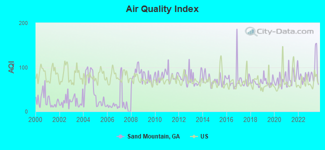
Air Quality Index (AQI) level in 2023 was 94.1. This is worse than average.
| City: | 94.1 |
| U.S.: | 72.6 |
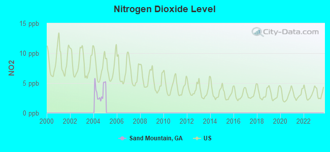
Nitrogen Dioxide (NO2) [ppb] level in 2004 was 3.44. This is significantly better than average. Closest monitor was 9.5 miles away from the city center.
| City: | 3.44 |
| U.S.: | 5.11 |
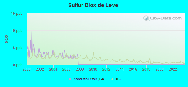
Sulfur Dioxide (SO2) [ppb] level in 2007 was 2.27. This is significantly worse than average. Closest monitor was 6.1 miles away from the city center.
| City: | 2.27 |
| U.S.: | 1.51 |
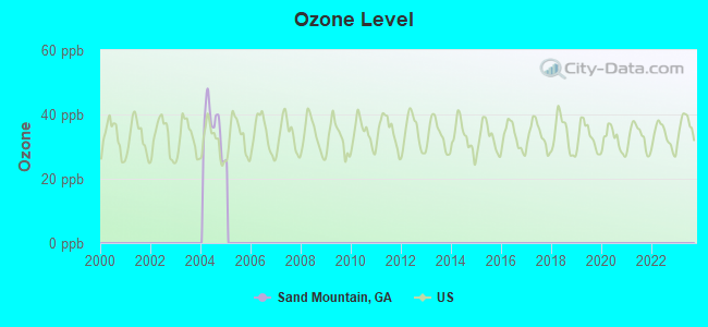
Ozone [ppb] level in 2004 was 36.3. This is about average. Closest monitor was 9.5 miles away from the city center.
| City: | 36.3 |
| U.S.: | 33.3 |
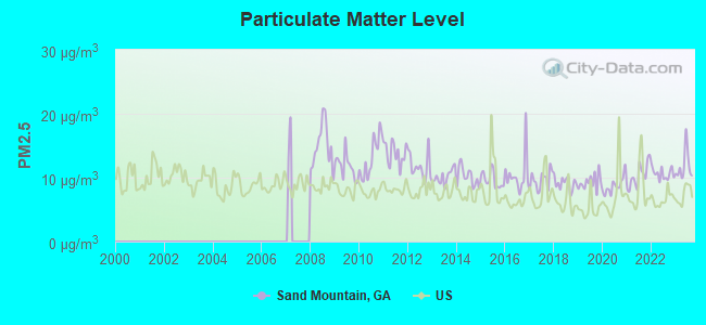
Particulate Matter (PM2.5) [µg/m3] level in 2023 was 11.8. This is significantly worse than average. Closest monitor was 15.4 miles away from the city center.
| City: | 11.8 |
| U.S.: | 8.1 |
Tornado activity:
Sand Mountain-area historical tornado activity is slightly above Georgia state average. It is 77% greater than the overall U.S. average.
On 2/6/2008, a category F4 (max. wind speeds 207-260 mph) tornado 22.8 miles away from the Sand Mountain place center killed one person and injured 12 people.
On 5/19/1973, a category F4 tornado 28.7 miles away from the place center injured 19 people and caused between $500,000 and $5,000,000 in damages.
Earthquake activity:
Sand Mountain-area historical earthquake activity is significantly above Georgia state average. It is 123% greater than the overall U.S. average.On 4/29/2003 at 08:59:39, a magnitude 4.9 (4.4 MB, 4.6 MW, 4.9 LG, Class: Light, Intensity: IV - V) earthquake occurred 28.6 miles away from the city center
On 4/29/2003 at 08:59:39, a magnitude 4.6 (4.6 MW, Depth: 12.3 mi) earthquake occurred 28.7 miles away from Sand Mountain center
On 11/30/1973 at 07:48:41, a magnitude 4.7 (4.7 MB, 4.6 ML) earthquake occurred 109.2 miles away from the city center
On 1/18/1999 at 07:00:53, a magnitude 4.8 (4.8 MB, 4.0 LG, Depth: 0.6 mi) earthquake occurred 142.1 miles away from Sand Mountain center
On 12/12/2018 at 09:14:43, a magnitude 4.4 (4.4 MW, Depth: 4.9 mi) earthquake occurred 67.6 miles away from the city center
On 4/18/2008 at 09:36:59, a magnitude 5.4 (5.1 MB, 4.8 MS, 5.4 MW, 5.2 MW, Class: Moderate, Intensity: VI - VII) earthquake occurred 277.3 miles away from Sand Mountain center
Magnitude types: regional Lg-wave magnitude (LG), body-wave magnitude (MB), local magnitude (ML), surface-wave magnitude (MS), moment magnitude (MW)
Natural disasters:
The number of natural disasters in Dade County (14) is near the US average (15).Major Disasters (Presidential) Declared: 9
Emergencies Declared: 4
Causes of natural disasters: Floods: 5, Tornadoes: 5, Storms: 4, Hurricanes: 3, Winter Storms: 3, Winds: 2, Drought: 1, Heavy Rain: 1, Snowfall: 1, Other: 1 (Note: some incidents may be assigned to more than one category).
Hospitals and medical centers near Sand Mountain:
- BRIDGE AT SOUTH PITTSBURG, THE (Nursing Home, about 11 miles away; SOUTH PITTSBURG, TN)
- ORANGE GROVE CENTER/CARL SWAFF (Hospital, about 13 miles away; CHATTANOOGA, TN)
- MOUNTAIN VIEW REST HOME (Nursing Home, about 15 miles away; CHATTANOOGA, TN)
- MOCCASSIN BEND MENTAL HEALTH INSTITUTE (Hospital, about 16 miles away; CHATTANOOGA, TN)
- DCI CHATTANOOGA BROAD ST (Dialysis Facility, about 16 miles away; CHATTANOOGA, TN)
- NHC HEALTHCARE ROSSVILLE (Nursing Home, about 16 miles away; ROSSVILLE, GA)
Colleges/universities with over 2000 students nearest to Sand Mountain:
- The University of Tennessee-Chattanooga (about 18 miles; Chattanooga, TN; Full-time enrollment: 10,158)
- Chattanooga State Community College (about 23 miles; Chattanooga, TN; FT enrollment: 6,827)
- Southern Adventist University (about 31 miles; Collegedale, TN; FT enrollment: 2,898)
- Northeast Alabama Community College (about 32 miles; Rainsville, AL; FT enrollment: 2,409)
- Dalton State College (about 33 miles; Dalton, GA; FT enrollment: 3,846)
- Lee University (about 43 miles; Cleveland, TN; FT enrollment: 4,422)
- Cleveland State Community College (about 44 miles; Cleveland, TN; FT enrollment: 2,500)
Points of interest:
Notable locations in Sand Mountain: Sandmont Bible Camp (A), New Home Community Center (B), New Home (C), Davis Volunteer Fire Department Station 7 (D), New Home Fire Department (E). Display/hide their locations on the map
Churches in Sand Mountain include: Avans Church (A), Brown Gap Church (B), General Church (C), Sand Mountain Church (D), Pleasant Grove Church (E), Harris Chapel (F), New Home Church (G), Woodlawn Baptist Church (H), Whiteoak Baptist Church (I). Display/hide their locations on the map
Cemeteries: Brown Gap Cemetery (1), Stephens Cemetery (2), Wells Cemetery (3), Reeves Cemetery (4). Display/hide their locations on the map
Reservoir: Vaught Lake (A). Display/hide its location on the map
Streams, rivers, and creeks: Big Spring Branch (A), Harris Creek (B), Stephens Branch (C), Hurricane Branch (D), Flatrock Creek (E), McBriar Branch (F). Display/hide their locations on the map
| This place: | 2.6 people |
| Georgia: | 2.6 people |
| This place: | 73.7% |
| Whole state: | 68.5% |
| This place: | 3.9% |
| Whole state: | 5.9% |
Likely homosexual households (counted as self-reported same-sex unmarried-partner households)
- Lesbian couples: 0.4% of all households
- Gay men: 0.3% of all households
| This place: | 10.7% |
| Whole state: | 13.0% |
| This place: | 2.6% |
| Whole state: | 6.1% |
People in group quarters in Sand Mountain in 2010:
- 64 people in nursing facilities/skilled-nursing facilities
- 12 people in group homes intended for adults
- 4 people in workers' group living quarters and job corps centers
For population 15 years and over in Sand Mountain:
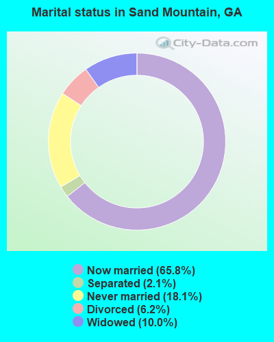
- Never married: 18.1%
- Now married: 65.8%
- Separated: 2.1%
- Widowed: 10.0%
- Divorced: 6.2%
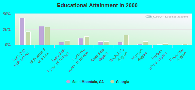
For population 25 years and over in Sand Mountain:
- High school or higher: 56.2%
- Bachelor's degree or higher: 5.8%
- Graduate or professional degree: 1.3%
- Unemployed: 4.2%
- Mean travel time to work (commute): 27.2 minutes
| Here: | 14.3 |
| Georgia average: | 13.3 |
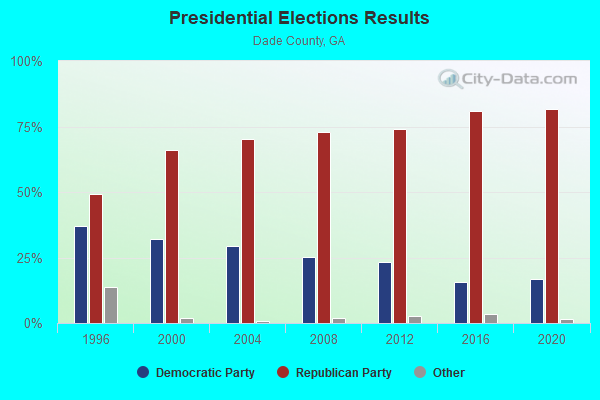
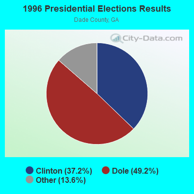


Graphs represent county-level data. Detailed 2008 Election Results
Religion statistics for Sand Mountain, GA (based on Dade County data)
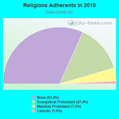
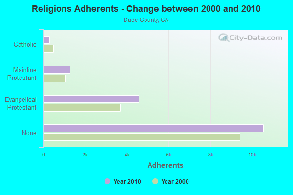
| Religion | Adherents | Congregations |
|---|---|---|
| Evangelical Protestant | 4,562 | 23 |
| Mainline Protestant | 1,254 | 7 |
| Catholic | 274 | 1 |
| Other | 2 | 1 |
| None | 10,541 | - |
Food Environment Statistics:
| Dade County: | 3.10 / 10,000 pop. |
| Georgia: | 1.91 / 10,000 pop. |
| Dade County: | 2.48 / 10,000 pop. |
| State: | 0.86 / 10,000 pop. |
| Dade County: | 8.69 / 10,000 pop. |
| Georgia: | 5.12 / 10,000 pop. |
| Dade County: | 7.45 / 10,000 pop. |
| Georgia: | 7.41 / 10,000 pop. |
| Here: | 11.0% |
| Georgia: | 10.4% |
| Dade County: | 27.3% |
| State: | 27.8% |
| Here: | 10.9% |
| Georgia: | 14.6% |
Strongest AM radio stations in Sand Mountain:
- WWAM (820 AM; daytime; 50 kW; JASPER, TN; Owner: SHELTON BROADCASTING SYSTEM)
- WFLI (1070 AM; 50 kW; LOOKOUT MOUNTAIN, TN; Owner: WFLI, INC.)
- WKWN (1420 AM; 2 kW; TRENTON, GA; Owner: RA-AD OF TRENTON, INC.)
- WEPG (910 AM; 5 kW; SOUTH PITTSBURG, TN; Owner: STONE/COLLINS COMMUNICATIONS, INC.)
- WQRX (870 AM; daytime; 10 kW; VALLEY HEAD, AL; Owner: BARINOWSKI INVESTMENT COMPANY)
- WDEF (1370 AM; 5 kW; CHATTANOOGA, TN; Owner: JACKSON TELECASTERS, INC)
- WGOW (1150 AM; 5 kW; CHATTANOOGA, TN; Owner: CITADEL BROADCASTING COMPANY)
- WDOD (1310 AM; 5 kW; CHATTANOOGA, TN; Owner: WDOD OF CHATTANOOGA, INC.)
- WNOO (1260 AM; 5 kW; CHATTANOOGA, TN; Owner: PYE BROADCASTING, INC.)
- WNSI (810 AM; 50 kW; JACKSONVILLE, AL; Owner: UNITED BROADCASTING NETWORK, INC.)
- WYMR (1480 AM; 1 kW; BRIDGEPORT, AL; Owner: DADE COUNTY BROADCASTING, INC.)
- WLOR (1550 AM; 50 kW; HUNTSVILLE, AL; Owner: BCA RADIO, LLC)
- WQCH (1590 AM; 5 kW; LAFAYETTE, GA; Owner: RADIX BROADCASTING, INC.)
Strongest FM radio stations in Sand Mountain:
- WBDX (102.7 FM; TRENTON, GA; Owner: PARTNERS FOR CHRISTIAN RADIO, INC.)
- WMBW (88.9 FM; CHATTANOOGA, TN; Owner: THE MOODY BIBLE INSTITUTE OF CHICAGO)
- W257AZ (99.3 FM; LOOKOUT MOUNTAIN, TN; Owner: CAPSTAR TX LIMITED PARTNERSHIP)
- WMXF-FM (97.3 FM; SOUTH PITTSBURG, TN; Owner: CAPSTAR TX LIMITED PARTNERSHIP)
- WUSY (100.7 FM; CLEVELAND, TN; Owner: CAPSTAR TX LIMITED PARTNERSHIP)
- WDEF-FM (92.3 FM; CHATTANOOGA, TN; Owner: JACKSON TELECASTERS, INC.)
- WMXN-FM (101.7 FM; STEVENSON, AL; Owner: KEA RADIO, INC.)
- WKXJ (98.1 FM; SIGNAL MOUNTAIN, TN; Owner: CAPSTAR TX LIMITED PARTNERSHIP)
- WDOD-FM (96.5 FM; CHATTANOOGA, TN; Owner: WDOD OF CHATTANOOGA, INC.)
- WSKZ (106.5 FM; CHATTANOOGA, TN; Owner: CITADEL BROADCASTING COMPANY)
- WAWL-FM (91.5 FM; RED BANK, TN; Owner: CHATTANOOGA STATE TECHNICAL COMMUNITY COLLEGE)
- WOGT (107.9 FM; EAST RIDGE, TN; Owner: CITADEL BROADCASTING COMPANY)
- W278AC (103.5 FM; WALDEN, TN; Owner: CAPSTAR TX LIMITED PARTNERSHIP)
- W284AE (104.7 FM; ORCHARD HILLS, GA; Owner: WAY-FM MEDIA GROUP, INC.)
- WRXR-FM (105.5 FM; ROSSVILLE, GA; Owner: CAPSTAR TX LIMITED PARTNERSHIP)
- WDYN (89.7 FM; CHATTANOOGA, TN; Owner: TENNESSEE TEMPLE UNIVERSITY)
- WLOV-FM1 (97.3 FM; CHATTANOOGA, TN; Owner: CAPSTAR TX LIMITED PARTNERSHIP)
- WUTC (88.1 FM; CHATTANOOGA, TN; Owner: UNIVERSITY OF TENNESSEE)
- W241AF (96.1 FM; ROSSVILLE, GA; Owner: IMMANUEL BROADCASTING NETWORK, INC.)
- WSMC-FM (90.5 FM; COLLEGEDALE, TN; Owner: SOUTHERN COLLEGE OF SEVENTH-DAY ADVT)
TV broadcast stations around Sand Mountain:
- WFLI-TV (Channel 53; CLEVELAND, TN; Owner: CHATTANOOGA MEDIA HOLDINGS, L.L.C.)
- WELF (Channel 23; DALTON, GA; Owner: TRINITY BROADCASTING NETWORK)
- WDEF-TV (Channel 12; CHATTANOOGA, TN; Owner: MEDIA GENERAL COMMUNICATIONS, INC.)
- W64BJ (Channel 64; SCOTTSBORO, AL; Owner: TRINITY BROADCASTING NETWORK)
- WDSI-TV (Channel 61; CHATTANOOGA, TN; Owner: WDSI LICENSE CORP.)
- WRCB-TV (Channel 3; CHATTANOOGA, TN; Owner: SARKES TARZIAN, INC.)
- WTCI (Channel 45; CHATTANOOGA, TN; Owner: THE GREATER CHATTANOOGA PUBLIC TELEVISION CORP)
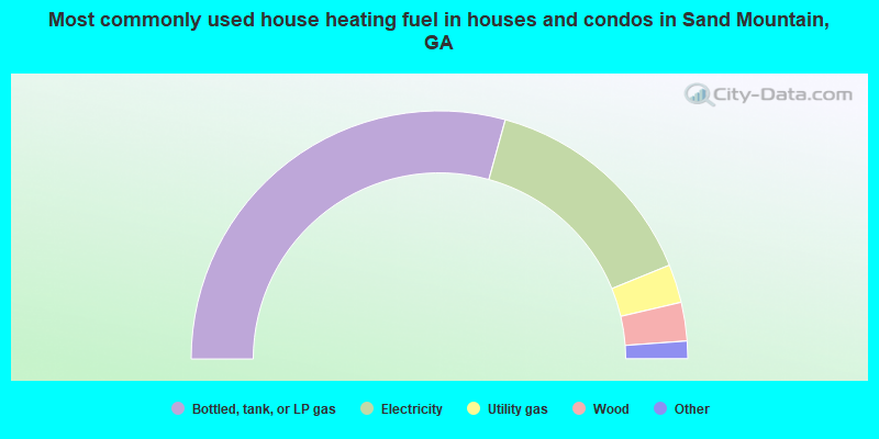
- 58.5%Bottled, tank, or LP gas
- 29.1%Electricity
- 5.0%Utility gas
- 5.0%Wood
- 1.8%Fuel oil, kerosene, etc.
- 0.5%Other fuel
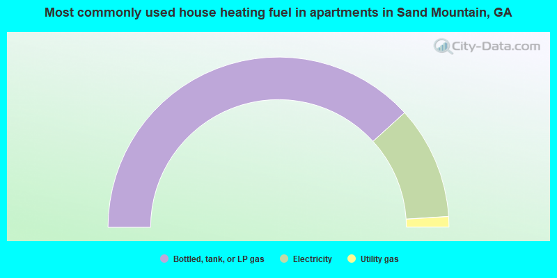
- 76.5%Bottled, tank, or LP gas
- 21.5%Electricity
- 2.0%Utility gas
Sand Mountain compared to Georgia state average:
- Median house value below state average.
- Unemployed percentage significantly below state average.
- Black race population percentage significantly below state average.
- Hispanic race population percentage significantly below state average.
- Foreign-born population percentage significantly below state average.
- Renting percentage below state average.
- Length of stay since moving in significantly above state average.
- Number of rooms per house significantly below state average.
- House age significantly below state average.
- Number of college students below state average.
- Percentage of population with a bachelor's degree or higher significantly below state average.
State forum archive:
- Georgia Pages: 2 3 4 5 6 7 8 9 10 11 12 13 14 15 16 17 18 19 20 21 22 23 24 25 26 27 28 29 30 31 32 33 34 35 36 37
- Atlanta Pages: 2 3 4 5 6 7 8 9 10 11 12 13 14 15 16 17 18 19 20 21 22 23 24 25 26 27 28 29 30 31 32 33 34 35 36 37 38 39 40 41 42 43 44 45 46 47 48 49 50 51 52 53 54 55 56 57 58 59 60 61 62 63 64 65 66 67 68 69 70 71 72 73 74 75 76 77 78 79 80 81 82 83 84 85 86 87 88 89 90 91 92 93 94 95 96 97 98 99 100 101 102 103 104 105 106 107 108 109 110 111 112 113 114 115 116 117 118 119 120 121 122 123 124 125 126 127 128 129 130 131 132 133 134 135 136 137 138 139 140 141 142 143 144 145 146 147 148 149 150 151 152 153 154 155 156 157 158 159 160 161 162 163 164 165 166 167 168 169 170 171 172 173 174 175 176 177 178 179 180 181 182 183
- Augusta area Pages: 2 3 4 5 6 7 8 9 10 11 12 13 14 15 16
- Columbus, GA Pages: 2 3 4 5 6 7 8 9 10
- Macon Pages: 2 3 4 5 6 7 8
- Savannah area Pages: 2 3 4 5 6 7 8 9 10 11 12 13 14 15 16 17 18 19 20 21 22