Fairyland, Georgia
Submit your own pictures of this place and show them to the world
- OSM Map
- General Map
- Google Map
- MSN Map

| Males: 1,500 | |
| Females: 1,584 |
| Median resident age: | 37.3 years |
| Georgia median age: | 33.4 years |
Zip code: 30750
| Fairyland: | $76,156 |
| GA: | $72,837 |
Estimated per capita income in 2022: $44,547 (it was $24,685 in 2000)
Fairyland CCD income, earnings, and wages data
Estimated median house or condo value in 2022: $382,558 (it was $142,400 in 2000)
| Fairyland: | $382,558 |
| GA: | $297,400 |
Mean prices in 2022: all housing units: $205,717; detached houses: $221,135; townhouses or other attached units: $174,404; in 2-unit structures: $100,864; in 5-or-more-unit structures: $240,901; mobile homes: $70,670
Detailed information about poverty and poor residents in Fairyland, GA


- 2,88698.8%White alone
- 160.5%Hispanic
- 120.4%Two or more races
- 30.1%Asian alone
- 20.07%Black alone
- 10.03%American Indian alone

Races in Fairyland detailed stats: ancestries, foreign born residents, place of birth
 Recent articles from our blog. Our writers, many of them Ph.D. graduates or candidates, create easy-to-read articles on a wide variety of topics.
Current Local Time: EST time zone
Land area: 25.8 square miles.
Population density: 120 people per square mile (very low).

| Fairyland CCD: | 0.9% ($1,265) |
| Georgia: | 0.9% ($919) |
Nearest city with pop. 50,000+: Chattanooga, TN  (11.5 miles , pop. 155,554).
Nearest city with pop. 200,000+: Atlanta, GA (97.6 miles , pop. 416,474).
Nearest city with pop. 1,000,000+: Chicago, IL (495.0 miles , pop. 2,896,016).
Nearest cities:
), ), )Latitude: 34.91 N, Longitude: 85.39 W
Area code commonly used in this area: 706


| Here: | 2.8% |
| Georgia: | 2.9% |

- Educational services (9.4%)
- Professional, scientific, technical services (8.2%)
- Finance & insurance (7.4%)
- Construction (7.1%)
- Health care (6.5%)
- Religious, grantmaking, civic, professional, similar organizations (4.6%)
- Arts, entertainment, recreation (4.4%)

- Construction (11.3%)
- Professional, scientific, technical services (10.3%)
- Finance & insurance (8.0%)
- Educational services (6.6%)
- Administrative & support & waste management services (5.4%)
- Truck transportation (4.8%)
- Metal & metal products (4.6%)

- Health care (13.9%)
- Educational services (13.2%)
- Finance & insurance (6.4%)
- Arts, entertainment, recreation (6.2%)
- Accommodation & food services (5.9%)
- Religious, grantmaking, civic, professional, similar organizations (5.5%)
- Professional, scientific, technical services (5.2%)

- Other sales and related occupations, including supervisors (6.6%)
- Other management occupations, except farmers and farm managers (6.0%)
- Sales representatives, services, wholesale and manufacturing (5.1%)
- Cashiers (3.8%)
- Other production occupations, including supervisors (3.6%)
- Building and grounds cleaning and maintenance occupations (3.4%)
- Driver/sales workers and truck drivers (3.3%)

- Sales representatives, services, wholesale and manufacturing (8.2%)
- Other sales and related occupations, including supervisors (6.5%)
- Driver/sales workers and truck drivers (5.7%)
- Other production occupations, including supervisors (5.1%)
- Other management occupations, except farmers and farm managers (4.8%)
- Building and grounds cleaning and maintenance occupations (4.6%)
- Lawyers (4.6%)

- Secretaries and administrative assistants (7.9%)
- Other management occupations, except farmers and farm managers (7.7%)
- Cashiers (7.7%)
- Other sales and related occupations, including supervisors (6.8%)
- Preschool, kindergarten, elementary, and middle school teachers (6.2%)
- Other office and administrative support workers, including supervisors (5.5%)
- Health technologists and technicians (4.5%)
Average climate in Fairyland, Georgia
Based on data reported by over 4,000 weather stations


(lower is better)

Air Quality Index (AQI) level in 2023 was 94.7. This is worse than average.
| City: | 94.7 |
| U.S.: | 72.6 |

Nitrogen Dioxide (NO2) [ppb] level in 2004 was 3.44. This is significantly better than average. Closest monitor was 6.7 miles away from the city center.
| City: | 3.44 |
| U.S.: | 5.11 |

Sulfur Dioxide (SO2) [ppb] level in 2007 was 2.27. This is significantly worse than average. Closest monitor was 6.7 miles away from the city center.
| City: | 2.27 |
| U.S.: | 1.51 |

Ozone [ppb] level in 2023 was 35.8. This is about average. Closest monitor was 8.3 miles away from the city center.
| City: | 35.8 |
| U.S.: | 33.3 |

Particulate Matter (PM2.5) [µg/m3] level in 2023 was 11.9. This is significantly worse than average. Closest monitor was 6.7 miles away from the city center.
| City: | 11.9 |
| U.S.: | 8.1 |
Tornado activity:
Fairyland-area historical tornado activity is slightly above Georgia state average. It is 65% greater than the overall U.S. average.
On 2/6/2008, a category F4 (max. wind speeds 207-260 mph) tornado 30.7 miles away from the Fairyland place center killed one person and injured 12 people.
On 5/19/1973, a category F4 tornado 32.7 miles away from the place center injured 19 people and caused between $500,000 and $5,000,000 in damages.
Earthquake activity:
Fairyland-area historical earthquake activity is significantly above Georgia state average. It is 117% greater than the overall U.S. average.On 4/29/2003 at 08:59:39, a magnitude 4.9 (4.4 MB, 4.6 MW, 4.9 LG, Class: Light, Intensity: IV - V) earthquake occurred 32.0 miles away from Fairyland center
On 4/29/2003 at 08:59:39, a magnitude 4.6 (4.6 MW, Depth: 12.3 mi) earthquake occurred 32.1 miles away from the city center
On 11/30/1973 at 07:48:41, a magnitude 4.7 (4.7 MB, 4.6 ML) earthquake occurred 101.1 miles away from the city center
On 12/12/2018 at 09:14:43, a magnitude 4.4 (4.4 MW, Depth: 4.9 mi) earthquake occurred 60.9 miles away from Fairyland center
On 1/18/1999 at 07:00:53, a magnitude 4.8 (4.8 MB, 4.0 LG, Depth: 0.6 mi) earthquake occurred 149.3 miles away from the city center
On 8/2/1974 at 08:52:09, a magnitude 4.9 (4.3 MB, 4.9 LG) earthquake occurred 180.5 miles away from Fairyland center
Magnitude types: regional Lg-wave magnitude (LG), body-wave magnitude (MB), local magnitude (ML), moment magnitude (MW)
Natural disasters:
The number of natural disasters in Walker County (14) is near the US average (15).Major Disasters (Presidential) Declared: 9
Emergencies Declared: 4
Causes of natural disasters: Floods: 6, Storms: 5, Tornadoes: 5, Winter Storms: 4, Hurricanes: 2, Drought: 1, Snowfall: 1, Wind: 1, Other: 1 (Note: some incidents may be assigned to more than one category).
Hospitals and medical centers near Fairyland:
- MOUNTAIN VIEW REST HOME (Nursing Home, about 7 miles away; CHATTANOOGA, TN)
- NHC HEALTHCARE ROSSVILLE (Nursing Home, about 7 miles away; ROSSVILLE, GA)
- PARKSIDE AT HUTCHESON MED CTR (Nursing Home, about 8 miles away; ROSSVILLE, GA)
- ORANGE GROVE CENTER/CARL SWAFF (Hospital, about 8 miles away; CHATTANOOGA, TN)
- DCI FORT OGLETHORPE (Dialysis Facility, about 8 miles away; FORT OGLETHORPE, GA)
- GEORGIA HOME CARE OF FORT OGLETHORPE (Home Health Center, about 8 miles away; FORT OGLETHORPE, GA)
- HUTCHESON HOME CARE/HOSPICE (Hospital, about 8 miles away; FORT OGLETHORPE, GA)
Colleges/universities with over 2000 students nearest to Fairyland:
- The University of Tennessee-Chattanooga (about 11 miles; Chattanooga, TN; Full-time enrollment: 10,158)
- Chattanooga State Community College (about 16 miles; Chattanooga, TN; FT enrollment: 6,827)
- Southern Adventist University (about 22 miles; Collegedale, TN; FT enrollment: 2,898)
- Dalton State College (about 24 miles; Dalton, GA; FT enrollment: 3,846)
- Lee University (about 35 miles; Cleveland, TN; FT enrollment: 4,422)
- Cleveland State Community College (about 36 miles; Cleveland, TN; FT enrollment: 2,500)
- Northeast Alabama Community College (about 40 miles; Rainsville, AL; FT enrollment: 2,409)
Points of interest:
Notable locations in Fairyland: Camp Lookout (A), Rock City Gardens (B), Lookout Mountain Golf Club (C), Lookout Mountain City Hall (D), Walker County Emergency Services Station 4 Hinkle (E), Lookout Mountain Fire Department (F). Display/hide their locations on the map
Churches in Fairyland include: Hinkles Church (A), Ascalon Church (B), Lookout Mountain Church (C), Mount Olive Church (D), New Lookout Church (E), Payne Chapel (F), Our Lady of the Mountain Church (G), Lookout Mountain United Methodist Church (H). Display/hide their locations on the map
Cemeteries: Mills Cemetery (1), Mount Olive Cemetery (2), Paynes Chapel Cemetery (3). Display/hide their locations on the map
Lake: Lula Lake (A). Display/hide its location on the map
Streams, rivers, and creeks: Tucker Branch (A), Geber Branch (B), Fuggett Branch (C), Long Branch (D). Display/hide their locations on the map
| This place: | 2.6 people |
| Georgia: | 2.6 people |
| This place: | 68.2% |
| Whole state: | 70.7% |
| This place: | 1.6% |
| Whole state: | 4.8% |
Likely homosexual households (counted as self-reported same-sex unmarried-partner households)
- Lesbian couples: 0.1% of all households
- Gay men: 0.3% of all households
| This place: | 5.4% |
| Whole state: | 13.0% |
| This place: | 1.9% |
| Whole state: | 6.1% |
For population 15 years and over in Fairyland:

- Never married: 16.7%
- Now married: 67.7%
- Separated: 0.0%
- Widowed: 7.0%
- Divorced: 8.6%
For population 25 years and over in Fairyland:
- High school or higher: 84.4%
- Bachelor's degree or higher: 42.4%
- Graduate or professional degree: 15.5%
- Unemployed: 2.4%
- Mean travel time to work (commute): 25.6 minutes


| Here: | 12.7 |
| Georgia average: | 13.3 |
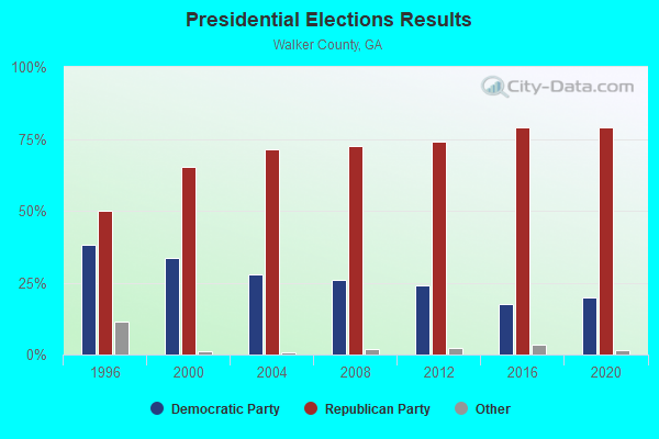
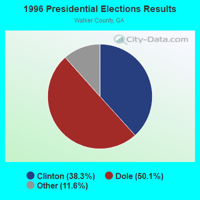
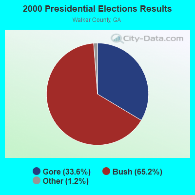
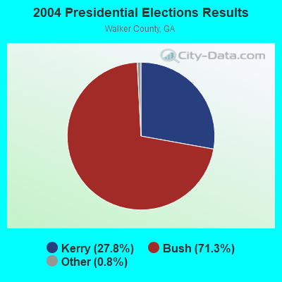
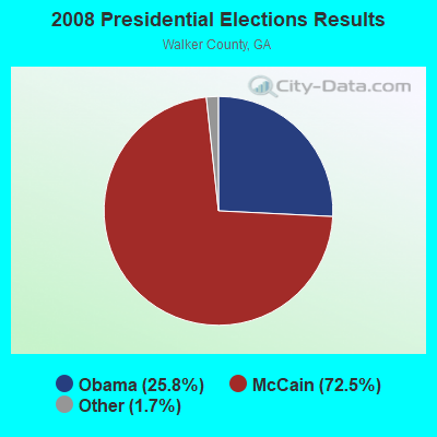
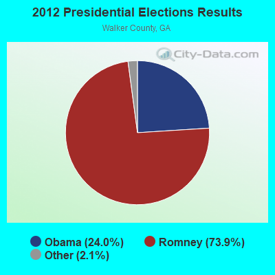
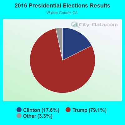
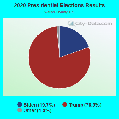
Graphs represent county-level data. Detailed 2008 Election Results
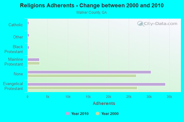
Religion statistics for Fairyland, GA (based on Walker County data)
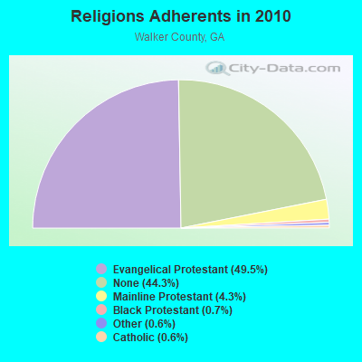
| Religion | Adherents | Congregations |
|---|---|---|
| Evangelical Protestant | 34,045 | 109 |
| Mainline Protestant | 2,948 | 16 |
| Black Protestant | 474 | 4 |
| Other | 419 | 3 |
| Catholic | 410 | 1 |
| None | 30,460 | - |
Food Environment Statistics:
| Walker County: | 1.71 / 10,000 pop. |
| Georgia: | 1.91 / 10,000 pop. |
| Walker County: | 0.16 / 10,000 pop. |
| State: | 0.15 / 10,000 pop. |
| Walker County: | 1.09 / 10,000 pop. |
| State: | 0.86 / 10,000 pop. |
| This county: | 5.74 / 10,000 pop. |
| Georgia: | 5.12 / 10,000 pop. |
| This county: | 3.57 / 10,000 pop. |
| Georgia: | 7.41 / 10,000 pop. |
| This county: | 11.7% |
| State: | 10.4% |
| Here: | 28.4% |
| Georgia: | 27.8% |
| Here: | 12.0% |
| Georgia: | 14.6% |
Strongest AM radio stations in Fairyland:
- WFLI (1070 AM; 50 kW; LOOKOUT MOUNTAIN, TN; Owner: WFLI, INC.)
- WWAM (820 AM; daytime; 50 kW; JASPER, TN; Owner: SHELTON BROADCASTING SYSTEM)
- WDEF (1370 AM; 5 kW; CHATTANOOGA, TN; Owner: JACKSON TELECASTERS, INC)
- WGOW (1150 AM; 5 kW; CHATTANOOGA, TN; Owner: CITADEL BROADCASTING COMPANY)
- WKWN (1420 AM; 2 kW; TRENTON, GA; Owner: RA-AD OF TRENTON, INC.)
- WNOO (1260 AM; 5 kW; CHATTANOOGA, TN; Owner: PYE BROADCASTING, INC.)
- WDOD (1310 AM; 5 kW; CHATTANOOGA, TN; Owner: WDOD OF CHATTANOOGA, INC.)
- WEPG (910 AM; 5 kW; SOUTH PITTSBURG, TN; Owner: STONE/COLLINS COMMUNICATIONS, INC.)
- WTTI (1530 AM; daytime; 10 kW; DALTON, GA; Owner: PYE WILSON BROADCASTING, INC.)
- WQRX (870 AM; daytime; 10 kW; VALLEY HEAD, AL; Owner: BARINOWSKI INVESTMENT COMPANY)
- WQCH (1590 AM; 5 kW; LAFAYETTE, GA; Owner: RADIX BROADCASTING, INC.)
- WUUS (980 AM; 0 kW; ROSSVILLE, GA; Owner: CAPSTAR TX LIMITED PARTNERSHIP)
- WNSI (810 AM; 50 kW; JACKSONVILLE, AL; Owner: UNITED BROADCASTING NETWORK, INC.)
Strongest FM radio stations in Fairyland:
- WMBW (88.9 FM; CHATTANOOGA, TN; Owner: THE MOODY BIBLE INSTITUTE OF CHICAGO)
- WBDX (102.7 FM; TRENTON, GA; Owner: PARTNERS FOR CHRISTIAN RADIO, INC.)
- W257AZ (99.3 FM; LOOKOUT MOUNTAIN, TN; Owner: CAPSTAR TX LIMITED PARTNERSHIP)
- WAWL-FM (91.5 FM; RED BANK, TN; Owner: CHATTANOOGA STATE TECHNICAL COMMUNITY COLLEGE)
- W284AE (104.7 FM; ORCHARD HILLS, GA; Owner: WAY-FM MEDIA GROUP, INC.)
- WLOV-FM1 (97.3 FM; CHATTANOOGA, TN; Owner: CAPSTAR TX LIMITED PARTNERSHIP)
- W241AF (96.1 FM; ROSSVILLE, GA; Owner: IMMANUEL BROADCASTING NETWORK, INC.)
- WUSY (100.7 FM; CLEVELAND, TN; Owner: CAPSTAR TX LIMITED PARTNERSHIP)
- WDEF-FM (92.3 FM; CHATTANOOGA, TN; Owner: JACKSON TELECASTERS, INC.)
- WRXR-FM (105.5 FM; ROSSVILLE, GA; Owner: CAPSTAR TX LIMITED PARTNERSHIP)
- WKXJ (98.1 FM; SIGNAL MOUNTAIN, TN; Owner: CAPSTAR TX LIMITED PARTNERSHIP)
- WDOD-FM (96.5 FM; CHATTANOOGA, TN; Owner: WDOD OF CHATTANOOGA, INC.)
- WSKZ (106.5 FM; CHATTANOOGA, TN; Owner: CITADEL BROADCASTING COMPANY)
- WOGT (107.9 FM; EAST RIDGE, TN; Owner: CITADEL BROADCASTING COMPANY)
- W278AC (103.5 FM; WALDEN, TN; Owner: CAPSTAR TX LIMITED PARTNERSHIP)
- WMXF-FM (97.3 FM; SOUTH PITTSBURG, TN; Owner: CAPSTAR TX LIMITED PARTNERSHIP)
- WDYN (89.7 FM; CHATTANOOGA, TN; Owner: TENNESSEE TEMPLE UNIVERSITY)
- WSGC-FM (101.9 FM; RINGGOLD, GA; Owner: CLEAR CHANNEL BROADCASTING LICENSES, INC.)
- WUTC (88.1 FM; CHATTANOOGA, TN; Owner: UNIVERSITY OF TENNESSEE)
- W268AA (101.5 FM; FALLING WATER, TN; Owner: S/WEST FLORIDA COMMUNITY RADIO, INC.)
TV broadcast stations around Fairyland:
- WELF (Channel 23; DALTON, GA; Owner: TRINITY BROADCASTING NETWORK)
- WFLI-TV (Channel 53; CLEVELAND, TN; Owner: CHATTANOOGA MEDIA HOLDINGS, L.L.C.)
- WDEF-TV (Channel 12; CHATTANOOGA, TN; Owner: MEDIA GENERAL COMMUNICATIONS, INC.)
- WDSI-TV (Channel 61; CHATTANOOGA, TN; Owner: WDSI LICENSE CORP.)
- WRCB-TV (Channel 3; CHATTANOOGA, TN; Owner: SARKES TARZIAN, INC.)
- WTCI (Channel 45; CHATTANOOGA, TN; Owner: THE GREATER CHATTANOOGA PUBLIC TELEVISION CORP)
- WTVC (Channel 9; CHATTANOOGA, TN; Owner: FREEDOM BROADCASTING OF TENNESSEE, INC.)
- W26BE (Channel 26; CHATTANOOGA, TN; Owner: THREE ANGELS BROADCASTING NETWORK)
- W66CG (Channel 66; ACTON, TN; Owner: MS COMMUNICATIONS, LLC)
- WOOT-LP (Channel 6; CHATTANOOGA, ETC., TN; Owner: TIGER EYE BROADCASTING CORPORATION)
FCC Registered Microwave Towers:
1- West Brow Lookout Mountain (Lat: 34.966722 Lon: -85.373833), Structure height: 30.5 m, Overall height: 34.4 m, Call Sign: WPNJ684,
Assigned Frequencies: 952.831 MHz, 928.831 MHz, Grant Date: 02/04/1998, Expiration Date: 02/04/2003, Cancellation Date: 05/11/2003, Phone: (401) 827-5810

- 45.2%Utility gas
- 26.8%Electricity
- 24.4%Bottled, tank, or LP gas
- 2.0%Wood
- 1.6%Fuel oil, kerosene, etc.

- 44.8%Electricity
- 29.7%Utility gas
- 17.0%Bottled, tank, or LP gas
- 8.5%No fuel used
Fairyland compared to Georgia state average:
- Unemployed percentage significantly below state average.
- Black race population percentage significantly below state average.
- Hispanic race population percentage significantly below state average.
- Foreign-born population percentage significantly below state average.
- Renting percentage significantly below state average.
- Length of stay since moving in significantly above state average.
- Number of rooms per house significantly below state average.
- House age significantly below state average.
- Percentage of population with a bachelor's degree or higher above state average.