Parkers Lake, Kentucky
Submit your own pictures of this place and show them to the world
- OSM Map
- General Map
- Google Map
- MSN Map

| Males: 1,278 | |
| Females: 1,221 |
| Median resident age: | 34.4 years |
| Kentucky median age: | 35.9 years |
Zip code: 42634
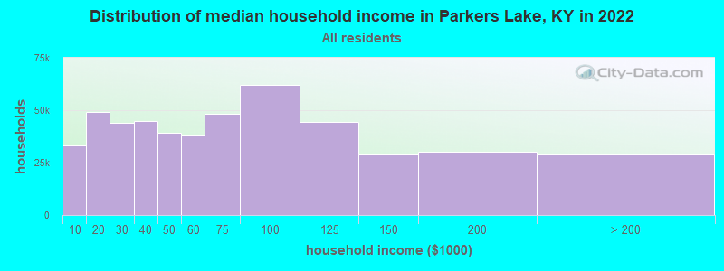
| Parkers Lake: | $32,382 |
| KY: | $59,341 |
Estimated per capita income in 2022: $18,654 (it was $10,434 in 2000)
Parkers Lake CCD income, earnings, and wages data
Estimated median house or condo value in 2022: $67,978 (it was $26,300 in 2000)
| Parkers Lake: | $67,978 |
| KY: | $196,300 |
Detailed information about poverty and poor residents in Parkers Lake, KY


- 2,34997.9%White alone
- 251.0%Two or more races
- 130.5%American Indian alone
- 100.4%Hispanic
- 20.08%Black alone

Races in Parkers Lake detailed stats: ancestries, foreign born residents, place of birth
According to our research of Kentucky and other state lists, there were 6 registered sex offenders living in Parkers Lake, Kentucky as of May 22, 2024.
The ratio of all residents to sex offenders in Parkers Lake is 417 to 1.
The ratio of registered sex offenders to all residents in this city is near the state average.
 Recent articles from our blog. Our writers, many of them Ph.D. graduates or candidates, create easy-to-read articles on a wide variety of topics.
Current Local Time: EST time zone
Land area: 126.3 square miles.
Population density: 20 people per square mile (very low).

| Parkers Lake CCD: | 0.8% ($199) |
| Kentucky: | 0.8% ($610) |
Nearest city with pop. 50,000+: Knoxville, TN  (67.3 miles , pop. 173,890).
Nearest city with pop. 200,000+: Fayette, KY (80.9 miles , pop. 260,512).
Nearest city with pop. 1,000,000+: Chicago, IL (385.6 miles , pop. 2,896,016).
Nearest cities:
), ), ), )Latitude: 36.86 N, Longitude: 84.43 W
Area code commonly used in this area: 606

| Here: | 5.4% |
| Kentucky: | 3.8% |

- Educational services (16.5%)
- Transportation equipment (11.6%)
- Health care (10.1%)
- Accommodation & food services (8.2%)
- Food & beverage stores (6.0%)
- Construction (5.4%)
- Agriculture, forestry, fishing & hunting (3.8%)

- Transportation equipment (13.2%)
- Construction (11.5%)
- Educational services (11.2%)
- Agriculture, forestry, fishing & hunting (6.4%)
- Machinery (4.7%)
- Building material & garden equipment & supplies dealers (4.7%)
- Mining, quarrying, oil & gas extraction (4.1%)

- Educational services (21.1%)
- Health care (16.0%)
- Accommodation & food services (15.4%)
- Transportation equipment (10.1%)
- Food & beverage stores (8.0%)
- Apparel (5.3%)
- Department & other general merchandise stores (4.2%)

- Textile, apparel, and furnishings workers (10.6%)
- Preschool, kindergarten, elementary, and middle school teachers (4.9%)
- Cooks and food preparation workers (4.7%)
- Secretaries and administrative assistants (4.3%)
- Cashiers (4.1%)
- Vehicle and mobile equipment mechanics, installers, and repairers (4.1%)
- Other production occupations, including supervisors (3.8%)

- Vehicle and mobile equipment mechanics, installers, and repairers (8.8%)
- Driver/sales workers and truck drivers (8.1%)
- Metal workers and plastic workers (7.1%)
- Textile, apparel, and furnishings workers (6.4%)
- Electrical equipment mechanics and other installation, maintenance, and repair workers, including supervisors (6.1%)
- Laborers and material movers, hand (6.1%)
- Supervisors, construction and extraction workers (5.8%)

- Textile, apparel, and furnishings workers (14.2%)
- Preschool, kindergarten, elementary, and middle school teachers (9.2%)
- Cooks and food preparation workers (8.9%)
- Secretaries and administrative assistants (8.0%)
- Cashiers (7.7%)
- Nursing, psychiatric, and home health aides (4.7%)
- Food and beverage serving workers, except waiters and waitresses (4.5%)
Average climate in Parkers Lake, Kentucky
Based on data reported by over 4,000 weather stations


(lower is better)

Air Quality Index (AQI) level in 2022 was 62.9. This is about average.
| City: | 62.9 |
| U.S.: | 72.6 |

Ozone [ppb] level in 2022 was 28.6. This is about average. Closest monitor was 19.1 miles away from the city center.
| City: | 28.6 |
| U.S.: | 33.3 |

Particulate Matter (PM2.5) [µg/m3] level in 2022 was 7.87. This is about average. Closest monitor was 19.1 miles away from the city center.
| City: | 7.87 |
| U.S.: | 8.11 |
Tornado activity:
Parkers Lake-area historical tornado activity is slightly below Kentucky state average. It is 0% greater than the overall U.S. average.
On 4/3/1974, a category F4 (max. wind speeds 207-260 mph) tornado 9.3 miles away from the Parkers Lake place center .
On 4/3/1974, a category F4 tornado 19.2 miles away from the place center killed 10 people and injured 113 people and caused between $5000 and $50,000 in damages.
Earthquake activity:
Parkers Lake-area historical earthquake activity is significantly above Kentucky state average. It is 88% greater than the overall U.S. average.On 7/27/1980 at 18:52:21, a magnitude 5.2 (5.1 MB, 4.7 MS, 5.0 UK, 5.2 UK, Class: Moderate, Intensity: VI - VII) earthquake occurred 96.8 miles away from the city center
On 4/18/2008 at 09:36:59, a magnitude 5.4 (5.1 MB, 4.8 MS, 5.4 MW, 5.2 MW) earthquake occurred 218.7 miles away from the city center
On 11/30/1973 at 07:48:41, a magnitude 4.7 (4.7 MB, 4.6 ML, Class: Light, Intensity: IV - V) earthquake occurred 78.0 miles away from the city center
On 8/9/2020 at 12:07:37, a magnitude 5.1 (5.1 MW, Depth: 4.7 mi) earthquake occurred 187.3 miles away from Parkers Lake center
On 9/7/1988 at 02:28:09, a magnitude 4.6 (4.5 MB, 4.6 LG) earthquake occurred 93.8 miles away from the city center
On 4/18/2008 at 09:36:59, a magnitude 5.2 (5.2 MW, Depth: 8.9 mi) earthquake occurred 218.7 miles away from Parkers Lake center
Magnitude types: regional Lg-wave magnitude (LG), body-wave magnitude (MB), local magnitude (ML), surface-wave magnitude (MS), moment magnitude (MW)
Natural disasters:
The number of natural disasters in McCreary County (13) is near the US average (15).Major Disasters (Presidential) Declared: 7
Emergencies Declared: 2
Causes of natural disasters: Storms: 5, Floods: 4, Fires: 2, Landslides: 2, Mudslides: 2, Tornadoes: 2, Winter Storms: 2, Blizzard: 1, Freeze: 1, Hurricane: 1, Snow: 1, Snowfall: 1, Wind: 1, Other: 1 (Note: some incidents may be assigned to more than one category).
Colleges/universities with over 2000 students nearest to Parkers Lake:
- Somerset Community College (about 18 miles; Somerset, KY; Full-time enrollment: 4,698)
- University of the Cumberlands (about 18 miles; Williamsburg, KY; FT enrollment: 3,585)
- Lincoln Memorial University (about 48 miles; Harrogate, TN; FT enrollment: 3,706)
- Lindsey Wilson College (about 51 miles; Columbia, KY; FT enrollment: 2,552)
- Campbellsville University (about 61 miles; Campbellsville, KY; FT enrollment: 2,948)
- Eastern Kentucky University (about 62 miles; Richmond, KY; FT enrollment: 13,525)
- Pellissippi State Community College (about 65 miles; Knoxville, TN; FT enrollment: 7,271)
Points of interest:
Notable locations in Parkers Lake: Parkers Lake (A), Three Forks of Beaver Overlook (B), Stearns District Ranger Office (C), Natural Arch Scenic Area (D), Sawyer Boat Ramp (E), Tombstone Junction Amusement Park (F), Straight Creek Recreation Site (G), Sawyer Campground (H), Sam Branch Shelter Campground (I), Daniel Boone National Forest Stearns Ranger District (J), Eagle - Sawyer Fire Protection District Station 2 (K), Wiborg Fire Station (L), Cumberland Falls Fire Station (M), Eagle - Sawyer Fire Department (N). Display/hide their locations on the map
Churches in Parkers Lake include: Cooper Creek Church (A), Rock Branch Church (B), Mill Creek Church (C), Sawyer Church (D), Day Ridge Church (E), Roberts Chapel (F), Pleasant Knob Church (G), Indian Creek Church (H), Green Grove Church (I). Display/hide their locations on the map
Cemeteries: Piney Grove Cemetery (1), Barren Fork Cemetery (2), Mariar Cemetery (3), Keith Cemetery (4), Hughes Cemetery (5), Hickenbottom Cemetery (6), Hamilton Cemetery (7). Display/hide their locations on the map
Streams, rivers, and creeks: Camp Creek (A), Camping Cave Branch (B), Cane Branch (C), Coal Band Branch (D), Cogur Fork (E), Copperas Fork (F), Cox Branch (G), Cutoff Branch (H), Drury Branch (I). Display/hide their locations on the map
Park in Parkers Lake: Beaver Creek Wildlife Management Area (1). Display/hide its location on the map
Court: McCreary Co Court Clerk Office (Cumberland Falls Vot) (1). Display/hide its approximate location on the map
| This place: | 2.6 people |
| Kentucky: | 2.5 people |
| This place: | 69.8% |
| Whole state: | 66.9% |
| This place: | 6.9% |
| Whole state: | 6.4% |
Likely homosexual households (counted as self-reported same-sex unmarried-partner households)
- Lesbian couples: 0.2% of all households
- Gay men: 0.2% of all households
| This place: | 30.1% |
| Whole state: | 15.8% |
| This place: | 13.2% |
| Whole state: | 6.6% |
People in group quarters in Parkers Lake in 2010:
- 48 people in group homes intended for adults
- 22 people in group homes for juveniles (non-correctional)
- 17 people in workers' group living quarters and job corps centers
- 7 people in other noninstitutional facilities
People in group quarters in Parkers Lake in 2000:
- 49 people in homes for the mentally ill
- 28 people in homes for abused, dependent, and neglected children
- 3 people in other nonhousehold living situations
For population 15 years and over in Parkers Lake:

- Never married: 21.0%
- Now married: 61.4%
- Separated: 1.4%
- Widowed: 7.5%
- Divorced: 10.2%
For population 25 years and over in Parkers Lake:
- High school or higher: 49.0%
- Bachelor's degree or higher: 4.7%
- Graduate or professional degree: 2.9%
- Unemployed: 18.7%
- Mean travel time to work (commute): 31.6 minutes


| Here: | 16.7 |
| Kentucky average: | 13.8 |
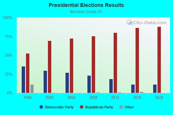
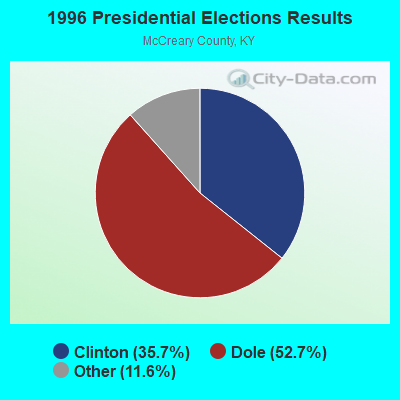

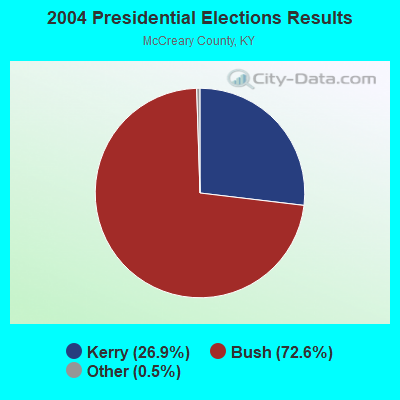

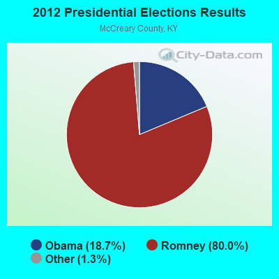

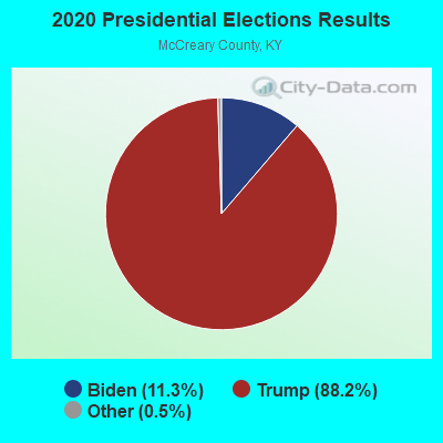
Graphs represent county-level data. Detailed 2008 Election Results
Religion statistics for Parkers Lake, KY (based on McCreary County data)
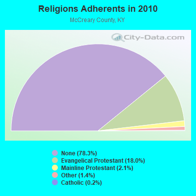
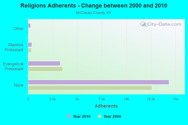
| Religion | Adherents | Congregations |
|---|---|---|
| Evangelical Protestant | 3,287 | 18 |
| Mainline Protestant | 391 | 4 |
| Other | 249 | 1 |
| Catholic | 42 | 1 |
| None | 14,337 | - |
Food Environment Statistics:
| McCreary County: | 2.31 / 10,000 pop. |
| State: | 2.19 / 10,000 pop. |
| This county: | 2.31 / 10,000 pop. |
| Kentucky: | 0.74 / 10,000 pop. |
| Here: | 7.52 / 10,000 pop. |
| State: | 4.36 / 10,000 pop. |
| McCreary County: | 4.63 / 10,000 pop. |
| State: | 5.74 / 10,000 pop. |
| Here: | 12.0% |
| Kentucky: | 11.0% |
| McCreary County: | 33.6% |
| State: | 30.0% |
| Here: | 20.1% |
| Kentucky: | 15.9% |
Strongest AM radio stations in Parkers Lake:
- WEKC (710 AM; daytime; 4 kW; WILLIAMSBURG, KY; Owner: GERALD PARKS)
- WKVL (850 AM; daytime; 50 kW; KNOXVILLE, TN; Owner: HORNE RADIO, LLC)
- WKDP (1330 AM; 5 kW; CORBIN, KY; Owner: EUBANKS BROADCASTING, INC.)
- WEZJ (1440 AM; 2 kW; WILLIAMSBURG, KY; Owner: WHITLEY BROADCASTING CO., INC.)
- WHAS (840 AM; 50 kW; LOUISVILLE, KY; Owner: CLEAR CHANNEL BROADCASTING LICENSES, INC.)
- WSM (650 AM; 50 kW; NASHVILLE, TN; Owner: GAYLORD ENTERTAINMENT COMPANY)
- WCTT (680 AM; 1 kW; CORBIN, KY; Owner: ENCORE COMMUNICATIONS, INC)
- WWAM (820 AM; daytime; 50 kW; JASPER, TN; Owner: SHELTON BROADCASTING SYSTEM)
- WQBB (1040 AM; daytime; 10 kW; POWELL, TN; Owner: JOURNAL BROADCAST CORPORATION)
- WFLI (1070 AM; 50 kW; LOOKOUT MOUNTAIN, TN; Owner: WFLI, INC.)
- WNOX (990 AM; 10 kW; KNOXVILLE, TN)
- WAMB (1160 AM; 50 kW; DONELSON, TN; Owner: GREAT SOUTHERN BROADCASTING COMPANY, INC.)
- WKLB (1290 AM; 5 kW; MANCHESTER, KY; Owner: BARKER BROADCASTING COMPANY, INC.)
Strongest FM radio stations in Parkers Lake:
- WEKX (102.7 FM; JELLICO, TN; Owner: WHITLEY BROADCASTING CO., INC.)
- WHAY (105.9 FM; WHITLEY CITY, KY; Owner: TIM LAVENDER)
- WEZJ-FM (104.3 FM; WILLIAMSBURG, KY; Owner: WHITLEY BROADCASTING CO., INC.)
- WSEK (97.1 FM; SOMERSET, KY; Owner: CAPSTAR TX LIMITED PARTNERSHIP)
- WDVX (89.9 FM; CLINTON, TN; Owner: CUMBERLAND COMMUNITIES COMMUNI CORP.)
- WTHL (90.5 FM; SOMERSET, KY; Owner: SOMERSET EDUCATIONAL BROADCASTING FOUNDATION)
- WMIK-FM (92.7 FM; MIDDLESBORO, KY; Owner: GATEWAY BROADCASTING, INC.)
- WMKZ (93.1 FM; MONTICELLO, KY; Owner: MONTICELLO-WAYNE COUNTY MEDIA, INC.)
- WYGE (92.3 FM; LONDON, KY; Owner: ETHEL HUFF BROADCASTING, LLC)
- WKYM (101.7 FM; MONTICELLO, KY; Owner: STEPHEN W. STAPLES JR.)
- WCTT-FM (107.3 FM; CORBIN, KY; Owner: ENCORE COMMUNICATIONS, INC.)
- WKDP-FM (99.5 FM; CORBIN, KY; Owner: EUBANKS BROADCASTING, INC.)
- WLLK (93.9 FM; BURNSIDE, KY; Owner: CAPSTAR TX LIMITED PARTNERSHIP)
- WVCT (91.5 FM; KEAVY, KY; Owner: VICTORY TRAINING SCHOOL CORP.)
- WRIL (106.3 FM; PINEVILLE, KY; Owner: PINE HILLS BROADCASTING, INC.)
- WKII-FM (102.3 FM; SOMERSET, KY; Owner: CAPSTAR TX LIMITED PARTNERSHIP)
- W277AA (103.3 FM; SOMERSET, KY; Owner: WESTERN KENTUCKY UNIVERSITY)
TV broadcast stations around Parkers Lake:
- WKSO-TV (Channel 29; SOMERSET, KY; Owner: KENTUCKY AUTHORITY FOR EDUCATIONAL TV)
- WVTN-LP (Channel 48; CORBIN, KY; Owner: VICTORY TRAINING SCHOOL CORP.)
- W39CK (Channel 20; CORBIN, KY; Owner: DEREK RAY EUBANKS)

FCC Registered Cell Phone Towers:
2 (See the full list of FCC Registered Cell Phone Towers in Parkers Lake)FCC Registered Antenna Towers:
25 (See the full list of FCC Registered Antenna Towers)FCC Registered Broadcast Land Mobile Towers:
1- Us 27 Falls Rd At Parkers Lake (Lat: 36.726472 Lon: -84.470778), Type: Tank, Structure height: 31 m, Overall height: 38 m, Call Sign: WPOX759,
Assigned Frequencies: 155.190 MHz, Grant Date: 08/13/2014, Expiration Date: 08/26/2024, Certifier: Roger Honeycutt, Registrant: Universal Licensing Service, 4401-A Connecticut Ave Nw #232, Washington, DC 20008, Phone: (877) 677-3639, Email:
FCC Registered Microwave Towers:
5- Greenwood, 1301 Liz Worley Circle (Lat: 36.899611 Lon: -84.513917), Type: Gtower, Structure height: 103.6 m, Overall height: 106.4 m, Call Sign: WQSC296,
Assigned Frequencies: 11305.0 MHz, 11425.0 MHz, Grant Date: 07/25/2023, Expiration Date: 08/29/2033, Certifier: John E Monday, Registrant: At&t Services, Inc., 208 S Akard St, 20f, Dallas, TX 75202, Phone: (855) 699-7073, Email:
- PARKERS LAKE, 165 Hwy 90 (Lat: 36.840861 Lon: -84.478944), Type: Ltower, Structure height: 76.2 m, Overall height: 79.6 m, Call Sign: WQSY289,
Assigned Frequencies: 11385.0 MHz, 11545.0 MHz, 11225.0 MHz, 11265.0 MHz, 11505.0 MHz, 11625.0 MHz, 11305.0 MHz, 11345.0 MHz, Grant Date: 11/07/2023, Expiration Date: 12/09/2033, Certifier: John Monday, Registrant: At&t Services, Inc., 208 S Akard St, 20f, Dallas, TX 75202, Phone: (855) 699-7073, Email:
- 9LV3604A, 165 Hwy 90 (Ky13162-A) (Lat: 36.840861 Lon: -84.478944), Type: Ltower, Structure height: 76.2 m, Overall height: 79.6 m, Call Sign: WRAD500,
Assigned Frequencies: 11465.0 MHz, 11465.0 MHz, 11465.0 MHz, 11465.0 MHz, 11465.0 MHz, 11465.0 MHz, 11465.0 MHz, 11465.0 MHz, Grant Date: 10/17/2017, Expiration Date: 10/17/2027, Cancellation Date: 04/06/2023, Certifier: David Werblow, Registrant: T-Mobile Usa, Inc., 12920 Se 38th Street, Bellevue, WA 98006, Phone: (425) 383-8401, Fax: (425) 383-4040, Email:
- CUMBERLAND FALLS, Cumberland Falls, 750 Herman Vanover Road (Lat: 36.839167 Lon: -84.347583), Type: Mtower, Structure height: 39.6 m, Overall height: 41.1 m, Call Sign: WRPW804,
Assigned Frequencies: 11325.0 MHz, 11325.0 MHz, 11325.0 MHz, 11325.0 MHz, 11325.0 MHz, 11485.0 MHz, 11485.0 MHz, 11485.0 MHz, 11485.0 MHz, 11485.0 MHz, Grant Date: 03/27/2022, Expiration Date: 03/27/2032, Certifier: Christophe Le Scanve, Registrant: Cellco Partnership, 5055 Northpointe Pkwy, Alpharetta, GA 30022, Phone: (770) 797-1070, Email:
- PARKERS LAKE, 165 Hwy 90 (Ky13162-A) (Lat: 36.840861 Lon: -84.478944), Type: Ltower, Structure height: 76.2 m, Overall height: 79.6 m, Call Sign: WRPW853,
Assigned Frequencies: 11245.0 MHz, 11245.0 MHz, 11245.0 MHz, 11245.0 MHz, 11245.0 MHz, Grant Date: 03/28/2022, Expiration Date: 03/28/2032, Certifier: Christophe Le Scanve, Registrant: Cellco Partnership, 5055 Northpointe Pkwy, Alpharetta, GA 30022, Phone: (770) 797-1070, Email:
2002 - 2018 National Fire Incident Reporting System (NFIRS) incidents
- Fire incident types reported to NFIRS in Parkers Lake, KY
- 13443.5%Outside Fires
- 11838.3%Structure Fires
- 4414.3%Mobile Property/Vehicle Fires
- 123.9%Other
 Based on the data from the years 2002 - 2018 the average number of fire incidents per year is 18. The highest number of reported fires - 45 took place in 2007, and the least - 0 in 2011. The data has an increasing trend.
 When looking into fire subcategories, the most reports belonged to: Outside Fires (43.5%), and Structure Fires (38.3%).
- 43.4%Electricity
- 20.4%Wood
- 16.5%Bottled, tank, or LP gas
- 16.3%Fuel oil, kerosene, etc.
- 2.6%Coal or coke
- 0.8%Other fuel

- 51.4%Electricity
- 20.2%Bottled, tank, or LP gas
- 14.5%Wood
- 10.4%Fuel oil, kerosene, etc.
- 3.5%No fuel used
Parkers Lake compared to Kentucky state average:
- Median household income below state average.
- Median house value significantly below state average.
- Black race population percentage significantly below state average.
- Hispanic race population percentage significantly below state average.
- Median age below state average.
- Foreign-born population percentage significantly below state average.
- Renting percentage below state average.
- Length of stay since moving in significantly above state average.
- Number of rooms per house significantly below state average.
- House age significantly below state average.
- Percentage of population with a bachelor's degree or higher significantly below state average.
Parkers Lake on our top lists:
- #19 on the list of "Top 101 cities with the largest percentage of people in homes for the mentally ill (population 1,000+)"
- #26 on the list of "Top 101 cities with the largest percentage of people in homes for abused, dependent, and neglected children (population 1,000+)"
- #37 (42634) on the list of "Top 101 zip codes with the lowest 2012 average taxable interest for individuals (pop 1,000+)"
- #27 on the list of "Top 101 counties with the smallest number of children under 18 without health insurance coverage in 2000"
- #37 on the list of "Top 101 counties with the smallest number of people without health insurance coverage in 2000"