Co-operative, Kentucky
Submit your own pictures of this place and show them to the world
- OSM Map
- Google Map
- MSN Map
| Males: 570 | |
| Females: 544 |
| Median resident age: | 33.7 years |
| Kentucky median age: | 35.9 years |
Zip code: 42647
| Co-operative: | $34,141 |
| KY: | $59,341 |
Estimated per capita income in 2022: $11,878 (it was $6,644 in 2000)
Co-operative CCD income, earnings, and wages data
Estimated median house or condo value in 2022: $52,987 (it was $20,500 in 2000)
| Co-operative: | $52,987 |
| KY: | $196,300 |
Detailed information about poverty and poor residents in Co-operative, KY


- 1,05798.8%White alone
- 90.8%Hispanic
- 30.3%Two or more races
- 10.09%Other race alone

Races in Co-operative detailed stats: ancestries, foreign born residents, place of birth
 Recent articles from our blog. Our writers, many of them Ph.D. graduates or candidates, create easy-to-read articles on a wide variety of topics.
Current Local Time: EST time zone
Land area: 122.9 square miles.
Population density: 9.1 people per square mile (very low).
| Co-operative CCD: | 1.0% ($199) |
| Kentucky: | 0.8% ($610) |
Nearest city with pop. 50,000+: Knoxville, TN  (62.9 miles , pop. 173,890).
Nearest city with pop. 200,000+: Fayette, KY (91.7 miles , pop. 260,512).
Nearest city with pop. 1,000,000+: Chicago, IL (391.2 miles , pop. 2,896,016).
Nearest cities:
), ), ), ), Latitude: 36.71 N, Longitude: 84.61 W

| Here: | 5.4% |
| Kentucky: | 3.8% |

- Wood products (17.9%)
- Transportation equipment (11.1%)
- Educational services (10.8%)
- Construction (10.4%)
- Health care (7.5%)
- Machinery (5.7%)
- Agriculture, forestry, fishing & hunting (4.7%)

- Wood products (26.5%)
- Construction (15.3%)
- Transportation equipment (14.8%)
- Machinery (8.5%)
- Agriculture, forestry, fishing & hunting (6.9%)
- Mining, quarrying, oil & gas extraction (5.3%)
- Truck transportation (5.3%)

- Educational services (33.3%)
- Health care (23.3%)
- Miscellaneous manufacturing (6.7%)
- Retail florists (5.6%)
- Public administration (5.6%)
- Data processing, libraries, other information services (5.6%)
- Apparel (4.4%)

- Other production occupations, including supervisors (16.5%)
- Driver/sales workers and truck drivers (11.1%)
- Building and grounds cleaning and maintenance occupations (8.6%)
- Woodworkers (7.9%)
- Textile, apparel, and furnishings workers (5.7%)
- Other material moving workers, except laborers (5.4%)
- Other office and administrative support workers, including supervisors (5.0%)

- Other production occupations, including supervisors (22.2%)
- Driver/sales workers and truck drivers (13.8%)
- Woodworkers (11.6%)
- Other material moving workers, except laborers (7.9%)
- Building and grounds cleaning and maintenance occupations (7.4%)
- Electrical equipment mechanics and other installation, maintenance, and repair workers, including supervisors (6.9%)
- Metal workers and plastic workers (6.9%)

- Textile, apparel, and furnishings workers (17.8%)
- Other office and administrative support workers, including supervisors (15.6%)
- Nursing, psychiatric, and home health aides (11.1%)
- Building and grounds cleaning and maintenance occupations (11.1%)
- Preschool, kindergarten, elementary, and middle school teachers (10.0%)
- Bus drivers (7.8%)
- Other healthcare support occupations (6.7%)
Average climate in Co-operative, Kentucky
Based on data reported by over 4,000 weather stations


Tornado activity:
Co-operative-area historical tornado activity is slightly below Kentucky state average. It is 5% greater than the overall U.S. average.
On 4/3/1974, a category F4 (max. wind speeds 207-260 mph) tornado 5.2 miles away from the Co-operative place center .
On 4/3/1974, a category F4 tornado 16.1 miles away from the place center killed 5 people and injured 6 people and caused between $500,000 and $5,000,000 in damages.
Earthquake activity:
Co-operative-area historical earthquake activity is significantly above Kentucky state average. It is 96% greater than the overall U.S. average.On 7/27/1980 at 18:52:21, a magnitude 5.2 (5.1 MB, 4.7 MS, 5.0 UK, 5.2 UK, Class: Moderate, Intensity: VI - VII) earthquake occurred 109.8 miles away from the city center
On 4/18/2008 at 09:36:59, a magnitude 5.4 (5.1 MB, 4.8 MS, 5.4 MW, 5.2 MW) earthquake occurred 216.5 miles away from the city center
On 11/30/1973 at 07:48:41, a magnitude 4.7 (4.7 MB, 4.6 ML, Class: Light, Intensity: IV - V) earthquake occurred 72.4 miles away from Co-operative center
On 8/9/2020 at 12:07:37, a magnitude 5.1 (5.1 MW, Depth: 4.7 mi) earthquake occurred 195.8 miles away from the city center
On 4/18/2008 at 09:36:59, a magnitude 5.2 (5.2 MW, Depth: 8.9 mi) earthquake occurred 216.5 miles away from the city center
On 4/29/2003 at 08:59:39, a magnitude 4.9 (4.4 MB, 4.6 MW, 4.9 LG) earthquake occurred 163.5 miles away from the city center
Magnitude types: regional Lg-wave magnitude (LG), body-wave magnitude (MB), local magnitude (ML), surface-wave magnitude (MS), moment magnitude (MW)
Natural disasters:
The number of natural disasters in McCreary County (13) is near the US average (15).Major Disasters (Presidential) Declared: 7
Emergencies Declared: 2
Causes of natural disasters: Storms: 5, Floods: 4, Fires: 2, Landslides: 2, Mudslides: 2, Tornadoes: 2, Winter Storms: 2, Blizzard: 1, Freeze: 1, Hurricane: 1, Snow: 1, Snowfall: 1, Wind: 1, Other: 1 (Note: some incidents may be assigned to more than one category).
Colleges/universities with over 2000 students nearest to Co-operative:
- Somerset Community College (about 25 miles; Somerset, KY; Full-time enrollment: 4,698)
- University of the Cumberlands (about 25 miles; Williamsburg, KY; FT enrollment: 3,585)
- Lindsey Wilson College (about 48 miles; Columbia, KY; FT enrollment: 2,552)
- Lincoln Memorial University (about 54 miles; Harrogate, TN; FT enrollment: 3,706)
- Roane State Community College (about 58 miles; Harriman, TN; FT enrollment: 4,302)
- Pellissippi State Community College (about 58 miles; Knoxville, TN; FT enrollment: 7,271)
- Campbellsville University (about 61 miles; Campbellsville, KY; FT enrollment: 2,948)
Points of interest:
Notable locations in Co-operative: Hemlock Grove Camping Area (A), Bell Farm (B), Wolf Ridge Lookover (C), Bell Farm Horse Camp (D), Great Meadow Campground (E), Hemlock Grove Picnic Area (F), Rattlesnake Ridge Fire Station (G), Wolfe Ridge Fire Station (H). Display/hide their locations on the map
Churches in Co-operative include: Beech Grove Church (A), Wolf Ridge Church (B), Wilson Ridge Church (C), Pleasant Ridge Church (D), Jones Church (E), Hickory Knob Church (F), Freedom Chapel (G). Display/hide their locations on the map
Cemeteries: Phillips Cemetery (1), Nancy Grave Cemetery (2), King Cemetery (3), Kidd Cemetery (4), Jones Cemetery (5), Hill Cemetery (6), Gregory Cemetery (7). Display/hide their locations on the map
Streams, rivers, and creeks: Burkes Branch (A), Cabin Branch (B), Corder Creek (C), Cowhorn Creek (D), Difficulty Creek (E), Dolen Branch (F), Grassy Fork (G), Jim Branch (H), Jones Branch (I). Display/hide their locations on the map
| This place: | 2.6 people |
| Kentucky: | 2.5 people |
| This place: | 74.5% |
| Whole state: | 66.9% |
| This place: | 4.1% |
| Whole state: | 6.4% |
Likely homosexual households (counted as self-reported same-sex unmarried-partner households)
- Lesbian couples: 1.0% of all households
- Gay men: 0.0% of all households
| This place: | 34.2% |
| Whole state: | 15.8% |
| This place: | 14.1% |
| Whole state: | 6.6% |
For population 15 years and over in Co-operative:

- Never married: 16.0%
- Now married: 75.3%
- Separated: 0.6%
- Widowed: 4.2%
- Divorced: 4.4%
For population 25 years and over in Co-operative:
- High school or higher: 33.7%
- Bachelor's degree or higher: 2.0%
- Graduate or professional degree: 0.8%
- Unemployed: 13.1%
- Mean travel time to work (commute): 48.5 minutes


| Here: | 21.4 |
| Kentucky average: | 13.8 |
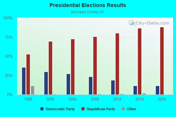
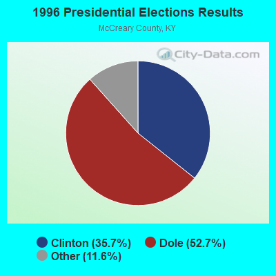

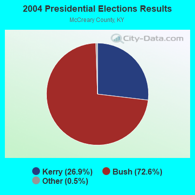

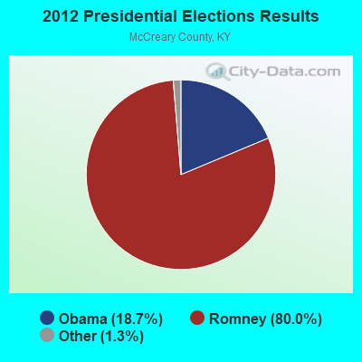

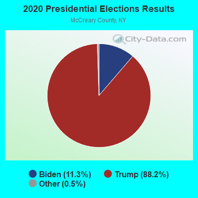
Graphs represent county-level data. Detailed 2008 Election Results
Religion statistics for Co-operative, KY (based on McCreary County data)
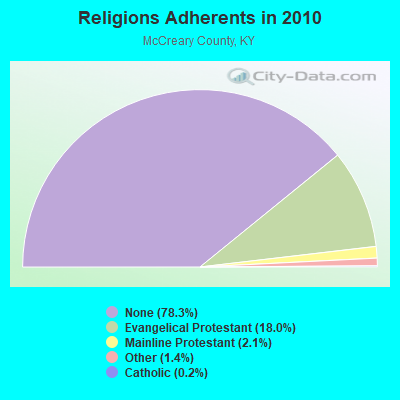
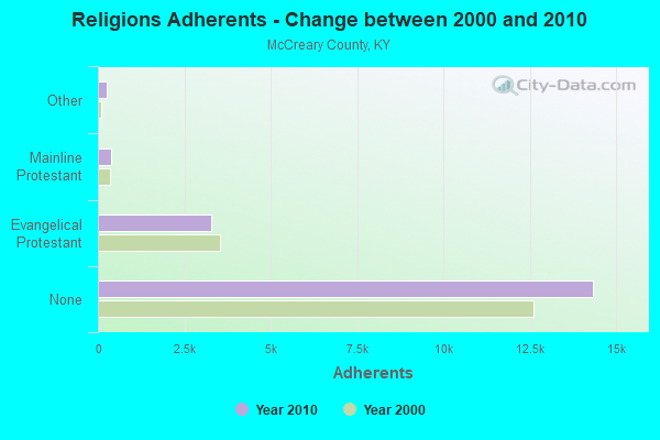
| Religion | Adherents | Congregations |
|---|---|---|
| Evangelical Protestant | 3,287 | 18 |
| Mainline Protestant | 391 | 4 |
| Other | 249 | 1 |
| Catholic | 42 | 1 |
| None | 14,337 | - |
Food Environment Statistics:
| Here: | 2.31 / 10,000 pop. |
| Kentucky: | 2.19 / 10,000 pop. |
| McCreary County: | 2.31 / 10,000 pop. |
| Kentucky: | 0.74 / 10,000 pop. |
| McCreary County: | 7.52 / 10,000 pop. |
| State: | 4.36 / 10,000 pop. |
| Here: | 4.63 / 10,000 pop. |
| Kentucky: | 5.74 / 10,000 pop. |
| This county: | 12.0% |
| State: | 11.0% |
| McCreary County: | 33.6% |
| State: | 30.0% |
| McCreary County: | 20.1% |
| Kentucky: | 15.9% |
Strongest AM radio stations in Co-operative:
- WKVL (850 AM; daytime; 50 kW; KNOXVILLE, TN; Owner: HORNE RADIO, LLC)
- WEKC (710 AM; daytime; 4 kW; WILLIAMSBURG, KY; Owner: GERALD PARKS)
- WHAS (840 AM; 50 kW; LOUISVILLE, KY; Owner: CLEAR CHANNEL BROADCASTING LICENSES, INC.)
- WSM (650 AM; 50 kW; NASHVILLE, TN; Owner: GAYLORD ENTERTAINMENT COMPANY)
- WWAM (820 AM; daytime; 50 kW; JASPER, TN; Owner: SHELTON BROADCASTING SYSTEM)
- WKDP (1330 AM; 5 kW; CORBIN, KY; Owner: EUBANKS BROADCASTING, INC.)
- WOCV (1310 AM; 1 kW; ONEIDA, TN; Owner: ONEIDA BROADCASTERS, INC.)
- WFLI (1070 AM; 50 kW; LOOKOUT MOUNTAIN, TN; Owner: WFLI, INC.)
- WQBB (1040 AM; daytime; 10 kW; POWELL, TN; Owner: JOURNAL BROADCAST CORPORATION)
- WECO (940 AM; 5 kW; WARTBURG, TN; Owner: MORGAN COUNTY B/CASTING CO.)
- WAMB (1160 AM; 50 kW; DONELSON, TN; Owner: GREAT SOUTHERN BROADCASTING COMPANY, INC.)
- WNOX (990 AM; 10 kW; KNOXVILLE, TN)
- WFLW (1360 AM; 1 kW; MONTICELLO, KY; Owner: STEPHEN W. STAPLES, JR.)
Strongest FM radio stations in Co-operative:
- WHAY (105.9 FM; WHITLEY CITY, KY; Owner: TIM LAVENDER)
- WMKZ (93.1 FM; MONTICELLO, KY; Owner: MONTICELLO-WAYNE COUNTY MEDIA, INC.)
- WKYM (101.7 FM; MONTICELLO, KY; Owner: STEPHEN W. STAPLES JR.)
- WEKX (102.7 FM; JELLICO, TN; Owner: WHITLEY BROADCASTING CO., INC.)
- WDVX (89.9 FM; CLINTON, TN; Owner: CUMBERLAND COMMUNITIES COMMUNI CORP.)
- WEZJ-FM (104.3 FM; WILLIAMSBURG, KY; Owner: WHITLEY BROADCASTING CO., INC.)
- WMIK-FM (92.7 FM; MIDDLESBORO, KY; Owner: GATEWAY BROADCASTING, INC.)
- WOKI-FM (100.3 FM; OAK RIDGE, TN; Owner: OAK RIDGE FM, INC.)
- WSEK (97.1 FM; SOMERSET, KY; Owner: CAPSTAR TX LIMITED PARTNERSHIP)
- WECO-FM (101.3 FM; WARTBURG, TN; Owner: MORGAN COUNTY BROADCASTING CO., INC.)
- WTHL (90.5 FM; SOMERSET, KY; Owner: SOMERSET EDUCATIONAL BROADCASTING FOUNDATION)
- WDEB-FM (103.9 FM; JAMESTOWN, TN; Owner: BAZ BROADCASTING, INC.)
TV broadcast stations around Co-operative:
- WKSO-TV (Channel 29; SOMERSET, KY; Owner: KENTUCKY AUTHORITY FOR EDUCATIONAL TV)

- 54.1%Wood
- 30.5%Electricity
- 9.1%Fuel oil, kerosene, etc.
- 3.1%Utility gas
- 3.1%Bottled, tank, or LP gas

- 51.7%Wood
- 31.0%Electricity
- 17.2%Bottled, tank, or LP gas
Co-operative compared to Kentucky state average:
- Median household income below state average.
- Median house value significantly below state average.
- Black race population percentage significantly below state average.
- Hispanic race population percentage significantly below state average.
- Median age below state average.
- Foreign-born population percentage significantly below state average.
- Renting percentage below state average.
- Length of stay since moving in significantly above state average.
- Number of rooms per house significantly below state average.
- House age significantly below state average.
- Number of college students significantly below state average.
- Percentage of population with a bachelor's degree or higher significantly below state average.
Co-operative on our top lists:
- #88 on the list of "Top 100 cities with longest commuting times"
- #90 on the list of "Top 100 least-educated cities"
- #27 on the list of "Top 101 counties with the smallest number of children under 18 without health insurance coverage in 2000"
- #37 on the list of "Top 101 counties with the smallest number of people without health insurance coverage in 2000"