Oxford, Connecticut

Submit your own pictures of this town and show them to the world
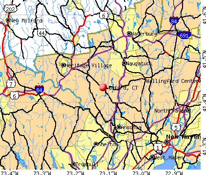
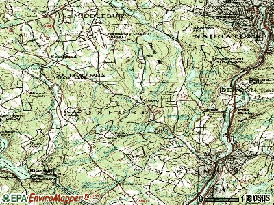
- OSM Map
- General Map
- Google Map
- MSN Map
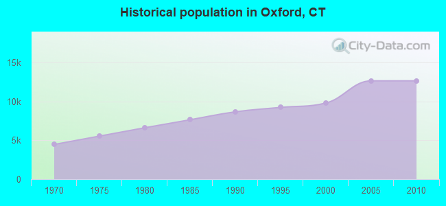
Population change since 2000: +29.1%
| Males: 6,307 | |
| Females: 6,376 |
| Median resident age: | 43.4 years |
| Connecticut median age: | 39.2 years |
Zip codes: 06478.
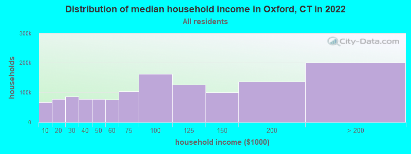
| Oxford: | $126,452 |
| CT: | $88,429 |
Estimated per capita income in 2022: $50,656 (it was $28,250 in 2000)
Oxford town income, earnings, and wages data
Estimated median house or condo value in 2022: $453,349 (it was $209,700 in 2000)
| Oxford: | $453,349 |
| CT: | $347,200 |
Mean prices in 2022: all housing units: $339,332; detached houses: $370,621; townhouses or other attached units: $220,634; in 2-unit structures: $230,566; in 3-to-4-unit structures: $204,968; in 5-or-more-unit structures: $169,619; mobile homes: $83,839
Detailed information about poverty and poor residents in Oxford, CT


- 11,74592.6%White alone
- 4683.7%Hispanic
- 1951.5%Asian alone
- 1341.1%Black alone
- 1080.9%Two or more races
- 130.1%American Indian alone
- 170.1%Other race alone
- 30.02%Native Hawaiian and Other
Pacific Islander alone
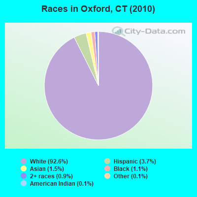
Races in Oxford detailed stats: ancestries, foreign born residents, place of birth
According to our research of Connecticut and other state lists, there were 7 registered sex offenders living in Oxford, Connecticut as of May 23, 2024.
The ratio of all residents to sex offenders in Oxford is 1,812 to 1.
The ratio of registered sex offenders to all residents in this city is much lower than the state average.
 Recent articles from our blog. Our writers, many of them Ph.D. graduates or candidates, create easy-to-read articles on a wide variety of topics.

Latest news from Oxford, CT collected exclusively by city-data.com from local newspapers, TV, and radio stations
Oxford, CT City Guides:
Ancestries: Italian (24.4%), Irish (21.7%), German (16.0%), Polish (13.0%), English (12.0%), United States (4.1%).
Current Local Time: EST time zone
Incorporated on 10/1798
Elevation: 351 feet
Land area: 32.9 square miles.
Population density: 386 people per square mile (very low).
405 residents are foreign born (3.3% Europe, 0.4% Asia).
| This town: | 4.1% |
| Connecticut: | 10.9% |
| Oxford town: | 1.6% ($3,336) |
| Connecticut: | 1.8% ($2,961) |
Nearest city with pop. 50,000+: Waterbury, CT  (10.0 miles , pop. 107,271).
Nearest city with pop. 200,000+: North Hempstead, NY (53.1 miles , pop. 222,611).
Nearest city with pop. 1,000,000+: Bronx, NY (55.9 miles , pop. 1,332,650).
Nearest cities:
), ), )Latitude: 41.43 N, Longitude: 73.13 W
Area code commonly used in this area: 203

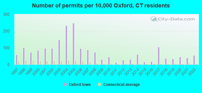
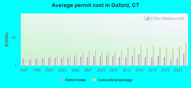
Single-family new house construction building permits:
- 2022: 55 buildings, average cost: $217,500
- 2021: 39 buildings, average cost: $136,900
- 2020: 45 buildings, average cost: $117,300
- 2019: 34 buildings, average cost: $160,300
- 2018: 36 buildings, average cost: $181,000
- 2017: 104 buildings, average cost: $152,800
- 2016: 19 buildings, average cost: $150,000
- 2015: 16 buildings, average cost: $207,400
- 2014: 61 buildings, average cost: $167,800
- 2013: 31 buildings, average cost: $155,700
- 2012: 27 buildings, average cost: $156,300
- 2011: 13 buildings, average cost: $176,800
- 2010: 45 buildings, average cost: $186,500
- 2009: 31 buildings, average cost: $167,100
- 2008: 74 buildings, average cost: $170,800
- 2007: 86 buildings, average cost: $156,800
- 2006: 95 buildings, average cost: $171,200
- 2005: 245 buildings, average cost: $165,300
- 2004: 229 buildings, average cost: $146,200
- 2003: 145 buildings, average cost: $142,500
- 2002: 96 buildings, average cost: $149,000
- 2001: 97 buildings, average cost: $148,900
- 2000: 84 buildings, average cost: $137,300
- 1999: 74 buildings, average cost: $118,900
- 1998: 100 buildings, average cost: $113,200
- 1997: 59 buildings, average cost: $132,800
| Here: | 3.0% |
| Connecticut: | 3.9% |
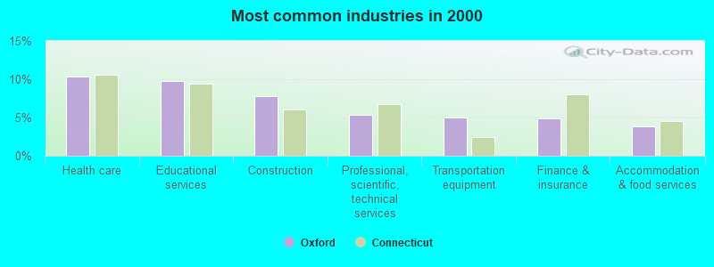
- Health care (10.3%)
- Educational services (9.7%)
- Construction (7.8%)
- Professional, scientific, technical services (5.3%)
- Transportation equipment (4.9%)
- Finance & insurance (4.9%)
- Accommodation & food services (3.8%)
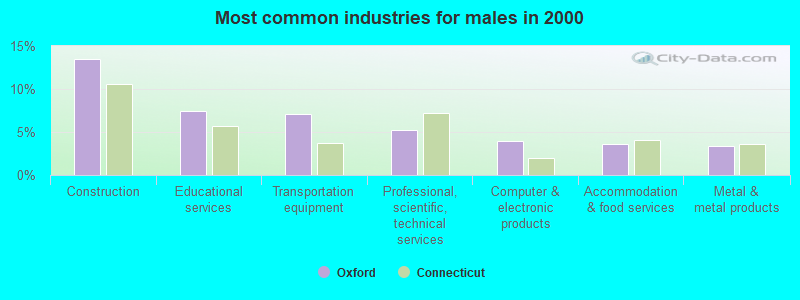
- Construction (13.4%)
- Educational services (7.4%)
- Transportation equipment (7.1%)
- Professional, scientific, technical services (5.2%)
- Computer & electronic products (4.0%)
- Accommodation & food services (3.7%)
- Metal & metal products (3.4%)
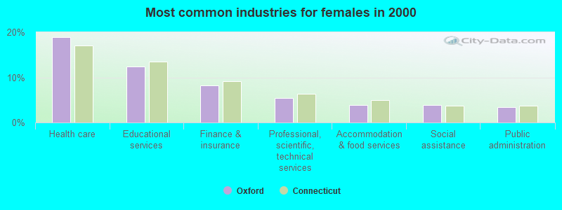
- Health care (19.0%)
- Educational services (12.5%)
- Finance & insurance (8.2%)
- Professional, scientific, technical services (5.5%)
- Accommodation & food services (4.0%)
- Social assistance (3.9%)
- Public administration (3.4%)
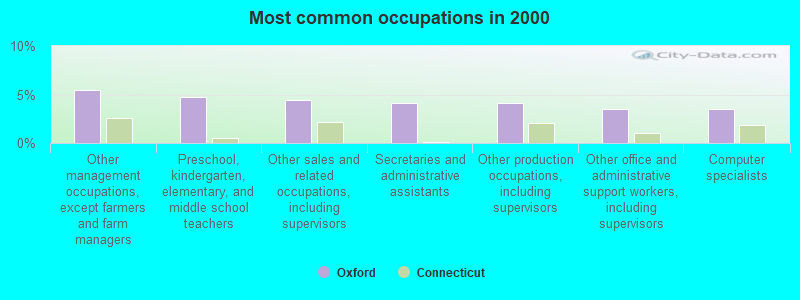
- Other management occupations, except farmers and farm managers (5.5%)
- Preschool, kindergarten, elementary, and middle school teachers (4.7%)
- Other sales and related occupations, including supervisors (4.4%)
- Secretaries and administrative assistants (4.1%)
- Other production occupations, including supervisors (4.1%)
- Other office and administrative support workers, including supervisors (3.5%)
- Computer specialists (3.5%)
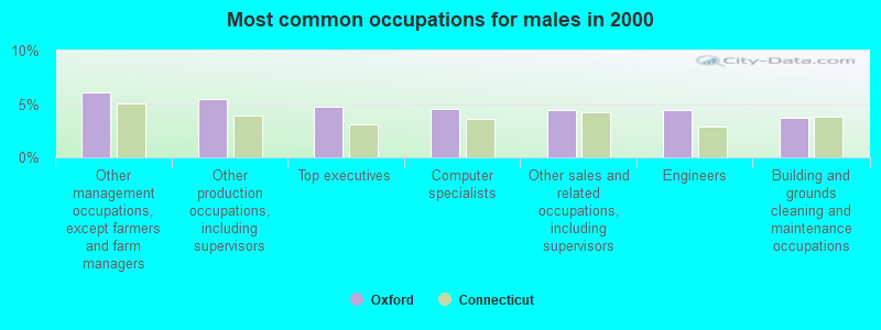
- Other management occupations, except farmers and farm managers (6.1%)
- Other production occupations, including supervisors (5.5%)
- Top executives (4.7%)
- Computer specialists (4.5%)
- Other sales and related occupations, including supervisors (4.5%)
- Engineers (4.4%)
- Building and grounds cleaning and maintenance occupations (3.8%)
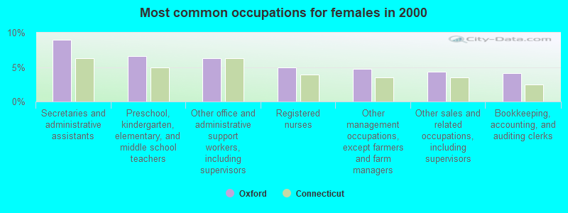
- Secretaries and administrative assistants (9.0%)
- Preschool, kindergarten, elementary, and middle school teachers (6.6%)
- Other office and administrative support workers, including supervisors (6.3%)
- Registered nurses (5.0%)
- Other management occupations, except farmers and farm managers (4.7%)
- Other sales and related occupations, including supervisors (4.4%)
- Bookkeeping, accounting, and auditing clerks (4.2%)
Average climate in Oxford, Connecticut
Based on data reported by over 4,000 weather stations


(lower is better)
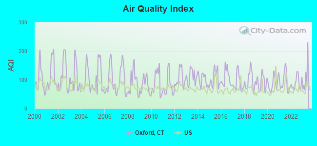
Air Quality Index (AQI) level in 2022 was 88.6. This is worse than average.
| City: | 88.6 |
| U.S.: | 72.6 |
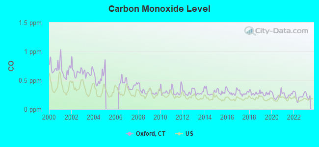
Carbon Monoxide (CO) [ppm] level in 2022 was 0.223. This is about average. Closest monitor was 9.5 miles away from the city center.
| City: | 0.223 |
| U.S.: | 0.251 |
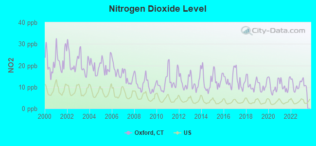
Nitrogen Dioxide (NO2) [ppb] level in 2022 was 10.8. This is significantly worse than average. Closest monitor was 5.7 miles away from the city center.
| City: | 10.8 |
| U.S.: | 5.1 |
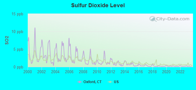
Sulfur Dioxide (SO2) [ppb] level in 2022 was 0.217. This is significantly better than average. Closest monitor was 5.7 miles away from the city center.
| City: | 0.217 |
| U.S.: | 1.515 |
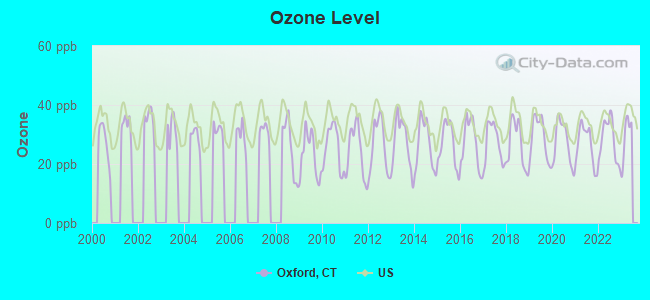
Ozone [ppb] level in 2022 was 28.2. This is about average. Closest monitor was 8.0 miles away from the city center.
| City: | 28.2 |
| U.S.: | 33.3 |
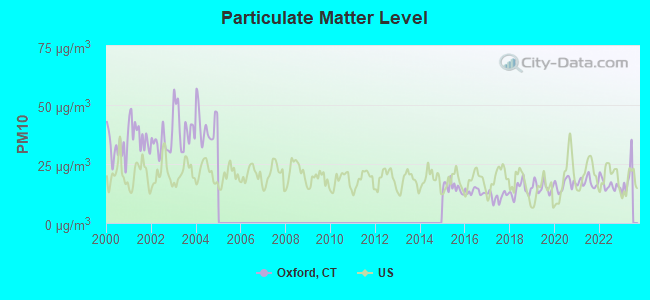
Particulate Matter (PM10) [µg/m3] level in 2022 was 16.2. This is about average. Closest monitor was 6.8 miles away from the city center.
| City: | 16.2 |
| U.S.: | 19.2 |

Particulate Matter (PM2.5) [µg/m3] level in 2022 was 7.57. This is about average. Closest monitor was 9.5 miles away from the city center.
| City: | 7.57 |
| U.S.: | 8.11 |
Tornado activity:
Oxford-area historical tornado activity is near Connecticut state average. It is 30% smaller than the overall U.S. average.
On 7/10/1989, a category F4 (max. wind speeds 207-260 mph) tornado 12.3 miles away from the Oxford town center injured 40 people and caused between $50,000,000 and $500,000,000 in damages.
On 5/24/1962, a category F3 (max. wind speeds 158-206 mph) tornado 8.4 miles away from the town center killed one person and injured 50 people and caused between $500,000 and $5,000,000 in damages.
Earthquake activity:
Oxford-area historical earthquake activity is significantly above Connecticut state average. It is 70% smaller than the overall U.S. average.On 10/7/1983 at 10:18:46, a magnitude 5.3 (5.1 MB, 5.3 LG, 5.1 ML, Class: Moderate, Intensity: VI - VII) earthquake occurred 185.2 miles away from the city center
On 4/20/2002 at 10:50:47, a magnitude 5.3 (5.3 ML, Depth: 3.0 mi) earthquake occurred 215.3 miles away from the city center
On 4/20/2002 at 10:50:47, a magnitude 5.2 (5.2 MB, 4.2 MS, 5.2 MW, 5.0 MW) earthquake occurred 213.7 miles away from Oxford center
On 8/23/2011 at 17:51:04, a magnitude 5.8 (5.8 MW, Depth: 3.7 mi) earthquake occurred 353.1 miles away from the city center
On 1/19/1982 at 00:14:42, a magnitude 4.7 (4.5 MB, 4.7 MD, 4.5 LG, Class: Light, Intensity: IV - V) earthquake occurred 163.1 miles away from the city center
On 1/16/1994 at 01:49:16, a magnitude 4.6 (4.6 MB, 4.6 LG, Depth: 3.1 mi) earthquake occurred 170.1 miles away from Oxford center
Magnitude types: regional Lg-wave magnitude (LG), body-wave magnitude (MB), duration magnitude (MD), local magnitude (ML), surface-wave magnitude (MS), moment magnitude (MW)
Natural disasters:
The number of natural disasters in New Haven County (26) is a lot greater than the US average (15).Major Disasters (Presidential) Declared: 15
Emergencies Declared: 11
Causes of natural disasters: Storms: 7, Hurricanes: 6, Floods: 5, Snowstorms: 5, Winter Storms: 4, Blizzards: 3, Snows: 3, Snowfall: 1, Tornado: 1, Tropical Storm: 1, Wind: 1 (Note: some incidents may be assigned to more than one category).
Hospitals and medical centers in Oxford:
Other hospitals and medical centers near Oxford:
- ALTERNATIVES: FIELDSTONE (Hospital, about 4 miles away; NAUGATUCK, CT)
- ALTERNATIVES: YORKTOWN (Hospital, about 5 miles away; NAUGATUCK, CT)
- SHADY KNOLL (Nursing Home, about 5 miles away; SEYMOUR, CT)
- ALL ABOUT YOU HOME CARE SERVIC (Home Health Center, about 6 miles away; NAUGATUCK, CT)
- GLENDALE CENTER (Nursing Home, about 6 miles away; NAUGATUCK, CT)
- RIVER GLEN HEALTH CARE CTR (Nursing Home, about 7 miles away; SOUTHBURY, CT)
- BIRMINGHAM HEALTH CENTER (Nursing Home, about 7 miles away; DERBY, CT)
Airports located in Oxford:
- Waterbury-Oxford Airport (OXC) (Runways: 1, Air Taxi Ops: 3,914, Itinerant Ops: 24,017, Local Ops: 18,725, Military Ops: 1,331)
Amtrak stations near Oxford:
- 14 miles: NEW HAVEN (50 UNION AVE.) . Services: ticket office, partially wheelchair accessible, enclosed waiting area, public restrooms, public payphones, snack bar, ATM, paid short-term parking, paid long-term parking, car rental agency, taxi stand, intercity bus service, public transit connection.
- 16 miles: WALLINGFORD (37 HALL AVE.) . Services: partially wheelchair accessible, enclosed waiting area, public payphones, free short-term parking, call for car rental service, call for taxi service.
- 18 miles: BRIDGEPORT (525 WATER ST.) . Services: fully wheelchair accessible, enclosed waiting area, public restrooms, public payphones, snack bar, paid short-term parking, paid long-term parking, call for car rental service, taxi stand, intercity bus service, public transit connection.
Colleges/universities with over 2000 students nearest to Oxford:
- Post University (about 8 miles; Waterbury, CT; Full-time enrollment: 5,808)
- Naugatuck Valley Community College (about 9 miles; Waterbury, CT; FT enrollment: 4,491)
- University of Connecticut-Tri-Campus (about 10 miles; Waterbury, CT; FT enrollment: 2,250)
- Southern Connecticut State University (about 12 miles; New Haven, CT; FT enrollment: 8,708)
- Quinnipiac University (about 13 miles; Hamden, CT; FT enrollment: 8,153)
- University of New Haven (about 13 miles; West Haven, CT; FT enrollment: 6,205)
- Yale University (about 14 miles; New Haven, CT; FT enrollment: 13,121)
Public elementary/middle schools in Oxford:
- QUAKER FARMS SCHOOL (Students: 691, Location: 30 GREAT OAK ROAD, Grades: PK-2)
- OXFORD CENTER SCHOOL (Students: 505, Location: 462 OXFORD ROAD, Grades: 3-5)
- GREAT OAK SCHOOL (Students: 339, Location: 50 GREAT OAK ROAD, Grades: 6-8)
Points of interest:
Notable locations in Oxford: Camp Palmer (A), Oxford Town Hall (B), Oxford Public Library (C), Oxford Ambulance Association (D), Oxford Volunteer Fire Department Riverside Company (E), Oxford Volunteer Fire Department Quaker Farms Company (F), Oxford Volunteer Fire Department Center Company (G). Display/hide their locations on the map
Shopping Center: Little River Shopping Center (1). Display/hide its location on the map
Churches in Oxford include: Oxford United Church of Christ (A), Saint Peters Church (B), Christ Church (C), Great Hills United Methodist Church (D), Saint Thomas Church (E). Display/hide their locations on the map
Cemeteries: Brookside Cemetery (1), Southford Cemetery (2), Jacks Hill Cemetery (3), Hillside Cemetery (4). Display/hide their locations on the map
Lakes and reservoirs: Chanko Pond (A), Towantic Pond (B), Nichols Pond (C), Seymour Reservoir Number 2 (D), Seymour Reservoir Number 3 (E), Seymour Reservoir Number 4 (F), Reservoir Number 3 (G), Reservoir Number 2 (H). Display/hide their locations on the map
Streams, rivers, and creeks: Riggs Street Brook (A), Sevenmile Brook (B), Sixmile Brook (C), Eightmile Brook (D), Walnut Hill Brook (E), Fivemile Brook (F), Towantic Brook (G), Jacks Brook (H), Jeremy Brook (I). Display/hide their locations on the map
Parks in Oxford include: Victory Memorial Park (1), Kettletown State Park (2), Southford Falls State Park (3), Jackson Cove Park (4). Display/hide their locations on the map
Tourist attractions: Seymour Fish & Game Club (Recreation Areas; 130 Chestnut Tree Hill R) (1), High Flyin' Fun House Rentals (Arcades & Amusements; 19 Good Hill Road) (2), E S P Group Tours LLC (Tours & Charters; 12 Pine Street) (3). Display/hide their approximate locations on the map
Birthplace of: Leverett Candee - Rubber manufacturer.
| This town: | 2.8 people |
| Connecticut: | 2.5 people |
| This town: | 81.5% |
| Whole state: | 66.3% |
| This town: | 4.6% |
| Whole state: | 6.6% |
Likely homosexual households (counted as self-reported same-sex unmarried-partner households)
- Lesbian couples: 0.4% of all households
- Gay men: 0.2% of all households
| This town: | 2.1% |
| Whole state: | 7.9% |
| This town: | 1.6% |
| Whole state: | 3.9% |
Banks with branches in Oxford (2011 data):
- Naugatuck Savings Bank: Oxford Branch at 71 Oxford Road, Route 67, branch established on 1974/11/25. Info updated 2009/08/17: Bank assets: $915.6 mil, Deposits: $741.6 mil, headquarters in Naugatuck, CT, positive income, Commercial Lending Specialization, 20 total offices
- Webster Bank, National Association: Oxford Branch at 60 Oxford Road, branch established on 1989/07/05. Info updated 2008/12/23: Bank assets: $18,674.3 mil, Deposits: $13,861.5 mil, headquarters in Waterbury, CT, positive income, Commercial Lending Specialization, 167 total offices, Holding Company: Webster Financial Corporation
For population 15 years and over in Oxford:
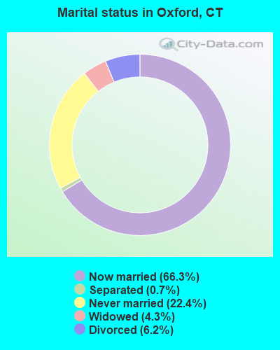
- Never married: 22.4%
- Now married: 66.3%
- Separated: 0.7%
- Widowed: 4.3%
- Divorced: 6.2%
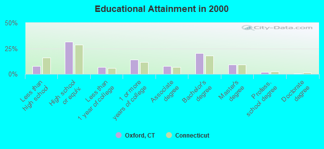
For population 25 years and over in Oxford:
- High school or higher: 92.3%
- Bachelor's degree or higher: 32.2%
- Graduate or professional degree: 11.8%
- Unemployed: 3.1%
- Mean travel time to work (commute): 28.9 minutes
| Here: | 9.8 |
| Connecticut average: | 12.8 |
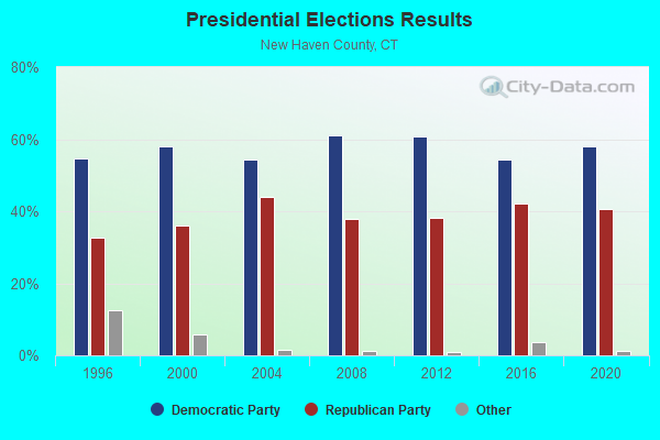
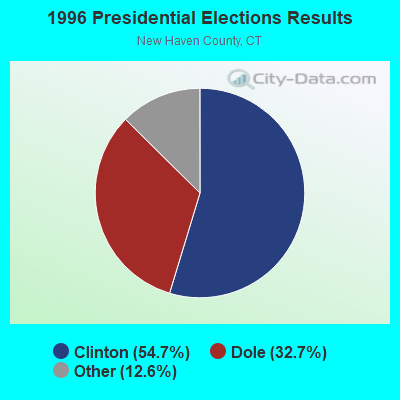
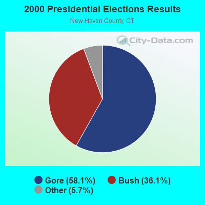
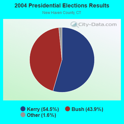
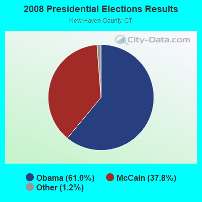
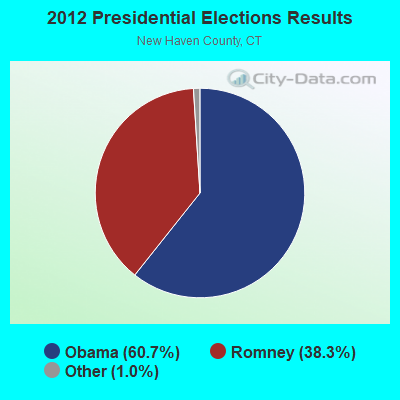
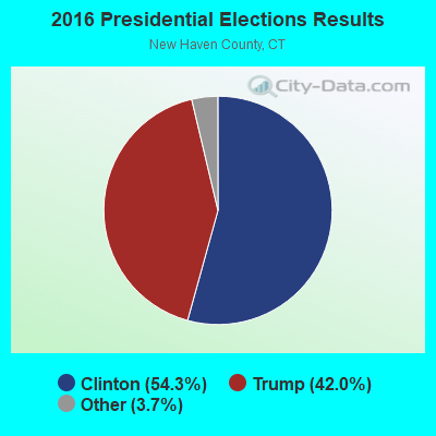
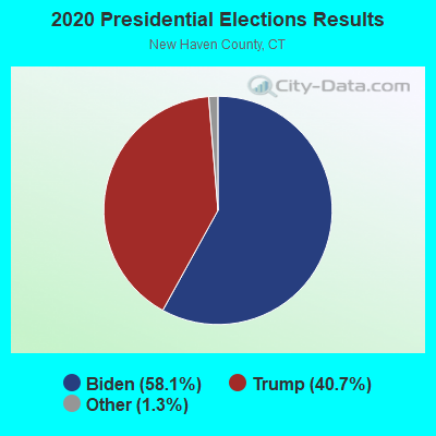
Graphs represent county-level data. Detailed 2008 Election Results
Religion statistics for Oxford, CT (based on New Haven County data)
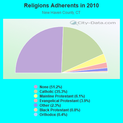
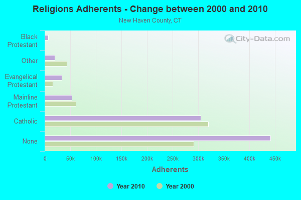
| Religion | Adherents | Congregations |
|---|---|---|
| Catholic | 304,677 | 104 |
| Mainline Protestant | 52,851 | 149 |
| Evangelical Protestant | 33,484 | 208 |
| Other | 19,943 | 79 |
| Black Protestant | 6,471 | 35 |
| Orthodox | 3,731 | 11 |
| None | 441,320 | - |
Food Environment Statistics:
| This county: | 2.04 / 10,000 pop. |
| Connecticut: | 2.21 / 10,000 pop. |
| New Haven County: | 0.08 / 10,000 pop. |
| State: | 0.07 / 10,000 pop. |
| New Haven County: | 1.14 / 10,000 pop. |
| State: | 1.02 / 10,000 pop. |
| New Haven County: | 2.20 / 10,000 pop. |
| Connecticut: | 2.27 / 10,000 pop. |
| Here: | 9.05 / 10,000 pop. |
| Connecticut: | 9.19 / 10,000 pop. |
| New Haven County: | 8.2% |
| Connecticut: | 7.3% |
| New Haven County: | 24.0% |
| Connecticut: | 21.5% |
| New Haven County: | 15.4% |
| Connecticut: | 15.8% |
5.40% of this county's 2021 resident taxpayers lived in other counties in 2020 ($78,288 average adjusted gross income)
| Here: | 5.40% |
| Connecticut average: | 5.79% |
0.02% of residents moved from foreign countries ($112 average AGI)
New Haven County: 0.02% Connecticut average: 0.02%
Top counties from which taxpayers relocated into this county between 2020 and 2021:
| from Fairfield County, CT | |
| from Hartford County, CT | |
| from Middlesex County, CT |
5.51% of this county's 2020 resident taxpayers moved to other counties in 2021 ($77,261 average adjusted gross income)
| Here: | 5.51% |
| Connecticut average: | 5.82% |
0.01% of residents moved to foreign countries ($54 average AGI)
New Haven County: 0.01% Connecticut average: 0.02%
Top counties to which taxpayers relocated from this county between 2020 and 2021:
| to Hartford County, CT | |
| to Fairfield County, CT | |
| to Middlesex County, CT |
| Businesses in Oxford, CT | ||||
| Name | Count | Name | Count | |
|---|---|---|---|---|
| Decora Cabinetry | 2 | MasterBrand Cabinets | 3 | |
| Dunkin Donuts | 1 | Subway | 1 | |
| FedEx | 3 | |||
Strongest AM radio stations in Oxford:
- WADS (690 AM; daytime; 3 kW; ANSONIA, CT; Owner: RADIO AMOR, INC.)
- WFNW (1380 AM; 5 kW; NAUGATUCK, CT; Owner: CANDIDO DIAS CARRELO)
- WTIC (1080 AM; 50 kW; HARTFORD, CT; Owner: INFINITY RADIO OPERATIONS INC.)
- WATR (1320 AM; 5 kW; WATERBURY, CT; Owner: WATR, INC.)
- WELI (960 AM; 5 kW; NEW HAVEN, CT; Owner: CLEAR CHANNEL BROADCASTING LICENSES, INC.)
- WFAN (660 AM; 50 kW; NEW YORK, NY; Owner: INFINITY BROADCASTING OPERATIONS, INC.)
- WNNZ (640 AM; 50 kW; WESTFIELD, MA; Owner: CLEAR CHANNEL BROADCASTING LICENSES, INC.)
- WCBS (880 AM; 50 kW; NEW YORK, NY; Owner: INFINITY BROADCASTING OPERATIONS, INC.)
- WGSM (740 AM; 25 kW; HUNTINGTON, NY; Owner: K RADIO LICENSEE, INC.)
- WMCA (570 AM; 50 kW; NEW YORK, NY; Owner: SALEM MEDIA OF NEW YORK, LLC)
- WABC (770 AM; 50 kW; NEW YORK, NY; Owner: WABC-AM RADIO, INC.)
- WOR (710 AM; 50 kW; NEW YORK, NY; Owner: BUCKLEY BROADCASTING CORPORATION)
- WFIF (1500 AM; daytime; 5 kW; MILFORD, CT)
Strongest FM radio stations in Oxford:
- WRXC (90.1 FM; SHELTON, CT; Owner: MONROE BOARD OF EDUCATION)
- WKCI-FM (101.3 FM; HAMDEN, CT; Owner: CLEAR CHANNEL BROADCASTING LICENSES, INC.)
- WPLR (99.1 FM; NEW HAVEN, CT; Owner: COX RADIO, INC.)
- WEZN-FM (99.9 FM; BRIDGEPORT, CT; Owner: CXR HOLDINGS, INC.)
- WSHU-FM (91.1 FM; FAIRFIELD, CT; Owner: SACRED HEART UNIVERSITY, INC.)
- WYBC-FM (94.3 FM; NEW HAVEN, CT; Owner: YALE BROADCASTING CO., INC.)
- WPKN (89.5 FM; BRIDGEPORT, CT; Owner: WPKN, INC.)
- WWYZ (92.5 FM; WATERBURY, CT; Owner: CAPSTAR TX LIMITED PARTNERSHIP)
- WKSS (95.7 FM; HARTFORD-MERIDEN, CT; Owner: CAPSTAR TX LIMITED PARTNERSHIP)
- WZMX (93.7 FM; HARTFORD, CT; Owner: INFINITY RADIO OPERATIONS INC.)
- WHCN (105.9 FM; HARTFORD, CT; Owner: CAPSTAR TX LIMITED PARTNERSHIP)
- WMRQ (104.1 FM; WATERBURY, CT; Owner: CAPSTAR TX LIMITED PARTNERSHIP)
- WMNR (88.1 FM; MONROE, CT; Owner: MONROE BOARD OF EDUCATION)
- WPKT (90.5 FM; MERIDEN, CT; Owner: CONNECTICUT PUBLIC BROADCASTING, INC)
- WDRC-FM (102.9 FM; HARTFORD, CT; Owner: BUCKLEY BROADCASTING CORPORATION)
- WRCH (100.5 FM; NEW BRITAIN, CT; Owner: INFINITY RADIO OPERATIONS INC.)
- WMNR-FM1 (88.1 FM; HUNTINGTON, CT; Owner: MONROE BOARD OF EDUCATION)
- WRKI (95.1 FM; BROOKFIELD, CT; Owner: CUMULUS LICENSING CORP.)
- WDAQ (98.3 FM; DANBURY, CT; Owner: BERKSHIRE BROADCASTING CORP.)
- W226AG (93.1 FM; HAMDEN, CT; Owner: SAINT THOMAS SEMINARY)
TV broadcast stations around Oxford:
- WTNH (Channel 8; NEW HAVEN, CT; Owner: WTNH BROADCASTING, INC.)
- WCTX (Channel 59; NEW HAVEN, CT; Owner: WTNH BROADCASTING, INC.)
- WEDY (Channel 65; NEW HAVEN, CT; Owner: CONNECTICUT PUBLIC BROADCASTING, INC.)
- WSAH (Channel 43; BRIDGEPORT, CT; Owner: WSAH LICENSE, INC.)
- WTIC-TV (Channel 61; HARTFORD, CT; Owner: TRIBUNE TELEVISION COMPANY)
- W11BJ (Channel 11; HARTFORD, CT; Owner: COMMUNICATIONS SITE MANAGEMENT LLC)
- WEDW (Channel 49; BRIDGEPORT, CT; Owner: CONNECTICUT PUBLIC BROADCASTING, INC.)
- WTXX (Channel 20; WATERBURY, CT; Owner: WTXX INC.)
- WVIT (Channel 30; NEW BRITAIN, CT; Owner: OUTLET BROADCASTING, INC)
- WEDH (Channel 24; HARTFORD, CT; Owner: CONNECTICUT PUBLIC BROADCASTING, INC.)
- WUVN (Channel 18; HARTFORD, CT; Owner: ENTRAVISION HOLDINGS, LLC)
- W12BH (Channel 12; WATERBURY, CT; Owner: CONN.PUBLIC BROADCASTING, INC.)
- WFSB (Channel 3; HARTFORD, CT; Owner: MEREDITH CORPORATION)
- WHPX (Channel 26; NEW LONDON, CT; Owner: PAXSON HARTFORD LICENSE, INC.)
- W28AJ (Channel 28; ALLINGTOWN, CT; Owner: PAGING ASSOCIATES, INC.)
- W51BZ (Channel 51; NEW HAVEN, CT; Owner: it COMMUNICATIONS, INC.)
- National Bridge Inventory (NBI) Statistics
- 19Number of bridges
- 75ft / 22.6mTotal length
- $2,160,000Total costs
- 251,641Total average daily traffic
- 10,278Total average daily truck traffic
- 373,913Total future (year 2032) average daily traffic
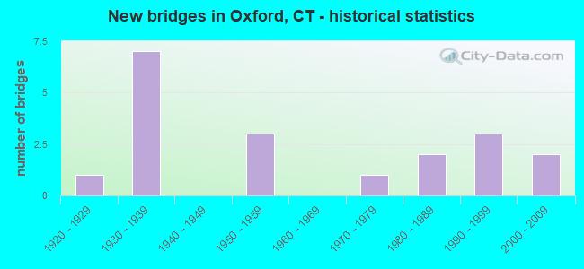
- New bridges - historical statistics
- 11920-1929
- 71930-1939
- 31950-1959
- 11970-1979
- 21980-1989
- 31990-1999
- 22000-2009
FCC Registered Antenna Towers: 32 (See the full list of FCC Registered Antenna Towers)
FCC Registered Broadcast Land Mobile Towers: 10 (See the full list of FCC Registered Broadcast Land Mobile Towers in Oxford, CT)
FCC Registered Microwave Towers: 3 (See the full list of FCC Registered Microwave Towers in this town)
FCC Registered Maritime Coast & Aviation Ground Towers: 15 (See the full list of FCC Registered Maritime Coast & Aviation Ground Towers)
FCC Registered Amateur Radio Licenses: 65 (See the full list of FCC Registered Amateur Radio Licenses in Oxford)
FAA Registered Aircraft Manufacturers and Dealers: 4 (See the full list of FAA Registered Manufacturers and Dealers in Oxford)
FAA Registered Aircraft: 54 (See the full list of FAA Registered Aircraft)
2002 - 2018 National Fire Incident Reporting System (NFIRS) incidents
- Fire incident types reported to NFIRS in Oxford, CT
- 29256.2%Structure Fires
- 13626.2%Outside Fires
- 8115.6%Mobile Property/Vehicle Fires
- 112.1%Other
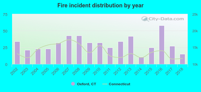 Based on the data from the years 2002 - 2018 the average number of fire incidents per year is 31. The highest number of reported fires - 58 took place in 2016, and the least - 11 in 2014. The data has a dropping trend.
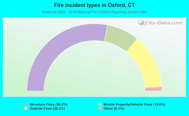 When looking into fire subcategories, the most reports belonged to: Structure Fires (56.2%), and Outside Fires (26.2%).
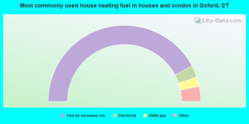
- 84.6%Fuel oil, kerosene, etc.
- 5.0%Electricity
- 4.1%Utility gas
- 3.4%Wood
- 2.7%Bottled, tank, or LP gas
- 0.3%Other fuel
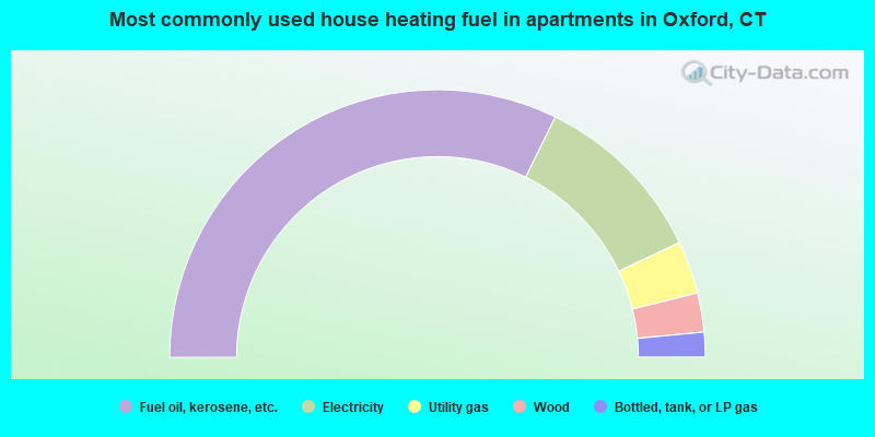
- 64.5%Fuel oil, kerosene, etc.
- 21.4%Electricity
- 6.4%Utility gas
- 4.7%Wood
- 3.0%Bottled, tank, or LP gas
Oxford compared to Connecticut state average:
- Unemployed percentage significantly below state average.
- Black race population percentage significantly below state average.
- Hispanic race population percentage significantly below state average.
- Median age above state average.
- Foreign-born population percentage significantly below state average.
- Renting percentage significantly below state average.
- Length of stay since moving in significantly above state average.
- Number of rooms per house significantly below state average.
- House age significantly below state average.
Oxford on our top lists:
- #18 on the list of "Top 101 cities with largest percentage of males in occupations: preschool, kindergarten, elementary and middle school teachers (population 5,000+)"
- #36 on the list of "Top 101 cities with largest percentage of males in occupations: communications equipment operators (population 5,000+)"
- #44 on the list of "Top 101 cities with largest percentage of females in industries: jewelry, luggage, and leather goods stores (population 5,000+)"
- #62 on the list of "Top 101 cities with largest percentage of females in industries: hardware, plumbing and heating equipment, and supplies merchant wholesalers (population 5,000+)"
- #69 on the list of "Top 101 cities with largest percentage of males in industries: electronic shopping and mail-order houses (population 5,000+)"
- #70 on the list of "Top 101 cities with largest percentage of males in industries: sporting goods, camera, and hobby and toy stores (population 5,000+)"
- #79 on the list of "Top 101 cities with largest percentage of males in occupations: motor vehicle operators except bus and truck drivers (population 5,000+)"
- #79 on the list of "Top 101 cities with largest percentage of females in industries: electrical equipment, appliances, and components (population 5,000+)"
- #86 on the list of "Top 101 cities with largest percentage of males in industries: recyclable material merchant wholesalers (population 5,000+)"
- #87 on the list of "Top 101 cities with largest percentage of females in occupations: supervisors of construction and extraction workers (population 5,000+)"
- #96 on the list of "Top 101 cities with largest percentage of males in industries: transportation equipment (population 5,000+)"
- #97 on the list of "Top 101 cities with largest percentage of females in industries: miscellaneous manufacturing (population 5,000+)"
- #100 on the list of "Top 101 cities with largest percentage of females in industries: motor vehicle and parts dealers (population 5,000+)"
- #7 on the list of "Top 101 counties with highest percentage of residents voting for Obama (Democrat) in the 2012 Presidential Election"
- #14 on the list of "Top 101 counties with the most Catholic congregations"
- #36 on the list of "Top 101 counties with the most Catholic adherents"
- #38 on the list of "Top 101 counties with the lowest percentage of residents that keep firearms around their homes"
- #47 on the list of "Top 101 counties with the highest carbon monoxide air pollution readings in 2012 (ppm)"

|
|
Total of 336 patent applications in 2008-2024.