Milford, Georgia
Submit your own pictures of this place and show them to the world
- OSM Map
- General Map
- Google Map
- MSN Map

| Males: 635 | |
| Females: 686 |
| Median resident age: | 35.5 years |
| Georgia median age: | 33.4 years |
Zip code: 31770
| Milford: | $50,066 |
| GA: | $72,837 |
Estimated per capita income in 2022: $23,545 (it was $16,598 in 2000)
Milford CCD income, earnings, and wages data
Estimated median house or condo value in 2022: $179,000 (it was $61,100 in 2000)
| Milford: | $179,000 |
| GA: | $297,400 |
Mean prices in 2022: all housing units: $148,139; detached houses: $177,115; townhouses or other attached units: $37,711; mobile homes: $75,773
Detailed information about poverty and poor residents in Milford, GA


- 73751.5%White alone
- 66946.8%Black alone
- 141.0%Hispanic
- 60.4%Two or more races
- 40.3%American Indian alone
- 10.07%Native Hawaiian and Other
Pacific Islander alone

Races in Milford detailed stats: ancestries, foreign born residents, place of birth
 Recent articles from our blog. Our writers, many of them Ph.D. graduates or candidates, create easy-to-read articles on a wide variety of topics.
Current Local Time: EST time zone
Land area: 160.8 square miles.
Population density: 8.2 people per square mile (very low).

| Milford CCD: | 0.6% ($365) |
| Georgia: | 0.9% ($919) |
Nearest city with pop. 50,000+: West Dougherty, GA (28.9 miles  , pop. 59,680).
Nearest city with pop. 200,000+: Montgomery, AL (126.0 miles , pop. 201,568).
Nearest city with pop. 1,000,000+: Houston, TX (653.8 miles , pop. 1,953,631).
Nearest cities:
), ), Latitude: 31.29 N, Longitude: 84.55 W
Area code commonly used in this area: 229


| Here: | 3.9% |
| Georgia: | 2.9% |

- Agriculture, forestry, fishing & hunting (19.5%)
- Public administration (10.0%)
- Educational services (7.1%)
- Food (6.6%)
- Construction (5.4%)
- Textile mills & textile products (5.2%)
- Health care (4.7%)

- Agriculture, forestry, fishing & hunting (30.6%)
- Public administration (13.5%)
- Construction (9.5%)
- Textile mills & textile products (5.8%)
- Administrative & support & waste management services (4.0%)
- Truck transportation (3.7%)
- Food (3.4%)

- Educational services (11.9%)
- Food (10.7%)
- Apparel (10.3%)
- Health care (8.7%)
- Sporting goods, camera, hobby & toy stores (6.0%)
- Public administration (5.6%)
- Agriculture, forestry, fishing & hunting (5.2%)

- Farmers and farm managers (7.4%)
- Law enforcement workers, including supervisors (5.7%)
- Other production occupations, including supervisors (5.0%)
- Textile, apparel, and furnishings workers (5.0%)
- Other teachers, instructors, education, training, and library occupations (4.5%)
- Retail sales workers, except cashiers (4.3%)
- Other office and administrative support workers, including supervisors (4.3%)

- Farmers and farm managers (10.4%)
- Law enforcement workers, including supervisors (7.3%)
- Driver/sales workers and truck drivers (7.3%)
- Agricultural workers, including supervisors (6.7%)
- Other office and administrative support workers, including supervisors (6.1%)
- Other material moving workers, except laborers (4.6%)
- Electrical equipment mechanics and other installation, maintenance, and repair workers, including supervisors (4.6%)

- Textile, apparel, and furnishings workers (11.5%)
- Other teachers, instructors, education, training, and library occupations (7.1%)
- Other sales and related occupations, including supervisors (6.0%)
- Other production occupations, including supervisors (6.0%)
- Retail sales workers, except cashiers (5.6%)
- Other management occupations, except farmers and farm managers (5.2%)
- Food processing workers (4.8%)
Average climate in Milford, Georgia
Based on data reported by over 4,000 weather stations


Tornado activity:
Milford-area historical tornado activity is slightly above Georgia state average. It is 47% greater than the overall U.S. average.
On 3/20/2003, a category F3 (max. wind speeds 158-206 mph) tornado 18.1 miles away from the Milford place center killed 6 people and injured 200 people and caused $7 million in damages.
On 2/13/2000, a category F3 tornado 18.3 miles away from the place center killed 11 people and injured 175 people and caused $20 million in damages.
Earthquake activity:
Milford-area historical earthquake activity is significantly above Georgia state average. It is 9% smaller than the overall U.S. average.On 10/24/1997 at 08:35:17, a magnitude 4.9 (4.8 MB, 4.2 MS, 4.9 LG, Depth: 6.2 mi, Class: Light, Intensity: IV - V) earthquake occurred 161.5 miles away from Milford center
On 8/2/1974 at 08:52:09, a magnitude 4.9 (4.3 MB, 4.9 LG) earthquake occurred 215.4 miles away from Milford center
On 4/29/2003 at 08:59:39, a magnitude 4.9 (4.4 MB, 4.6 MW, 4.9 LG) earthquake occurred 230.5 miles away from Milford center
On 1/18/1999 at 07:00:53, a magnitude 4.8 (4.8 MB, 4.0 LG, Depth: 0.6 mi) earthquake occurred 215.6 miles away from the city center
On 4/29/2003 at 08:59:39, a magnitude 4.6 (4.6 MW, Depth: 12.3 mi) earthquake occurred 230.5 miles away from the city center
On 11/22/1974 at 05:25:55, a magnitude 4.7 (4.7 MB) earthquake occurred 281.1 miles away from Milford center
Magnitude types: regional Lg-wave magnitude (LG), body-wave magnitude (MB), surface-wave magnitude (MS), moment magnitude (MW)
Natural disasters:
The number of natural disasters in Baker County (13) is near the US average (15).Major Disasters (Presidential) Declared: 9
Emergencies Declared: 2
Causes of natural disasters: Floods: 6, Storms: 6, Tornadoes: 6, Hurricanes: 2, Tropical Storms: 2, Winds: 2, Drought: 1, Heavy Rain: 1, Other: 1 (Note: some incidents may be assigned to more than one category).
Colleges/universities with over 2000 students nearest to Milford:
- Bainbridge State College (about 27 miles; Bainbridge, GA; Full-time enrollment: 2,308)
- Darton State College (about 29 miles; Albany, GA; FT enrollment: 5,000)
- Albany Technical College (about 29 miles; Albany, GA; FT enrollment: 3,707)
- Albany State University (about 32 miles; Albany, GA; FT enrollment: 3,662)
- George C Wallace State Community College-Dothan (about 55 miles; Dothan, AL; FT enrollment: 3,611)
- Georgia Southwestern State University (about 57 miles; Americus, GA; FT enrollment: 2,689)
- Tallahassee Community College (about 60 miles; Tallahassee, FL; FT enrollment: 10,904)
Points of interest:
Notable locations in Milford: Patmos Community Volunteer Fire Department (A), Ichauway Volunteer Fire Department (B). Display/hide their locations on the map
Churches in Milford include: Patmos Church (A), Bethel Church (B), Christ Church (C), Ichaway Church (D), Live Oak Church (E), Macedonia Church (F), Mount Enon Church (G), New Evergreen Church (H), New Salem Church (I). Display/hide their locations on the map
Cemeteries: Newberry Cemetery (1), Smith Cemetery (2), Stephen Bush Cemetery (3), Morgan Cemetery (4), Mount Pleasant Cemetery (5), Oak Grove Cemetery (6), Notchaway Baptist Church Cemetery (7). Display/hide their locations on the map
Reservoirs and swamps: Rays Pond (A), Thompson Lake (B), Duck Pond (C). Display/hide their locations on the map
Creeks: Keel Creek (A), Spring Creek (B), Ichawaynochaway Creek (C), Caney Creek (D), Alligator Creek (E), Mill Creek (F). Display/hide their locations on the map
| This place: | 2.5 people |
| Georgia: | 2.6 people |
| This place: | 65.7% |
| Whole state: | 68.5% |
| This place: | 5.7% |
| Whole state: | 5.9% |
Likely homosexual households (counted as self-reported same-sex unmarried-partner households)
- Lesbian couples: 0.6% of all households
- Gay men: 0.6% of all households
| This place: | 19.5% |
| Whole state: | 13.0% |
| This place: | 10.1% |
| Whole state: | 6.1% |
For population 15 years and over in Milford:

- Never married: 30.1%
- Now married: 55.1%
- Separated: 3.8%
- Widowed: 8.3%
- Divorced: 6.5%
For population 25 years and over in Milford:
- High school or higher: 67.8%
- Bachelor's degree or higher: 12.1%
- Graduate or professional degree: 3.5%
- Unemployed: 7.1%
- Mean travel time to work (commute): 31.9 minutes


| Here: | 15.3 |
| Georgia average: | 13.3 |
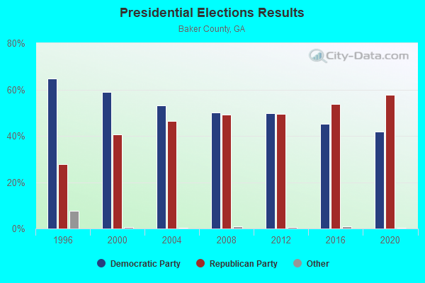
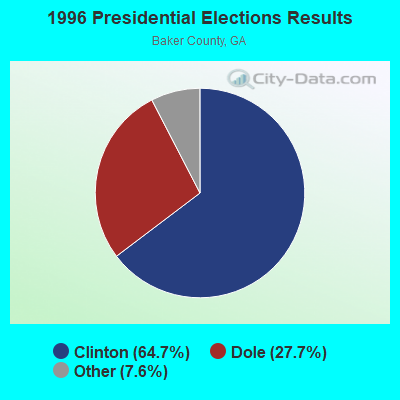
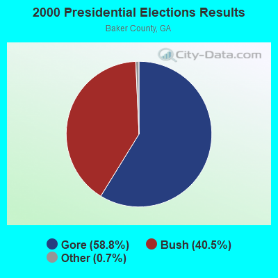

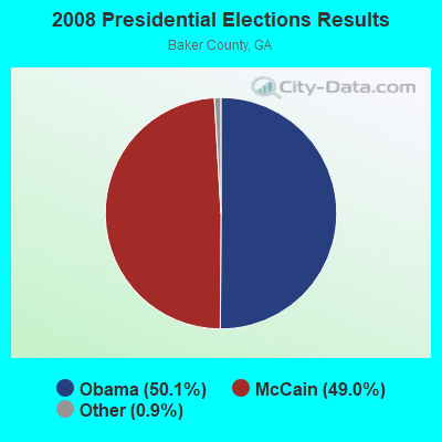
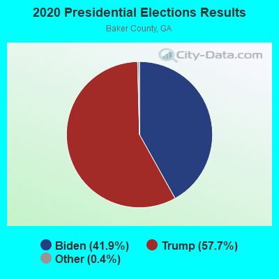
Graphs represent county-level data. Detailed 2008 Election Results
Religion statistics for Milford, GA (based on Baker County data)
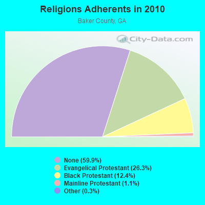
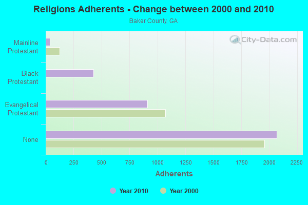
| Religion | Adherents | Congregations |
|---|---|---|
| Evangelical Protestant | 909 | 10 |
| Black Protestant | 427 | 3 |
| Mainline Protestant | 37 | 2 |
| Other | 10 | - |
| Catholic | - | - |
| None | 2,068 | - |
Food Environment Statistics:
| Baker County: | 2.65 / 10,000 pop. |
| Georgia: | 1.91 / 10,000 pop. |
| Baker County: | 2.65 / 10,000 pop. |
| State: | 5.12 / 10,000 pop. |
| Baker County: | 5.30 / 10,000 pop. |
| Georgia: | 7.41 / 10,000 pop. |
| Baker County: | 13.1% |
| Georgia: | 10.4% |
| Baker County: | 32.5% |
| Georgia: | 27.8% |
| Baker County: | 13.4% |
| Georgia: | 14.6% |
Strongest AM radio stations in Milford:
- WSTT (730 AM; 25 kW; THOMASVILLE, GA; Owner: MARION R. WILLIAMS)
- WMGR (930 AM; 5 kW; BAINBRIDGE, GA; Owner: DECATUR BROADCASTING, INC.)
- WJEP (1020 AM; daytime; 10 kW; OCHLOCKNEE, GA; Owner: LIFELINE MINISTRIES, INCORPORATED)
- WJYZ (960 AM; 5 kW; ALBANY, GA; Owner: CLEAR CHANNEL BROADCASTING LICENSES, INC.)
- WHGH (840 AM; daytime; 10 kW; THOMASVILLE, GA; Owner: H. G. H INVESTMENT CORP.)
- WMGA (1130 AM; 10 kW; MOULTRIE, GA; Owner: RADIO MOULTRIE, INC.)
- WOOF (560 AM; 5 kW; DOTHAN, AL; Owner: WOOF, INC.)
- WMAC (940 AM; 50 kW; MACON, GA; Owner: CUMULUS LICENSING CORP.)
- WFVR (910 AM; 50 kW; VALDOSTA, GA; Owner: RAMA COMMUNICATIONS, INC.)
- WTCL (1580 AM; daytime; 10 kW; CHATTAHOOCHEE, FL; Owner: METZ, INC.)
- WALG (1590 AM; 5 kW; ALBANY, GA; Owner: CUMULUS LICENSING CORP.)
- WGST (640 AM; 50 kW; ATLANTA, GA; Owner: CITICASTERS LICENSES, L.P.)
- WFRF (1070 AM; daytime; 10 kW; TALLAHASSEE, FL; Owner: FAITH RADIO NETWORK, INC.)
Strongest FM radio stations in Milford:
- WRAK-FM (97.3 FM; BAINBRIDGE, GA; Owner: CLEAR CHANNEL BROADCASTING LICENSES, INC.)
- WKAK (104.5 FM; ALBANY, GA; Owner: CUMULUS LICENSING CORP.)
- WBBK-FM (93.1 FM; BLAKELY, GA; Owner: MERCHANTS BROADCASTING SYSTEMS OF SW GA)
- WTVY-FM (95.5 FM; DOTHAN, AL; Owner: STYLES BROADCASTING OF DOTHAN, INC.)
- WQVE (105.5 FM; CAMILLA, GA; Owner: CUMULUS LICENSING CORP.)
- WGMK (106.3 FM; DONALSONVILLE, GA; Owner: MERCHANTS BROADCASTING CO)
- WBGE (101.9 FM; BAINBRIDGE, GA; Owner: JOHN H. WIGGINS)
TV broadcast stations around Milford:
- W08DM (Channel 8; COLQUITT, GA; Owner: MS COMMUNICATIONS, LLC)
- W69DO (Channel 69; COLQUITT, GA; Owner: MS COMMUNICATIONS, LLC)
- WABW-TV (Channel 14; PELHAM, GA; Owner: GEORGIA PUBLIC TELECOMMUNICATIONS COMMISSION)
- WTLH (Channel 49; BAINBRIDGE, GA; Owner: WTLH LICENSE CORP.)
- W26BM (Channel 26; COLQUITT, GA; Owner: MS COMMUNICATIONS, LLC)
- W45BL (Channel 45; COLQUITT, GA; Owner: MS COMMUNICATIONS, LLC)
- W51CQ (Channel 51; COLQUITT, GA; Owner: MS COMMUNICATIONS, LLC)
- WTWC-TV (Channel 40; TALLAHASSEE, FL; Owner: WTWC LICENSEE, LLC)
- WCTV (Channel 6; THOMASVILLE, GA; Owner: WCTV LICENSEE CORP.)
- WTXL-TV (Channel 27; TALLAHASSEE, FL; Owner: MEDIA VENTURE MANAGEMENT, INC.)
- W30BO (Channel 30; COLQUITT, GA; Owner: MS COMMUNICATIONS, LLC)
- WALB (Channel 10; ALBANY, GA; Owner: LIBCO, INC.)
- WACS-TV (Channel 25; DAWSON, GA; Owner: GEORGIA PUBLIC TELECOMMUNICATIONS COMMISSION)
- WFXL (Channel 31; ALBANY, GA; Owner: WAITT LICENSE COMPANY OF GEORGIA, L.L.C.)
- W19CP (Channel 19; MOULTRIE, GA; Owner: TIFT AREA TV)
- W34CZ (Channel 34; ALBANY, GA; Owner: TRINITY BROADCASTING NETWORK)
- W47BX (Channel 47; COLQUITT, GA; Owner: MS COMMUNICATIONS, LLC)
- W22BV (Channel 22; COLQUITT, GA; Owner: MS COMMUNICATIONS, LLC)
FCC Registered Cell Phone Towers:
1 (See the full list of FCC Registered Cell Phone Towers in Milford)FCC Registered Antenna Towers:
7 (See the full list of FCC Registered Antenna Towers)FCC Registered Microwave Towers:
2- MILFORD, 2132 Hwy 216 (Lat: 31.388222 Lon: -84.544083), Type: Tower, Structure height: 76.2 m, Overall height: 80.7 m, Call Sign: WPZK585,
Assigned Frequencies: 6256.54 MHz, 6226.89 MHz, Grant Date: 12/24/2013, Expiration Date: 01/30/2024, Cancellation Date: 10/23/2023, Certifier: Richard A Craig, Registrant: Verizon Wireless, 5055 North Point Pkwy, Np2ne Network Engineering, Alpharetta, GA 30022, Phone: (770) 797-1070, Email:
- GE MILFORD, Ll 226 7th Land District Baker County (Lat: 31.388333 Lon: -84.544167), Type: Mast, Structure height: 76.2 m, Overall height: 80.7 m, Call Sign: WQPZ560,
Assigned Frequencies: 6315.84 MHz, Grant Date: 09/27/2012, Expiration Date: 09/27/2022, Cancellation Date: 12/03/2022, Certifier: Chris Harris, Registrant: Conterra Ultra Broadband, LLC, 2101 Rexford Rd, Ste 200e, Charlotte, NC 28211, Phone: (704) 936-1801, Fax: (704) 936-1801, Email:

- 55.0%Electricity
- 41.3%Bottled, tank, or LP gas
- 2.6%Utility gas
- 1.2%Wood

- 72.7%Electricity
- 27.3%Bottled, tank, or LP gas
Milford compared to Georgia state average:
- Median house value below state average.
- Unemployed percentage below state average.
- Hispanic race population percentage significantly below state average.
- Median age below state average.
- Foreign-born population percentage significantly below state average.
- Renting percentage below state average.
- Length of stay since moving in significantly above state average.
- Number of rooms per house significantly below state average.
- House age significantly below state average.
- Number of college students significantly below state average.
- Percentage of population with a bachelor's degree or higher below state average.