Branchville, Georgia
Submit your own pictures of this place and show them to the world
- OSM Map
- General Map
- Google Map
- MSN Map

| Males: 535 | |
| Females: 555 |
| Median resident age: | 38.8 years |
| Georgia median age: | 33.4 years |
Zip code: 31730
| Branchville: | $41,145 |
| GA: | $72,837 |
Estimated per capita income in 2022: $25,533 (it was $13,289 in 2000)
Branchville CCD income, earnings, and wages data
Estimated median house or condo value in 2022: $98,423 (it was $45,900 in 2000)
| Branchville: | $98,423 |
| GA: | $297,400 |
Detailed information about poverty and poor residents in Branchville, GA


- 77971.7%White alone
- 27325.1%Black alone
- 161.5%Hispanic
- 111.0%Two or more races
- 40.4%Asian alone
- 30.3%American Indian alone

Races in Branchville detailed stats: ancestries, foreign born residents, place of birth
 Recent articles from our blog. Our writers, many of them Ph.D. graduates or candidates, create easy-to-read articles on a wide variety of topics.
Current Local Time: EST time zone
Elevation: 140 feet
Land area: 98.5 square miles.
Population density: 11 people per square mile (very low).

| Branchville CCD: | 1.1% ($520) |
| Georgia: | 0.9% ($919) |
Nearest city with pop. 50,000+: West Dougherty, GA (32.2 miles  , pop. 59,680).
Nearest city with pop. 200,000+: Montgomery, AL (139.8 miles , pop. 201,568).
Nearest city with pop. 1,000,000+: Houston, TX (662.5 miles , pop. 1,953,631).
Nearest cities:
), ), ), ), Latitude: 31.14 N, Longitude: 84.38 W
Area code commonly used in this area: 229


| Here: | 3.1% |
| Georgia: | 2.9% |

- Agriculture, forestry, fishing & hunting (24.0%)
- Construction (12.0%)
- Accommodation & food services (6.6%)
- Educational services (5.9%)
- Apparel (4.5%)
- Food (4.1%)
- Personal & laundry services (3.6%)

- Agriculture, forestry, fishing & hunting (38.0%)
- Construction (20.5%)
- Food & beverage stores (5.4%)
- Utilities (5.0%)
- Food (4.3%)
- Textile mills & textile products (4.3%)
- Finance & insurance (3.5%)

- Educational services (14.2%)
- Accommodation & food services (13.1%)
- Apparel (10.9%)
- Personal & laundry services (8.7%)
- Health care (8.2%)
- Furniture & home furnishings, household appliance stores (5.5%)
- Groceries & related products merchant wholesalers (4.9%)

- Farmers and farm managers (12.2%)
- Electrical equipment mechanics and other installation, maintenance, and repair workers, including supervisors (9.1%)
- Driver/sales workers and truck drivers (7.7%)
- Agricultural workers, including supervisors (7.5%)
- Other teachers, instructors, education, training, and library occupations (5.2%)
- Textile, apparel, and furnishings workers (4.5%)
- Other production occupations, including supervisors (4.3%)

- Farmers and farm managers (20.9%)
- Electrical equipment mechanics and other installation, maintenance, and repair workers, including supervisors (15.5%)
- Agricultural workers, including supervisors (10.1%)
- Driver/sales workers and truck drivers (10.1%)
- Top executives (4.7%)
- Other production occupations, including supervisors (4.3%)
- Other financial specialists (3.5%)

- Personal appearance workers (8.7%)
- Other teachers, instructors, education, training, and library occupations (8.7%)
- Textile, apparel, and furnishings workers (8.7%)
- Waiters and waitresses (7.1%)
- Building and grounds cleaning and maintenance occupations (6.0%)
- Preschool, kindergarten, elementary, and middle school teachers (5.5%)
- Art and design workers (5.5%)
Average climate in Branchville, Georgia
Based on data reported by over 4,000 weather stations


Tornado activity:
Branchville-area historical tornado activity is slightly above Georgia state average. It is 42% greater than the overall U.S. average.
On 2/13/2000, a category F3 (max. wind speeds 158-206 mph) tornado 7.0 miles away from the Branchville place center killed 11 people and injured 175 people and caused $20 million in damages.
On 3/20/2003, a category F3 tornado 7.3 miles away from the place center killed 6 people and injured 200 people and caused $7 million in damages.
Earthquake activity:
Branchville-area historical earthquake activity is significantly above Georgia state average. It is 16% smaller than the overall U.S. average.On 10/24/1997 at 08:35:17, a magnitude 4.9 (4.8 MB, 4.2 MS, 4.9 LG, Depth: 6.2 mi, Class: Light, Intensity: IV - V) earthquake occurred 171.0 miles away from the city center
On 8/2/1974 at 08:52:09, a magnitude 4.9 (4.3 MB, 4.9 LG) earthquake occurred 218.9 miles away from Branchville center
On 4/29/2003 at 08:59:39, a magnitude 4.9 (4.4 MB, 4.6 MW, 4.9 LG) earthquake occurred 242.9 miles away from Branchville center
On 1/18/1999 at 07:00:53, a magnitude 4.8 (4.8 MB, 4.0 LG, Depth: 0.6 mi) earthquake occurred 229.6 miles away from Branchville center
On 4/29/2003 at 08:59:39, a magnitude 4.6 (4.6 MW, Depth: 12.3 mi) earthquake occurred 242.9 miles away from the city center
On 11/22/1974 at 05:25:55, a magnitude 4.7 (4.7 MB) earthquake occurred 276.7 miles away from the city center
Magnitude types: regional Lg-wave magnitude (LG), body-wave magnitude (MB), surface-wave magnitude (MS), moment magnitude (MW)
Natural disasters:
The number of natural disasters in Mitchell County (10) is smaller than the US average (15).Major Disasters (Presidential) Declared: 7
Emergencies Declared: 2
Causes of natural disasters: Tornadoes: 6, Floods: 3, Storms: 3, Hurricanes: 2, Drought: 1, Heavy Rain: 1, Tropical Storm: 1, Wind: 1, Other: 1 (Note: some incidents may be assigned to more than one category).
Colleges/universities with over 2000 students nearest to Branchville:
- Bainbridge State College (about 19 miles; Bainbridge, GA; Full-time enrollment: 2,308)
- Albany Technical College (about 32 miles; Albany, GA; FT enrollment: 3,707)
- Darton State College (about 33 miles; Albany, GA; FT enrollment: 5,000)
- Albany State University (about 33 miles; Albany, GA; FT enrollment: 3,662)
- Tallahassee Community College (about 49 miles; Tallahassee, FL; FT enrollment: 10,904)
- Florida State University (about 49 miles; Tallahassee, FL; FT enrollment: 38,283)
- Florida Agricultural and Mechanical University (about 50 miles; Tallahassee, FL; FT enrollment: 10,841)
Points of interest:
Notable location: Hopeful Community Fire Department (A). Display/hide its location on the map
Churches in Branchville include: Antioch Church (A), Branchville Church (B), Freewill Church (C), Greenwood Freewill Baptist Church (D), Hopeful Church (E), Delwood Church (F), Green Grove Church (G), Oak Grove Church (H), Evergreen Church (I). Display/hide their locations on the map
Cemeteries: Turkey Pen Cemetery (1), Union Cemetery (2). Display/hide their locations on the map
Lake: Gee Pond (A). Display/hide its location on the map
Streams, rivers, and creeks: Big Slough (A), Bay Pole Branch (B). Display/hide their locations on the map
| This place: | 2.6 people |
| Georgia: | 2.6 people |
| This place: | 71.2% |
| Whole state: | 68.5% |
| This place: | 5.8% |
| Whole state: | 5.9% |
Likely homosexual households (counted as self-reported same-sex unmarried-partner households)
- Lesbian couples: 0.2% of all households
- Gay men: 0.0% of all households
| This place: | 22.6% |
| Whole state: | 13.0% |
| This place: | 4.9% |
| Whole state: | 6.1% |
For population 15 years and over in Branchville:

- Never married: 17.6%
- Now married: 63.0%
- Separated: 5.1%
- Widowed: 12.1%
- Divorced: 7.2%
For population 25 years and over in Branchville:
- High school or higher: 65.0%
- Bachelor's degree or higher: 6.9%
- Graduate or professional degree: 0.7%
- Unemployed: 6.4%
- Mean travel time to work (commute): 43.7 minutes


| Here: | 18.0 |
| Georgia average: | 13.3 |
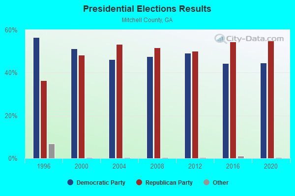
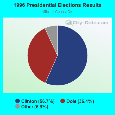
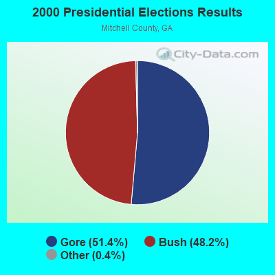
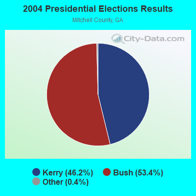
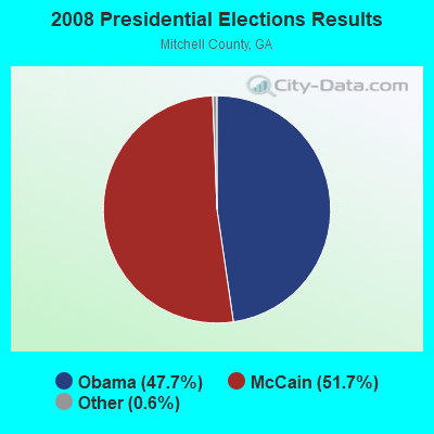
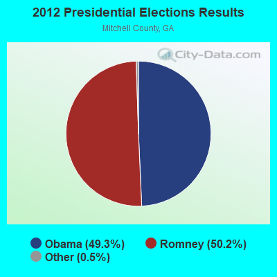
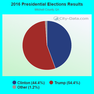
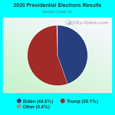
Graphs represent county-level data. Detailed 2008 Election Results
Religion statistics for Branchville, GA (based on Mitchell County data)
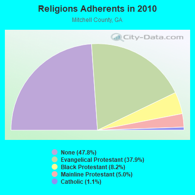
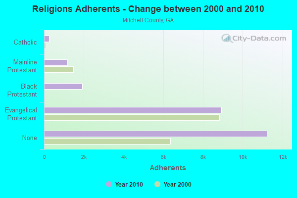
| Religion | Adherents | Congregations |
|---|---|---|
| Evangelical Protestant | 8,911 | 32 |
| Black Protestant | 1,928 | 10 |
| Mainline Protestant | 1,172 | 9 |
| Catholic | 259 | 1 |
| Other | 4 | 1 |
| None | 11,224 | - |
Food Environment Statistics:
| This county: | 5.39 / 10,000 pop. |
| Georgia: | 1.91 / 10,000 pop. |
| Mitchell County: | 1.24 / 10,000 pop. |
| Georgia: | 0.86 / 10,000 pop. |
| Mitchell County: | 8.70 / 10,000 pop. |
| Georgia: | 5.12 / 10,000 pop. |
| Mitchell County: | 4.56 / 10,000 pop. |
| State: | 7.41 / 10,000 pop. |
| This county: | 11.7% |
| Georgia: | 10.4% |
| Here: | 33.3% |
| State: | 27.8% |
| Here: | 12.7% |
| Georgia: | 14.6% |
Strongest AM radio stations in Branchville:
- WSTT (730 AM; 25 kW; THOMASVILLE, GA; Owner: MARION R. WILLIAMS)
- WMGR (930 AM; 5 kW; BAINBRIDGE, GA; Owner: DECATUR BROADCASTING, INC.)
- WJEP (1020 AM; daytime; 10 kW; OCHLOCKNEE, GA; Owner: LIFELINE MINISTRIES, INCORPORATED)
- WHGH (840 AM; daytime; 10 kW; THOMASVILLE, GA; Owner: H. G. H INVESTMENT CORP.)
- WMGA (1130 AM; 10 kW; MOULTRIE, GA; Owner: RADIO MOULTRIE, INC.)
- WFVR (910 AM; 50 kW; VALDOSTA, GA; Owner: RAMA COMMUNICATIONS, INC.)
- WJYZ (960 AM; 5 kW; ALBANY, GA; Owner: CLEAR CHANNEL BROADCASTING LICENSES, INC.)
- WFRF (1070 AM; daytime; 10 kW; TALLAHASSEE, FL; Owner: FAITH RADIO NETWORK, INC.)
- WTCL (1580 AM; daytime; 10 kW; CHATTAHOOCHEE, FL; Owner: METZ, INC.)
- WGRA (790 AM; 1 kW; CAIRO, GA; Owner: LOVETT BROADCASTING ENTERPRISES, INC)
- WMAC (940 AM; 50 kW; MACON, GA; Owner: CUMULUS LICENSING CORP.)
- WOKV (690 AM; 50 kW; JACKSONVILLE, FL; Owner: COX RADIO, INC.)
- WMTM (1300 AM; 5 kW; MOULTRIE, GA; Owner: COLQUITT BROADCASTING COMPANY, LLC)
Strongest FM radio stations in Branchville:
- WRAK-FM (97.3 FM; BAINBRIDGE, GA; Owner: CLEAR CHANNEL BROADCASTING LICENSES, INC.)
- WKAK (104.5 FM; ALBANY, GA; Owner: CUMULUS LICENSING CORP.)
- WKVH (91.9 FM; MONTICELLO, FL; Owner: EDUCATIONAL MEDIA FOUNDATION)
- WFSU-FM (88.9 FM; TALLAHASSEE, FL; Owner: FLORIDA STATE UNIVERSITY)
- WGLF (104.1 FM; TALLAHASSEE, FL; Owner: CUMULUS LICENSING CORP.)
- WWLD (102.3 FM; CAIRO, GA; Owner: CUMULUS LICENSING CORP.)
- WOBB (100.3 FM; TIFTON, GA; Owner: CLEAR CHANNEL BROADCASTING LICENSES, INC.)
- WQVE (105.5 FM; CAMILLA, GA; Owner: CUMULUS LICENSING CORP.)
- WBGE (101.9 FM; BAINBRIDGE, GA; Owner: JOHN H. WIGGINS)
- WTNT-FM (94.9 FM; TALLAHASSEE, FL; Owner: CLEAR CHANNEL BROADCASTING LICENSES, INC.)
- WTLY (107.1 FM; THOMASVILLE, GA; Owner: CLEAR CHANNEL BROADCASTING LICENSES, INC.)
- WZND (105.3 FM; HEADLAND, AL; Owner: GULF SOUTH COMMUNICATIONS, INC.)
TV broadcast stations around Branchville:
- WABW-TV (Channel 14; PELHAM, GA; Owner: GEORGIA PUBLIC TELECOMMUNICATIONS COMMISSION)
- WTLH (Channel 49; BAINBRIDGE, GA; Owner: WTLH LICENSE CORP.)
- WTWC-TV (Channel 40; TALLAHASSEE, FL; Owner: WTWC LICENSEE, LLC)
- WCTV (Channel 6; THOMASVILLE, GA; Owner: WCTV LICENSEE CORP.)
- W19CP (Channel 19; MOULTRIE, GA; Owner: TIFT AREA TV)
- WTXL-TV (Channel 27; TALLAHASSEE, FL; Owner: MEDIA VENTURE MANAGEMENT, INC.)
- W02CE (Channel 2; CAMILLA, GA; Owner: MITCHELL COUNTY TELEVISION)
- WALB (Channel 10; ALBANY, GA; Owner: LIBCO, INC.)
- W08DM (Channel 8; COLQUITT, GA; Owner: MS COMMUNICATIONS, LLC)
- WFXL (Channel 31; ALBANY, GA; Owner: WAITT LICENSE COMPANY OF GEORGIA, L.L.C.)
- W69DO (Channel 69; COLQUITT, GA; Owner: MS COMMUNICATIONS, LLC)
- W26BM (Channel 26; COLQUITT, GA; Owner: MS COMMUNICATIONS, LLC)
- W45BL (Channel 45; COLQUITT, GA; Owner: MS COMMUNICATIONS, LLC)
- W51CQ (Channel 51; COLQUITT, GA; Owner: MS COMMUNICATIONS, LLC)

- 59.8%Electricity
- 38.0%Bottled, tank, or LP gas
- 2.3%Fuel oil, kerosene, etc.

- 74.4%Electricity
- 18.3%Bottled, tank, or LP gas
- 7.3%Wood
Branchville compared to Georgia state average:
- Median household income below state average.
- Median house value significantly below state average.
- Unemployed percentage below state average.
- Hispanic race population percentage significantly below state average.
- Foreign-born population percentage significantly below state average.
- Renting percentage below state average.
- Length of stay since moving in significantly above state average.
- Number of rooms per house significantly below state average.
- House age significantly below state average.
- Number of college students below state average.
- Percentage of population with a bachelor's degree or higher significantly below state average.