Linton, Georgia
Submit your own pictures of this place and show them to the world
- OSM Map
- General Map
- Google Map
- MSN Map

| Males: 482 | |
| Females: 511 |
| Median resident age: | 35.0 years |
| Georgia median age: | 33.4 years |
Zip code: 31087
| Linton: | $37,725 |
| GA: | $72,837 |
Estimated per capita income in 2022: $21,446 (it was $11,698 in 2000)
Linton CCD income, earnings, and wages data
Estimated median house or condo value in 2022: $93,184 (it was $38,400 in 2000)
| Linton: | $93,184 |
| GA: | $297,400 |
Detailed information about poverty and poor residents in Linton, GA
Compare current foreclosures near Linton, GA:
| Photo | Address | Area | Beds / Baths | Price | Details |
|---|---|---|---|---|---|

|
#1
Richmond St
Sandersville, GA 31082
|
2,614 sq. feet
|
2 baths 3 beds |
show details | |

|
#2
Walden Rd
Sandersville, GA 31082
|
3,031 sq. feet
|
3 baths 4 beds |
show details | |

|
#3
Harmony Church Rd
Sandersville, GA 31082
|
2,128 sq. feet
|
2 baths 3 beds |
show details | |

|
#4
Youngblood Rd SE
Milledgeville, GA 31061
|
1,424 sq. feet
|
1 baths 3 beds |
show details | |

|
#5
Hilandale Dr
Milledgeville, GA 31061
|
1,418 sq. feet
|
2 baths 3 beds |
show details | |

|
#6
Ghettis St
Sparta, GA 31087
|
1,458 sq. feet
|
1 baths 3 beds |
show details | |

|
#7
Gordon St
Sparta, GA 31087
|
1,019 sq. feet
|
1 baths 3 beds |
show details | |

|
#8
Fairmont Rd
Sparta, GA 31087
|
1,011 sq. feet
|
2 baths 3 beds |
show details | |

|
#9
Stembridge Rd SE # A
Milledgeville, GA 31061
|
1,216 sq. feet
|
2 baths 2 beds |
show details | |

|
#10
Kings Rd SE
Milledgeville, GA 31061
|
1,658 sq. feet
|
1 baths 2 beds |
show details |
| Photo | Address | Area | Beds / Baths | Price | Details |
|---|---|---|---|---|---|

|
#11
Pine Cone Rd NW
Milledgeville, GA 31061
|
1,568 sq. feet
|
2 baths 3 beds |
show details | |

|
#12
T Tucker Rd
Sparta, GA 31087
|
2,432 sq. feet
|
2 baths 3 beds |
show details | |

|
#13
Jones Chapel Rd
Sparta, GA 31087
|
1,025 sq. feet
|
1 baths 3 beds |
show details | |

|
#14
Columbine Rd
Milledgeville, GA 31061
|
2,001 sq. feet
|
2 baths 3 beds |
show details | |

|
#15
Lovers Ln NE
Milledgeville, GA 31061
|
1,716 sq. feet
|
2 baths 3 beds |
show details | |

|
#16
Old Colony Farm Rd SW
Milledgeville, GA 31061
|
1,728 sq. feet
|
2 baths 3 beds |
show details | |

|
#17
Beulah Hwy
Sparta, GA 31087
|
1,568 sq. feet
|
2 baths - beds |
show details | |

|
#18
Ebony Lounge Rd NE
Milledgeville, GA 31061
|
2,016 sq. feet
|
2 baths 4 beds |
show details | |

|
#19
Waits Rd NW
Milledgeville, GA 31061
|
1,301 sq. feet
|
2 baths 3 beds |
show details | |

|
#20
1st St SW
Milledgeville, GA 31061
|
2,020 sq. feet
|
1 baths - beds |
show details |
| Photo | Address | Area | Beds / Baths | Price | Details |
|---|---|---|---|---|---|

|
#21
Bonner Dr SW
Milledgeville, GA 31061
|
- sq. feet
|
2 baths 2 beds |
show details | |

|
#22
Queens Ct
Milledgeville, GA 31061
|
1,275 sq. feet
|
1 baths - beds |
show details | |

|
#23
Rosewood Dr SE
Milledgeville, GA 31061
|
1,066 sq. feet
|
1 baths - beds |
show details | |

|
#24
Youngblood Rd SE
Milledgeville, GA 31061
|
1,274 sq. feet
|
1 baths - beds |
show details | |

|
#25
Felton Dr
Milledgeville, GA 31061
|
1,448 sq. feet
|
2 baths - beds |
show details | |

|
#26
Magnolia Ave SE
Milledgeville, GA 31061
|
2,778 sq. feet
|
3 baths - beds |
show details | |

|
#27
Perry Dr
Milledgeville, GA 31061
|
1,144 sq. feet
|
1 baths - beds |
show details | |

|
#28
Stuart Cir SE
Milledgeville, GA 31061
|
1,158 sq. feet
|
1 baths - beds |
show details | |

|
#29
Lake Dr # B
Milledgeville, GA 31061
|
1,560 sq. feet
|
2 baths - beds |
show details | |

|
#30
Barrows Ferry Rd NE
Milledgeville, GA 31061
|
1,957 sq. feet
|
2 baths - beds |
show details |
| Photo | Address | Area | Beds / Baths | Price | Details |
|---|---|---|---|---|---|

|
#31
2nd St SW
Milledgeville, GA 31061
|
664 sq. feet
|
1 baths - beds |
show details | |

|
#32
Oak Ave
Milledgeville, GA 31061
|
1,050 sq. feet
|
1 baths - beds |
show details | |

|
#33
Harrisburg Rd SW
Milledgeville, GA 31061
|
1,129 sq. feet
|
2 baths - beds |
show details | |

|
#34
Lilac Dr SE
Milledgeville, GA 31061
|
1,384 sq. feet
|
2 baths - beds |
show details | |

|
#35
Lilac Dr SE
Milledgeville, GA 31061
|
1,510 sq. feet
|
2 baths - beds |
show details | |

|
#36
Irwinton Rd # 9
Milledgeville, GA 31061
|
512 sq. feet
|
1 baths - beds |
show details | |

|
#37
Colony Farm Rd SW
Milledgeville, GA 31061
|
1,232 sq. feet
|
1 baths - beds |
show details | |

|
#38
Allen Memorial Dr SW
Milledgeville, GA 31061
|
1,529 sq. feet
|
1 baths - beds |
show details | |

|
#39
Allen Memorial Dr SW
Milledgeville, GA 31061
|
2,052 sq. feet
|
2 baths - beds |
show details | |

|
#40
Allen Memorial Dr SW
Milledgeville, GA 31061
|
912 sq. feet
|
1 baths - beds |
show details |
| Photo | Address | Area | Beds / Baths | Price | Details |
|---|---|---|---|---|---|

|
#41
Irwinton Rd
Milledgeville, GA 31061
|
512 sq. feet
|
1 baths - beds |
show details | |

|
#42
N Jefferson St NE
Milledgeville, GA 31061
|
1,452 sq. feet
|
2 baths - beds |
show details | |

|
#43
Nathaniel Dr NE
Milledgeville, GA 31061
|
1,152 sq. feet
|
2 baths - beds |
show details | |

|
#44
Daisy Ct
Sparta, GA 31087
|
1,440 sq. feet
|
2 baths - beds |
show details | |

|
#45
Park Ave
Milledgeville, GA 31061
|
864 sq. feet
|
1 baths - beds |
show details | |

|
#46
Emanuel Harris Rd NE
Milledgeville, GA 31061
|
1,042 sq. feet
|
1 baths - beds |
show details | |

|
#47
Swint Ave SE
Milledgeville, GA 31061
|
1,080 sq. feet
|
1 baths - beds |
show details | |

|
#48
Irwinton Rd
Milledgeville, GA 31061
|
2,420 sq. feet
|
1 baths - beds |
show details | |

|
#49
Hilandale Dr
Milledgeville, GA 31061
|
2,384 sq. feet
|
2 baths - beds |
show details | |

|
Check over 1 million property listings on Foreclosure.com!
|
browse all offers | |||

- 74571.8%Black alone
- 28427.4%White alone
- 40.4%Two or more races
- 20.2%American Indian alone
- 20.2%Hispanic
- 10.10%Other race alone

Races in Linton detailed stats: ancestries, foreign born residents, place of birth
 Recent articles from our blog. Our writers, many of them Ph.D. graduates or candidates, create easy-to-read articles on a wide variety of topics.
Current Local Time: EST time zone
Elevation: 439 feet
Land area: 59.3 square miles.
Population density: 17 people per square mile (very low).

| Linton CCD: | 1.2% ($463) |
| Georgia: | 0.9% ($919) |
Nearest city with pop. 50,000+: Macon, GA  (40.2 miles , pop. 97,255).
Nearest city with pop. 200,000+: Atlanta, GA (90.7 miles , pop. 416,474).
Nearest city with pop. 1,000,000+: Philadelphia, PA (645.8 miles , pop. 1,517,550).
Nearest cities:
), ), ), ), )Latitude: 33.12 N, Longitude: 83.03 W


| Here: | 5.4% |
| Georgia: | 2.9% |

- Health care (32.2%)
- Public administration (16.5%)
- Machinery (8.8%)
- Educational services (7.1%)
- Textile mills & textile products (6.8%)
- Metal & metal products (5.1%)
- Agriculture, forestry, fishing & hunting (4.8%)

- Machinery (17.0%)
- Public administration (14.3%)
- Health care (13.2%)
- Metal & metal products (9.9%)
- Textile mills & textile products (9.9%)
- Agriculture, forestry, fishing & hunting (9.3%)
- Utilities (7.7%)

- Health care (52.7%)
- Public administration (18.9%)
- Educational services (9.5%)
- Finance & insurance (7.1%)
- Administrative & support & waste management services (4.7%)
- Textile mills & textile products (3.6%)
- Accommodation & food services (3.6%)

- Building and grounds cleaning and maintenance occupations (13.7%)
- Nursing, psychiatric, and home health aides (12.5%)
- Law enforcement workers, including supervisors (8.8%)
- Electrical equipment mechanics and other installation, maintenance, and repair workers, including supervisors (6.8%)
- Registered nurses (6.0%)
- Assemblers and fabricators (5.4%)
- Other production occupations, including supervisors (5.4%)

- Law enforcement workers, including supervisors (14.3%)
- Building and grounds cleaning and maintenance occupations (13.2%)
- Electrical equipment mechanics and other installation, maintenance, and repair workers, including supervisors (13.2%)
- Assemblers and fabricators (10.4%)
- Electricians (9.9%)
- Other production occupations, including supervisors (7.1%)
- Supervisors, construction and extraction workers (6.0%)

- Nursing, psychiatric, and home health aides (20.7%)
- Building and grounds cleaning and maintenance occupations (14.2%)
- Registered nurses (12.4%)
- Information and record clerks, except customer service representatives (10.7%)
- Health technologists and technicians (7.1%)
- Sales representatives, services, wholesale and manufacturing (7.1%)
- Textile, apparel, and furnishings workers (6.5%)
Average climate in Linton, Georgia
Based on data reported by over 4,000 weather stations


(lower is better)

Air Quality Index (AQI) level in 2023 was 98.1. This is worse than average.
| City: | 98.1 |
| U.S.: | 72.6 |

Particulate Matter (PM2.5) [µg/m3] level in 2023 was 12.2. This is significantly worse than average. Closest monitor was 16.8 miles away from the city center.
| City: | 12.2 |
| U.S.: | 8.1 |

Lead (Pb) [µg/m3] level in 2008 was 0.00262. This is significantly better than average. Closest monitor was 12.2 miles away from the city center.
| City: | 0.00262 |
| U.S.: | 0.00931 |
Tornado activity:
Linton-area historical tornado activity is slightly below Georgia state average. It is 4% smaller than the overall U.S. average.
On 11/22/1992, a category F4 (max. wind speeds 207-260 mph) tornado 23.9 miles away from the Linton place center killed 5 people and injured 86 people and caused between $5,000,000 and $50,000,000 in damages.
On 4/30/1953, a category F4 tornado 49.2 miles away from the place center killed 18 people and injured 300 people and caused between $5,000,000 and $50,000,000 in damages.
Earthquake activity:
Linton-area historical earthquake activity is significantly above Georgia state average. It is 2% greater than the overall U.S. average.On 8/2/1974 at 08:52:09, a magnitude 4.9 (4.3 MB, 4.9 LG, Class: Light, Intensity: IV - V) earthquake occurred 60.3 miles away from the city center
On 4/29/2003 at 08:59:39, a magnitude 4.9 (4.4 MB, 4.6 MW, 4.9 LG) earthquake occurred 176.9 miles away from the city center
On 11/22/1974 at 05:25:55, a magnitude 4.7 (4.7 MB) earthquake occurred 167.9 miles away from Linton center
On 8/9/2020 at 12:07:37, a magnitude 5.1 (5.1 MW, Depth: 4.7 mi, Class: Moderate, Intensity: VI - VII) earthquake occurred 256.5 miles away from Linton center
On 2/15/2014 at 03:23:38, a magnitude 4.1 (4.1 MW, Depth: 3.2 mi) earthquake occurred 72.2 miles away from the city center
On 11/30/1973 at 07:48:41, a magnitude 4.7 (4.7 MB, 4.6 ML) earthquake occurred 192.5 miles away from the city center
Magnitude types: regional Lg-wave magnitude (LG), body-wave magnitude (MB), local magnitude (ML), moment magnitude (MW)
Natural disasters:
The number of natural disasters in Hancock County (7) is smaller than the US average (15).Major Disasters (Presidential) Declared: 3
Emergencies Declared: 3
Causes of natural disasters: Hurricanes: 2, Winter Storms: 2, Drought: 1, Storm: 1, Tornado: 1, Other: 1 (Note: some incidents may be assigned to more than one category).
Hospitals and medical centers near Linton:
- HANCOCK MEMORIAL HOSPITAL (Hospital, about 11 miles away; SPARTA, GA)
- ABC HOME HEALTH SERVICES OF SPARTA (Home Health Center, about 11 miles away; SPARTA, GA)
- DSI MILLEDGEVILLE DIALYSIS (Dialysis Facility, about 12 miles away; MILLEDGEVILLE, GA)
- DAVITA INC MILLEDGEVILLE (Dialysis Facility, about 12 miles away; MILLEDGEVILLE, GA)
- MEDICAL KIDNEY SERVICES OF CENTRAL GEORGIA, LTD (Dialysis Facility, about 13 miles away; MILLEDGEVILLE, GA)
- OCONEE DIALYSIS CENTER (Dialysis Facility, about 13 miles away; MILLEDGEVILLE, GA)
- ABC HOME HEALTH OF MILLEDGEVILLE (Home Health Center, about 13 miles away; MILLEDGEVILLE, GA)
Colleges/universities with over 2000 students nearest to Linton:
- Georgia Military College-Distance Learning Campuses (about 12 miles; Milledgeville, GA; Full-time enrollment: 6,438)
- Georgia College and State University (about 13 miles; Milledgeville, GA; FT enrollment: 6,271)
- Mercer University (about 42 miles; Macon, GA; FT enrollment: 6,297)
- Middle Georgia State College (about 47 miles; Macon, GA; FT enrollment: 7,091)
- Central Georgia Technical College (about 55 miles; Warner Robins, GA; FT enrollment: 6,829)
- East Georgia State College (about 56 miles; Swainsboro, GA; FT enrollment: 2,345)
- Augusta Technical College (about 61 miles; Augusta, GA; FT enrollment: 3,494)
Points of interest:
Churches in Linton include: Glen Mary Church (A), Body of Christ Church (B), Nebo Church (C), Saint Lukes Church (D), Second Darien Church (E), Darien Church (F), Roberson Chapel Church (G), Second Beulah Church (H), Zebulon Methodist Church (I). Display/hide their locations on the map
Cemeteries: Beulah Cemetery (1), Boyer Cemetery (2), Green Sanford Cemetery (3), Ozborn Cemetery (4), Simmons Cemetery (5), Hitchcock Cemetery (6), Bethea Family Cemetery (7). Display/hide their locations on the map
Reservoir: Ray Lake (A). Display/hide its location on the map
Streams, rivers, and creeks: White Oak Creek (A), Swift Creek (B), Sheep Creek (C), Drawhorn Creek (D), Mill Creek (E), Long Branch (F), Little Tiger Creek (G), Little Creek (H), Little Buffalo Creek (I). Display/hide their locations on the map
Park in Linton: Linton Historic District (1). Display/hide its location on the map
| This place: | 2.5 people |
| Georgia: | 2.6 people |
| This place: | 72.5% |
| Whole state: | 68.5% |
| This place: | 6.9% |
| Whole state: | 5.9% |
Likely homosexual households (counted as self-reported same-sex unmarried-partner households)
- Lesbian couples: 0.3% of all households
- Gay men: 0.6% of all households
| This place: | 18.7% |
| Whole state: | 13.0% |
| This place: | 12.9% |
| Whole state: | 6.1% |
For population 15 years and over in Linton:

- Never married: 34.3%
- Now married: 48.8%
- Separated: 3.3%
- Widowed: 7.8%
- Divorced: 9.1%
For population 25 years and over in Linton:
- High school or higher: 58.6%
- Bachelor's degree or higher: 2.5%
- Graduate or professional degree: 0.0%
- Unemployed: 7.9%
- Mean travel time to work (commute): 23.7 minutes


| Here: | 13.7 |
| Georgia average: | 13.3 |
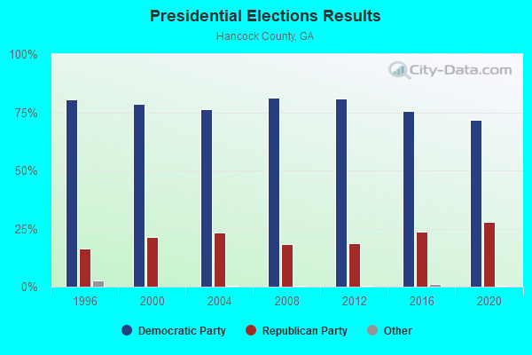
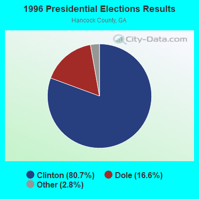
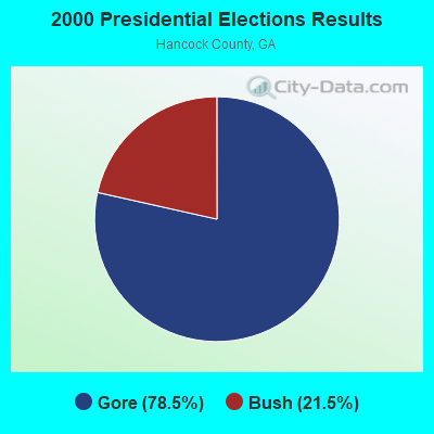
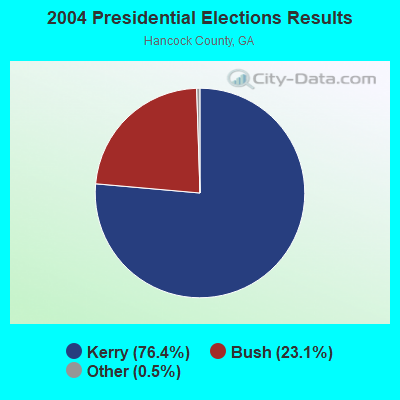

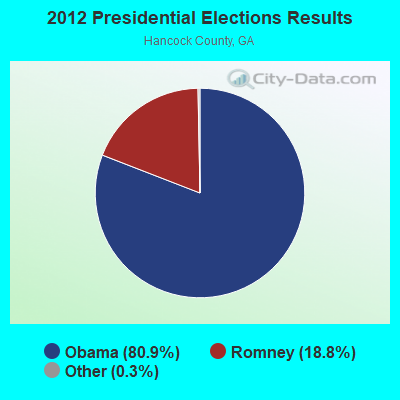
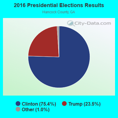

Graphs represent county-level data. Detailed 2008 Election Results
Religion statistics for Linton, GA (based on Hancock County data)
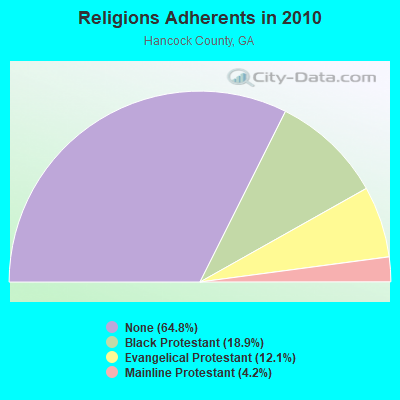
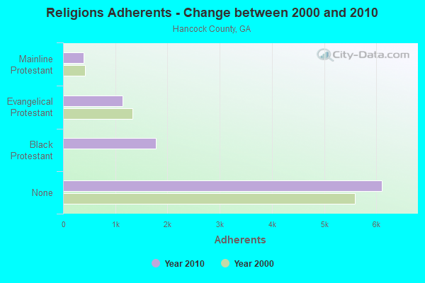
| Religion | Adherents | Congregations |
|---|---|---|
| Black Protestant | 1,779 | 12 |
| Evangelical Protestant | 1,139 | 13 |
| Mainline Protestant | 397 | 6 |
| Other | 6 | 1 |
| None | 6,108 | - |
Food Environment Statistics:
| This county: | 1.05 / 10,000 pop. |
| Georgia: | 1.91 / 10,000 pop. |
| Hancock County: | 1.05 / 10,000 pop. |
| Georgia: | 0.86 / 10,000 pop. |
| This county: | 7.32 / 10,000 pop. |
| Georgia: | 5.12 / 10,000 pop. |
| This county: | 13.9% |
| Georgia: | 10.4% |
| This county: | 34.7% |
| Georgia: | 27.8% |
| Hancock County: | 13.1% |
| Georgia: | 14.6% |
Strongest AM radio stations in Linton:
- WMAC (940 AM; 50 kW; MACON, GA; Owner: CUMULUS LICENSING CORP.)
- WKGQ (1060 AM; daytime; 1 kW; MILLEDGEVILLE, GA; Owner: KEYSTONE ENTERPRISES, INC.)
- WXJO (1120 AM; daytime; 10 kW; GORDON, GA; Owner: ROBERTS COMMUNICATIONS, INC.)
- WSB (750 AM; 50 kW; ATLANTA, GA; Owner: CXR HOLDINGS, INC.)
- WGST (640 AM; 50 kW; ATLANTA, GA; Owner: CITICASTERS LICENSES, L.P.)
- WCNN (680 AM; 50 kW; NORTH ATLANTA, GA; Owner: DICKEY BROADCASTING COMPANY)
- WGUN (1010 AM; 50 kW; ATLANTA, GA; Owner: WGUN, INC.)
- WLFJ (660 AM; daytime; 50 kW; GREENVILLE, SC; Owner: CLEAR CHANNEL BROADCASTING LICENSES, INC.)
- WNNG (1350 AM; 15 kW; WARNER ROBINS, GA; Owner: CHASE BROADCASTING, INC.)
- WQXI (790 AM; 28 kW; ATLANTA, GA; Owner: JEFFERSON-PILOT COMMUNICATIONS COMPANY OF GEORGIA)
- WAOK (1380 AM; 50 kW; ATLANTA, GA; Owner: INFINITY BROADCASTING OPERATIONS, INC.)
- WMLB (1160 AM; 50 kW; EAST POINT, GA; Owner: ATLANTA AREA BROADCASTING, INC.)
- WMVG (1450 AM; 1 kW; MILLEDGEVILLE, GA; Owner: WMVG, INC.)
Strongest FM radio stations in Linton:
- WLRR (100.7 FM; MILLEDGEVILLE, GA; Owner: PRESTON W. SMALL)
- W201BN (88.1 FM; MILLEDGEVILLE, GA; Owner: CALVARY CHAPEL OF TWIN FALLS, INC.)
- WMGZ (97.7 FM; EATONTON, GA; Owner: MIDDLE GEORGIA COMMUNICATIONS, INC.)
- WKZR (102.3 FM; MILLEDGEVILLE, GA; Owner: WMVG, INC.)
- WAKB (96.9 FM; WRENS, GA; Owner: RADIO ONE OF AUGUSTA, LLC)
- WJFL (101.9 FM; TENNILLE, GA; Owner: FALL LINE MEDIA, INC.)
- WQZY (95.9 FM; DUBLIN, GA; Owner: STATE BROADCASTING CORPORATION)
- WFXM (107.1 FM; GORDON, GA; Owner: ROBERTS COMMUNICATIONS, INC.)
- WGUR (88.9 FM; MILLEDGEVILLE, GA; Owner: GEORGIA COLLEGE & STATE UNIVERSITY)
- WVKX (103.7 FM; IRWINTON, GA; Owner: WILKINSON BROADCASTING, INC.)
- WPMA (102.7 FM; BUCKHEAD, GA; Owner: BARINOWSKI INVESTMENT COMPANY, L.P.)
- WPEZ (93.7 FM; JEFFERSONVILLE, GA; Owner: CUMULUS LICENSING CORP.)
- WSNT-FM (99.9 FM; SANDERSVILLE, GA; Owner: RADIO STATION WSNT, INC.)
- WJDS (88.7 FM; SPARTA, GA; Owner: AUGUSTA RADIO FELLOWSHIP INSTITUTE INC)
TV broadcast stations around Linton:
- WCES-TV (Channel 20; WRENS, GA; Owner: GEORGIA PUBLIC TELECOMMUNICATIONS COMMISSION)
- WDCO-TV (Channel 29; COCHRAN, GA; Owner: GEORGIA PUBLIC TELECOMMUNICATIONS COMMISSION)
- WPGA-TV (Channel 58; PERRY, GA; Owner: RADIO PERRY, INC.)
- WMGT-TV (Channel 41; MACON, GA; Owner: MORRIS NETWORK, INC.)
- WMAZ-TV (Channel 13; MACON, GA; Owner: GANNETT GEORGIA, L.P.)
- WGXA (Channel 24; MACON, GA; Owner: PIEDMONT TELEVISION OF MACON LICENSE LLC)

- 59.8%Bottled, tank, or LP gas
- 14.5%Electricity
- 12.4%Utility gas
- 7.9%Wood
- 5.4%Fuel oil, kerosene, etc.

- 57.1%Bottled, tank, or LP gas
- 42.9%Electricity
Linton compared to Georgia state average:
- Median household income below state average.
- Median house value significantly below state average.
- Unemployed percentage below state average.
- Black race population percentage above state average.
- Hispanic race population percentage significantly below state average.
- Median age below state average.
- Foreign-born population percentage significantly below state average.
- Renting percentage significantly below state average.
- Length of stay since moving in significantly above state average.
- Number of rooms per house significantly below state average.
- House age significantly below state average.
- Number of college students below state average.
- Percentage of population with a bachelor's degree or higher significantly below state average.