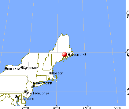
Holden, Maine
Submit your own pictures of this town and show them to the world
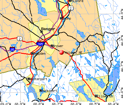
- OSM Map
- General Map
- Google Map
- MSN Map
Population change since 2000: +8.8%
 |
| Males: 1,515 | |
| Females: 1,561 |
| Median resident age: | 46.4 years |
| Maine median age: | 43.0 years |
Zip codes: 04429.
| Holden: | $91,671 |
| ME: | $69,543 |
Estimated per capita income in 2022: $50,351 (it was $25,047 in 2000)
Holden town income, earnings, and wages data
Estimated median house or condo value in 2022: $258,385 (it was $99,300 in 2000)
| Holden: | $258,385 |
| ME: | $290,600 |
Mean prices in 2022: all housing units: $235,563; detached houses: $252,705; townhouses or other attached units: $267,749; in 2-unit structures: $255,332; in 3-to-4-unit structures: $815,300; in 5-or-more-unit structures: $185,873; mobile homes: $93,017; occupied boats, rvs, vans, etc.: $21,333
Detailed information about poverty and poor residents in Holden, ME


- 2,95596.1%White alone
- 451.5%Hispanic
- 321.0%Two or more races
- 200.7%American Indian alone
- 150.5%Black alone
- 60.2%Native Hawaiian and Other
Pacific Islander alone - 30.10%Asian alone

Races in Holden detailed stats: ancestries, foreign born residents, place of birth
According to our research of Maine and other state lists, there were 9 registered sex offenders living in Holden, Maine as of May 26, 2024.
The ratio of all residents to sex offenders in Holden is 342 to 1.
Type |
2009 |
2010 |
2011 |
2012 |
2013 |
2014 |
2015 |
2016 |
2017 |
2018 |
2019 |
2020 |
2021 |
2022 |
|---|---|---|---|---|---|---|---|---|---|---|---|---|---|---|
| Murders (per 100,000) | 0 (0.0) | 0 (0.0) | 0 (0.0) | 0 (0.0) | 0 (0.0) | 0 (0.0) | 0 (0.0) | 0 (0.0) | 0 (0.0) | 0 (0.0) | 0 (0.0) | 0 (0.0) | 0 (0.0) | 0 (0.0) |
| Rapes (per 100,000) | 0 (0.0) | 0 (0.0) | 0 (0.0) | 0 (0.0) | 0 (0.0) | 0 (0.0) | 0 (0.0) | 0 (0.0) | 0 (0.0) | 0 (0.0) | 0 (0.0) | 2 (64.4) | 0 (0.0) | 0 (0.0) |
| Robberies (per 100,000) | 0 (0.0) | 1 (32.5) | 0 (0.0) | 1 (32.5) | 0 (0.0) | 0 (0.0) | 0 (0.0) | 2 (65.0) | 0 (0.0) | 0 (0.0) | 0 (0.0) | 0 (0.0) | 0 (0.0) | 0 (0.0) |
| Assaults (per 100,000) | 1 (33.3) | 0 (0.0) | 0 (0.0) | 1 (32.5) | 1 (32.3) | 1 (32.5) | 0 (0.0) | 1 (32.5) | 2 (65.6) | 2 (65.3) | 3 (97.4) | 0 (0.0) | 0 (0.0) | 0 (0.0) |
| Burglaries (per 100,000) | 20 (665.3) | 15 (487.6) | 15 (487.6) | 19 (617.7) | 32 (1,034) | 8 (259.9) | 12 (387.8) | 13 (422.5) | 8 (262.4) | 7 (228.7) | 3 (97.4) | 7 (225.4) | 2 (64.0) | 2 (60.4) |
| Thefts (per 100,000) | 34 (1,131) | 35 (1,138) | 34 (1,105) | 63 (2,048) | 50 (1,616) | 32 (1,040) | 25 (808.0) | 18 (585.0) | 14 (459.2) | 19 (620.7) | 15 (486.9) | 25 (804.9) | 21 (672.2) | 20 (603.9) |
| Auto thefts (per 100,000) | 1 (33.3) | 0 (0.0) | 0 (0.0) | 0 (0.0) | 0 (0.0) | 4 (130.0) | 2 (64.6) | 1 (32.5) | 0 (0.0) | 0 (0.0) | 3 (97.4) | 2 (64.4) | 1 (32.0) | 2 (60.4) |
| Arson (per 100,000) | 1 (33.3) | 0 (0.0) | 0 (0.0) | 0 (0.0) | 0 (0.0) | 0 (0.0) | 0 (0.0) | 0 (0.0) | 0 (0.0) | 0 (0.0) | 0 (0.0) | 0 (0.0) | 0 (0.0) | 0 (0.0) |
| City-Data.com crime index | 101.1 | 89.4 | 78.3 | 141.4 | 143.5 | 76.7 | 64.6 | 81.6 | 49.9 | 53.9 | 53.6 | 104.6 | 33.9 | 33.2 |
The City-Data.com crime index weighs serious crimes and violent crimes more heavily. Higher means more crime, U.S. average is 246.1. It adjusts for the number of visitors and daily workers commuting into cities.
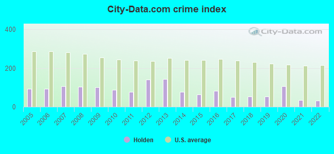
Crime rate in Holden detailed stats: murders, rapes, robberies, assaults, burglaries, thefts, arson
Full-time law enforcement employees in 2021, including police officers: 6 (6 officers - 6 male; 0 female).
| Officers per 1,000 residents here: | 1.92 |
| Maine average: | 1.71 |
 Recent articles from our blog. Our writers, many of them Ph.D. graduates or candidates, create easy-to-read articles on a wide variety of topics.

 | Looking to move outside Bangor with kids (6 replies) |
| Where to live? (21 replies) |
| Orrington v Veazie (maybe Brewer) Elementary schools and more! (0 replies) |
| Best place to live within 50 miles of Ellsworth (11 replies) |
| Moving to Bar Harbor 2016 (22 replies) |
| Bangor - good place to live, or not? (94 replies) |
Latest news from Holden, ME collected exclusively by city-data.com from local newspapers, TV, and radio stations
Ancestries: English (21.1%), Irish (18.0%), French (13.8%), Scottish (7.7%), French Canadian (6.5%), United States (6.4%).
Current Local Time: EST time zone
Incorporated on 04/13/1852
Elevation: 200 feet
Land area: 30.9 square miles.
Population density: 100 people per square mile (very low).
48 residents are foreign born
| This town: | 1.7% |
| Maine: | 2.9% |
| Holden town: | 1.5% ($1,441) |
| Maine: | 1.5% ($1,417) |
Nearest city with pop. 50,000+: Portland, ME  (109.6 miles , pop. 64,249).
Nearest city with pop. 200,000+: Boston, MA (207.7 miles , pop. 589,141).
Nearest city with pop. 1,000,000+: Bronx, NY (377.9 miles , pop. 1,332,650).
Nearest cities:
), ), ), ), )Latitude: 44.76 N, Longitude: 68.67 W
Area code commonly used in this area: 207


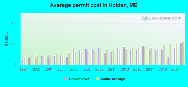
Single-family new house construction building permits:
- 2022: 12 buildings, average cost: $268,800
- 2021: 24 buildings, average cost: $210,000
- 2020: 3 buildings, average cost: $100,700
- 2019: 13 buildings, average cost: $178,800
- 2018: 13 buildings, average cost: $178,800
- 2017: 9 buildings, average cost: $177,800
- 2016: 6 buildings, average cost: $229,600
- 2015: 8 buildings, average cost: $177,900
- 2014: 8 buildings, average cost: $183,000
- 2013: 11 buildings, average cost: $220,900
- 2012: 8 buildings, average cost: $220,100
- 2011: 8 buildings, average cost: $152,500
- 2010: 12 buildings, average cost: $148,100
- 2009: 10 buildings, average cost: $209,900
- 2008: 13 buildings, average cost: $195,900
- 2007: 15 buildings, average cost: $188,800
- 2006: 22 buildings, average cost: $181,500
- 2005: 22 buildings, average cost: $188,100
- 2004: 17 buildings, average cost: $101,200
- 2003: 22 buildings, average cost: $119,300
- 2002: 12 buildings, average cost: $112,400
- 2001: 12 buildings, average cost: $95,000
- 2000: 25 buildings, average cost: $107,200
- 1999: 20 buildings, average cost: $85,400
- 1998: 19 buildings, average cost: $79,900
- 1997: 18 buildings, average cost: $76,100

| Here: | 3.1% |
| Maine: | 3.4% |


- Health care (19.8%)
- Construction (8.6%)
- Educational services (7.7%)
- Professional, scientific, technical services (5.2%)
- Public administration (3.9%)
- Paper (3.7%)
- Social assistance (3.4%)

- Construction (14.9%)
- Health care (10.5%)
- Paper (6.9%)
- Public administration (4.5%)
- Food & beverage stores (4.3%)
- Educational services (4.0%)
- Professional, scientific, technical services (3.5%)

- Health care (30.4%)
- Educational services (11.8%)
- Professional, scientific, technical services (7.1%)
- Social assistance (6.0%)
- Accommodation & food services (4.9%)
- Finance & insurance (4.1%)
- Public administration (3.1%)

- Other management occupations, except farmers and farm managers (5.3%)
- Material recording, scheduling, dispatching, and distributing workers (4.4%)
- Other office and administrative support workers, including supervisors (4.3%)
- Other sales and related occupations, including supervisors (3.8%)
- Preschool, kindergarten, elementary, and middle school teachers (3.7%)
- Building and grounds cleaning and maintenance occupations (3.2%)
- Secretaries and administrative assistants (3.2%)

- Other management occupations, except farmers and farm managers (6.6%)
- Electrical equipment mechanics and other installation, maintenance, and repair workers, including supervisors (5.8%)
- Material recording, scheduling, dispatching, and distributing workers (5.5%)
- Building and grounds cleaning and maintenance occupations (4.8%)
- Other production occupations, including supervisors (4.5%)
- Sales representatives, services, wholesale and manufacturing (4.4%)
- Other sales and related occupations, including supervisors (4.2%)

- Other office and administrative support workers, including supervisors (7.1%)
- Secretaries and administrative assistants (6.9%)
- Registered nurses (6.6%)
- Preschool, kindergarten, elementary, and middle school teachers (6.3%)
- Information and record clerks, except customer service representatives (5.3%)
- Other management occupations, except farmers and farm managers (3.8%)
- Financial clerks, except bookkeeping, accounting and auditing clerks (3.4%)
Average climate in Holden, Maine
Based on data reported by over 4,000 weather stations


(lower is better)

Air Quality Index (AQI) level in 2023 was 61.1. This is about average.
| City: | 61.1 |
| U.S.: | 72.6 |

Ozone [ppb] level in 2023 was 33.6. This is about average. Closest monitor was 1.7 miles away from the city center.
| City: | 33.6 |
| U.S.: | 33.3 |

Particulate Matter (PM2.5) [µg/m3] level in 2023 was 5.62. This is significantly better than average. Closest monitor was 5.4 miles away from the city center.
| City: | 5.62 |
| U.S.: | 8.11 |
Earthquake activity:
Holden-area historical earthquake activity is significantly above Maine state average. It is 81% smaller than the overall U.S. average.On 10/16/2012 at 23:12:25, a magnitude 4.7 (4.7 ML, Depth: 10.0 mi, Class: Light, Intensity: IV - V) earthquake occurred 127.1 miles away from Holden center
On 4/20/2002 at 10:50:47, a magnitude 5.3 (5.3 ML, Depth: 3.0 mi, Class: Moderate, Intensity: VI - VII) earthquake occurred 247.8 miles away from Holden center
On 4/20/2002 at 10:50:47, a magnitude 5.2 (5.2 MB, 4.2 MS, 5.2 MW, 5.0 MW) earthquake occurred 249.0 miles away from Holden center
On 1/19/1982 at 00:14:42, a magnitude 4.7 (4.5 MB, 4.7 MD, 4.5 LG) earthquake occurred 169.5 miles away from Holden center
On 10/7/1983 at 10:18:46, a magnitude 5.3 (5.1 MB, 5.3 LG, 5.1 ML) earthquake occurred 285.8 miles away from the city center
On 2/26/1999 at 03:38:43, a magnitude 3.8 (3.8 LG, Depth: 2.0 mi, Class: Light, Intensity: II - III) earthquake occurred 46.0 miles away from Holden center
Magnitude types: regional Lg-wave magnitude (LG), body-wave magnitude (MB), duration magnitude (MD), local magnitude (ML), surface-wave magnitude (MS), moment magnitude (MW)
Natural disasters:
The number of natural disasters in Penobscot County (19) is greater than the US average (15).Major Disasters (Presidential) Declared: 11
Emergencies Declared: 7
Causes of natural disasters: Floods: 9, Storms: 8, Snows: 5, Heavy Rains: 2, Blizzard: 1, Hurricane: 1, Ice Storm: 1, Snowfall: 1, Wind: 1, Winter Storm: 1, Other: 2 (Note: some incidents may be assigned to more than one category).

Hospitals and medical centers near Holden:
- KINDRED TRANSITIONAL CARE AND REHAB-BREWER (Nursing Home, about 5 miles away; BREWER, ME)
- NEW HOPE HOSPICE INC (Hospital, about 5 miles away; EDDINGTON, ME)
- MAINE VETERANS HOME - BANGOR (Nursing Home, about 5 miles away; BANGOR, ME)
- EASTERN MAINE MEDICAL CENTER Acute Care Hospitals (about 6 miles away; BANGOR, ME)
- HOSPICE OF EASTERN MAINE HHA (Home Health Center, about 6 miles away; BANGOR, ME)
- ELIZABETH LEVINSON CENTER (Hospital, about 6 miles away; BANGOR, ME)
- GENTIVA HEALTH SERVICES (Home Health Center, about 6 miles away; BANGOR, ME)
Colleges/universities with over 2000 students nearest to Holden:
- Husson University (about 8 miles; Bangor, ME; Full-time enrollment: 2,421)
- University of Maine (about 10 miles; Orono, ME; FT enrollment: 8,931)
- University of Maine at Augusta (about 63 miles; Augusta, ME; FT enrollment: 3,204)
- University of Maine at Farmington (about 73 miles; Farmington, ME; FT enrollment: 2,036)
- Southern Maine Community College (about 109 miles; South Portland, ME; FT enrollment: 4,666)
- University of Southern Maine (about 110 miles; Portland, ME; FT enrollment: 6,647)
- Saint Joseph's College of Maine (about 111 miles; Standish, ME; FT enrollment: 2,010)
Public elementary/middle schools in Holden:
- HOLBROOK SCHOOL (Location: 202 KIDDER HILL ROAD, Grades: 5-8)
- HOLDEN SCHOOL (Location: 590 MAIN ROAD, Grades: KG-4)
Points of interest:
Notable locations in Holden: Clewleyville Corners (A), Holden Station (B), Woodland Terrace Golf Course (C), Harts Corners (D), Holden Fire Rescue Department (E). Display/hide their locations on the map
Churches in Holden include: Holden Congregational Church (A), East Holden Community Church (B). Display/hide their locations on the map
Cemeteries: Copeland Hill Cemetery (1), Clewleyville Cemetery (2). Display/hide their locations on the map
Lake: George Pond (A). Display/hide its location on the map
Tourist attraction: Felt Brook Go Karts (Arcades & Amusements; 9 Main Rd) (1). Display/hide its approximate location on the map
Drinking water stations with addresses in Holden and their reported violations in the past:
CEDAR HAVEN MOBILE HOME PK (Address: CEDAR HAVEN MOBILE HOME PARK , Population served: 390, Groundwater):Past health violations:RED BARN CAMPGROUND (Population served: 300, Groundwater):
- MCL, Monthly (TCR) - In OCT-2005, Contaminant: Coliform. Follow-up actions: St Public Notif requested (OCT-21-2005), St Violation/Reminder Notice (OCT-21-2005), St Public Notif received (2 times from DEC-08-2005 to DEC-08-2005), St Compliance achieved (JUL-10-2008)
Past monitoring violations:MSAD 63 HOLBROOK SCHOOL (Population served: 284, Groundwater):
- One routine major monitoring violation
Past monitoring violations:MSAD 63 HOLDEN SCHOOL (Population served: 213, Groundwater):
- One routine major monitoring violation
Past monitoring violations:TRADITIONS GOLF CLUB (Population served: 180, Groundwater):
- Follow-up Or Routine LCR Tap M/R - In JAN-01-2012, Contaminant: Lead and Copper Rule. Follow-up actions: St Public Notif requested (FEB-16-2012), St Formal NOV issued (FEB-16-2012), St Compliance achieved (JUN-26-2012), St Public Notif received (MAR-28-2013)
- One routine major monitoring violation
Past health violations:G&M MARKET (Population served: 100, Groundwater):Past monitoring violations:
- MCL, Monthly (TCR) - In MAY-2008, Contaminant: Coliform. Follow-up actions: St Public Notif requested (MAY-30-2008), St Formal NOV issued (MAY-30-2008), St Compliance achieved (JUL-01-2008), St Public Notif received (OCT-23-2013), St Site Visit (enforcement) (OCT-23-2013)
- MCL, Monthly (TCR) - In DEC-2007, Contaminant: Coliform. Follow-up actions: St Public Notif requested (DEC-13-2007), St Boil Water Order (DEC-13-2007), St Formal NOV issued (DEC-13-2007), St Tech Assistance Visit (DEC-13-2007), St Public Notif received (DEC-31-2007), St Intentional no-action (SEP-09-2011), St Compliance achieved (SEP-09-2011)
- MCL, Monthly (TCR) - In MAY-2007, Contaminant: Coliform. Follow-up actions: St Public Notif requested (MAY-14-2007), St Violation/Reminder Notice (MAY-14-2007), St Public Notif received (2 times from JUN-01-2007 to JUN-01-2007), St Compliance achieved (SEP-07-2011), St Intentional no-action (SEP-09-2011)
- 7 routine major monitoring violations
- One regular monitoring violation
Past health violations:RED BARN DINER (Population served: 90, Groundwater):Past monitoring violations:
- MCL, Monthly (TCR) - In SEP-2013, Contaminant: Coliform. Follow-up actions: St Formal NOV issued (SEP-20-2013), St Public Notif requested (SEP-20-2013), St Public Notif received (OCT-08-2013), St Compliance achieved (OCT-21-2013)
- MCL, Monthly (TCR) - In JUL-2013, Contaminant: Coliform. Follow-up actions: St Public Notif requested (AUG-16-2013), St Formal NOV issued (AUG-16-2013), St Compliance achieved (OCT-21-2013), St Public Notif received (NOV-07-2013)
- One regular monitoring violation
Past monitoring violations:CSD 8 AIRLINE COMM SCHOOL (Population served: 52, Groundwater):
- 2 routine major monitoring violations
- 2 regular monitoring violations
Past monitoring violations:
- One routine major monitoring violation
Drinking water stations with addresses in Holden that have no violations reported:
- PINE CONE MOBILE HOME CT #1 (Population served: 210, Primary Water Source Type: Groundwater)
| This town: | 2.4 people |
| Maine: | 2.3 people |
| This town: | 70.9% |
| Whole state: | 62.9% |
| This town: | 5.9% |
| Whole state: | 9.4% |
Likely homosexual households (counted as self-reported same-sex unmarried-partner households)
- Lesbian couples: 0.2% of all households
- Gay men: 0.2% of all households
| This town: | 6.5% |
| Whole state: | 10.9% |
| This town: | 1.8% |
| Whole state: | 4.1% |
For population 15 years and over in Holden:
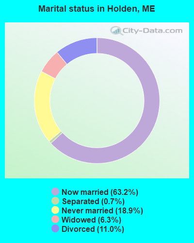
- Never married: 18.9%
- Now married: 63.2%
- Separated: 0.7%
- Widowed: 6.3%
- Divorced: 11.0%
For population 25 years and over in Holden:
- High school or higher: 93.0%
- Bachelor's degree or higher: 28.2%
- Graduate or professional degree: 8.9%
- Unemployed: 3.1%
- Mean travel time to work (commute): 21.5 minutes


| Here: | 9.8 |
| Maine average: | 11.2 |


Graphs represent county-level data. Detailed 2008 Election Results
Religion statistics for Holden, ME (based on Penobscot County data)


| Religion | Adherents | Congregations |
|---|---|---|
| Catholic | 16,581 | 15 |
| Mainline Protestant | 9,715 | 59 |
| Evangelical Protestant | 7,523 | 80 |
| Other | 2,936 | 22 |
| Orthodox | 300 | 1 |
| None | 116,868 | - |
Food Environment Statistics:
| This county: | 2.29 / 10,000 pop. |
| Maine: | 2.80 / 10,000 pop. |
| Penobscot County: | 0.13 / 10,000 pop. |
| Maine: | 0.14 / 10,000 pop. |
| Penobscot County: | 2.56 / 10,000 pop. |
| State: | 2.20 / 10,000 pop. |
| This county: | 5.72 / 10,000 pop. |
| Maine: | 5.75 / 10,000 pop. |
| This county: | 7.41 / 10,000 pop. |
| Maine: | 11.02 / 10,000 pop. |
| Penobscot County: | 9.0% |
| State: | 8.2% |
| Penobscot County: | 28.0% |
| Maine: | 25.0% |
| Businesses in Holden, ME | ||||
| Name | Count | Name | Count | |
|---|---|---|---|---|
| Circle K | 1 | MasterBrand Cabinets | 3 | |
| Dunkin Donuts | 1 | Subway | 1 | |
Strongest AM radio stations in Holden:
- WABI (910 AM; 5 kW; BANGOR, ME; Owner: CLEAR CHANNEL BROADCASTING LICENSES, INC.)
- WZON (620 AM; 5 kW; BANGOR, ME; Owner: THE ZONE CORPORATION)
- WNZS (1340 AM; 1 kW; VEAZIE, ME; Owner: WATERFRONT COMMUNICATIONS INC.)
- WDEA (1370 AM; 5 kW; ELLSWORTH, ME; Owner: CUMULUS LICENSING CORP.)
- WSKW (1160 AM; 10 kW; SKOWHEGAN, ME; Owner: MOUNTAIN WIRELESS, INCORPORATED)
- WRKO (680 AM; 50 kW; BOSTON, MA; Owner: ENTERCOM BOSTON LICENSE, LLC)
- WTME (780 AM; 10 kW; RUMFORD, ME; Owner: MOUNTAIN VALLEY BROADCASTING, INC.)
- WEEI (850 AM; 50 kW; BOSTON, MA; Owner: ENTERCOM BOSTON LICENSE, LLC)
- WBZ (1030 AM; 50 kW; BOSTON, MA; Owner: INFINITY BROADCASTING OPERATIONS, INC.)
- WCRN (830 AM; 50 kW; WORCESTER, MA; Owner: CARTER BROADCASTING CORPORATION)
- WNNZ (640 AM; 50 kW; WESTFIELD, MA; Owner: CLEAR CHANNEL BROADCASTING LICENSES, INC.)
- WFAU (1280 AM; 5 kW; GARDINER, ME; Owner: CAPSTAR TX LIMITED PARTNERSHIP)
- WKOX (1200 AM; 50 kW; FRAMINGHAM, MA; Owner: CAPSTAR TX LIMITED PARTNERSHIP)
Strongest FM radio stations in Holden:
- WMEH (90.9 FM; BANGOR, ME; Owner: MAINE PUBLIC BROADCASTING CORPORATION)
- WEZQ (92.9 FM; BANGOR, ME; Owner: CUMULUS LICENSING CORP.)
- WWMJ (95.7 FM; ELLSWORTH, ME; Owner: CUMULUS LICENSING CORP.)
- WKIT-FM (100.3 FM; BREWER, ME; Owner: THE ZONE CORPORATION)
- WBFB (104.7 FM; BELFAST, ME; Owner: CLEAR CHANNEL BROADCASTING LICENSES, INC.)
- WWBX (97.1 FM; BANGOR, ME; Owner: CLEAR CHANNEL BROADCASTING LICENSES, INC.)
- WHCF (88.5 FM; BANGOR, ME; Owner: BANGOR BAPTIST CHURCH)
- WVOM (103.9 FM; HOWLAND, ME; Owner: CLEAR CHANNEL BROADCASTING LICENSES, INC.)
- WERU-FM (89.9 FM; BLUE HILL, ME; Owner: SALT POND COMMUNITY B/C COMPANY)
- WFZX (101.7 FM; SEARSPORT, ME; Owner: CLEAR CHANNEL BROADCASTING LICENSES, INC.)
- WBZN (107.3 FM; OLD TOWN, ME; Owner: CUMULUS LICENSING CORP.)
- WQCB (106.5 FM; BREWER, ME; Owner: CUMULUS LICENSING CORP.)
- WNSX (97.7 FM; WINTER HARBOR, ME; Owner: CLEAR CHANNEL BROADCASTING LICENSES, INC.)
- WMEP (90.5 FM; CAMDEN, ME; Owner: MAINE PUBLIC BROADCASTING CORP.)
- WLKE (99.1 FM; BAR HARBOR, ME; Owner: CLEAR CHANNEL BROADCASTING LICENSES, INC.)
- WQSS (102.5 FM; CAMDEN, ME; Owner: CLEAR CHANNEL BROADCASTING LICENSES, INC.)
- WMEB-FM (91.9 FM; ORONO, ME; Owner: UNIVERSITY OF MAINE SYSTEM)
- W275AE (102.9 FM; BANGOR, ME; Owner: SALT POND COMMUNITY BROADCASTING, INC.)
- WGUY (102.1 FM; DEXTER, ME; Owner: CONCORD MEDIA GROUP, INC.)
- WBQI (107.7 FM; BAR HARBOR, ME; Owner: MARINER BROADCASTING, L.P.)
TV broadcast stations around Holden:
- WLBZ (Channel 2; BANGOR, ME; Owner: PACIFIC AND SOUTHERN COMPANY, INC.)
- WBGR-LP (Channel 33; BANGOR/DEDHAM, ME; Owner: MAINE FAMILY BROADCASTING, INC.)
- WMEB-TV (Channel 12; ORONO, ME; Owner: MAINE PUBLIC BROADCASTING CORPORATION)
- W66CL (Channel 66; BANGOR, ME; Owner: MS COMMUNICATIONS, LLC)
- WBAN-LP (Channel 9; BANGOR, ME; Owner: BANGOR MEDIA GROUP, LLC)
- WCKD-LP (Channel 30; BANGOR/DEDHAM, ME; Owner: J. MCLEOD, ME FAMILY B/CING., INC.)
- WVII-TV (Channel 7; BANGOR, ME; Owner: BANGOR COMMUNICATIONS, INC.)
- WFVX-LP (Channel 22; BANGOR, ME; Owner: ROCKFLEET BROADCASTING III, LLC)
- W39CC (Channel 39; BANGOR, ME; Owner: MS COMMUNICATIONS, LLC)
- W42BZ (Channel 42; BANGOR, ME; Owner: MS COMMUNICATIONS, LLC)
- W50BX (Channel 50; BANGOR, ME; Owner: MS COMMUNICATIONS, LLC)
- W54CG (Channel 54; BANGOR, ME; Owner: MS COMMUNICATIONS, LLC)
- WABI-TV (Channel 5; BANGOR, ME; Owner: COMMUNITY BROADCASTING SERVICE)
- W36CK (Channel 36; BANGOR, ME; Owner: TRINITY BROADCASTING NETWORK)

FCC Registered Antenna Towers:
11 (See the full list of FCC Registered Antenna Towers in Holden)FCC Registered Broadcast Land Mobile Towers:
2- 153 Main Rd (Lat: 44.761667 Lon: -68.698611), Type: Building, Structure height: 9.1 m, Call Sign: KNEQ236,
Assigned Frequencies: 155.265 MHz, Grant Date: 11/17/2022, Expiration Date: 02/11/2033, Registrant: Browns Communications, 162 Bangor Road, Ellsworth, ME 04605, Phone: (207) 667-2254, Fax: (207) 667-6335, Email:
- Levensellar Rd (Lat: 44.804444 Lon: -68.663611), Type: Pole, Structure height: 6 m, Call Sign: WPKW529,
Assigned Frequencies: 173.203 MHz, Grant Date: 07/12/2022, Expiration Date: 08/14/2032, Certifier: Stephen M Bost, Registrant: New Wave Licensing Services Inc., 517 Sachs Road, Gettysburg, PA 17325, Phone: (717) 334-0910, Fax: (717) 334-4739, Email:
FCC Registered Microwave Towers:
5 (See the full list of FCC Registered Microwave Towers in this town)FCC Registered Paging Towers:
4 (See the full list of FCC Registered Paging Towers)FCC Registered Amateur Radio Licenses:
17 (See the full list of FCC Registered Amateur Radio Licenses in Holden)FAA Registered Aircraft:
10 (See the full list of FAA Registered Aircraft in Holden)2003 - 2018 National Fire Incident Reporting System (NFIRS) incidents
- Fire incident types reported to NFIRS in Holden, ME
- 14956.0%Structure Fires
- 5420.3%Outside Fires
- 3312.4%Other
- 3011.3%Mobile Property/Vehicle Fires
 According to the data from the years 2003 - 2018 the average number of fire incidents per year is 17. The highest number of reported fires - 35 took place in 2010, and the least - 3 in 2003. The data has an increasing trend.
 When looking into fire subcategories, the most reports belonged to: Structure Fires (56.0%), and Outside Fires (20.3%).
- 90.6%Fuel oil, kerosene, etc.
- 6.3%Wood
- 1.8%Bottled, tank, or LP gas
- 1.3%Electricity
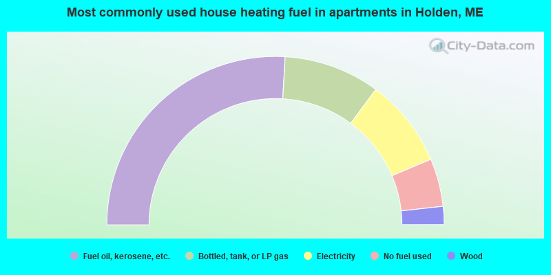
- 51.8%Fuel oil, kerosene, etc.
- 18.4%Bottled, tank, or LP gas
- 17.0%Electricity
- 9.2%No fuel used
- 3.5%Wood
Holden compared to Maine state average:
- Unemployed percentage significantly below state average.
- Black race population percentage significantly below state average.
- Foreign-born population percentage below state average.
- Renting percentage below state average.
- Length of stay since moving in significantly above state average.
- Number of rooms per house significantly below state average.
- House age significantly below state average.

|
Total of 3 patent applications in 2008-2024.