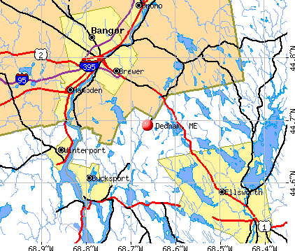
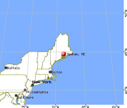
Dedham, Maine
Submit your own pictures of this town and show them to the world
- OSM Map
- General Map
- Google Map
- MSN Map
Population change since 2000: +18.2%
 |
| Males: 865 | |
| Females: 816 |
| Median resident age: | 46.2 years |
| Maine median age: | 43.0 years |
Zip codes: 04429.
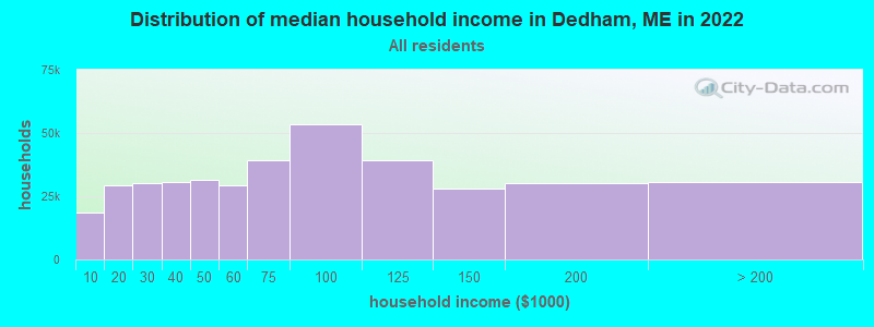
| Dedham: | $87,460 |
| ME: | $69,543 |
Estimated per capita income in 2022: $46,649 (it was $22,975 in 2000)
Dedham town income, earnings, and wages data
Estimated median house or condo value in 2022: $287,531 (it was $100,400 in 2000)
| Dedham: | $287,531 |
| ME: | $290,600 |
Mean prices in 2022: all housing units: $379,336; detached houses: $396,802; townhouses or other attached units: $600,716; in 2-unit structures: $274,479; in 3-to-4-unit structures: $212,346; in 5-or-more-unit structures: $146,369; mobile homes: $158,183; occupied boats, rvs, vans, etc.: $16,454
Detailed information about poverty and poor residents in Dedham, ME


- 1,63097.0%White alone
- 130.8%Hispanic
- 110.7%Two or more races
- 100.6%Asian alone
- 80.5%American Indian alone
- 60.4%Black alone
- 30.2%Other race alone

Races in Dedham detailed stats: ancestries, foreign born residents, place of birth
According to our research of Maine and other state lists, there were 3 registered sex offenders living in Dedham, Maine as of May 26, 2024.
The ratio of all residents to sex offenders in Dedham is 560 to 1.
The ratio of registered sex offenders to all residents in this city is near the state average.
 Recent articles from our blog. Our writers, many of them Ph.D. graduates or candidates, create easy-to-read articles on a wide variety of topics.

 | Orrington v Veazie (maybe Brewer) Elementary schools and more! (0 replies) |
| Best place to live within 50 miles of Ellsworth (11 replies) |
| artist moving to Brewer/Bangor area. (16 replies) |
| Great Bangor suburb to live for families (19 replies) |
| Where Are The Attractive Young Women in Bangor? (12 replies) |
| Need help planning a scouting trip to northern maine (3 replies) |
Latest news from Dedham, ME collected exclusively by city-data.com from local newspapers, TV, and radio stations
Ancestries: English (23.3%), Irish (16.4%), French (10.4%), United States (8.2%), German (7.2%), Italian (4.9%).
Current Local Time: EST time zone
Incorporated on 02/07/1827
Elevation: 136 feet
Land area: 39.2 square miles.
Population density: 43 people per square mile (very low).
18 residents are foreign born
| This town: | 1.3% |
| Maine: | 2.9% |
| Dedham town: | 1.2% ($1,192) |
| Maine: | 1.5% ($1,417) |
Nearest city with pop. 50,000+: Portland, ME  (109.4 miles , pop. 64,249).
Nearest city with pop. 200,000+: Boston, MA (206.2 miles , pop. 589,141).
Nearest city with pop. 1,000,000+: Bronx, NY (377.5 miles , pop. 1,332,650).
Nearest cities:
), ), )Latitude: 44.69 N, Longitude: 68.59 W
Area code commonly used in this area: 207

Single-family new house construction building permits:
- 2022: 2 buildings, average cost: $279,200
- 2021: 5 buildings, average cost: $259,200
- 2020: 5 buildings, average cost: $248,200
- 2019: 2 buildings, average cost: $282,200
- 2017: 1 building, cost: $267,800
- 2016: 4 buildings, average cost: $261,800
- 2015: 2 buildings, average cost: $257,200
- 2014: 4 buildings, average cost: $211,200
- 2013: 3 buildings, average cost: $207,700
- 2012: 2 buildings, average cost: $210,300
- 2011: 7 buildings, average cost: $193,200
- 2010: 5 buildings, average cost: $214,600
- 2009: 1 building, cost: $225,300
- 2008: 1 building, cost: $220,200
- 2007: 3 buildings, average cost: $199,400
- 2006: 8 buildings, average cost: $190,500
- 2005: 15 buildings, average cost: $172,000
- 2004: 26 buildings, average cost: $137,000
- 2003: 18 buildings, average cost: $132,800
- 2002: 24 buildings, average cost: $130,700
- 2001: 13 buildings, average cost: $121,400
- 2000: 9 buildings, average cost: $95,700
- 1999: 9 buildings, average cost: $95,700
- 1998: 9 buildings, average cost: $95,700
- 1997: 16 buildings, average cost: $91,700


| Here: | 3.0% |
| Maine: | 3.4% |


- Health care (14.3%)
- Educational services (13.5%)
- Construction (8.1%)
- Public administration (4.0%)
- Accommodation & food services (3.8%)
- Professional, scientific, technical services (3.5%)
- Motor vehicle & parts dealers (3.3%)

- Construction (14.7%)
- Educational services (7.1%)
- Health care (5.9%)
- Professional, scientific, technical services (5.7%)
- Public administration (4.8%)
- Paper (4.8%)
- Motor vehicle & parts dealers (4.3%)

- Health care (23.8%)
- Educational services (20.6%)
- Accommodation & food services (5.3%)
- Finance & insurance (4.3%)
- Social assistance (4.0%)
- Public administration (3.2%)
- Personal & laundry services (2.7%)

- Other management occupations, except farmers and farm managers (7.0%)
- Other office and administrative support workers, including supervisors (5.8%)
- Other sales and related occupations, including supervisors (5.0%)
- Preschool, kindergarten, elementary, and middle school teachers (4.4%)
- Retail sales workers, except cashiers (4.0%)
- Driver/sales workers and truck drivers (3.9%)
- Secretaries and administrative assistants (3.6%)

- Other management occupations, except farmers and farm managers (9.3%)
- Driver/sales workers and truck drivers (6.2%)
- Other sales and related occupations, including supervisors (5.7%)
- Electrical equipment mechanics and other installation, maintenance, and repair workers, including supervisors (5.5%)
- Retail sales workers, except cashiers (4.5%)
- Building and grounds cleaning and maintenance occupations (3.6%)
- Material recording, scheduling, dispatching, and distributing workers (3.1%)

- Other office and administrative support workers, including supervisors (9.9%)
- Preschool, kindergarten, elementary, and middle school teachers (8.0%)
- Secretaries and administrative assistants (6.7%)
- Other management occupations, except farmers and farm managers (4.5%)
- Registered nurses (4.3%)
- Material recording, scheduling, dispatching, and distributing workers (4.3%)
- Other sales and related occupations, including supervisors (4.3%)
Average climate in Dedham, Maine
Based on data reported by over 4,000 weather stations


(lower is better)

Air Quality Index (AQI) level in 2023 was 61.1. This is about average.
| City: | 61.1 |
| U.S.: | 72.6 |

Ozone [ppb] level in 2023 was 33.6. This is about average. Closest monitor was 2.9 miles away from the city center.
| City: | 33.6 |
| U.S.: | 33.3 |

Particulate Matter (PM2.5) [µg/m3] level in 2023 was 5.62. This is significantly better than average. Closest monitor was 11.8 miles away from the city center.
| City: | 5.62 |
| U.S.: | 8.11 |
Earthquake activity:
Dedham-area historical earthquake activity is significantly above Maine state average. It is 80% smaller than the overall U.S. average.On 10/16/2012 at 23:12:25, a magnitude 4.7 (4.7 ML, Depth: 10.0 mi, Class: Light, Intensity: IV - V) earthquake occurred 127.4 miles away from Dedham center
On 4/20/2002 at 10:50:47, a magnitude 5.3 (5.3 ML, Depth: 3.0 mi, Class: Moderate, Intensity: VI - VII) earthquake occurred 251.9 miles away from Dedham center
On 4/20/2002 at 10:50:47, a magnitude 5.2 (5.2 MB, 4.2 MS, 5.2 MW, 5.0 MW) earthquake occurred 253.1 miles away from Dedham center
On 1/19/1982 at 00:14:42, a magnitude 4.7 (4.5 MB, 4.7 MD, 4.5 LG) earthquake occurred 170.7 miles away from the city center
On 10/7/1983 at 10:18:46, a magnitude 5.3 (5.1 MB, 5.3 LG, 5.1 ML) earthquake occurred 289.2 miles away from the city center
On 2/26/1999 at 03:38:43, a magnitude 3.8 (3.8 LG, Depth: 2.0 mi, Class: Light, Intensity: II - III) earthquake occurred 48.2 miles away from the city center
Magnitude types: regional Lg-wave magnitude (LG), body-wave magnitude (MB), duration magnitude (MD), local magnitude (ML), surface-wave magnitude (MS), moment magnitude (MW)
Natural disasters:
The number of natural disasters in Hancock County (18) is near the US average (15).Major Disasters (Presidential) Declared: 11
Emergencies Declared: 6
Causes of natural disasters: Floods: 9, Storms: 8, Snows: 5, Blizzard: 1, Heavy Rain: 1, Hurricane: 1, Ice Storm: 1, Landslide: 1, Snowfall: 1, Wind: 1, Winter Storm: 1, Other: 2 (Note: some incidents may be assigned to more than one category).

Hospitals and medical centers near Dedham:
- NEW HOPE HOSPICE INC (Hospital, about 8 miles away; EDDINGTON, ME)
- KINDRED TRANSITIONAL CARE AND REHAB-BREWER (Nursing Home, about 11 miles away; BREWER, ME)
- MAINE VETERANS HOME - BANGOR (Nursing Home, about 12 miles away; BANGOR, ME)
- EASTERN MAINE MEDICAL CENTER Acute Care Hospitals (about 12 miles away; BANGOR, ME)
- HOSPICE OF EASTERN MAINE HHA (Home Health Center, about 12 miles away; BANGOR, ME)
- ELIZABETH LEVINSON CENTER (Hospital, about 12 miles away; BANGOR, ME)
- AMEDISYS HOME HEALTH OF BANGOR (Home Health Center, about 12 miles away; BANGOR, ME)
Colleges/universities with over 2000 students nearest to Dedham:
- Husson University (about 15 miles; Bangor, ME; Full-time enrollment: 2,421)
- University of Maine (about 16 miles; Orono, ME; FT enrollment: 8,931)
- University of Maine at Augusta (about 65 miles; Augusta, ME; FT enrollment: 3,204)
- University of Maine at Farmington (about 77 miles; Farmington, ME; FT enrollment: 2,036)
- Southern Maine Community College (about 109 miles; South Portland, ME; FT enrollment: 4,666)
- University of Southern Maine (about 110 miles; Portland, ME; FT enrollment: 6,647)
- Saint Joseph's College of Maine (about 112 miles; Standish, ME; FT enrollment: 2,010)
Points of interest:
Notable locations in Dedham: Camp Matomba (A), Lucerne Hills Golf Club (B), Dedham - Lucerne Fire Department Dedham Station (C), Dedham - Lucerne Fire Department Lucerne Station (D). Display/hide their locations on the map
Church in Dedham: Our Lady of the Lake Chapel (A). Display/hide its location on the map
Cemeteries: Union Cemetery (1), Eastern Cemetery (2), Central Cemetery (3). Display/hide their locations on the map
Lakes, reservoirs, and swamps: Mountainy Pond (A), Burnt Pond (B), Goose Pond (C), Hanson Pond (D), Harriman Pond (E), Hatcase Pond (F), Hurd Pond (G), Little Hatcase Pond (H). Display/hide their locations on the map
Streams, rivers, and creeks: Mann Brook (A), Jellison Brook (B). Display/hide their locations on the map
Drinking water stations with addresses in Dedham that have no violations reported:
- LUCERNE INN (Population served: 705, Primary Water Source Type: Groundwater)
| This town: | 2.4 people |
| Maine: | 2.3 people |
| This town: | 69.9% |
| Whole state: | 62.9% |
| This town: | 10.0% |
| Whole state: | 9.4% |
Likely homosexual households (counted as self-reported same-sex unmarried-partner households)
- Lesbian couples: 0.9% of all households
- Gay men: 0.4% of all households
| This town: | 5.2% |
| Whole state: | 10.9% |
| This town: | 3.1% |
| Whole state: | 4.1% |
For population 15 years and over in Dedham:

- Never married: 25.3%
- Now married: 61.0%
- Separated: 0.8%
- Widowed: 4.4%
- Divorced: 8.5%
For population 25 years and over in Dedham:
- High school or higher: 92.0%
- Bachelor's degree or higher: 30.5%
- Graduate or professional degree: 11.0%
- Unemployed: 3.2%
- Mean travel time to work (commute): 27.0 minutes


| Here: | 10.1 |
| Maine average: | 11.2 |


Graphs represent county-level data. Detailed 2008 Election Results
Religion statistics for Dedham, ME (based on Hancock County data)


| Religion | Adherents | Congregations |
|---|---|---|
| Mainline Protestant | 4,691 | 58 |
| Catholic | 2,523 | 9 |
| Evangelical Protestant | 1,288 | 23 |
| Other | 820 | 11 |
| None | 45,096 | - |
Food Environment Statistics:
| Hancock County: | 6.01 / 10,000 pop. |
| Maine: | 2.80 / 10,000 pop. |
| Here: | 1.69 / 10,000 pop. |
| State: | 2.20 / 10,000 pop. |
| This county: | 4.89 / 10,000 pop. |
| Maine: | 5.75 / 10,000 pop. |
| Hancock County: | 21.61 / 10,000 pop. |
| Maine: | 11.02 / 10,000 pop. |
| Hancock County: | 7.4% |
| Maine: | 8.2% |
| Here: | 25.4% |
| Maine: | 25.0% |
Strongest AM radio stations in Dedham:
- WABI (910 AM; 5 kW; BANGOR, ME; Owner: CLEAR CHANNEL BROADCASTING LICENSES, INC.)
- WZON (620 AM; 5 kW; BANGOR, ME; Owner: THE ZONE CORPORATION)
- WDEA (1370 AM; 5 kW; ELLSWORTH, ME; Owner: CUMULUS LICENSING CORP.)
- WNZS (1340 AM; 1 kW; VEAZIE, ME; Owner: WATERFRONT COMMUNICATIONS INC.)
- WSKW (1160 AM; 10 kW; SKOWHEGAN, ME; Owner: MOUNTAIN WIRELESS, INCORPORATED)
- WRKO (680 AM; 50 kW; BOSTON, MA; Owner: ENTERCOM BOSTON LICENSE, LLC)
- WTME (780 AM; 10 kW; RUMFORD, ME; Owner: MOUNTAIN VALLEY BROADCASTING, INC.)
- WEEI (850 AM; 50 kW; BOSTON, MA; Owner: ENTERCOM BOSTON LICENSE, LLC)
- WBZ (1030 AM; 50 kW; BOSTON, MA; Owner: INFINITY BROADCASTING OPERATIONS, INC.)
- WCRN (830 AM; 50 kW; WORCESTER, MA; Owner: CARTER BROADCASTING CORPORATION)
- WNNZ (640 AM; 50 kW; WESTFIELD, MA; Owner: CLEAR CHANNEL BROADCASTING LICENSES, INC.)
- WKOX (1200 AM; 50 kW; FRAMINGHAM, MA; Owner: CAPSTAR TX LIMITED PARTNERSHIP)
- WFAU (1280 AM; 5 kW; GARDINER, ME; Owner: CAPSTAR TX LIMITED PARTNERSHIP)
Strongest FM radio stations in Dedham:
- WWMJ (95.7 FM; ELLSWORTH, ME; Owner: CUMULUS LICENSING CORP.)
- WMEH (90.9 FM; BANGOR, ME; Owner: MAINE PUBLIC BROADCASTING CORPORATION)
- WEZQ (92.9 FM; BANGOR, ME; Owner: CUMULUS LICENSING CORP.)
- WKIT-FM (100.3 FM; BREWER, ME; Owner: THE ZONE CORPORATION)
- WBFB (104.7 FM; BELFAST, ME; Owner: CLEAR CHANNEL BROADCASTING LICENSES, INC.)
- WERU-FM (89.9 FM; BLUE HILL, ME; Owner: SALT POND COMMUNITY B/C COMPANY)
- WWBX (97.1 FM; BANGOR, ME; Owner: CLEAR CHANNEL BROADCASTING LICENSES, INC.)
- WHCF (88.5 FM; BANGOR, ME; Owner: BANGOR BAPTIST CHURCH)
- WFZX (101.7 FM; SEARSPORT, ME; Owner: CLEAR CHANNEL BROADCASTING LICENSES, INC.)
- WVOM (103.9 FM; HOWLAND, ME; Owner: CLEAR CHANNEL BROADCASTING LICENSES, INC.)
- WNSX (97.7 FM; WINTER HARBOR, ME; Owner: CLEAR CHANNEL BROADCASTING LICENSES, INC.)
- WLKE (99.1 FM; BAR HARBOR, ME; Owner: CLEAR CHANNEL BROADCASTING LICENSES, INC.)
- WBZN (107.3 FM; OLD TOWN, ME; Owner: CUMULUS LICENSING CORP.)
- WQCB (106.5 FM; BREWER, ME; Owner: CUMULUS LICENSING CORP.)
- WMEP (90.5 FM; CAMDEN, ME; Owner: MAINE PUBLIC BROADCASTING CORP.)
- WQSS (102.5 FM; CAMDEN, ME; Owner: CLEAR CHANNEL BROADCASTING LICENSES, INC.)
- WBQI (107.7 FM; BAR HARBOR, ME; Owner: MARINER BROADCASTING, L.P.)
- WMEB-FM (91.9 FM; ORONO, ME; Owner: UNIVERSITY OF MAINE SYSTEM)
TV broadcast stations around Dedham:
- WMEB-TV (Channel 12; ORONO, ME; Owner: MAINE PUBLIC BROADCASTING CORPORATION)
- WLBZ (Channel 2; BANGOR, ME; Owner: PACIFIC AND SOUTHERN COMPANY, INC.)
- W66CL (Channel 66; BANGOR, ME; Owner: MS COMMUNICATIONS, LLC)
- WBAN-LP (Channel 9; BANGOR, ME; Owner: BANGOR MEDIA GROUP, LLC)
- WBGR-LP (Channel 33; BANGOR/DEDHAM, ME; Owner: MAINE FAMILY BROADCASTING, INC.)
- WVII-TV (Channel 7; BANGOR, ME; Owner: BANGOR COMMUNICATIONS, INC.)
- WCKD-LP (Channel 30; BANGOR/DEDHAM, ME; Owner: J. MCLEOD, ME FAMILY B/CING., INC.)
- WFVX-LP (Channel 22; BANGOR, ME; Owner: ROCKFLEET BROADCASTING III, LLC)
- W39CC (Channel 39; BANGOR, ME; Owner: MS COMMUNICATIONS, LLC)
- W42BZ (Channel 42; BANGOR, ME; Owner: MS COMMUNICATIONS, LLC)
- W50BX (Channel 50; BANGOR, ME; Owner: MS COMMUNICATIONS, LLC)
- W54CG (Channel 54; BANGOR, ME; Owner: MS COMMUNICATIONS, LLC)
- WABI-TV (Channel 5; BANGOR, ME; Owner: COMMUNITY BROADCASTING SERVICE)
- W36CK (Channel 36; BANGOR, ME; Owner: TRINITY BROADCASTING NETWORK)
- Dedham, Maine
- Fatal accident count9
- Vehicles involved in fatal accidents19
- Fatal accidents involving drunk persons:3
- Fatalities13
- Persons involved in fatal accidents30
- Pedestrians involved in fatal accidents0
- Maine average
- Fatal accident count1369
- Vehicles involved in fatal accidents1991
- Fatal accidents involving drunk persons472
- Fatalities1512
- Persons involved in fatal accidents3000
- Pedestrians involved in fatal accidents125
- National Bridge Inventory (NBI) Statistics
- 2Number of bridges
- 26ft / 8.3mTotal length
- 12,921Total average daily traffic
- 645Total average daily truck traffic
- 18,089Total future (year 2036) average daily traffic
FCC Registered Cell Phone Towers:
2 (See the full list of FCC Registered Cell Phone Towers in Dedham)FCC Registered Antenna Towers:
12 (See the full list of FCC Registered Antenna Towers)FCC Registered Commercial Land Mobile Towers:
4 (See the full list of FCC Registered Commercial Land Mobile Towers in Dedham, ME)FCC Registered Private Land Mobile Towers:
1 (See the full list of FCC Registered Private Land Mobile Towers)FCC Registered Broadcast Land Mobile Towers:
7 (See the full list of FCC Registered Broadcast Land Mobile Towers)FCC Registered Microwave Towers:
11 (See the full list of FCC Registered Microwave Towers in this town)FCC Registered Paging Towers:
3 (See the full list of FCC Registered Paging Towers)FCC Registered Amateur Radio Licenses:
3- Call Sign: KA1OFM, Licensee ID: L00932677, Grant Date: 12/22/2005, Expiration Date: 03/22/2016, Cancellation Date: 03/23/2018, Certifier: Peter Burke, Registrant: Peter Burke, 21 Hillside Dr, Dedham, ME 04429
- Call Sign: W1GDO, Licensee ID: L01446560, Grant Date: 11/19/2008, Expiration Date: 11/19/2018, Cancellation Date: 11/20/2020, Certifier: James W Rhoads Jr, Registrant: James W Rhoads Jr, 502 Green Lake Rd, Dedham, ME 04429-4531
- Call Sign: KC1DGQ, Licensee ID: L01923596, Grant Date: 02/19/2015, Expiration Date: 02/19/2025, Certifier: Joey B Davis, Registrant: Joey B Davis, 43 Chestnut Rd, Dedham, ME 04429
FAA Registered Aircraft:
4- Aircraft: CESSNA 180 (Category: Land, Seats: 4, Weight: Up to 12,499 Pounds, Speed: 121 mph), Engine: CONT MOTOR O-470 SERIES (230 HP) (Reciprocating)
N-Number: 1577C, N1577C, N-1577C, Serial Number: 30277, Airworthiness Date: 08/25/1955, Certificate Issue Date: 10/26/2020
Registrant (Individual): William A Dunn, 33 Jellison Hill Rd, Dedham, ME 04429 - Aircraft: CESSNA 172N (Category: Land, Seats: 4, Weight: Up to 12,499 Pounds, Speed: 105 mph), Engine: LYCOMING 0-320 SERIES (180 HP) (Reciprocating)
N-Number: 4940G, N4940G, N-4940G, Serial Number: 17273487, Airworthiness Date: 11/06/1979, Certificate Issue Date: 10/06/2020
Registrant (Co-Owned): John B Ii Darling, 34 Fitts Mountain Rd, Dedham, ME 04429, Other Owners: Jacob D Brooks, Michelle A Ferrie, Phillip M Henry
Deregistered: Cancel Date: 12/15/2018 - Aircraft: CESSNA A185F (Category: Land, Seats: 6, Weight: Up to 12,499 Pounds, Speed: 127 mph), Engine: CONT MOTOR IO 520 SERIES (285 HP) (Reciprocating)
N-Number: 61EC, N61EC, N-61EC, Serial Number: 18504403, Year manufactured: 1983, Airworthiness Date: 06/23/1983, Certificate Issue Date: 11/27/2017
Registrant (LLC): Bald Mountain LLC, Po Box 266, Dedham, ME 04429 - Aircraft: CESSNA 172C (Category: Land, Seats: 4, Weight: Up to 12,499 Pounds, Speed: 105 mph), Engine: CONT MOTOR 0-300 SER (145 HP) (Reciprocating)
N-Number: 8465X, N8465X, N-8465X, Serial Number: 17248965, Year manufactured: 1961, Airworthiness Date: 10/24/1961, Certificate Issue Date: 10/16/1990
Registrant (Co-Owned): Craig A Maynard, 19 Murray Rd, Dedham, ME 04429, Other Owners: Rodney L Maynard
2003 - 2018 National Fire Incident Reporting System (NFIRS) incidents
- Fire incident types reported to NFIRS in Dedham, ME
- 12957.6%Structure Fires
- 6026.8%Outside Fires
- 2812.5%Mobile Property/Vehicle Fires
- 73.1%Other
 According to the data from the years 2003 - 2018 the average number of fire incidents per year is 14. The highest number of fires - 32 took place in 2010, and the least - 3 in 2018. The data has a decreasing trend.
 When looking into fire subcategories, the most reports belonged to: Structure Fires (57.6%), and Outside Fires (26.8%).
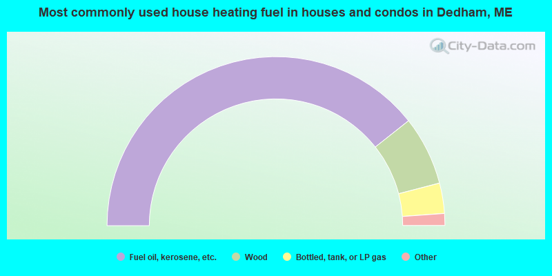
- 78.7%Fuel oil, kerosene, etc.
- 13.2%Wood
- 5.8%Bottled, tank, or LP gas
- 1.0%Electricity
- 0.8%Other fuel
- 0.4%Utility gas
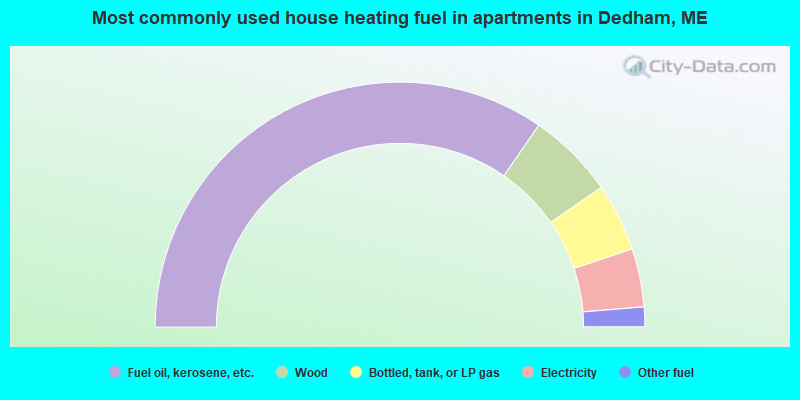
- 69.2%Fuel oil, kerosene, etc.
- 11.5%Wood
- 9.0%Bottled, tank, or LP gas
- 7.7%Electricity
- 2.6%Other fuel
Dedham compared to Maine state average:
- Unemployed percentage significantly below state average.
- Black race population percentage significantly below state average.
- Hispanic race population percentage below state average.
- Foreign-born population percentage significantly below state average.
- Renting percentage significantly below state average.
- Length of stay since moving in significantly above state average.
- Number of rooms per house significantly below state average.
- House age significantly below state average.
- Number of college students below state average.

|
Total of 3 patent applications in 2008-2024.