Hamburg, Alabama
Submit your own pictures of this place and show them to the world
- OSM Map
- General Map
- Google Map
- MSN Map

| Males: 257 | |
| Females: 295 |
| Median resident age: | 37.0 years |
| Alabama median age: | 35.8 years |
Zip code: 36756
| Hamburg: | $46,601 |
| AL: | $59,674 |
Estimated per capita income in 2022: $16,605 (it was $10,823 in 2000)
Hamburg CCD income, earnings, and wages data
Estimated median house or condo value in 2022: $57,415 (it was $24,600 in 2000)
| Hamburg: | $57,415 |
| AL: | $200,900 |
Mean prices in 2022: all housing units: $111,261; detached houses: $142,263; mobile homes: $55,183
Detailed information about poverty and poor residents in Hamburg, AL


- 41468.1%Black alone
- 18229.9%White alone
- 71.2%Hispanic
- 40.7%Two or more races
- 10.2%Asian alone

 Recent articles from our blog. Our writers, many of them Ph.D. graduates or candidates, create easy-to-read articles on a wide variety of topics.
Current Local Time: CST time zone
Land area: 79.3 square miles.
Population density: 7.0 people per square mile (very low).

| Hamburg CCD: | 1.0% ($255) |
| Alabama: | 0.4% ($289) |
Nearest city with pop. 50,000+: Tuscaloosa, AL  (46.6 miles , pop. 77,906).
Nearest city with pop. 200,000+: Montgomery, AL (62.0 miles , pop. 201,568).
Nearest city with pop. 1,000,000+: Houston, TX (515.0 miles , pop. 1,953,631).
Nearest cities:
), ), ), ), ), )Latitude: 32.56 N, Longitude: 87.32 W
Area code commonly used in this area: 334


| Here: | 5.1% |
| Alabama: | 2.6% |

- Educational services (19.5%)
- Truck transportation (10.0%)
- Agriculture, forestry, fishing & hunting (8.9%)
- Construction (8.4%)
- Health care (8.4%)
- Accommodation & food services (7.9%)
- Textile mills & textile products (5.8%)

- Educational services (19.8%)
- Truck transportation (18.8%)
- Agriculture, forestry, fishing & hunting (16.8%)
- Construction (15.8%)
- Repair & maintenance (10.9%)
- Lumber & other construction materials merchant wholesalers (9.9%)
- Metal & metal products (7.9%)

- Educational services (19.1%)
- Health care (18.0%)
- Accommodation & food services (16.9%)
- Textile mills & textile products (12.4%)
- Building material & garden equipment & supplies dealers (11.2%)
- Paper (10.1%)
- Wood products (6.7%)

- Driver/sales workers and truck drivers (10.0%)
- Farmers and farm managers (8.9%)
- Supervisors, construction and extraction workers (8.4%)
- Waiters and waitresses (7.9%)
- Building and grounds cleaning and maintenance occupations (5.8%)
- Nursing, psychiatric, and home health aides (5.8%)
- Vehicle and mobile equipment mechanics, installers, and repairers (5.8%)

- Driver/sales workers and truck drivers (18.8%)
- Farmers and farm managers (16.8%)
- Supervisors, construction and extraction workers (15.8%)
- Building and grounds cleaning and maintenance occupations (10.9%)
- Vehicle and mobile equipment mechanics, installers, and repairers (10.9%)
- Laborers and material movers, hand (9.9%)
- Bus drivers (8.9%)

- Waiters and waitresses (16.9%)
- Nursing, psychiatric, and home health aides (12.4%)
- Textile, apparel, and furnishings workers (12.4%)
- Retail sales workers, except cashiers (11.2%)
- Preschool, kindergarten, elementary, and middle school teachers (10.1%)
- Other management occupations, except farmers and farm managers (9.0%)
- Assemblers and fabricators (6.7%)
Average climate in Hamburg, Alabama
Based on data reported by over 4,000 weather stations


Tornado activity:
Hamburg-area historical tornado activity is slightly below Alabama state average. It is 48% greater than the overall U.S. average.
On 5/27/1973, a category F4 (max. wind speeds 207-260 mph) tornado 28.3 miles away from the Hamburg place center killed 7 people and injured 199 people and caused between $5,000,000 and $50,000,000 in damages.
On 3/1/2007, a category F4 tornado 30.8 miles away from the place center killed one person and injured 2 people and caused $2 million in damages.
Earthquake activity:
Hamburg-area historical earthquake activity is significantly above Alabama state average. It is 107% greater than the overall U.S. average.On 1/18/1999 at 07:00:53, a magnitude 4.8 (4.8 MB, 4.0 LG, Depth: 0.6 mi, Class: Light, Intensity: IV - V) earthquake occurred 58.7 miles away from Hamburg center
On 10/24/1997 at 08:35:17, a magnitude 4.9 (4.8 MB, 4.2 MS, 4.9 LG, Depth: 6.2 mi) earthquake occurred 99.3 miles away from Hamburg center
On 11/7/2004 at 11:20:21, a magnitude 4.3 (4.3 MW, Depth: 3.1 mi) earthquake occurred 36.6 miles away from Hamburg center
On 4/29/2003 at 08:59:39, a magnitude 4.9 (4.4 MB, 4.6 MW, 4.9 LG) earthquake occurred 165.5 miles away from Hamburg center
On 6/24/1975 at 11:11:36, a magnitude 4.5 (4.5 MB) earthquake occurred 85.9 miles away from the city center
On 4/29/2003 at 08:59:39, a magnitude 4.6 (4.6 MW, Depth: 12.3 mi) earthquake occurred 165.4 miles away from the city center
Magnitude types: regional Lg-wave magnitude (LG), body-wave magnitude (MB), surface-wave magnitude (MS), moment magnitude (MW)
Natural disasters:
The number of natural disasters in Perry County (18) is near the US average (15).Major Disasters (Presidential) Declared: 10
Emergencies Declared: 5
Causes of natural disasters: Storms: 8, Floods: 7, Hurricanes: 7, Tornadoes: 6, Winds: 6, Drought: 1, Snowfall: 1, Winter Storm: 1, Other: 1 (Note: some incidents may be assigned to more than one category).
Colleges/universities with over 2000 students nearest to Hamburg:
- Shelton State Community College (about 42 miles; Tuscaloosa, AL; Full-time enrollment: 4,106)
- University of Montevallo (about 47 miles; Montevallo, AL; FT enrollment: 2,826)
- The University of Alabama (about 48 miles; Tuscaloosa, AL; FT enrollment: 30,931)
- University of West Alabama (about 51 miles; Livingston, AL; FT enrollment: 3,394)
- Alabama State University (about 61 miles; Montgomery, AL; FT enrollment: 5,457)
- Faulkner University (about 66 miles; Montgomery, AL; FT enrollment: 2,887)
- Lawson State Community College-Birmingham Campus (about 67 miles; Birmingham, AL; FT enrollment: 2,695)
Points of interest:
Notable locations in Hamburg: Lakeland Farms (A), Hamburg Volunteer Fire Department (B). Display/hide their locations on the map
Churches in Hamburg include: Missionary Church (A), Bethel Church (B), Coles Chapel (C), Eagle Grove Church (D), Faith Chapel (E), Green Liberty Church (F), Greenleaf Church (G), Healing Springs Church (H), Lillie Grove Church (I). Display/hide their locations on the map
Cemeteries: Midway Cemetery (1), Friendship Cemetery (2). Display/hide their locations on the map
Reservoirs: Lake Heart (A), Lake Rhoda (B), Lake Sam (C), Lake Hugh (D), Lake Betty (E), Lake Beth (F), Lake Miriam (G), Lake Lou (H). Display/hide their locations on the map
Streams, rivers, and creeks: Rice Creek (A), Sand Creek (B), Piney Ridge Branch (C), Bingham Creek (D). Display/hide their locations on the map
| This place: | 2.4 people |
| Alabama: | 2.5 people |
| This place: | 71.1% |
| Whole state: | 67.8% |
| This place: | 4.1% |
| Whole state: | 4.7% |
No gay or lesbian households reported
| This place: | 36.3% |
| Whole state: | 16.1% |
| This place: | 16.2% |
| Whole state: | 7.3% |
For population 15 years and over in Hamburg:

- Never married: 31.2%
- Now married: 58.9%
- Separated: 6.2%
- Widowed: 4.6%
- Divorced: 5.3%
For population 25 years and over in Hamburg:
- High school or higher: 65.3%
- Bachelor's degree or higher: 9.0%
- Graduate or professional degree: 9.0%
- Unemployed: 5.9%
- Mean travel time to work (commute): 32.2 minutes


| Here: | 15.3 |
| Alabama average: | 13.2 |
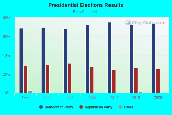
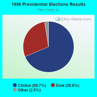
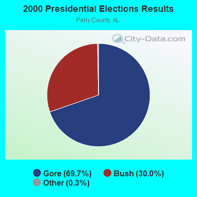

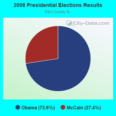
Graphs represent county-level data. Detailed 2008 Election Results
Religion statistics for Hamburg, AL (based on Perry County data)
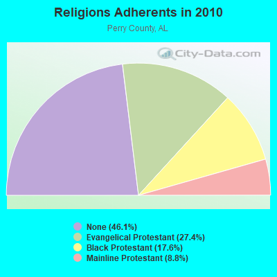
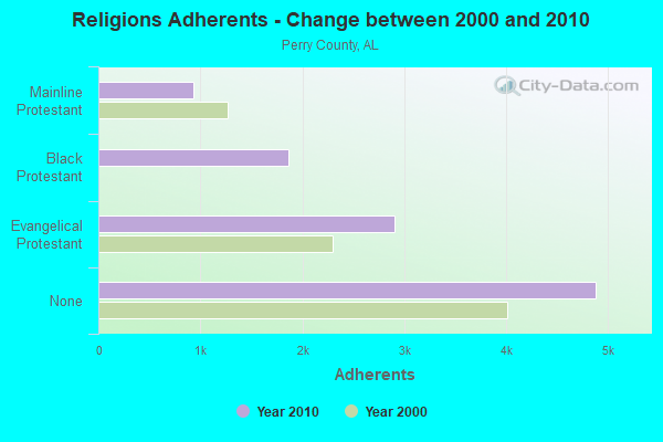
| Religion | Adherents | Congregations |
|---|---|---|
| Evangelical Protestant | 2,905 | 21 |
| Black Protestant | 1,864 | 11 |
| Mainline Protestant | 936 | 12 |
| Other | 5 | - |
| None | 4,881 | - |
Food Environment Statistics:
| Here: | 3.73 / 10,000 pop. |
| Alabama: | 1.89 / 10,000 pop. |
| Perry County: | 0.93 / 10,000 pop. |
| Alabama: | 0.65 / 10,000 pop. |
| Perry County: | 5.59 / 10,000 pop. |
| State: | 6.32 / 10,000 pop. |
| Perry County: | 4.66 / 10,000 pop. |
| Alabama: | 5.75 / 10,000 pop. |
| This county: | 17.0% |
| State: | 11.8% |
| This county: | 40.2% |
| Alabama: | 31.7% |
| Perry County: | 5.4% |
| Alabama: | 13.5% |
Strongest AM radio stations in Hamburg:
- WJUS (1310 AM; 5 kW; MARION, AL; Owner: GRACE BAPTIST TEMPLE CHURCH)
- WJOX (690 AM; 50 kW; BIRMINGHAM, AL; Owner: CITADEL BROADCASTING COMPANY)
- WAPI (1070 AM; 50 kW; BIRMINGHAM, AL; Owner: CITADEL BROADCASTING COMPANY)
- WDJC (850 AM; 50 kW; BIRMINGHAM, AL; Owner: KIMTRON, INC.)
- WNSI (810 AM; 50 kW; JACKSONVILLE, AL; Owner: UNITED BROADCASTING NETWORK, INC.)
- WASG (550 AM; 25 kW; ATMORE, AL; Owner: 550 AM, INC)
- WTSK (790 AM; 5 kW; TUSCALOOSA, AL; Owner: APEX BROADCASTING INC.)
- WMSP (740 AM; 10 kW; MONTGOMERY, AL; Owner: CUMULUS LICENSING CORP.)
- WCPC (940 AM; 50 kW; HOUSTON, MS; Owner: WCPC BROADCASTING CO., INC.)
- WSJC (810 AM; 50 kW; MAGEE, MS; Owner: FAMILY TALK RADIO)
- WACV (1170 AM; 10 kW; MONTGOMERY, AL; Owner: MONTGOMERY BROADCAST PROPERTIES, LTD)
- WKNG (1060 AM; daytime; 50 kW; TALLAPOOSA, GA; Owner: WKNG, INC.)
- WYLS (670 AM; daytime; 5 kW; YORK, AL; Owner: GRANTELL BROADCASTING COMPANY)
Strongest FM radio stations in Hamburg:
- WVFG (107.5 FM; UNIONTOWN, AL; Owner: CHARLES E. JONES, JR.)
- WNPT-FM (102.9 FM; LINDEN, AL; Owner: BECKHAM PALMER III AS RECEIVER)
- WJAM-FM (97.3 FM; ORRVILLE, AL; Owner: SCOTT COMMUNICATIONS, INC.)
- WBFZ (105.3 FM; SELMA, AL; Owner: IMANI COMMUNICATIONS CORPORATION, INC)
- WAPR (88.3 FM; SELMA, AL; Owner: UA-ASU-TSU EDUCATIONAL RADIO CORP.)
- WALX (100.9 FM; SELMA, AL; Owner: ALEXANDER BROADCASTING COMPANY, INC.)
- WDXB (102.5 FM; JASPER, AL; Owner: CAPSTAR TX LIMITED PARTNERSHIP)
- WTUG-FM (92.9 FM; TUSCALOOSA, AL; Owner: APEX BROADCASTING INC.)
- WANZ (100.7 FM; NORTHPORT, AL; Owner: APEX BRAODCASTING INC.)
- WDGM (99.1 FM; GREENSBORO, AL; Owner: WARRIOR BROADCASTING INC.)
- WAQU (91.1 FM; SELMA, AL; Owner: AMERICAN FAMILY ASSOCIATION)
- WBHJ (95.7 FM; TUSCALOOSA, AL; Owner: CXR HOLDINGS, INC.)
- WINL (98.5 FM; LINDEN, AL; Owner: WEST ALABAMA COMMUNICATIONS, INC.)
- WDXX (100.1 FM; SELMA, AL; Owner: BROADSOUTH COMMUNICATIONS, INC.)
- WZNJ (106.5 FM; DEMOPOLIS, AL; Owner: ROSS COMMUNICATIONS, INC.)
- W232AN (94.3 FM; SELMA, AL; Owner: THE MOODY BIBLE INSTITUTE OF CHICAGO)
TV broadcast stations around Hamburg:
- WBIH (Channel 29; SELMA, AL; Owner: FLINN BROADCASTING CORPORATION)
- WAKA (Channel 8; SELMA, AL; Owner: ALABAMA BROADCASTING PARTNERS)
- WIIQ (Channel 41; DEMOPOLIS, AL; Owner: ALABAMA EDUCATIONAL TELEVISION COMMISSION)
- WJMY-CA (Channel 28; DEMOPOLIS, AL; Owner: TTI, INC.)
- WDVZ-CA (Channel 3; GREENSBORO, AL; Owner: TTI, INC.)
- WLDM (Channel 23; TUSCALOOSA, AL; Owner: CHANNEL 23, LLC)
- W24CK (Channel 24; SELMA, AL; Owner: TRINITY BROADCASTING NETWORK)

- 64.1%Bottled, tank, or LP gas
- 19.8%Electricity
- 11.4%Utility gas
- 4.8%Wood

- 56.6%Electricity
- 30.2%Bottled, tank, or LP gas
- 13.2%Utility gas
Hamburg compared to Alabama state average:
- Median house value significantly below state average.
- Unemployed percentage below state average.
- Black race population percentage above state average.
- Hispanic race population percentage significantly below state average.
- Median age below state average.
- Foreign-born population percentage significantly below state average.
- Length of stay since moving in significantly above state average.
- Number of rooms per house significantly below state average.
- House age significantly below state average.
- Number of college students significantly below state average.
- Percentage of population with a bachelor's degree or higher below state average.