Safford, Alabama
Submit your own pictures of this place and show them to the world
- OSM Map
- General Map
- Google Map
- MSN Map

| Males: 309 | |
| Females: 333 |
| Median resident age: | 39.0 years |
| Alabama median age: | 35.8 years |
Zip code: 36773
| Safford: | $18,582 |
| AL: | $59,674 |
Estimated per capita income in 2022: $14,907 (it was $8,803 in 2000)
Safford CCD income, earnings, and wages data
Estimated median house or condo value in 2022: $61,978 (it was $34,500 in 2000)
| Safford: | $61,978 |
| AL: | $200,900 |
Mean prices in 2022: all housing units: $166,934; detached houses: $199,891; townhouses or other attached units: $50,935; in 2-unit structures: $87,751; in 3-to-4-unit structures: $130,889; mobile homes: $78,420
Detailed information about poverty and poor residents in Safford, AL


- 51073.5%Black alone
- 17525.2%White alone
- 81.2%Hispanic
- 10.1%Two or more races

 Recent articles from our blog. Our writers, many of them Ph.D. graduates or candidates, create easy-to-read articles on a wide variety of topics.
Current Local Time: CST time zone
Elevation: 228 feet
Land area: 152.2 square miles.
Population density: 4.2 people per square mile (very low).

| Safford CCD: | 0.6% ($199) |
| Alabama: | 0.4% ($289) |
Nearest city with pop. 50,000+: Tuscaloosa, AL  (62.7 miles , pop. 77,906).
Nearest city with pop. 200,000+: Montgomery, AL (63.5 miles , pop. 201,568).
Nearest city with pop. 1,000,000+: Houston, TX (506.7 miles , pop. 1,953,631).
Nearest cities:
), ), ), Latitude: 32.31 N, Longitude: 87.36 W
Area code commonly used in this area: 334


| Here: | 5.8% |
| Alabama: | 2.6% |

- Health care (14.7%)
- Educational services (14.0%)
- Repair & maintenance (13.3%)
- Construction (9.8%)
- Wood products (5.6%)
- Agriculture, forestry, fishing & hunting (4.9%)
- Farm product raw materials merchant wholesalers (4.9%)

- Repair & maintenance (22.6%)
- Construction (16.7%)
- Wood products (9.5%)
- Agriculture, forestry, fishing & hunting (8.3%)
- Farm product raw materials merchant wholesalers (8.3%)
- Used merchandise, gift, novelty, souvenir, other miscellaneous stores (8.3%)
- Fuel dealers (7.1%)

- Health care (35.6%)
- Educational services (23.7%)
- Food & beverage stores (11.9%)
- U. S. Postal service (11.9%)
- Professional, scientific, technical services (8.5%)
- Private households (8.5%)
- Apparel (0.0%)

- Building and grounds cleaning and maintenance occupations (12.6%)
- Nursing, psychiatric, and home health aides (11.2%)
- Preschool, kindergarten, elementary, and middle school teachers (9.1%)
- Vehicle and mobile equipment mechanics, installers, and repairers (7.7%)
- Other management occupations, except farmers and farm managers (5.6%)
- Woodworkers (5.6%)
- Laborers and material movers, hand (5.6%)

- Building and grounds cleaning and maintenance occupations (15.5%)
- Vehicle and mobile equipment mechanics, installers, and repairers (13.1%)
- Other management occupations, except farmers and farm managers (9.5%)
- Woodworkers (9.5%)
- Laborers and material movers, hand (9.5%)
- Agricultural workers, including supervisors (8.3%)
- Electrical equipment mechanics and other installation, maintenance, and repair workers, including supervisors (8.3%)

- Nursing, psychiatric, and home health aides (27.1%)
- Preschool, kindergarten, elementary, and middle school teachers (11.9%)
- Cashiers (11.9%)
- Material recording, scheduling, dispatching, and distributing workers (11.9%)
- Secretaries and administrative assistants (11.9%)
- Health technologists and technicians (8.5%)
- Building and grounds cleaning and maintenance occupations (8.5%)
Average climate in Safford, Alabama
Based on data reported by over 4,000 weather stations


Tornado activity:
Safford-area historical tornado activity is below Alabama state average. It is 30% greater than the overall U.S. average.
On 3/1/2007, a category F4 (max. wind speeds 207-260 mph) tornado 13.5 miles away from the Safford place center killed one person and injured 2 people and caused $2 million in damages.
On 5/27/1973, a category F4 tornado 29.6 miles away from the place center killed 7 people and injured 199 people and caused between $5,000,000 and $50,000,000 in damages.
Earthquake activity:
Safford-area historical earthquake activity is significantly above Alabama state average. It is 98% greater than the overall U.S. average.On 10/24/1997 at 08:35:17, a magnitude 4.9 (4.8 MB, 4.2 MS, 4.9 LG, Depth: 6.2 mi, Class: Light, Intensity: IV - V) earthquake occurred 82.3 miles away from the city center
On 1/18/1999 at 07:00:53, a magnitude 4.8 (4.8 MB, 4.0 LG, Depth: 0.6 mi) earthquake occurred 76.0 miles away from the city center
On 11/7/2004 at 11:20:21, a magnitude 4.3 (4.3 MW, Depth: 3.1 mi) earthquake occurred 40.6 miles away from Safford center
On 4/29/2003 at 08:59:39, a magnitude 4.9 (4.4 MB, 4.6 MW, 4.9 LG) earthquake occurred 181.2 miles away from the city center
On 6/24/1975 at 11:11:36, a magnitude 4.5 (4.5 MB) earthquake occurred 101.2 miles away from the city center
On 4/29/2003 at 08:59:39, a magnitude 4.6 (4.6 MW, Depth: 12.3 mi) earthquake occurred 181.2 miles away from Safford center
Magnitude types: regional Lg-wave magnitude (LG), body-wave magnitude (MB), surface-wave magnitude (MS), moment magnitude (MW)
Natural disasters:
The number of natural disasters in Dallas County (19) is greater than the US average (15).Major Disasters (Presidential) Declared: 11
Emergencies Declared: 5
Causes of natural disasters: Storms: 10, Floods: 8, Tornadoes: 7, Hurricanes: 6, Winds: 3, Drought: 1, Snowfall: 1, Winter Storm: 1, Other: 1 (Note: some incidents may be assigned to more than one category).
Colleges/universities with over 2000 students nearest to Safford:
- University of West Alabama (about 52 miles; Livingston, AL; Full-time enrollment: 3,394)
- Shelton State Community College (about 58 miles; Tuscaloosa, AL; FT enrollment: 4,106)
- University of Montevallo (about 63 miles; Montevallo, AL; FT enrollment: 2,826)
- Alabama State University (about 63 miles; Montgomery, AL; FT enrollment: 5,457)
- The University of Alabama (about 64 miles; Tuscaloosa, AL; FT enrollment: 30,931)
- Faulkner University (about 68 miles; Montgomery, AL; FT enrollment: 2,887)
- Auburn University at Montgomery (about 70 miles; Montgomery, AL; FT enrollment: 4,092)
Points of interest:
Notable location: Safford Community Volunteer Fire Department (A). Display/hide its location on the map
Churches in Safford include: New Hebron Church (A), New Hope Church (B), Pine Grove Church (C), Saint James Church (D), Saints Chapel (E), Spring Hill Church (F), Star Bethel Church (G), Trinity Church (H), Aimwell Church (I). Display/hide their locations on the map
Cemeteries: Mount Zion Cemetery (1), Christian Light Cemetery (2), Saint John Cemetery (3), New Hope Cemetery (4), Athens Cemetery (5), Saint Chapter Cemetery (6), Martins Station Cemetery (7). Display/hide their locations on the map
Reservoirs: Bon Aire Lake (A), Weissinger Lakes (B), Marion Weissinger Lake Number 2 (C), Marion Weissinger Lake Number One (D), W W Weissinger Number 4 Lake (E), F W Pierce Lake Number 2 (F), W W Weissinger Number 2 Lake (G), C A Caines Lake (H). Display/hide their locations on the map
Streams, rivers, and creeks: Tayloe Creek (A), Sand Creek (B), Rogers Creek (C), Mud Creek (D), Lize Creek (E), Hogan Creek (F), Glover Creek (G), Freetown Creek (H), English Creek (I). Display/hide their locations on the map
| This place: | 2.4 people |
| Alabama: | 2.5 people |
| This place: | 57.9% |
| Whole state: | 67.8% |
| This place: | 3.8% |
| Whole state: | 4.7% |
Likely homosexual households (counted as self-reported same-sex unmarried-partner households)
- Lesbian couples: 0.9% of all households
- Gay men: 0.4% of all households
| This place: | 47.0% |
| Whole state: | 16.1% |
| This place: | 15.6% |
| Whole state: | 7.3% |
For population 15 years and over in Safford:

- Never married: 40.3%
- Now married: 33.0%
- Separated: 4.7%
- Widowed: 14.4%
- Divorced: 12.3%
For population 25 years and over in Safford:
- High school or higher: 45.5%
- Bachelor's degree or higher: 5.9%
- Graduate or professional degree: 1.5%
- Unemployed: 12.8%
- Mean travel time to work (commute): 31.3 minutes


| Here: | 12.6 |
| Alabama average: | 13.2 |
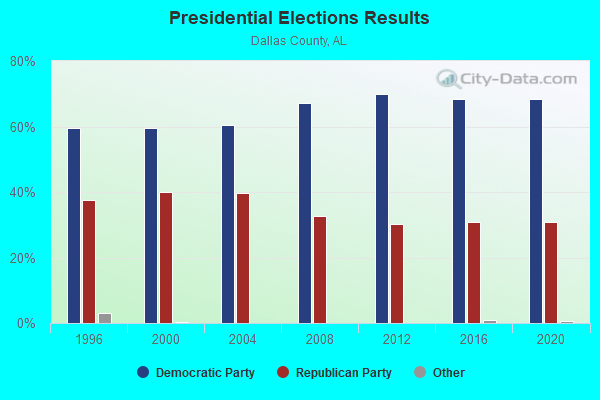
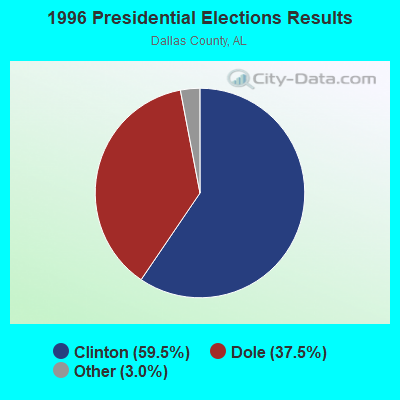
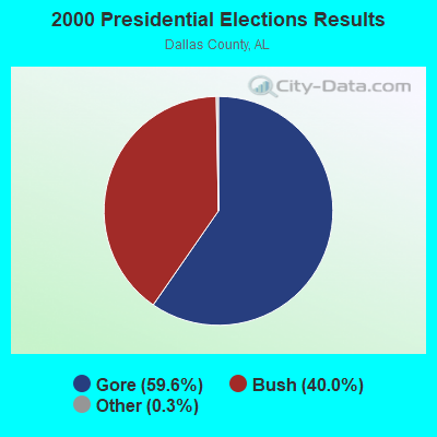
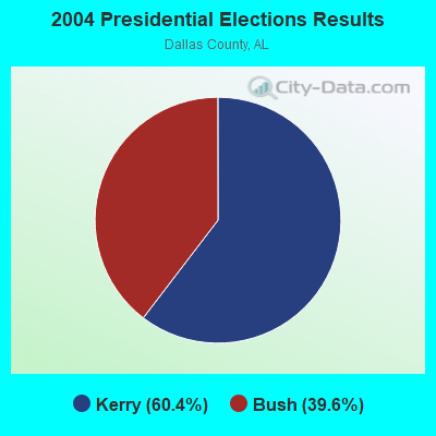

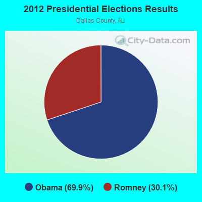
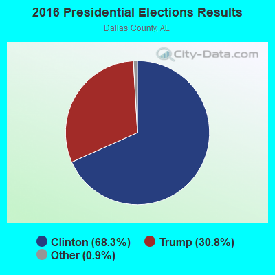
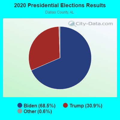
Graphs represent county-level data. Detailed 2008 Election Results
Religion statistics for Safford, AL (based on Dallas County data)
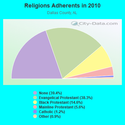
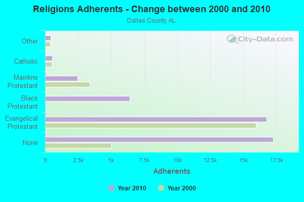
| Religion | Adherents | Congregations |
|---|---|---|
| Evangelical Protestant | 16,764 | 73 |
| Black Protestant | 6,398 | 34 |
| Mainline Protestant | 2,438 | 26 |
| Catholic | 536 | 2 |
| Other | 410 | 5 |
| None | 17,274 | - |
Food Environment Statistics:
| Dallas County: | 2.56 / 10,000 pop. |
| Alabama: | 1.89 / 10,000 pop. |
| Dallas County: | 0.23 / 10,000 pop. |
| Alabama: | 0.20 / 10,000 pop. |
| Dallas County: | 0.93 / 10,000 pop. |
| Alabama: | 0.65 / 10,000 pop. |
| Dallas County: | 9.54 / 10,000 pop. |
| State: | 6.32 / 10,000 pop. |
| Here: | 3.95 / 10,000 pop. |
| Alabama: | 5.75 / 10,000 pop. |
| Dallas County: | 15.1% |
| Alabama: | 11.8% |
| Here: | 41.2% |
| Alabama: | 31.7% |
| This county: | 8.9% |
| Alabama: | 13.5% |
Strongest AM radio stations in Safford:
- WJOX (690 AM; 50 kW; BIRMINGHAM, AL; Owner: CITADEL BROADCASTING COMPANY)
- WJUS (1310 AM; 5 kW; MARION, AL; Owner: GRACE BAPTIST TEMPLE CHURCH)
- WDJC (850 AM; 50 kW; BIRMINGHAM, AL; Owner: KIMTRON, INC.)
- WAPI (1070 AM; 50 kW; BIRMINGHAM, AL; Owner: CITADEL BROADCASTING COMPANY)
- WASG (550 AM; 25 kW; ATMORE, AL; Owner: 550 AM, INC)
- WSJC (810 AM; 50 kW; MAGEE, MS; Owner: FAMILY TALK RADIO)
- WNSI (810 AM; 50 kW; JACKSONVILLE, AL; Owner: UNITED BROADCASTING NETWORK, INC.)
- WMSP (740 AM; 10 kW; MONTGOMERY, AL; Owner: CUMULUS LICENSING CORP.)
- WCPC (940 AM; 50 kW; HOUSTON, MS; Owner: WCPC BROADCASTING CO., INC.)
- WYLS (670 AM; daytime; 5 kW; YORK, AL; Owner: GRANTELL BROADCASTING COMPANY)
- WACV (1170 AM; 10 kW; MONTGOMERY, AL; Owner: MONTGOMERY BROADCAST PROPERTIES, LTD)
- WGST (640 AM; 50 kW; ATLANTA, GA; Owner: CITICASTERS LICENSES, L.P.)
- WKNG (1060 AM; daytime; 50 kW; TALLAPOOSA, GA; Owner: WKNG, INC.)
Strongest FM radio stations in Safford:
- WVFG (107.5 FM; UNIONTOWN, AL; Owner: CHARLES E. JONES, JR.)
- WBFZ (105.3 FM; SELMA, AL; Owner: IMANI COMMUNICATIONS CORPORATION, INC)
- WJAM-FM (97.3 FM; ORRVILLE, AL; Owner: SCOTT COMMUNICATIONS, INC.)
- WINL (98.5 FM; LINDEN, AL; Owner: WEST ALABAMA COMMUNICATIONS, INC.)
- WAPR (88.3 FM; SELMA, AL; Owner: UA-ASU-TSU EDUCATIONAL RADIO CORP.)
- WNPT-FM (102.9 FM; LINDEN, AL; Owner: BECKHAM PALMER III AS RECEIVER)
- WKXK (96.7 FM; PINE HILL, AL; Owner: AUTAUGAVILLE RADIO, INC.)
- WALX (100.9 FM; SELMA, AL; Owner: ALEXANDER BROADCASTING COMPANY, INC.)
- WMBV (91.9 FM; DIXONS MILLS, AL; Owner: THE MOODY BIBLE INSTITUTE OF CHICAGO)
- WZNJ (106.5 FM; DEMOPOLIS, AL; Owner: ROSS COMMUNICATIONS, INC.)
- WAQU (91.1 FM; SELMA, AL; Owner: AMERICAN FAMILY ASSOCIATION)
- WDXX (100.1 FM; SELMA, AL; Owner: BROADSOUTH COMMUNICATIONS, INC.)
- WYVC (102.3 FM; CAMDEN, AL; Owner: DOWN HOME BROADCASTING)
TV broadcast stations around Safford:
- WAKA (Channel 8; SELMA, AL; Owner: ALABAMA BROADCASTING PARTNERS)
- WBIH (Channel 29; SELMA, AL; Owner: FLINN BROADCASTING CORPORATION)
- WIIQ (Channel 41; DEMOPOLIS, AL; Owner: ALABAMA EDUCATIONAL TELEVISION COMMISSION)
- W24CK (Channel 24; SELMA, AL; Owner: TRINITY BROADCASTING NETWORK)
- National Bridge Inventory (NBI) Statistics
- 9Number of bridges
- 210ft / 64.0mTotal length
- $24,119,000Total costs
- 22,570Total average daily traffic
- 5,796Total average daily truck traffic
- 29,508Total future (year 2033) average daily traffic
FCC Registered Cell Phone Towers:
1 (See the full list of FCC Registered Cell Phone Towers in Safford)FCC Registered Antenna Towers:
40 (See the full list of FCC Registered Antenna Towers)FCC Registered Private Land Mobile Towers:
2- Hwy 5 2 Km Ne (Lat: 32.288750 Lon: -87.371389), Type: Tower, Structure height: 117 m, Call Sign: WPFR686,
Assigned Frequencies: 858.812 MHz, 858.862 MHz, 858.887 MHz, 858.912 MHz, 859.287 MHz, 859.312 MHz, 859.337 MHz, 859.362 MHz, 859.387 MHz, 859.412 MHz... (+10 more), Grant Date: 11/19/2019, Expiration Date: 09/30/2029, Registrant: Southern Communications Services, Inc D/B/A Southern Linc, 600 18th St N Bin Sn-0800, Birmingham, AL 35203-2206, Phone: (205) 257-1534, Email:
- Hwy 5 2 Km Ne (Lat: 32.288750 Lon: -87.371389), Type: Tower, Structure height: 117 m, Call Sign: WQJM742,
Assigned Frequencies: 855.162 MHz, Grant Date: 09/01/2009, Expiration Date: 09/30/2019, Cancellation Date: 12/23/2013, Certifier: Robin J Cohen, Registrant: Sprint Nextel Corporation, 12502 Sunrise Valley Drive, Reston, VA 20191, Phone: (703) 433-4000, Fax: (703) 433-4483
FCC Registered Microwave Towers:
5- SAFFORD, 4761 County Road 109 (Safford - 100046212) (Lat: 32.306639 Lon: -87.370778), Type: Gtower, Structure height: 91.4 m, Overall height: 92.3 m, Call Sign: WQQW243,
Assigned Frequencies: 6034.15 MHz, Grant Date: 03/13/2013, Expiration Date: 03/13/2023, Cancellation Date: 06/24/2014, Certifier: Charles Cleary, Registrant: Verizon Wireless, 1120 Sanctuary Pkwy #150 Gasa5reg, Alpharetta, GA 30009-7630, Phone: (770) 797-1070, Fax: (770) 797-1036, Email:
- SAFFORD, 1.2 Km Nw (Lat: 32.288889 Lon: -87.371389), Type: Gtower, Structure height: 106.7 m, Overall height: 116.7 m, Call Sign: WQZA494,
Assigned Frequencies: 10895.0 MHz, 10935.0 MHz, 11055.0 MHz, 11095.0 MHz, 10895.0 MHz, 10935.0 MHz, 11055.0 MHz, 11095.0 MHz, 10895.0 MHz, 10935.0 MHz... (+38 more), Grant Date: 03/21/2017, Expiration Date: 03/21/2027, Certifier: Larry F Butts, Registrant: Southern Company Services, 600 N. 18th St / Bin 5n-5409, Birmingham, AL 35203, Phone: (205) 257-7600, Fax: (205) 257-2134, Email:
- 9BH2547B, 1.2 Km Nw (Lat: 32.288889 Lon: -87.371389), Type: Ltower, Structure height: 106.7 m, Overall height: 116.7 m, Call Sign: WRJP837,
Assigned Frequencies: 11175.0 MHz, 11175.0 MHz, 11175.0 MHz, 11175.0 MHz, 11175.0 MHz, 11175.0 MHz, 11175.0 MHz, 11175.0 MHz, 11175.0 MHz, 11175.0 MHz, Grant Date: 10/06/2020, Expiration Date: 10/06/2030, Certifier: David Werblow, Registrant: T-Mobile Usa, Inc., 12920 Se 38th Street, Bellevue, WA 98006, Phone: (425) 383-8401, Fax: (425) 383-4040, Email:
- ORRVILLE, 21435 Highway 22 West (Lat: 32.291083 Lon: -87.348861), Type: Gtower, Structure height: 108.5 m, Overall height: 110.9 m, Call Sign: WRJP841,
Assigned Frequencies: 6226.89 MHz, 6256.54 MHz, 6286.19 MHz, Grant Date: 10/06/2020, Expiration Date: 10/06/2030, Certifier: Kevin Hetrick, Registrant: At&t Services, Inc., 208 S Akard St, 20f, Dallas, TX 75202, Phone: (855) 699-7073, Email:
- SAFFORD ALLTEL, 4761 County Road 109 (Safford - 100046212) (Lat: 32.306639 Lon: -87.370778), Type: Gtower, Structure height: 91.4 m, Overall height: 92.3 m, Call Sign: WRKI676,
Assigned Frequencies: 10775.0 MHz, 10815.0 MHz, 10775.0 MHz, 10815.0 MHz, 10775.0 MHz, 10815.0 MHz, 10775.0 MHz, 10815.0 MHz, 10775.0 MHz, 10815.0 MHz, Grant Date: 01/11/2021, Expiration Date: 01/11/2031, Certifier: Christophe Le Scanve, Registrant: Cellco Partnership, 5055 North Point Pkwy, Np2ne Network Engineering, Alpharetta, GA 30022, Phone: (770) 797-1070, Email:
FAA Registered Aircraft:
2- Aircraft: CESSNA 177RG (Category: Land, Seats: 4, Weight: Up to 12,499 Pounds, Speed: 120 mph), Engine: LYCOMING IO-360-A1B6D (200 HP) (Reciprocating)
N-Number: 34866, N34866, N-34866, Serial Number: 177RG1015, Year manufactured: 1976, Airworthiness Date: 09/17/1976, Certificate Issue Date: 04/30/2009
Registrant (Individual): Samuel P Givhan, 6900 Al Highway 5, Safford, AL 36773 - Aircraft: FLIGHT DESIGN GMBH CTLS (Category: Land, Seats: 2, Weight: Up to 12,499 Pounds), Engine: ROTAX 912IS2 (100 HP) (4 Cycle)
N-Number: 34885, N34885, N-34885, Serial Number: F-13-03-07, Year manufactured: 2014, Airworthiness Date: 07/10/2014, Certificate Issue Date: 08/28/2014
Registrant (Co-Owned): William B Virgin, Po Box 97, Safford, AL 36773, Other Owners: Linda S Virgin

- 52.8%Bottled, tank, or LP gas
- 27.1%Utility gas
- 20.2%Electricity

- 82.5%Bottled, tank, or LP gas
- 17.5%Wood
Safford compared to Alabama state average:
- Median household income significantly below state average.
- Median house value significantly below state average.
- Black race population percentage significantly above state average.
- Hispanic race population percentage significantly below state average.
- Median age below state average.
- Foreign-born population percentage significantly below state average.
- Length of stay since moving in significantly above state average.
- Number of rooms per house significantly below state average.
- House age significantly below state average.
- Percentage of population with a bachelor's degree or higher significantly below state average.