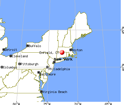
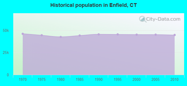
Enfield, Connecticut
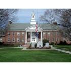
Enfield: THOMPSONVILLE SECTION OF ENFIELD, CT - TOWN HALL

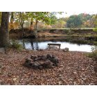
Enfield: Shed and Tobacco Barn (Broadbrook Rd. Enfield, CT)
Enfield: Scantic River
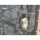
Enfield: backyard Hawk
- add
your


Submit your own pictures of this town and show them to the world
- OSM Map
- General Map
- Google Map
- MSN Map
Population change since 2000: -1.2%
 |
| Males: 23,359 | |
| Females: 21,295 |
| Median resident age: | 40.4 years |
| Connecticut median age: | 39.2 years |
Zip codes: 06082.
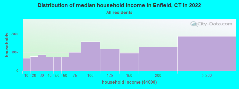
| Enfield: | $86,585 |
| CT: | $88,429 |
Estimated per capita income in 2022: $39,390 (it was $21,967 in 2000)
Enfield town income, earnings, and wages data
Estimated median house or condo value in 2022: $266,994 (it was $123,500 in 2000)
| Enfield: | $266,994 |
| CT: | $347,200 |
Mean prices in 2022: all housing units: $326,390; detached houses: $351,925; townhouses or other attached units: $238,893; in 2-unit structures: $226,606; in 3-to-4-unit structures: $205,937; in 5-or-more-unit structures: $157,099; mobile homes: $128,456
Detailed information about poverty and poor residents in Enfield, CT


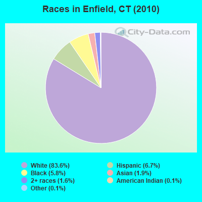
- 37,33683.6%White alone
- 3,0066.7%Hispanic
- 2,6115.8%Black alone
- 8641.9%Asian alone
- 7061.6%Two or more races
- 580.1%American Indian alone
- 580.1%Other race alone
- 150.03%Native Hawaiian and Other
Pacific Islander alone
Races in Enfield detailed stats: ancestries, foreign born residents, place of birth
According to our research of Connecticut and other state lists, there were 40 registered sex offenders living in Enfield, Connecticut as of May 13, 2024.
The ratio of all residents to sex offenders in Enfield is 1,116 to 1.
The ratio of registered sex offenders to all residents in this city is lower than the state average.
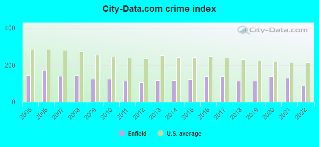
Type |
2009 |
2010 |
2011 |
2012 |
2013 |
2014 |
2015 |
2016 |
2017 |
2018 |
2019 |
2020 |
2021 |
2022 |
|---|---|---|---|---|---|---|---|---|---|---|---|---|---|---|
| Murders (per 100,000) | 0 (0.0) | 1 (2.2) | 1 (2.2) | 0 (0.0) | 0 (0.0) | 2 (4.5) | 0 (0.0) | 1 (2.3) | 0 (0.0) | 1 (2.2) | 1 (2.3) | 0 (0.0) | 2 (4.6) | 1 (2.4) |
| Rapes (per 100,000) | 0 (0.0) | 0 (0.0) | 0 (0.0) | 0 (0.0) | 1 (2.2) | 1 (2.2) | 10 (22.4) | 7 (15.8) | 6 (13.5) | 6 (13.5) | 15 (33.8) | 12 (27.6) | 10 (23.0) | 2 (4.8) |
| Robberies (per 100,000) | 20 (44.6) | 9 (20.2) | 19 (42.5) | 12 (26.8) | 19 (42.5) | 22 (49.1) | 16 (35.9) | 20 (45.2) | 21 (47.4) | 8 (17.9) | 6 (13.5) | 14 (32.1) | 14 (32.2) | 5 (11.9) |
| Assaults (per 100,000) | 28 (62.4) | 30 (67.2) | 18 (40.2) | 18 (40.2) | 30 (67.2) | 28 (62.5) | 26 (58.3) | 47 (106.2) | 52 (117.3) | 40 (89.7) | 32 (72.0) | 33 (75.8) | 43 (99.0) | 36 (85.9) |
| Burglaries (per 100,000) | 176 (392.4) | 197 (441.2) | 178 (397.9) | 198 (441.9) | 142 (318.0) | 131 (292.6) | 125 (280.2) | 161 (363.8) | 171 (385.8) | 144 (323.1) | 61 (137.3) | 124 (284.7) | 52 (119.7) | 33 (78.7) |
| Thefts (per 100,000) | 710 (1,583) | 667 (1,494) | 602 (1,346) | 591 (1,319) | 690 (1,545) | 588 (1,313) | 626 (1,403) | 574 (1,297) | 566 (1,277) | 491 (1,102) | 515 (1,159) | 629 (1,444) | 571 (1,314) | 453 (1,081) |
| Auto thefts (per 100,000) | 46 (102.5) | 51 (114.2) | 38 (84.9) | 31 (69.2) | 25 (56.0) | 41 (91.6) | 41 (91.9) | 51 (115.2) | 60 (135.4) | 52 (116.7) | 51 (114.8) | 75 (172.2) | 61 (140.4) | 46 (109.8) |
| Arson (per 100,000) | 6 (13.4) | 3 (6.7) | 5 (11.2) | 5 (11.2) | 0 (0.0) | 8 (17.9) | 1 (2.2) | 8 (18.1) | 0 (0.0) | 0 (0.0) | 2 (4.5) | 1 (2.3) | 0 (0.0) | 0 (0.0) |
| City-Data.com crime index | 124.8 | 123.7 | 113.7 | 105.3 | 116.5 | 118.3 | 123.4 | 138.5 | 137.4 | 114.6 | 115.1 | 138.3 | 129.2 | 86.9 |
The City-Data.com crime index weighs serious crimes and violent crimes more heavily. Higher means more crime, U.S. average is 246.1. It adjusts for the number of visitors and daily workers commuting into cities.
Crime rate in Enfield detailed stats: murders, rapes, robberies, assaults, burglaries, thefts, arson
Full-time law enforcement employees in 2021, including police officers: 119 (96 officers - 82 male; 14 female).
| Officers per 1,000 residents here: | 2.21 |
| Connecticut average: | 2.10 |
 Recent articles from our blog. Our writers, many of them Ph.D. graduates or candidates, create easy-to-read articles on a wide variety of topics.


Latest news from Enfield, CT collected exclusively by city-data.com from local newspapers, TV, and radio stations
Enfield, CT City Guides:
Ancestries: Irish (21.1%), Italian (18.2%), French (14.6%), Polish (13.0%), English (11.5%), German (9.6%).
Current Local Time: EST time zone
Incorporated in 1683
Elevation: 154 feet
Land area: 33.4 square miles.
Population density: 1,338 people per square mile (low).
2,191 residents are foreign born (2.1% Europe, 1.0% Latin America, 0.9% Asia, 0.7% North America).
| This town: | 4.8% |
| Connecticut: | 10.9% |
| Enfield town: | 2.0% ($2,483) |
| Connecticut: | 1.8% ($2,961) |
Nearest city with pop. 50,000+: Springfield, MA  (8.7 miles , pop. 152,082).
Nearest city with pop. 200,000+: Boston, MA (79.1 miles , pop. 589,141).
Nearest city with pop. 1,000,000+: Bronx, NY (104.1 miles , pop. 1,332,650).
Nearest cities:
), ), ), ), ), Latitude: 41.99 N, Longitude: 72.56 W
Area code: 860

Enfield, Connecticut accommodation & food services, waste management - Economy and Business Data
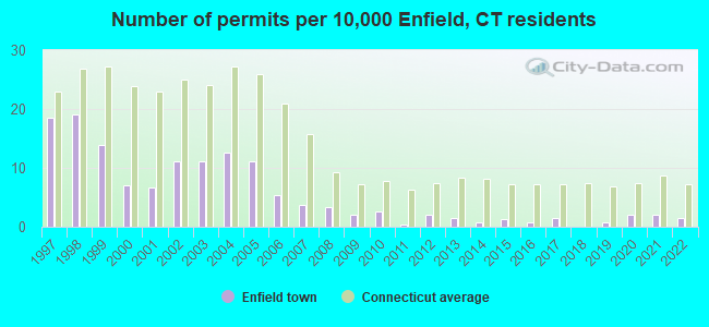
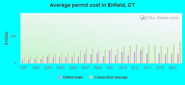
Single-family new house construction building permits:
- 2022: 7 buildings, average cost: $176,600
- 2021: 9 buildings, average cost: $177,200
- 2020: 9 buildings, average cost: $175,000
- 2019: 3 buildings, average cost: $185,000
- 2017: 7 buildings, average cost: $185,000
- 2016: 3 buildings, average cost: $247,600
- 2015: 6 buildings, average cost: $212,800
- 2014: 3 buildings, average cost: $151,700
- 2013: 7 buildings, average cost: $213,600
- 2012: 9 buildings, average cost: $156,300
- 2011: 2 buildings, average cost: $235,000
- 2010: 12 buildings, average cost: $138,300
- 2009: 9 buildings, average cost: $193,800
- 2008: 15 buildings, average cost: $168,400
- 2007: 17 buildings, average cost: $182,300
- 2006: 24 buildings, average cost: $130,300
- 2005: 50 buildings, average cost: $124,400
- 2004: 57 buildings, average cost: $122,200
- 2003: 50 buildings, average cost: $117,300
- 2002: 50 buildings, average cost: $118,500
- 2001: 30 buildings, average cost: $133,800
- 2000: 32 buildings, average cost: $85,000
- 1999: 63 buildings, average cost: $86,700
- 1998: 86 buildings, average cost: $73,300
- 1997: 84 buildings, average cost: $74,300
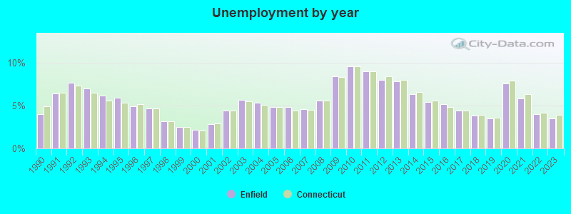
| Here: | 3.5% |
| Connecticut: | 3.9% |
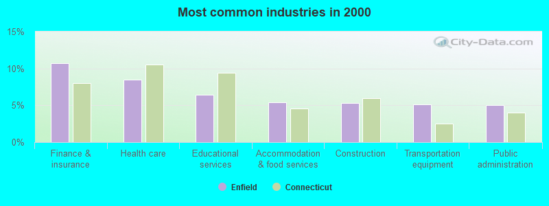
- Finance & insurance (10.7%)
- Health care (8.5%)
- Educational services (6.4%)
- Accommodation & food services (5.4%)
- Construction (5.3%)
- Transportation equipment (5.1%)
- Public administration (5.0%)
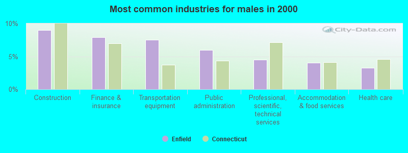
- Construction (9.0%)
- Finance & insurance (7.9%)
- Transportation equipment (7.5%)
- Public administration (6.0%)
- Professional, scientific, technical services (4.5%)
- Accommodation & food services (4.0%)
- Health care (3.3%)
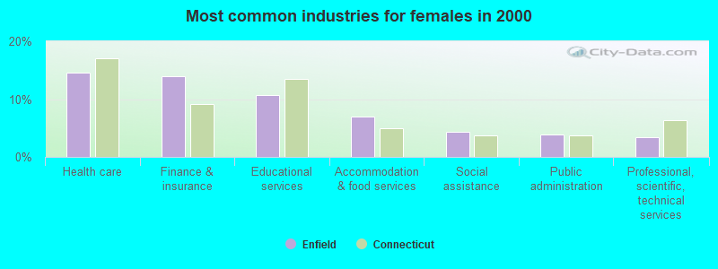
- Health care (14.5%)
- Finance & insurance (14.0%)
- Educational services (10.7%)
- Accommodation & food services (6.9%)
- Social assistance (4.3%)
- Public administration (4.0%)
- Professional, scientific, technical services (3.4%)
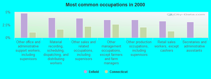
- Other office and administrative support workers, including supervisors (4.8%)
- Material recording, scheduling, dispatching, and distributing workers (3.9%)
- Other sales and related occupations, including supervisors (3.8%)
- Other management occupations, except farmers and farm managers (3.5%)
- Other production occupations, including supervisors (3.5%)
- Retail sales workers, except cashiers (3.2%)
- Secretaries and administrative assistants (3.1%)
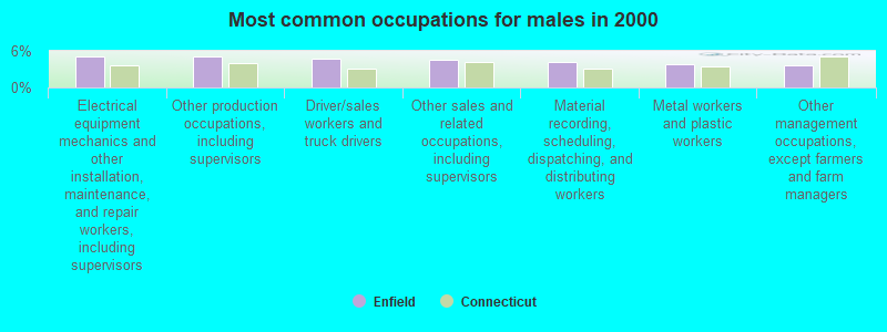
- Electrical equipment mechanics and other installation, maintenance, and repair workers, including supervisors (5.1%)
- Other production occupations, including supervisors (5.0%)
- Driver/sales workers and truck drivers (4.8%)
- Other sales and related occupations, including supervisors (4.6%)
- Material recording, scheduling, dispatching, and distributing workers (4.1%)
- Metal workers and plastic workers (3.8%)
- Other management occupations, except farmers and farm managers (3.7%)
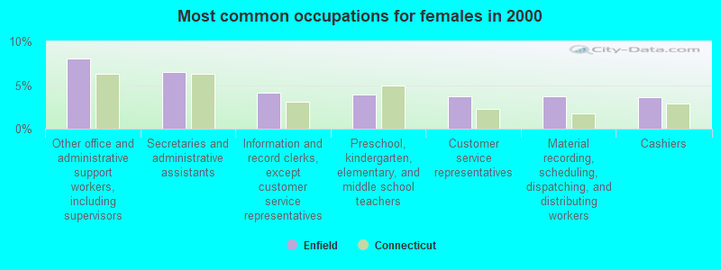
- Other office and administrative support workers, including supervisors (8.0%)
- Secretaries and administrative assistants (6.5%)
- Information and record clerks, except customer service representatives (4.1%)
- Preschool, kindergarten, elementary, and middle school teachers (4.0%)
- Customer service representatives (3.7%)
- Material recording, scheduling, dispatching, and distributing workers (3.7%)
- Cashiers (3.6%)
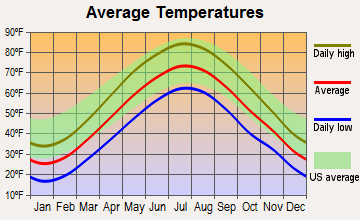
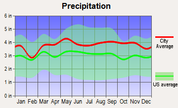
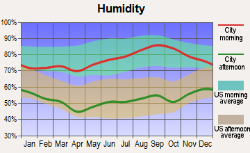
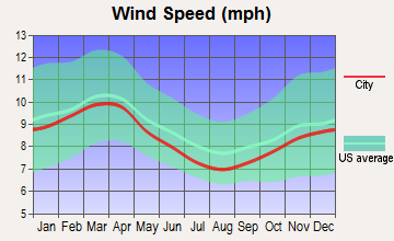
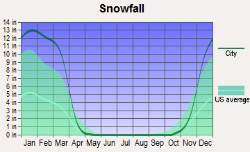
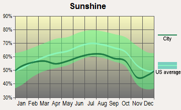
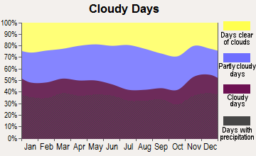
Average climate in Enfield, Connecticut
Based on data reported by over 4,000 weather stations
(lower is better)
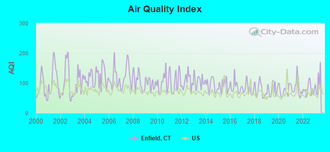
Air Quality Index (AQI) level in 2022 was 78.6. This is about average.
| City: | 78.6 |
| U.S.: | 72.6 |
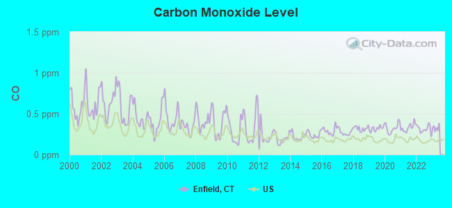
Carbon Monoxide (CO) [ppm] level in 2022 was 0.312. This is worse than average. Closest monitor was 0.9 miles away from the city center.
| City: | 0.312 |
| U.S.: | 0.251 |
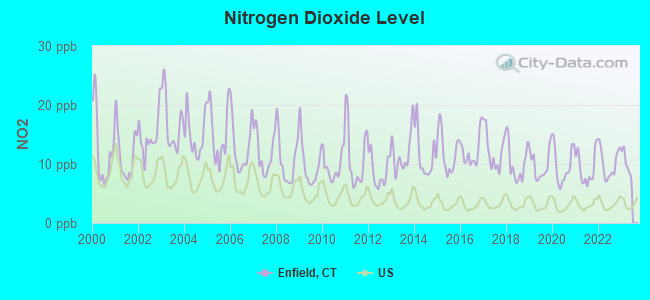
Nitrogen Dioxide (NO2) [ppb] level in 2022 was 10.1. This is significantly worse than average. Closest monitor was 0.9 miles away from the city center.
| City: | 10.1 |
| U.S.: | 5.1 |
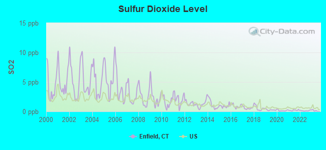
Sulfur Dioxide (SO2) [ppb] level in 2022 was 0.151. This is significantly better than average. Closest monitor was 0.9 miles away from the city center.
| City: | 0.151 |
| U.S.: | 1.515 |
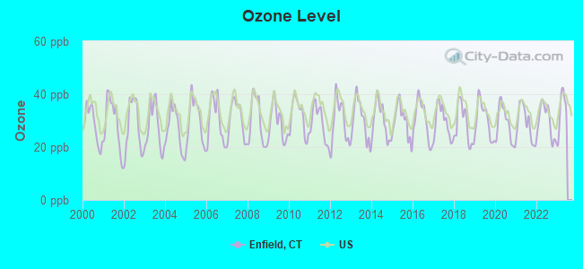
Ozone [ppb] level in 2022 was 29.7. This is about average. Closest monitor was 0.9 miles away from the city center.
| City: | 29.7 |
| U.S.: | 33.3 |
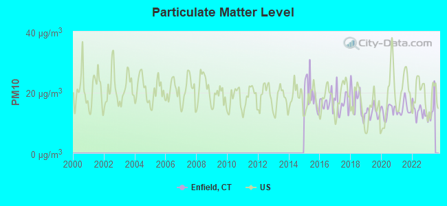
Particulate Matter (PM10) [µg/m3] level in 2022 was 13.8. This is better than average. Closest monitor was 3.1 miles away from the city center.
| City: | 13.8 |
| U.S.: | 19.2 |
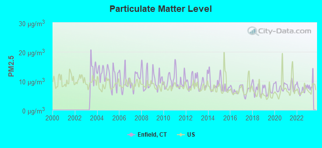
Particulate Matter (PM2.5) [µg/m3] level in 2022 was 7.23. This is about average. Closest monitor was 8.4 miles away from the city center.
| City: | 7.23 |
| U.S.: | 8.11 |
Tornado activity:
Enfield-area historical tornado activity is slightly above Connecticut state average. It is 12% smaller than the overall U.S. average.
On 10/3/1979, a category F4 (max. wind speeds 207-260 mph) tornado 8.2 miles away from the Enfield town center killed 3 people and injured 500 people and caused between $50,000,000 and $500,000,000 in damages.
On 5/10/1954, a category F3 (max. wind speeds 158-206 mph) tornado 6.7 miles away from the town center injured 2 people and caused between $5000 and $50,000 in damages.
Earthquake activity:
Enfield-area historical earthquake activity is significantly above Connecticut state average. It is 70% smaller than the overall U.S. average.On 10/7/1983 at 10:18:46, a magnitude 5.3 (5.1 MB, 5.3 LG, 5.1 ML, Class: Moderate, Intensity: VI - VII) earthquake occurred 163.0 miles away from the city center
On 4/20/2002 at 10:50:47, a magnitude 5.3 (5.3 ML, Depth: 3.0 mi) earthquake occurred 183.8 miles away from the city center
On 4/20/2002 at 10:50:47, a magnitude 5.2 (5.2 MB, 4.2 MS, 5.2 MW, 5.0 MW) earthquake occurred 182.4 miles away from Enfield center
On 1/19/1982 at 00:14:42, a magnitude 4.7 (4.5 MB, 4.7 MD, 4.5 LG, Class: Light, Intensity: IV - V) earthquake occurred 115.5 miles away from the city center
On 10/16/2012 at 23:12:25, a magnitude 4.7 (4.7 ML, Depth: 10.0 mi) earthquake occurred 147.6 miles away from Enfield center
On 8/23/2011 at 17:51:04, a magnitude 5.8 (5.8 MW, Depth: 3.7 mi) earthquake occurred 400.7 miles away from Enfield center
Magnitude types: regional Lg-wave magnitude (LG), body-wave magnitude (MB), duration magnitude (MD), local magnitude (ML), surface-wave magnitude (MS), moment magnitude (MW)
Natural disasters:
The number of natural disasters in Hartford County (24) is greater than the US average (15).Major Disasters (Presidential) Declared: 13
Emergencies Declared: 11
Causes of natural disasters: Storms: 7, Hurricanes: 5, Floods: 4, Snowstorms: 4, Blizzards: 3, Snows: 3, Tropical Storms: 2, Winter Storms: 2, Snowfall: 1, Tornado: 1, Wind: 1 (Note: some incidents may be assigned to more than one category).

Hospitals and medical centers in Enfield:
- C I B: AVON ST COMM RES (1 AVON STREET)
- BLAIR MANOR (612 HAZARD AVE)
- KINDRED TRANSITIONAL CARE AND REHAB-PARKWAY PAVILION (1157 ENFIELD ST)
- PARKWAY PAVILION HEALTHCARE (1157 ENFIELD ST)
- ST JOSEPH RESIDENCE (1365 ENFIELD ST)
- ENFIELD DIALYSIS CENTER (113 ELM STREET)
- HOME AND COMMUNITY HEALTH SERVICES, INC (101 PHOENIX AVENUE, 1ST FLOOR)
Heliports and other landing facilities located in Enfield:
See details about Heliports and other landing facilities located in Enfield, CTAmtrak stations near Enfield:
- 6 miles: WINDSOR LOCKS (S. MAIN ST. (RTE. 159)) . Services: public payphones, free short-term parking, free long-term parking, call for car rental service, call for taxi service, public transit connection.
- 9 miles: SPRINGFIELD (66 LYMAN ST.) . Services: ticket office, partially wheelchair accessible, enclosed waiting area, public restrooms, public payphones, full-service food facilities, snack bar, vending machines, ATM, paid short-term parking, paid long-term parking, call for car rental service, taxi stand, intercity bus service, public transit connection.
- 11 miles: WINDSOR (41 CENTRAL ST.) . Services: enclosed waiting area, public restrooms, public payphones, free short-term parking, call for car rental service, call for taxi service, public transit connection.
College/University in Enfield:
Colleges/universities with over 2000 students nearest to Enfield:
- Bay Path College (about 5 miles; Longmeadow, MA; Full-time enrollment: 2,085)
- Springfield College (about 9 miles; Springfield, MA; FT enrollment: 3,144)
- Springfield Technical Community College (about 9 miles; Springfield, MA; FT enrollment: 4,750)
- American International College (about 9 miles; Springfield, MA; FT enrollment: 2,733)
- Western New England University (about 10 miles; Springfield, MA; FT enrollment: 3,477)
- Holyoke Community College (about 16 miles; Holyoke, MA; FT enrollment: 4,911)
- University of Hartford (about 16 miles; West Hartford, CT; FT enrollment: 6,398)
Public high schools in Enfield:
- ENRICO FERMI HIGH SCHOOL (Students: 909, Location: 124 NORTH MAPLE STREET, Grades: 9-12)
- ENFIELD HIGH SCHOOL (Students: 738, Location: 1264 ENFIELD STREET, Grades: 9-12)
- PUBLIC SAFETY ACADEMY (Location: 117 POST OFFICE ROAD, Grades: 6-12)
- ENFIELD TRANSITIONAL LEARNING ACADEMY (Location: 1010 ENFIELD STREET, Grades: 12)
Biggest public elementary/middle schools in Enfield:
- JOHN F. KENNEDY MIDDLE SCHOOL (Students: 1,027, Location: 155 RAFFIA ROAD, Grades: 6-8)
- HAZARDVILLE MEMORIAL SCHOOL (Students: 520, Location: 68 NORTH MAPLE STREET, Grades: PK-2)
- PRUDENCE CRANDALL SCHOOL (Students: 505, Location: 150 BRAINARD ROAD, Grades: 3-5)
- HENRY BARNARD SCHOOL (Students: 502, Location: 27 SHAKER ROAD, Grades: KG-2)
- EDGAR H. PARKMAN SCHOOL (Students: 465, Location: 165 WEYMOUTH ROAD, Grades: 3-5)
- ELI WHITNEY SCHOOL (Students: 461, Location: 94 MIDDLE ROAD, Grades: 3-5)
- ENFIELD STREET SCHOOL (Students: 413, Location: 1318 ENFIELD STREET, Grades: KG-2)
- NATHAN HALE SCHOOL (Students: 303, Location: 5 TAYLOR ROAD, Grades: KG-2)
- EDGAR H. PARKMAN - AUTISM SPECTRUM DISORDER (ASD) (Location: 1318 ENFIELD STREET, Grades: 3-5)
- HENRY BARNARD - EDUCATIONAL COUNSELING PROGRAM (EC (Location: 27 SHAKER ROAD, Grades: 1-2)
Private elementary/middle schools in Enfield:
Points of interest:
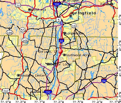
Notable locations in Enfield: Southwood Shopping Parkade (A), Triano Industrial Park (B), Warehouse Point Station (C), Grassmere Golf Course (D), Enfield Square (E), Enfield Shopping Plaza (F), Cybulski Industrial Park (G), Enfield Memorial Industrial Park (H), Osborn Prison Farm (I), Enfield Fire Department District 1 Station 2 (J), Enfield Fire Department District 1 Station 1 (K), Hazardville Fire Department (L), Shaker Pines Fire Department (M), North Thompsonville Fire Department (N), Thompsonville Fire Department District 2 (O), Enfield Town Fire Dispatch Center (P), Thompsonville Town Hall (Q), Saint Patricks Convent (R), Pearl Street Branch Enfield Public Library (S), Old Town Hall Historical Society Building (T). Display/hide their locations on the map
Shopping Centers: Raffia Shopping Center (1), Suburban Enfield Mall (2), Southwood Shopping Parkade Shopping Center (3), Stateline Plaza Shopping Center (4), Suburban Enfield Mall Shopping Center (5), Raffia Shopping Center (6), Enfield Mall (7), Elm Plaza Shopping Center (8), Enfield Shopping Plaza Shopping Center (9). Display/hide their locations on the map
Churches in Enfield include: Saint Andrew Episcopal Church (A), Saint Bernard Roman Catholic Church (B), Saint Martha Roman Catholic Church (C), Saint Marys Episcopal Church (D), Saint Nicholas Greek Orthodox Church (E), Saint Patricks Roman Catholic Church (F), Wesley Methodist Church (G), Calvary Presbyterian Church (H), Enfield American Baptist Church (I). Display/hide their locations on the map
Cemeteries: Saint Bernards Cemetery (1), Saint Patricks Cemetery (2), Enfield Street Cemetery (3), King Street Cemetery (4). Display/hide their locations on the map
Lakes and reservoirs: Stowes Pond (A), Cranberry Pond (B), Freshwater Pond (C), Shaker Pond (D), Powder Mill Ponds (E), Connecticut River Reservoir (F), Green Manor Pool (G), Crescent Lake (H). Display/hide their locations on the map
Streams, rivers, and creeks: Rustic Brook (A), Beemans Brook (B), Boweyns Brook (C), Buckhorn Brook (D), Waterworks Brook (E), Grape Brook (F), Freshwater Brook (G), Terry Brook (H), Jawbuck Brook (I). Display/hide their locations on the map
Parks in Enfield include: Hazardville Historic District (1), Lafayette Park (2), Powder Hollow Park (3), Scantic River State Park (4). Display/hide their locations on the map
Tourist attractions: Enfield Historical Society Inc (Museums; 1294 Enfield Street) (1), Enfield Town - Public Libraries- Pearl Street Branch (Cultural Attractions- Events- & Facilities; 159 Pearl Street) (2), Tilt 144 (Amusement & Theme Parks; Enfield Square) (3). Display/hide their approximate locations on the map
Hotels: Clover Leaf Cafe (161 Enfield Street) (1), Motel 6 (11 Hazard Avenue) (2), Red Roof Inns - Enfield (5 Hazard Avenue) (3), Enfield Sober Housing Thirty Six Pleasant St LLC (36 Pleasant Street) (4), Super 8 Motel (1543 King Street) (5), Radisson Hotel Springfield Enfield (One Bright Meadow Boulevard) (6), Super 8 Enfield Wndsr Lks Arpt (1543 King Street) (7). Display/hide their approximate locations on the map
Courts: Enfield Town - Administrative Departments- Probate Court (820 Enfield Street) (1), Connecticut State - Judicial Branch- Appellate Court- Administrative Serv (111 Phoenix Avenue) (2). Display/hide their approximate locations on the map
Birthplace of: Elisha M. Pease - Politician, Mike Whalen - Football player and coach, James Dixon - Politician.
Drinking water stations with addresses in Enfield and their reported violations in the past:
HAZARDVILLE WATER COMPANY (Population served: 18,544, Groundwater):Past health violations:JEWETT CITY WATER COMPANY (Population served: 6,840, Surface water):Past monitoring violations:
- MCL, Monthly (TCR) - In SEP-2005, Contaminant: Coliform. Follow-up actions: St Public Notif requested (OCT-20-2005), St Violation/Reminder Notice (OCT-20-2005), St Public Notif received (OCT-20-2005), St Compliance achieved (MAR-31-2006)
- Monitoring and Reporting (DBP) - Between JUL-2013 and SEP-2013, Contaminant: Chlorine. Follow-up actions: St Violation/Reminder Notice (FEB-06-2014), St Compliance achieved (FEB-06-2014)
- Monitoring and Reporting (DBP) - Between JAN-2008 and MAR-2008, Contaminant: Chlorine. Follow-up actions: St Violation/Reminder Notice (MAY-20-2008), St Compliance achieved (JUN-09-2008)
- Monitoring and Reporting (DBP) - Between OCT-2007 and DEC-2007, Contaminant: Chlorine. Follow-up actions: St Violation/Reminder Notice (MAR-10-2008), St Compliance achieved (APR-01-2008)
- Monitoring and Reporting (DBP) - Between JUL-2007 and SEP-2007, Contaminant: Chlorine. Follow-up actions: St Compliance achieved (OCT-31-2007), St Public Notif requested (DEC-06-2007), St Violation/Reminder Notice (DEC-06-2007), St Public Notif received (JAN-08-2008)
- Monitoring and Reporting (DBP) - Between JUL-2006 and SEP-2006, Contaminant: Chlorine. Follow-up actions: St Violation/Reminder Notice (NOV-30-2006), St Compliance achieved (DEC-07-2006)
- One minor monitoring violation
Past monitoring violations:SHAKER HEIGHTS WATER COMPANY (Population served: 172, Groundwater):
- Monitoring and Reporting (DBP) - Between JAN-2012 and MAR-2012, Contaminant: Chlorine. Follow-up actions: St Compliance achieved (MAY-09-2012), St Violation/Reminder Notice (JUN-21-2012)
- Monthly Turbidity Exceed (Enhanced SWTR) - In NOV-2009, Contaminant: IESWTR. Follow-up actions: St Violation/Reminder Notice (DEC-16-2009), St Public Notif requested (DEC-16-2009), St Compliance achieved (DEC-31-2009), St Public Notif received (DEC-31-2009), St BCA signed (JAN-07-2010)
- Monthly Turbidity Exceed (Enhanced SWTR) - In OCT-2009, Contaminant: IESWTR. Follow-up actions: St Violation/Reminder Notice (DEC-16-2009), St Public Notif requested (DEC-16-2009), St Compliance achieved (DEC-31-2009), St Public Notif received (DEC-31-2009), St BCA signed (JAN-07-2010)
- Monitoring and Reporting (DBP) - Between OCT-2007 and DEC-2007, Contaminant: Chlorine. Follow-up actions: St Violation/Reminder Notice (MAR-10-2008), St Compliance achieved (MAR-27-2008)
- One minor monitoring violation
Past health violations:JEWETT CITY WATER CO-HILL-N-DALE (Population served: 146, Groundwater):Past monitoring violations:
- MCL, Monthly (TCR) - Between JUL-2006 and SEP-2006, Contaminant: Coliform. Follow-up actions: St Public Notif requested (JUL-31-2006), St Violation/Reminder Notice (JUL-31-2006), St Public Notif received (AUG-14-2006), St Compliance achieved (MAR-31-2007)
- 2 routine major monitoring violations
- 2 minor monitoring violations
Past monitoring violations:
- Monitoring and Reporting (DBP) - Between JAN-2012 and MAR-2012, Contaminant: Chlorine. Follow-up actions: St Public Notif requested (JUN-12-2012), St Violation/Reminder Notice (JUN-12-2012), St Public Notif received (JUL-17-2012)
Drinking water stations with addresses in Enfield that have no violations reported:
- JEWETT CITY WATER CO., S & W SYSTEM (Population served: 320, Primary Water Source Type: Groundwater)
| This town: | 2.4 people |
| Connecticut: | 2.5 people |
| This town: | 65.6% |
| Whole state: | 66.3% |
| This town: | 7.3% |
| Whole state: | 6.6% |
Likely homosexual households (counted as self-reported same-sex unmarried-partner households)
- Lesbian couples: 0.5% of all households
- Gay men: 0.2% of all households
| This town: | 4.0% |
| Whole state: | 7.9% |
| This town: | 1.9% |
| Whole state: | 3.9% |
People in group quarters in Enfield in 2010:
- 3,374 people in state prisons
- 247 people in nursing facilities/skilled-nursing facilities
- 88 people in other noninstitutional facilities
- 53 people in group homes intended for adults
- 10 people in group homes for juveniles (non-correctional)
- 8 people in residential treatment centers for adults
- 3 people in workers' group living quarters and job corps centers
People in group quarters in Enfield in 2000:
- 3,353 people in state prisons
- 332 people in nursing homes
- 32 people in religious group quarters
- 22 people in homes for the mentally retarded
Banks with most branches in Enfield (2011 data):
- Rockville Bank: Big Y Supermarket Br, Enfield Branch, Enfield Street Branch. Info updated 2011/12/05: Bank assets: $1,748.3 mil, Deposits: $1,413.1 mil, headquarters in Vernon Rockville, CT, positive income, Commercial Lending Specialization, 22 total offices, Holding Company: Rockville Financial, Inc.
- Sovereign Bank, National Association: Hazard Avenue Branch at 40 Hazard Avenue, branch established on 1987/08/31; Enfield Branch at 800 Enfield Street, branch established on 1959/05/16. Info updated 2012/01/31: Bank assets: $78,146.9 mil, Deposits: $48,042.9 mil, headquarters in Wilmington, DE, positive income, Commercial Lending Specialization, 718 total offices, Holding Company: Banco Santander, S.A.
- NEW ENGLAND BANK: 268 Hazard Avenue Branch at 268 Hazard Avenue, branch established on 1916/01/01; New England Bank at 855 Enfield Street, branch established on 1999/11/15. Info updated 2009/06/12: Bank assets: $724.5 mil, Deposits: $582.4 mil, local headquarters, positive income, Commercial Lending Specialization, 15 total offices, Holding Company: New England Bancshares, Inc.
- Webster Bank, National Association: Freshwater Boulevard Branch at 50 Freshwater Boulevard, branch established on 1988/03/28; Hazard Avenue Branch at 561 Hazard Avenue Scitico Plaza, branch established on 1961/12/09. Info updated 2008/12/23: Bank assets: $18,674.3 mil, Deposits: $13,861.5 mil, headquarters in Waterbury, CT, positive income, Commercial Lending Specialization, 167 total offices, Holding Company: Webster Financial Corporation
- People's United Bank: Enfield Stop And Shop Branch at 54 Hazard Avenue, branch established on 1996/10/16; Enfield Mall Branch at 25 Hazard Avenue, branch established on 1970/10/17. Info updated 2012/02/16: Bank assets: $27,319.3 mil, Deposits: $20,835.4 mil, headquarters in Bridgeport, CT, positive income, Commercial Lending Specialization, 374 total offices
- First Niagara Bank, National Association: Enfield Branch at 73 Hazard Avenue, Route 190, branch established on 2003/11/10. Info updated 2011/06/09: Bank assets: $32,750.6 mil, Deposits: $19,595.4 mil, headquarters in Buffalo, NY, positive income, Commercial Lending Specialization, 351 total offices, Holding Company: First Niagara Financial Group, Inc.
- Bank of America, National Association: Enfield Branch at 900 Enfield Street, branch established on 1961/01/30. Info updated 2009/11/18: Bank assets: $1,451,969.3 mil, Deposits: $1,077,176.8 mil, headquarters in Charlotte, NC, positive income, 5782 total offices, Holding Company: Bank Of America Corporation
- The MassMutual Trust Company: The Massmutual Trust Company at 100 Bright Meadow Boulevard M327, branch established on 2000/01/12. Info updated 2012/02/24: Bank assets: $67.4 mil, Deposits: $50.5 mil, local headquarters, negative income in the last year, 1 total offices
- Savings Institute Bank and Trust Company: Enfield Branch at 85 Freshwater Boulevard, branch established on 1989/02/27. Info updated 2011/07/21: Bank assets: $939.9 mil, Deposits: $718.1 mil, headquarters in Willimantic, CT, positive income, Commercial Lending Specialization, 21 total offices
For population 15 years and over in Enfield:
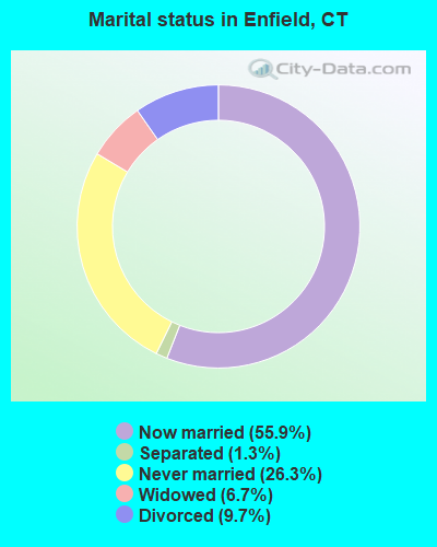
- Never married: 26.3%
- Now married: 55.9%
- Separated: 1.3%
- Widowed: 6.7%
- Divorced: 9.7%
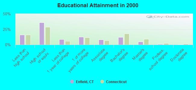
For population 25 years and over in Enfield:
- High school or higher: 83.9%
- Bachelor's degree or higher: 18.2%
- Graduate or professional degree: 6.1%
- Unemployed: 4.1%
- Mean travel time to work (commute): 23.3 minutes
| Here: | 10.2 |
| Connecticut average: | 12.8 |

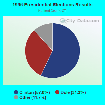
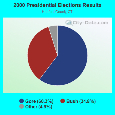
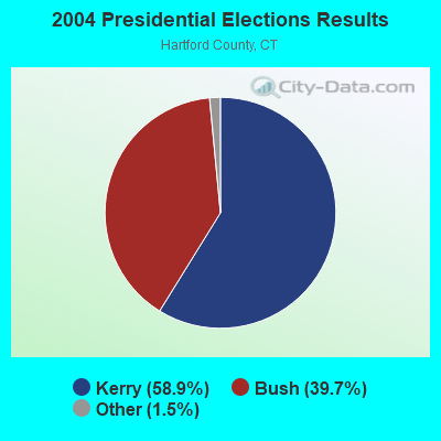
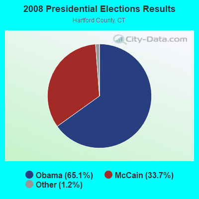
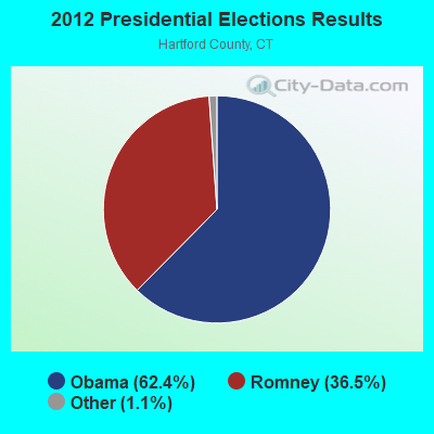
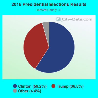
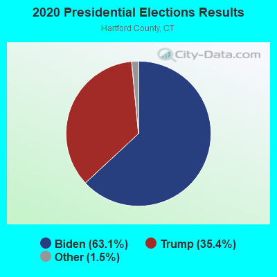
Graphs represent county-level data. Detailed 2008 Election Results
Religion statistics for Enfield, CT (based on Hartford County data)
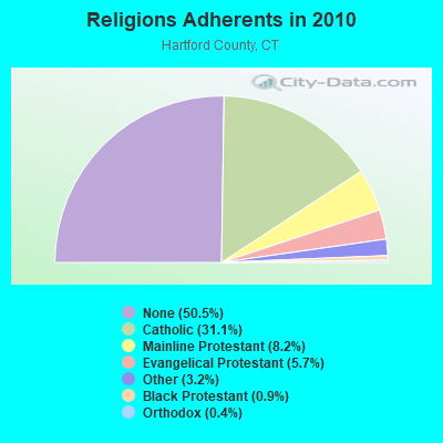
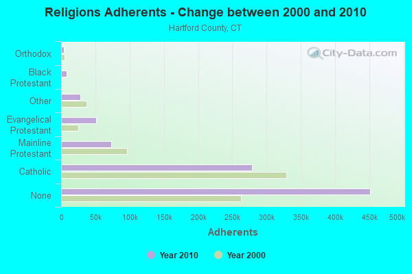
| Religion | Adherents | Congregations |
|---|---|---|
| Catholic | 278,203 | 100 |
| Mainline Protestant | 73,522 | 183 |
| Evangelical Protestant | 50,619 | 214 |
| Other | 28,183 | 94 |
| Black Protestant | 8,446 | 26 |
| Orthodox | 3,665 | 13 |
| None | 451,376 | - |
Food Environment Statistics:
| Hartford County: | 2.46 / 10,000 pop. |
| Connecticut: | 2.21 / 10,000 pop. |
| Here: | 0.06 / 10,000 pop. |
| Connecticut: | 0.07 / 10,000 pop. |
| Hartford County: | 1.05 / 10,000 pop. |
| State: | 1.02 / 10,000 pop. |
| Hartford County: | 2.32 / 10,000 pop. |
| Connecticut: | 2.27 / 10,000 pop. |
| This county: | 8.63 / 10,000 pop. |
| State: | 9.19 / 10,000 pop. |
| Hartford County: | 7.4% |
| Connecticut: | 7.3% |
| Hartford County: | 22.1% |
| Connecticut: | 21.5% |
| Hartford County: | 16.0% |
| Connecticut: | 15.8% |
4.94% of this county's 2021 resident taxpayers lived in other counties in 2020 ($69,891 average adjusted gross income)
| Here: | 4.94% |
| Connecticut average: | 5.79% |
0.04% of residents moved from foreign countries ($102 average AGI)
Hartford County: 0.04% Connecticut average: 0.02%
Top counties from which taxpayers relocated into this county between 2020 and 2021:
| from New Haven County, CT | |
| from Tolland County, CT | |
| from Middlesex County, CT |
5.15% of this county's 2020 resident taxpayers moved to other counties in 2021 ($92,529 average adjusted gross income)
| Here: | 5.15% |
| Connecticut average: | 5.82% |
0.03% of residents moved to foreign countries ($235 average AGI)
Hartford County: 0.03% Connecticut average: 0.02%
Top counties to which taxpayers relocated from this county between 2020 and 2021:
| to Tolland County, CT | |
| to New Haven County, CT | |
| to Middlesex County, CT |
| Businesses in Enfield, CT | ||||
| Name | Count | Name | Count | |
|---|---|---|---|---|
| 7-Eleven | 1 | Macy's | 1 | |
| ALDI | 1 | Marshalls | 1 | |
| AT&T | 1 | MasterBrand Cabinets | 7 | |
| Advance Auto Parts | 1 | McDonald's | 4 | |
| Aeropostale | 1 | Motel 6 | 1 | |
| American Eagle Outfitters | 1 | Motherhood Maternity | 1 | |
| Arby's | 1 | Nike | 2 | |
| AutoZone | 1 | Nissan | 1 | |
| Barnes & Noble | 1 | Office Depot | 1 | |
| Bath & Body Works | 1 | Old Navy | 1 | |
| Bed Bath & Beyond | 1 | Olive Garden | 1 | |
| Blockbuster | 1 | Outback | 1 | |
| Burger King | 1 | Outback Steakhouse | 1 | |
| CVS | 2 | Panera Bread | 1 | |
| Charlotte Russe | 1 | Payless | 1 | |
| Costco | 1 | PetSmart | 1 | |
| Dairy Queen | 1 | Pier 1 Imports | 1 | |
| Decora Cabinetry | 2 | Pizza Hut | 1 | |
| Dennys | 1 | Plato's Closet | 1 | |
| Domino's Pizza | 1 | Quiznos | 1 | |
| DressBarn | 1 | RadioShack | 1 | |
| Dressbarn | 1 | Red Robin | 1 | |
| Dunkin Donuts | 6 | Red Roof Inn | 1 | |
| Express | 1 | Rite Aid | 1 | |
| Famous Footwear | 1 | Ruby Tuesday | 1 | |
| FedEx | 3 | Sears | 2 | |
| Finish Line | 1 | Sprint Nextel | 1 | |
| Firestone Complete Auto Care | 1 | Staples | 1 | |
| Ford | 1 | Starbucks | 1 | |
| GNC | 1 | Stop & Shop | 1 | |
| GameStop | 1 | Subway | 2 | |
| H&R Block | 2 | Super 8 | 1 | |
| Hilton | 1 | T-Mobile | 2 | |
| Holiday Inn | 1 | T.G.I. Driday's | 1 | |
| Home Depot | 1 | Taco Bell | 1 | |
| Honda | 1 | Target | 1 | |
| Hot Topic | 1 | The Room Place | 1 | |
| Hyundai | 1 | Toyota | 1 | |
| Jones New York | 1 | Toys"R"Us | 1 | |
| Justice | 1 | UPS | 7 | |
| KFC | 1 | Verizon Wireless | 1 | |
| Kohl's | 1 | Victoria's Secret | 1 | |
| La-Z-Boy | 1 | Volkswagen | 1 | |
| Lane Bryant | 1 | Walgreens | 2 | |
| Lane Furniture | 1 | Wendy's | 1 | |
| LensCrafters | 1 | |||
Strongest AM radio stations in Enfield:
- WNNZ (640 AM; 50 kW; WESTFIELD, MA; Owner: CLEAR CHANNEL BROADCASTING LICENSES, INC.)
- WTIC (1080 AM; 50 kW; HARTFORD, CT; Owner: INFINITY RADIO OPERATIONS INC.)
- WSPR (1270 AM; 5 kW; SPRINGFIELD, MA; Owner: ANTONIO F. AND HELENA R. GOIS, TENANTS BY THE ENTIRETY)
- WCRN (830 AM; 50 kW; WORCESTER, MA; Owner: CARTER BROADCASTING CORPORATION)
- WHNP (1600 AM; 2 kW; EAST LONGMEADOW, MA; Owner: SAGA COMMUNICATIONS OF NEW ENGLAND, LLC)
- WACE (730 AM; 5 kW; CHICOPEE, MA; Owner: CARTER BROADCASTING CORP.)
- WHYN (560 AM; 5 kW; SPRINGFIELD, MA; Owner: CLEAR CHANNEL BROADCASTING LICENSES, INC.)
- WVNE (760 AM; daytime; 25 kW; LEICESTER, MA; Owner: BLOUNT MASSCOM, INC.)
- WDZK (1550 AM; 5 kW; BLOOMFIELD, CT; Owner: ABC, INC.)
- WALE (990 AM; 50 kW; GREENVILLE, RI; Owner: NORTH AMERICAN BROADCASTING CO., INC.)
- WDRC (1360 AM; 5 kW; HARTFORD, CT; Owner: BUCKLEY BROADCASTING CORPORATION)
- WEEI (850 AM; 50 kW; BOSTON, MA; Owner: ENTERCOM BOSTON LICENSE, LLC)
- WRKO (680 AM; 50 kW; BOSTON, MA; Owner: ENTERCOM BOSTON LICENSE, LLC)
Strongest FM radio stations in Enfield:
- WAQY (102.1 FM; SPRINGFIELD, MA; Owner: SAGA COMMUNICATIONS OF NEW ENGLAND, LLC)
- WPKX (97.9 FM; ENFIELD, CT; Owner: CAPSTAR TX LIMITED PARTNERSHIP)
- WHYN-FM (93.1 FM; SPRINGFIELD, MA; Owner: CLEAR CHANNEL BROADCASTING LICENSES, INC.)
- WRNX (100.9 FM; AMHERST, MA; Owner: WESTERN MASSACHUSETTS RADIO COMPANY)
- WRCH (100.5 FM; NEW BRITAIN, CT; Owner: INFINITY RADIO OPERATIONS INC.)
- WTIC-FM (96.5 FM; HARTFORD, CT; Owner: INFINITY RADIO OPERATIONS INC.)
- WCCC-FM (106.9 FM; HARTFORD, CT; Owner: MARLIN BROADCASTING, LLC)
- WWUH (91.3 FM; WEST HARTFORD, CT; Owner: UNIVERSITY OF HARTFORD)
- WFCR (88.5 FM; AMHERST, MA; Owner: UNIVERSITY OF MASSACHUSETTS)
- WMAS-FM (94.7 FM; SPRINGFIELD, MA; Owner: LAPPIN COMMUNICATIONS, INC.)
- WAMC-FM (90.3 FM; ALBANY, NY; Owner: WAMC)
- WHUS (91.7 FM; STORRS, CT; Owner: THE BD. OF TRUSTEES, THE UNIV. OF CT)
- WAMH (89.3 FM; AMHERST, MA; Owner: TRUSTEES OF AMHERST COLLEGE)
- WWYZ (92.5 FM; WATERBURY, CT; Owner: CAPSTAR TX LIMITED PARTNERSHIP)
- WKSS (95.7 FM; HARTFORD-MERIDEN, CT; Owner: CAPSTAR TX LIMITED PARTNERSHIP)
- WZMX (93.7 FM; HARTFORD, CT; Owner: INFINITY RADIO OPERATIONS INC.)
- WHCN (105.9 FM; HARTFORD, CT; Owner: CAPSTAR TX LIMITED PARTNERSHIP)
- WMRQ (104.1 FM; WATERBURY, CT; Owner: CAPSTAR TX LIMITED PARTNERSHIP)
- WAAF (107.3 FM; WORCESTER, MA; Owner: ENTERCOM BOSTON LICENSE, LLC)
- WPKT (90.5 FM; MERIDEN, CT; Owner: CONNECTICUT PUBLIC BROADCASTING, INC)
TV broadcast stations around Enfield:
- WTIC-TV (Channel 61; HARTFORD, CT; Owner: TRIBUNE TELEVISION COMPANY)
- W11BJ (Channel 11; HARTFORD, CT; Owner: COMMUNICATIONS SITE MANAGEMENT LLC)
- WWLP (Channel 22; SPRINGFIELD, MA; Owner: WWLP BROADCASTING, LLC)
- WUVN (Channel 18; HARTFORD, CT; Owner: ENTRAVISION HOLDINGS, LLC)
- WYDN (Channel 48; WORCESTER, MA; Owner: EDUCATIONAL PUBLIC TV CORPORATION)
- WTXX (Channel 20; WATERBURY, CT; Owner: WTXX INC.)
- WVIT (Channel 30; NEW BRITAIN, CT; Owner: OUTLET BROADCASTING, INC)
- WEDH (Channel 24; HARTFORD, CT; Owner: CONNECTICUT PUBLIC BROADCASTING, INC.)
- WFSB (Channel 3; HARTFORD, CT; Owner: MEREDITH CORPORATION)
- W67DF (Channel 67; SPRINGFIELD, MA; Owner: TRINITY BROADCASTING NETWORK)
- W12CL (Channel 12; GRANBY, CT; Owner: SALVATORE MINNITI)
- WDMR-LP (Channel 65; SPRINGFIELD, MA; Owner: ZGS HARTFORD, INC.)
- WHCT-LP (Channel 38; HARTFORD, CT; Owner: VENTURE TECHNOLOGIES GROUP, LLC)
- WHTX-LP (Channel 10; HARTFORD, CT; Owner: ENTRAVISION HOLDINGS, LLC)
- WRDM-LP (Channel 13; HARTFORD, CT; Owner: ZGS HARTFORD, INC.)
- WHPX (Channel 26; NEW LONDON, CT; Owner: PAXSON HARTFORD LICENSE, INC.)
- WUNI (Channel 27; WORCESTER, MA; Owner: ENTRAVISION HOLDINGS, LLC)
- WMLD-LP (Channel 6; HARTFORD, CT; Owner: HARVARD BROADCASTING, INC.)
- WPXQ (Channel 69; BLOCK ISLAND, RI; Owner: OCEAN STATE TELEVISION, L.L.C.)
- WGBY-TV (Channel 57; SPRINGFIELD, MA; Owner: WGBH EDUCATIONAL FOUNDATION)
- WGGB-TV (Channel 40; SPRINGFIELD, MA; Owner: WGGB LICENSEE, LLC)
- National Bridge Inventory (NBI) Statistics
- 30Number of bridges
- 223ft / 67.9mTotal length
- $3,375,000Total costs
- 1,213,008Total average daily traffic
- 135,162Total average daily truck traffic
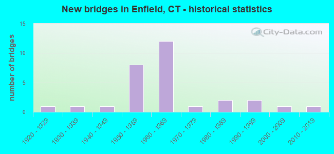
- New bridges - historical statistics
- 11920-1929
- 11930-1939
- 11940-1949
- 81950-1959
- 121960-1969
- 11970-1979
- 21980-1989
- 21990-1999
- 12000-2009
- 12010-2019
FCC Registered Antenna Towers:
48 (See the full list of FCC Registered Antenna Towers in Enfield)FCC Registered Broadcast Land Mobile Towers:
24 (See the full list of FCC Registered Broadcast Land Mobile Towers in Enfield, CT)FCC Registered Microwave Towers:
6- STATION, 180 Moody Rd (Lat: 42.002028 Lon: -72.522861), Overall height: 54.9 m, Call Sign: WNER265,
Assigned Frequencies: 23275.0 MHz, Grant Date: 09/11/2002, Expiration Date: 09/24/2012, Cancellation Date: 11/24/2012, Phone: (413) 787-9722
- ENFIELD STUDIO, 170 Elm Street (Lat: 41.977222 Lon: -72.584167), Type: Tower, Structure height: 30.5 m, Call Sign: WPXB504,
Assigned Frequencies: 946.500 MHz, Grant Date: 02/26/2003, Expiration Date: 04/01/2030, Certifier: Thomas J Vesci, Registrant: Sterling Communications, Inc., 219 Dodd Road, Ringgold, GA 30736-2958, Phone: (706) 965-2355, Fax: (706) 965-3755, Email:
- Enfd - Enfield, Town Farm Road (Lat: 41.965917 Lon: -72.552694), Type: Pole, Structure height: 46.3 m, Overall height: 51.5 m, Call Sign: WQIT209,
Assigned Frequencies: 11035.0 MHz, Grant Date: 05/07/2008, Expiration Date: 05/07/2018, Cancellation Date: 11/07/2009, Certifier: William Chastain, Registrant: Radio Dynamics Corporation, Silver Spring, MD 20914, Phone: (301) 493-5171, Fax: (301) 576-4553, Email:
- CT-HFD0147A, 1654 King Street (Lat: 41.945611 Lon: -72.604944), Type: Pole, Structure height: 47.5 m, Call Sign: WQMQ437,
Assigned Frequencies: 11265.0 MHz, 21875.0 MHz, 11385.0 MHz, 21975.0 MHz, Grant Date: 11/10/2020, Expiration Date: 10/21/2030, Cancellation Date: 09/14/2021, Certifier: Nadja S Sodos-Wallace, Registrant: T-Mobile Usa, Inc., 12920 Se 38th Street, Bellevue, WA 98006, Phone: (425) 383-8402, Fax: (425) 383-4840, Email:
- CT-HFD0006A, Town Farm Road (Lat: 41.965917 Lon: -72.552694), Type: Pole, Structure height: 46.3 m, Overall height: 51.5 m, Call Sign: WQMQ439,
Assigned Frequencies: 10775.0 MHz, 10855.0 MHz, Grant Date: 11/10/2020, Expiration Date: 10/21/2030, Cancellation Date: 05/11/2023, Certifier: Nadja S Sodos-Wallace, Registrant: T-Mobile Usa, Inc., 12920 Se 38th Street, Bellevue, WA 98006, Phone: (425) 383-8401, Email:
- CT-HFD0007B, 4 Oliver Road (Lat: 41.960056 Lon: -72.592333), Type: Pole, Structure height: 45.7 m, Call Sign: WQMQ462,
Assigned Frequencies: 11305.0 MHz, 23075.0 MHz, 11425.0 MHz, 23175.0 MHz, Grant Date: 11/10/2020, Expiration Date: 10/21/2030, Cancellation Date: 09/14/2021, Certifier: Nadja S Sodos-Wallace, Registrant: T-Mobile Usa, Inc., 12920 Se 38th Street, Bellevue, WA 98006, Phone: (425) 383-8402, Fax: (425) 383-4840, Email:
FCC Registered Paging Towers:
1- Town Farm Rd. (Lat: 41.964806 Lon: -72.552306), Type: Tower, Structure height: 45.7 m, Overall height: 50.9 m, Call Sign: KNKM752,
Assigned Frequencies: 931.187 MHz, Grant Date: 04/19/1999, Expiration Date: 04/01/2009, Cancellation Date: 05/23/2009, Certifier: Shawn E Endsley, Registrant: Usa Mobility Wireless, Inc., 300 Technology Drive #400, Plano, TX 75074, Phone: (972) 801-1626, Fax: (972) 801-1699, Email:
FCC Registered Amateur Radio Licenses:
222 (See the full list of FCC Registered Amateur Radio Licenses in Enfield)FAA Registered Aircraft:
17 (See the full list of FAA Registered Aircraft in Enfield)2002 - 2018 National Fire Incident Reporting System (NFIRS) incidents
- Fire incident types reported to NFIRS in Enfield, CT
- 1,93653.0%Structure Fires
- 97126.6%Outside Fires
- 48513.3%Mobile Property/Vehicle Fires
- 2617.1%Other
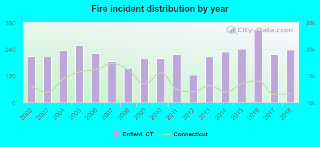 Based on the data from the years 2002 - 2018 the average number of fire incidents per year is 215. The highest number of reported fires - 326 took place in 2016, and the least - 123 in 2012. The data has an increasing trend.
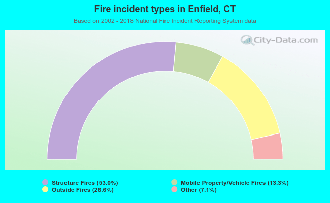 When looking into fire subcategories, the most reports belonged to: Structure Fires (53.0%), and Outside Fires (26.6%).
Fire-safe hotels and motels in Enfield, Connecticut:
- Holiday Inn, 1 Bright Meadow Blvd, Enfield, Connecticut 06082 , Phone: (860) 741-2211, Fax: (860) 741-2210
- Hampton Inn Enfield, 20 Phoenix Ave, Enfield, Connecticut 06082 , Phone: (860) 741-3111, Fax: (860) 741-3444
| Most common first names in Enfield, CT among deceased individuals | ||
| Name | Count | Lived (average) |
|---|---|---|
| Mary | 394 | 81.2 years |
| John | 379 | 73.8 years |
| Joseph | 271 | 74.3 years |
| Robert | 191 | 70.7 years |
| William | 190 | 72.1 years |
| Helen | 162 | 79.2 years |
| Charles | 162 | 75.1 years |
| Edward | 158 | 74.8 years |
| James | 157 | 70.1 years |
| Anna | 148 | 83.0 years |
| Most common last names in Enfield, CT among deceased individuals | ||
| Last name | Count | Lived (average) |
|---|---|---|
| Smith | 62 | 77.2 years |
| White | 38 | 80.8 years |
| Johnson | 36 | 74.6 years |
| Sullivan | 33 | 76.7 years |
| Landry | 30 | 74.7 years |
| Martin | 29 | 74.5 years |
| Brown | 28 | 78.4 years |
| Miller | 25 | 75.3 years |
| King | 25 | 80.8 years |
| Sarno | 24 | 76.3 years |
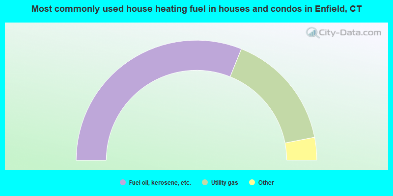
- 62.2%Fuel oil, kerosene, etc.
- 31.7%Utility gas
- 3.2%Electricity
- 1.4%Bottled, tank, or LP gas
- 0.8%Wood
- 0.4%Other fuel
- 0.2%Coal or coke
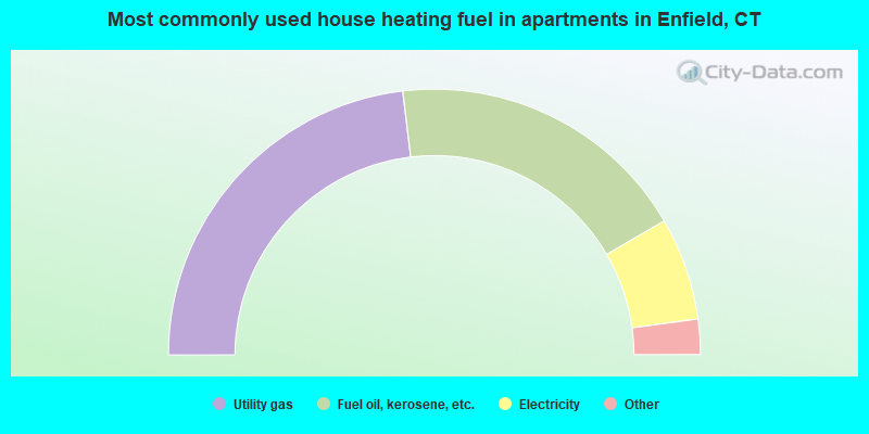
- 46.2%Utility gas
- 37.0%Fuel oil, kerosene, etc.
- 12.5%Electricity
- 3.1%Bottled, tank, or LP gas
- 0.6%No fuel used
- 0.5%Other fuel
- 0.1%Wood
Enfield compared to Connecticut state average:
- Unemployed percentage significantly below state average.
- Hispanic race population percentage below state average.
- Foreign-born population percentage significantly below state average.
- Length of stay since moving in significantly above state average.
- Number of rooms per house significantly below state average.
- House age significantly below state average.
- Institutionalized population percentage significantly above state average.
- Percentage of population with a bachelor's degree or higher below state average.
Enfield on our top lists:
- #1 on the list of "Top 101 cities with largest percentage of females in industries: paper and paper products merchant wholesalers (population 5,000+)"
- #8 on the list of "Top 101 cities with largest percentage of males in industries: paper and paper products merchant wholesalers (population 5,000+)"
- #36 on the list of "Top 101 cities with largest percentage of males in occupations: occupational and physical therapist assistants and aides (population 5,000+)"
- #46 on the list of "Top 101 cities with largest percentage of males in occupations: customer service representatives (population 5,000+)"
- #79 on the list of "Top 101 cities with largest percentage of females in industries: clothing and accessories, including shoe, stores (population 5,000+)"
- #87 on the list of "Top 101 cities with largest percentage of males in industries: transportation equipment (population 5,000+)"
- #98 on the list of "Top 101 cities with largest percentage of females in industries: farm supplies merchant wholesalers (population 5,000+)"
- #99 on the list of "Top 101 cities with largest percentage of females in industries: music stores (population 5,000+)"
- #2 on the list of "Top 101 counties with highest percentage of residents voting for Obama (Democrat) in the 2012 Presidential Election"
- #17 on the list of "Top 101 counties with the most Catholic congregations"
- #19 on the list of "Top 101 counties with the lowest Particulate Matter (PM10) Annual air pollution readings in 2012 (µg/m3)"
- #24 on the list of "Top 101 counties with the highest percentage of residents that visited a dentist within the past year"
- #29 on the list of "Top 101 counties with the most Mainline Protestant congregations"

|
|
Total of 477 patent applications in 2008-2024.