Bridge Statistics for Enfield, Connecticut (CT)
Condition, Traffic, Stress, Structural Evaluation, Project Costs
- National Bridge Inventory (NBI) Statistics
- 30Number of bridges
- 223ft / 67.9mTotal length
- $3,375,000Total costs
- 1,213,008Total average daily traffic
- 135,162Total average daily truck traffic
- National Bridge Inventory (NBI) Registered Bridges for Enfield
- No street view available for this location
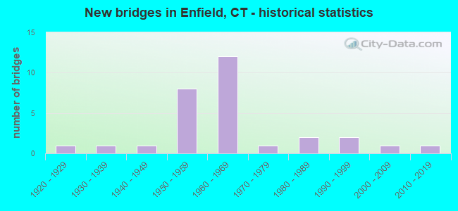
- New bridges - historical statistics
- 11920-1929
- 11930-1939
- 11940-1949
- 81950-1959
- 121960-1969
- 11970-1979
- 21980-1989
- 21990-1999
- 12000-2009
- 12010-2019

- Reconstructed bridges - Historical Statistics
- 11970-1979
- 61980-1989
- 21990-1999
- 12000-2009


- Bridge Condition - Deck
- 46.7%Good
- 26.7%Satisfactory
- 20.0%Fair
- 6.7%Poor

- Bridge Condition - Superstructure
- 5.6%Very good
- 22.2%Good
- 38.9%Satisfactory
- 27.8%Fair
- 5.6%Poor

- Bridge Condition - Substructure
- 5.9%Very good
- 41.2%Good
- 52.9%Satisfactory

- Bridge Condition - Channel
- 27.3%Good
- 54.5%Satisfactory
- 18.2%Fair

- Bridge Condition - Culverts
- 66.7%Good
- 33.3%Satisfactory
Find on map >> Show street view
Structure Number: 443, Location: 1.2 MI N OF E WINDSOR TL (Lat: 41.953133, Lng: -72.601083), Route carried "on" structure: US 5, Year Built: 1959, Year Reconstructed: 1992, Status: Open, Structure Length: 7.70m (25.26ft), Average Daily Traffic: 13,800 (year 2016), Truck Traffic: 6%, Average Future Daily Traffic: 20,505 (year 2036), Design Load: HS 20, Features Intersected: INTERSTATE-91
Minimum Vertical Clearance: 30+ m (98+ ft), Kilometerpoint: 79.325, Lanes on structure: 2, Lanes under structure: 6, Base Highway Network: Yes, Owner: State Highway Agency, Approaching Roadway Width: 13.4m (44.0ft), Skew: 4 degrees, Material/Design: Steel, Design/Construction: Stringer/Multi-beam, Number Of Spans In Main Unit: 4, Length of Maximum Span: 25.3m (83.0ft), Curb or Sidewalk Widths: Left: 1.7m (5.6ft), Right: 1.7m (5.6ft), Curb-To-Curb Width: 13.4m (44.0ft), Out-to-Out Width: 17.5m (57.4ft)
Condition: Deck: Good, Superstructure: Fair, Substructure: Satisfactory, Operating Rating: 63.4 metric tons, Method Used To Determine Operating Rating: Load Factor (LF), Inventory Rating: 38.0 metric tons, Method Used To Determine Inventory Rating: Load Factor (LF), Structural Evaluation: Somewhat better than minimum adequacy, Deck Geometry: Equal to present minimum criteria, Underclear: High priority of corrective action, Approach Roadway Alignment: Equal to present desirable criteria, Designated Inspection Frequency: Every 24 months, Inspection Date: June 2021, Deck Structure Type: Concrete Cast-file-Place, Wearing Surface/Protective System: Wearing Surface: Bituminous, Membrane: Preformed Fabric, Deck Protection: Epoxy Coated Reinforcing
Find on map >> Show street view
Structure Number: 444, Location: 500 FT SOUTH OF RTE 220 (Lat: 41.996672, Lng: -72.594461), Route carried "on" structure: US 5, Year Built: 1934, Status: Open, Structure Length: 1.07m (3.51ft), Average Daily Traffic: 12,700 (year 2016), Truck Traffic: 4%, Average Future Daily Traffic: 18,871 (year 2036), Design Load: H 20, Features Intersected: FRESHWATER BROOK
Minimum Vertical Clearance: 30+ m (98+ ft), Kilometerpoint: 84.442, Lanes on structure: 4, Base Highway Network: Yes, Owner: State Highway Agency, Approaching Roadway Width: 14.9m (48.9ft), Material/Design: Concrete, Design/Construction: Tee Beam, Number Of Spans In Main Unit: 1, Length of Maximum Span: 9.8m (32.2ft), Curb-To-Curb Width: 15.2m (49.9ft), Out-to-Out Width: 16.8m (55.1ft)
Condition: Deck: Fair, Superstructure: Fair, Substructure: Satisfactory, Channel: Satisfactory, Operating Rating: 30.8 metric tons, Method Used To Determine Operating Rating: Load and Resistance Factor Rating (LRFR) rating reported by rating factor(RF) method using HL-93 loadings, Inventory Rating: 23.7 metric tons, Method Used To Determine Inventory Rating: Load and Resistance Factor Rating (LRFR) rating reported by rating factor(RF) method using HL-93 loadings, Structural Evaluation: Somewhat better than minimum adequacy, Deck Geometry: High priority of corrective action, Waterway Adequacy: Equal to present minimum criteria, Approach Roadway Alignment: Equal to present desirable criteria, Designated Inspection Frequency: Every 24 months, Inspection Date: May 2021, Deck Structure Type: Concrete Cast-file-Place, Wearing Surface/Protective System: Wearing Surface: Bituminous, Membrane: Built-up
Find on map >> Show street view
Structure Number: 1274, Location: 0.25 MILES W OF ROUTE 5 (Lat: 41.938461, Lng: -72.607131), Route carried "on" structure: City street , Year Built: 1959, Year Reconstructed: 1995, Status: Open, Structure Length: 6.49m (21.29ft), Average Daily Traffic: 1,900 (year 2021), Truck Traffic: 4%, Average Future Daily Traffic: 2,823 (year 2041), Design Load: HS 20, Features Intersected: INTERSTATE-91, Facility Carried by Structure: PLEASANT ROAD
Minimum Vertical Clearance: 30+ m (98+ ft), Kilometerpoint: 0.274, Lanes on structure: 2, Lanes under structure: 6, Owner: State Highway Agency, Approaching Roadway Width: 9.1m (29.9ft), Skew: 2 degrees, Material/Design: Steel continuous, Design/Construction: Stringer/Multi-beam, Number Of Spans In Main Unit: 4, Length of Maximum Span: 20.4m (66.9ft), Curb or Sidewalk Widths: Left: 1.5m (4.9ft), Right: 1.5m (4.9ft), Curb-To-Curb Width: 9.1m (29.9ft), Out-to-Out Width: 13.0m (42.7ft)
Condition: Deck: Satisfactory, Superstructure: Poor, Substructure: Satisfactory, Operating Rating: 40.5 metric tons, Method Used To Determine Operating Rating: Load and Resistance Factor Rating (LRFR) rating reported by rating factor(RF) method using HL-93 loadings, Inventory Rating: 31.1 metric tons, Method Used To Determine Inventory Rating: Load and Resistance Factor Rating (LRFR) rating reported by rating factor(RF) method using HL-93 loadings, Structural Evaluation: Meets minimum limits, Deck Geometry: Somewhat better than minimum adequacy, Underclear: High priority of corrective action, Approach Roadway Alignment: Equal to present desirable criteria, Designated Inspection Frequency: Every 24 months, Inspection Date: July 2021, Deck Structure Type: Concrete Cast-file-Place, Wearing Surface/Protective System: Wearing Surface: Bituminous, Membrane: Built-up, Deck Protection: Epoxy Coated Reinforcing
Find on map >> Show street view
Structure Number: 1282, Location: 0.3 MILE EAST OF U.S. 5 (Lat: 41.990233, Lng: -72.587703), Route carried "on" structure: State highway 190, Year Built: 1960, Year Reconstructed: 1990, Status: Open, Structure Length: 5.79m (19.00ft), Average Daily Traffic: 30,400 (year 2015), Truck Traffic: 6%, Average Future Daily Traffic: 45,171 (year 2035), Design Load: HS 20, Features Intersected: INTERSTATE-91
Minimum Vertical Clearance: 30+ m (98+ ft), Kilometerpoint: 5.826, Lanes on structure: 6, Lanes under structure: 8, Base Highway Network: Yes, Owner: State Highway Agency, Approaching Roadway Width: 28.3m (92.8ft), Skew: 30 degrees, Material/Design: Steel, Design/Construction: Stringer/Multi-beam, Number Of Spans In Main Unit: 2, Length of Maximum Span: 28.0m (91.9ft), Curb or Sidewalk Widths: Left: 1.5m (4.9ft), Right: 1.5m (4.9ft), Curb-To-Curb Width: 28.3m (92.8ft), Out-to-Out Width: 33.1m (108.6ft)
Condition: Deck: Good, Superstructure: Fair, Substructure: Satisfactory, Operating Rating: 52.5 metric tons, Method Used To Determine Operating Rating: Load and Resistance Factor Rating (LRFR) rating reported by rating factor(RF) method using HL-93 loadings, Inventory Rating: 40.5 metric tons, Method Used To Determine Inventory Rating: Load and Resistance Factor Rating (LRFR) rating reported by rating factor(RF) method using HL-93 loadings, Structural Evaluation: Somewhat better than minimum adequacy, Deck Geometry: Superior to present desirable criteria, Underclear: High priority of corrective action, Approach Roadway Alignment: Equal to present desirable criteria, Designated Inspection Frequency: Every 24 months, Inspection Date: April 2020, Deck Structure Type: Concrete Cast-file-Place, Wearing Surface/Protective System: Wearing Surface: Bituminous, Membrane: Built-up, Deck Protection: Epoxy Coated Reinforcing
Find on map >> Show street view
Structure Number: 1287, Location: .25 MI WEST OF US 5 (Lat: 42.023789, Lng: -72.589447), Route carried "on" structure: City street , Year Built: 1959, Status: Open, Structure Length: 6.24m (20.47ft), Average Daily Traffic: 435 (year 2020), Truck Traffic: 2%, Average Future Daily Traffic: 646 (year 2040), Design Load: HS 20, Features Intersected: INTERSTATE-91, Facility Carried by Structure: SWORD AVENUE
Minimum Vertical Clearance: 30+ m (98+ ft), Kilometerpoint: 0.322, Lanes on structure: 2, Lanes under structure: 7, Owner: State Highway Agency, Approaching Roadway Width: 9.1m (29.9ft), Skew: 2 degrees, Material/Design: Steel, Design/Construction: Stringer/Multi-beam, Number Of Spans In Main Unit: 4, Length of Maximum Span: 24.4m (80.1ft), Curb or Sidewalk Widths: Left: 1.5m (4.9ft), Right: 1.5m (4.9ft), Curb-To-Curb Width: 9.1m (29.9ft), Out-to-Out Width: 13.0m (42.7ft)
Condition: Deck: Fair, Superstructure: Fair, Substructure: Satisfactory, Operating Rating: 37.9 metric tons, Method Used To Determine Operating Rating: Load and Resistance Factor Rating (LRFR) rating reported by rating factor(RF) method using HL-93 loadings, Inventory Rating: 29.2 metric tons, Method Used To Determine Inventory Rating: Load and Resistance Factor Rating (LRFR) rating reported by rating factor(RF) method using HL-93 loadings, Structural Evaluation: Somewhat better than minimum adequacy, Deck Geometry: Equal to present minimum criteria, Underclear: High priority of corrective action, Approach Roadway Alignment: Equal to present desirable criteria, Designated Inspection Frequency: Every 24 months, Inspection Date: Febuary 2020, Deck Structure Type: Concrete Cast-file-Place, Wearing Surface/Protective System: Wearing Surface: Bituminous
Find on map >> Show street view
Structure Number: 1527, Location: 0.1 MI SOUTH OF ROUTE 190 (Lat: 41.982794, Lng: -72.516000), Route carried "on" structure: State highway 191, Year Built: 1949, Year Reconstructed: 1987, Status: Open, Structure Length: 2.28m (7.48ft), Average Daily Traffic: 6,400 (year 2016), Truck Traffic: 3%, Average Future Daily Traffic: 9,510 (year 2036), Design Load: HS 20, Features Intersected: SCANTIC RIVER
Minimum Vertical Clearance: 30+ m (98+ ft), Kilometerpoint: 14.758, Lanes on structure: 2, Owner: State Highway Agency, Approaching Roadway Width: 10.1m (33.1ft), Material/Design: Steel, Design/Construction: Stringer/Multi-beam, Number Of Spans In Main Unit: 1, Length of Maximum Span: 21.7m (71.2ft), Curb-To-Curb Width: 10.1m (33.1ft), Out-to-Out Width: 11.8m (38.7ft)
Condition: Deck: Fair, Superstructure: Satisfactory, Substructure: Satisfactory, Channel: Satisfactory, Operating Rating: 60.7 metric tons, Method Used To Determine Operating Rating: Load Factor (LF), Inventory Rating: 36.5 metric tons, Method Used To Determine Inventory Rating: Load Factor (LF), Structural Evaluation: Equal to present minimum criteria, Deck Geometry: Meets minimum limits, Waterway Adequacy: Equal to present desirable criteria, Approach Roadway Alignment: Equal to present desirable criteria, Designated Inspection Frequency: Every 24 months, Underwater Inspection Frequency: Every 24 months, Inspection Date: May 2020, Underwater Inspection Date: April 2020, Deck Structure Type: Concrete Cast-file-Place, Wearing Surface/Protective System: Wearing Surface: Bituminous, Membrane: Built-up
Find on map >> Show street view
Structure Number: 336, Location: 0.5 MILE WEST OF I-91 (Lat: 41.990394, Lng: -72.597742), Route carried "on" structure: City street , Year Built: 1966, Status: Open, Structure Length: 5.73m (18.80ft), Average Daily Traffic: 3,780 (year 2020), Truck Traffic: 4%, Average Future Daily Traffic: 5,617 (year 2040), Design Load: HS 20, Features Intersected: ROUTE 190, Facility Carried by Structure: PEARL STREET
Minimum Vertical Clearance: 30+ m (98+ ft), Kilometerpoint: 17.735, Lanes on structure: 2, Lanes under structure: 2, Owner: State Highway Agency, Approaching Roadway Width: 12.2m (40.0ft), Material/Design: Prestressed concrete, Design/Construction: Stringer/Multi-beam, Number Of Spans In Main Unit: 2, Length of Maximum Span: 27.6m (90.6ft), Curb or Sidewalk Widths: Left: 1.7m (5.6ft), Right: 1.7m (5.6ft), Curb-To-Curb Width: 12.2m (40.0ft), Out-to-Out Width: 16.4m (53.8ft)
Condition: Deck: Satisfactory, Superstructure: Fair, Substructure: Satisfactory, Operating Rating: 45.4 metric tons, Method Used To Determine Operating Rating: Load and Resistance Factor Rating (LRFR) rating reported by rating factor(RF) method using HL-93 loadings, Inventory Rating: 33.7 metric tons, Method Used To Determine Inventory Rating: Load and Resistance Factor Rating (LRFR) rating reported by rating factor(RF) method using HL-93 loadings, Structural Evaluation: Somewhat better than minimum adequacy, Deck Geometry: Equal to present minimum criteria, Underclear: Better than present minimum criteria, Approach Roadway Alignment: Equal to present desirable criteria, Designated Inspection Frequency: Every 24 months, Inspection Date: March 2020, Deck Structure Type: Concrete Cast-file-Place, Wearing Surface/Protective System: Wearing Surface: Bituminous, Membrane: Built-up
Find on map >> Show street view
Structure Number: 3361, Location: 2.7 MI N OF I-91 (Lat: 41.990447, Lng: -72.593808), Route carried "on" structure: US 5, Year Built: 1966, Status: Open, Structure Length: 7.28m (23.88ft), Average Daily Traffic: 11,000 (year 2016), Truck Traffic: 6%, Average Future Daily Traffic: 16,345 (year 2036), Design Load: HS 20, Features Intersected: ROUTE 190
Minimum Vertical Clearance: 30+ m (98+ ft), Kilometerpoint: 83.718, Lanes on structure: 3, Lanes under structure: 4, Base Highway Network: Yes, Owner: State Highway Agency, Approaching Roadway Width: 13.7m (44.9ft), Material/Design: Steel continuous, Design/Construction: Stringer/Multi-beam, Number Of Spans In Main Unit: 2, Length of Maximum Span: 38.4m (126.0ft), Curb or Sidewalk Widths: Left: 1.7m (5.6ft), Right: 0.0m, Curb-To-Curb Width: 13.7m (44.9ft), Out-to-Out Width: 16.4m (53.8ft)
Condition: Deck: Satisfactory, Superstructure: Satisfactory, Substructure: Good, Operating Rating: 43.7 metric tons, Method Used To Determine Operating Rating: Load and Resistance Factor Rating (LRFR) rating reported by rating factor(RF) method using HL-93 loadings, Inventory Rating: 33.4 metric tons, Method Used To Determine Inventory Rating: Load and Resistance Factor Rating (LRFR) rating reported by rating factor(RF) method using HL-93 loadings, Structural Evaluation: Equal to present minimum criteria, Deck Geometry: Somewhat better than minimum adequacy, Underclear: Superior to present desirable criteria, Approach Roadway Alignment: Equal to present desirable criteria, Designated Inspection Frequency: Every 24 months, Inspection Date: June 2020, Deck Structure Type: Concrete Cast-file-Place, Wearing Surface/Protective System: Wearing Surface: Bituminous, Membrane: Built-up
Find on map >> Show street view
Structure Number: 3944, Location: 1.5 MILES WEST OF RTE 191 (Lat: 41.954944, Lng: -72.554544), Route carried "on" structure: City street , Year Built: 1968, Year Reconstructed: 2011, Status: Open, Structure Length: 2.71m (8.89ft), Average Daily Traffic: 8,950 (year 2020), Truck Traffic: 4%, Average Future Daily Traffic: 13,299 (year 2040), Design Load: HS 20, Features Intersected: SCANTIC RIVER, Facility Carried by Structure: TOWN FARM ROAD
Minimum Vertical Clearance: 30+ m (98+ ft), Kilometerpoint: 0.016, Lanes on structure: 2, Owner: Town or Township Highway Agency, Approaching Roadway Width: 9.1m (29.9ft), Skew: 1 degrees, Material/Design: Prestressed concrete, Design/Construction: Stringer/Multi-beam, Number Of Spans In Main Unit: 1, Length of Maximum Span: 25.9m (85.0ft), Curb or Sidewalk Widths: Left: 4.6m (15.1ft), Right: 0.0m, Curb-To-Curb Width: 9.1m (29.9ft), Out-to-Out Width: 14.7m (48.2ft)
Condition: Deck: Good, Superstructure: Satisfactory, Substructure: Good, Channel: Satisfactory, Operating Rating: 42.6 metric tons, Method Used To Determine Operating Rating: Field evaluation and documented engineering judgment, Inventory Rating: 32.7 metric tons, Method Used To Determine Inventory Rating: Field evaluation and documented engineering judgment, Structural Evaluation: Equal to present minimum criteria, Deck Geometry: High priority of corrective action, Waterway Adequacy: Equal to present desirable criteria, Approach Roadway Alignment: Equal to present desirable criteria, Designated Inspection Frequency: Every 24 months, Inspection Date: May 2020, Deck Structure Type: Concrete Cast-file-Place, Wearing Surface/Protective System: Wearing Surface: Bituminous, Membrane: Preformed Fabric
Find on map >> Show street view
Structure Number: 3952, Location: 0.5 MILE WEST OF ROUTE 5 (Lat: 41.998356, Lng: -72.600358), Route carried "on" structure: City street , Year Built: 1999, Status: Open, Structure Length: 0.85m (2.79ft), Average Daily Traffic: 4,600 (year 2016), Truck Traffic: 4%, Average Future Daily Traffic: 6,835 (year 2036), Features Intersected: FRESHWATER BROOK, Facility Carried by Structure: NORTH MAIN STREET
Minimum Vertical Clearance: 30+ m (98+ ft), Kilometerpoint: 1.143, Lanes on structure: 2, Owner: Town or Township Highway Agency, Approaching Roadway Width: 13.4m (44.0ft), Skew: 2 degrees, Material/Design: Concrete, Design/Construction: Frame, Number Of Spans In Main Unit: 1, Length of Maximum Span: 8.5m (27.9ft), Curb or Sidewalk Widths: Left: 3.4m (11.2ft), Right: 2.0m (6.6ft), Curb-To-Curb Width: 13.4m (44.0ft), Out-to-Out Width: 41.5m (136.2ft)
Condition: Superstructure: Good, Substructure: Good, Channel: Good, Operating Rating: 42.6 metric tons, Method Used To Determine Operating Rating: Field evaluation and documented engineering judgment, Inventory Rating: 32.7 metric tons, Method Used To Determine Inventory Rating: Field evaluation and documented engineering judgment, Structural Evaluation: Better than present minimum criteria, Deck Geometry: Better than present minimum criteria, Waterway Adequacy: Equal to present desirable criteria, Approach Roadway Alignment: Equal to present desirable criteria, Designated Inspection Frequency: Every 24 months, Inspection Date: May 2020, Deck Structure Type: Other, Wearing Surface/Protective System: Wearing Surface: Bituminous, Membrane: Built-up, Deck Protection: Epoxy Coated Reinforcing
Find on map >> Show street view
Structure Number: 3972, Location: 1750 FT SOUTH OF RTE 190 (Lat: 41.981858, Lng: -72.539925), Route carried "on" structure: City street , Year Built: 2010, Status: Open, Structure Length: 2.62m (8.60ft), Average Daily Traffic: 3,199 (year 2020), Truck Traffic: 4%, Average Future Daily Traffic: 4,753 (year 2040), Design Load: HL 93, Features Intersected: SCANTIC RIVER, Facility Carried by Structure: SOUTH MAPLE STREET
Minimum Vertical Clearance: 30+ m (98+ ft), Kilometerpoint: 0.000, Lanes on structure: 2, Owner: Town or Township Highway Agency, Approaching Roadway Width: 9.1m (29.9ft), Material/Design: Prestressed concrete, Design/Construction: Box Beam or Girders - Multiple, Number Of Spans In Main Unit: 1, Length of Maximum Span: 25.6m (84.0ft), Curb or Sidewalk Widths: Left: 2.3m (7.5ft), Right: 2.3m (7.5ft), Curb-To-Curb Width: 9.2m (30.2ft), Out-to-Out Width: 13.8m (45.3ft)
Condition: Deck: Good, Superstructure: Very good, Substructure: Very good, Channel: Satisfactory, Operating Rating: 67.1 metric tons, Method Used To Determine Operating Rating: Load and Resistance Factor Rating (LRFR) rating reported by rating factor(RF) method using HL-93 loadings, Inventory Rating: 51.5 metric tons, Method Used To Determine Inventory Rating: Load and Resistance Factor Rating (LRFR) rating reported by rating factor(RF) method using HL-93 loadings, Structural Evaluation: Equal to present desirable criteria, Deck Geometry: Meets minimum limits, Waterway Adequacy: Equal to present desirable criteria, Approach Roadway Alignment: Better than present minimum criteria, Designated Inspection Frequency: Every 24 months, Inspection Date: May 2020, Deck Structure Type: Concrete Cast-file-Place, Wearing Surface/Protective System: Wearing Surface: Latex Concrete
Find on map >> Show street view
Structure Number: 4506, Location: 50 FT N OF ASNUNTUCK ST (Lat: 41.998392, Lng: -72.604519), Route carried "on" structure: City street , Year Built: 1920, Year Reconstructed: 1970, Status: Open, Structure Length: 1.16m (3.81ft), Average Daily Traffic: 1,057 (year 2020), Truck Traffic: 2%, Average Future Daily Traffic: 1,571 (year 2040), Features Intersected: FRESHWATER BROOK, Facility Carried by Structure: SOUTH RIVER STREET
Minimum Vertical Clearance: 30+ m (98+ ft), Kilometerpoint: 0.531, Lanes on structure: 2, Owner: Town or Township Highway Agency, Approaching Roadway Width: 4.6m (15.1ft), Material/Design: Steel, Design/Construction: Stringer/Multi-beam, Number Of Spans In Main Unit: 1, Length of Maximum Span: 9.8m (32.2ft), Curb or Sidewalk Widths: Left: 0.3m (1.0ft), Right: 0.3m (1.0ft), Curb-To-Curb Width: 6.7m (22.0ft), Out-to-Out Width: 7.3m (24.0ft)
Condition: Deck: Poor, Superstructure: Satisfactory, Substructure: Satisfactory, Channel: Fair, Operating Rating: 94.5 metric tons, Method Used To Determine Operating Rating: Load Factor (LF), Inventory Rating: 56.7 metric tons, Method Used To Determine Inventory Rating: Load Factor (LF), Structural Evaluation: Equal to present minimum criteria, Deck Geometry: High priority of corrective action, Waterway Adequacy: Equal to present desirable criteria, Approach Roadway Alignment: Equal to present desirable criteria, Designated Inspection Frequency: Every 24 months, Inspection Date: May 2020, Total Project Cost: $3,375,000 ( Estimate for 2016), Deck Structure Type: Concrete Cast-file-Place, Wearing Surface/Protective System: Wearing Surface: Monolithic Concrete
Find on map >> Show street view
Structure Number: 5629, Location: 0.8 MILE NORTH OF EXIT 46 (Lat: 41.963608, Lng: -72.590511), Route carried "on" structure: Interstate 91, Year Built: 1960, Year Reconstructed: 1987, Status: Open, Structure Length: 3.14m (10.30ft), Average Daily Traffic: 99,000 (year 2018), Truck Traffic: 9%, Average Future Daily Traffic: 147,104 (year 2038), Design Load: HS 20, Features Intersected: OLIVER ROAD
Minimum Vertical Clearance: 30+ m (98+ ft), Kilometerpoint: 86.422, Lanes on structure: 6, Lanes under structure: 2, Base Highway Network: Yes, Owner: State Highway Agency, Approaching Roadway Width: 32.9m (107.9ft), Skew: 30 degrees, Material/Design: Steel continuous, Design/Construction: Stringer/Multi-beam, Number Of Spans In Main Unit: 3, Length of Maximum Span: 13.3m (43.6ft), Curb-To-Curb Width: 32.9m (107.9ft), Out-to-Out Width: 35.6m (116.8ft)
Condition: Deck: Good, Superstructure: Satisfactory, Substructure: Good, Operating Rating: 77.8 metric tons, Method Used To Determine Operating Rating: Load and Resistance Factor Rating (LRFR) rating reported by rating factor(RF) method using HL-93 loadings, Inventory Rating: 59.9 metric tons, Method Used To Determine Inventory Rating: Load and Resistance Factor Rating (LRFR) rating reported by rating factor(RF) method using HL-93 loadings, Structural Evaluation: Equal to present minimum criteria, Deck Geometry: Superior to present desirable criteria, Underclear: Meets minimum limits, Approach Roadway Alignment: Equal to present desirable criteria, Designated Inspection Frequency: Every 24 months, Inspection Date: April 2020, Deck Structure Type: Concrete Cast-file-Place, Wearing Surface/Protective System: Wearing Surface: Bituminous, Membrane: Preformed Fabric, Deck Protection: Epoxy Coated Reinforcing
Find on map >> Show street view
Structure Number: 5636, Location: 0.4 MILE NORTH OF EXIT 46 (Lat: 41.957178, Lng: -72.593803), Route carried "on" structure: Interstate 91, Year Built: 1987, Status: Open, Structure Length: 0.79m (2.59ft), Average Daily Traffic: 98,000 (year 2015), Truck Traffic: 9%, Average Future Daily Traffic: 145,618 (year 2035), Design Load: HS 20, Features Intersected: BEAMANS BROOK
Minimum Vertical Clearance: 30+ m (98+ ft), Kilometerpoint: 85.649, Lanes on structure: 6, Base Highway Network: Yes, Owner: State Highway Agency, Approaching Roadway Width: 16.8m (55.1ft), Skew: 30 degrees, Material/Design: Concrete, Design/Construction: Culvert, Number Of Spans In Main Unit: 2, Length of Maximum Span: 3.7m (12.1ft), Curb-To-Curb Width: 35.4m (116.1ft), Out-to-Out Width: 36.1m (118.4ft)
Condition: Channel: Good, Culverts: Good, Operating Rating: 82.0 metric tons, Method Used To Determine Operating Rating: Load and Resistance Factor Rating (LRFR) rating reported by rating factor(RF) method using HL-93 loadings, Inventory Rating: 63.2 metric tons, Method Used To Determine Inventory Rating: Load and Resistance Factor Rating (LRFR) rating reported by rating factor(RF) method using HL-93 loadings, Structural Evaluation: Better than present minimum criteria, Deck Geometry: Superior to present desirable criteria, Waterway Adequacy: Equal to present desirable criteria, Approach Roadway Alignment: Equal to present desirable criteria, Designated Inspection Frequency: Every 48 months, Inspection Date: August 2019
Find on map >> Show street view
Structure Number: 5639, Location: 1.4 MILE SOUTH OF EXIT 47 (Lat: 41.970364, Lng: -72.588228), Route carried "on" structure: Interstate 91, Year Built: 1960, Year Reconstructed: 1987, Status: Open, Structure Length: 3.75m (12.30ft), Average Daily Traffic: 99,000 (year 2015), Truck Traffic: 9%, Average Future Daily Traffic: 147,104 (year 2035), Design Load: HS 20+Mod, Features Intersected: POST OFFICE ROAD
Minimum Vertical Clearance: 30+ m (98+ ft), Kilometerpoint: 87.178, Lanes on structure: 6, Lanes under structure: 2, Base Highway Network: Yes, Owner: State Highway Agency, Approaching Roadway Width: 32.9m (107.9ft), Skew: 33 degrees, Material/Design: Steel continuous, Design/Construction: Stringer/Multi-beam, Number Of Spans In Main Unit: 3, Length of Maximum Span: 15.5m (50.9ft), Curb-To-Curb Width: 32.9m (107.9ft), Out-to-Out Width: 36.1m (118.4ft)
Condition: Deck: Good, Superstructure: Good, Substructure: Good, Inventory Rating: 61.7 metric tons, Method Used To Determine Inventory Rating: Load Factor (LF), Structural Evaluation: Better than present minimum criteria, Deck Geometry: Superior to present desirable criteria, Underclear: Meets minimum limits, Approach Roadway Alignment: Equal to present desirable criteria, Designated Inspection Frequency: Every 24 months, Inspection Date: April 2020, Deck Structure Type: Concrete Cast-file-Place, Wearing Surface/Protective System: Wearing Surface: Bituminous, Membrane: Preformed Fabric, Deck Protection: Epoxy Coated Reinforcing
Find on map >> Show street view
Structure Number: 5641, Location: AT EXIT 48 (Lat: 41.997761, Lng: -72.585814), Route carried "on" structure: Interstate 91, Year Built: 1960, Year Reconstructed: 1987, Status: Open, Structure Length: 3.87m (12.70ft), Average Daily Traffic: 84,400 (year 2015), Truck Traffic: 14%, Average Future Daily Traffic: 125,410 (year 2035), Design Load: HS 20, Features Intersected: ROUTE 220
Minimum Vertical Clearance: 30+ m (98+ ft), Kilometerpoint: 90.268, Lanes on structure: 6, Lanes under structure: 5, Base Highway Network: Yes, Owner: State Highway Agency, Approaching Roadway Width: 32.9m (107.9ft), Skew: 31 degrees, Material/Design: Steel continuous, Design/Construction: Stringer/Multi-beam, Number Of Spans In Main Unit: 3, Length of Maximum Span: 19.8m (65.0ft), Curb-To-Curb Width: 32.9m (107.9ft), Out-to-Out Width: 35.6m (116.8ft)
Condition: Deck: Satisfactory, Superstructure: Satisfactory, Substructure: Satisfactory, Operating Rating: 52.8 metric tons, Method Used To Determine Operating Rating: Load and Resistance Factor Rating (LRFR) rating reported by rating factor(RF) method using HL-93 loadings, Inventory Rating: 40.5 metric tons, Method Used To Determine Inventory Rating: Load and Resistance Factor Rating (LRFR) rating reported by rating factor(RF) method using HL-93 loadings, Structural Evaluation: Equal to present minimum criteria, Deck Geometry: Superior to present desirable criteria, Underclear: High priority of corrective action, Approach Roadway Alignment: Equal to present desirable criteria, Designated Inspection Frequency: Every 24 months, Inspection Date: July 2020, Deck Structure Type: Concrete Cast-file-Place, Wearing Surface/Protective System: Wearing Surface: Bituminous, Deck Protection: Epoxy Coated Reinforcing
Find on map >> Show street view
Structure Number: 5642, Location: 0.5 MILE SOUTH OF EXIT 49 (Lat: 42.013989, Lng: -72.586533), Route carried "on" structure: Interstate 91, Year Built: 1960, Year Reconstructed: 1987, Status: Open, Structure Length: 3.38m (11.09ft), Average Daily Traffic: 85,900 (year 2015), Truck Traffic: 14%, Average Future Daily Traffic: 127,639 (year 2035), Design Load: HS 20, Features Intersected: BRAINARD ROAD
Minimum Vertical Clearance: 30+ m (98+ ft), Kilometerpoint: 92.087, Lanes on structure: 6, Lanes under structure: 2, Base Highway Network: Yes, Owner: State Highway Agency, Approaching Roadway Width: 32.9m (107.9ft), Skew: 30 degrees, Material/Design: Steel continuous, Design/Construction: Stringer/Multi-beam, Number Of Spans In Main Unit: 3, Length of Maximum Span: 16.5m (54.1ft), Curb-To-Curb Width: 32.9m (107.9ft), Out-to-Out Width: 36.6m (120.1ft)
Condition: Deck: Good, Superstructure: Satisfactory, Substructure: Good, Operating Rating: 89.7 metric tons, Method Used To Determine Operating Rating: Load and Resistance Factor Rating (LRFR) rating reported by rating factor(RF) method using HL-93 loadings, Inventory Rating: 69.0 metric tons, Method Used To Determine Inventory Rating: Load and Resistance Factor Rating (LRFR) rating reported by rating factor(RF) method using HL-93 loadings, Structural Evaluation: Equal to present minimum criteria, Deck Geometry: Superior to present desirable criteria, Underclear: Better than present minimum criteria, Approach Roadway Alignment: Equal to present desirable criteria, Designated Inspection Frequency: Every 24 months, Inspection Date: July 2020, Deck Structure Type: Concrete Cast-file-Place, Wearing Surface/Protective System: Wearing Surface: Bituminous, Membrane: Preformed Fabric, Deck Protection: Epoxy Coated Reinforcing
Find on map >> Show street view
Structure Number: 5917, Location: 300 FEET WEST OF GRANT RD (Lat: 41.950906, Lng: -72.538789), Route carried "on" structure: City street , Year Built: 1989, Status: Open, Structure Length: 0.94m (3.08ft), Average Daily Traffic: 3,537 (year 2020), Truck Traffic: 4%, Average Future Daily Traffic: 5,256 (year 2040), Features Intersected: BUCKHORN BROOK, Facility Carried by Structure: ABBE ROAD
Minimum Vertical Clearance: 30+ m (98+ ft), Kilometerpoint: 0.708, Lanes on structure: 2, Owner: Town or Township Highway Agency, Approaching Roadway Width: 9.1m (29.9ft), Material/Design: Concrete, Design/Construction: Arch - Deck, Number Of Spans In Main Unit: 1, Length of Maximum Span: 9.4m (30.8ft), Curb or Sidewalk Widths: Left: 1.2m (3.9ft), Right: 0.0m, Curb-To-Curb Width: 9.1m (29.9ft), Out-to-Out Width: 15.2m (49.9ft)
Condition: Superstructure: Good, Channel: Satisfactory, Operating Rating: 42.6 metric tons, Method Used To Determine Operating Rating: Field evaluation and documented engineering judgment, Inventory Rating: 32.7 metric tons, Method Used To Determine Inventory Rating: Field evaluation and documented engineering judgment, Structural Evaluation: Better than present minimum criteria, Deck Geometry: Meets minimum limits, Waterway Adequacy: Equal to present desirable criteria, Approach Roadway Alignment: Equal to present desirable criteria, Designated Inspection Frequency: Every 24 months, Inspection Date: May 2020, Wearing Surface/Protective System: Wearing Surface: Bituminous, Membrane: Built-up, Deck Protection: Epoxy Coated Reinforcing
Find on map >> Show street view
Structure Number: 6194, Location: 0.2 MILE NORTH OF RTE 190 (Lat: 41.992217, Lng: -72.576789), Route carried "on" structure: City street , Year Built: 1970, Status: Open, Structure Length: 0.76m (2.49ft), Average Daily Traffic: 14,793 (year 2020), Truck Traffic: 3%, Average Future Daily Traffic: 21,981 (year 2040), Features Intersected: FRESHWATER BROOK, Facility Carried by Structure: FRESHWATER BLVD
Minimum Vertical Clearance: 30+ m (98+ ft), Kilometerpoint: 1.416, Lanes on structure: 4, Owner: Town or Township Highway Agency, Approaching Roadway Width: 13.4m (44.0ft), Skew: 20 degrees, Material/Design: Steel, Design/Construction: Culvert, Number Of Spans In Main Unit: 2, Length of Maximum Span: 3.4m (11.2ft), Curb or Sidewalk Widths: Left: 0.0m, Right: 1.5m (4.9ft)
Condition: Channel: Fair, Culverts: Satisfactory, Operating Rating: 97.2 metric tons, Method Used To Determine Operating Rating: Load and Resistance Factor Rating (LRFR) rating reported by rating factor(RF) method using HL-93 loadings, Inventory Rating: 97.2 metric tons, Method Used To Determine Inventory Rating: Load and Resistance Factor Rating (LRFR) rating reported by rating factor(RF) method using HL-93 loadings, Structural Evaluation: Equal to present minimum criteria, Waterway Adequacy: Better than present minimum criteria, Approach Roadway Alignment: Equal to present desirable criteria, Designated Inspection Frequency: Every 24 months, Underwater Inspection Frequency: Every 24 months, Inspection Date: June 2020, Underwater Inspection Date: June 2020
Find on map >> Show street view
Structure Number: 6265, Location: 0.2 MI EAST OF ROUTE 192 (Lat: 42.009931, Lng: -72.538736), Route carried "on" structure: State highway 220, Year Built: 1993, Status: Open, Structure Length: 0.70m (2.30ft), Average Daily Traffic: 10,500 (year 2015), Truck Traffic: 3%, Average Future Daily Traffic: 15,602 (year 2035), Features Intersected: FRESHWATER BROOK
Minimum Vertical Clearance: 30+ m (98+ ft), Kilometerpoint: 4.925, Lanes on structure: 4, Owner: State Highway Agency, Approaching Roadway Width: 15.2m (49.9ft), Material/Design: Concrete, Design/Construction: Culvert, Number Of Spans In Main Unit: 2, Length of Maximum Span: 3.4m (11.2ft), Curb-To-Curb Width: 15.5m (50.9ft), Out-to-Out Width: 22.9m (75.1ft)
Condition: Channel: Satisfactory, Culverts: Good, Operating Rating: 42.6 metric tons, Method Used To Determine Operating Rating: Field evaluation and documented engineering judgment, Inventory Rating: 32.7 metric tons, Method Used To Determine Inventory Rating: Field evaluation and documented engineering judgment, Structural Evaluation: Better than present minimum criteria, Deck Geometry: Meets minimum limits, Waterway Adequacy: Equal to present desirable criteria, Approach Roadway Alignment: Equal to present desirable criteria, Designated Inspection Frequency: Every 24 months, Inspection Date: October 2020, Wearing Surface/Protective System: Membrane: Built-up
Find on map >> Show street view
Structure Number: 6992, Location: 0.5 miles South of Sr 510 (Lat: 41.936353, Lng: -72.610617), Route carried "on" structure: City street , Year Built: 2007, Status: Open, Structure Length: 0.62m (2.03ft), Average Daily Traffic: 357 (year 2020), Truck Traffic: 8%, Average Future Daily Traffic: 530 (year 2040), Features Intersected: BOWEYNS BROOK, Facility Carried by Structure: PLEASANT ROAD
Minimum Vertical Clearance: 30+ m (98+ ft), Kilometerpoint: 0.805, Lanes on structure: 2, Owner: Town or Township Highway Agency, Approaching Roadway Width: 8.9m (29.2ft), Skew: 1 degrees, Material/Design: Concrete, Design/Construction: Frame, Number Of Spans In Main Unit: 1, Length of Maximum Span: 6.2m (20.3ft), Curb-To-Curb Width: 8.9m (29.2ft), Out-to-Out Width: 10.2m (33.5ft)
Condition: Superstructure: Good, Substructure: Good, Channel: Good, Inventory Rating: 70.5 metric tons, Method Used To Determine Inventory Rating: No rating analysis performed, Structural Evaluation: Better than present minimum criteria, Deck Geometry: Equal to present minimum criteria, Waterway Adequacy: Better than present minimum criteria, Approach Roadway Alignment: Better than present minimum criteria, Designated Inspection Frequency: Every 24 months, Inspection Date: May 2020, Wearing Surface/Protective System: Wearing Surface: Bituminous
Find on map >> Show street view
Structure Number: 443, Location: 1.2 MI N OF E WINDSOR TL (Lat: 41.953133, Lng: -72.601083), Route carried "under" structure: Interstate 91, Year Built: 1959, Structure Length: 0. m, Average Daily Traffic: 96,800 (year 2015), Truck Traffic: 16%, Features Intersected: INTERSTATE-91, Facility Carried by Structure: US ROUTE 5-KING ST
Minimum Vertical Clearance: 4.98m (16.34ft), Kilometerpoint: 84.877, Lanes on structure: 2, Lanes under structure: 6, Material/Design: Steel, Design/Construction: Stringer/Multi-beam, Length of Maximum Span: 25.3m (83.0ft)
Find on map >> Show street view
Structure Number: 445, Location: 2 MILES NORTH OF RTE. 190 (Lat: 42.021114, Lng: -72.588153), Route carried "under" structure: Interstate 91, Year Built: 1959, Structure Length: 0. m, Average Daily Traffic: 81,500 (year 2015), Truck Traffic: 14%, Features Intersected: INTERSTATE-91, Facility Carried by Structure: U.S. ROUTE 5
Minimum Vertical Clearance: 5.56m (18.24ft), Kilometerpoint: 92.907, Lanes on structure: 4, Lanes under structure: 8, Material/Design: Steel continuous, Design/Construction: Stringer/Multi-beam, Length of Maximum Span: 30.8m (101.0ft)
Find on map >> Show street view
Structure Number: 1274, Location: 0.25 MILES W OF ROUTE 5 (Lat: 41.938461, Lng: -72.607131), Route carried "under" structure: Interstate 91, Year Built: 1959, Structure Length: 0. m, Average Daily Traffic: 102,000 (year 2015), Truck Traffic: 12%, Features Intersected: INTERSTATE-91, Facility Carried by Structure: PLEASANT ROAD
Minimum Vertical Clearance: 5.61m (18.41ft), Kilometerpoint: 83.155, Lanes on structure: 2, Lanes under structure: 6, Material/Design: Steel continuous, Design/Construction: Stringer/Multi-beam, Length of Maximum Span: 20.4m (66.9ft)
Find on map >> Show street view
Structure Number: 1275, Location: .8 MILE N OF E WINDSOR TL (Lat: 41.943158, Lng: -72.606233), Route carried "under" structure: Interstate 91, Year Built: 1959, Structure Length: 0. m, Average Daily Traffic: 102,000 (year 2015), Truck Traffic: 12%, Features Intersected: INTERSTATE-91, Facility Carried by Structure: SR 510 DEPOT HILL
Minimum Vertical Clearance: 5.18m (16.99ft), Kilometerpoint: 83.670, Lanes on structure: 2, Lanes under structure: 6, Material/Design: Steel, Design/Construction: Stringer/Multi-beam, Length of Maximum Span: 17.7m (58.1ft)
Find on map >> Show street view
Structure Number: 1282, Location: 0.3 MILE EAST OF U.S. 5 (Lat: 41.990233, Lng: -72.587703), Route carried "under" structure: Interstate 91, Year Built: 1960, Structure Length: 0. m, Average Daily Traffic: 88,800 (year 2015), Truck Traffic: 14%, Features Intersected: INTERSTATE-91, Facility Carried by Structure: ROUTE 190
Minimum Vertical Clearance: 5.05m (16.57ft), Kilometerpoint: 89.431, Lanes on structure: 6, Lanes under structure: 8, Material/Design: Steel, Design/Construction: Stringer/Multi-beam, Length of Maximum Span: 28.0m (91.9ft)
Find on map >> Show street view
Structure Number: 1287, Location: .25 MI WEST OF US 5 (Lat: 42.023789, Lng: -72.589447), Route carried "under" structure: Interstate 91, Year Built: 1959, Structure Length: 0. m, Average Daily Traffic: 82,300 (year 2015), Truck Traffic: 14%, Features Intersected: INTERSTATE-91, Facility Carried by Structure: SWORD AVENUE
Minimum Vertical Clearance: 4.93m (16.17ft), Kilometerpoint: 93.229, Lanes on structure: 2, Lanes under structure: 7, Material/Design: Steel, Design/Construction: Stringer/Multi-beam, Length of Maximum Span: 24.4m (80.1ft)
Find on map >> Show street view
Structure Number: 336, Location: 0.5 MILE WEST OF I-91 (Lat: 41.990394, Lng: -72.597742), Route carried "under" structure: State highway 190, Year Built: 1966, Structure Length: 0. m, Average Daily Traffic: 18,900 (year 2015), Truck Traffic: 5%, Features Intersected: ROUTE 190, Facility Carried by Structure: PEARL STREET
Minimum Vertical Clearance: 5.33m (17.49ft), Kilometerpoint: 5.037, Lanes on structure: 2, Lanes under structure: 2, Material/Design: Prestressed concrete, Design/Construction: Stringer/Multi-beam, Length of Maximum Span: 27.6m (90.6ft)
Find on map >> Show street view
Structure Number: 3361, Location: 2.7 MI N OF I-91 (Lat: 41.990447, Lng: -72.593808), Route carried "under" structure: State highway 190, Year Built: 1966, Structure Length: 0. m, Average Daily Traffic: 18,900 (year 2015), Truck Traffic: 6%, Features Intersected: ROUTE 190, Facility Carried by Structure: US ROUTE 5
Minimum Vertical Clearance: 5.84m (19.16ft), Kilometerpoint: 5.359, Lanes on structure: 3, Lanes under structure: 4, Material/Design: Steel continuous, Design/Construction: Stringer/Multi-beam, Length of Maximum Span: 38.4m (126.0ft)
Find on map >> Show street view
Structure Number: 5641, Location: AT EXIT 48 (Lat: 41.997761, Lng: -72.585814), Route carried "under" structure: State highway 220, Year Built: 1960, Structure Length: 0. m, Average Daily Traffic: 28,100 (year 2016), Truck Traffic: 5%, Features Intersected: ROUTE 220, Facility Carried by Structure: INTERSTATE-91
Minimum Vertical Clearance: 4.75m (15.58ft), Kilometerpoint: 0.708, Lanes on structure: 6, Lanes under structure: 5, Material/Design: Steel continuous, Design/Construction: Stringer/Multi-beam, Length of Maximum Span: 19.8m (65.0ft)