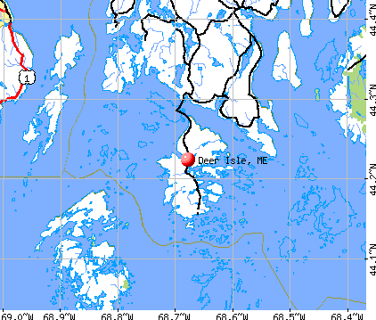
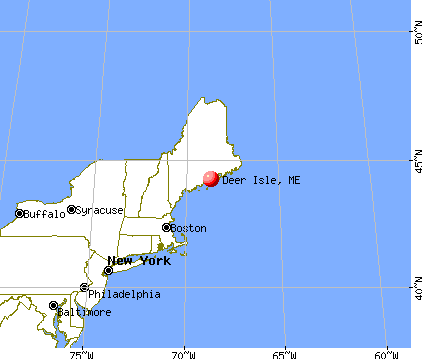
Deer Isle, Maine

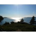
Deer Isle: from the obseration deck @ haystack school.

Deer Isle: Lily Pond
Deer Isle: Mid Day Sept. - from Hitz Point - Sylvester's Cove
- add
your
Submit your own pictures of this town and show them to the world
- OSM Map
- General Map
- Google Map
- MSN Map
Population change since 2000: +5.3%
 |
| Males: 926 | |
| Females: 1,049 |
| Median resident age: | 51.6 years |
| Maine median age: | 43.0 years |
Zip codes: 04627.
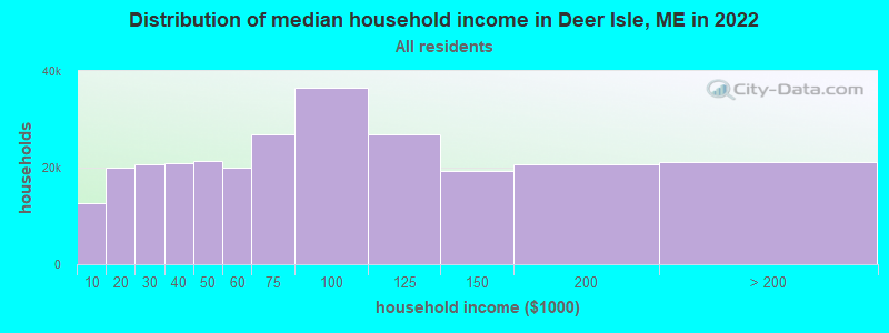
| Deer Isle: | $59,915 |
| ME: | $69,543 |
Estimated per capita income in 2022: $34,263 (it was $16,875 in 2000)
Deer Isle town income, earnings, and wages data
Estimated median house or condo value in 2022: $311,301 (it was $108,700 in 2000)
| Deer Isle: | $311,301 |
| ME: | $290,600 |
Mean prices in 2022: all housing units: $379,336; detached houses: $396,802; townhouses or other attached units: $600,716; in 2-unit structures: $274,479; in 3-to-4-unit structures: $212,346; in 5-or-more-unit structures: $146,369; mobile homes: $158,183; occupied boats, rvs, vans, etc.: $16,454
Detailed information about poverty and poor residents in Deer Isle, ME
Compare current foreclosures near Deer Isle, ME:
| Photo | Address | Area | Beds / Baths | Price | Details |
|---|---|---|---|---|---|

|
#1
Alder Ln
Deer Isle, ME 04627
|
- sq. feet
|
- baths - beds |
show details | |

|
#2
Harborside Rd
Harborside, ME 04642
|
- sq. feet
|
- baths - beds |
show details | |

|
#3
Goose Falls Rd
Harborside, ME 04642
|
- sq. feet
|
- baths - beds |
show details | |

|
#4
Pond St
Vinalhaven, ME 04863
|
- sq. feet
|
- baths - beds |
show details | |

|
Check over 1 million property listings on Foreclosure.com!
|
browse all offers | |||

- 1,92997.7%White alone
- 191.0%Two or more races
- 100.5%American Indian alone
- 90.5%Hispanic
- 40.2%Black alone
- 40.2%Asian alone

Races in Deer Isle detailed stats: ancestries, foreign born residents, place of birth
According to our research of Maine and other state lists, there were 2 registered sex offenders living in Deer Isle, Maine as of May 23, 2024.
The ratio of all residents to sex offenders in Deer Isle is 988 to 1.
The ratio of registered sex offenders to all residents in this city is lower than the state average.
 Recent articles from our blog. Our writers, many of them Ph.D. graduates or candidates, create easy-to-read articles on a wide variety of topics.

 | Maine Summer Camps - Sleepaway camps (13 replies) |
| How to get to Stonington - Deer Isle from Portland or Bangor....? (6 replies) |
| Little guidance on Oct. vacation please (12 replies) |
| Tick tock (54 replies) |
| Opinions on Little Deer Isle (10 replies) |
| Where in Maine Would You Live if You Could? (98 replies) |
Latest news from Deer Isle, ME collected exclusively by city-data.com from local newspapers, TV, and radio stations
Deer Isle, ME City Guides:
Ancestries: English (33.2%), United States (20.8%), Irish (10.0%), Scottish (8.2%), German (6.3%), French (5.4%).
Current Local Time: EST time zone
Incorporated on 02/02/1789
Elevation: 30 feet
Land area: 29.7 square miles.
Population density: 67 people per square mile (very low).
25 residents are foreign born
| This town: | 1.3% |
| Maine: | 2.9% |
| Deer Isle town: | 0.9% ($991) |
| Maine: | 1.5% ($1,417) |
Nearest city with pop. 50,000+: Portland, ME  (88.2 miles , pop. 64,249).
Nearest city with pop. 200,000+: Boston, MA (179.1 miles , pop. 589,141).
Nearest city with pop. 1,000,000+: Bronx, NY (353.0 miles , pop. 1,332,650).
Nearest cities:
), ), Latitude: 44.22 N, Longitude: 68.68 W
Area code: 207

Single-family new house construction building permits:
- 2022: 7 buildings, average cost: $262,300
- 2021: 7 buildings, average cost: $249,600
- 2020: 5 buildings, average cost: $309,600
- 2019: 8 buildings, average cost: $258,100
- 2018: 8 buildings, average cost: $258,100
- 2017: 7 buildings, average cost: $116,700
- 2016: 4 buildings, average cost: $187,500
- 2010: 16 buildings, average cost: $140,900
- 2009: 11 buildings, average cost: $99,200
- 2008: 6 buildings, average cost: $100,000
- 2007: 70 buildings, average cost: $43,900
- 2006: 17 buildings, average cost: $67,200
- 2005: 20 buildings, average cost: $67,200
- 2004: 18 buildings, average cost: $83,700
- 2003: 17 buildings, average cost: $120,800
- 2002: 15 buildings, average cost: $99,000
- 2001: 14 buildings, average cost: $132,500
- 2000: 20 buildings, average cost: $73,900
- 1999: 15 buildings, average cost: $71,700
- 1998: 11 buildings, average cost: $66,500
- 1997: 13 buildings, average cost: $65,700


| Here: | 3.6% |
| Maine: | 3.4% |


- Construction (14.0%)
- Agriculture, forestry, fishing & hunting (10.8%)
- Health care (9.3%)
- Educational services (7.4%)
- Accommodation & food services (6.0%)
- Food & beverage stores (4.9%)
- Arts, entertainment, recreation (4.8%)

- Construction (22.0%)
- Agriculture, forestry, fishing & hunting (18.7%)
- Arts, entertainment, recreation (5.6%)
- Groceries & related products merchant wholesalers (4.2%)
- Food & beverage stores (4.2%)
- Accommodation & food services (3.7%)
- Building material & garden equipment & supplies dealers (3.3%)

- Health care (17.1%)
- Educational services (11.9%)
- Accommodation & food services (8.5%)
- Food & beverage stores (5.7%)
- Construction (5.2%)
- Professional, scientific, technical services (4.9%)
- Arts, entertainment, recreation (3.9%)

- Fishing, hunting, and forestry occupations (10.9%)
- Other management occupations, except farmers and farm managers (7.2%)
- Carpenters (5.5%)
- Other sales and related occupations, including supervisors (5.0%)
- Bookkeeping, accounting, and auditing clerks (3.8%)
- Building and grounds cleaning and maintenance occupations (3.7%)
- Other production occupations, including supervisors (2.6%)

- Fishing, hunting, and forestry occupations (19.0%)
- Carpenters (10.1%)
- Other management occupations, except farmers and farm managers (5.9%)
- Other sales and related occupations, including supervisors (5.2%)
- Construction traders workers except carpenters, electricians, painters, plumbers, and construction laborers (4.2%)
- Other production occupations, including supervisors (4.0%)
- Pipelayers, plumbers, pipefitters, and steamfitters (3.3%)

- Other management occupations, except farmers and farm managers (8.8%)
- Bookkeeping, accounting, and auditing clerks (7.5%)
- Building and grounds cleaning and maintenance occupations (5.7%)
- Secretaries and administrative assistants (5.2%)
- Other sales and related occupations, including supervisors (4.9%)
- Preschool, kindergarten, elementary, and middle school teachers (3.9%)
- Child care workers (3.9%)
Average climate in Deer Isle, Maine
Based on data reported by over 4,000 weather stations


(lower is better)

Air Quality Index (AQI) level in 2023 was 61.9. This is about average.
| City: | 61.9 |
| U.S.: | 72.6 |

Carbon Monoxide (CO) [ppm] level in 2023 was 0.172. This is significantly better than average. Closest monitor was 23.1 miles away from the city center.
| City: | 0.172 |
| U.S.: | 0.251 |


Sulfur Dioxide (SO2) [ppb] level in 2023 was 0.0636. This is significantly better than average. Closest monitor was 18.4 miles away from the city center.
| City: | 0.0636 |
| U.S.: | 1.5147 |

Ozone [ppb] level in 2023 was 36.9. This is about average. Closest monitor was 5.0 miles away from the city center.
| City: | 36.9 |
| U.S.: | 33.3 |


Particulate Matter (PM2.5) [µg/m3] level in 2023 was 4.90. This is significantly better than average. Closest monitor was 23.1 miles away from the city center.
| City: | 4.90 |
| U.S.: | 8.11 |
Earthquake activity:
Deer Isle-area historical earthquake activity is significantly above Maine state average. It is 79% smaller than the overall U.S. average.On 10/16/2012 at 23:12:25, a magnitude 4.7 (4.7 ML, Depth: 10.0 mi, Class: Light, Intensity: IV - V) earthquake occurred 107.7 miles away from Deer Isle center
On 4/20/2002 at 10:50:47, a magnitude 5.3 (5.3 ML, Depth: 3.0 mi, Class: Moderate, Intensity: VI - VII) earthquake occurred 249.0 miles away from the city center
On 4/20/2002 at 10:50:47, a magnitude 5.2 (5.2 MB, 4.2 MS, 5.2 MW, 5.0 MW) earthquake occurred 249.9 miles away from the city center
On 1/19/1982 at 00:14:42, a magnitude 4.7 (4.5 MB, 4.7 MD, 4.5 LG) earthquake occurred 154.1 miles away from Deer Isle center
On 10/7/1983 at 10:18:46, a magnitude 5.3 (5.1 MB, 5.3 LG, 5.1 ML) earthquake occurred 282.0 miles away from Deer Isle center
On 2/26/1999 at 03:38:43, a magnitude 3.8 (3.8 LG, Depth: 2.0 mi, Class: Light, Intensity: II - III) earthquake occurred 45.3 miles away from Deer Isle center
Magnitude types: regional Lg-wave magnitude (LG), body-wave magnitude (MB), duration magnitude (MD), local magnitude (ML), surface-wave magnitude (MS), moment magnitude (MW)
Natural disasters:
The number of natural disasters in Hancock County (18) is near the US average (15).Major Disasters (Presidential) Declared: 11
Emergencies Declared: 6
Causes of natural disasters: Floods: 9, Storms: 8, Snows: 5, Blizzard: 1, Heavy Rain: 1, Hurricane: 1, Ice Storm: 1, Landslide: 1, Snowfall: 1, Wind: 1, Winter Storm: 1, Other: 2 (Note: some incidents may be assigned to more than one category).

Hospitals and medical centers in Deer Isle:
Colleges/universities with over 2000 students nearest to Deer Isle:
- Husson University (about 43 miles; Bangor, ME; Full-time enrollment: 2,421)
- University of Maine (about 47 miles; Orono, ME; FT enrollment: 8,931)
- University of Maine at Augusta (about 56 miles; Augusta, ME; FT enrollment: 3,204)
- University of Maine at Farmington (about 79 miles; Farmington, ME; FT enrollment: 2,036)
- Southern Maine Community College (about 87 miles; South Portland, ME; FT enrollment: 4,666)
- University of Southern Maine (about 89 miles; Portland, ME; FT enrollment: 6,647)
- Saint Joseph's College of Maine (about 94 miles; Standish, ME; FT enrollment: 2,010)
Public high school in Deer Isle:
- DEER ISLE-STONINGTON HIGH SCH (Students: 182, Location: 251 NORTH DEER ISLE ROAD, Grades: 9-12)
Public elementary/middle school in Deer Isle:
- DEER ISLE-STONINGTON ELEMENTARY SCH (Students: 240, Location: 249 NORTH DEER ISLE ROAD, Grades: KG-8)
Points of interest:
Notable locations in Deer Isle: The Wood Landing (A), Salome Sellers House Museum (B), Memorial Ambulance Corps (C), Deer Isle Volunteer Fire Department (D). Display/hide their locations on the map
Church in Deer Isle: Advent Christian Fellowship Church (A). Display/hide its location on the map
Cemeteries: Mount Adams Cemetery (1), Reach Cemetery (2), Witherspoon Cemetery (3), Quinn Cemetery (4), Eaton Cemetery (5), Forest Hill Cemetery (6). Display/hide their locations on the map
Lakes, reservoirs, and swamps: Torrey Pond (A), Mill Pond (B), Toffet Pond (C), Holt Pond (D), Olivers Pond (E), Lily Pond (F), Labrador Swamp (G). Display/hide their locations on the map
Creek: Fish Creek (A). Display/hide its location on the map
Beaches: The Brook Beach (A), Brook Beach (B), North Point Beach (C), Three Island Beach (D), Driftwood Beach (E), Steep Bank Beach (F), Walton Beach (G), Double Beach (H), Bear Island Beach (I). Display/hide their locations on the map
Hotel: Goose Cove Lodge (Goose Cove Road) (1). Display/hide its approximate location on the map
Drinking water stations with addresses in Deer Isle and their reported violations in the past:
MSU 76 DEER ISLE/STONINGTON K-8 SCHOOL (Population served: 264, Groundwater):Past monitoring violations:MSU 76 DEER ISLE-STONINGTON JR/SR HS (Population served: 200, Groundwater):
- 3 regular monitoring violations
Past monitoring violations:ISLAND COUNTRY CLUB INC (Population served: 130, Groundwater):
- Follow-up Or Routine LCR Tap M/R - In JUL-11-2003, Contaminant: Lead and Copper Rule. Follow-up actions: St Public Notif requested (NOV-17-2005), St Violation/Reminder Notice (NOV-17-2005), St Compliance achieved (JAN-15-2008)
Past monitoring violations:MSU 76 SEDGWICK ELEMENTARY SCHOOL (Population served: 130, Groundwater):
- 3 routine major monitoring violations
- One regular monitoring violation
Past monitoring violations:HAYSTACK MTN SCHL OF CRAFTS #1 (Address: 13 DOW ROAD , Population served: 110, Surface water):
- Follow-up Or Routine LCR Tap M/R - In JAN-01-2007, Contaminant: Lead and Copper Rule. Follow-up actions: St Public Notif requested (FEB-20-2007), St Violation/Reminder Notice (FEB-20-2007), St Public Notif received (MAR-12-2007), St Compliance achieved (JUN-28-2007)
- Follow-up Or Routine LCR Tap M/R - In JUL-11-2004, Contaminant: Lead and Copper Rule. Follow-up actions: St Violation/Reminder Notice (FEB-23-2005), St Public Notif requested (FEB-23-2005), St Public Notif received (AUG-05-2005), St Compliance achieved (SEP-06-2005)
- 3 routine major monitoring violations
Past health violations:MSU 76 BROOKLIN NEW ELEMENTARY SCHOOL (Population served: 100, Groundwater):
- MCL, Monthly (TCR) - In JUN-2014, Contaminant: Coliform. Follow-up actions: St Formal NOV issued (JUN-30-2014), St Public Notif requested (JUN-30-2014)
- MCL, Monthly (TCR) - In MAY-2014, Contaminant: Coliform. Follow-up actions: St Formal NOV issued (JUN-05-2014), St Public Notif requested (JUN-05-2014)
- MCL, Monthly (TCR) - In JUL-2013, Contaminant: Coliform. Follow-up actions: St Public Notif requested (AUG-19-2013), St Formal NOV issued (AUG-19-2013), St Compliance achieved (AUG-28-2013), St Public Notif received (SEP-17-2013)
- MCL, Monthly (TCR) - In JUN-2011, Contaminant: Coliform. Follow-up actions: St Public Notif requested (JUN-17-2011), St Formal NOV issued (JUN-17-2011), St Public Notif received (JUL-06-2011), St Compliance achieved (JUL-21-2011)
- MCL, Monthly (TCR) - Between APR-2009 and JUN-2009, Contaminant: Coliform. Follow-up actions: St Public Notif requested (JUN-01-2009), St Formal NOV issued (JUN-01-2009), St Public Notif received (JUL-07-2009), St Compliance achieved (JUN-07-2011)
Past health violations:Past monitoring violations:
- MCL, Monthly (TCR) - In OCT-2011, Contaminant: Coliform. Follow-up actions: St Public Notif requested (OCT-17-2011), St Formal NOV issued (OCT-17-2011), St Compliance achieved (AUG-09-2012)
- MCL, Monthly (TCR) - In SEP-2011, Contaminant: Coliform. Follow-up actions: St Public Notif requested (SEP-26-2011), St Formal NOV issued (SEP-26-2011), St Public Notif received (OCT-05-2011), St Compliance achieved (AUG-09-2012)
- Water Quality Parameter M/R - Between JAN-2011 and MAR-2011, Contaminant: Lead and Copper Rule. Follow-up actions: St Compliance achieved (MAY-16-2011), St Public Notif requested (AUG-19-2011), St Formal NOV issued (AUG-19-2011), St Public Notif received (SEP-28-2012)
- Follow-up Or Routine LCR Tap M/R - In JUL-01-2009, Contaminant: Lead and Copper Rule. Follow-up actions: St Public Notif requested (AUG-26-2009), St Formal NOV issued (AUG-26-2009), St Public Notif received (SEP-29-2009), St Compliance achieved (AUG-29-2011)
- 49 regular monitoring violations
Drinking water stations with addresses in Deer Isle that have no violations reported:
| This town: | 2.0 people |
| Maine: | 2.3 people |
| This town: | 57.4% |
| Whole state: | 62.9% |
| This town: | 8.9% |
| Whole state: | 9.4% |
Likely homosexual households (counted as self-reported same-sex unmarried-partner households)
- Lesbian couples: 0.6% of all households
- Gay men: 0.2% of all households
| This town: | 8.8% |
| Whole state: | 10.9% |
| This town: | 2.9% |
| Whole state: | 4.1% |
63 people in nursing homes in 2000
Banks with branches in Deer Isle (2011 data):
- Bar Harbor Bank & Trust: Deer Isle Branch at 25 Church Street, branch established on 1974/02/25. Info updated 2007/04/24: Bank assets: $1,166.8 mil, Deposits: $723.6 mil, headquarters in Bar Harbor, ME, positive income, Commercial Lending Specialization, 12 total offices, Holding Company: Bar Harbor Bankshares
For population 15 years and over in Deer Isle:

- Never married: 18.7%
- Now married: 59.8%
- Separated: 0.7%
- Widowed: 10.3%
- Divorced: 10.5%
For population 25 years and over in Deer Isle:
- High school or higher: 83.0%
- Bachelor's degree or higher: 22.4%
- Graduate or professional degree: 9.5%
- Unemployed: 6.3%
- Mean travel time to work (commute): 18.0 minutes


| Here: | 11.6 |
| Maine average: | 11.2 |


Graphs represent county-level data. Detailed 2008 Election Results
Religion statistics for Deer Isle, ME (based on Hancock County data)


| Religion | Adherents | Congregations |
|---|---|---|
| Mainline Protestant | 4,691 | 58 |
| Catholic | 2,523 | 9 |
| Evangelical Protestant | 1,288 | 23 |
| Other | 820 | 11 |
| None | 45,096 | - |
Food Environment Statistics:
| This county: | 6.01 / 10,000 pop. |
| Maine: | 2.80 / 10,000 pop. |
| Hancock County: | 1.69 / 10,000 pop. |
| Maine: | 2.20 / 10,000 pop. |
| Hancock County: | 4.89 / 10,000 pop. |
| Maine: | 5.75 / 10,000 pop. |
| This county: | 21.61 / 10,000 pop. |
| State: | 11.02 / 10,000 pop. |
| Here: | 7.4% |
| Maine: | 8.2% |
| This county: | 25.4% |
| State: | 25.0% |
Strongest AM radio stations in Deer Isle:
- WDEA (1370 AM; 5 kW; ELLSWORTH, ME; Owner: CUMULUS LICENSING CORP.)
- WZON (620 AM; 5 kW; BANGOR, ME; Owner: THE ZONE CORPORATION)
- WABI (910 AM; 5 kW; BANGOR, ME; Owner: CLEAR CHANNEL BROADCASTING LICENSES, INC.)
- WRKO (680 AM; 50 kW; BOSTON, MA; Owner: ENTERCOM BOSTON LICENSE, LLC)
- WSKW (1160 AM; 10 kW; SKOWHEGAN, ME; Owner: MOUNTAIN WIRELESS, INCORPORATED)
- WEEI (850 AM; 50 kW; BOSTON, MA; Owner: ENTERCOM BOSTON LICENSE, LLC)
- WBZ (1030 AM; 50 kW; BOSTON, MA; Owner: INFINITY BROADCASTING OPERATIONS, INC.)
- WTME (780 AM; 10 kW; RUMFORD, ME; Owner: MOUNTAIN VALLEY BROADCASTING, INC.)
- WCRN (830 AM; 50 kW; WORCESTER, MA; Owner: CARTER BROADCASTING CORPORATION)
- WFAU (1280 AM; 5 kW; GARDINER, ME; Owner: CAPSTAR TX LIMITED PARTNERSHIP)
- WRKD (1450 AM; 1 kW; ROCKLAND, ME; Owner: CLEAR CHANNEL BROADCASTING LICENSES, INC.)
- WNNZ (640 AM; 50 kW; WESTFIELD, MA; Owner: CLEAR CHANNEL BROADCASTING LICENSES, INC.)
- WMTW (870 AM; 10 kW; GORHAM, ME; Owner: RADIO PARTNERS OF MAINE, L.P.)
Strongest FM radio stations in Deer Isle:
- WERU-FM (89.9 FM; BLUE HILL, ME; Owner: SALT POND COMMUNITY B/C COMPANY)
- WFZX (101.7 FM; SEARSPORT, ME; Owner: CLEAR CHANNEL BROADCASTING LICENSES, INC.)
- WMEP (90.5 FM; CAMDEN, ME; Owner: MAINE PUBLIC BROADCASTING CORP.)
- WQSS (102.5 FM; CAMDEN, ME; Owner: CLEAR CHANNEL BROADCASTING LICENSES, INC.)
- WBFB (104.7 FM; BELFAST, ME; Owner: CLEAR CHANNEL BROADCASTING LICENSES, INC.)
- WMCM (103.3 FM; ROCKLAND, ME; Owner: CLEAR CHANNEL BROADCASTING LICENSES, INC.)
- WWMJ (95.7 FM; ELLSWORTH, ME; Owner: CUMULUS LICENSING CORP.)
- WWBX (97.1 FM; BANGOR, ME; Owner: CLEAR CHANNEL BROADCASTING LICENSES, INC.)
- WKIT-FM (100.3 FM; BREWER, ME; Owner: THE ZONE CORPORATION)
- WBQX (106.9 FM; THOMASTON, ME; Owner: MARINER BROADCASTING LIMITED PARTNER)
- WNSX (97.7 FM; WINTER HARBOR, ME; Owner: CLEAR CHANNEL BROADCASTING LICENSES, INC.)
- WBYA (105.5 FM; ISLESBORO, ME; Owner: MARINER BROADCASTING LIMTED PARTNERSHIP)
- WMEH (90.9 FM; BANGOR, ME; Owner: MAINE PUBLIC BROADCASTING CORPORATION)
- WEZQ (92.9 FM; BANGOR, ME; Owner: CUMULUS LICENSING CORP.)
- WLKE (99.1 FM; BAR HARBOR, ME; Owner: CLEAR CHANNEL BROADCASTING LICENSES, INC.)
- Deer Isle, Maine
- Fatal accident count12
- Vehicles involved in fatal accidents13
- Fatal accidents involving drunk persons:3
- Fatalities13
- Persons involved in fatal accidents18
- Pedestrians involved in fatal accidents0
- Maine average
- Fatal accident count1948
- Vehicles involved in fatal accidents2817
- Fatal accidents involving drunk persons669
- Fatalities2158
- Persons involved in fatal accidents4433
- Pedestrians involved in fatal accidents168
- National Bridge Inventory (NBI) Statistics
- 1Number of bridges
- 249ft / 76.3mTotal length
- 4,700Total average daily traffic
- 517Total average daily truck traffic
- 4,239Total future (year 2036) average daily traffic
FCC Registered Cell Phone Towers:
1- 409 North Deer Isle Rd (Lat: 44.250694 Lon: -68.680917), Type: Ltower, Structure height: 58.2 m, Call Sign: KNKN831
Assigned Frequencies: 869.040 MHz, 869.040 MHz, 824.040 MHz, 824.040 MHz, 890.010 MHz, 890.010 MHz, 845.010 MHz, 845.010 MHzGrant Date: 09/22/2020, Expiration Date: 10/01/2030, Certifier: Michael P GogginRegistrant: At&t Services, Inc., 208 S Akard St, 20f, Dallas, TX 75202, Phone: (855) 699-7073, Fax: (214) 746-6410, Email:
FCC Registered Antenna Towers:
6- Leslie N Nixon, 409 North Deer Isle Road (Lat: 44.251278 Lon: -68.681306), Type: 57.9, Overall height: 57.9 m, Registrant: Global Tower, LLC, Fcc-Contact@gtpsites.Com, , Boca -Raton, Phone: (561) 995-0320
- Leslie N Nixon, 409 North Deer Isle Road (Lat: 44.250694 Lon: -68.680917), Type: 57.9, Overall height: 57.9 m, Registrant: Global Tower, LLC, Fc-Contact@gtpsites.Com, , Boca -Raton, Phone: (561) 995-0320
- Leslie N Nixon, 409 North Deer Isle Road (Lat: 44.250694 Lon: -68.680917), Type: 57.9, Overall height: 57.9 m, Registrant: Global Tower, LLC, Fc-Contact@gtpsites.Com, , Boca -Raton, Phone: (561) 995-0320
- Leslie N Nixon, 409 North Deer Isle Road (Lat: 44.250694 Lon: -68.680917), Type: 59.4, Structure height: 23009 m, Overall height: 59.4 m, Registrant: Global Tower, LLC, Fcc-Contact@gtpsites.Com, , Boca -Raton, Phone: (561) 995-0320
- Leslie N Nixon, 409 North Deer Isle Road (Lat: 44.250694 Lon: -68.680917), Type: 59.4, Structure height: 23009 m, Overall height: 59.4 m, Registrant: Global Tower, LLC, Fcc-Contact@gtpsites.Com, , Boca -Raton, Phone: (561) 995-0320
- Kristen Cesana, 409 North Deer Isle Road (Lat: 44.250694 Lon: -68.680917), Type: 59.4, Structure height: 23009 m, Overall height: 59.4 m, Registrant: American Towers, LLC., Faa-Fcc@americantower.Com, , Wobur-n, Phone: (678) 265-6770
FCC Registered Amateur Radio Licenses:
11 (See the full list of FCC Registered Amateur Radio Licenses in Deer Isle)
- 80.6%Fuel oil, kerosene, etc.
- 11.0%Wood
- 6.4%Bottled, tank, or LP gas
- 2.0%Electricity

- 65.6%Fuel oil, kerosene, etc.
- 21.6%Electricity
- 7.2%Wood
- 5.6%Bottled, tank, or LP gas
Deer Isle compared to Maine state average:
- Unemployed percentage below state average.
- Black race population percentage significantly below state average.
- Hispanic race population percentage significantly below state average.
- Median age significantly above state average.
- Foreign-born population percentage significantly below state average.
- Length of stay since moving in significantly above state average.
- Number of rooms per house significantly below state average.
- House age significantly below state average.
- Institutionalized population percentage above state average.
- Number of college students below state average.

|
Total of 4 patent applications in 2008-2024.