Deblois, Maine
Submit your own pictures of this town and show them to the world
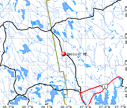
- OSM Map
- General Map
- Google Map
- MSN Map
Population change since 2000: +16.3%
| Males: 30 | |
| Females: 27 |
| Median resident age: | 45.8 years |
| Maine median age: | 43.0 years |
Zip code: 04622
| Deblois: | $38,159 |
| ME: | $69,543 |
Estimated per capita income in 2022: $26,666 (it was $11,814 in 2000)
Estimated median house or condo value in 2022: $92,992 (it was $38,300 in 2000)
| Deblois: | $92,992 |
| ME: | $290,600 |
Mean prices in 2022: all housing units: $208,896; detached houses: $229,377; townhouses or other attached units: $190,242; in 2-unit structures: $139,050; in 3-to-4-unit structures: $456,045; in 5-or-more-unit structures: $413,457; mobile homes: $94,515; occupied boats, rvs, vans, etc.: $45,679


- 5494.7%White alone
- 23.5%Two or more races
- 11.8%American Indian alone

According to our research of Maine and other state lists, there was 1 registered sex offender living in Deblois, Maine as of May 26, 2024.
The ratio of all residents to sex offenders in Deblois is 57 to 1.
 Recent articles from our blog. Our writers, many of them Ph.D. graduates or candidates, create easy-to-read articles on a wide variety of topics.

 | Maine weather thread (3207 replies) |
| Alewives (17 replies) |
| Hancock County, Maine wanting to know more (9 replies) |
| Which Maine town do you prefer? (42 replies) |
| What is the weather REALLY like? (29 replies) |
| Maine's Own Off-Topic Thread! (2485 replies) |
Latest news from Deblois, ME collected exclusively by city-data.com from local newspapers, TV, and radio stations
Ancestries: English (32.7%), Irish (10.2%), Scottish (8.2%), Scotch-Irish (4.1%).
Current Local Time: EST time zone
Incorporated on 03/04/1852
Elevation: 204 feet
Land area: 33.3 square miles.
Population density: 1.7 people per square mile (very low).
| Deblois town: | 0.5% ($200) |
| Maine: | 1.5% ($1,417) |
Nearest city with pop. 50,000+: Portland, ME  (134.9 miles , pop. 64,249).
Nearest city with pop. 200,000+: Boston, MA (227.8 miles , pop. 589,141).
Nearest city with pop. 1,000,000+: Bronx, NY (401.4 miles , pop. 1,332,650).
Nearest cities:
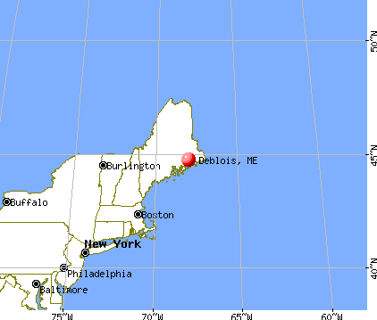
), ), Latitude: 44.73 N, Longitude: 67.99 W
Area code commonly used in this area: 207


Single-family new house construction building permits:
- 2020: 1 building, cost: $52,500
- 2018: 1 building, cost: $7,000
- 2008: 1 building, cost: $58,000
- 2006: 1 building, cost: $24,000
- 2005: 4 buildings, average cost: $11,800
- 2004: 1 building, cost: $33,500
- 2003: 2 buildings, average cost: $27,500
- 2002: 2 buildings, average cost: $30,000


| Here: | 4.0% |
| Maine: | 3.4% |

Average climate in Deblois, Maine
Based on data reported by over 4,000 weather stations


(lower is better)

Air Quality Index (AQI) level in 2023 was 50.1. This is significantly better than average.
| City: | 50.1 |
| U.S.: | 72.6 |

Ozone [ppb] level in 2023 was 31.5. This is about average. Closest monitor was 23.1 miles away from the city center.
| City: | 31.5 |
| U.S.: | 33.3 |
Earthquake activity:
Deblois-area historical earthquake activity is significantly above Maine state average. It is 83% smaller than the overall U.S. average.On 10/16/2012 at 23:12:25, a magnitude 4.7 (4.7 ML, Depth: 10.0 mi, Class: Light, Intensity: IV - V) earthquake occurred 153.7 miles away from Deblois center
On 4/20/2002 at 10:50:47, a magnitude 5.3 (5.3 ML, Depth: 3.0 mi, Class: Moderate, Intensity: VI - VII) earthquake occurred 281.4 miles away from Deblois center
On 4/20/2002 at 10:50:47, a magnitude 5.2 (5.2 MB, 4.2 MS, 5.2 MW, 5.0 MW) earthquake occurred 282.5 miles away from Deblois center
On 1/19/1982 at 00:14:42, a magnitude 4.7 (4.5 MB, 4.7 MD, 4.5 LG) earthquake occurred 198.4 miles away from the city center
On 10/7/1983 at 10:18:46, a magnitude 5.3 (5.1 MB, 5.3 LG, 5.1 ML) earthquake occurred 318.7 miles away from Deblois center
On 10/3/2006 at 00:07:38, a magnitude 3.7 (3.7 MD, Depth: 6.2 mi, Class: Light, Intensity: II - III) earthquake occurred 26.2 miles away from Deblois center
Magnitude types: regional Lg-wave magnitude (LG), body-wave magnitude (MB), duration magnitude (MD), local magnitude (ML), surface-wave magnitude (MS), moment magnitude (MW)
Natural disasters:
The number of natural disasters in Washington County (20) is greater than the US average (15).Major Disasters (Presidential) Declared: 14
Emergencies Declared: 6
Causes of natural disasters: Floods: 11, Storms: 10, Snows: 5, Winds: 2, Winter Storms: 2, Blizzard: 1, Heavy Rain: 1, Hurricane: 1, Ice Storm: 1, Landslide: 1, Snowfall: 1, Other: 2 (Note: some incidents may be assigned to more than one category).

Airports located in Deblois:
- Deblois Flight Strip Airport (43B) (Runways: 1, Local Ops: 100)
Colleges/universities with over 2000 students nearest to Deblois:
- University of Maine (about 36 miles; Orono, ME; Full-time enrollment: 8,931)
- Husson University (about 40 miles; Bangor, ME; FT enrollment: 2,421)
- University of Maine at Augusta (about 94 miles; Augusta, ME; FT enrollment: 3,204)
- University of Maine at Farmington (about 107 miles; Farmington, ME; FT enrollment: 2,036)
- Southern Maine Community College (about 134 miles; South Portland, ME; FT enrollment: 4,666)
- University of Southern Maine (about 136 miles; Portland, ME; FT enrollment: 6,647)
- Saint Joseph's College of Maine (about 139 miles; Standish, ME; FT enrollment: 2,010)
Points of interest:
Notable locations in Deblois: Morse Camp (A), Deblois Volunteer Fire Department (B). Display/hide their locations on the map
Lakes and swamps: Pineo Pond (A), Spectacle Ponds (B), Flynn Pond (C), Merrit Pond (D), Denbow Heath (E), Gowen Meadow (F), Heath Brook Heath (G). Display/hide their locations on the map
Streams, rivers, and creeks: Middle Brook (A), Crotch Camp Brook (B), Longfellow Brook (C). Display/hide their locations on the map
Drinking water stations with addresses in Deblois and their reported violations in the past:
C & D CORP - DEBLOIS (Population served: 32, Groundwater):Past health violations:Past monitoring violations:
- MCL, Average - Between JUL-2007 and SEP-2007, Contaminant: Arsenic. Follow-up actions: St Public Notif requested (NOV-06-2007), St Formal NOV issued (NOV-06-2007), St Public Notif received (NOV-06-2007), St Compliance achieved (AUG-20-2008)
- Follow-up Or Routine LCR Tap M/R - In JAN-11-2006, Contaminant: Lead and Copper Rule. Follow-up actions: St Violation/Reminder Notice (JAN-11-2006), St Public Notif requested (JAN-11-2006), St Compliance achieved (MAR-28-2007), St Intentional no-action (AUG-23-2011)
- One routine major monitoring violation
- One regular monitoring violation
| This town: | 2.1 people |
| Maine: | 2.3 people |
| This town: | 63.0% |
| Whole state: | 62.9% |
| This town: | 7.4% |
| Whole state: | 9.4% |
No gay or lesbian households reported
| This town: | 20.0% |
| Whole state: | 10.9% |
| This town: | 5.7% |
| Whole state: | 4.1% |
For population 15 years and over in Deblois:

- Never married: 6.9%
- Now married: 55.2%
- Separated: 0.0%
- Widowed: 13.8%
- Divorced: 24.1%
For population 25 years and over in Deblois:
- High school or higher: 66.7%
- Bachelor's degree or higher: 14.8%
- Graduate or professional degree: 0.0%
- Mean travel time to work (commute): 7.0 minutes


| Here: | 10.1 |
| Maine average: | 11.2 |
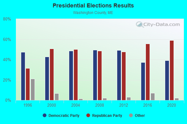

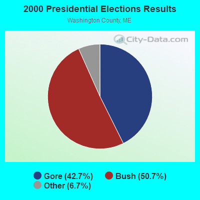
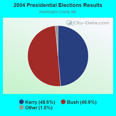

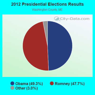

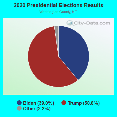
Graphs represent county-level data. Detailed 2008 Election Results
Religion statistics for Deblois, ME (based on Washington County data)
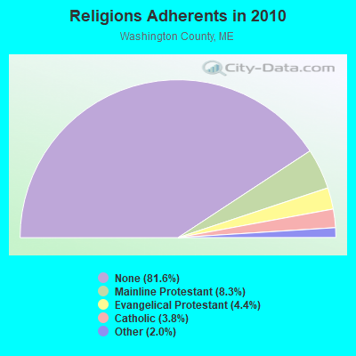
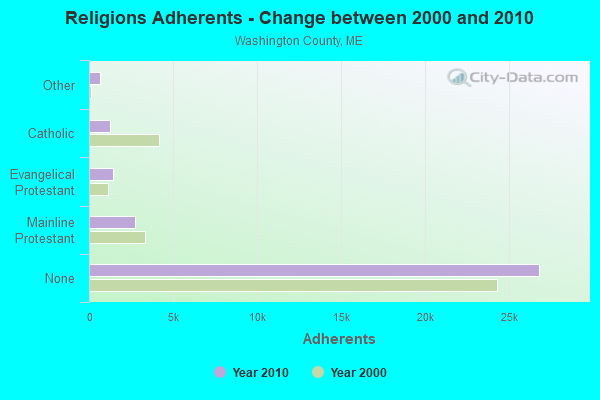
| Religion | Adherents | Congregations |
|---|---|---|
| Mainline Protestant | 2,731 | 37 |
| Evangelical Protestant | 1,442 | 31 |
| Catholic | 1,238 | 10 |
| Other | 648 | 13 |
| None | 26,797 | - |
Food Environment Statistics:
| Washington County: | 4.89 / 10,000 pop. |
| State: | 2.80 / 10,000 pop. |
| Washington County: | 1.22 / 10,000 pop. |
| Maine: | 2.20 / 10,000 pop. |
| Here: | 9.78 / 10,000 pop. |
| State: | 5.75 / 10,000 pop. |
| Washington County: | 11.31 / 10,000 pop. |
| Maine: | 11.02 / 10,000 pop. |
| This county: | 9.4% |
| Maine: | 8.2% |
| This county: | 28.3% |
| Maine: | 25.0% |
Strongest AM radio stations in Deblois:
- WZON (620 AM; 5 kW; BANGOR, ME; Owner: THE ZONE CORPORATION)
- WDEA (1370 AM; 5 kW; ELLSWORTH, ME; Owner: CUMULUS LICENSING CORP.)
- WABI (910 AM; 5 kW; BANGOR, ME; Owner: CLEAR CHANNEL BROADCASTING LICENSES, INC.)
- WRKO (680 AM; 50 kW; BOSTON, MA; Owner: ENTERCOM BOSTON LICENSE, LLC)
- WSKW (1160 AM; 10 kW; SKOWHEGAN, ME; Owner: MOUNTAIN WIRELESS, INCORPORATED)
- WEEI (850 AM; 50 kW; BOSTON, MA; Owner: ENTERCOM BOSTON LICENSE, LLC)
- WBZ (1030 AM; 50 kW; BOSTON, MA; Owner: INFINITY BROADCASTING OPERATIONS, INC.)
- WCRN (830 AM; 50 kW; WORCESTER, MA; Owner: CARTER BROADCASTING CORPORATION)
- WNNZ (640 AM; 50 kW; WESTFIELD, MA; Owner: CLEAR CHANNEL BROADCASTING LICENSES, INC.)
- WTME (780 AM; 10 kW; RUMFORD, ME; Owner: MOUNTAIN VALLEY BROADCASTING, INC.)
- WKOX (1200 AM; 50 kW; FRAMINGHAM, MA; Owner: CAPSTAR TX LIMITED PARTNERSHIP)
- WALE (990 AM; 50 kW; GREENVILLE, RI; Owner: NORTH AMERICAN BROADCASTING CO., INC.)
- WWZN (1510 AM; 50 kW; BOSTON, MA; Owner: ROSE CITY RADIO CORPORATION)
Strongest FM radio stations in Deblois:
- WNSX (97.7 FM; WINTER HARBOR, ME; Owner: CLEAR CHANNEL BROADCASTING LICENSES, INC.)
- WBQI (107.7 FM; BAR HARBOR, ME; Owner: MARINER BROADCASTING, L.P.)
- WHCF (88.5 FM; BANGOR, ME; Owner: BANGOR BAPTIST CHURCH)
- WWMJ (95.7 FM; ELLSWORTH, ME; Owner: CUMULUS LICENSING CORP.)
- WVOM (103.9 FM; HOWLAND, ME; Owner: CLEAR CHANNEL BROADCASTING LICENSES, INC.)
- WMEH (90.9 FM; BANGOR, ME; Owner: MAINE PUBLIC BROADCASTING CORPORATION)
- WEZQ (92.9 FM; BANGOR, ME; Owner: CUMULUS LICENSING CORP.)
- WLKE (99.1 FM; BAR HARBOR, ME; Owner: CLEAR CHANNEL BROADCASTING LICENSES, INC.)
- WERU-FM (89.9 FM; BLUE HILL, ME; Owner: SALT POND COMMUNITY B/C COMPANY)
- WKIT-FM (100.3 FM; BREWER, ME; Owner: THE ZONE CORPORATION)
- WBFB (104.7 FM; BELFAST, ME; Owner: CLEAR CHANNEL BROADCASTING LICENSES, INC.)
TV broadcast stations around Deblois:
- WMEB-TV (Channel 12; ORONO, ME; Owner: MAINE PUBLIC BROADCASTING CORPORATION)
- National Bridge Inventory (NBI) Statistics
- 1Number of bridges
- 13ft / 3.8mTotal length
- 736Total average daily traffic
- 36Total average daily truck traffic
- 1,178Total future (year 2036) average daily traffic
FCC Registered Antenna Towers:
6- Mark L Gartley, Eleanor May Road (Lat: 44.743361 Lon: -67.962028), Type: 59.4, Overall height: 57.9 m, Registrant: United States Cellular Corporation, Renee.Mazur@uscellular.Com, , Chica-go, Phone: (773) 399-8900
- Erik Brooks, Eleanor May Road (Lat: 44.743361 Lon: -67.962028), Type: 59.4, Structure height: 23029 m, Overall height: 57.9 m, Registrant: Holland & Knight LLP, Pconnolly@hklaw.Com, , Washi-ngton, Phone: (202) 862-5989
- Cayla Gamble, Eleanor May Road (Lat: 44.743361 Lon: -67.962028), Type: 59.4, Structure height: 23029 m, Overall height: 57.9 m, Registrant: Wilkinson Barker Knauer, LLP, Gwerner@wbklaw.Com, , Washi-ngton, Phone: (202) 383-3420
- Cayla Gamble, 241 Eleanor Mae Rd (Lat: 44.743361 Lon: -67.962028), Type: 59.4, Structure height: 23029 m, Overall height: 57.9 m, Licensee ID: C, Registrant: United States Cellular Corporation, Regulatoryaffairs@uscellular.Com, , Chica-go, Phone: (800) 510-6091
- Cayla Gamble, 241 Eleanor Mae Rd (Lat: 44.743361 Lon: -67.962028), Type: 59.4, Structure height: 23029 m, Overall height: 57.9 m, Registrant: Wilkinson Barker Knauer, LLP, Gwerner@wbklaw.Com, , Washi-ngton, Phone: (202) 383-3420
- Cayla Gamble, 241 Eleanor Mae Rd (Lat: 44.743361 Lon: -67.962028), Type: 59.4, Structure height: 23029 m, Overall height: 57.9 m, Registrant: Wilkinson Barker Knauer, LLP, Gwerner@wbklaw.Com, , Washi-ngton, Phone: (202) 383-3420
FCC Registered Broadcast Land Mobile Towers:
3- Rt 193 (Lat: 44.724250 Lon: -67.979444), Type: Tower, Structure height: 21 m, Call Sign: KNNM974, Licensee ID: L00043551,
Assigned Frequencies: 469.700 MHz, Grant Date: 02/24/2001, Expiration Date: 03/11/2011, Cancellation Date: 05/14/2011, Certifier: Floyd K Fitzpatrick, Registrant: Jasper Wyman & Son, Milbridge, ME 04658, Phone: (207) 546-3381
- On Rt 193 5 Mi Se Of Rt 9 (Lat: 44.734806 Lon: -67.998056), Call Sign: KNBM539,
Assigned Frequencies: 153.050 MHz, Grant Date: 07/24/2021, Expiration Date: 10/20/2031, Registrant: Atlantic Communications, Inc., 40 Freedom Parkway, Hermon, Maine 04401, Bangor, ME 04402-0596, Phone: (207) 848-7590, Fax: (207) 974-3151, Email:
- Lat: 44.723556 Lon: -67.979611, Call Sign: WPWE669,
Assigned Frequencies: 462.212 MHz, 462.287 MHz, 467.212 MHz, 467.287 MHz, 467.337 MHz, Grant Date: 10/30/2002, Expiration Date: 10/30/2012, Cancellation Date: 01/05/2013, Certifier: Fred Olday, Registrant: Adcon Telemetry Inc, 195 Concourse Blvd., Suite A, Santa Rosa, CA 95403, Phone: (707) 522-2277, Fax: (707) 522-2270
FCC Registered Microwave Towers:
2- DEBLOIS_USF, Eleanor May Road (Lat: 44.743361 Lon: -67.962028), Type: Gtower, Structure height: 57.9 m, Overall height: 59.4 m, Call Sign: WQQL214,
Assigned Frequencies: 6256.54 MHz, Grant Date: 12/13/2022, Expiration Date: 01/17/2033, Certifier: Steven T Campbell, Registrant: Wilkinson Barker Knauer, LLP, 1800 M Street Nw, Suite 800n, Washington, DC 20036, Phone: (202) 383-3420, Fax: (202) 783-5851, Email:
- JWS CD, 601 Beddington Rd (Lat: 44.724361 Lon: -67.978861), Type: Building, Structure height: 39 m, Overall height: 40 m, Call Sign: WRCG643,
Assigned Frequencies: 17820.0 MHz, 17820.0 MHz, 17820.0 MHz, 17820.0 MHz, 17820.0 MHz, 17820.0 MHz, 17820.0 MHz, 17820.0 MHz, Grant Date: 09/26/2018, Expiration Date: 09/26/2028, Certifier: Jasper Wyman, Registrant: Intelpath, Hinsdale, IL 60522, Phone: (312) 841-9188, Email:
FCC Registered Amateur Radio Licenses:
1- Call Sign: N1LHB, Licensee ID: L00831421, Grant Date: 03/16/2004, Expiration Date: 02/01/2014, Cancellation Date: 02/02/2016, Certifier: Donald E Glidden, Registrant: Donald E Glidden, 16 Gulf Rd, Deblois, ME 04622

- 62.5%Fuel oil, kerosene, etc.
- 25.0%Wood
- 12.5%Bottled, tank, or LP gas
Deblois compared to Maine state average:
- Median household income below state average.
- Median house value significantly below state average.
- Unemployed percentage significantly below state average.
- Black race population percentage significantly below state average.
- Hispanic race population percentage significantly below state average.
- Foreign-born population percentage significantly below state average.
- Renting percentage below state average.
- Length of stay since moving in significantly above state average.
- Number of rooms per house significantly below state average.
- House age significantly below state average.
- Number of college students significantly below state average.
- Percentage of population with a bachelor's degree or higher below state average.