Columbia, Maine
Submit your own pictures of this town and show them to the world
- OSM Map
- General Map
- Google Map
- MSN Map
Population change since 2000: +5.9%
 |
| Males: 245 | |
| Females: 241 |
| Median resident age: | 40.0 years |
| Maine median age: | 43.0 years |
Zip codes: 04623.
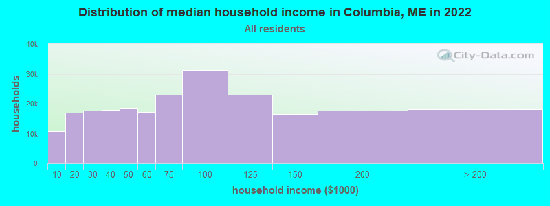
| Columbia: | $57,238 |
| ME: | $69,543 |
Estimated per capita income in 2022: $32,812 (it was $14,537 in 2000)
Columbia town income, earnings, and wages data
Estimated median house or condo value in 2022: $148,592 (it was $61,200 in 2000)
| Columbia: | $148,592 |
| ME: | $290,600 |
Mean prices in 2022: all housing units: $208,896; detached houses: $229,377; townhouses or other attached units: $190,242; in 2-unit structures: $139,050; in 3-to-4-unit structures: $456,045; in 5-or-more-unit structures: $413,457; mobile homes: $94,515; occupied boats, rvs, vans, etc.: $45,679
Detailed information about poverty and poor residents in Columbia, ME


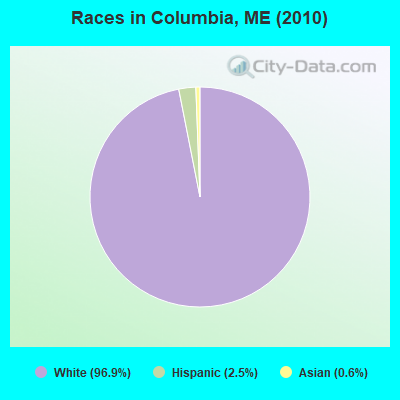
- 47196.9%White alone
- 122.5%Hispanic
- 30.6%Asian alone
Races in Columbia detailed stats: ancestries, foreign born residents, place of birth
According to our research of Maine and other state lists, there were 3 registered sex offenders living in Columbia, Maine as of May 23, 2024.
The ratio of all residents to sex offenders in Columbia is 162 to 1.
 Recent articles from our blog. Our writers, many of them Ph.D. graduates or candidates, create easy-to-read articles on a wide variety of topics.

 | Purchased a Franklin, Maine property (43 replies) |
| Days after minimum wage rises, Maine diner near nh cuts staff hours. (292 replies) |
| Whats Northern Maine like (42 replies) |
| Services in Washington County (31 replies) |
| Constitutional Carry and hunting with suppressors now law (68 replies) |
| LePage: "Bring back the guillotine" (90 replies) |
Latest news from Columbia, ME collected exclusively by city-data.com from local newspapers, TV, and radio stations
Columbia, ME City Guides:
Ancestries: English (36.8%), Irish (26.1%), United States (10.5%), French (7.0%), Swedish (5.7%), Italian (4.6%).
Current Local Time: EST time zone
Incorporated on 02/08/1796
Elevation: 100 feet
Land area: 36.0 square miles.
Population density: 14 people per square mile (very low).
| Columbia town: | 1.3% ($808) |
| Maine: | 1.5% ($1,417) |
Nearest city with pop. 50,000+: Portland, ME  (139.3 miles , pop. 64,249).
Nearest city with pop. 200,000+: Boston, MA (229.9 miles , pop. 589,141).
Nearest city with pop. 1,000,000+: Bronx, NY (404.5 miles , pop. 1,332,650).
Nearest cities:
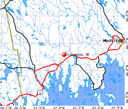
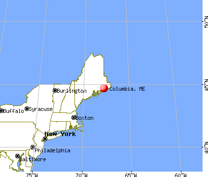
), Latitude: 44.65 N, Longitude: 67.82 W
Area code: 207

| Here: | 3.9% |
| Maine: | 3.4% |
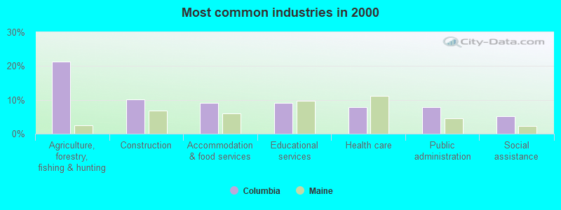
- Agriculture, forestry, fishing & hunting (21.4%)
- Construction (10.0%)
- Accommodation & food services (9.2%)
- Educational services (9.2%)
- Health care (7.9%)
- Public administration (7.9%)
- Social assistance (5.2%)
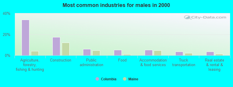
- Agriculture, forestry, fishing & hunting (33.9%)
- Construction (17.4%)
- Public administration (6.1%)
- Food (5.2%)
- Accommodation & food services (5.2%)
- Truck transportation (3.5%)
- Real estate & rental & leasing (3.5%)
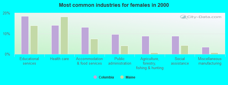
- Educational services (18.4%)
- Health care (14.0%)
- Accommodation & food services (13.2%)
- Public administration (9.6%)
- Agriculture, forestry, fishing & hunting (8.8%)
- Social assistance (8.8%)
- Miscellaneous manufacturing (3.5%)
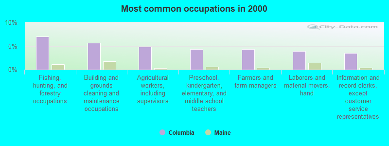
- Fishing, hunting, and forestry occupations (7.0%)
- Building and grounds cleaning and maintenance occupations (5.7%)
- Agricultural workers, including supervisors (4.8%)
- Preschool, kindergarten, elementary, and middle school teachers (4.4%)
- Farmers and farm managers (4.4%)
- Laborers and material movers, hand (3.9%)
- Information and record clerks, except customer service representatives (3.5%)

- Fishing, hunting, and forestry occupations (12.2%)
- Agricultural workers, including supervisors (9.6%)
- Farmers and farm managers (6.1%)
- Law enforcement workers, including supervisors (6.1%)
- Driver/sales workers and truck drivers (6.1%)
- Other management occupations, except farmers and farm managers (5.2%)
- Other sales and related occupations, including supervisors (4.3%)
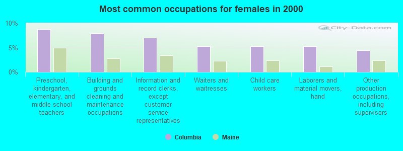
- Preschool, kindergarten, elementary, and middle school teachers (8.8%)
- Building and grounds cleaning and maintenance occupations (7.9%)
- Information and record clerks, except customer service representatives (7.0%)
- Waiters and waitresses (5.3%)
- Child care workers (5.3%)
- Laborers and material movers, hand (5.3%)
- Other production occupations, including supervisors (4.4%)
Average climate in Columbia, Maine
Based on data reported by over 4,000 weather stations


(lower is better)
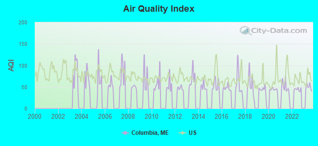
Air Quality Index (AQI) level in 2023 was 50.1. This is significantly better than average.
| City: | 50.1 |
| U.S.: | 72.6 |
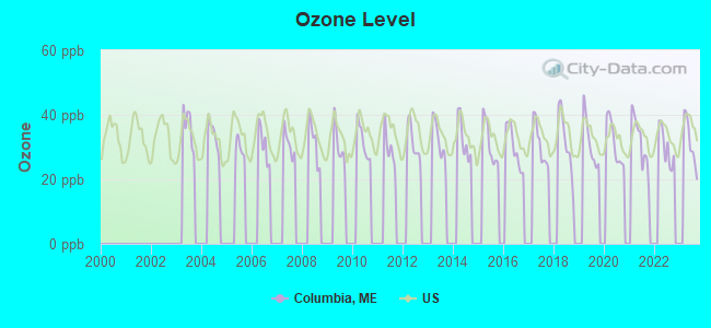
Ozone [ppb] level in 2023 was 31.5. This is about average. Closest monitor was 13.5 miles away from the city center.
| City: | 31.5 |
| U.S.: | 33.3 |
Earthquake activity:
Columbia-area historical earthquake activity is significantly above Maine state average. It is 82% smaller than the overall U.S. average.On 10/16/2012 at 23:12:25, a magnitude 4.7 (4.7 ML, Depth: 10.0 mi, Class: Light, Intensity: IV - V) earthquake occurred 158.5 miles away from the city center
On 4/20/2002 at 10:50:47, a magnitude 5.3 (5.3 ML, Depth: 3.0 mi, Class: Moderate, Intensity: VI - VII) earthquake occurred 289.5 miles away from Columbia center
On 4/20/2002 at 10:50:47, a magnitude 5.2 (5.2 MB, 4.2 MS, 5.2 MW, 5.0 MW) earthquake occurred 290.6 miles away from the city center
On 1/19/1982 at 00:14:42, a magnitude 4.7 (4.5 MB, 4.7 MD, 4.5 LG) earthquake occurred 203.9 miles away from the city center
On 10/7/1983 at 10:18:46, a magnitude 5.3 (5.1 MB, 5.3 LG, 5.1 ML) earthquake occurred 326.2 miles away from Columbia center
On 10/3/2006 at 00:07:38, a magnitude 3.7 (3.7 MD, Depth: 6.2 mi, Class: Light, Intensity: II - III) earthquake occurred 25.5 miles away from Columbia center
Magnitude types: regional Lg-wave magnitude (LG), body-wave magnitude (MB), duration magnitude (MD), local magnitude (ML), surface-wave magnitude (MS), moment magnitude (MW)
Natural disasters:
The number of natural disasters in Washington County (20) is greater than the US average (15).Major Disasters (Presidential) Declared: 14
Emergencies Declared: 6
Causes of natural disasters: Floods: 11, Storms: 10, Snows: 5, Winds: 2, Winter Storms: 2, Blizzard: 1, Heavy Rain: 1, Hurricane: 1, Ice Storm: 1, Landslide: 1, Snowfall: 1, Other: 2 (Note: some incidents may be assigned to more than one category).

Colleges/universities with over 2000 students nearest to Columbia:
- University of Maine (about 46 miles; Orono, ME; Full-time enrollment: 8,931)
- Husson University (about 50 miles; Bangor, ME; FT enrollment: 2,421)
- University of Maine at Augusta (about 100 miles; Augusta, ME; FT enrollment: 3,204)
- University of Maine at Farmington (about 115 miles; Farmington, ME; FT enrollment: 2,036)
- Southern Maine Community College (about 139 miles; South Portland, ME; FT enrollment: 4,666)
- University of Southern Maine (about 140 miles; Portland, ME; FT enrollment: 6,647)
- Saint Joseph's College of Maine (about 144 miles; Standish, ME; FT enrollment: 2,010)
Points of interest:
Notable locations in Columbia: Columbia Volunteer Fire Department (A), Pleasant River Ambulance (B). Display/hide their locations on the map
Church in Columbia: Little River Church (A). Display/hide its location on the map
Cemeteries: Mailey Hill Cemetery (1), Columbia Cemetery (2). Display/hide their locations on the map
Lakes, reservoirs, and swamps: Coffin Brook Pond (A), Myers Ponds (B), Schoodic Lake (C), Silica Ponds (D), Pigeon Hill Heath (E). Display/hide their locations on the map
Streams, rivers, and creeks: Western Little River (A), Trout Brook (B), Bells Brook (C), Dorr Brook (D), Flanders Little Brook (E), Great Marsh Stream (F), Hay Branch (G), Heath Brook (H), Mud Hole Brook (I). Display/hide their locations on the map
| This town: | 2.5 people |
| Maine: | 2.3 people |
| This town: | 62.1% |
| Whole state: | 62.9% |
| This town: | 13.1% |
| Whole state: | 9.4% |
Likely homosexual households (counted as self-reported same-sex unmarried-partner households)
- Lesbian couples: 0.0% of all households
- Gay men: 0.5% of all households
| This town: | 21.8% |
| Whole state: | 10.9% |
| This town: | 5.1% |
| Whole state: | 4.1% |
Banks with branches in Columbia (2011 data):
- Machias Savings Bank: Columbia Branch at 357 Us Highway 1, branch established on 1986/01/27. Info updated 2008/08/20: Bank assets: $933.5 mil, Deposits: $794.5 mil, headquarters in Machias, ME, positive income, Commercial Lending Specialization, 13 total offices, Holding Company: Machias Bancorp, Mhc
For population 15 years and over in Columbia:
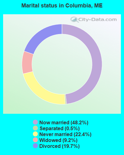
- Never married: 22.4%
- Now married: 48.2%
- Separated: 0.5%
- Widowed: 9.2%
- Divorced: 19.7%
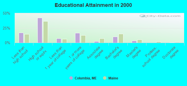
For population 25 years and over in Columbia:
- High school or higher: 82.8%
- Bachelor's degree or higher: 14.5%
- Graduate or professional degree: 4.3%
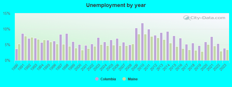
- Unemployed: 8.4%
- Mean travel time to work (commute): 22.2 minutes
| Here: | 9.5 |
| Maine average: | 11.2 |
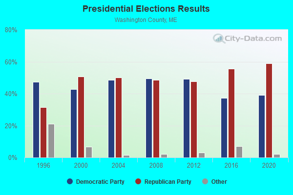

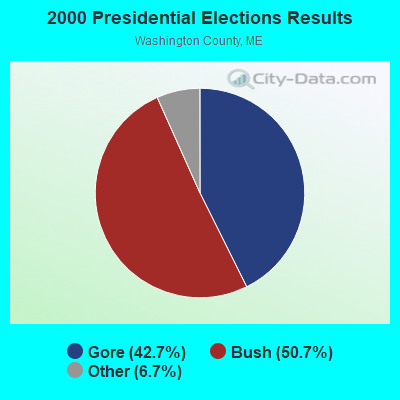
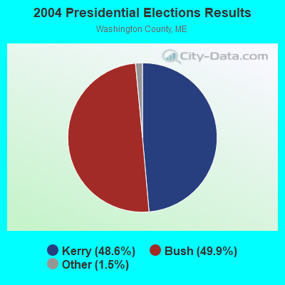

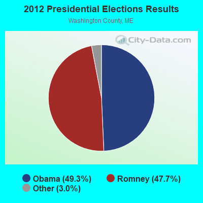
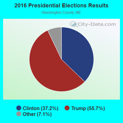
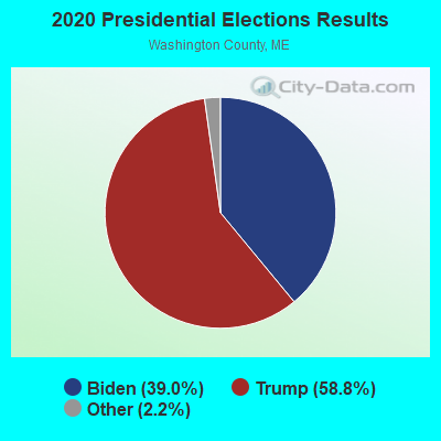
Graphs represent county-level data. Detailed 2008 Election Results
Religion statistics for Columbia, ME (based on Washington County data)
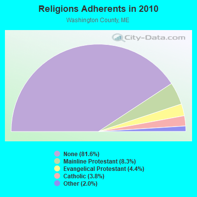
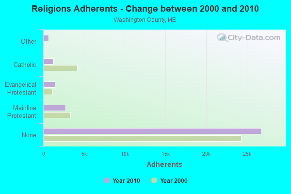
| Religion | Adherents | Congregations |
|---|---|---|
| Mainline Protestant | 2,731 | 37 |
| Evangelical Protestant | 1,442 | 31 |
| Catholic | 1,238 | 10 |
| Other | 648 | 13 |
| None | 26,797 | - |
Food Environment Statistics:
| This county: | 4.89 / 10,000 pop. |
| Maine: | 2.80 / 10,000 pop. |
| This county: | 1.22 / 10,000 pop. |
| State: | 2.20 / 10,000 pop. |
| Washington County: | 9.78 / 10,000 pop. |
| State: | 5.75 / 10,000 pop. |
| This county: | 11.31 / 10,000 pop. |
| Maine: | 11.02 / 10,000 pop. |
| This county: | 9.4% |
| Maine: | 8.2% |
| This county: | 28.3% |
| Maine: | 25.0% |
Strongest AM radio stations in Columbia:
- WZON (620 AM; 5 kW; BANGOR, ME; Owner: THE ZONE CORPORATION)
- WDEA (1370 AM; 5 kW; ELLSWORTH, ME; Owner: CUMULUS LICENSING CORP.)
- WABI (910 AM; 5 kW; BANGOR, ME; Owner: CLEAR CHANNEL BROADCASTING LICENSES, INC.)
- WRKO (680 AM; 50 kW; BOSTON, MA; Owner: ENTERCOM BOSTON LICENSE, LLC)
- WSKW (1160 AM; 10 kW; SKOWHEGAN, ME; Owner: MOUNTAIN WIRELESS, INCORPORATED)
- WEEI (850 AM; 50 kW; BOSTON, MA; Owner: ENTERCOM BOSTON LICENSE, LLC)
- WBZ (1030 AM; 50 kW; BOSTON, MA; Owner: INFINITY BROADCASTING OPERATIONS, INC.)
- WCRN (830 AM; 50 kW; WORCESTER, MA; Owner: CARTER BROADCASTING CORPORATION)
- WNNZ (640 AM; 50 kW; WESTFIELD, MA; Owner: CLEAR CHANNEL BROADCASTING LICENSES, INC.)
- WALE (990 AM; 50 kW; GREENVILLE, RI; Owner: NORTH AMERICAN BROADCASTING CO., INC.)
- WKOX (1200 AM; 50 kW; FRAMINGHAM, MA; Owner: CAPSTAR TX LIMITED PARTNERSHIP)
- WTME (780 AM; 10 kW; RUMFORD, ME; Owner: MOUNTAIN VALLEY BROADCASTING, INC.)
- WWZN (1510 AM; 50 kW; BOSTON, MA; Owner: ROSE CITY RADIO CORPORATION)
Strongest FM radio stations in Columbia:
- WNSX (97.7 FM; WINTER HARBOR, ME; Owner: CLEAR CHANNEL BROADCASTING LICENSES, INC.)
- WBQI (107.7 FM; BAR HARBOR, ME; Owner: MARINER BROADCASTING, L.P.)
- WHCF (88.5 FM; BANGOR, ME; Owner: BANGOR BAPTIST CHURCH)
- WWMJ (95.7 FM; ELLSWORTH, ME; Owner: CUMULUS LICENSING CORP.)
- WVOM (103.9 FM; HOWLAND, ME; Owner: CLEAR CHANNEL BROADCASTING LICENSES, INC.)
- WMEH (90.9 FM; BANGOR, ME; Owner: MAINE PUBLIC BROADCASTING CORPORATION)
- WLKE (99.1 FM; BAR HARBOR, ME; Owner: CLEAR CHANNEL BROADCASTING LICENSES, INC.)
- WERU-FM (89.9 FM; BLUE HILL, ME; Owner: SALT POND COMMUNITY B/C COMPANY)
- WEZQ (92.9 FM; BANGOR, ME; Owner: CUMULUS LICENSING CORP.)
- WALZ-FM (95.3 FM; MACHIAS, ME; Owner: WILLIAM MCVICAR & ROGER HOLST, GEN. PARTNERSHIP)
- National Bridge Inventory (NBI) Statistics
- 4Number of bridges
- 20ft / 6.2mTotal length
- 389Total average daily traffic
- 18Total average daily truck traffic
- 622Total future (year 2036) average daily traffic
FCC Registered Broadcast Land Mobile Towers:
2- Columbia Fire Station (Lat: 44.691194 Lon: -67.775833), Call Sign: KNAI241,
Assigned Frequencies: 154.995 MHz, Grant Date: 01/04/2011, Expiration Date: 03/14/2021, Cancellation Date: 05/15/2021, Registrant: Pct Communications, 483 North St, Calais, ME 04619, Phone: (207) 454-2174, Fax: (207) 454-7050, Email:
- Fire Station (Lat: 44.691194 Lon: -67.775833), Call Sign: WGI712,
Assigned Frequencies: 453.325 MHz, Grant Date: 01/04/2011, Expiration Date: 03/14/2021, Cancellation Date: 05/15/2021, Registrant: Pct Communications, 483 North St, Calais, ME 04619, Phone: (207) 454-2174, Fax: (207) 454-7050, Email:
FCC Registered Microwave Towers:
1- QEB-RCAG, .35 M Ne Of Pea Ridge And Epping Rd Intersection (Lat: 44.676111 Lon: -67.791306), Type: Gtower, Structure height: 42.7 m, Call Sign: WQZC921,
Assigned Frequencies: 6615.00 MHz, 6615.00 MHz, 6615.00 MHz, 6615.00 MHz, 6615.00 MHz, 6615.00 MHz, 6615.00 MHz, 6615.00 MHz, Grant Date: 04/08/2017, Expiration Date: 04/08/2027, Certifier: Nilsa Brown, Registrant: L3harris Technologies, Inc., 1025 West Nasa Boulevard, Ms F-11 A, Melbourne, FL 32919, Phone: (321) 309-2452, Fax: (321) 726-3336, Email:
FCC Registered Amateur Radio Licenses:
4- Call Sign: N1JBI, Licensee ID: L00334872, Grant Date: 03/12/2001, Expiration Date: 05/21/2011, Cancellation Date: 05/22/2013, Registrant: James L Corliss, Rfd 1 Box 43b, Columbia, ME 04623
- Call Sign: N1XRW, Licensee ID: L00428158, Grant Date: 05/28/2016, Expiration Date: 07/30/2026, Certifier: Richard W Miller, Registrant: Richard W Miller, 55 Saco Rd, Columbia, ME 04623
- Call Sign: N1ZDK, Grant Date: 05/02/1997, Expiration Date: 05/02/2007, Cancellation Date: 05/05/2009, Registrant: Paul J Favolise Jr, Rr 1 Box 40 A Farnsworth Rd, Columbia, ME 04623
- Call Sign: KC1BHT, Licensee ID: L01845872, Grant Date: 02/27/2014, Expiration Date: 02/27/2024, Certifier: Patricia A Favolise, Registrant: Patricia A Favolise, 115 Farnsworth Rd, Columbia, ME 04623
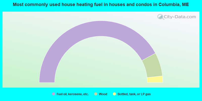
- 84.2%Fuel oil, kerosene, etc.
- 12.3%Wood
- 3.4%Bottled, tank, or LP gas
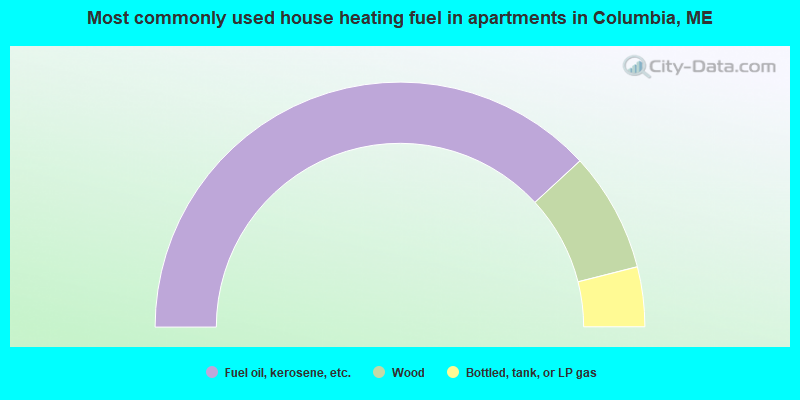
- 76.3%Fuel oil, kerosene, etc.
- 15.8%Wood
- 7.9%Bottled, tank, or LP gas
Columbia compared to Maine state average:
- Median house value below state average.
- Black race population percentage significantly below state average.
- Foreign-born population percentage significantly below state average.
- Length of stay since moving in significantly above state average.
- Number of rooms per house significantly below state average.
- House age significantly below state average.
- Percentage of population with a bachelor's degree or higher below state average.