Campton, New Hampshire

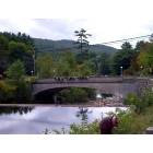
Campton: Beautiful Campton Falls Dam, NH
Campton: Campton Falls Dam in Autumn
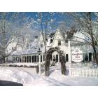
Campton: Christmas Inn Walk

Campton: Campton Bog
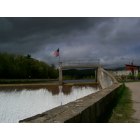
Campton: Campton Damn
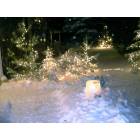
Campton: Fire and Ice
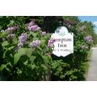
Campton: Lilacs in June
- add
your
Submit your own pictures of this town and show them to the world
- OSM Map
- Google Map
- MSN Map
Population change since 2000: +22.6%
| Males: 1,666 | |
| Females: 1,667 |
| Median resident age: | 44.1 years |
| New Hampshire median age: | 43.9 years |
Zip codes: 03223.
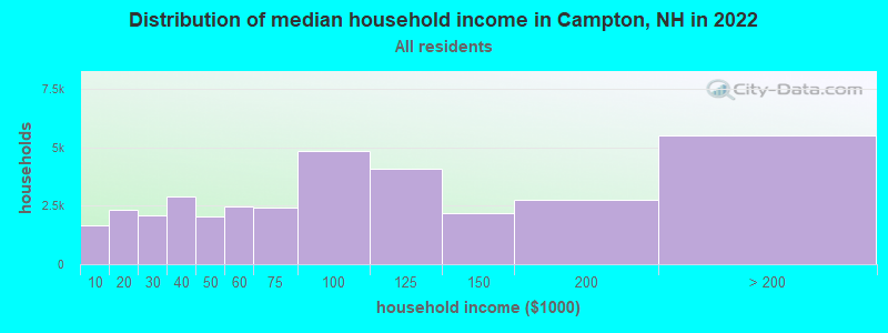
| Campton: | $76,670 |
| NH: | $89,992 |
Estimated per capita income in 2022: $45,910 (it was $20,189 in 2000)
Campton town income, earnings, and wages data
Estimated median house or condo value in 2022: $303,322 (it was $94,900 in 2000)
| Campton: | $303,322 |
| NH: | $384,700 |
Mean prices in 2022: all housing units: $486,096; detached houses: $533,852; townhouses or other attached units: $375,744; in 2-unit structures: $230,260; in 3-to-4-unit structures: $242,363; in 5-or-more-unit structures: $588,257; mobile homes: $127,035
Detailed information about poverty and poor residents in Campton, NH


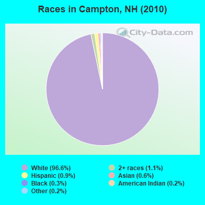
- 3,22196.6%White alone
- 361.1%Two or more races
- 310.9%Hispanic
- 200.6%Asian alone
- 90.3%Black alone
- 80.2%American Indian alone
- 80.2%Other race alone
Races in Campton detailed stats: ancestries, foreign born residents, place of birth
According to our research of New Hampshire and other state lists, there were 9 registered sex offenders living in Campton, New Hampshire as of May 23, 2024.
The ratio of all residents to sex offenders in Campton is 370 to 1.
Type |
2009 |
2010 |
2011 |
2012 |
2013 |
2014 |
2015 |
2016 |
2017 |
2018 |
2019 |
2020 |
2021 |
2022 |
|---|---|---|---|---|---|---|---|---|---|---|---|---|---|---|
| Murders (per 100,000) | 0 (0.0) | 0 (0.0) | 0 (0.0) | 0 (0.0) | 0 (0.0) | 0 (0.0) | 0 (0.0) | 0 (0.0) | 0 (0.0) | 0 (0.0) | 0 (0.0) | 0 (0.0) | 0 (0.0) | 0 (0.0) |
| Rapes (per 100,000) | 0 (0.0) | 2 (60.0) | 5 (149.8) | 0 (0.0) | 6 (181.7) | 1 (30.2) | 1 (30.1) | 7 (212.1) | 6 (182.6) | 4 (121.9) | 4 (121.0) | 6 (182.0) | 3 (90.0) | 7 (204.8) |
| Robberies (per 100,000) | 2 (65.8) | 0 (0.0) | 1 (30.0) | 0 (0.0) | 1 (30.3) | 1 (30.2) | 0 (0.0) | 0 (0.0) | 1 (30.4) | 1 (30.5) | 0 (0.0) | 0 (0.0) | 1 (30.0) | 0 (0.0) |
| Assaults (per 100,000) | 3 (98.7) | 5 (150.0) | 4 (119.9) | 2 (60.0) | 9 (272.6) | 2 (60.4) | 6 (180.3) | 2 (60.6) | 4 (121.7) | 9 (274.3) | 1 (30.3) | 8 (242.6) | 3 (90.0) | 4 (117.0) |
| Burglaries (per 100,000) | 17 (559.4) | 15 (450.0) | 13 (389.6) | 25 (750.5) | 16 (484.6) | 19 (573.8) | 16 (480.9) | 7 (212.1) | 8 (243.5) | 8 (243.8) | 2 (60.5) | 8 (242.6) | 4 (119.9) | 2 (58.5) |
| Thefts (per 100,000) | 50 (1,645) | 51 (1,530) | 48 (1,438) | 59 (1,771) | 48 (1,454) | 28 (845.7) | 24 (721.4) | 33 (1,000) | 40 (1,217) | 49 (1,493) | 31 (938.0) | 27 (818.9) | 23 (689.7) | 28 (819.2) |
| Auto thefts (per 100,000) | 4 (131.6) | 1 (30.0) | 1 (30.0) | 3 (90.1) | 4 (121.1) | 1 (30.2) | 1 (30.1) | 2 (60.6) | 3 (91.3) | 1 (30.5) | 2 (60.5) | 3 (91.0) | 2 (60.0) | 2 (58.5) |
| Arson (per 100,000) | 2 (65.8) | 1 (30.0) | 1 (30.0) | 2 (60.0) | 0 (0.0) | 0 (0.0) | 0 (0.0) | 0 (0.0) | 0 (0.0) | 3 (91.4) | 0 (0.0) | 0 (0.0) | 0 (0.0) | 1 (29.3) |
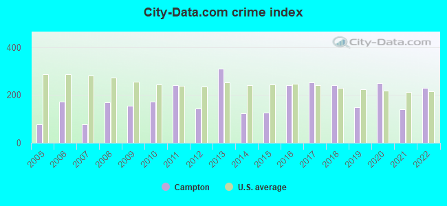
| City-Data.com crime index | 155.0 | 173.1 | 240.0 | 142.6 | 310.7 | 121.7 | 125.0 | 241.5 | 252.6 | 240.8 | 149.5 | 251.1 | 139.7 | 228.8 |
The City-Data.com crime index weighs serious crimes and violent crimes more heavily. Higher means more crime, U.S. average is 246.1. It adjusts for the number of visitors and daily workers commuting into cities.
Crime rate in Campton detailed stats: murders, rapes, robberies, assaults, burglaries, thefts, arson
Full-time law enforcement employees in 2021, including police officers: 7 (5 officers - 5 male; 0 female).
| Officers per 1,000 residents here: | 1.50 |
| New Hampshire average: | 2.14 |
 Recent articles from our blog. Our writers, many of them Ph.D. graduates or candidates, create easy-to-read articles on a wide variety of topics.
Ancestries: English (20.1%), Irish (14.6%), French (12.1%), United States (10.7%), German (8.9%), Scottish (7.1%).
Current Local Time: EST time zone
Incorporated in 1761
Land area: 51.9 square miles.
Population density: 64 people per square mile (very low).
63 residents are foreign born (1.5% Europe, 0.4% Asia, 0.3% North America).
| This town: | 2.3% |
| New Hampshire: | 4.4% |
| Campton town: | 2.5% ($2,391) |
| New Hampshire: | 2.3% ($2,946) |
Nearest city with pop. 50,000+: Manchester, NH  (59.8 miles , pop. 107,006).
Nearest city with pop. 200,000+: Boston, MA (108.7 miles , pop. 589,141).
Nearest city with pop. 1,000,000+: Bronx, NY (236.1 miles , pop. 1,332,650).
Nearest cities:
), Latitude: 43.84 N, Longitude: 71.65 W
Area code: 603
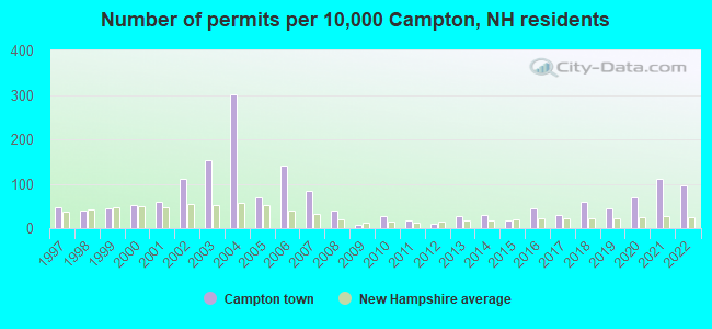
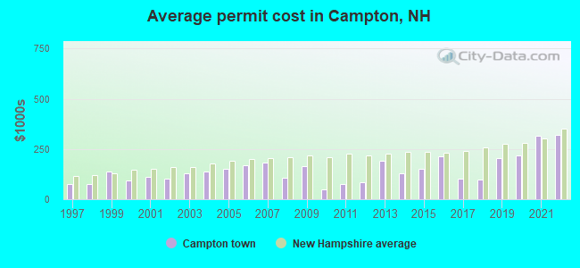
Single-family new house construction building permits:
- 2022: 26 buildings, average cost: $322,000
- 2021: 30 buildings, average cost: $315,700
- 2020: 19 buildings, average cost: $215,500
- 2019: 12 buildings, average cost: $203,800
- 2018: 16 buildings, average cost: $100,000
- 2017: 8 buildings, average cost: $103,100
- 2016: 12 buildings, average cost: $214,700
- 2015: 5 buildings, average cost: $150,400
- 2014: 8 buildings, average cost: $130,800
- 2013: 7 buildings, average cost: $193,300
- 2012: 3 buildings, average cost: $83,300
- 2011: 5 buildings, average cost: $75,000
- 2010: 7 buildings, average cost: $50,000
- 2009: 2 buildings, average cost: $162,500
- 2008: 11 buildings, average cost: $106,800
- 2007: 23 buildings, average cost: $181,200
- 2006: 38 buildings, average cost: $171,000
- 2005: 19 buildings, average cost: $150,200
- 2004: 82 buildings, average cost: $138,800
- 2003: 42 buildings, average cost: $126,600
- 2002: 30 buildings, average cost: $101,400
- 2001: 16 buildings, average cost: $111,600
- 2000: 14 buildings, average cost: $95,200
- 1999: 12 buildings, average cost: $137,600
- 1998: 11 buildings, average cost: $73,600
- 1997: 13 buildings, average cost: $75,700
| Here: | 2.0% |
| New Hampshire: | 2.5% |
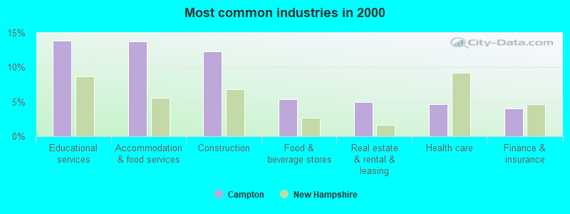
- Educational services (13.9%)
- Accommodation & food services (13.8%)
- Construction (12.3%)
- Food & beverage stores (5.3%)
- Real estate & rental & leasing (5.0%)
- Health care (4.7%)
- Finance & insurance (4.0%)
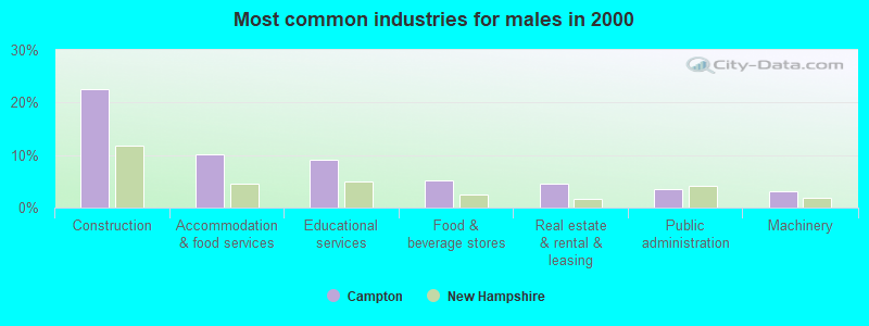
- Construction (22.5%)
- Accommodation & food services (10.2%)
- Educational services (9.1%)
- Food & beverage stores (5.2%)
- Real estate & rental & leasing (4.6%)
- Public administration (3.4%)
- Machinery (3.2%)
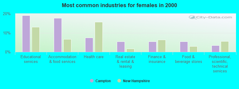
- Educational services (19.1%)
- Accommodation & food services (17.7%)
- Health care (7.4%)
- Real estate & rental & leasing (5.4%)
- Finance & insurance (5.4%)
- Food & beverage stores (5.4%)
- Professional, scientific, technical services (3.5%)
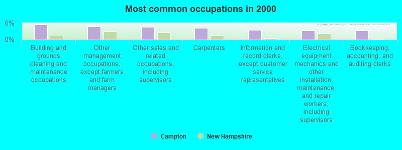
- Building and grounds cleaning and maintenance occupations (5.4%)
- Other management occupations, except farmers and farm managers (4.7%)
- Other sales and related occupations, including supervisors (4.5%)
- Carpenters (4.2%)
- Information and record clerks, except customer service representatives (3.4%)
- Electrical equipment mechanics and other installation, maintenance, and repair workers, including supervisors (3.3%)
- Bookkeeping, accounting, and auditing clerks (3.2%)
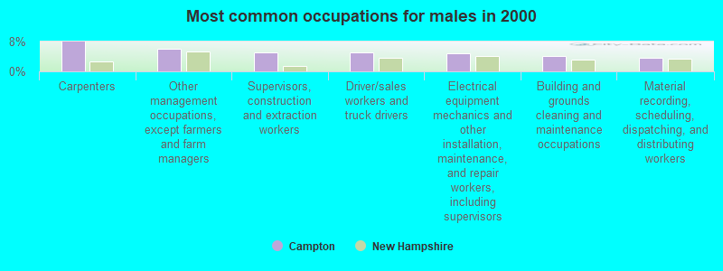
- Carpenters (8.0%)
- Other management occupations, except farmers and farm managers (6.1%)
- Supervisors, construction and extraction workers (5.1%)
- Driver/sales workers and truck drivers (5.1%)
- Electrical equipment mechanics and other installation, maintenance, and repair workers, including supervisors (4.9%)
- Building and grounds cleaning and maintenance occupations (4.2%)
- Material recording, scheduling, dispatching, and distributing workers (3.6%)
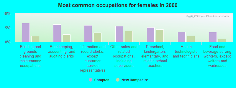
- Building and grounds cleaning and maintenance occupations (6.7%)
- Bookkeeping, accounting, and auditing clerks (6.1%)
- Information and record clerks, except customer service representatives (5.9%)
- Other sales and related occupations, including supervisors (5.6%)
- Preschool, kindergarten, elementary, and middle school teachers (5.2%)
- Health technologists and technicians (3.6%)
- Food and beverage serving workers, except waiters and waitresses (3.5%)
Average climate in Campton, New Hampshire
Based on data reported by over 4,000 weather stations


(lower is better)
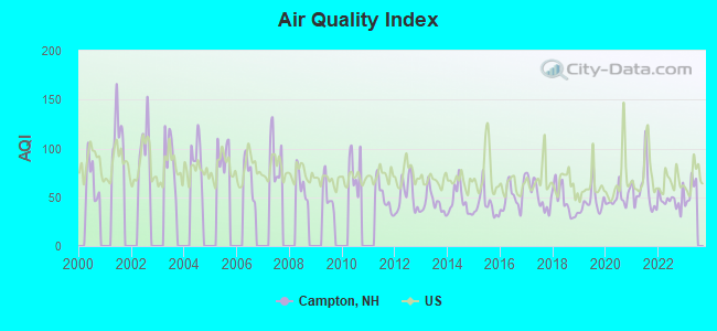
Air Quality Index (AQI) level in 2022 was 46.9. This is significantly better than average.
| City: | 46.9 |
| U.S.: | 72.6 |
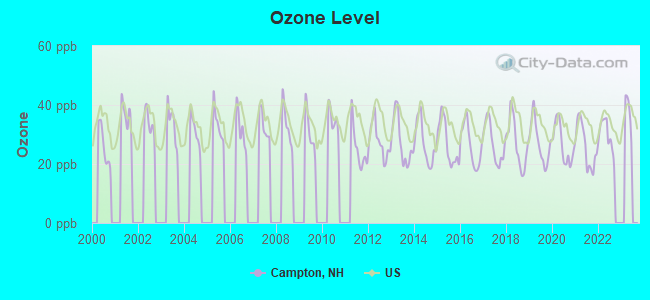
Ozone [ppb] level in 2022 was 29.7. This is about average. Closest monitor was 6.7 miles away from the city center.
| City: | 29.7 |
| U.S.: | 33.3 |
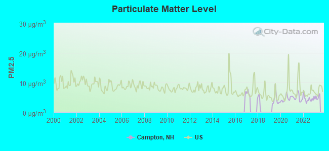
Particulate Matter (PM2.5) [µg/m3] level in 2022 was 4.52. This is significantly better than average. Closest monitor was 6.0 miles away from the city center.
| City: | 4.52 |
| U.S.: | 8.11 |
Tornado activity:
Campton-area historical tornado activity is below New Hampshire state average. It is 71% smaller than the overall U.S. average.
On 8/11/1966, a category F2 (max. wind speeds 113-157 mph) tornado 21.2 miles away from the Campton town center caused between $50,000 and $500,000 in damages.
On 5/11/1973, a category F2 tornado 23.9 miles away from the town center .
Earthquake activity:
Campton-area historical earthquake activity is significantly above New Hampshire state average. It is 72% smaller than the overall U.S. average.On 4/20/2002 at 10:50:47, a magnitude 5.3 (5.3 ML, Depth: 3.0 mi, Class: Moderate, Intensity: VI - VII) earthquake occurred 111.7 miles away from the city center
On 4/20/2002 at 10:50:47, a magnitude 5.2 (5.2 MB, 4.2 MS, 5.2 MW, 5.0 MW) earthquake occurred 112.0 miles away from the city center
On 10/7/1983 at 10:18:46, a magnitude 5.3 (5.1 MB, 5.3 LG, 5.1 ML) earthquake occurred 134.4 miles away from the city center
On 1/19/1982 at 00:14:42, a magnitude 4.7 (4.5 MB, 4.7 MD, 4.5 LG, Class: Light, Intensity: IV - V) earthquake occurred 23.6 miles away from Campton center
On 10/16/2012 at 23:12:25, a magnitude 4.7 (4.7 ML, Depth: 10.0 mi) earthquake occurred 52.4 miles away from Campton center
On 8/21/1996 at 07:54:14, a magnitude 3.8 (3.8 LG, 3.6 LG, Depth: 6.2 mi, Class: Light, Intensity: II - III) earthquake occurred 28.1 miles away from the city center
Magnitude types: regional Lg-wave magnitude (LG), body-wave magnitude (MB), duration magnitude (MD), local magnitude (ML), surface-wave magnitude (MS), moment magnitude (MW)
Natural disasters:
The number of natural disasters in Grafton County (32) is a lot greater than the US average (15).Major Disasters (Presidential) Declared: 20
Emergencies Declared: 9
Causes of natural disasters: Floods: 16, Storms: 16, Hurricanes: 3, Snows: 3, Winter Storms: 3, Tropical Storms: 2, Blizzard: 1, Heavy Rain: 1, Ice Storm: 1, Landslide: 1, Snowfall: 1, Snowstorm: 1, Wind: 1, Other: 1 (Note: some incidents may be assigned to more than one category).
Colleges/universities with over 2000 students nearest to Campton:
- Plymouth State University (about 7 miles; Plymouth, NH; Full-time enrollment: 4,838)
- Dartmouth College (about 34 miles; Hanover, NH; FT enrollment: 6,030)
- NHTI-Concord's Community College (about 43 miles; Concord, NH; FT enrollment: 2,865)
- Norwich University (about 55 miles; Northfield, VT; FT enrollment: 4,221)
- Southern New Hampshire University (about 57 miles; Manchester, NH; FT enrollment: 16,552)
- Saint Joseph's College of Maine (about 59 miles; Standish, ME; FT enrollment: 2,010)
- Saint Anselm College (about 60 miles; Manchester, NH; FT enrollment: 2,059)
Private high school in Campton:
Public elementary/middle school in Campton:
- CAMPTON ELEMENTARY SCHOOL (Students: 349, Location: 1110 NH RTE. 175, Grades: PK-8)
Points of interest:
Notable locations in Campton: Beebe River Railroad Station (A), Campton - Thornton Fire Department Station 3 (B), Campton - Thornton Fire Department Station 1 Headquarters (C). Display/hide their locations on the map
Church in Campton: Campton Church (A). Display/hide its location on the map
Cemeteries: Campton Hollow Cemetery (1), Blair Cemetery (2). Display/hide their locations on the map
Lakes, reservoirs, and swamps: Bog Pond (A), Campton Bog Pond (B), Chickenboro Brook Reservoir (C), Milo Lake (D), Little Perch Pond (E), Moosilauke Pond (F), Perch Pond (G), Campton Pond (H). Display/hide their locations on the map
Streams, rivers, and creeks: Winter Brook (A), Durgin Brook (B), Mad River (C), Ryan Brook (D), Bog Brook (E), Beebe River (F), Avery Brook (G), Palmer Brook (H), Spencer Brook (I). Display/hide their locations on the map
Park in Campton: Rowbartwood Marsh Wildlife Management Area (1). Display/hide its location on the map
Hotels: Armont Inn (311 Ellsworth Hill Rd) (1), Days Inn Campton NH (1513 US Route 3) (2), Sunny Grange B & B (1354 Nh Rt 175) (3), Black Bear Lodge (3 Village Road) (4). Display/hide their approximate locations on the map
Birthplace of: Henry W. Blair - Union Army officer.
Drinking water stations with addresses in Campton and their reported violations in the past:
CAMPTON VILLAGE PCT (Population served: 595, Groundwater):Past monitoring violations:MOUNTAIN RIVER CONDOS EAST (Population served: 200, Groundwater):
- Follow-up Or Routine LCR Tap M/R - In OCT-01-2005, Contaminant: Lead and Copper Rule. Follow-up actions: St Public Notif requested (JAN-31-2006), St Violation/Reminder Notice (JAN-31-2006), St Compliance achieved (MAR-07-2006), St Public Notif received (MAR-07-2006)
Past monitoring violations:HIGHLAND LINKS COLONY (Population served: 88, Groundwater):
- Lead Consumer Notice - In JUL-01-2012, Contaminant: Lead and Copper Rule. Follow-up actions: St Violation/Reminder Notice (JUL-10-2012), St Compliance achieved (AUG-03-2012)
Past health violations:SUNSET GRILL (Population served: 85, Groundwater):Past monitoring violations:
- MCL, Monthly (TCR) - In JUN-2005, Contaminant: Coliform. Follow-up actions: St Public Notif requested (JUL-08-2005), St Violation/Reminder Notice (JUL-08-2005), St Public Notif received (JUL-15-2005), St Compliance achieved (JAN-06-2006)
- Failure To Address Deficiency - In SEP-15-2012, Contaminant: GROUNDWATER RULE. Follow-up actions: St Compliance achieved (JUL-10-2012), St Public Notif requested (JUN-07-2013), St Violation/Reminder Notice (JUN-07-2013), St Public Notif received (JUL-05-2013)
Past monitoring violations:NORTHPOINTE WATER (Population served: 83, Groundwater):
- 4 routine major monitoring violations
Past health violations:TONYS ITALIAN GRILLE AND PUB (Population served: 83, Groundwater):Past monitoring violations:
- MCL, Monthly (TCR) - In JAN-2012, Contaminant: Coliform. Follow-up actions: St Public Notif requested (JAN-10-2012), St Violation/Reminder Notice (JAN-10-2012), St Public Notif received (JAN-30-2012), St Formal NOV issued (MAR-09-2012), St Compliance achieved (JUL-19-2012)
- MCL, Monthly (TCR) - In AUG-2011, Contaminant: Coliform. Follow-up actions: St Public Notif requested (AUG-31-2011), St Violation/Reminder Notice (AUG-31-2011), St Public Notif received (OCT-14-2011), St Formal NOV issued (MAR-09-2012), St Compliance achieved (JUL-19-2012)
- Public Education - In OCT-01-2008, Contaminant: Lead and Copper Rule. Follow-up actions: St Public Notif requested (NOV-21-2008), St Violation/Reminder Notice (NOV-21-2008), St Public Notif received (DEC-03-2008), St Compliance achieved (DEC-03-2008)
- MCL, Monthly (TCR) - In SEP-2008, Contaminant: Coliform. Follow-up actions: St Public Notif requested (SEP-22-2008), St Violation/Reminder Notice (SEP-22-2008), St Public Notif received (OCT-01-2008), St Compliance achieved (APR-27-2009)
- Public Education - In OCT-01-2007, Contaminant: Lead and Copper Rule. Follow-up actions: St Violation/Reminder Notice (MAY-15-2008), St Compliance achieved (MAY-20-2008)
- MCL, Monthly (TCR) - In SEP-2007, Contaminant: Coliform. Follow-up actions: St Public Notif requested (OCT-02-2007), St Violation/Reminder Notice (OCT-02-2007), St Public Notif received (OCT-17-2007), St Compliance achieved (APR-07-2008)
- 4 other older health violations
- Failure To Address Deficiency - In APR-06-2013, Contaminant: GROUNDWATER RULE. Follow-up actions: St Public Notif requested (APR-19-2013), St Formal NOV issued (APR-19-2013), St Compliance achieved (JUN-04-2013), St Public Notif received (JUN-12-2013)
- Monitoring, Source Water (GWR) - Between FEB-13-2013 and MAR-13-2013, Contaminant: E. COLI. Follow-up actions: St Public Notif requested (MAR-01-2013), St Violation/Reminder Notice (MAR-01-2013), St Compliance achieved (MAR-01-2013), St Public Notif received (MAR-07-2013)
- Monitoring, Repeat Major (TCR) - In SEP-2011, Contaminant: Coliform (TCR). Follow-up actions: St Public Notif requested (DEC-01-2011), St Violation/Reminder Notice (DEC-01-2011), St Compliance achieved (DEC-01-2011), St Public Notif received (DEC-13-2011)
- Water Quality Parameter M/R - In OCT-01-2008, Contaminant: Lead and Copper Rule. Follow-up actions: St Public Notif requested (NOV-21-2008), St Violation/Reminder Notice (NOV-21-2008), St Public Notif received (DEC-03-2008), St Compliance achieved (DEC-03-2008)
- One routine major monitoring violation
- One minor monitoring violation
Past health violations:BEEBE RIVER (Population served: 63, Groundwater):Past monitoring violations:
- MCL, Acute (TCR) - Between APR-2005 and JUN-2005, Contaminant: Coliform. Follow-up actions: St Public Notif requested (APR-07-2005), St Violation/Reminder Notice (APR-07-2005), St Public Notif received (APR-28-2005), St Compliance achieved (DEC-06-2005)
- 4 routine major monitoring violations
- One minor monitoring violation
Past health violations:MOUNTAIN RIVER CONDOS (Population served: 60, Groundwater):Past monitoring violations:
- Public Education - In JAN-01-2011, Contaminant: Lead and Copper Rule. Follow-up actions: St Public Notif requested (FEB-11-2011), St Violation/Reminder Notice (FEB-11-2011), St Public Notif received (MAR-08-2011), St Formal NOV issued (MAY-05-2011), St Compliance achieved (MAY-20-2011)
- MCL, Monthly (TCR) - In AUG-2009, Contaminant: Coliform. Follow-up actions: St Violation/Reminder Notice (AUG-28-2009), St Compliance achieved (FEB-16-2010)
- MCL, Monthly (TCR) - In DEC-2008, Contaminant: Coliform. Follow-up actions: St Violation/Reminder Notice (JAN-02-2009), St Compliance achieved (JUN-18-2009)
- OCCT/SOWT Study/Recommendation - In NOV-01-2008, Contaminant: Lead and Copper Rule. Follow-up actions: St Violation/Reminder Notice (MAY-04-2009), St Compliance achieved (JUN-29-2009)
- MCL, Monthly (TCR) - In SEP-2008, Contaminant: Coliform. Follow-up actions: St Violation/Reminder Notice (SEP-30-2008), St Compliance achieved (JUN-18-2009)
- MCL, Monthly (TCR) - In AUG-2008, Contaminant: Coliform. Follow-up actions: St Violation/Reminder Notice (AUG-18-2008), St Compliance achieved (JUN-18-2009)
- 2 other older health violations
- Failure To Address Deficiency - In SEP-22-2012, Contaminant: GROUNDWATER RULE. Follow-up actions: St Public Notif requested (OCT-22-2012), St Violation/Reminder Notice (OCT-22-2012), St Public Notif received (DEC-27-2012), St Compliance achieved (MAR-14-2013)
- Water Quality Parameter M/R - In JAN-01-2011, Contaminant: Lead and Copper Rule. Follow-up actions: St Public Notif requested (AUG-09-2011), St Violation/Reminder Notice (AUG-09-2011), St Compliance achieved (AUG-15-2011), St Public Notif received (DEC-13-2011)
- 22 regular monitoring violations
Past health violations:Past monitoring violations:
- MCL, Monthly (TCR) - In NOV-2011, Contaminant: Coliform. Follow-up actions: St Public Notif requested (DEC-01-2011), St Violation/Reminder Notice (DEC-01-2011), St Public Notif received (DEC-29-2011), St Compliance achieved (JUL-19-2012)
- MCL, Monthly (TCR) - In OCT-2011, Contaminant: Coliform. Follow-up actions: St Public Notif requested (NOV-23-2011), St Formal NOV issued (NOV-23-2011), St Public Notif received (DEC-29-2011), St Compliance achieved (JUL-19-2012)
- MCL, Monthly (TCR) - In SEP-2011, Contaminant: Coliform. Follow-up actions: St Public Notif requested (OCT-17-2011), St Violation/Reminder Notice (OCT-17-2011), St Public Notif received (OCT-19-2011), St Formal NOV issued (NOV-23-2011), St Compliance achieved (JUL-19-2012)
- MCL, Monthly (TCR) - In MAY-2009, Contaminant: Coliform. Follow-up actions: St Violation/Reminder Notice (JUN-15-2009), St Public Notif requested (JUN-15-2009), St Public Notif received (JUN-17-2009), St Compliance achieved (NOV-18-2009)
- Monitoring, Source Water (GWR) - Between DEC-01-2011 and JAN-01-2012, Contaminant: E. COLI. Follow-up actions: St Public Notif requested (DEC-23-2011), St Violation/Reminder Notice (DEC-23-2011), St Public Notif received (DEC-29-2011), St Compliance achieved (JAN-05-2012)
Drinking water stations with addresses in Campton that have no violations reported:
- RUSSELL POND CAMPGROUND (Population served: 400, Primary Water Source Type: Groundwater)
- WATERVILLE CAMPGROUND II (Population served: 100, Primary Water Source Type: Groundwater)
- WATERVILLE CAMPGROUND I (Population served: 100, Primary Water Source Type: Groundwater)
- BIRCH BEND (Population served: 28, Primary Water Source Type: Groundwater)
- SOUTH POND RECREATION AREA (Population served: 25, Primary Water Source Type: Groundwater)
| This town: | 2.4 people |
| New Hampshire: | 2.5 people |
| This town: | 67.5% |
| Whole state: | 66.3% |
| This town: | 8.0% |
| Whole state: | 8.3% |
Likely homosexual households (counted as self-reported same-sex unmarried-partner households)
- Lesbian couples: 0.6% of all households
- Gay men: 0.3% of all households
| This town: | 8.8% |
| Whole state: | 6.5% |
| This town: | 3.2% |
| Whole state: | 2.8% |
Banks with branches in Campton (2011 data):
- Community Guaranty Savings Bank: Campton Branch at 21 Tower Road, branch established on 2000/01/18. Info updated 2006/11/03: Bank assets: $106.7 mil, Deposits: $91.5 mil, headquarters in Plymouth, NH, positive income, Mortgage Lending Specialization, 2 total offices, Holding Company: Community Guaranty Corporation
- Northway Bank: Campton Branch at Route 49, branch established on 1975/04/07. Info updated 2006/04/17: Bank assets: $814.2 mil, Deposits: $619.0 mil, headquarters in Berlin, NH, positive income, Commercial Lending Specialization, 17 total offices, Holding Company: Northway Financial, Inc.
- Meredith Village Savings Bank: Campton Corners Branch at 25 Vintinner Road, branch established on 2004/06/26. Info updated 2009/03/03: Bank assets: $669.2 mil, Deposits: $513.6 mil, headquarters in Meredith, NH, positive income, Commercial Lending Specialization, 13 total offices
For population 15 years and over in Campton:
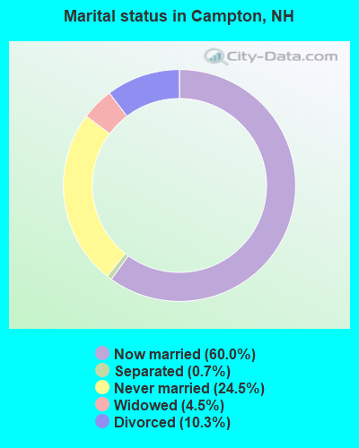
- Never married: 24.5%
- Now married: 60.0%
- Separated: 0.7%
- Widowed: 4.5%
- Divorced: 10.3%
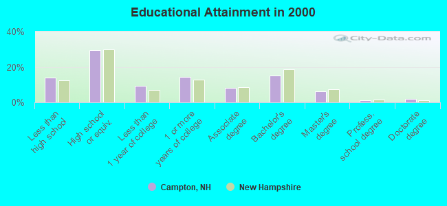
For population 25 years and over in Campton:
- High school or higher: 85.9%
- Bachelor's degree or higher: 24.7%
- Graduate or professional degree: 9.3%
- Unemployed: 2.8%
- Mean travel time to work (commute): 23.7 minutes
| Here: | 11.1 |
| New Hampshire average: | 10.9 |


Graphs represent county-level data. Detailed 2008 Election Results
Religion statistics for Campton, NH (based on Grafton County data)


| Religion | Adherents | Congregations |
|---|---|---|
| Catholic | 9,503 | 12 |
| Mainline Protestant | 7,832 | 57 |
| Evangelical Protestant | 1,494 | 29 |
| Other | 1,320 | 11 |
| None | 68,969 | - |
Food Environment Statistics:
| Grafton County: | 3.87 / 10,000 pop. |
| New Hampshire: | 2.14 / 10,000 pop. |
| Grafton County: | 0.23 / 10,000 pop. |
| New Hampshire: | 0.15 / 10,000 pop. |
| Grafton County: | 1.29 / 10,000 pop. |
| New Hampshire: | 1.78 / 10,000 pop. |
| Here: | 6.45 / 10,000 pop. |
| New Hampshire: | 4.02 / 10,000 pop. |
| Here: | 14.41 / 10,000 pop. |
| State: | 9.70 / 10,000 pop. |
| Grafton County: | 7.2% |
| State: | 7.6% |
| Grafton County: | 22.9% |
| New Hampshire: | 24.4% |
| Here: | 15.9% |
| New Hampshire: | 15.9% |
| Businesses in Campton, NH | ||||
| Name | Count | Name | Count | |
|---|---|---|---|---|
| Days Inn | 1 | U-Haul | 1 | |
| Dunkin Donuts | 1 | UPS | 1 | |
| FedEx | 1 | |||
Strongest AM radio stations in Campton:
- WPNH (1300 AM; 5 kW; PLYMOUTH, NH; Owner: NORTHEAST COMMUNICATIONS CORPORATION)
- WRKO (680 AM; 50 kW; BOSTON, MA; Owner: ENTERCOM BOSTON LICENSE, LLC)
- WEZS (1350 AM; 5 kW; LACONIA, NH; Owner: GARY W. HAMMOND)
- WNTK (1020 AM; 10 kW; NEWPORT, NH; Owner: KOOR COMMUNICATIONS, INC.)
- WTWN (1100 AM; daytime; 5 kW; WELLS RIVER, VT; Owner: PUFFER BROADCASTING, INC.)
- WEEI (850 AM; 50 kW; BOSTON, MA; Owner: ENTERCOM BOSTON LICENSE, LLC)
- WASR (1420 AM; 5 kW; WOLFEBORO, NH; Owner: RADIO WOLFEBORO, INC.)
- WCRN (830 AM; 50 kW; WORCESTER, MA; Owner: CARTER BROADCASTING CORPORATION)
- WNNZ (640 AM; 50 kW; WESTFIELD, MA; Owner: CLEAR CHANNEL BROADCASTING LICENSES, INC.)
- WGIN (930 AM; 10 kW; ROCHESTER, NH; Owner: CAPSTAR TX LIMITED PARTNERSHIP)
- WBZ (1030 AM; 50 kW; BOSTON, MA; Owner: INFINITY BROADCASTING OPERATIONS, INC.)
- WKOX (1200 AM; 50 kW; FRAMINGHAM, MA; Owner: CAPSTAR TX LIMITED PARTNERSHIP)
- WCHP (760 AM; 35 kW; CHAMPLAIN, NY; Owner: CHAMPLAIN RADIO, INC.)
Strongest FM radio stations in Campton:
- WVFM (105.7 FM; CAMPTON, NH; Owner: DEVON BROADCASTING COMPANY, INC.)
- WPNH-FM (100.1 FM; PLYMOUTH, NH; Owner: NORTHEAST COMMUNICATIONS CORPORATION)
- WSCY (106.9 FM; MOULTONBOROUGH, NH; Owner: NORTHEAST COMMUNICATIONS CORPORATION)
- WPKQ (103.7 FM; NORTH CONWAY, NH; Owner: CITADEL BROADCASTING COMPANY)
- WHOM (94.9 FM; MT. WASHINGTON, NH; Owner: CITADEL BROADCASTING COMPANY)
- WEVH (91.3 FM; HANOVER, NH; Owner: NEW HAMPSHIRE PUBLIC RADIO INC)
- WLKZ (104.9 FM; WOLFEBORO, NH; Owner: TELE-MEDIA COMPANY OF NEW HAMPSHIRE, L.L.C.)
- WHDQ (106.1 FM; CLAREMONT, NH; Owner: GREAT NORTHERN RADIO, L.L.C.)
- WVPR (89.5 FM; WINDSOR, VT; Owner: VERMONT PUBLIC RADIO)
- WMEA (90.1 FM; PORTLAND, ME; Owner: MAINE PUBLIC BROADCASTING CORPORATION)
- WGMT (97.7 FM; LYNDON, VT; Owner: VERMONT BROADCAST ASSOCIATES, INC.)
- WJJR (98.1 FM; RUTLAND, VT; Owner: 6 JOHNSON ROAD LICENSES, INC.)
- WZRT (97.1 FM; RUTLAND, VT; Owner: CAPSTAR TX LIMITED PARTNERSHIP)
- WEBK (105.3 FM; KILLINGTON, VT; Owner: 6 JOHNSON ROAD LICENSES, INC.)
- WMTK (106.3 FM; LITTLETON, NH; Owner: VERMONT BROADCAST ASSOCIATES, INC.)
- WNHI (93.3 FM; BELMONT, NH; Owner: CONCORD BROADCASTING, L.L.C.)
- WGLV (91.7 FM; WOODSTOCK, VT; Owner: CHRISTIAN MINISTRIES INC)
- WHDQ-FM1 (106.1 FM; RUTLAND, VT; Owner: GREAT NORTHERN RADIO, L.L.C.)
- WCVT (101.7 FM; STOWE, VT; Owner: RADIO VERMONT CLASSICS, L.L.C.)
- WDEV-FM (96.1 FM; WARREN, VT; Owner: RADIO VERMONT, INC.)
TV broadcast stations around Campton:
- WMTW-TV (Channel 8; POLAND SPRING, ME; Owner: WMTW BROADCAST GROUP, LLC)
- WMEA-TV (Channel 26; BIDDEFORD, ME; Owner: MAINE PUBLIC BROADCASTING CORP.)
- WCSH (Channel 6; PORTLAND, ME; Owner: PACIFIC AND SOUTHERN COMPANY, INC.)
- W15BK (Channel 15; HANOVER, NH; Owner: UNIVERSITY OF NEW HAMPSHIRE)
- National Bridge Inventory (NBI) Statistics
- 28Number of bridges
- 377ft / 115mTotal length
- $87,976,000Total costs
- 140,141Total average daily traffic
- 13,222Total average daily truck traffic
- 207,396Total future (year 2042) average daily traffic
- New bridges - historical statistics
- 2Before 1900
- 51920-1929
- 21930-1939
- 11940-1949
- 141960-1969
- 31970-1979
- 11980-1989
FCC Registered Antenna Towers:
10 (See the full list of FCC Registered Antenna Towers in Campton)FCC Registered Broadcast Land Mobile Towers:
2- 1/2 Mi E Of Rt I-93 (Lat: 43.848972 Lon: -71.642028), Call Sign: KNGA656,
Assigned Frequencies: 43.0600 MHz, Grant Date: 01/08/2003, Expiration Date: 03/08/2013, Cancellation Date: 12/21/2012, Registrant: Keller And Heckman LLP, 1001 G Street Nw, Suite 500 West, Washington, DC 20001, Phone: (202) 434-4100, Fax: (202) 434-4646, Email:
- NECC Dispatch, 71 White Mountain Drive (Lat: 43.815833 Lon: -71.665972), Type: Ltower, Structure height: 54 m, Call Sign: WQYB638,
Assigned Frequencies: 159.285 MHz, 458.287 MHz, 159.270 MHz, 458.812 MHz, 151.445 MHz, 151.295 MHz, Grant Date: 08/09/2016, Expiration Date: 08/09/2026, Certifier: Justin P Bellen, Registrant: Nh Dncr, 172 Pembroke Road, Concord, NH 03301, Phone: (603) 271-2214, Fax: (603) 271-6488, Email:
FCC Registered Amateur Radio Licenses:
13 (See the full list of FCC Registered Amateur Radio Licenses in Campton)FAA Registered Aircraft:
2- Aircraft: SCHWEIZER SGS 1-35 (Category: Land, Weight: Up to 12,499 Pounds, Speed: 105 mph), Engine: None
N-Number: 34173, N34173, N-34173, Serial Number: 12, Airworthiness Date: 01/10/1975, Certificate Issue Date: 02/05/2019
Registrant (Individual): William G Pauley, Po Box 1037, Campton, NH 03223
Deregistered: Cancel Date: 09/13/2018 - Aircraft: HOLMES ERNEST W OSPREY II (Category: Land, Seats: 2, Weight: Up to 12,499 Pounds), Engine: LYCOMING 0-320 SERIES (180 HP) (Reciprocating)
N-Number: 4979E, N4979E, N-4979E, Serial Number: 782, Year manufactured: 1984, Airworthiness Date: 11/16/1984, Certificate Issue Date: 12/10/2018
Registrant (Individual): Corey C Smith, 1992 Us Route 3, Campton, NH 03223
2002 - 2018 National Fire Incident Reporting System (NFIRS) incidents
- Fire incident types reported to NFIRS in Campton, NH
- 34546.7%Structure Fires
- 23331.5%Other
- 9212.4%Outside Fires
- 699.3%Mobile Property/Vehicle Fires
 According to the data from the years 2002 - 2018 the average number of fires per year is 43. The highest number of reported fire incidents - 129 took place in 2007, and the least - 17 in 2009. The data has a growing trend.
 When looking into fire subcategories, the most reports belonged to: Structure Fires (46.7%), and Other (31.5%).
Fire-safe hotels and motels in Campton, New Hampshire:
- Days Inn Campton, 1513 Daniel Webster Hwy, Campton, New Hampshire 03223 , Phone: (603) 536-3520, Fax: (603) 536-8114
- Days Inn Campton, 1513 Us Rt 3, Campton, New Hampshire 03223 , Phone: (603) 536-3520, Fax: (603) 536-8114
- 69.6%Fuel oil, kerosene, etc.
- 17.1%Wood
- 9.0%Bottled, tank, or LP gas
- 4.4%Electricity
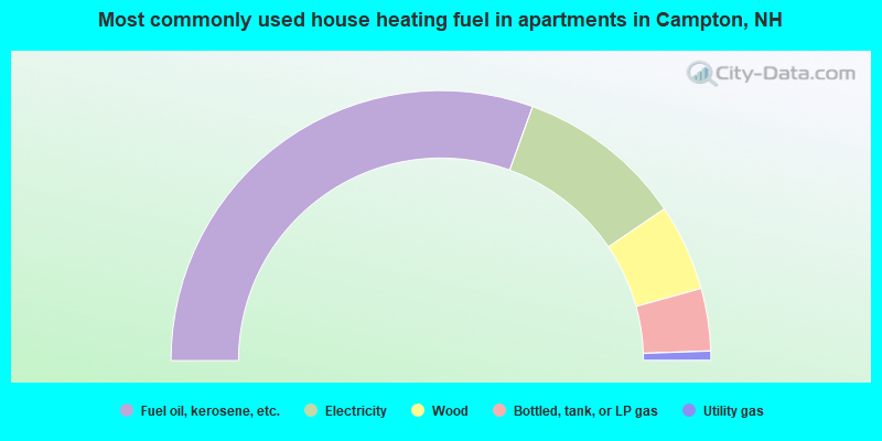
- 61.1%Fuel oil, kerosene, etc.
- 20.0%Electricity
- 10.4%Wood
- 7.5%Bottled, tank, or LP gas
- 1.1%Utility gas
Campton compared to New Hampshire state average:
- Unemployed percentage significantly below state average.
- Black race population percentage significantly below state average.
- Hispanic race population percentage significantly below state average.
- Foreign-born population percentage significantly below state average.
- Length of stay since moving in significantly above state average.
- Number of rooms per house significantly below state average.
- House age significantly below state average.

|
|
Total of 12 patent applications in 2008-2024.