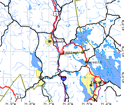
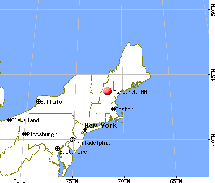
Ashland, New Hampshire

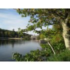
Ashland: Squam River
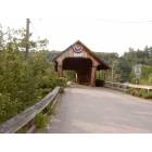
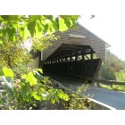
Ashland: Squam River covered bridge
Ashland: Delightful Covered Bridge
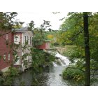
Ashland: Ashland NH Grist Mill and Dam
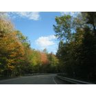
Ashland: Fall in New Hampshire!
Ashland: Swiftwater Covered Bridge
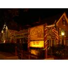
Ashland: Common Man
- add
your
Submit your own pictures of this town and show them to the world
- OSM Map
- General Map
- Google Map
- MSN Map
Population change since 2000: +6.2%
 |
| Males: 996 | |
| Females: 1,080 |
| Median resident age: | 43.1 years |
| New Hampshire median age: | 43.9 years |
Zip codes: 03217.
| Ashland: | $65,197 |
| NH: | $89,992 |
Estimated per capita income in 2022: $39,681 (it was $17,450 in 2000)
Ashland town income, earnings, and wages data
Estimated median house or condo value in 2022: $270,401 (it was $84,600 in 2000)
| Ashland: | $270,401 |
| NH: | $384,700 |
Mean prices in 2022: all housing units: $486,096; detached houses: $533,852; townhouses or other attached units: $375,744; in 2-unit structures: $230,260; in 3-to-4-unit structures: $242,363; in 5-or-more-unit structures: $588,257; mobile homes: $127,035
Detailed information about poverty and poor residents in Ashland, NH
Compare current foreclosures near Ashland, NH:
| Photo | Address | Area | Beds / Baths | Price | Details |
|---|---|---|---|---|---|

|
#1
Union Rd
Belmont, NH 03220
|
1,104 sq. feet
|
1 baths 2 beds |
show details | |

|
#2
Ward Hill Rd
Franklin, NH 03235
|
1,700 sq. feet
|
2 baths 3 beds |
show details | |

|
#3
Shaw Hill Rd
Sanbornton, NH 03269
|
1,976 sq. feet
|
1 baths 3 beds |
show details | |

|
#4
Strafford St
Laconia, NH 03246
|
1,820 sq. feet
|
2 baths 4 beds |
show details | |

|
#5
Pine Stump Rd
Sanbornton, NH 03269
|
1,976 sq. feet
|
1 baths 4 beds |
show details | |

|
#6
Governor Wentworth Hwy
Moultonborough, NH 03254
|
1,510 sq. feet
|
1 baths 3 beds |
show details | |

|
#7
Mechanic St
Laconia, NH 03246
|
2,537 sq. feet
|
2 baths 4 beds |
show details | |

|
#8
Brook Rd # 2
Sanbornton, NH 03269
|
2,128 sq. feet
|
2 baths 4 beds |
show details | |

|
#9
Adams St
Laconia, NH 03246
|
1,956 sq. feet
|
1 baths 3 beds |
show details | |

|
#10
Summit View Dr
Moultonborough, NH 03254
|
840 sq. feet
|
2 baths 3 beds |
show details |
| Photo | Address | Area | Beds / Baths | Price | Details |
|---|---|---|---|---|---|

|
#11
Province St
Laconia, NH 03246
|
818 sq. feet
|
1 baths 2 beds |
show details | |

|
#12
Eastman Hill Rd
Sanbornton, NH 03269
|
4,836 sq. feet
|
2 baths 4 beds |
show details | |

|
#13
Taylor Rd
Sanbornton, NH 03269
|
2,160 sq. feet
|
2 baths 4 beds |
show details | |

|
#14
Drake Rd
Sanbornton, NH 03269
|
2,376 sq. feet
|
2 baths 3 beds |
show details | |

|
#15
Pleasant St
Meredith, NH 03253
|
3,096 sq. feet
|
2 baths 4 beds |
show details | |

|
#16
Plymouth St
Meredith, NH 03253
|
2,232 sq. feet
|
2 baths 4 beds |
show details | |

|
#17
Union Ave
Laconia, NH 03246
|
6,055 sq. feet
|
2 baths - beds |
show details | |

|
#18
Streeter Woods Rd
Rumney, NH 03266
|
- sq. feet
|
- baths - beds |
show details | |

|
#19
Merrimac St # 1
Laconia, NH 03246
|
- sq. feet
|
- baths - beds |
show details | |

|
#20
Sand Hill Rd
Gilford, NH 03249
|
- sq. feet
|
- baths - beds |
show details |
| Photo | Address | Area | Beds / Baths | Price | Details |
|---|---|---|---|---|---|

|
#21
Academy St Apt 3
Laconia, NH 03246
|
- sq. feet
|
- baths - beds |
show details | |

|
#22
Durkee St # B
Laconia, NH 03246
|
- sq. feet
|
- baths - beds |
show details | |

|
#23
Horne Rd
Belmont, NH 03220
|
1,491 sq. feet
|
- baths - beds |
show details | |

|
#24
Landing Ln # 131
Laconia, NH 03246
|
- sq. feet
|
- baths - beds |
show details | |

|
#25
New Hebron Rd
Plymouth, NH 03264
|
- sq. feet
|
- baths - beds |
show details | |

|
#26
Annis Dr Unit 10
Gilford, NH 03249
|
- sq. feet
|
- baths - beds |
show details | |

|
#27
Calef Hill Rd
Tilton, NH 03276
|
- sq. feet
|
- baths - beds |
show details | |

|
#28
Lynnewood Rd
Laconia, NH 03246
|
- sq. feet
|
- baths - beds |
show details | |

|
#29
N Main St
Bristol, NH 03222
|
- sq. feet
|
- baths - beds |
show details | |

|
#30
Summit Dr
Campton, NH 03223
|
- sq. feet
|
- baths - beds |
show details |
| Photo | Address | Area | Beds / Baths | Price | Details |
|---|---|---|---|---|---|

|
#31
Endicott St N Unit 420
Laconia, NH 03246
|
- sq. feet
|
- baths - beds |
show details | |

|
#32
Beaver Path
Thornton, NH 03285
|
- sq. feet
|
- baths - beds |
show details | |

|
#33
Greyhound St
Moultonborough, NH 03254
|
- sq. feet
|
- baths - beds |
show details | |

|
#34
N Main St Apt 17
Laconia, NH 03246
|
- sq. feet
|
- baths - beds |
show details | |

|
#35
N Main St Apt 33
Laconia, NH 03246
|
- sq. feet
|
- baths - beds |
show details | |

|
#36
Estates Cir Apt 24
Laconia, NH 03246
|
- sq. feet
|
- baths - beds |
show details | |

|
#37
Woodland Ave
Gilford, NH 03249
|
- sq. feet
|
- baths - beds |
show details | |

|
#38
Academy St
Laconia, NH 03246
|
- sq. feet
|
- baths - beds |
show details | |

|
#39
Ragged Mountain Rd
Danbury, NH 03230
|
- sq. feet
|
- baths - beds |
show details | |

|
#40
Fairgrounds Rd
Plymouth, NH 03264
|
- sq. feet
|
- baths - beds |
show details |
| Photo | Address | Area | Beds / Baths | Price | Details |
|---|---|---|---|---|---|

|
#41
Pine Meadow Rd
New Hampton, NH 03256
|
- sq. feet
|
- baths - beds |
show details | |

|
#42
Mayhew Tpke
Plymouth, NH 03264
|
- sq. feet
|
- baths - beds |
show details | |

|
#43
Snow Rd
Hill, NH 03243
|
- sq. feet
|
- baths - beds |
show details | |

|
Check over 1 million property listings on Foreclosure.com!
|
browse all offers | |||


- 1,98395.5%White alone
- 321.5%Two or more races
- 281.3%Asian alone
- 180.9%Hispanic
- 90.4%Black alone
- 50.2%American Indian alone
- 10.05%Other race alone

Races in Ashland detailed stats: ancestries, foreign born residents, place of birth
According to our research of New Hampshire and other state lists, there were 5 registered sex offenders living in Ashland, New Hampshire as of May 23, 2024.
The ratio of all residents to sex offenders in Ashland is 415 to 1.
The ratio of registered sex offenders to all residents in this city is near the state average.
Type |
2009 |
2010 |
2011 |
2012 |
2013 |
2014 |
2015 |
2016 |
2017 |
2018 |
2019 |
2020 |
2021 |
2022 |
|---|---|---|---|---|---|---|---|---|---|---|---|---|---|---|
| Murders (per 100,000) | 0 (0.0) | 1 (48.2) | 0 (0.0) | 0 (0.0) | 0 (0.0) | 0 (0.0) | 0 (0.0) | 0 (0.0) | 0 (0.0) | 0 (0.0) | 0 (0.0) | 0 (0.0) | 0 (0.0) | 0 (0.0) |
| Rapes (per 100,000) | 1 (47.6) | 0 (0.0) | 2 (96.2) | 0 (0.0) | 1 (48.6) | 0 (0.0) | 0 (0.0) | 2 (97.3) | 2 (97.3) | 0 (0.0) | 0 (0.0) | 2 (97.4) | 0 (0.0) | 0 (0.0) |
| Robberies (per 100,000) | 1 (47.6) | 1 (48.2) | 1 (48.1) | 2 (96.4) | 1 (48.6) | 0 (0.0) | 0 (0.0) | 2 (97.3) | 2 (97.3) | 1 (48.6) | 0 (0.0) | 0 (0.0) | 0 (0.0) | 1 (50.8) |
| Assaults (per 100,000) | 0 (0.0) | 0 (0.0) | 1 (48.1) | 1 (48.2) | 3 (145.9) | 0 (0.0) | 1 (48.2) | 0 (0.0) | 1 (48.6) | 0 (0.0) | 1 (48.7) | 5 (243.5) | 0 (0.0) | 0 (0.0) |
| Burglaries (per 100,000) | 6 (285.4) | 8 (385.4) | 9 (432.9) | 10 (481.9) | 8 (389.1) | 6 (290.0) | 4 (192.7) | 6 (292.0) | 11 (535.0) | 6 (291.8) | 5 (243.5) | 8 (389.7) | 3 (145.2) | 0 (0.0) |
| Thefts (per 100,000) | 110 (5,233) | 42 (2,023) | 63 (3,030) | 29 (1,398) | 48 (2,335) | 32 (1,547) | 31 (1,493) | 23 (1,119) | 46 (2,237) | 31 (1,508) | 35 (1,705) | 38 (1,851) | 37 (1,791) | 43 (2,184) |
| Auto thefts (per 100,000) | 5 (237.9) | 2 (96.3) | 8 (384.8) | 1 (48.2) | 6 (291.8) | 1 (48.3) | 3 (144.5) | 3 (146.0) | 4 (194.6) | 4 (194.6) | 0 (0.0) | 1 (48.7) | 2 (96.8) | 3 (152.4) |
| Arson (per 100,000) | 0 (0.0) | 0 (0.0) | 0 (0.0) | 1 (48.2) | 0 (0.0) | 0 (0.0) | 0 (0.0) | 0 (0.0) | 0 (0.0) | 0 (0.0) | 0 (0.0) | 0 (0.0) | 0 (0.0) | 0 (0.0) |
| City-Data.com crime index | 300.7 | 226.4 | 283.3 | 132.0 | 226.7 | 86.0 | 94.4 | 183.9 | 259.2 | 110.9 | 95.0 | 231.9 | 89.5 | 114.8 |
The City-Data.com crime index weighs serious crimes and violent crimes more heavily. Higher means more crime, U.S. average is 246.1. It adjusts for the number of visitors and daily workers commuting into cities.
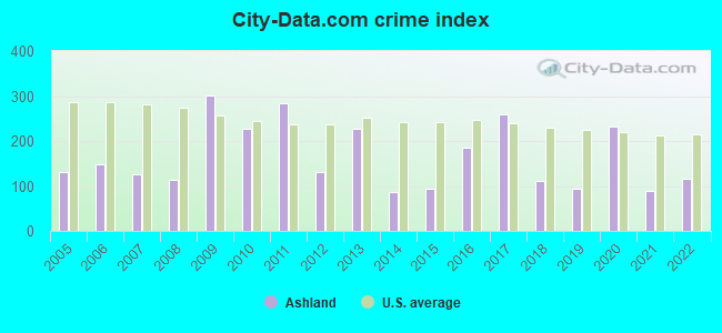
Crime rate in Ashland detailed stats: murders, rapes, robberies, assaults, burglaries, thefts, arson
Full-time law enforcement employees in 2021, including police officers: 5 (5 officers - 4 male; 1 female).
| Officers per 1,000 residents here: | 2.42 |
| New Hampshire average: | 2.14 |
 Recent articles from our blog. Our writers, many of them Ph.D. graduates or candidates, create easy-to-read articles on a wide variety of topics.

 | Move to NH - Suggested Areas & Towns? (108 replies) |
| Bad weather: do they know something we don't? (7 replies) |
| What's it like to live in or near Plymouth? (6 replies) |
| Catholic Towns In NH (11 replies) |
| Open/Concealed carry in NH (19 replies) |
| Restaurant suggestions near the Lake Region? (15 replies) |
Latest news from Ashland, NH collected exclusively by city-data.com from local newspapers, TV, and radio stations
Ancestries: English (23.8%), Irish (16.5%), French (14.7%), French Canadian (8.4%), German (8.1%), Italian (7.6%).
Current Local Time: EST time zone
Incorporated in 1868
Elevation: 551 feet
Land area: 11.3 square miles.
Population density: 184 people per square mile (very low).
40 residents are foreign born (1.3% Europe, 0.4% North America, 0.3% Latin America).
| This town: | 2.0% |
| New Hampshire: | 4.4% |
| Ashland town: | 2.9% ($2,457) |
| New Hampshire: | 2.3% ($2,946) |
Nearest city with pop. 50,000+: Manchester, NH  (50.6 miles , pop. 107,006).
Nearest city with pop. 200,000+: Boston, MA (99.6 miles , pop. 589,141).
Nearest city with pop. 1,000,000+: Bronx, NY (228.6 miles , pop. 1,332,650).
Nearest cities:
Latitude: 43.71 N, Longitude: 71.63 W
Area code: 603


Single-family new house construction building permits:
- 2022: 7 buildings, average cost: $405,700
- 2021: 9 buildings, average cost: $347,500
- 2020: 7 buildings, average cost: $347,500
- 2019: 6 buildings, average cost: $347,500
- 2018: 6 buildings, average cost: $347,500
- 2017: 2 buildings, average cost: $122,500
- 2016: 2 buildings, average cost: $122,500
- 2015: 4 buildings, average cost: $375,000
- 2014: 3 buildings, average cost: $633,300
- 2013: 6 buildings, average cost: $189,300
- 2012: 4 buildings, average cost: $130,000
- 2011: 4 buildings, average cost: $103,800
- 2010: 3 buildings, average cost: $121,700
- 2009: 7 buildings, average cost: $114,300
- 2008: 6 buildings, average cost: $158,300
- 2007: 5 buildings, average cost: $168,000
- 2006: 7 buildings, average cost: $150,000
- 2005: 11 buildings, average cost: $200,000
- 2004: 15 buildings, average cost: $126,700
- 2003: 13 buildings, average cost: $103,000
- 2002: 9 buildings, average cost: $100,600
- 2001: 7 buildings, average cost: $126,000
- 2000: 4 buildings, average cost: $99,500
- 1999: 4 buildings, average cost: $97,500


| Here: | 2.2% |
| New Hampshire: | 2.5% |


- Educational services (10.6%)
- Construction (10.3%)
- Accommodation & food services (8.6%)
- Health care (5.7%)
- Finance & insurance (4.3%)
- Food & beverage stores (3.9%)
- Miscellaneous manufacturing (3.7%)

- Construction (20.2%)
- Educational services (5.3%)
- Accommodation & food services (4.9%)
- Public administration (4.5%)
- Metal & metal products (4.1%)
- Repair & maintenance (3.5%)
- Utilities (3.5%)

- Educational services (15.9%)
- Accommodation & food services (12.4%)
- Health care (9.4%)
- Finance & insurance (5.9%)
- Social assistance (5.9%)
- Food & beverage stores (5.5%)
- Miscellaneous manufacturing (4.9%)

- Building and grounds cleaning and maintenance occupations (6.2%)
- Other production occupations, including supervisors (5.5%)
- Other management occupations, except farmers and farm managers (4.7%)
- Other sales and related occupations, including supervisors (4.7%)
- Metal workers and plastic workers (4.2%)
- Electrical equipment mechanics and other installation, maintenance, and repair workers, including supervisors (3.0%)
- Vehicle and mobile equipment mechanics, installers, and repairers (3.0%)

- Building and grounds cleaning and maintenance occupations (6.3%)
- Vehicle and mobile equipment mechanics, installers, and repairers (6.1%)
- Metal workers and plastic workers (5.7%)
- Other production occupations, including supervisors (5.3%)
- Other management occupations, except farmers and farm managers (5.3%)
- Electrical equipment mechanics and other installation, maintenance, and repair workers, including supervisors (5.1%)
- Other sales and related occupations, including supervisors (4.9%)

- Building and grounds cleaning and maintenance occupations (6.1%)
- Other production occupations, including supervisors (5.7%)
- Preschool, kindergarten, elementary, and middle school teachers (4.9%)
- Other sales and related occupations, including supervisors (4.5%)
- Cashiers (4.1%)
- Child care workers (4.1%)
- Other management occupations, except farmers and farm managers (4.1%)
Average climate in Ashland, New Hampshire
Based on data reported by over 4,000 weather stations


(lower is better)

Air Quality Index (AQI) level in 2022 was 46.9. This is significantly better than average.
| City: | 46.9 |
| U.S.: | 72.6 |

Ozone [ppb] level in 2022 was 29.9. This is about average. Closest monitor was 8.0 miles away from the city center.
| City: | 29.9 |
| U.S.: | 33.3 |

Particulate Matter (PM2.5) [µg/m3] level in 2022 was 4.52. This is significantly better than average. Closest monitor was 4.5 miles away from the city center.
| City: | 4.52 |
| U.S.: | 8.11 |
Tornado activity:
Ashland-area historical tornado activity is slightly below New Hampshire state average. It is 66% smaller than the overall U.S. average.
On 5/11/1973, a category F2 (max. wind speeds 113-157 mph) tornado 18.6 miles away from the Ashland town center .
On 7/3/1972, a category F2 tornado 22.2 miles away from the town center injured 7 people and caused between $5000 and $50,000 in damages.
Earthquake activity:
Ashland-area historical earthquake activity is significantly above New Hampshire state average. It is 71% smaller than the overall U.S. average.On 4/20/2002 at 10:50:47, a magnitude 5.3 (5.3 ML, Depth: 3.0 mi, Class: Moderate, Intensity: VI - VII) earthquake occurred 116.8 miles away from the city center
On 10/7/1983 at 10:18:46, a magnitude 5.3 (5.1 MB, 5.3 LG, 5.1 ML) earthquake occurred 136.4 miles away from Ashland center
On 4/20/2002 at 10:50:47, a magnitude 5.2 (5.2 MB, 4.2 MS, 5.2 MW, 5.0 MW) earthquake occurred 116.9 miles away from the city center
On 1/19/1982 at 00:14:42, a magnitude 4.7 (4.5 MB, 4.7 MD, 4.5 LG, Class: Light, Intensity: IV - V) earthquake occurred 14.3 miles away from the city center
On 10/16/2012 at 23:12:25, a magnitude 4.7 (4.7 ML, Depth: 10.0 mi) earthquake occurred 49.3 miles away from Ashland center
On 8/21/1996 at 07:54:14, a magnitude 3.8 (3.8 LG, 3.6 LG, Depth: 6.2 mi, Class: Light, Intensity: II - III) earthquake occurred 35.9 miles away from the city center
Magnitude types: regional Lg-wave magnitude (LG), body-wave magnitude (MB), duration magnitude (MD), local magnitude (ML), surface-wave magnitude (MS), moment magnitude (MW)
Natural disasters:
The number of natural disasters in Grafton County (32) is a lot greater than the US average (15).Major Disasters (Presidential) Declared: 20
Emergencies Declared: 9
Causes of natural disasters: Floods: 16, Storms: 16, Hurricanes: 3, Snows: 3, Winter Storms: 3, Tropical Storms: 2, Blizzard: 1, Heavy Rain: 1, Ice Storm: 1, Landslide: 1, Snowfall: 1, Snowstorm: 1, Wind: 1, Other: 1 (Note: some incidents may be assigned to more than one category).

Hospitals and medical centers near Ashland:
- SPEARE MEMORIAL HOSPITAL Critical Access Hospitals (about 5 miles away; PLYMOUTH, NH)
- NEWFOUND AREA NURSING ASSN (Home Health Center, about 10 miles away; BRISTOL, NH)
- MOULTONBORO VNS (Home Health Center, about 13 miles away; MOULTONBOROUGH, NH)
- BELKNAP COUNTY NURSING HOME (Nursing Home, about 14 miles away; LACONIA, NH)
- LACONIA CENTER, GENESIS HEALTHCARE (Nursing Home, about 14 miles away; LACONIA, NH)
- COMMUNITY HEALTH AND HOSPICE (Home Health Center, about 15 miles away; LACONIA, NH)
- CENTRAL NEW HAMPSHIRE KIDNEY CENTER (Dialysis Facility, about 15 miles away; LACONIA, NH)
Colleges/universities with over 2000 students nearest to Ashland:
- Plymouth State University (about 5 miles; Plymouth, NH; Full-time enrollment: 4,838)
- Dartmouth College (about 33 miles; Hanover, NH; FT enrollment: 6,030)
- NHTI-Concord's Community College (about 34 miles; Concord, NH; FT enrollment: 2,865)
- Southern New Hampshire University (about 47 miles; Manchester, NH; FT enrollment: 16,552)
- Saint Anselm College (about 51 miles; Manchester, NH; FT enrollment: 2,059)
- Mount Washington College (about 52 miles; Manchester, NH; FT enrollment: 2,187)
- University of New Hampshire-Main Campus (about 53 miles; Durham, NH; FT enrollment: 15,243)
Public elementary/middle school in Ashland:
- ASHLAND ELEMENTARY SCHOOL (Students: 161, Location: 16 EDUCATION DR., Grades: KG-8)
Points of interest:
Notable locations in Ashland: Ames Brook Campground (A), Ashland Fire and Rescue (B), Ashland Town Hall (C). Display/hide their locations on the map
Churches in Ashland include: First Free Will Baptist Church (A), Saint Agnes Church (B), Saint Marks Episcopal Church (C). Display/hide their locations on the map
Cemetery: Green Grove Cemetery (1). Display/hide its location on the map
Reservoir: Grist Mill Pond (A). Display/hide its location on the map
Streams, rivers, and creeks: Ames Brook (A). Display/hide its location on the map
Hotels: Black Horse Motor CT (Daniel Webster Highway), Comfort Inn Ashland (53 West Street).
Birthplace of: Person Colby Cheney - Politician, George Hoyt Whipple - (1978-1976), medical researcher, Nobelist.
Drinking water stations with addresses in Ashland and their reported violations in the past:
TILT N DINER (Population served: 300, Groundwater):Past health violations:Past monitoring violations:
- MCL, Monthly (TCR) - Between JUL-2011 and SEP-2011, Contaminant: Coliform. Follow-up actions: St Public Notif requested (SEP-08-2011), St Violation/Reminder Notice (SEP-08-2011), St Public Notif received (SEP-28-2011), St Compliance achieved (MAR-21-2012)
- MCL, Monthly (TCR) - Between APR-2005 and JUN-2005, Contaminant: Coliform. Follow-up actions: St Public Notif requested (JUL-22-2005), St Violation/Reminder Notice (JUL-22-2005), St Public Notif received (JUL-27-2005), St Compliance achieved (JAN-06-2006)
- One routine major monitoring violation
| This town: | 2.1 people |
| New Hampshire: | 2.5 people |
| This town: | 53.3% |
| Whole state: | 66.3% |
| This town: | 11.5% |
| Whole state: | 8.3% |
Likely homosexual households (counted as self-reported same-sex unmarried-partner households)
- Lesbian couples: 0.6% of all households
- Gay men: 0.4% of all households
| This town: | 10.2% |
| Whole state: | 6.5% |
| This town: | 4.5% |
| Whole state: | 2.8% |
Banks with branches in Ashland (2011 data):
- Meredith Village Savings Bank: Ashland Office at 5 Riverside Drive, branch established on 1934/06/30. Info updated 2009/03/03: Bank assets: $669.2 mil, Deposits: $513.6 mil, headquarters in Meredith, NH, positive income, Commercial Lending Specialization, 13 total offices
- Northway Bank: Ashland Branch at 130 Main Street, branch established on 1987/07/01. Info updated 2006/04/17: Bank assets: $814.2 mil, Deposits: $619.0 mil, headquarters in Berlin, NH, positive income, Commercial Lending Specialization, 17 total offices, Holding Company: Northway Financial, Inc.
For population 15 years and over in Ashland:

- Never married: 26.7%
- Now married: 49.2%
- Separated: 2.6%
- Widowed: 7.5%
- Divorced: 13.9%
For population 25 years and over in Ashland:
- High school or higher: 84.9%
- Bachelor's degree or higher: 18.4%
- Graduate or professional degree: 6.7%
- Unemployed: 5.1%
- Mean travel time to work (commute): 23.3 minutes


| Here: | 10.2 |
| New Hampshire average: | 10.9 |


Graphs represent county-level data. Detailed 2008 Election Results
Religion statistics for Ashland, NH (based on Grafton County data)


| Religion | Adherents | Congregations |
|---|---|---|
| Catholic | 9,503 | 12 |
| Mainline Protestant | 7,832 | 57 |
| Evangelical Protestant | 1,494 | 29 |
| Other | 1,320 | 11 |
| None | 68,969 | - |
Food Environment Statistics:
| Grafton County: | 3.87 / 10,000 pop. |
| New Hampshire: | 2.14 / 10,000 pop. |
| This county: | 0.23 / 10,000 pop. |
| State: | 0.15 / 10,000 pop. |
| Grafton County: | 1.29 / 10,000 pop. |
| New Hampshire: | 1.78 / 10,000 pop. |
| Grafton County: | 6.45 / 10,000 pop. |
| State: | 4.02 / 10,000 pop. |
| Here: | 14.41 / 10,000 pop. |
| State: | 9.70 / 10,000 pop. |
| This county: | 7.2% |
| New Hampshire: | 7.6% |
| Grafton County: | 22.9% |
| New Hampshire: | 24.4% |
| This county: | 15.9% |
| State: | 15.9% |
| Businesses in Ashland, NH | ||||
| Name | Count | Name | Count | |
|---|---|---|---|---|
| Burger King | 1 | Dunkin Donuts | 1 | |
| Circle K | 1 | MasterBrand Cabinets | 3 | |
| Comfort Inn | 1 | True Value | 1 | |
| Decora Cabinetry | 2 | UPS | 1 | |
Strongest AM radio stations in Ashland:
- WPNH (1300 AM; 5 kW; PLYMOUTH, NH; Owner: NORTHEAST COMMUNICATIONS CORPORATION)
- WEZS (1350 AM; 5 kW; LACONIA, NH; Owner: GARY W. HAMMOND)
- WRKO (680 AM; 50 kW; BOSTON, MA; Owner: ENTERCOM BOSTON LICENSE, LLC)
- WASR (1420 AM; 5 kW; WOLFEBORO, NH; Owner: RADIO WOLFEBORO, INC.)
- WNTK (1020 AM; 10 kW; NEWPORT, NH; Owner: KOOR COMMUNICATIONS, INC.)
- WEEI (850 AM; 50 kW; BOSTON, MA; Owner: ENTERCOM BOSTON LICENSE, LLC)
- WCRN (830 AM; 50 kW; WORCESTER, MA; Owner: CARTER BROADCASTING CORPORATION)
- WGIN (930 AM; 10 kW; ROCHESTER, NH; Owner: CAPSTAR TX LIMITED PARTNERSHIP)
- WNNZ (640 AM; 50 kW; WESTFIELD, MA; Owner: CLEAR CHANNEL BROADCASTING LICENSES, INC.)
- WKOX (1200 AM; 50 kW; FRAMINGHAM, MA; Owner: CAPSTAR TX LIMITED PARTNERSHIP)
- WBZ (1030 AM; 50 kW; BOSTON, MA; Owner: INFINITY BROADCASTING OPERATIONS, INC.)
- WBIX (1060 AM; 40 kW; NATICK, MA; Owner: LANGER BROADCASTING CORPORATION)
- WWZN (1510 AM; 50 kW; BOSTON, MA; Owner: ROSE CITY RADIO CORPORATION)
Strongest FM radio stations in Ashland:
- WPNH-FM (100.1 FM; PLYMOUTH, NH; Owner: NORTHEAST COMMUNICATIONS CORPORATION)
- WSCY (106.9 FM; MOULTONBOROUGH, NH; Owner: NORTHEAST COMMUNICATIONS CORPORATION)
- WVFM (105.7 FM; CAMPTON, NH; Owner: DEVON BROADCASTING COMPANY, INC.)
- WPKQ (103.7 FM; NORTH CONWAY, NH; Owner: CITADEL BROADCASTING COMPANY)
- WHOM (94.9 FM; MT. WASHINGTON, NH; Owner: CITADEL BROADCASTING COMPANY)
- WLKZ (104.9 FM; WOLFEBORO, NH; Owner: TELE-MEDIA COMPANY OF NEW HAMPSHIRE, L.L.C.)
- WLNH-FM (98.3 FM; LACONIA, NH; Owner: WLNH RADIO, INC)
- WNHI (93.3 FM; BELMONT, NH; Owner: CONCORD BROADCASTING, L.L.C.)
- WHDQ (106.1 FM; CLAREMONT, NH; Owner: GREAT NORTHERN RADIO, L.L.C.)
- WEVH (91.3 FM; HANOVER, NH; Owner: NEW HAMPSHIRE PUBLIC RADIO INC)
- WBHG (101.5 FM; MEREDITH, NH; Owner: WLNH RADIO, INC)
- WVPR (89.5 FM; WINDSOR, VT; Owner: VERMONT PUBLIC RADIO)
- WFTN-FM (94.1 FM; FRANKLIN, NH; Owner: NORTHEAST COMMUNICATIONS CORPORATION)
- WMEA (90.1 FM; PORTLAND, ME; Owner: MAINE PUBLIC BROADCASTING CORPORATION)
- WJJR (98.1 FM; RUTLAND, VT; Owner: 6 JOHNSON ROAD LICENSES, INC.)
- WZRT (97.1 FM; RUTLAND, VT; Owner: CAPSTAR TX LIMITED PARTNERSHIP)
- W245AF (96.9 FM; ASHLAND, NH; Owner: MOUNTAIN VIEW CHRISTIAN COMMUNICA)
- WEBK (105.3 FM; KILLINGTON, VT; Owner: 6 JOHNSON ROAD LICENSES, INC.)
- WGLV (91.7 FM; WOODSTOCK, VT; Owner: CHRISTIAN MINISTRIES INC)
- WHDQ-FM1 (106.1 FM; RUTLAND, VT; Owner: GREAT NORTHERN RADIO, L.L.C.)
TV broadcast stations around Ashland:
- WMTW-TV (Channel 8; POLAND SPRING, ME; Owner: WMTW BROADCAST GROUP, LLC)
- WMEA-TV (Channel 26; BIDDEFORD, ME; Owner: MAINE PUBLIC BROADCASTING CORP.)
- WCSH (Channel 6; PORTLAND, ME; Owner: PACIFIC AND SOUTHERN COMPANY, INC.)
- W15BK (Channel 15; HANOVER, NH; Owner: UNIVERSITY OF NEW HAMPSHIRE)
- Ashland, New Hampshire
- Fatal accident count20
- Vehicles involved in fatal accidents27
- Fatal accidents involving drunk persons:5
- Fatalities21
- Persons involved in fatal accidents46
- Pedestrians involved in fatal accidents0
- New Hampshire average
- Fatal accident count2169
- Vehicles involved in fatal accidents3039
- Fatal accidents involving drunk persons984
- Fatalities2386
- Persons involved in fatal accidents5170
- Pedestrians involved in fatal accidents120
- National Bridge Inventory (NBI) Statistics
- 18Number of bridges
- 217ft / 66.0mTotal length
- $47,130,000Total costs
- 91,106Total average daily traffic
- 6,589Total average daily truck traffic

- New bridges - historical statistics
- 11900-1909
- 21930-1939
- 21940-1949
- 11950-1959
- 101960-1969
- 11980-1989
- 11990-1999
FCC Registered Broadcast Land Mobile Towers:
3- Main St Fire Station (Lat: 43.693417 Lon: -71.629250), Call Sign: KFV836, Licensee ID: L00100806,
Assigned Frequencies: 33.9000 MHz, Grant Date: 12/09/1997, Expiration Date: 01/22/2003, Cancellation Date: 04/27/2003, Registrant: Ashland Fire Association, Main St, Ashland, NH 03217, Phone: (603) 968-7772
- Ashland Fire Associations (Lat: 43.693417 Lon: -71.629250), Call Sign: KGX949, Licensee ID: L00008549,
Assigned Frequencies: 31.9000 MHz, Grant Date: 08/08/2001, Expiration Date: 09/18/2011, Cancellation Date: 11/19/2003, Registrant: The State Of New Hampshire, Department Of Resources And Economic Development, 172 Pembroke Road, Concord, NH 03302-1856, Phone: (603) 271-2217, Fax: (603) 271-6488, Email:
- 9 Main Street (Lat: 43.693472 Lon: -71.630083), Type: Bant, Structure height: 4.6 m, Overall height: 7.6 m, Call Sign: WPUN981,
Assigned Frequencies: 160.110 MHz, 154.280 MHz, 159.900 MHz, 160.155 MHz, Grant Date: 04/05/2022, Expiration Date: 04/04/2032, Certifier: Douglas M Aiken, Registrant: Lakes Region Mutual Fire Aid Association, 62 Communications Drive, Laconia, NH 03246, Phone: (603) 528-9111, Fax: (603) 528-5989, Email:
FCC Registered Amateur Radio Licenses:
13 (See the full list of FCC Registered Amateur Radio Licenses in Ashland)FAA Registered Aircraft:
2- Aircraft: CESSNA TU206G (Category: Land, Seats: 6, Weight: Up to 12,499 Pounds, Speed: 132 mph), Engine: CONT MOTOR TSIO-520 SER (300 HP) (Reciprocating)
N-Number: 9851Z, N9851Z, N-9851Z, Serial Number: U20606701, Year manufactured: 1983, Airworthiness Date: 03/16/1983, Certificate Issue Date: 12/09/2013
Registrant (LLC): Airborne Flyer LLC, 85 Leavitt Hill Rd, Ashland, NH 03217 - Aircraft: CESSNA 414 (Category: Land, Engines: 2, Seats: 7, Weight: Up to 12,499 Pounds, Speed: 198 mph), Engine: CONT MOTOR TSIO-520 SER (300 HP) (Reciprocating)
N-Number: 999JL, N999JL, N-999JL, Serial Number: 414-0479, Year manufactured: 1973, Airworthiness Date: 08/03/1990, Certificate Issue Date: 11/02/2010
Registrant (LLC): Flying Swan LLC, 85 Leavitt Hill Rd, Ashland, NH 03217
2002 - 2018 National Fire Incident Reporting System (NFIRS) incidents
- Fire incident types reported to NFIRS in Ashland, NH
- 16864.6%Structure Fires
- 4216.2%Outside Fires
- 3413.1%Mobile Property/Vehicle Fires
- 166.2%Other
 According to the data from the years 2002 - 2018 the average number of fire incidents per year is 15. The highest number of fires - 28 took place in 2010, and the least - 4 in 2007. The data has an increasing trend.
 When looking into fire subcategories, the most incidents belonged to: Structure Fires (64.6%), and Outside Fires (16.2%).
- 83.2%Fuel oil, kerosene, etc.
- 7.2%Wood
- 5.0%Electricity
- 4.6%Bottled, tank, or LP gas

- 61.6%Fuel oil, kerosene, etc.
- 19.7%Electricity
- 14.9%Bottled, tank, or LP gas
- 1.4%No fuel used
- 1.1%Wood
- 0.8%Utility gas
- 0.5%Other fuel
Ashland compared to New Hampshire state average:
- Unemployed percentage below state average.
- Black race population percentage below state average.
- Hispanic race population percentage significantly below state average.
- Foreign-born population percentage significantly below state average.
- Length of stay since moving in significantly above state average.
- Number of rooms per house significantly below state average.
- House age significantly below state average.
- Percentage of population with a bachelor's degree or higher below state average.

|
Total of 1 patent application in 2008-2024.