Bridge Statistics for Wytheville, Virginia (VA)
Condition, Traffic, Stress, Structural Evaluation, Project Costs
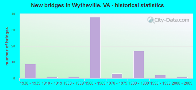
- New bridges - historical statistics
- 91930-1939
- 11940-1949
- 11950-1959
- 381960-1969
- 31970-1979
- 171980-1989
- 21990-1999
- 12000-2009

- Reconstructed bridges - Historical Statistics
- 111980-1989
- 101990-1999
- 32000-2009


- Bridge Condition - Deck
- 29.8%Good
- 38.3%Satisfactory
- 31.9%Fair

- Bridge Condition - Superstructure
- 23.4%Good
- 40.4%Satisfactory
- 31.9%Fair
- 4.3%Poor

- Bridge Condition - Substructure
- 38.3%Good
- 38.3%Satisfactory
- 21.3%Fair
- 2.1%Poor

- Bridge Condition - Channel
- 26.7%Very good
- 10.0%Good
- 43.3%Satisfactory
- 20.0%Fair

- Bridge Condition - Culverts
- 33.3%Good
- 33.3%Satisfactory
- 33.3%Fair
Find on map >> Show street view
Structure Number: 19515, Location: .22M TO 656 & 1.51M TO771 (Lat: 36.942608, Lng: -81.135267), Route carried "on" structure: US 11, Year Built: 1931, Year Reconstructed: 1997, Status: Open, Structure Length: 8.53m (27.99ft), Average Daily Traffic: 1,401 (year 2020), Truck Traffic: 2%, Average Future Daily Traffic: 1,961 (year 2040), Design Load: HS 20+Mod, Features Intersected: REED CREEK, Facility Carried by Structure: Lee Highway
Minimum Vertical Clearance: 30+ m (98+ ft), Kilometerpoint: 108.781, Lanes on structure: 2, Owner: State Highway Agency, Approaching Roadway Width: 7.3m (24.0ft), Material/Design: Steel, Design/Construction: Stringer/Multi-beam, Number Of Spans In Main Unit: 3, Length of Maximum Span: 32.0m (105.0ft), Curb-To-Curb Width: 9.1m (29.9ft), Out-to-Out Width: 9.8m (32.2ft)
Condition: Deck: Satisfactory, Superstructure: Satisfactory, Substructure: Good, Channel: Very good, Operating Rating: 72.6 metric tons, Method Used To Determine Operating Rating: Load and Resistance Factor (LRFR), Inventory Rating: 56.2 metric tons, Method Used To Determine Inventory Rating: Load and Resistance Factor (LRFR), Structural Evaluation: Equal to present minimum criteria, Deck Geometry: Meets minimum limits, Waterway Adequacy: Equal to present desirable criteria, Approach Roadway Alignment: Equal to present desirable criteria, Length Of Structure Improvement: 8.47m (27.79ft), Designated Inspection Frequency: Every 24 months, Inspection Date: Febuary 2021, Deck Structure Type: Concrete Cast-file-Place, Wearing Surface/Protective System: Deck Protection: Epoxy Coated Reinforcing
Find on map >> Show street view
Structure Number: 19516, Location: .40FRWCLWYTH;8.11TORT90 (Lat: 36.942472, Lng: -81.135744), Route carried "on" structure: US 11, Year Built: 1954, Year Reconstructed: 2000, Status: Open, Structure Length: 10.33m (33.89ft), Average Daily Traffic: 1,401 (year 2020), Truck Traffic: 2%, Average Future Daily Traffic: 1,961 (year 2040), Design Load: HS 20+Mod, Features Intersected: REED CREEK, Facility Carried by Structure: WEST LEE HWY
Minimum Vertical Clearance: 30+ m (98+ ft), Kilometerpoint: 108.767, Lanes on structure: 2, Owner: State Highway Agency, Approaching Roadway Width: 7.3m (24.0ft), Skew: 3 degrees, Material/Design: Steel continuous, Design/Construction: Stringer/Multi-beam, Number Of Spans In Main Unit: 5, Length of Maximum Span: 28.3m (92.8ft), Curb-To-Curb Width: 8.9m (29.2ft), Out-to-Out Width: 9.8m (32.2ft)
Condition: Deck: Good, Superstructure: Good, Substructure: Fair, Channel: Very good, Operating Rating: 39.9 metric tons, Method Used To Determine Operating Rating: Load and Resistance Factor (LRFR), Inventory Rating: 30.8 metric tons, Method Used To Determine Inventory Rating: Load and Resistance Factor (LRFR), Structural Evaluation: Somewhat better than minimum adequacy, Deck Geometry: High priority of corrective action, Waterway Adequacy: Better than present minimum criteria, Approach Roadway Alignment: Better than present minimum criteria, Length Of Structure Improvement: 11.52m (37.80ft), Designated Inspection Frequency: Every 24 months, Inspection Date: April 2020, Deck Structure Type: Concrete Cast-file-Place, Wearing Surface/Protective System: Deck Protection: Epoxy Coated Reinforcing
Find on map >> Show street view
Structure Number: 19524, Location: 2.7M TO 11 & 5.8M TO 690 (Lat: 36.904844, Lng: -81.112569), Route carried "on" structure: US 21, Year Built: 1932, Status: Open, Structure Length: 0.70m (2.30ft), Average Daily Traffic: 2,942 (year 2020), Truck Traffic: 4%, Average Future Daily Traffic: 3,236 (year 2040), Design Load: HS 20, Features Intersected: STREAM, Facility Carried by Structure: GRAYSON TPK.
Minimum Vertical Clearance: 30+ m (98+ ft), Kilometerpoint: 48.505, Lanes on structure: 2, Base Highway Network: Yes, Owner: State Highway Agency, Approaching Roadway Width: 6.1m (20.0ft), Material/Design: Concrete, Design/Construction: Slab, Number Of Spans In Main Unit: 1, Length of Maximum Span: 6.4m (21.0ft), Curb or Sidewalk Widths: Left: 0.4m (1.3ft), Right: 0.4m (1.3ft), Curb-To-Curb Width: 7.0m (23.0ft), Out-to-Out Width: 7.9m (25.9ft)
Condition: Deck: Satisfactory, Superstructure: Satisfactory, Substructure: Good, Channel: Fair, Operating Rating: 35.4 metric tons, Method Used To Determine Operating Rating: Load and Resistance Factor (LRFR), Inventory Rating: 27.2 metric tons, Method Used To Determine Inventory Rating: Load and Resistance Factor (LRFR), Structural Evaluation: Equal to present minimum criteria, Deck Geometry: High priority of replacement, Waterway Adequacy: Better than present minimum criteria, Approach Roadway Alignment: Better than present minimum criteria, Length Of Structure Improvement: 0.70m (2.30ft), Designated Inspection Frequency: Every 24 months, Inspection Date: June 2021, Bridge Improvement Cost: $66,000, Roadway Improvement Cost: $20,000, Total Project Cost: $112,000 ( Estimate for 2016), Deck Structure Type: Concrete Cast-file-Place, Wearing Surface/Protective System: Wearing Surface: Bituminous
Find on map >> Show street view
Structure Number: 19536, Location: 1.4M TO 11 & 2.8M TO 81 (Lat: 36.928119, Lng: -81.093514), Route carried "on" structure: US 21, Year Built: 1932, Year Reconstructed: 1998, Status: Open, Structure Length: 4.39m (14.40ft), Average Daily Traffic: 2,942 (year 2020), Truck Traffic: 4%, Average Future Daily Traffic: 3,236 (year 2040), Design Load: HS 20+Mod, Features Intersected: REED CREEK, Facility Carried by Structure: GRAYSON TURNPIKE
Minimum Vertical Clearance: 30+ m (98+ ft), Kilometerpoint: 51.815, Lanes on structure: 2, Owner: State Highway Agency, Approaching Roadway Width: 8.8m (28.9ft), Material/Design: Steel, Design/Construction: Stringer/Multi-beam, Number Of Spans In Main Unit: 2, Length of Maximum Span: 21.9m (71.9ft), Curb-To-Curb Width: 9.1m (29.9ft), Out-to-Out Width: 9.8m (32.2ft)
Condition: Deck: Good, Superstructure: Good, Substructure: Good, Channel: Satisfactory, Operating Rating: 89.8 metric tons, Method Used To Determine Operating Rating: Load and Resistance Factor (LRFR), Inventory Rating: 69.9 metric tons, Method Used To Determine Inventory Rating: Load and Resistance Factor (LRFR), Structural Evaluation: Better than present minimum criteria, Deck Geometry: Meets minimum limits, Waterway Adequacy: Equal to present desirable criteria, Approach Roadway Alignment: Equal to present desirable criteria, Length Of Structure Improvement: 4.39m (14.40ft), Designated Inspection Frequency: Every 24 months, Inspection Date: January 2021, Deck Structure Type: Concrete Cast-file-Place, Wearing Surface/Protective System: Deck Protection: Epoxy Coated Reinforcing
Find on map >> Show street view
Structure Number: 19538, Location: .75MTO680&6.80MTOBLANDCOL (Lat: 36.976808, Lng: -81.187919), Route carried "on" structure: US 52, Year Built: 1975, Year Reconstructed: 2002, Status: Open, Structure Length: 4.57m (14.99ft), Average Daily Traffic: 809 (year 2020), Truck Traffic: 9%, Average Future Daily Traffic: 890 (year 2040), Design Load: HS 20+Mod, Features Intersected: STONY FORK CK, Facility Carried by Structure: STONY FORK RD.
Minimum Vertical Clearance: 30+ m (98+ ft), Kilometerpoint: 82.960, Lanes on structure: 2, Owner: State Highway Agency, Approaching Roadway Width: 7.3m (24.0ft), Skew: 4 degrees, Material/Design: Steel, Design/Construction: Stringer/Multi-beam, Number Of Spans In Main Unit: 3, Length of Maximum Span: 15.2m (49.9ft), Curb or Sidewalk Widths: Left: 0.3m (1.0ft), Right: 0.3m (1.0ft), Curb-To-Curb Width: 9.1m (29.9ft), Out-to-Out Width: 10.4m (34.1ft)
Condition: Deck: Satisfactory, Superstructure: Fair, Substructure: Satisfactory, Channel: Very good, Operating Rating: 63.5 metric tons, Method Used To Determine Operating Rating: Load and Resistance Factor (LRFR), Inventory Rating: 49.0 metric tons, Method Used To Determine Inventory Rating: Load and Resistance Factor (LRFR), Structural Evaluation: Somewhat better than minimum adequacy, Deck Geometry: Equal to present minimum criteria, Waterway Adequacy: Better than present minimum criteria, Approach Roadway Alignment: Better than present minimum criteria, Length Of Structure Improvement: 4.57m (14.99ft), Designated Inspection Frequency: Every 24 months, Inspection Date: July 2021, Bridge Improvement Cost: $85,000, Roadway Improvement Cost: $16,000, Total Project Cost: $131,000 ( Estimate for 2019), Deck Structure Type: Concrete Cast-file-Place, Wearing Surface/Protective System: Wearing Surface: Latex Concrete
Find on map >> Show street view
Structure Number: 19543, Location: .09M TO 680 & 4.5 M TO 81 (Lat: 36.968303, Lng: -81.178889), Route carried "on" structure: US 52, Year Built: 1930, Year Reconstructed: 2003, Status: Open, Structure Length: 0.67m (2.20ft), Average Daily Traffic: 1,152 (year 2020), Truck Traffic: 7%, Average Future Daily Traffic: 1,163 (year 2040), Design Load: HS 20+Mod, Features Intersected: STREAM, Facility Carried by Structure: STONEY FORK RD.
Minimum Vertical Clearance: 30+ m (98+ ft), Kilometerpoint: 81.650, Lanes on structure: 2, Owner: State Highway Agency, Approaching Roadway Width: 7.0m (23.0ft), Material/Design: Concrete, Design/Construction: Slab, Number Of Spans In Main Unit: 1, Length of Maximum Span: 6.1m (20.0ft), Curb-To-Curb Width: 8.4m (27.6ft), Out-to-Out Width: 9.2m (30.2ft)
Condition: Deck: Good, Superstructure: Good, Substructure: Good, Channel: Good, Operating Rating: 89.8 metric tons, Method Used To Determine Operating Rating: Load and Resistance Factor (LRFR), Inventory Rating: 78.0 metric tons, Method Used To Determine Inventory Rating: Load and Resistance Factor (LRFR), Structural Evaluation: Better than present minimum criteria, Deck Geometry: Meets minimum limits, Waterway Adequacy: Better than present minimum criteria, Approach Roadway Alignment: Better than present minimum criteria, Length Of Structure Improvement: 0.70m (2.30ft), Designated Inspection Frequency: Every 24 months, Inspection Date: April 2021, Deck Structure Type: Concrete Cast-file-Place, Wearing Surface/Protective System: Deck Protection: Epoxy Coated Reinforcing
Find on map >> Show street view
Structure Number: 19544, Location: 3.25M TO 81 & 1.0M TO 680 (Lat: 36.966956, Lng: -81.165772), Route carried "on" structure: US 52, Year Built: 1930, Status: Posted for load, Structure Length: 0.67m (2.20ft), Average Daily Traffic: 1,152 (year 2020), Truck Traffic: 7%, Average Future Daily Traffic: 1,163 (year 2040), Design Load: H 20, Features Intersected: STREAM, Facility Carried by Structure: STONEY FORK RD.
Minimum Vertical Clearance: 30+ m (98+ ft), Kilometerpoint: 80.444, Lanes on structure: 2, Owner: State Highway Agency, Approaching Roadway Width: 6.7m (22.0ft), Skew: 3 degrees, Material/Design: Concrete, Design/Construction: Slab, Number Of Spans In Main Unit: 1, Length of Maximum Span: 6.1m (20.0ft), Curb-To-Curb Width: 7.0m (23.0ft), Out-to-Out Width: 7.9m (25.9ft)
Condition: Deck: Fair, Superstructure: Fair, Substructure: Satisfactory, Channel: Satisfactory, Operating Rating: 35.4 metric tons, Method Used To Determine Operating Rating: Load and Resistance Factor (LRFR), Inventory Rating: 27.2 metric tons, Method Used To Determine Inventory Rating: Load and Resistance Factor (LRFR), Structural Evaluation: Somewhat better than minimum adequacy, Deck Geometry: High priority of corrective action, Waterway Adequacy: Better than present minimum criteria, Approach Roadway Alignment: Better than present minimum criteria, Bridge Posting: Required (Relationship of Operating Rating to Maximum Legal Load: 10.0 - 19.9% below), Length Of Structure Improvement: 0.67m (2.20ft), Designated Inspection Frequency: Every 24 months, Inspection Date: June 2021, Bridge Improvement Cost: $46,000, Roadway Improvement Cost: $10,000, Total Project Cost: $73,000 ( Estimate for 2017), Deck Structure Type: Concrete Cast-file-Place, Wearing Surface/Protective System: Wearing Surface: Bituminous
Find on map >> Show street view
Structure Number: 19561, Location: 4.04TO81& 1.34MTOBLANDCO (Lat: 37.007317, Lng: -81.100250), Route carried "on" structure: Interstate 77, Year Built: 1969, Year Reconstructed: 1992, Status: Open, Structure Length: 3.54m (11.61ft), Average Daily Traffic: 12,968 (year 2020), Truck Traffic: 24%, Average Future Daily Traffic: 18,155 (year 2040), Design Load: HS 20+Mod, Features Intersected: ST. LUKE'S RD.
Minimum Vertical Clearance: 30+ m (98+ ft), Kilometerpoint: 72.727, Lanes on structure: 2, Lanes under structure: 2, Base Highway Network: Yes, Owner: State Highway Agency, Approaching Roadway Width: 12.2m (40.0ft), Material/Design: Steel, Design/Construction: Stringer/Multi-beam, Number Of Spans In Main Unit: 3, Length of Maximum Span: 12.2m (40.0ft), Curb or Sidewalk Widths: Left: 0.2m (0.7ft), Right: 0.2m (0.7ft), Curb-To-Curb Width: 11.8m (38.7ft), Out-to-Out Width: 12.8m (42.0ft)
Condition: Deck: Fair, Superstructure: Fair, Substructure: Fair, Operating Rating: 57.2 metric tons, Method Used To Determine Operating Rating: Load and Resistance Factor (LRFR), Inventory Rating: 44.5 metric tons, Method Used To Determine Inventory Rating: Load and Resistance Factor (LRFR), Structural Evaluation: Somewhat better than minimum adequacy, Deck Geometry: Equal to present minimum criteria, Underclear: Somewhat better than minimum adequacy, Approach Roadway Alignment: Better than present minimum criteria, Designated Inspection Frequency: Every 24 months, Inspection Date: May 2020, Deck Structure Type: Concrete Cast-file-Place, Wearing Surface/Protective System: Wearing Surface: Latex Concrete
Find on map >> Show street view
Structure Number: 19563, Location: 4.05MTO81&1.34MTOBLANDCO. (Lat: 37.007233, Lng: -81.100436), Route carried "on" structure: Interstate 77, Year Built: 1969, Year Reconstructed: 1992, Status: Open, Structure Length: 3.54m (11.61ft), Average Daily Traffic: 12,669 (year 2020), Truck Traffic: 24%, Average Future Daily Traffic: 17,737 (year 2040), Design Load: HS 20+Mod, Features Intersected: ST. LUKE'S RD.
Minimum Vertical Clearance: 30+ m (98+ ft), Kilometerpoint: 72.727, Lanes on structure: 2, Lanes under structure: 2, Base Highway Network: Yes, Owner: State Highway Agency, Approaching Roadway Width: 12.2m (40.0ft), Material/Design: Steel, Design/Construction: Stringer/Multi-beam, Number Of Spans In Main Unit: 3, Length of Maximum Span: 12.2m (40.0ft), Curb or Sidewalk Widths: Left: 0.2m (0.7ft), Right: 0.2m (0.7ft), Curb-To-Curb Width: 11.8m (38.7ft), Out-to-Out Width: 12.8m (42.0ft)
Condition: Deck: Fair, Superstructure: Fair, Substructure: Fair, Operating Rating: 57.2 metric tons, Method Used To Determine Operating Rating: Load and Resistance Factor (LRFR), Inventory Rating: 44.5 metric tons, Method Used To Determine Inventory Rating: Load and Resistance Factor (LRFR), Structural Evaluation: Somewhat better than minimum adequacy, Deck Geometry: Equal to present minimum criteria, Underclear: Somewhat better than minimum adequacy, Approach Roadway Alignment: Better than present minimum criteria, Designated Inspection Frequency: Every 24 months, Inspection Date: May 2020, Deck Structure Type: Concrete Cast-file-Place, Wearing Surface/Protective System: Wearing Surface: Latex Concrete
Find on map >> Show street view
Structure Number: 19565, Location: 1.63MTO81&3.76MTOBLANDC.L (Lat: 36.981878, Lng: -81.071700), Route carried "on" structure: Interstate 77, Year Built: 1969, Year Reconstructed: 1993, Status: Open, Structure Length: 8.60m (28.22ft), Average Daily Traffic: 12,968 (year 2020), Truck Traffic: 23%, Average Future Daily Traffic: 18,155 (year 2040), Design Load: HS 20+Mod, Features Intersected: COVE CREEK
Minimum Vertical Clearance: 30+ m (98+ ft), Kilometerpoint: 69.026, Lanes on structure: 2, Base Highway Network: Yes, Owner: State Highway Agency, Approaching Roadway Width: 16.2m (53.1ft), Skew: 4 degrees, Material/Design: Steel, Design/Construction: Stringer/Multi-beam, Number Of Spans In Main Unit: 4, Length of Maximum Span: 21.6m (70.9ft), Curb or Sidewalk Widths: Left: 0.2m (0.7ft), Right: 0.2m (0.7ft), Curb-To-Curb Width: 7.3m (24.0ft), Out-to-Out Width: 11.0m (36.1ft)
Condition: Deck: Fair, Superstructure: Poor, Substructure: Fair, Channel: Good, Operating Rating: 50.8 metric tons, Method Used To Determine Operating Rating: Load and Resistance Factor (LRFR), Inventory Rating: 39.0 metric tons, Method Used To Determine Inventory Rating: Load and Resistance Factor (LRFR), Structural Evaluation: Meets minimum limits, Deck Geometry: High priority of replacement, Waterway Adequacy: Better than present minimum criteria, Approach Roadway Alignment: Better than present minimum criteria, Length Of Structure Improvement: 8.60m (28.22ft), Designated Inspection Frequency: Every 24 months, Other Special Inspection Frequency: Every 12 months, Inspection Date: July 2021, Other Special Inspection Date: July 2021, Bridge Improvement Cost: $764,000, Roadway Improvement Cost: $25,000, Total Project Cost: $1,026,000 ( Estimate for 2018), Deck Structure Type: Concrete Cast-file-Place, Wearing Surface/Protective System: Wearing Surface: Latex Concrete, Membrane: Built-up, Deck Protection: Other
Find on map >> Show street view
Structure Number: 19566, Location: 1.65MTO81&3.74MTOBLANDC.L (Lat: 36.981936, Lng: -81.072036), Route carried "on" structure: Interstate 77, Year Built: 1969, Year Reconstructed: 1993, Status: Open, Structure Length: 8.05m (26.41ft), Average Daily Traffic: 12,669 (year 2020), Truck Traffic: 24%, Average Future Daily Traffic: 17,737 (year 2040), Design Load: HS 20+Mod, Features Intersected: COVE CREEK
Minimum Vertical Clearance: 30+ m (98+ ft), Kilometerpoint: 68.447, Lanes on structure: 2, Base Highway Network: Yes, Owner: State Highway Agency, Approaching Roadway Width: 16.2m (53.1ft), Skew: 4 degrees, Material/Design: Steel, Design/Construction: Stringer/Multi-beam, Number Of Spans In Main Unit: 4, Length of Maximum Span: 21.6m (70.9ft), Curb or Sidewalk Widths: Left: 0.2m (0.7ft), Right: 0.2m (0.7ft), Curb-To-Curb Width: 7.3m (24.0ft), Out-to-Out Width: 11.0m (36.1ft)
Condition: Deck: Fair, Superstructure: Poor, Substructure: Fair, Channel: Satisfactory, Operating Rating: 50.8 metric tons, Method Used To Determine Operating Rating: Load and Resistance Factor (LRFR), Inventory Rating: 39.0 metric tons, Method Used To Determine Inventory Rating: Load and Resistance Factor (LRFR), Structural Evaluation: Meets minimum limits, Deck Geometry: High priority of replacement, Waterway Adequacy: Better than present minimum criteria, Approach Roadway Alignment: Better than present minimum criteria, Length Of Structure Improvement: 8.05m (26.41ft), Designated Inspection Frequency: Every 24 months, Other Special Inspection Frequency: Every 12 months, Inspection Date: July 2021, Other Special Inspection Date: July 2021, Bridge Improvement Cost: $17,000, Roadway Improvement Cost: $10,000, Total Project Cost: $35,000 ( Estimate for 2018), Deck Structure Type: Concrete Cast-file-Place, Wearing Surface/Protective System: Wearing Surface: Latex Concrete, Membrane: Built-up, Deck Protection: Other
Find on map >> Show street view
Structure Number: 19573, Location: 2.81MTO81&2.58MTOBLANDCOL (Lat: 36.996647, Lng: -81.082564), Route carried "on" structure: Interstate 77, Year Built: 1968, Status: Open, Structure Length: 1.22m (4.00ft), Average Daily Traffic: 12,968 (year 2020), Truck Traffic: 28%, Average Future Daily Traffic: 18,155 (year 2040), Design Load: H 20, Features Intersected: N&SBL OVER COVE CREEK
Minimum Vertical Clearance: 30+ m (98+ ft), Kilometerpoint: 70.281, Lanes on structure: 4, Base Highway Network: Yes, Owner: State Highway Agency, Approaching Roadway Width: 35.4m (116.1ft), Skew: 2 degrees, Material/Design: Concrete, Design/Construction: Culvert, Number Of Spans In Main Unit: 3, Length of Maximum Span: 4.0m (13.1ft)
Condition: Channel: Satisfactory, Culverts: Satisfactory, Operating Rating: 44.5 metric tons, Method Used To Determine Operating Rating: Field evaluation and documented engineering judgment, Inventory Rating: 32.7 metric tons, Method Used To Determine Inventory Rating: Field evaluation and documented engineering judgment, Structural Evaluation: Equal to present minimum criteria, Waterway Adequacy: Better than present minimum criteria, Approach Roadway Alignment: Better than present minimum criteria, Designated Inspection Frequency: Every 24 months, Inspection Date: Febuary 2021
Find on map >> Show street view
Structure Number: 19614, Location: 0.14M TO 11; 0.39M TO 81 (Lat: 36.940583, Lng: -81.152253), Route carried "on" structure: Ramp Interstate 81, Year Built: 1963, Status: Open, Structure Length: 11.11m (36.45ft), Average Daily Traffic: 224 (year 2020), Average Future Daily Traffic: 315 (year 2040), Design Load: HS 20+Mod, Features Intersected: I-81
Minimum Vertical Clearance: 30+ m (98+ ft), Kilometerpoint: 109.042, Lanes on structure: 1, Lanes under structure: 4, Base Highway Network: Yes, Owner: State Highway Agency, Approaching Roadway Width: 7.3m (24.0ft), Skew: 5 degrees, Material/Design: Steel, Design/Construction: Stringer/Multi-beam, Number Of Spans In Main Unit: 4, Length of Maximum Span: 31.6m (103.7ft), Curb or Sidewalk Widths: Left: 0.5m (1.6ft), Right: 0.5m (1.6ft), Curb-To-Curb Width: 6.1m (20.0ft), Out-to-Out Width: 7.7m (25.3ft)
Condition: Deck: Fair, Superstructure: Fair, Substructure: Satisfactory, Operating Rating: 60.8 metric tons, Method Used To Determine Operating Rating: Load and Resistance Factor (LRFR), Inventory Rating: 46.3 metric tons, Method Used To Determine Inventory Rating: Load and Resistance Factor (LRFR), Structural Evaluation: Somewhat better than minimum adequacy, Deck Geometry: Somewhat better than minimum adequacy, Underclear: Somewhat better than minimum adequacy, Approach Roadway Alignment: Better than present minimum criteria, Length Of Structure Improvement: 11.13m (36.52ft), Designated Inspection Frequency: Every 24 months, Inspection Date: March 2021, Bridge Improvement Cost: $300,000, Roadway Improvement Cost: $25,000, Total Project Cost: $423,000 ( Estimate for 2015), Deck Structure Type: Concrete Cast-file-Place, Wearing Surface/Protective System: Wearing Surface: Latex Concrete
Find on map >> Show street view
Structure Number: 19616, Location: 1.47M TO 11 & 1.82M TO 52 (Lat: 36.950672, Lng: -81.129428), Route carried "on" structure: Interstate 81, Year Built: 1964, Year Reconstructed: 1993, Status: Open, Structure Length: 3.67m (12.04ft), Average Daily Traffic: 11,215 (year 2020), Truck Traffic: 21%, Average Future Daily Traffic: 15,701 (year 2040), Design Load: HS 20+Mod, Features Intersected: WEST RIDGE RD.
Minimum Vertical Clearance: 30+ m (98+ ft), Kilometerpoint: 111.649, Lanes on structure: 2, Lanes under structure: 2, Base Highway Network: Yes, Owner: State Highway Agency, Approaching Roadway Width: 12.2m (40.0ft), Material/Design: Concrete, Design/Construction: Tee Beam, Number Of Spans In Main Unit: 3, Length of Maximum Span: 12.2m (40.0ft), Curb-To-Curb Width: 12.8m (42.0ft), Out-to-Out Width: 13.4m (44.0ft)
Condition: Deck: Good, Superstructure: Good, Substructure: Good, Operating Rating: 65.3 metric tons, Method Used To Determine Operating Rating: Load and Resistance Factor (LRFR), Inventory Rating: 49.9 metric tons, Method Used To Determine Inventory Rating: Load and Resistance Factor (LRFR), Structural Evaluation: Better than present minimum criteria, Deck Geometry: Equal to present desirable criteria, Underclear: Meets minimum limits, Approach Roadway Alignment: Better than present minimum criteria, Designated Inspection Frequency: Every 24 months, Inspection Date: May 2020, Deck Structure Type: Concrete Cast-file-Place, Wearing Surface/Protective System: Wearing Surface: Latex Concrete
Find on map >> Show street view
Structure Number: 19618, Location: 1.47M TO 11 & 1.82M TO 52 (Lat: 36.950908, Lng: -81.129561), Route carried "on" structure: Interstate 81, Year Built: 1964, Year Reconstructed: 1992, Status: Open, Structure Length: 3.67m (12.04ft), Average Daily Traffic: 11,055 (year 2020), Truck Traffic: 21%, Average Future Daily Traffic: 15,477 (year 2040), Design Load: HS 20+Mod, Features Intersected: WEST RIDGE RD.
Minimum Vertical Clearance: 4.62m (15.16ft), Kilometerpoint: 111.037, Lanes on structure: 2, Lanes under structure: 2, Base Highway Network: Yes, Owner: State Highway Agency, Approaching Roadway Width: 12.2m (40.0ft), Material/Design: Concrete, Design/Construction: Tee Beam, Number Of Spans In Main Unit: 3, Length of Maximum Span: 12.2m (40.0ft), Curb-To-Curb Width: 12.8m (42.0ft), Out-to-Out Width: 13.4m (44.0ft)
Condition: Deck: Good, Superstructure: Good, Substructure: Good, Operating Rating: 65.3 metric tons, Method Used To Determine Operating Rating: Load and Resistance Factor (LRFR), Inventory Rating: 49.9 metric tons, Method Used To Determine Inventory Rating: Load and Resistance Factor (LRFR), Structural Evaluation: Better than present minimum criteria, Deck Geometry: Equal to present desirable criteria, Underclear: Meets minimum limits, Approach Roadway Alignment: Better than present minimum criteria, Length Of Structure Improvement: 3.66m (12.01ft), Designated Inspection Frequency: Every 24 months, Inspection Date: May 2020, Bridge Improvement Cost: $150,000, Roadway Improvement Cost: $25,000, Total Project Cost: $228,000 ( Estimate for 2015), Deck Structure Type: Concrete Cast-file-Place, Wearing Surface/Protective System: Wearing Surface: Latex Concrete
Find on map >> Show street view
Structure Number: 19621, Location: .39M TO 11 & 2.9M TO 52 (Lat: 36.944222, Lng: -81.148094), Route carried "on" structure: Interstate 81, Year Built: 1964, Year Reconstructed: 1986, Status: Open, Structure Length: 16.77m (55.02ft), Average Daily Traffic: 11,055 (year 2020), Truck Traffic: 19%, Average Future Daily Traffic: 15,477 (year 2040), Design Load: HS 20+Mod, Features Intersected: REED CREEK
Minimum Vertical Clearance: 30+ m (98+ ft), Kilometerpoint: 109.789, Lanes on structure: 2, Base Highway Network: Yes, Owner: State Highway Agency, Approaching Roadway Width: 11.0m (36.1ft), Material/Design: Steel, Design/Construction: Stringer/Multi-beam, Number Of Spans In Main Unit: 5, Length of Maximum Span: 42.7m (140.1ft), Curb or Sidewalk Widths: Left: 0.8m (2.6ft), Right: 0.5m (1.6ft), Curb-To-Curb Width: 8.8m (28.9ft), Out-to-Out Width: 10.7m (35.1ft)
Condition: Deck: Satisfactory, Superstructure: Fair, Substructure: Satisfactory, Channel: Satisfactory, Operating Rating: 69.9 metric tons, Method Used To Determine Operating Rating: Load and Resistance Factor (LRFR), Inventory Rating: 53.5 metric tons, Method Used To Determine Inventory Rating: Load and Resistance Factor (LRFR), Structural Evaluation: Somewhat better than minimum adequacy, Deck Geometry: Meets minimum limits, Waterway Adequacy: Better than present minimum criteria, Approach Roadway Alignment: Better than present minimum criteria, Length Of Structure Improvement: 16.76m (54.99ft), Designated Inspection Frequency: Every 24 months, Inspection Date: August 2021, Bridge Improvement Cost: $300,000, Roadway Improvement Cost: $19,000, Total Project Cost: $415,000 ( Estimate for 2019), Deck Structure Type: Concrete Cast-file-Place, Wearing Surface/Protective System: Wearing Surface: Latex Concrete
Find on map >> Show street view
Structure Number: 19628, Location: 1.4M TO 11 & 1.89M TO 52 (Lat: 36.950347, Lng: -81.130431), Route carried "on" structure: Interstate 81, Year Built: 1964, Status: Open, Structure Length: 0.67m (2.20ft), Average Daily Traffic: 11,215 (year 2020), Truck Traffic: 21%, Average Future Daily Traffic: 15,701 (year 2040), Design Load: H 20, Features Intersected: NBL&SBL OVER STREAM
Minimum Vertical Clearance: 30+ m (98+ ft), Kilometerpoint: 110.941, Lanes on structure: 4, Base Highway Network: Yes, Owner: State Highway Agency, Approaching Roadway Width: 44.2m (145.0ft), Material/Design: Concrete, Design/Construction: Culvert, Number Of Spans In Main Unit: 3, Length of Maximum Span: 2.1m (6.9ft)
Condition: Channel: Fair, Culverts: Satisfactory, Operating Rating: 44.5 metric tons, Method Used To Determine Operating Rating: Field evaluation and documented engineering judgment, Inventory Rating: 32.7 metric tons, Method Used To Determine Inventory Rating: Field evaluation and documented engineering judgment, Structural Evaluation: Equal to present minimum criteria, Waterway Adequacy: Better than present minimum criteria, Approach Roadway Alignment: Better than present minimum criteria, Designated Inspection Frequency: Every 24 months, Inspection Date: December 2020
Find on map >> Show street view
Structure Number: 19652, Location: 2.85M TO659&.65MTO 600 (Lat: 37.001825, Lng: -81.075478), Route carried "on" structure: County highway 603, Year Built: 1982, Status: Open, Structure Length: 1.37m (4.49ft), Average Daily Traffic: 423 (year 2020), Truck Traffic: 2%, Average Future Daily Traffic: 465 (year 2040), Design Load: HS 20+Mod, Features Intersected: COVE CREEK, Facility Carried by Structure: SMITH HOLLOW RD.
Minimum Vertical Clearance: 30+ m (98+ ft), Kilometerpoint: 4.599, Lanes on structure: 2, Owner: State Highway Agency, Approaching Roadway Width: 6.4m (21.0ft), Skew: 4 degrees, Material/Design: Concrete, Design/Construction: Slab, Number Of Spans In Main Unit: 2, Length of Maximum Span: 7.0m (23.0ft), Curb or Sidewalk Widths: Left: 0.3m (1.0ft), Right: 0.3m (1.0ft), Curb-To-Curb Width: 7.6m (24.9ft), Out-to-Out Width: 8.8m (28.9ft)
Condition: Deck: Good, Superstructure: Good, Substructure: Satisfactory, Channel: Satisfactory, Operating Rating: 89.8 metric tons, Method Used To Determine Operating Rating: Load and Resistance Factor (LRFR), Inventory Rating: 88.9 metric tons, Method Used To Determine Inventory Rating: Load and Resistance Factor (LRFR), Structural Evaluation: Equal to present minimum criteria, Deck Geometry: Meets minimum limits, Waterway Adequacy: Better than present minimum criteria, Approach Roadway Alignment: Better than present minimum criteria, Designated Inspection Frequency: Every 24 months, Inspection Date: July 2021, Deck Structure Type: Concrete Cast-file-Place
Find on map >> Show street view
Structure Number: 19654, Location: 1.95MTO600S&1.55MTO659 (Lat: 36.986461, Lng: -81.076194), Route carried "on" structure: County highway 603, Year Built: 1969, Status: Open, Structure Length: 4.69m (15.39ft), Average Daily Traffic: 423 (year 2020), Truck Traffic: 2%, Average Future Daily Traffic: 465 (year 2040), Design Load: HS 20, Features Intersected: COVE CREEK, Facility Carried by Structure: COVE RD.
Minimum Vertical Clearance: 30+ m (98+ ft), Kilometerpoint: 2.541, Lanes on structure: 2, Owner: State Highway Agency, Approaching Roadway Width: 6.4m (21.0ft), Material/Design: Steel, Design/Construction: Stringer/Multi-beam, Number Of Spans In Main Unit: 3, Length of Maximum Span: 17.1m (56.1ft), Curb or Sidewalk Widths: Left: 0.2m (0.7ft), Right: 0.2m (0.7ft), Curb-To-Curb Width: 8.7m (28.5ft), Out-to-Out Width: 9.8m (32.2ft)
Condition: Deck: Satisfactory, Superstructure: Satisfactory, Substructure: Fair, Channel: Very good, Operating Rating: 88.9 metric tons, Method Used To Determine Operating Rating: Load and Resistance Factor (LRFR), Inventory Rating: 68.0 metric tons, Method Used To Determine Inventory Rating: Load and Resistance Factor (LRFR), Structural Evaluation: Somewhat better than minimum adequacy, Deck Geometry: Somewhat better than minimum adequacy, Waterway Adequacy: Better than present minimum criteria, Approach Roadway Alignment: Better than present minimum criteria, Designated Inspection Frequency: Every 24 months, Inspection Date: April 2020, Deck Structure Type: Concrete Cast-file-Place, Wearing Surface/Protective System: Wearing Surface: Epoxy Overlay, Membrane: Epoxy
Find on map >> Show street view
Structure Number: 19655, Location: 1.6MTO659&1.9MTO600S (Lat: 36.986864, Lng: -81.075272), Route carried "on" structure: County highway 603, Year Built: 1969, Status: Open, Structure Length: 7.71m (25.30ft), Average Daily Traffic: 423 (year 2020), Truck Traffic: 2%, Average Future Daily Traffic: 465 (year 2040), Design Load: HS 20, Features Intersected: RT 77
Minimum Vertical Clearance: 30+ m (98+ ft), Kilometerpoint: 2.650, Lanes on structure: 2, Lanes under structure: 4, Owner: State Highway Agency, Approaching Roadway Width: 7.6m (24.9ft), Material/Design: Steel, Design/Construction: Stringer/Multi-beam, Number Of Spans In Main Unit: 4, Length of Maximum Span: 21.6m (70.9ft), Curb or Sidewalk Widths: Left: 0.2m (0.7ft), Right: 0.2m (0.7ft), Curb-To-Curb Width: 8.7m (28.5ft), Out-to-Out Width: 9.8m (32.2ft)
Condition: Deck: Good, Superstructure: Good, Substructure: Good, Operating Rating: 83.5 metric tons, Method Used To Determine Operating Rating: Load and Resistance Factor (LRFR), Inventory Rating: 64.4 metric tons, Method Used To Determine Inventory Rating: Load and Resistance Factor (LRFR), Structural Evaluation: Better than present minimum criteria, Deck Geometry: Somewhat better than minimum adequacy, Underclear: Equal to present minimum criteria, Approach Roadway Alignment: Better than present minimum criteria, Length Of Structure Improvement: 7.71m (25.30ft), Designated Inspection Frequency: Every 24 months, Inspection Date: April 2020, Bridge Improvement Cost: $38,000, Roadway Improvement Cost: $25,000, Total Project Cost: $82,000, Deck Structure Type: Concrete Cast-file-Place, Wearing Surface/Protective System: Wearing Surface: Epoxy Overlay
Find on map >> Show street view
Structure Number: 19702, Location: .16MTOSCLWYTVL&.10MTO696 (Lat: 36.934094, Lng: -81.072969), Route carried "on" structure: County highway 640, Year Built: 1982, Status: Open, Structure Length: 6.10m (20.01ft), Average Daily Traffic: 556 (year 2020), Average Future Daily Traffic: 612 (year 2040), Design Load: HS 20+Mod, Features Intersected: REED CREEK, Facility Carried by Structure: BARRETT MILL ROAD
Minimum Vertical Clearance: 30+ m (98+ ft), Kilometerpoint: 13.290, Lanes on structure: 2, Owner: State Highway Agency, Approaching Roadway Width: 6.4m (21.0ft), Skew: 3 degrees, Material/Design: Prestressed concrete, Design/Construction: Tee Beam, Number Of Spans In Main Unit: 4, Length of Maximum Span: 15.2m (49.9ft), Curb or Sidewalk Widths: Left: 0.2m (0.7ft), Right: 0.2m (0.7ft), Curb-To-Curb Width: 7.9m (25.9ft), Out-to-Out Width: 9.1m (29.9ft)
Condition: Deck: Fair, Superstructure: Fair, Substructure: Fair, Channel: Satisfactory, Operating Rating: 58.1 metric tons, Method Used To Determine Operating Rating: Load and Resistance Factor (LRFR), Inventory Rating: 36.3 metric tons, Method Used To Determine Inventory Rating: Load and Resistance Factor (LRFR), Structural Evaluation: Somewhat better than minimum adequacy, Deck Geometry: Somewhat better than minimum adequacy, Waterway Adequacy: Better than present minimum criteria, Approach Roadway Alignment: Better than present minimum criteria, Length Of Structure Improvement: 6.10m (20.01ft), Designated Inspection Frequency: Every 24 months, Inspection Date: December 2021, Bridge Improvement Cost: $235,000, Roadway Improvement Cost: $10,000, Total Project Cost: $319,000, Deck Structure Type: Concrete Cast-file-Place, Wearing Surface/Protective System: Wearing Surface: Monolithic Concrete
Find on map >> Show street view
Structure Number: 19719, Location: 2.1M TO 667 & .00M TO 653 (Lat: 36.902444, Lng: -81.151086), Route carried "on" structure: County highway 654, Year Built: 1990, Status: Open, Structure Length: 0.98m (3.22ft), Average Daily Traffic: 142 (year 2017), Average Future Daily Traffic: 201 (year 2040), Design Load: HS 20, Features Intersected: SHUFFLE RUN, Facility Carried by Structure: Berea Road
Minimum Vertical Clearance: 30+ m (98+ ft), Kilometerpoint: 1.609, Lanes on structure: 2, Owner: State Highway Agency, Approaching Roadway Width: 6.7m (22.0ft), Skew: 1 degrees, Material/Design: Steel, Design/Construction: Culvert, Number Of Spans In Main Unit: 4, Length of Maximum Span: 2.1m (6.9ft)
Condition: Channel: Satisfactory, Culverts: Fair, Operating Rating: 44.5 metric tons, Method Used To Determine Operating Rating: Field evaluation and documented engineering judgment, Inventory Rating: 32.7 metric tons, Method Used To Determine Inventory Rating: Field evaluation and documented engineering judgment, Structural Evaluation: Somewhat better than minimum adequacy, Waterway Adequacy: Better than present minimum criteria, Approach Roadway Alignment: Better than present minimum criteria, Designated Inspection Frequency: Every 24 months, Inspection Date: Febuary 2021
Find on map >> Show street view
Structure Number: 19721, Location: .6M TO 667 & 1.5M TO 653 (Lat: 36.918075, Lng: -81.145481), Route carried "on" structure: County highway 654, Year Built: 1932, Year Reconstructed: 1997, Status: Open, Structure Length: 1.10m (3.61ft), Average Daily Traffic: 288 (year 2017), Average Future Daily Traffic: 415 (year 2040), Design Load: HS 20+Mod, Features Intersected: TATE RUN, Facility Carried by Structure: BEREA RD.
Minimum Vertical Clearance: 30+ m (98+ ft), Kilometerpoint: 4.023, Lanes on structure: 2, Owner: State Highway Agency, Approaching Roadway Width: 4.3m (14.1ft), Material/Design: Steel, Design/Construction: Stringer/Multi-beam, Number Of Spans In Main Unit: 1, Length of Maximum Span: 10.4m (34.1ft), Curb-To-Curb Width: 5.5m (18.0ft), Out-to-Out Width: 6.1m (20.0ft)
Condition: Deck: Good, Superstructure: Satisfactory, Substructure: Satisfactory, Channel: Satisfactory, Operating Rating: 49.0 metric tons, Method Used To Determine Operating Rating: Load Factor (LF), Inventory Rating: 29.0 metric tons, Method Used To Determine Inventory Rating: Load Factor (LF), Structural Evaluation: Equal to present minimum criteria, Waterway Adequacy: Better than present minimum criteria, Approach Roadway Alignment: Better than present minimum criteria, Length Of Structure Improvement: 1.10m (3.61ft), Designated Inspection Frequency: Every 24 months, Inspection Date: November 2021, Deck Structure Type: Wood or Timber, Wearing Surface/Protective System: Wearing Surface: Bituminous
Find on map >> Show street view
Structure Number: 19724, Location: 1.10M TO653&1.00M TO 667 (Lat: 36.914678, Lng: -81.150297), Route carried "on" structure: County highway 654, Year Built: 1962, Year Reconstructed: 1997, Status: Open, Structure Length: 0.79m (2.59ft), Average Daily Traffic: 288 (year 2017), Average Future Daily Traffic: 415 (year 2040), Design Load: HS 20+Mod, Features Intersected: TATE RUN 2, Facility Carried by Structure: BEREA ROAD
Minimum Vertical Clearance: 30+ m (98+ ft), Kilometerpoint: 3.379, Lanes on structure: 2, Owner: State Highway Agency, Approaching Roadway Width: 4.9m (16.1ft), Material/Design: Steel, Design/Construction: Stringer/Multi-beam, Number Of Spans In Main Unit: 1, Length of Maximum Span: 6.7m (22.0ft), Curb-To-Curb Width: 6.1m (20.0ft), Out-to-Out Width: 6.7m (22.0ft)
Condition: Deck: Satisfactory, Superstructure: Satisfactory, Substructure: Satisfactory, Channel: Good, Operating Rating: 55.3 metric tons, Method Used To Determine Operating Rating: Load Factor (LF), Inventory Rating: 32.7 metric tons, Method Used To Determine Inventory Rating: Load Factor (LF), Structural Evaluation: Equal to present minimum criteria, Waterway Adequacy: Better than present minimum criteria, Approach Roadway Alignment: Better than present minimum criteria, Length Of Structure Improvement: 0.79m (2.59ft), Designated Inspection Frequency: Every 24 months, Inspection Date: May 2021, Bridge Improvement Cost: $57,000, Roadway Improvement Cost: $25,000, Total Project Cost: $107,000, Deck Structure Type: Wood or Timber, Wearing Surface/Protective System: Wearing Surface: Bituminous
Find on map >> Show street view
Structure Number: 19726, Location: 1.3M TO 667 & .90M TO 684 (Lat: 36.913969, Lng: -81.126056), Route carried "on" structure: County highway 655, Year Built: 1971, Year Reconstructed: 1996, Status: Open, Structure Length: 1.22m (4.00ft), Average Daily Traffic: 124 (year 2017), Average Future Daily Traffic: 151 (year 2040), Design Load: HS 20+Mod, Features Intersected: STUFFLE RUN, Facility Carried by Structure: HIGH BRIDGE RD.
Minimum Vertical Clearance: 30+ m (98+ ft), Kilometerpoint: 1.448, Lanes on structure: 2, Owner: State Highway Agency, Approaching Roadway Width: 7.6m (24.9ft), Material/Design: Concrete, Design/Construction: Slab, Number Of Spans In Main Unit: 2, Length of Maximum Span: 6.1m (20.0ft), Curb-To-Curb Width: 6.9m (22.6ft), Out-to-Out Width: 8.1m (26.6ft)
Condition: Deck: Satisfactory, Superstructure: Satisfactory, Substructure: Satisfactory, Channel: Satisfactory, Operating Rating: 82.6 metric tons, Method Used To Determine Operating Rating: Load and Resistance Factor (LRFR), Inventory Rating: 63.5 metric tons, Method Used To Determine Inventory Rating: Load and Resistance Factor (LRFR), Structural Evaluation: Equal to present minimum criteria, Waterway Adequacy: Better than present minimum criteria, Approach Roadway Alignment: Better than present minimum criteria, Length Of Structure Improvement: 1.22m (4.00ft), Designated Inspection Frequency: Every 24 months, Inspection Date: September 2020, Deck Structure Type: Concrete Cast-file-Place, Wearing Surface/Protective System: Deck Protection: Epoxy Coated Reinforcing
Find on map >> Show street view
Structure Number: 19728, Location: .82M TO 710 & .10M TO 52 (Lat: 36.962417, Lng: -81.134122), Route carried "on" structure: City street 656, Year Built: 1949, Status: Open, Structure Length: 0.88m (2.89ft), Average Daily Traffic: 314 (year 1989), Truck Traffic: 4%, Average Future Daily Traffic: 471 (year 2039), Design Load: H 20, Features Intersected: BRANCH
Minimum Vertical Clearance: 30+ m (98+ ft), Kilometerpoint: 0.000, Lanes on structure: 2, Owner: Town or Township Highway Agency, Approaching Roadway Width: 11.0m (36.1ft), Skew: 4 degrees, Material/Design: Concrete, Design/Construction: Culvert, Number Of Spans In Main Unit: 2, Length of Maximum Span: 4.3m (14.1ft)
Condition: Channel: Satisfactory, Culverts: Good, Operating Rating: 50.8 metric tons, Method Used To Determine Operating Rating: Load Factor (LF), Inventory Rating: 29.9 metric tons, Method Used To Determine Inventory Rating: Load Factor (LF), Structural Evaluation: Better than present minimum criteria, Waterway Adequacy: Better than present minimum criteria, Approach Roadway Alignment: Better than present minimum criteria, Designated Inspection Frequency: Every 24 months, Inspection Date: August 2021
Find on map >> Show street view
Structure Number: 19729, Location: .0MTO600&.60MTOENDMAINT. (Lat: 37.010033, Lng: -81.094050), Route carried "on" structure: County highway 658, Year Built: 1932, Status: Open, Structure Length: 1.40m (4.59ft), Average Daily Traffic: 14 (year 2016), Average Future Daily Traffic: 16 (year 2040), Features Intersected: COVE CREEK, Facility Carried by Structure: O'DELL RD.
Minimum Vertical Clearance: 30+ m (98+ ft), Kilometerpoint: 0.016, Lanes on structure: 1, Owner: State Highway Agency, Approaching Roadway Width: 5.2m (17.1ft), Material/Design: Steel, Design/Construction: Culvert, Number Of Spans In Main Unit: 6, Length of Maximum Span: 14.0m (45.9ft), Curb or Sidewalk Widths: Left: 0.2m (0.7ft), Right: 0.2m (0.7ft)
Condition: Channel: Fair, Culverts: Fair, Operating Rating: 30.8 metric tons, Method Used To Determine Operating Rating: Field evaluation and documented engineering judgment, Inventory Rating: 22.7 metric tons, Method Used To Determine Inventory Rating: Field evaluation and documented engineering judgment, Structural Evaluation: Somewhat better than minimum adequacy, Waterway Adequacy: Better than present minimum criteria, Approach Roadway Alignment: Better than present minimum criteria, Designated Inspection Frequency: Every 24 months, Inspection Date: July 2021
Find on map >> Show street view
Structure Number: 19732, Location: .40M TO 11 & .00M TO F039 (Lat: 36.935925, Lng: -81.166528), Route carried "on" structure: County highway 663, Year Built: 1963, Status: Open, Structure Length: 8.14m (26.71ft), Average Daily Traffic: 118 (year 2017), Average Future Daily Traffic: 172 (year 2040), Design Load: H 15, Features Intersected: INTERSTATE 81, Facility Carried by Structure: BISHOP THOMAS LN
Minimum Vertical Clearance: 30+ m (98+ ft), Kilometerpoint: 3.025, Lanes on structure: 2, Lanes under structure: 4, Owner: State Highway Agency, Approaching Roadway Width: 5.5m (18.0ft), Material/Design: Steel, Design/Construction: Stringer/Multi-beam, Number Of Spans In Main Unit: 5, Length of Maximum Span: 17.4m (57.1ft), Curb or Sidewalk Widths: Left: 0.5m (1.6ft), Right: 0.5m (1.6ft), Curb-To-Curb Width: 6.1m (20.0ft), Out-to-Out Width: 7.6m (24.9ft)
Condition: Deck: Satisfactory, Superstructure: Satisfactory, Substructure: Satisfactory, Operating Rating: 37.2 metric tons, Method Used To Determine Operating Rating: Load and Resistance Factor (LRFR), Inventory Rating: 28.1 metric tons, Method Used To Determine Inventory Rating: Load and Resistance Factor (LRFR), Structural Evaluation: Equal to present minimum criteria, Deck Geometry: Meets minimum limits, Underclear: Somewhat better than minimum adequacy, Approach Roadway Alignment: Better than present minimum criteria, Length Of Structure Improvement: 8.11m (26.61ft), Designated Inspection Frequency: Every 24 months, Inspection Date: December 2021, Bridge Improvement Cost: $100,000, Roadway Improvement Cost: $20,000, Total Project Cost: $156,000 ( Estimate for 2018), Deck Structure Type: Concrete Cast-file-Place
Find on map >> Show street view
Structure Number: 19735, Location: 1.10 FR 662-2.10 TO 711 (Lat: 36.954453, Lng: -81.178850), Route carried "on" structure: County highway 664, Year Built: 1932, Year Reconstructed: 1999, Status: Open, Structure Length: 2.44m (8.01ft), Average Daily Traffic: 464 (year 2017), Average Future Daily Traffic: 520 (year 2040), Design Load: HS 20+Mod, Features Intersected: STONY FORK, Facility Carried by Structure: GLADE ROAD
Minimum Vertical Clearance: 30+ m (98+ ft), Kilometerpoint: 3.998, Lanes on structure: 1, Owner: State Highway Agency, Approaching Roadway Width: 5.2m (17.1ft), Material/Design: Steel, Design/Construction: Stringer/Multi-beam, Number Of Spans In Main Unit: 2, Length of Maximum Span: 12.2m (40.0ft), Curb or Sidewalk Widths: Left: 15.2m (49.9ft), Right: 15.2m (49.9ft), Curb-To-Curb Width: 4.6m (15.1ft), Out-to-Out Width: 5.0m (16.4ft)
Condition: Deck: Good, Superstructure: Satisfactory, Substructure: Satisfactory, Channel: Fair, Operating Rating: 46.3 metric tons, Method Used To Determine Operating Rating: Load and Resistance Factor (LRFR), Inventory Rating: 35.4 metric tons, Method Used To Determine Inventory Rating: Load and Resistance Factor (LRFR), Structural Evaluation: Equal to present minimum criteria, Deck Geometry: High priority of replacement, Waterway Adequacy: Better than present minimum criteria, Approach Roadway Alignment: Better than present minimum criteria, Length Of Structure Improvement: 2.44m (8.01ft), Designated Inspection Frequency: Every 24 months, Inspection Date: November 2021, Deck Structure Type: Wood or Timber, Wearing Surface/Protective System: Wearing Surface: Bituminous
Find on map >> Show street view
Structure Number: 19739, Location: .70M TO 656 & .00M TO 655 (Lat: 36.929269, Lng: -81.132606), Route carried "on" structure: County highway 667, Year Built: 1975, Status: Open, Structure Length: 6.00m (19.69ft), Average Daily Traffic: 709 (year 2020), Truck Traffic: 4%, Average Future Daily Traffic: 780 (year 2040), Design Load: HS 20+Mod, Features Intersected: REED CREEK, Facility Carried by Structure: OLD STAGE ROAD
Minimum Vertical Clearance: 30+ m (98+ ft), Kilometerpoint: 10.619, Lanes on structure: 2, Owner: State Highway Agency, Approaching Roadway Width: 6.1m (20.0ft), Material/Design: Steel, Design/Construction: Stringer/Multi-beam, Number Of Spans In Main Unit: 3, Length of Maximum Span: 20.1m (65.9ft), Curb or Sidewalk Widths: Left: 0.3m (1.0ft), Right: 0.3m (1.0ft), Curb-To-Curb Width: 7.9m (25.9ft), Out-to-Out Width: 9.1m (29.9ft)
Condition: Deck: Fair, Superstructure: Satisfactory, Substructure: Satisfactory, Channel: Fair, Operating Rating: 66.2 metric tons, Method Used To Determine Operating Rating: Load and Resistance Factor (LRFR), Inventory Rating: 50.8 metric tons, Method Used To Determine Inventory Rating: Load and Resistance Factor (LRFR), Structural Evaluation: Equal to present minimum criteria, Deck Geometry: Somewhat better than minimum adequacy, Waterway Adequacy: Better than present minimum criteria, Approach Roadway Alignment: Better than present minimum criteria, Designated Inspection Frequency: Every 24 months, Inspection Date: December 2021, Deck Structure Type: Concrete Cast-file-Place
Find on map >> Show street view
Structure Number: 19756, Location: .25M TO 52 & 2.0M TO 666 (Lat: 36.963694, Lng: -81.179739), Route carried "on" structure: County highway 680, Year Built: 1963, Year Reconstructed: 2009, Status: Open, Structure Length: 2.62m (8.60ft), Average Daily Traffic: 363 (year 2020), Truck Traffic: 5%, Average Future Daily Traffic: 508 (year 2040), Design Load: HS 20+Mod, Features Intersected: STONY CREEK, Facility Carried by Structure: BLACK LICK RD.
Minimum Vertical Clearance: 30+ m (98+ ft), Kilometerpoint: 11.440, Lanes on structure: 2, Owner: State Highway Agency, Approaching Roadway Width: 7.6m (24.9ft), Skew: 3 degrees, Material/Design: Concrete, Design/Construction: Slab, Number Of Spans In Main Unit: 2, Length of Maximum Span: 12.5m (41.0ft), Curb-To-Curb Width: 8.4m (27.6ft), Out-to-Out Width: 9.2m (30.2ft)
Condition: Deck: Good, Superstructure: Good, Substructure: Satisfactory, Channel: Satisfactory, Operating Rating: 80.7 metric tons, Method Used To Determine Operating Rating: Load and Resistance Factor (LRFR), Inventory Rating: 61.7 metric tons, Method Used To Determine Inventory Rating: Load and Resistance Factor (LRFR), Structural Evaluation: Equal to present minimum criteria, Deck Geometry: Somewhat better than minimum adequacy, Waterway Adequacy: Better than present minimum criteria, Approach Roadway Alignment: Better than present minimum criteria, Length Of Structure Improvement: 2.62m (8.60ft), Designated Inspection Frequency: Every 24 months, Inspection Date: July 2021, Deck Structure Type: Concrete Cast-file-Place, Wearing Surface/Protective System: Deck Protection: Epoxy Coated Reinforcing
Find on map >> Show street view
Structure Number: 2235, Location: .46MTO11&.79MTO ECL WYTHV (Lat: 36.945531, Lng: -81.046708), Route carried "on" structure: ServiceCounty highway F042, Year Built: 1986, Status: Open, Structure Length: 4.49m (14.73ft), Average Daily Traffic: 2,396 (year 2019), Average Future Daily Traffic: 3,594 (year 2039), Design Load: HS 20+Mod, Features Intersected: NS RAILWAY, Facility Carried by Structure: CHAPMAN ROAD
Minimum Vertical Clearance: 30+ m (98+ ft), Kilometerpoint: 0.917, Lanes on structure: 2, Owner: State Highway Agency, Approaching Roadway Width: 14.0m (45.9ft), Skew: 5 degrees, Material/Design: Steel, Design/Construction: Stringer/Multi-beam, Number Of Spans In Main Unit: 1, Length of Maximum Span: 44.9m (147.3ft), Curb-To-Curb Width: 10.5m (34.4ft), Out-to-Out Width: 11.5m (37.7ft)
Condition: Deck: Satisfactory, Superstructure: Satisfactory, Substructure: Good, Operating Rating: 89.8 metric tons, Method Used To Determine Operating Rating: Load and Resistance Factor (LRFR), Inventory Rating: 86.2 metric tons, Method Used To Determine Inventory Rating: Load and Resistance Factor (LRFR), Structural Evaluation: Equal to present minimum criteria, Deck Geometry: Somewhat better than minimum adequacy, Underclear: Superior to present desirable criteria, Approach Roadway Alignment: Equal to present desirable criteria, Designated Inspection Frequency: Every 24 months, Inspection Date: April 2020, Deck Structure Type: Concrete Cast-file-Place, Wearing Surface/Protective System: Deck Protection: Epoxy Coated Reinforcing
Find on map >> Show street view
Structure Number: 22351, Location: 0.0MECLWYTVL&.56MTO649 (Lat: 36.945808, Lng: -81.032489), Route carried "on" structure: ServiceCounty highway F042, Year Built: 1986, Status: Open, Structure Length: 5.09m (16.70ft), Average Daily Traffic: 2,073 (year 2020), Average Future Daily Traffic: 2,280 (year 2040), Design Load: HS 20+Mod, Features Intersected: REED CREEK
Minimum Vertical Clearance: 30+ m (98+ ft), Kilometerpoint: 2.156, Lanes on structure: 2, Owner: State Highway Agency, Approaching Roadway Width: 7.3m (24.0ft), Skew: 2 degrees, Material/Design: Prestressed concrete, Design/Construction: Stringer/Multi-beam, Number Of Spans In Main Unit: 3, Length of Maximum Span: 17.1m (56.1ft), Curb-To-Curb Width: 10.5m (34.4ft), Out-to-Out Width: 11.6m (38.1ft)
Condition: Deck: Satisfactory, Superstructure: Satisfactory, Substructure: Satisfactory, Channel: Very good, Operating Rating: 89.8 metric tons, Method Used To Determine Operating Rating: Load and Resistance Factor (LRFR), Inventory Rating: 68.9 metric tons, Method Used To Determine Inventory Rating: Load and Resistance Factor (LRFR), Structural Evaluation: Equal to present minimum criteria, Deck Geometry: Somewhat better than minimum adequacy, Waterway Adequacy: Equal to present desirable criteria, Approach Roadway Alignment: Equal to present desirable criteria, Designated Inspection Frequency: Every 24 months, Inspection Date: March 2020, Bridge Improvement Cost: $285,000, Roadway Improvement Cost: $25,000, Total Project Cost: $403,000, Deck Structure Type: Concrete Cast-file-Place, Wearing Surface/Protective System: Deck Protection: Epoxy Coated Reinforcing
Find on map >> Show street view
Structure Number: 22352, Location: .46MTO81&.79MTOECLWYTH. (Lat: 36.946139, Lng: -81.045525), Route carried "on" structure: ServiceCounty highway F043, Year Built: 1985, Status: Open, Structure Length: 7.76m (25.46ft), Average Daily Traffic: 1,935 (year 2019), Average Future Daily Traffic: 2,902 (year 2039), Design Load: HS 20+Mod, Features Intersected: NS RAILWAY, Facility Carried by Structure: NYE ROAD
Minimum Vertical Clearance: 30+ m (98+ ft), Kilometerpoint: 1.287, Lanes on structure: 2, Owner: State Highway Agency, Approaching Roadway Width: 11.0m (36.1ft), Skew: 2 degrees, Material/Design: Steel, Design/Construction: Stringer/Multi-beam, Number Of Spans In Main Unit: 3, Length of Maximum Span: 30.2m (99.1ft), Curb-To-Curb Width: 10.5m (34.4ft), Out-to-Out Width: 11.5m (37.7ft)
Condition: Deck: Satisfactory, Superstructure: Good, Substructure: Good, Operating Rating: 89.8 metric tons, Method Used To Determine Operating Rating: Load and Resistance Factor (LRFR), Inventory Rating: 68.9 metric tons, Method Used To Determine Inventory Rating: Load and Resistance Factor (LRFR), Structural Evaluation: Better than present minimum criteria, Deck Geometry: Equal to present minimum criteria, Underclear: Better than present minimum criteria, Approach Roadway Alignment: Equal to present desirable criteria, Designated Inspection Frequency: Every 24 months, Inspection Date: April 2020, Deck Structure Type: Concrete Cast-file-Place, Wearing Surface/Protective System: Deck Protection: Epoxy Coated Reinforcing
Find on map >> Show street view
Structure Number: 22353, Location: .28MTO649&0.0MTOECLWYTVL (Lat: 36.946289, Lng: -81.031947), Route carried "on" structure: ServiceCounty highway F043, Year Built: 1985, Status: Open, Structure Length: 5.09m (16.70ft), Average Daily Traffic: 1,675 (year 2020), Average Future Daily Traffic: 1,842 (year 2040), Design Load: HS 20+Mod, Features Intersected: REED CREEK
Minimum Vertical Clearance: 30+ m (98+ ft), Kilometerpoint: 1.287, Lanes on structure: 2, Owner: State Highway Agency, Approaching Roadway Width: 7.3m (24.0ft), Skew: 2 degrees, Material/Design: Prestressed concrete, Design/Construction: Stringer/Multi-beam, Number Of Spans In Main Unit: 3, Length of Maximum Span: 17.1m (56.1ft), Curb-To-Curb Width: 10.5m (34.4ft), Out-to-Out Width: 11.6m (38.1ft)
Condition: Deck: Satisfactory, Superstructure: Satisfactory, Substructure: Good, Channel: Very good, Operating Rating: 89.8 metric tons, Method Used To Determine Operating Rating: Load and Resistance Factor (LRFR), Inventory Rating: 68.9 metric tons, Method Used To Determine Inventory Rating: Load and Resistance Factor (LRFR), Structural Evaluation: Equal to present minimum criteria, Deck Geometry: Equal to present minimum criteria, Waterway Adequacy: Equal to present desirable criteria, Approach Roadway Alignment: Equal to present desirable criteria, Designated Inspection Frequency: Every 24 months, Inspection Date: March 2020, Bridge Improvement Cost: $288,000, Roadway Improvement Cost: $25,000, Total Project Cost: $407,000, Deck Structure Type: Concrete Cast-file-Place, Wearing Surface/Protective System: Deck Protection: Epoxy Coated Reinforcing
Find on map >> Show street view
Structure Number: 22354, Location: .02MTOF042&.01M TO F043 (Lat: 36.945861, Lng: -81.047886), Route carried "on" structure: County highway , Year Built: 1985, Status: Open, Structure Length: 7.16m (23.49ft), Average Daily Traffic: 1,700 (year 2020), Truck Traffic: 12%, Average Future Daily Traffic: 2,550 (year 2041), Design Load: HS 20+Mod, Features Intersected: I-81 / I-77, Facility Carried by Structure: LOVERS LANE
Minimum Vertical Clearance: 30+ m (98+ ft), Kilometerpoint: 67.594, Lanes on structure: 2, Lanes under structure: 4, Base Highway Network: Yes, Owner: State Highway Agency, Approaching Roadway Width: 11.0m (36.1ft), Material/Design: Steel continuous, Design/Construction: Stringer/Multi-beam, Number Of Spans In Main Unit: 2, Length of Maximum Span: 39.3m (128.9ft), Curb-To-Curb Width: 10.5m (34.4ft), Out-to-Out Width: 11.6m (38.1ft)
Condition: Deck: Good, Superstructure: Good, Substructure: Good, Operating Rating: 74.4 metric tons, Method Used To Determine Operating Rating: Load and Resistance Factor (LRFR), Inventory Rating: 57.2 metric tons, Method Used To Determine Inventory Rating: Load and Resistance Factor (LRFR), Structural Evaluation: Better than present minimum criteria, Deck Geometry: Equal to present minimum criteria, Underclear: Equal to present minimum criteria, Approach Roadway Alignment: Equal to present desirable criteria, Designated Inspection Frequency: Every 24 months, Inspection Date: September 2021, Deck Structure Type: Concrete Cast-file-Place, Wearing Surface/Protective System: Deck Protection: Epoxy Coated Reinforcing
Find on map >> Show street view
Structure Number: 22358, Location: 0.10 FR. INT W JEFFERSON (Lat: 36.938289, Lng: -81.088147), Route carried "on" structure: City street , Year Built: 1932, Status: Posted for load, Structure Length: 2.74m (8.99ft), Average Daily Traffic: 1,150 (year 1991), Average Future Daily Traffic: 1,725 (year 2039), Design Load: HS 20, Features Intersected: NS RAILWAY, Facility Carried by Structure: SOUTH 20th STREET
Minimum Vertical Clearance: 30+ m (98+ ft), Kilometerpoint: 0.000, Lanes on structure: 1, Owner: Railroad, Approaching Roadway Width: 7.9m (25.9ft), Material/Design: Steel, Design/Construction: Girder and Floorbeam System, Number Of Spans In Main Unit: 3, Length of Maximum Span: 12.2m (40.0ft), Curb or Sidewalk Widths: Left: 0.3m (1.0ft), Right: 0.3m (1.0ft), Curb-To-Curb Width: 4.4m (14.4ft), Out-to-Out Width: 5.0m (16.4ft)
Condition: Deck: Fair, Superstructure: Fair, Substructure: Poor, Operating Rating: 19.1 metric tons, Method Used To Determine Operating Rating: Load Factor (LF), Inventory Rating: 13.6 metric tons, Method Used To Determine Inventory Rating: Load Factor (LF), Structural Evaluation: Meets minimum limits, Deck Geometry: High priority of replacement, Underclear: Meets minimum limits, Approach Roadway Alignment: Better than present minimum criteria, Bridge Posting: Required (Relationship of Operating Rating to Maximum Legal Load: > 39.9% below), Length Of Structure Improvement: 2.74m (8.99ft), Designated Inspection Frequency: Every 12 months, Critical Feature Inspection Frequency: Every 12 months, Inspection Date: August 2021, Critical Feature Inspection Date: August 2021, Bridge Improvement Cost: $110,000, Roadway Improvement Cost: $25,000, Total Project Cost: $176,000 ( Estimate for 2014), Deck Structure Type: Wood or Timber, Wearing Surface/Protective System: Wearing Surface: Bituminous
Find on map >> Show street view
Structure Number: 2236, Location: 1.56M TO 52 & 1.58M TO 11 (Lat: 36.964025, Lng: -81.072694), Route carried "on" structure: Interstate 81, Year Built: 1964, Year Reconstructed: 1993, Status: Open, Structure Length: 3.90m (12.80ft), Average Daily Traffic: 14,084 (year 2020), Truck Traffic: 19%, Average Future Daily Traffic: 19,718 (year 2040), Design Load: HS 20+Mod, Features Intersected: PEPPERS FERRY ROAD
Minimum Vertical Clearance: 30+ m (98+ ft), Kilometerpoint: 116.331, Lanes on structure: 2, Lanes under structure: 2, Base Highway Network: Yes, Owner: State Highway Agency, Approaching Roadway Width: 12.2m (40.0ft), Skew: 1 degrees, Material/Design: Concrete, Design/Construction: Tee Beam, Number Of Spans In Main Unit: 3, Length of Maximum Span: 14.0m (45.9ft), Curb-To-Curb Width: 12.8m (42.0ft), Out-to-Out Width: 13.4m (44.0ft)
Condition: Deck: Satisfactory, Superstructure: Fair, Substructure: Satisfactory, Operating Rating: 61.7 metric tons, Method Used To Determine Operating Rating: Load and Resistance Factor (LRFR), Inventory Rating: 47.2 metric tons, Method Used To Determine Inventory Rating: Load and Resistance Factor (LRFR), Structural Evaluation: Somewhat better than minimum adequacy, Deck Geometry: Equal to present desirable criteria, Underclear: Meets minimum limits, Approach Roadway Alignment: Better than present minimum criteria, Designated Inspection Frequency: Every 24 months, Inspection Date: May 2020, Deck Structure Type: Concrete Cast-file-Place, Wearing Surface/Protective System: Wearing Surface: Latex Concrete
Find on map >> Show street view
Structure Number: 22362, Location: 1.56M TO 52 & 1.58M TO 11 (Lat: 36.964264, Lng: -81.072467), Route carried "on" structure: Interstate 81, Year Built: 1964, Year Reconstructed: 1993, Status: Open, Structure Length: 3.90m (12.80ft), Average Daily Traffic: 14,100 (year 2020), Truck Traffic: 21%, Average Future Daily Traffic: 19,740 (year 2040), Design Load: HS 20+Mod, Features Intersected: PEPPERS FERRY ROAD
Minimum Vertical Clearance: 30+ m (98+ ft), Kilometerpoint: 116.331, Lanes on structure: 2, Lanes under structure: 2, Base Highway Network: Yes, Owner: State Highway Agency, Approaching Roadway Width: 12.2m (40.0ft), Skew: 1 degrees, Material/Design: Concrete, Design/Construction: Tee Beam, Number Of Spans In Main Unit: 3, Length of Maximum Span: 14.0m (45.9ft), Curb-To-Curb Width: 12.8m (42.0ft), Out-to-Out Width: 13.4m (44.0ft)
Condition: Deck: Fair, Superstructure: Fair, Substructure: Fair, Operating Rating: 61.7 metric tons, Method Used To Determine Operating Rating: Load and Resistance Factor (LRFR), Inventory Rating: 47.2 metric tons, Method Used To Determine Inventory Rating: Load and Resistance Factor (LRFR), Structural Evaluation: Somewhat better than minimum adequacy, Deck Geometry: Equal to present desirable criteria, Underclear: High priority of corrective action, Approach Roadway Alignment: Better than present minimum criteria, Length Of Structure Improvement: 3.90m (12.80ft), Designated Inspection Frequency: Every 24 months, Inspection Date: May 2020, Bridge Improvement Cost: $422,000, Roadway Improvement Cost: $25,000, Total Project Cost: $582,000, Deck Structure Type: Concrete Cast-file-Place, Wearing Surface/Protective System: Wearing Surface: Latex Concrete
Find on map >> Show street view
Structure Number: 22364, Location: 1.82M TO 656 & 2.0M TO 77 (Lat: 36.959842, Lng: -81.099200), Route carried "on" structure: Interstate 81, Year Built: 1964, Year Reconstructed: 1990, Status: Open, Structure Length: 8.10m (26.57ft), Average Daily Traffic: 11,215 (year 2020), Truck Traffic: 21%, Average Future Daily Traffic: 15,701 (year 2040), Design Load: HS 20+Mod, Features Intersected: US 21/52 (N 4th St)
Minimum Vertical Clearance: 30+ m (98+ ft), Kilometerpoint: 115.349, Lanes on structure: 2, Lanes under structure: 4, Base Highway Network: Yes, Owner: State Highway Agency, Approaching Roadway Width: 15.2m (49.9ft), Skew: 4 degrees, Material/Design: Steel, Design/Construction: Stringer/Multi-beam, Number Of Spans In Main Unit: 4, Length of Maximum Span: 22.9m (75.1ft), Curb or Sidewalk Widths: Left: 0.8m (2.6ft), Right: 1.1m (3.6ft), Curb-To-Curb Width: 8.8m (28.9ft), Out-to-Out Width: 10.7m (35.1ft)
Condition: Deck: Fair, Superstructure: Satisfactory, Substructure: Satisfactory, Operating Rating: 73.5 metric tons, Method Used To Determine Operating Rating: Load and Resistance Factor (LRFR), Inventory Rating: 56.2 metric tons, Method Used To Determine Inventory Rating: Load and Resistance Factor (LRFR), Structural Evaluation: Equal to present minimum criteria, Deck Geometry: Meets minimum limits, Underclear: High priority of corrective action, Approach Roadway Alignment: Somewhat better than minimum adequacy, Length Of Structure Improvement: 8.08m (26.51ft), Designated Inspection Frequency: Every 24 months, Inspection Date: July 2020, Bridge Improvement Cost: $275,000, Roadway Improvement Cost: $50,000, Total Project Cost: $423,000, Deck Structure Type: Concrete Cast-file-Place, Wearing Surface/Protective System: Wearing Surface: Epoxy Overlay