Bridge Statistics for Williamsport, Pennsylvania (PA)
Condition, Traffic, Stress, Structural Evaluation, Project Costs
- National Bridge Inventory (NBI) Statistics
- 81Number of bridges
- 1,299ft / 396mTotal length
- $20,268,000Total costs
- 847,035Total average daily traffic
- 108,510Total average daily truck traffic
- National Bridge Inventory (NBI) Registered Bridges for Williamsport
- No street view available for this location
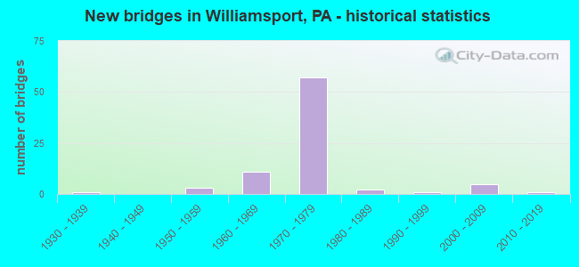
- New bridges - historical statistics
- 11930-1939
- 31950-1959
- 111960-1969
- 571970-1979
- 21980-1989
- 11990-1999
- 52000-2009
- 12010-2019

- Reconstructed bridges - Historical Statistics
- 11950-1959
- 01960-1969
- 11970-1979
- 01980-1989
- 81990-1999
- 22000-2009
- 32010-2019


- Bridge Condition - Deck
- 2.1%Excellent
- 8.3%Very good
- 66.7%Good
- 20.8%Satisfactory
- 2.1%Fair

- Bridge Condition - Superstructure
- 20.4%Very good
- 40.8%Good
- 26.5%Satisfactory
- 12.2%Fair

- Bridge Condition - Substructure
- 2.0%Very good
- 32.7%Good
- 42.9%Satisfactory
- 22.4%Fair

- Bridge Condition - Channel
- 7.4%Very good
- 18.5%Good
- 22.2%Satisfactory
- 29.6%Fair
- 22.2%Poor

- Bridge Condition - Culverts
- 50.0%Good
- 25.0%Satisfactory
- 25.0%Fair
Find on map >> Show street view
Structure Number: 247, Location: 1 MI. E. OF KINGSDALE (Lat: 39.723683, Lng: -77.104189), Route carried "on" structure: State highway , Year Built: 1963, Status: Open, Structure Length: 1.40m (4.59ft), Average Daily Traffic: 778 (year 2022), Truck Traffic: 2%, Average Future Daily Traffic: 1,111 (year 2032), Design Load: H 20, Features Intersected: PINEY CREEK, Facility Carried by Structure: SR 2014
Minimum Vertical Clearance: 30+ m (98+ ft), Kilometerpoint: 8.380, Lanes on structure: 2, Owner: State Highway Agency, Approaching Roadway Width: 5.8m (19.0ft), Skew: 3 degrees, Material/Design: Prestressed concrete, Design/Construction: Box Beam or Girders - Multiple, Number Of Spans In Main Unit: 1, Length of Maximum Span: 12.8m (42.0ft), Curb or Sidewalk Widths: Left: 0.5m (1.6ft), Right: 0.5m (1.6ft), Curb-To-Curb Width: 9.1m (29.9ft), Out-to-Out Width: 10.8m (35.4ft)
Condition: Deck: Fair, Superstructure: Fair, Substructure: Satisfactory, Channel: Fair, Operating Rating: 40.8 metric tons, Method Used To Determine Operating Rating: Load Factor (LF), Inventory Rating: 23.6 metric tons, Method Used To Determine Inventory Rating: Load Factor (LF), Structural Evaluation: Somewhat better than minimum adequacy, Deck Geometry: Equal to present minimum criteria, Waterway Adequacy: Superior to present desirable criteria, Approach Roadway Alignment: Equal to present desirable criteria, Length Of Structure Improvement: 2.00m (6.56ft), Designated Inspection Frequency: Every 24 months, Inspection Date: Febuary 2021, Deck Structure Type: Other, Wearing Surface/Protective System: Wearing Surface: Bituminous, Membrane: Preformed Fabric
Find on map >> Show street view
Structure Number: 24526, Location: CITY OF WILLIAMSPORT (Lat: 41.233386, Lng: -77.042919), Route carried "on" structure: US 15, Year Built: 1974, Status: Open, Structure Length: 17.95m (58.89ft), Average Daily Traffic: 12,702 (year 2021), Truck Traffic: 15%, Average Future Daily Traffic: 18,047 (year 2032), Design Load: HS 20, Features Intersected: NB OVER LYC CK/CK DRAINS
Minimum Vertical Clearance: 30+ m (98+ ft), Kilometerpoint: 16.084, Lanes on structure: 2, Base Highway Network: Yes, Owner: State Highway Agency, Approaching Roadway Width: 11.9m (39.0ft), Skew: 10 degrees, Material/Design: Steel continuous, Design/Construction: Stringer/Multi-beam, Number Of Spans In Main Unit: 4, Number Of Approach Spans: 1, Length of Maximum Span: 42.4m (139.1ft), Curb or Sidewalk Widths: Left: 0.2m (0.7ft), Right: 0.2m (0.7ft), Curb-To-Curb Width: 15.7m (51.5ft), Out-to-Out Width: 16.8m (55.1ft)
Condition: Deck: Good, Superstructure: Good, Substructure: Fair, Channel: Poor, Operating Rating: 65.3 metric tons, Method Used To Determine Operating Rating: Load Factor (LF), Inventory Rating: 39.0 metric tons, Method Used To Determine Inventory Rating: Load Factor (LF), Structural Evaluation: Somewhat better than minimum adequacy, Deck Geometry: Superior to present desirable criteria, Waterway Adequacy: Superior to present desirable criteria, Approach Roadway Alignment: Somewhat better than minimum adequacy, Length Of Structure Improvement: 18.70m (61.35ft), Designated Inspection Frequency: Every 24 months, Inspection Date: June 2020, Bridge Improvement Cost: $42,000, Roadway Improvement Cost: $124,000, Total Project Cost: $569,000, Deck Structure Type: Concrete Cast-file-Place, Wearing Surface/Protective System: Wearing Surface: Epoxy Overlay
Find on map >> Show street view
Structure Number: 24528, Location: WMSPT(NEAR BOWMAN FIELD) (Lat: 41.234492, Lng: -77.044072), Route carried "on" structure: US 15, Year Built: 1974, Status: Open, Structure Length: 4.54m (14.90ft), Average Daily Traffic: 12,702 (year 2021), Truck Traffic: 15%, Average Future Daily Traffic: 18,047 (year 2032), Design Load: HS 20, Features Intersected: SEDACOG LYCO VALLEY RR
Minimum Vertical Clearance: 30+ m (98+ ft), Kilometerpoint: 16.084, Lanes on structure: 3, Base Highway Network: Yes, Owner: State Highway Agency, Approaching Roadway Width: 15.8m (51.8ft), Skew: 13 degrees, Material/Design: Prestressed concrete, Design/Construction: Box Beam or Girders - Single/Spread, Number Of Spans In Main Unit: 3, Length of Maximum Span: 19.8m (65.0ft), Curb or Sidewalk Widths: Left: 0.2m (0.7ft), Right: 0.2m (0.7ft), Curb-To-Curb Width: 17.6m (57.7ft), Out-to-Out Width: 18.8m (61.7ft)
Condition: Deck: Satisfactory, Superstructure: Fair, Substructure: Good, Operating Rating: 69.9 metric tons, Method Used To Determine Operating Rating: Load Factor (LF), Inventory Rating: 37.2 metric tons, Method Used To Determine Inventory Rating: Load Factor (LF), Structural Evaluation: Somewhat better than minimum adequacy, Deck Geometry: Better than present minimum criteria, Underclear: High priority of corrective action, Approach Roadway Alignment: Equal to present desirable criteria, Length Of Structure Improvement: 5.50m (18.04ft), Designated Inspection Frequency: Every 24 months, Inspection Date: August 2020, Deck Structure Type: Concrete Cast-file-Place, Wearing Surface/Protective System: Wearing Surface: Epoxy Overlay, Deck Protection: Epoxy Coated Reinforcing
Find on map >> Show street view
Structure Number: 24529, Location: CITY OF WILLIAMSPORT (Lat: 41.236892, Lng: -77.046556), Route carried "on" structure: US 15, Year Built: 1974, Status: Open, Structure Length: 5.76m (18.90ft), Average Daily Traffic: 12,702 (year 2021), Truck Traffic: 15%, Average Future Daily Traffic: 18,047 (year 2032), Design Load: HS 20, Features Intersected: 3RD ST & SEDA-COG RR
Minimum Vertical Clearance: 30+ m (98+ ft), Kilometerpoint: 16.084, Lanes on structure: 2, Lanes under structure: 2, Base Highway Network: Yes, Owner: State Highway Agency, Approaching Roadway Width: 11.9m (39.0ft), Skew: 12 degrees, Material/Design: Steel continuous, Design/Construction: Stringer/Multi-beam, Number Of Spans In Main Unit: 2, Length of Maximum Span: 28.0m (91.9ft), Curb or Sidewalk Widths: Left: 0.2m (0.7ft), Right: 0.2m (0.7ft), Curb-To-Curb Width: 18.5m (60.7ft), Out-to-Out Width: 19.2m (63.0ft)
Condition: Deck: Good, Superstructure: Satisfactory, Substructure: Good, Operating Rating: 60.8 metric tons, Method Used To Determine Operating Rating: Load Factor (LF), Inventory Rating: 36.3 metric tons, Method Used To Determine Inventory Rating: Load Factor (LF), Structural Evaluation: Equal to present minimum criteria, Deck Geometry: Superior to present desirable criteria, Underclear: Superior to present desirable criteria, Approach Roadway Alignment: Equal to present desirable criteria, Length Of Structure Improvement: 6.70m (21.98ft), Designated Inspection Frequency: Every 24 months, Inspection Date: January 2021, Deck Structure Type: Concrete Cast-file-Place, Wearing Surface/Protective System: Wearing Surface: Monolithic Concrete, Deck Protection: Bituminous
Find on map >> Show street view
Structure Number: 2453, Location: CITY OF WILLIAMSPORT (Lat: 41.237694, Lng: -77.047350), Route carried "on" structure: US 15, Year Built: 1974, Status: Open, Structure Length: 0.73m (2.40ft), Average Daily Traffic: 26,530 (year 2021), Truck Traffic: 14%, Average Future Daily Traffic: 41,863 (year 2032), Design Load: HS 20, Features Intersected: OVER SPRING RUN
Minimum Vertical Clearance: 30+ m (98+ ft), Kilometerpoint: 16.084, Lanes on structure: 4, Base Highway Network: Yes, Owner: State Highway Agency, Approaching Roadway Width: 25.0m (82.0ft), Skew: 35 degrees, Material/Design: Concrete, Design/Construction: Culvert, Number Of Spans In Main Unit: 2, Length of Maximum Span: 3.7m (12.1ft)
Condition: Channel: Satisfactory, Culverts: Good, Operating Rating: 89.8 metric tons, Method Used To Determine Operating Rating: Load Factor (LF), Inventory Rating: 89.8 metric tons, Method Used To Determine Inventory Rating: Load Factor (LF), Structural Evaluation: Better than present minimum criteria, Waterway Adequacy: Superior to present desirable criteria, Approach Roadway Alignment: Equal to present desirable criteria, Length Of Structure Improvement: 1.40m (4.59ft), Designated Inspection Frequency: Every 48 months, Inspection Date: January 2019
Find on map >> Show street view
Structure Number: 24531, Location: CITY OF WILLIAMSPORT (Lat: 41.239361, Lng: -77.000056), Route carried "on" structure: US 15, Year Built: 1974, Status: Open, Structure Length: 17.71m (58.10ft), Average Daily Traffic: 13,828 (year 2021), Truck Traffic: 13%, Average Future Daily Traffic: 19,606 (year 2032), Design Load: HS 20, Features Intersected: SB OVER LYC CK/CK DRAINS
Minimum Vertical Clearance: 30+ m (98+ ft), Kilometerpoint: 16.227, Lanes on structure: 2, Base Highway Network: Yes, Owner: State Highway Agency, Approaching Roadway Width: 7.3m (24.0ft), Skew: 10 degrees, Material/Design: Steel continuous, Design/Construction: Stringer/Multi-beam, Number Of Spans In Main Unit: 4, Number Of Approach Spans: 1, Length of Maximum Span: 42.4m (139.1ft), Curb or Sidewalk Widths: Left: 0.2m (0.7ft), Right: 0.2m (0.7ft), Curb-To-Curb Width: 11.9m (39.0ft), Out-to-Out Width: 13.2m (43.3ft)
Condition: Deck: Good, Superstructure: Good, Substructure: Fair, Channel: Good, Operating Rating: 63.5 metric tons, Method Used To Determine Operating Rating: Load Factor (LF), Inventory Rating: 38.1 metric tons, Method Used To Determine Inventory Rating: Load Factor (LF), Structural Evaluation: Somewhat better than minimum adequacy, Deck Geometry: Equal to present minimum criteria, Waterway Adequacy: Superior to present desirable criteria, Approach Roadway Alignment: Equal to present desirable criteria, Length Of Structure Improvement: 18.40m (60.37ft), Designated Inspection Frequency: Every 24 months, Inspection Date: June 2020, Bridge Improvement Cost: $5,000, Roadway Improvement Cost: $16,000, Total Project Cost: $72,000, Deck Structure Type: Concrete Cast-file-Place, Wearing Surface/Protective System: Wearing Surface: Epoxy Overlay
Find on map >> Show street view
Structure Number: 24532, Location: WMSPT(NEAR BOWMAN FIELD) (Lat: 41.234519, Lng: -77.044383), Route carried "on" structure: US 15, Year Built: 1972, Status: Open, Structure Length: 4.85m (15.91ft), Average Daily Traffic: 13,828 (year 2021), Truck Traffic: 13%, Average Future Daily Traffic: 19,606 (year 2032), Design Load: HS 20, Features Intersected: OVER (S-C)LYCO.VALLEY RR
Minimum Vertical Clearance: 30+ m (98+ ft), Kilometerpoint: 16.227, Lanes on structure: 2, Base Highway Network: Yes, Owner: State Highway Agency, Approaching Roadway Width: 7.3m (24.0ft), Skew: 13 degrees, Material/Design: Prestressed concrete, Design/Construction: Box Beam or Girders - Single/Spread, Number Of Spans In Main Unit: 3, Length of Maximum Span: 20.1m (65.9ft), Curb or Sidewalk Widths: Left: 0.2m (0.7ft), Right: 0.2m (0.7ft), Curb-To-Curb Width: 11.9m (39.0ft), Out-to-Out Width: 13.2m (43.3ft)
Condition: Deck: Good, Superstructure: Satisfactory, Substructure: Satisfactory, Operating Rating: 59.0 metric tons, Method Used To Determine Operating Rating: Load Factor (LF), Inventory Rating: 29.0 metric tons, Method Used To Determine Inventory Rating: Load Factor (LF), Structural Evaluation: Equal to present minimum criteria, Deck Geometry: Equal to present minimum criteria, Underclear: High priority of corrective action, Approach Roadway Alignment: Equal to present desirable criteria, Length Of Structure Improvement: 5.80m (19.03ft), Designated Inspection Frequency: Every 24 months, Inspection Date: August 2020, Bridge Improvement Cost: $11,000, Roadway Improvement Cost: $50,000, Total Project Cost: $147,000, Deck Structure Type: Concrete Cast-file-Place, Wearing Surface/Protective System: Wearing Surface: Epoxy Overlay, Deck Protection: Galvanized Reinforcing
Find on map >> Show street view
Structure Number: 24534, Location: CITY OF WILLIAMSPORT (Lat: 41.236867, Lng: -77.046808), Route carried "on" structure: US 15, Year Built: 1974, Status: Open, Structure Length: 5.55m (18.21ft), Average Daily Traffic: 13,828 (year 2021), Truck Traffic: 13%, Average Future Daily Traffic: 19,606 (year 2032), Design Load: HS 20, Features Intersected: 3RD ST & SEDA-COG RR
Minimum Vertical Clearance: 30+ m (98+ ft), Kilometerpoint: 16.227, Lanes on structure: 3, Lanes under structure: 2, Base Highway Network: Yes, Owner: State Highway Agency, Approaching Roadway Width: 13.1m (43.0ft), Skew: 12 degrees, Material/Design: Steel continuous, Design/Construction: Stringer/Multi-beam, Number Of Spans In Main Unit: 2, Length of Maximum Span: 28.0m (91.9ft), Curb or Sidewalk Widths: Left: 0.2m (0.7ft), Right: 0.2m (0.7ft), Curb-To-Curb Width: 16.1m (52.8ft), Out-to-Out Width: 16.9m (55.4ft)
Condition: Deck: Good, Superstructure: Good, Substructure: Good, Operating Rating: 59.0 metric tons, Method Used To Determine Operating Rating: Load Factor (LF), Inventory Rating: 35.4 metric tons, Method Used To Determine Inventory Rating: Load Factor (LF), Structural Evaluation: Better than present minimum criteria, Deck Geometry: Equal to present minimum criteria, Underclear: Superior to present desirable criteria, Approach Roadway Alignment: Equal to present desirable criteria, Length Of Structure Improvement: 6.50m (21.33ft), Designated Inspection Frequency: Every 24 months, Inspection Date: January 2021, Deck Structure Type: Concrete Cast-file-Place, Wearing Surface/Protective System: Wearing Surface: Monolithic Concrete
Find on map >> Show street view
Structure Number: 24535, Location: CITY OF WILLIAMSPORT (Lat: 41.240308, Lng: -77.049203), Route carried "on" structure: US 15, Year Built: 1974, Status: Open, Structure Length: 2.83m (9.28ft), Average Daily Traffic: 26,530 (year 2021), Truck Traffic: 14%, Average Future Daily Traffic: 37,653 (year 2032), Design Load: HS 20, Features Intersected: OVER W FOURTH ST SR 2014
Minimum Vertical Clearance: 30+ m (98+ ft), Kilometerpoint: 17.093, Lanes on structure: 4, Lanes under structure: 2, Base Highway Network: Yes, Owner: State Highway Agency, Approaching Roadway Width: 25.0m (82.0ft), Skew: 31 degrees, Material/Design: Steel, Design/Construction: Stringer/Multi-beam, Number Of Spans In Main Unit: 1, Length of Maximum Span: 27.4m (89.9ft), Curb or Sidewalk Widths: Left: 0.2m (0.7ft), Right: 0.2m (0.7ft), Curb-To-Curb Width: 27.3m (89.6ft), Out-to-Out Width: 28.0m (91.9ft)
Condition: Deck: Good, Superstructure: Very good, Substructure: Good, Inventory Rating: 66.2 metric tons, Method Used To Determine Inventory Rating: Load Factor (LF), Structural Evaluation: Better than present minimum criteria, Deck Geometry: Superior to present desirable criteria, Underclear: High priority of corrective action, Approach Roadway Alignment: Equal to present desirable criteria, Length Of Structure Improvement: 3.60m (11.81ft), Designated Inspection Frequency: Every 24 months, Inspection Date: January 2021, Bridge Improvement Cost: $43,000, Roadway Improvement Cost: $126,000, Total Project Cost: $579,000, Deck Structure Type: Concrete Cast-file-Place, Wearing Surface/Protective System: Wearing Surface: Latex Concrete, Deck Protection: Galvanized Reinforcing
Find on map >> Show street view
Structure Number: 24537, Location: CITY OF WILLIAMSPORT (Lat: 41.244936, Lng: -77.048872), Route carried "on" structure: US 15, Year Built: 1974, Status: Open, Structure Length: 2.68m (8.79ft), Average Daily Traffic: 26,530 (year 2021), Truck Traffic: 14%, Average Future Daily Traffic: 37,653 (year 2032), Design Load: HS 20, Features Intersected: OVR MEMORIAL AVE SR 3021
Minimum Vertical Clearance: 30+ m (98+ ft), Kilometerpoint: 17.093, Lanes on structure: 4, Lanes under structure: 2, Base Highway Network: Yes, Owner: State Highway Agency, Approaching Roadway Width: 25.3m (83.0ft), Skew: 30 degrees, Material/Design: Steel, Design/Construction: Stringer/Multi-beam, Number Of Spans In Main Unit: 1, Length of Maximum Span: 24.1m (79.1ft), Curb or Sidewalk Widths: Left: 0.2m (0.7ft), Right: 0.2m (0.7ft), Curb-To-Curb Width: 34.6m (113.5ft), Out-to-Out Width: 35.7m (117.1ft)
Condition: Deck: Good, Superstructure: Very good, Substructure: Good, Operating Rating: 72.6 metric tons, Method Used To Determine Operating Rating: Load Factor (LF), Inventory Rating: 43.5 metric tons, Method Used To Determine Inventory Rating: Load Factor (LF), Structural Evaluation: Better than present minimum criteria, Deck Geometry: Superior to present desirable criteria, Underclear: High priority of corrective action, Approach Roadway Alignment: Equal to present desirable criteria, Length Of Structure Improvement: 3.40m (11.15ft), Designated Inspection Frequency: Every 48 months, Inspection Date: January 2019, Bridge Improvement Cost: $33,000, Roadway Improvement Cost: $96,000, Total Project Cost: $441,000, Deck Structure Type: Concrete Cast-file-Place, Wearing Surface/Protective System: Wearing Surface: Bituminous, Membrane: Preformed Fabric
Find on map >> Show street view
Structure Number: 24615, Location: CITY OF WILLIAMSPORT (Lat: 41.231117, Lng: -77.019228), Route carried "on" structure: Interstate 180, Year Built: 1972, Status: Open, Structure Length: 2.87m (9.42ft), Average Daily Traffic: 22,121 (year 2021), Truck Traffic: 14%, Average Future Daily Traffic: 21,276 (year 2032), Design Load: HL 93, Features Intersected: OVER MAYNARD STREET
Minimum Vertical Clearance: 30+ m (98+ ft), Kilometerpoint: 1.413, Lanes on structure: 2, Lanes under structure: 2, Base Highway Network: Yes, Owner: State Highway Agency, Approaching Roadway Width: 11.6m (38.1ft), Skew: 10 degrees, Material/Design: Prestressed concrete, Design/Construction: Stringer/Multi-beam, Number Of Spans In Main Unit: 1, Length of Maximum Span: 27.4m (89.9ft), Curb or Sidewalk Widths: Left: 0.2m (0.7ft), Right: 0.2m (0.7ft), Curb-To-Curb Width: 12.4m (40.7ft), Out-to-Out Width: 13.2m (43.3ft)
Condition: Deck: Very good, Superstructure: Satisfactory, Substructure: Satisfactory, Operating Rating: 79.8 metric tons, Method Used To Determine Operating Rating: Load and Resistance Factor (LRFR), Inventory Rating: 42.6 metric tons, Method Used To Determine Inventory Rating: Load and Resistance Factor (LRFR), Structural Evaluation: Equal to present minimum criteria, Deck Geometry: Better than present minimum criteria, Underclear: Equal to present minimum criteria, Approach Roadway Alignment: Equal to present desirable criteria, Length Of Structure Improvement: 2.90m (9.51ft), Designated Inspection Frequency: Every 48 months, Inspection Date: January 2019, Deck Structure Type: Concrete Cast-file-Place, Wearing Surface/Protective System: Wearing Surface: Epoxy Overlay
Find on map >> Show street view
Structure Number: 24616, Location: CITY OF WILLIAMSPORT (Lat: 41.231289, Lng: -77.019228), Route carried "on" structure: Interstate 180, Year Built: 1972, Status: Open, Structure Length: 2.87m (9.42ft), Average Daily Traffic: 21,716 (year 2021), Truck Traffic: 16%, Average Future Daily Traffic: 27,120 (year 2032), Design Load: HS 20, Features Intersected: OVER MAYNARD STREET
Minimum Vertical Clearance: 30+ m (98+ ft), Kilometerpoint: 1.424, Lanes on structure: 2, Lanes under structure: 2, Base Highway Network: Yes, Owner: State Highway Agency, Approaching Roadway Width: 11.6m (38.1ft), Skew: 10 degrees, Material/Design: Prestressed concrete, Design/Construction: Stringer/Multi-beam, Number Of Spans In Main Unit: 1, Length of Maximum Span: 27.4m (89.9ft), Curb or Sidewalk Widths: Left: 0.2m (0.7ft), Right: 0.2m (0.7ft), Curb-To-Curb Width: 12.4m (40.7ft), Out-to-Out Width: 13.2m (43.3ft)
Condition: Deck: Very good, Superstructure: Good, Substructure: Satisfactory, Inventory Rating: 22.7 metric tons, Method Used To Determine Inventory Rating: Load Factor (LF), Structural Evaluation: Somewhat better than minimum adequacy, Deck Geometry: Better than present minimum criteria, Underclear: Equal to present minimum criteria, Approach Roadway Alignment: Equal to present desirable criteria, Length Of Structure Improvement: 3.70m (12.14ft), Designated Inspection Frequency: Every 24 months, Inspection Date: January 2021, Bridge Improvement Cost: $9,000, Roadway Improvement Cost: $38,000, Total Project Cost: $124,000, Deck Structure Type: Concrete Cast-file-Place, Wearing Surface/Protective System: Wearing Surface: Bituminous, Membrane: Preformed Fabric
Find on map >> Show street view
Structure Number: 24617, Location: CITY OF WILLIAMSPORT (Lat: 41.233306, Lng: -77.011997), Route carried "on" structure: Interstate 180, Year Built: 1971, Status: Open, Structure Length: 5.70m (18.70ft), Average Daily Traffic: 43,837 (year 2021), Truck Traffic: 15%, Average Future Daily Traffic: 53,359 (year 2032), Design Load: HL 93, Features Intersected: OVER (S-C)LYCO.VALLEY RR
Minimum Vertical Clearance: 30+ m (98+ ft), Kilometerpoint: 2.206, Lanes on structure: 4, Base Highway Network: Yes, Owner: State Highway Agency, Approaching Roadway Width: 35.1m (115.2ft), Skew: 37 degrees, Material/Design: Prestressed concrete, Design/Construction: Box Beam or Girders - Multiple, Number Of Spans In Main Unit: 1, Length of Maximum Span: 18.0m (59.1ft), Curb or Sidewalk Widths: Left: 0.2m (0.7ft), Right: 0.2m (0.7ft), Curb-To-Curb Width: 35.4m (116.1ft), Out-to-Out Width: 36.6m (120.1ft)
Condition: Superstructure: Fair, Substructure: Satisfactory, Inventory Rating: 34.5 metric tons, Method Used To Determine Inventory Rating: Load Factor (LF), Structural Evaluation: Somewhat better than minimum adequacy, Deck Geometry: Superior to present desirable criteria, Underclear: High priority of corrective action, Approach Roadway Alignment: Equal to present desirable criteria, Length Of Structure Improvement: 6.70m (21.98ft), Designated Inspection Frequency: Every 24 months, Inspection Date: January 2021, Total Project Cost: $1,000,000
Find on map >> Show street view
Structure Number: 24619, Location: CITY OF WILLIAMSPORT (Lat: 41.235225, Lng: -77.007578), Route carried "on" structure: Interstate 180, Year Built: 1971, Status: Open, Structure Length: 0.64m (2.10ft), Average Daily Traffic: 49,420 (year 2021), Truck Traffic: 11%, Average Future Daily Traffic: 59,724 (year 2032), Design Load: HS 20, Features Intersected: OVER GRAFIUS RUN
Minimum Vertical Clearance: 30+ m (98+ ft), Kilometerpoint: 2.206, Lanes on structure: 6, Base Highway Network: Yes, Owner: State Highway Agency, Approaching Roadway Width: 31.7m (104.0ft), Skew: 25 degrees, Material/Design: Concrete, Design/Construction: Culvert, Number Of Spans In Main Unit: 1, Length of Maximum Span: 6.4m (21.0ft)
Condition: Channel: Good, Culverts: Good, Operating Rating: 89.8 metric tons, Method Used To Determine Operating Rating: Load Factor (LF), Inventory Rating: 89.8 metric tons, Method Used To Determine Inventory Rating: Load Factor (LF), Structural Evaluation: Better than present minimum criteria, Waterway Adequacy: Superior to present desirable criteria, Approach Roadway Alignment: Equal to present desirable criteria, Length Of Structure Improvement: 0.60m (1.97ft), Designated Inspection Frequency: Every 48 months, Inspection Date: January 2019
Find on map >> Show street view
Structure Number: 24621, Location: CITY OF WILLIAMSPORT (Lat: 41.235808, Lng: -77.006053), Route carried "on" structure: Interstate 180, Year Built: 1972, Status: Open, Structure Length: 3.35m (10.99ft), Average Daily Traffic: 21,272 (year 2021), Truck Traffic: 12%, Average Future Daily Traffic: 24,505 (year 2032), Design Load: HS 20, Features Intersected: OVER RAMP A&B (HEPBURN )
Minimum Vertical Clearance: 30+ m (98+ ft), Kilometerpoint: 3.038, Lanes on structure: 2, Lanes under structure: 2, Base Highway Network: Yes, Owner: State Highway Agency, Approaching Roadway Width: 14.6m (47.9ft), Skew: 13 degrees, Material/Design: Steel, Design/Construction: Stringer/Multi-beam, Number Of Spans In Main Unit: 1, Length of Maximum Span: 32.3m (106.0ft), Curb-To-Curb Width: 12.4m (40.7ft), Out-to-Out Width: 13.2m (43.3ft)
Condition: Deck: Good, Superstructure: Very good, Substructure: Satisfactory, Operating Rating: 91.6 metric tons, Method Used To Determine Operating Rating: Load Factor (LF), Inventory Rating: 54.4 metric tons, Method Used To Determine Inventory Rating: Load Factor (LF), Structural Evaluation: Equal to present minimum criteria, Deck Geometry: Better than present minimum criteria, Underclear: High priority of corrective action, Approach Roadway Alignment: Equal to present desirable criteria, Length Of Structure Improvement: 4.20m (13.78ft), Designated Inspection Frequency: Every 24 months, Inspection Date: January 2021, Bridge Improvement Cost: $10,000, Roadway Improvement Cost: $36,000, Total Project Cost: $133,000, Deck Structure Type: Concrete Cast-file-Place, Wearing Surface/Protective System: Wearing Surface: Bituminous, Membrane: Preformed Fabric
Find on map >> Show street view
Structure Number: 24622, Location: CITY OF WILLIAMSPORT (Lat: 41.236000, Lng: -77.006022), Route carried "on" structure: Interstate 180, Year Built: 1972, Year Reconstructed: 2007, Status: Open, Structure Length: 3.35m (10.99ft), Average Daily Traffic: 21,456 (year 2021), Truck Traffic: 12%, Average Future Daily Traffic: 24,496 (year 2032), Design Load: HL 93, Features Intersected: OVER RAMP A&B(HEPBURN ST
Minimum Vertical Clearance: 30+ m (98+ ft), Kilometerpoint: 3.026, Lanes on structure: 2, Lanes under structure: 4, Base Highway Network: Yes, Owner: State Highway Agency, Approaching Roadway Width: 12.2m (40.0ft), Skew: 13 degrees, Material/Design: Prestressed concrete, Design/Construction: Box Beam or Girders - Multiple, Number Of Spans In Main Unit: 1, Length of Maximum Span: 32.3m (106.0ft), Curb or Sidewalk Widths: Left: 0.2m (0.7ft), Right: 0.2m (0.7ft), Curb-To-Curb Width: 12.4m (40.7ft), Out-to-Out Width: 13.2m (43.3ft)
Condition: Deck: Good, Superstructure: Very good, Substructure: Good, Operating Rating: 75.3 metric tons, Method Used To Determine Operating Rating: Load and Resistance Factor (LRFR), Inventory Rating: 36.3 metric tons, Method Used To Determine Inventory Rating: Load and Resistance Factor (LRFR), Structural Evaluation: Better than present minimum criteria, Deck Geometry: Better than present minimum criteria, Underclear: Meets minimum limits, Approach Roadway Alignment: Equal to present desirable criteria, Length Of Structure Improvement: 4.20m (13.78ft), Designated Inspection Frequency: Every 24 months, Inspection Date: January 2021, Bridge Improvement Cost: $80,000, Roadway Improvement Cost: $236,000, Total Project Cost: $1,080,000, Deck Structure Type: Concrete Cast-file-Place, Wearing Surface/Protective System: Wearing Surface: Epoxy Overlay, Deck Protection: Epoxy Coated Reinforcing
Find on map >> Show street view
Structure Number: 24624, Location: OVER BASIN STREET (Lat: 41.241742, Lng: -76.994714), Route carried "on" structure: Interstate 180, Year Built: 1978, Status: Open, Structure Length: 3.99m (13.09ft), Average Daily Traffic: 22,698 (year 2022), Truck Traffic: 18%, Average Future Daily Traffic: 24,505 (year 2032), Design Load: HS 20, Features Intersected: LR 289 SPUR'C(BASIN ST)
Minimum Vertical Clearance: 30+ m (98+ ft), Kilometerpoint: 3.843, Lanes on structure: 3, Lanes under structure: 4, Base Highway Network: Yes, Owner: State Highway Agency, Approaching Roadway Width: 11.6m (38.1ft), Skew: 14 degrees, Material/Design: Steel, Design/Construction: Stringer/Multi-beam, Number Of Spans In Main Unit: 1, Length of Maximum Span: 38.1m (125.0ft), Curb or Sidewalk Widths: Left: 0.2m (0.7ft), Right: 0.2m (0.7ft), Curb-To-Curb Width: 16.5m (54.1ft), Out-to-Out Width: 17.4m (57.1ft)
Condition: Deck: Good, Superstructure: Very good, Substructure: Good, Inventory Rating: 61.7 metric tons, Method Used To Determine Inventory Rating: Load Factor (LF), Structural Evaluation: Better than present minimum criteria, Deck Geometry: Equal to present minimum criteria, Underclear: Superior to present desirable criteria, Approach Roadway Alignment: Equal to present desirable criteria, Length Of Structure Improvement: 4.80m (15.75ft), Designated Inspection Frequency: Every 48 months, Inspection Date: January 2019, Bridge Improvement Cost: $18,000, Roadway Improvement Cost: $53,000, Total Project Cost: $243,000, Deck Structure Type: Concrete Cast-file-Place, Wearing Surface/Protective System: Wearing Surface: Epoxy Overlay, Deck Protection: Epoxy Coated Reinforcing
Find on map >> Show street view
Structure Number: 24625, Location: OVER BASIN STREET (Lat: 41.241736, Lng: -76.995006), Route carried "on" structure: Interstate 180, Year Built: 1978, Status: Open, Structure Length: 3.99m (13.09ft), Average Daily Traffic: 23,626 (year 2022), Truck Traffic: 17%, Average Future Daily Traffic: 24,496 (year 2032), Design Load: HS 20, Features Intersected: LR 289 SPUR'C(BASIN ST)
Minimum Vertical Clearance: 30+ m (98+ ft), Kilometerpoint: 3.832, Lanes on structure: 2, Lanes under structure: 4, Base Highway Network: Yes, Owner: State Highway Agency, Approaching Roadway Width: 16.5m (54.1ft), Skew: 14 degrees, Material/Design: Steel, Design/Construction: Stringer/Multi-beam, Number Of Spans In Main Unit: 1, Length of Maximum Span: 38.1m (125.0ft), Curb or Sidewalk Widths: Left: 0.2m (0.7ft), Right: 0.2m (0.7ft), Curb-To-Curb Width: 16.5m (54.1ft), Out-to-Out Width: 17.4m (57.1ft)
Condition: Deck: Good, Superstructure: Very good, Substructure: Satisfactory, Inventory Rating: 61.7 metric tons, Method Used To Determine Inventory Rating: Load Factor (LF), Structural Evaluation: Equal to present minimum criteria, Deck Geometry: Superior to present desirable criteria, Underclear: Equal to present minimum criteria, Approach Roadway Alignment: Equal to present desirable criteria, Length Of Structure Improvement: 4.00m (13.12ft), Designated Inspection Frequency: Every 48 months, Inspection Date: January 2019, Deck Structure Type: Concrete Cast-file-Place, Wearing Surface/Protective System: Wearing Surface: Epoxy Overlay, Deck Protection: Epoxy Coated Reinforcing
Find on map >> Show street view
Structure Number: 24693, Location: VILLAGE OF LINDEN (Lat: 41.232119, Lng: -77.134014), Route carried "on" structure: US 220, Year Built: 1936, Year Reconstructed: 1959, Status: Open, Structure Length: 0.73m (2.40ft), Average Daily Traffic: 20,771 (year 2021), Truck Traffic: 12%, Average Future Daily Traffic: 32,793 (year 2032), Design Load: HS 20, Features Intersected: OVER QUENSHUKENY RUN
Minimum Vertical Clearance: 30+ m (98+ ft), Kilometerpoint: 13.716, Lanes on structure: 4, Base Highway Network: Yes, Owner: State Highway Agency, Approaching Roadway Width: 23.8m (78.1ft), Skew: 20 degrees, Material/Design: Concrete, Design/Construction: Culvert, Number Of Spans In Main Unit: 1, Length of Maximum Span: 7.3m (24.0ft)
Condition: Channel: Fair, Culverts: Fair, Operating Rating: 54.4 metric tons, Method Used To Determine Operating Rating: Field evaluation and documented engineering judgment, Inventory Rating: 32.7 metric tons, Method Used To Determine Inventory Rating: Field evaluation and documented engineering judgment, Structural Evaluation: Somewhat better than minimum adequacy, Waterway Adequacy: Superior to present desirable criteria, Approach Roadway Alignment: Equal to present desirable criteria, Length Of Structure Improvement: 0.70m (2.30ft), Designated Inspection Frequency: Every 24 months, Inspection Date: January 2021, Total Project Cost: $316,000
Find on map >> Show street view
Structure Number: 24694, Location: 3 MI WEST NEWBERRY (Lat: 41.230767, Lng: -77.107653), Route carried "on" structure: US 220, Year Built: 1971, Year Reconstructed: 2001, Status: Open, Structure Length: 5.39m (17.68ft), Average Daily Traffic: 7,459 (year 2020), Truck Traffic: 15%, Average Future Daily Traffic: 13,525 (year 2032), Design Load: HS 20, Features Intersected: OVER RAMP A-1
Minimum Vertical Clearance: 30+ m (98+ ft), Kilometerpoint: 16.819, Lanes on structure: 2, Lanes under structure: 1, Base Highway Network: Yes, Owner: State Highway Agency, Approaching Roadway Width: 11.6m (38.1ft), Skew: 12 degrees, Material/Design: Prestressed concrete, Design/Construction: Stringer/Multi-beam, Number Of Spans In Main Unit: 3, Length of Maximum Span: 26.8m (87.9ft), Curb-To-Curb Width: 12.7m (41.7ft), Out-to-Out Width: 13.2m (43.3ft)
Condition: Deck: Satisfactory, Superstructure: Fair, Substructure: Fair, Operating Rating: 63.5 metric tons, Method Used To Determine Operating Rating: Load Factor (LF), Inventory Rating: 30.8 metric tons, Method Used To Determine Inventory Rating: Load Factor (LF), Structural Evaluation: Somewhat better than minimum adequacy, Deck Geometry: Better than present minimum criteria, Underclear: Meets minimum limits, Approach Roadway Alignment: Equal to present desirable criteria, Length Of Structure Improvement: 6.30m (20.67ft), Designated Inspection Frequency: Every 24 months, Inspection Date: June 2020, Bridge Improvement Cost: $29,000, Roadway Improvement Cost: $85,000, Total Project Cost: $389,000, Deck Structure Type: Concrete Cast-file-Place, Wearing Surface/Protective System: Wearing Surface: Bituminous, Membrane: Preformed Fabric
Find on map >> Show street view
Structure Number: 24695, Location: 2.5 MI WEST NEWBERRY (Lat: 41.230219, Lng: -77.105533), Route carried "on" structure: US 220, Year Built: 1971, Year Reconstructed: 2001, Status: Open, Structure Length: 2.71m (8.89ft), Average Daily Traffic: 7,459 (year 2020), Truck Traffic: 15%, Average Future Daily Traffic: 13,525 (year 2032), Design Load: HS 20, Features Intersected: OVER T-331
Minimum Vertical Clearance: 30+ m (98+ ft), Kilometerpoint: 16.819, Lanes on structure: 2, Lanes under structure: 2, Base Highway Network: Yes, Owner: State Highway Agency, Approaching Roadway Width: 11.6m (38.1ft), Skew: 11 degrees, Material/Design: Prestressed concrete, Design/Construction: Stringer/Multi-beam, Number Of Spans In Main Unit: 1, Length of Maximum Span: 25.6m (84.0ft), Curb-To-Curb Width: 12.0m (39.4ft), Out-to-Out Width: 13.2m (43.3ft)
Condition: Deck: Good, Superstructure: Good, Substructure: Fair, Operating Rating: 72.6 metric tons, Method Used To Determine Operating Rating: Load Factor (LF), Inventory Rating: 30.8 metric tons, Method Used To Determine Inventory Rating: Load Factor (LF), Structural Evaluation: Somewhat better than minimum adequacy, Deck Geometry: Equal to present minimum criteria, Underclear: Better than present minimum criteria, Approach Roadway Alignment: Equal to present desirable criteria, Length Of Structure Improvement: 3.50m (11.48ft), Designated Inspection Frequency: Every 24 months, Inspection Date: January 2021, Bridge Improvement Cost: $9,000, Roadway Improvement Cost: $38,000, Total Project Cost: $119,000, Deck Structure Type: Concrete Cast-file-Place, Wearing Surface/Protective System: Wearing Surface: Bituminous, Membrane: Preformed Fabric
Find on map >> Show street view
Structure Number: 24696, Location: 1 MI W OF WILLIAMSPORT (Lat: 41.229553, Lng: -77.103644), Route carried "on" structure: US 220, Year Built: 1971, Year Reconstructed: 2001, Status: Open, Structure Length: 8.93m (29.30ft), Average Daily Traffic: 7,459 (year 2020), Truck Traffic: 15%, Average Future Daily Traffic: 16,680 (year 2032), Design Load: HS 20, Features Intersected: OVER SEDA-COG RR
Minimum Vertical Clearance: 30+ m (98+ ft), Kilometerpoint: 16.819, Lanes on structure: 2, Base Highway Network: Yes, Owner: State Highway Agency, Approaching Roadway Width: 11.6m (38.1ft), Skew: 15 degrees, Material/Design: Steel continuous, Design/Construction: Stringer/Multi-beam, Number Of Spans In Main Unit: 3, Length of Maximum Span: 37.2m (122.0ft), Curb-To-Curb Width: 12.4m (40.7ft), Out-to-Out Width: 13.2m (43.3ft)
Condition: Deck: Good, Superstructure: Good, Substructure: Satisfactory, Operating Rating: 45.4 metric tons, Method Used To Determine Operating Rating: Load Factor (LF), Inventory Rating: 27.2 metric tons, Method Used To Determine Inventory Rating: Load Factor (LF), Structural Evaluation: Equal to present minimum criteria, Deck Geometry: Better than present minimum criteria, Underclear: High priority of corrective action, Approach Roadway Alignment: Equal to present desirable criteria, Length Of Structure Improvement: 9.90m (32.48ft), Designated Inspection Frequency: Every 24 months, Inspection Date: April 2021, Bridge Improvement Cost: $32,000, Roadway Improvement Cost: $94,000, Total Project Cost: $432,000, Deck Structure Type: Concrete Cast-file-Place, Wearing Surface/Protective System: Wearing Surface: Epoxy Overlay
Find on map >> Show street view
Structure Number: 24697, Location: 3 MI WEST NEWBERRY (Lat: 41.230911, Lng: -77.107531), Route carried "on" structure: US 220, Year Built: 1971, Year Reconstructed: 2001, Status: Open, Structure Length: 5.09m (16.70ft), Average Daily Traffic: 8,037 (year 2020), Truck Traffic: 16%, Average Future Daily Traffic: 17,033 (year 2032), Design Load: HS 25 or greater, Features Intersected: OVER RAMP A-1
Minimum Vertical Clearance: 30+ m (98+ ft), Kilometerpoint: 16.874, Lanes on structure: 2, Lanes under structure: 1, Base Highway Network: Yes, Owner: State Highway Agency, Approaching Roadway Width: 11.6m (38.1ft), Skew: 12 degrees, Material/Design: Prestressed concrete, Design/Construction: Stringer/Multi-beam, Number Of Spans In Main Unit: 3, Length of Maximum Span: 26.8m (87.9ft), Curb-To-Curb Width: 12.7m (41.7ft), Out-to-Out Width: 13.2m (43.3ft)
Condition: Deck: Good, Superstructure: Fair, Substructure: Fair, Operating Rating: 79.8 metric tons, Method Used To Determine Operating Rating: Load Factor (LF), Inventory Rating: 47.2 metric tons, Method Used To Determine Inventory Rating: Load Factor (LF), Structural Evaluation: Somewhat better than minimum adequacy, Deck Geometry: Better than present minimum criteria, Underclear: Meets minimum limits, Approach Roadway Alignment: Equal to present desirable criteria, Length Of Structure Improvement: 5.40m (17.72ft), Designated Inspection Frequency: Every 24 months, Inspection Date: June 2020, Bridge Improvement Cost: $38,000, Roadway Improvement Cost: $112,000, Total Project Cost: $513,000, Deck Structure Type: Concrete Cast-file-Place, Wearing Surface/Protective System: Wearing Surface: Bituminous, Membrane: Preformed Fabric
Find on map >> Show street view
Structure Number: 24698, Location: 2.5 MI WEST NEWBERRY (Lat: 41.230375, Lng: -77.105467), Route carried "on" structure: US 220, Year Built: 1971, Year Reconstructed: 2001, Status: Open, Structure Length: 2.71m (8.89ft), Average Daily Traffic: 8,037 (year 2020), Truck Traffic: 16%, Average Future Daily Traffic: 13,811 (year 2032), Design Load: HS 20, Features Intersected: OVER T-331
Minimum Vertical Clearance: 30+ m (98+ ft), Kilometerpoint: 16.874, Lanes on structure: 2, Lanes under structure: 2, Base Highway Network: Yes, Owner: State Highway Agency, Approaching Roadway Width: 11.6m (38.1ft), Skew: 10 degrees, Material/Design: Prestressed concrete, Design/Construction: Stringer/Multi-beam, Number Of Spans In Main Unit: 1, Length of Maximum Span: 25.6m (84.0ft), Curb-To-Curb Width: 12.0m (39.4ft), Out-to-Out Width: 13.2m (43.3ft)
Condition: Deck: Good, Superstructure: Good, Substructure: Fair, Operating Rating: 72.6 metric tons, Method Used To Determine Operating Rating: Load Factor (LF), Inventory Rating: 30.8 metric tons, Method Used To Determine Inventory Rating: Load Factor (LF), Structural Evaluation: Somewhat better than minimum adequacy, Deck Geometry: Equal to present minimum criteria, Underclear: Superior to present desirable criteria, Approach Roadway Alignment: Equal to present desirable criteria, Length Of Structure Improvement: 3.50m (11.48ft), Designated Inspection Frequency: Every 24 months, Inspection Date: January 2021, Bridge Improvement Cost: $9,000, Roadway Improvement Cost: $38,000, Total Project Cost: $119,000, Deck Structure Type: Concrete Cast-file-Place, Wearing Surface/Protective System: Wearing Surface: Bituminous, Membrane: Preformed Fabric
Find on map >> Show street view
Structure Number: 24699, Location: 1 MI W OF WILLIAMSPORT (Lat: 41.229583, Lng: -77.103242), Route carried "on" structure: US 220, Year Built: 1971, Year Reconstructed: 2001, Status: Open, Structure Length: 8.56m (28.08ft), Average Daily Traffic: 8,037 (year 2020), Truck Traffic: 16%, Average Future Daily Traffic: 13,811 (year 2032), Design Load: HS 20, Features Intersected: OVER SEDA-COG RR
Minimum Vertical Clearance: 30+ m (98+ ft), Kilometerpoint: 16.874, Lanes on structure: 2, Base Highway Network: Yes, Owner: State Highway Agency, Approaching Roadway Width: 11.6m (38.1ft), Skew: 15 degrees, Material/Design: Steel continuous, Design/Construction: Stringer/Multi-beam, Number Of Spans In Main Unit: 3, Length of Maximum Span: 36.3m (119.1ft), Curb or Sidewalk Widths: Left: 0.2m (0.7ft), Right: 0.2m (0.7ft), Curb-To-Curb Width: 11.9m (39.0ft), Out-to-Out Width: 13.2m (43.3ft)
Condition: Deck: Good, Superstructure: Good, Substructure: Satisfactory, Operating Rating: 49.9 metric tons, Method Used To Determine Operating Rating: Load Factor (LF), Inventory Rating: 29.9 metric tons, Method Used To Determine Inventory Rating: Load Factor (LF), Structural Evaluation: Equal to present minimum criteria, Deck Geometry: Equal to present minimum criteria, Underclear: High priority of corrective action, Approach Roadway Alignment: Equal to present desirable criteria, Length Of Structure Improvement: 8.60m (28.22ft), Designated Inspection Frequency: Every 24 months, Inspection Date: April 2021, Deck Structure Type: Concrete Cast-file-Place, Wearing Surface/Protective System: Wearing Surface: Epoxy Overlay
Find on map >> Show street view
Structure Number: 247, Location: 0.5 MI W OF WILLIAMSPORT (Lat: 41.225400, Lng: -77.088189), Route carried "on" structure: US 220, Year Built: 1971, Status: Open, Structure Length: 0.73m (2.40ft), Average Daily Traffic: 15,496 (year 2020), Truck Traffic: 15%, Average Future Daily Traffic: 27,336 (year 2032), Design Load: HS 20, Features Intersected: OVER DAUGHERTY@S RUN
Minimum Vertical Clearance: 30+ m (98+ ft), Kilometerpoint: 18.425, Lanes on structure: 4, Base Highway Network: Yes, Owner: State Highway Agency, Approaching Roadway Width: 23.2m (76.1ft), Skew: 20 degrees, Material/Design: Concrete, Design/Construction: Culvert, Number Of Spans In Main Unit: 1, Length of Maximum Span: 7.3m (24.0ft)
Condition: Channel: Fair, Culverts: Satisfactory, Operating Rating: 64.4 metric tons, Method Used To Determine Operating Rating: Load Factor (LF), Inventory Rating: 38.1 metric tons, Method Used To Determine Inventory Rating: Load Factor (LF), Structural Evaluation: Equal to present minimum criteria, Waterway Adequacy: Superior to present desirable criteria, Approach Roadway Alignment: Equal to present desirable criteria, Length Of Structure Improvement: 0.70m (2.30ft), Designated Inspection Frequency: Every 24 months, Inspection Date: January 2021
Find on map >> Show street view
Structure Number: 24701, Location: CITY OF WILLIAMSPORT (Lat: 41.223589, Lng: -77.061736), Route carried "on" structure: State highway , Year Built: 1971, Year Reconstructed: 2001, Status: Open, Structure Length: 6.89m (22.60ft), Average Daily Traffic: 3,289 (year 2021), Truck Traffic: 16%, Average Future Daily Traffic: 6,355 (year 2032), Design Load: HS 20, Features Intersected: US 220 NB AND SB, Facility Carried by Structure: REACH RD OVR 220
Minimum Vertical Clearance: 30+ m (98+ ft), Kilometerpoint: 0.000, Lanes on structure: 2, Lanes under structure: 8, Owner: State Highway Agency, Approaching Roadway Width: 14.0m (45.9ft), Material/Design: Prestressed concrete, Design/Construction: Box Beam or Girders - Single/Spread, Number Of Spans In Main Unit: 4, Length of Maximum Span: 22.3m (73.2ft), Curb or Sidewalk Widths: Left: 0.2m (0.7ft), Right: 0.2m (0.7ft), Curb-To-Curb Width: 14.1m (46.3ft), Out-to-Out Width: 14.6m (47.9ft)
Condition: Deck: Satisfactory, Superstructure: Satisfactory, Substructure: Fair, Operating Rating: 65.3 metric tons, Method Used To Determine Operating Rating: Load Factor (LF), Inventory Rating: 33.6 metric tons, Method Used To Determine Inventory Rating: Load Factor (LF), Structural Evaluation: Somewhat better than minimum adequacy, Deck Geometry: Superior to present desirable criteria, Underclear: High priority of corrective action, Approach Roadway Alignment: Equal to present desirable criteria, Length Of Structure Improvement: 6.90m (22.64ft), Designated Inspection Frequency: Every 24 months, Inspection Date: January 2021, Bridge Improvement Cost: $86,000, Roadway Improvement Cost: $252,000, Total Project Cost: $1,156,000, Deck Structure Type: Concrete Cast-file-Place, Wearing Surface/Protective System: Wearing Surface: Monolithic Concrete, Deck Protection: Epoxy Coated Reinforcing
Find on map >> Show street view
Structure Number: 24703, Location: CITY OF WILLIAMSPORT (Lat: 41.228792, Lng: -77.046322), Route carried "on" structure: US 220, Year Built: 1972, Status: Open, Structure Length: 3.93m (12.89ft), Average Daily Traffic: 12,033 (year 2022), Truck Traffic: 12%, Average Future Daily Traffic: 18,172 (year 2032), Design Load: HS 20, Features Intersected: OVER ARCH STREET
Minimum Vertical Clearance: 30+ m (98+ ft), Kilometerpoint: 22.293, Lanes on structure: 2, Lanes under structure: 2, Base Highway Network: Yes, Owner: State Highway Agency, Approaching Roadway Width: 11.6m (38.1ft), Skew: 11 degrees, Material/Design: Prestressed concrete, Design/Construction: Box Beam or Girders - Single/Spread, Number Of Spans In Main Unit: 3, Length of Maximum Span: 17.4m (57.1ft), Curb or Sidewalk Widths: Left: 0.2m (0.7ft), Right: 0.2m (0.7ft), Curb-To-Curb Width: 11.9m (39.0ft), Out-to-Out Width: 13.2m (43.3ft)
Condition: Deck: Good, Superstructure: Satisfactory, Substructure: Satisfactory, Operating Rating: 63.5 metric tons, Method Used To Determine Operating Rating: Load Factor (LF), Inventory Rating: 37.2 metric tons, Method Used To Determine Inventory Rating: Load Factor (LF), Structural Evaluation: Equal to present minimum criteria, Deck Geometry: Equal to present minimum criteria, Underclear: Superior to present desirable criteria, Approach Roadway Alignment: Equal to present desirable criteria, Length Of Structure Improvement: 4.80m (15.75ft), Designated Inspection Frequency: Every 24 months, Inspection Date: January 2021, Bridge Improvement Cost: $27,000, Roadway Improvement Cost: $78,000, Total Project Cost: $359,000, Deck Structure Type: Concrete Cast-file-Place, Wearing Surface/Protective System: Wearing Surface: Epoxy Overlay, Deck Protection: Epoxy Coated Reinforcing
Find on map >> Show street view
Structure Number: 24704, Location: CITY OF WILLIAMSPORT (Lat: 41.230744, Lng: -77.042767), Route carried "on" structure: US 220, Year Built: 1974, Status: Open, Structure Length: 11.86m (38.91ft), Average Daily Traffic: 12,033 (year 2022), Truck Traffic: 12%, Average Future Daily Traffic: 18,006 (year 2032), Design Load: HS 20, Features Intersected: OVER LYCOMING CREEK
Minimum Vertical Clearance: 30+ m (98+ ft), Kilometerpoint: 22.293, Lanes on structure: 2, Base Highway Network: Yes, Owner: State Highway Agency, Approaching Roadway Width: 11.6m (38.1ft), Skew: 10 degrees, Material/Design: Prestressed concrete, Design/Construction: Stringer/Multi-beam, Number Of Spans In Main Unit: 4, Length of Maximum Span: 29.0m (95.1ft), Curb or Sidewalk Widths: Left: 0.2m (0.7ft), Right: 0.2m (0.7ft), Curb-To-Curb Width: 16.1m (52.8ft), Out-to-Out Width: 16.8m (55.1ft)
Condition: Deck: Good, Superstructure: Good, Substructure: Satisfactory, Channel: Poor, Operating Rating: 95.3 metric tons, Method Used To Determine Operating Rating: Load Factor (LF), Inventory Rating: 34.5 metric tons, Method Used To Determine Inventory Rating: Load Factor (LF), Structural Evaluation: Equal to present minimum criteria, Deck Geometry: Superior to present desirable criteria, Waterway Adequacy: Superior to present desirable criteria, Approach Roadway Alignment: Equal to present desirable criteria, Length Of Structure Improvement: 12.80m (41.99ft), Designated Inspection Frequency: Every 24 months, Inspection Date: July 2020, Bridge Improvement Cost: $58,000, Roadway Improvement Cost: $169,000, Total Project Cost: $777,000, Deck Structure Type: Concrete Cast-file-Place, Wearing Surface/Protective System: Wearing Surface: Epoxy Overlay, Deck Protection: Galvanized Reinforcing
Find on map >> Show street view
Structure Number: 24705, Location: CITY OF WILLIAMSPORT (Lat: 41.228933, Lng: -77.046469), Route carried "on" structure: US 220, Year Built: 1972, Status: Open, Structure Length: 4.05m (13.29ft), Average Daily Traffic: 11,853 (year 2022), Truck Traffic: 13%, Average Future Daily Traffic: 16,221 (year 2032), Design Load: HS 20, Features Intersected: OVER ARCH STREET
Minimum Vertical Clearance: 30+ m (98+ ft), Kilometerpoint: 22.301, Lanes on structure: 2, Lanes under structure: 2, Base Highway Network: Yes, Owner: State Highway Agency, Approaching Roadway Width: 11.6m (38.1ft), Skew: 12 degrees, Material/Design: Prestressed concrete, Design/Construction: Box Beam or Girders - Single/Spread, Number Of Spans In Main Unit: 3, Length of Maximum Span: 17.4m (57.1ft), Curb or Sidewalk Widths: Left: 0.2m (0.7ft), Right: 0.2m (0.7ft), Curb-To-Curb Width: 16.5m (54.1ft), Out-to-Out Width: 17.2m (56.4ft)
Condition: Deck: Satisfactory, Superstructure: Satisfactory, Substructure: Satisfactory, Operating Rating: 59.9 metric tons, Method Used To Determine Operating Rating: Load Factor (LF), Inventory Rating: 33.6 metric tons, Method Used To Determine Inventory Rating: Load Factor (LF), Structural Evaluation: Equal to present minimum criteria, Deck Geometry: Superior to present desirable criteria, Underclear: Superior to present desirable criteria, Approach Roadway Alignment: Equal to present desirable criteria, Length Of Structure Improvement: 4.90m (16.08ft), Designated Inspection Frequency: Every 24 months, Inspection Date: January 2021, Bridge Improvement Cost: $27,000, Roadway Improvement Cost: $78,000, Total Project Cost: $359,000, Deck Structure Type: Concrete Cast-file-Place, Wearing Surface/Protective System: Wearing Surface: Epoxy Overlay, Deck Protection: Epoxy Coated Reinforcing
Find on map >> Show street view
Structure Number: 24706, Location: CITY OF WILLIAMSPORT (Lat: 41.230889, Lng: -77.042858), Route carried "on" structure: US 220, Year Built: 1974, Status: Open, Structure Length: 11.86m (38.91ft), Average Daily Traffic: 11,853 (year 2022), Truck Traffic: 13%, Average Future Daily Traffic: 13,153 (year 2032), Design Load: HS 20, Features Intersected: OVER LYCOMING CREEK
Minimum Vertical Clearance: 30+ m (98+ ft), Kilometerpoint: 22.301, Lanes on structure: 2, Base Highway Network: Yes, Owner: State Highway Agency, Approaching Roadway Width: 11.3m (37.1ft), Skew: 10 degrees, Material/Design: Prestressed concrete, Design/Construction: Stringer/Multi-beam, Number Of Spans In Main Unit: 4, Length of Maximum Span: 29.0m (95.1ft), Curb or Sidewalk Widths: Left: 0.2m (0.7ft), Right: 0.2m (0.7ft), Curb-To-Curb Width: 12.4m (40.7ft), Out-to-Out Width: 13.2m (43.3ft)
Condition: Deck: Good, Superstructure: Good, Substructure: Satisfactory, Channel: Poor, Operating Rating: 76.2 metric tons, Method Used To Determine Operating Rating: Load Factor (LF), Inventory Rating: 19.1 metric tons, Method Used To Determine Inventory Rating: Load Factor (LF), Structural Evaluation: Meets minimum limits, Deck Geometry: Better than present minimum criteria, Waterway Adequacy: Superior to present desirable criteria, Approach Roadway Alignment: Equal to present desirable criteria, Length Of Structure Improvement: 12.80m (41.99ft), Designated Inspection Frequency: Every 24 months, Inspection Date: July 2020, Bridge Improvement Cost: $45,000, Roadway Improvement Cost: $132,000, Total Project Cost: $606,000, Deck Structure Type: Concrete Cast-file-Place, Wearing Surface/Protective System: Wearing Surface: Epoxy Overlay
Find on map >> Show street view
Structure Number: 24863, Location: CITY OF WILLIAMSPORT (Lat: 41.234047, Lng: -77.087644), Route carried "on" structure: State highway , Year Built: 1951, Year Reconstructed: 1984, Status: Open, Structure Length: 1.25m (4.10ft), Average Daily Traffic: 3,256 (year 2020), Truck Traffic: 8%, Average Future Daily Traffic: 7,968 (year 2032), Design Load: HS 25 or greater, Features Intersected: OVER DOUGHERTYS RUN, Facility Carried by Structure: SR 2014
Minimum Vertical Clearance: 30+ m (98+ ft), Kilometerpoint: 1.934, Lanes on structure: 4, Owner: State Highway Agency, Approaching Roadway Width: 18.9m (62.0ft), Material/Design: Steel, Design/Construction: Stringer/Multi-beam, Number Of Spans In Main Unit: 1, Length of Maximum Span: 11.6m (38.1ft), Curb or Sidewalk Widths: Left: 1.5m (4.9ft), Right: 1.5m (4.9ft), Curb-To-Curb Width: 18.9m (62.0ft), Out-to-Out Width: 22.8m (74.8ft)
Condition: Deck: Satisfactory, Superstructure: Good, Substructure: Fair, Channel: Satisfactory, Operating Rating: 67.1 metric tons, Method Used To Determine Operating Rating: Load Factor (LF), Inventory Rating: 39.9 metric tons, Method Used To Determine Inventory Rating: Load Factor (LF), Structural Evaluation: Somewhat better than minimum adequacy, Deck Geometry: Equal to present minimum criteria, Waterway Adequacy: Equal to present minimum criteria, Approach Roadway Alignment: Equal to present desirable criteria, Length Of Structure Improvement: 1.90m (6.23ft), Designated Inspection Frequency: Every 24 months, Inspection Date: November 2021, Bridge Improvement Cost: $9,000, Roadway Improvement Cost: $40,000, Total Project Cost: $119,000, Deck Structure Type: Closed Grating, Wearing Surface/Protective System: Wearing Surface: Monolithic Concrete, Deck Protection: Other
Find on map >> Show street view
Structure Number: 24864, Location: CITY OF WMSPT., W.4TH ST. (Lat: 41.240464, Lng: -77.048164), Route carried "on" structure: State highway , Year Built: 1955, Year Reconstructed: 2017, Status: Open, Structure Length: 12.71m (41.70ft), Average Daily Traffic: 5,454 (year 2022), Truck Traffic: 5%, Average Future Daily Traffic: 9,961 (year 2032), Design Load: HL 93, Features Intersected: OVER LYCOMING CREEK, Facility Carried by Structure: SR 2014 W 4TH ST
Minimum Vertical Clearance: 30+ m (98+ ft), Kilometerpoint: 5.185, Lanes on structure: 4, Base Highway Network: Yes, Owner: State Highway Agency, Approaching Roadway Width: 13.4m (44.0ft), Skew: 1 degrees, Material/Design: Steel continuous, Design/Construction: Stringer/Multi-beam, Number Of Spans In Main Unit: 5, Length of Maximum Span: 30.5m (100.1ft), Curb or Sidewalk Widths: Left: 1.8m (5.9ft), Right: 1.8m (5.9ft), Curb-To-Curb Width: 13.4m (44.0ft), Out-to-Out Width: 18.0m (59.1ft)
Condition: Deck: Excellent, Superstructure: Satisfactory, Substructure: Fair, Channel: Satisfactory, Operating Rating: 44.4 metric tons, Method Used To Determine Operating Rating: Assigned ratings based on Load and Resistance Factor Design (LRFD) reported by rating factor (RF) using HL93 loadings, Inventory Rating: 32.4 metric tons, Method Used To Determine Inventory Rating: Assigned ratings based on Load and Resistance Factor Design (LRFD) reported by rating factor (RF) using HL93 loadings, Structural Evaluation: Somewhat better than minimum adequacy, Deck Geometry: High priority of replacement, Waterway Adequacy: Equal to present desirable criteria, Approach Roadway Alignment: Equal to present desirable criteria, Length Of Structure Improvement: 12.70m (41.67ft), Designated Inspection Frequency: Every 24 months, Inspection Date: June 2020, Bridge Improvement Cost: $129,000, Roadway Improvement Cost: $381,000, Total Project Cost: $1,746,000, Deck Structure Type: Concrete Cast-file-Place, Wearing Surface/Protective System: Wearing Surface: Epoxy Overlay, Deck Protection: Epoxy Coated Reinforcing
Find on map >> Show street view
Structure Number: 24884, Location: CITY OF WMSPT., HIGH ST. (Lat: 41.249094, Lng: -77.044700), Route carried "on" structure: State highway , Year Built: 1963, Year Reconstructed: 2004, Status: Open, Structure Length: 14.57m (47.80ft), Average Daily Traffic: 8,192 (year 2020), Truck Traffic: 3%, Average Future Daily Traffic: 12,496 (year 2032), Design Load: HS 20, Features Intersected: LYCOMING CREEK & RAMPS, Facility Carried by Structure: HIGH ST & SR 2016
Minimum Vertical Clearance: 30+ m (98+ ft), Kilometerpoint: 0.000, Lanes on structure: 4, Lanes under structure: 4, Owner: State Highway Agency, Approaching Roadway Width: 18.3m (60.0ft), Skew: 25 degrees, Material/Design: Steel continuous, Design/Construction: Stringer/Multi-beam, Number Of Spans In Main Unit: 4, Length of Maximum Span: 39.6m (129.9ft), Curb or Sidewalk Widths: Left: 1.5m (4.9ft), Right: 1.5m (4.9ft), Curb-To-Curb Width: 17.7m (58.1ft), Out-to-Out Width: 21.5m (70.5ft)
Condition: Deck: Satisfactory, Superstructure: Good, Substructure: Satisfactory, Channel: Fair, Operating Rating: 69.9 metric tons, Method Used To Determine Operating Rating: Load Factor (LF), Inventory Rating: 41.7 metric tons, Method Used To Determine Inventory Rating: Load Factor (LF), Structural Evaluation: Equal to present minimum criteria, Deck Geometry: Somewhat better than minimum adequacy, Underclear: High priority of corrective action, Waterway Adequacy: Superior to present desirable criteria, Approach Roadway Alignment: Equal to present desirable criteria, Length Of Structure Improvement: 14.60m (47.90ft), Designated Inspection Frequency: Every 24 months, Inspection Date: July 2021, Bridge Improvement Cost: $258,000, Roadway Improvement Cost: $761,000, Total Project Cost: $3,488,000, Deck Structure Type: Concrete Cast-file-Place, Wearing Surface/Protective System: Wearing Surface: Latex Concrete, Deck Protection: Epoxy Coated Reinforcing
Find on map >> Show street view
Structure Number: 24904, Location: 2 MI.NORTH OF FAXON (Lat: 41.276283, Lng: -76.979786), Route carried "on" structure: State highway , Year Built: 1966, Status: Open, Structure Length: 0.82m (2.69ft), Average Daily Traffic: 1,650 (year 2022), Truck Traffic: 9%, Average Future Daily Traffic: 1,871 (year 2032), Design Load: HL 93, Features Intersected: OVER MILLERS RUN, Facility Carried by Structure: SR 2024
Minimum Vertical Clearance: 30+ m (98+ ft), Kilometerpoint: 4.511, Lanes on structure: 2, Owner: State Highway Agency, Approaching Roadway Width: 7.0m (23.0ft), Skew: 2 degrees, Material/Design: Prestressed concrete, Design/Construction: Box Beam or Girders - Multiple, Number Of Spans In Main Unit: 1, Length of Maximum Span: 7.9m (25.9ft), Curb or Sidewalk Widths: Left: 0.2m (0.7ft), Right: 0.2m (0.7ft), Curb-To-Curb Width: 9.8m (32.2ft), Out-to-Out Width: 11.0m (36.1ft)
Condition: Deck: Good, Superstructure: Satisfactory, Substructure: Satisfactory, Channel: Poor, Operating Rating: 90.7 metric tons, Method Used To Determine Operating Rating: Load Factor (LF), Inventory Rating: 54.4 metric tons, Method Used To Determine Inventory Rating: Load Factor (LF), Structural Evaluation: Equal to present minimum criteria, Deck Geometry: Somewhat better than minimum adequacy, Waterway Adequacy: Superior to present desirable criteria, Approach Roadway Alignment: Equal to present desirable criteria, Length Of Structure Improvement: 1.40m (4.59ft), Designated Inspection Frequency: Every 24 months, Inspection Date: January 2020, Wearing Surface/Protective System: Wearing Surface: Monolithic Concrete, Deck Protection: Epoxy Coated Reinforcing
Find on map >> Show street view
Structure Number: 24943, Location: MAYNARD ST. RIVER BR (Lat: 41.229150, Lng: -77.019075), Route carried "on" structure: State highway , Year Built: 1986, Status: Open, Structure Length: 32.28m (105.91ft), Average Daily Traffic: 10,369 (year 2022), Truck Traffic: 3%, Average Future Daily Traffic: 16,798 (year 2032), Design Load: HS 20+Mod, Features Intersected: WEST BR SUSQ RIVER, Facility Carried by Structure: MAYNARD STREET
Minimum Vertical Clearance: 30+ m (98+ ft), Kilometerpoint: 0.000, Lanes on structure: 2, Owner: State Highway Agency, Approaching Roadway Width: 11.6m (38.1ft), Navigation Control: Yes ( Vertical Clearance: 999.7m (3,279.9ft), Horizontal Clearance: 9999.9m (32,808.1ft)), Material/Design: Prestressed concrete continuous, Design/Construction: Stringer/Multi-beam, Number Of Spans In Main Unit: 8, Length of Maximum Span: 40.5m (132.9ft), Curb or Sidewalk Widths: Left: 0.0m, Right: 1.9m (6.2ft), Curb-To-Curb Width: 11.3m (37.1ft), Out-to-Out Width: 14.0m (45.9ft)
Condition: Deck: Good, Superstructure: Satisfactory, Substructure: Good, Channel: Satisfactory, Inventory Rating: 26.3 metric tons, Method Used To Determine Inventory Rating: Load Factor (LF), Structural Evaluation: Equal to present minimum criteria, Deck Geometry: Meets minimum limits, Waterway Adequacy: Superior to present desirable criteria, Approach Roadway Alignment: Equal to present desirable criteria, Length Of Structure Improvement: 32.80m (107.61ft), Designated Inspection Frequency: Every 24 months, Underwater Inspection Frequency: Every 48 months, Inspection Date: August 2020, Underwater Inspection Date: August 2020, Deck Structure Type: Concrete Cast-file-Place, Wearing Surface/Protective System: Wearing Surface: Monolithic Concrete, Deck Protection: Epoxy Coated Reinforcing
Find on map >> Show street view
Structure Number: 24945, Location: CITY OF WMSPT., THIRD ST. (Lat: 41.236853, Lng: -77.042331), Route carried "on" structure: Spur State highway , Year Built: 1991, Status: Open, Structure Length: 8.66m (28.41ft), Average Daily Traffic: 7,485 (year 2022), Truck Traffic: 16%, Average Future Daily Traffic: 6,262 (year 2032), Features Intersected: LYCOMING CREEK, Facility Carried by Structure: 3RD STREET SR2068
Minimum Vertical Clearance: 30+ m (98+ ft), Kilometerpoint: 0.000, Lanes on structure: 2, Base Highway Network: Yes, Owner: State Highway Agency, Approaching Roadway Width: 12.2m (40.0ft), Material/Design: Prestressed concrete continuous, Design/Construction: Stringer/Multi-beam, Number Of Spans In Main Unit: 2, Length of Maximum Span: 42.7m (140.1ft), Curb or Sidewalk Widths: Left: 1.8m (5.9ft), Right: 0.0m, Curb-To-Curb Width: 12.2m (40.0ft), Out-to-Out Width: 14.9m (48.9ft)
Condition: Deck: Good, Superstructure: Good, Substructure: Good, Channel: Satisfactory, Operating Rating: 84.4 metric tons, Method Used To Determine Operating Rating: Load Factor (LF), Inventory Rating: 20.9 metric tons, Method Used To Determine Inventory Rating: Load Factor (LF), Structural Evaluation: Somewhat better than minimum adequacy, Deck Geometry: Somewhat better than minimum adequacy, Waterway Adequacy: Superior to present desirable criteria, Approach Roadway Alignment: Equal to present desirable criteria, Length Of Structure Improvement: 8.70m (28.54ft), Designated Inspection Frequency: Every 24 months, Inspection Date: June 2021, Bridge Improvement Cost: $347,000, Roadway Improvement Cost: $1,023,000, Total Project Cost: $4,689,000, Deck Structure Type: Concrete Cast-file-Place, Wearing Surface/Protective System: Wearing Surface: Monolithic Concrete, Deck Protection: Epoxy Coated Reinforcing
Find on map >> Show street view
Structure Number: 24982, Location: 2 MI N OF LINDEN (Lat: 41.249608, Lng: -77.141961), Route carried "on" structure: State highway , Year Built: 1962, Status: Open, Structure Length: 1.68m (5.51ft), Average Daily Traffic: 1,159 (year 2022), Truck Traffic: 8%, Average Future Daily Traffic: 1,995 (year 2032), Features Intersected: OVER QUENSHUKENY RUN, Facility Carried by Structure: S.R. 3013
Minimum Vertical Clearance: 30+ m (98+ ft), Kilometerpoint: 1.690, Lanes on structure: 2, Owner: State Highway Agency, Approaching Roadway Width: 8.8m (28.9ft), Skew: 3 degrees, Material/Design: Steel, Design/Construction: Stringer/Multi-beam, Number Of Spans In Main Unit: 1, Length of Maximum Span: 15.8m (51.8ft), Curb or Sidewalk Widths: Left: 0.5m (1.6ft), Right: 0.5m (1.6ft), Curb-To-Curb Width: 9.8m (32.2ft), Out-to-Out Width: 11.4m (37.4ft)
Condition: Deck: Good, Superstructure: Good, Substructure: Satisfactory, Channel: Fair, Operating Rating: 74.4 metric tons, Method Used To Determine Operating Rating: Load Factor (LF), Inventory Rating: 44.5 metric tons, Method Used To Determine Inventory Rating: Load Factor (LF), Structural Evaluation: Equal to present minimum criteria, Deck Geometry: Somewhat better than minimum adequacy, Waterway Adequacy: Superior to present desirable criteria, Approach Roadway Alignment: Equal to present desirable criteria, Length Of Structure Improvement: 2.40m (7.87ft), Designated Inspection Frequency: Every 24 months, Inspection Date: January 2021, Deck Structure Type: Concrete Cast-file-Place, Wearing Surface/Protective System: Wearing Surface: Bituminous, Membrane: Preformed Fabric