Bridge Statistics for White Horse, New Jersey (NJ)
Condition, Traffic, Stress, Structural Evaluation, Project Costs
- National Bridge Inventory (NBI) Statistics
- 63Number of bridges
- 1,342ft / 409mTotal length
- $18,047,000Total costs
- 1,820,931Total average daily traffic
- 142,682Total average daily truck traffic
- National Bridge Inventory (NBI) Registered Bridges for White Horse
- No street view available for this location
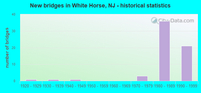
- New bridges - historical statistics
- 11920-1929
- 11930-1939
- 11940-1949
- 31970-1979
- 361980-1989
- 211990-1999


- Bridge Condition - Deck
- 2.9%Very good
- 77.1%Good
- 14.3%Satisfactory
- 5.7%Poor

- Bridge Condition - Superstructure
- 20.0%Very good
- 68.6%Good
- 5.7%Satisfactory
- 5.7%Fair

- Bridge Condition - Substructure
- 2.9%Very good
- 82.9%Good
- 11.4%Satisfactory
- 2.9%Fair

- Bridge Condition - Channel
- 23.1%Excellent
- 38.5%Very good
- 15.4%Good
- 15.4%Satisfactory
- 7.7%Fair
Find on map >> Show street view
Structure Number: 326152, Location: 0.26 MILES S OF I-195 JCT (Lat: 40.181889, Lng: -74.704461), Route carried "on" structure: US 206, Year Built: 1941, Year Reconstructed: 1994, Status: Open, Structure Length: 4.51m (14.80ft), Average Daily Traffic: 11,828 (year 2019), Truck Traffic: 4%, Average Future Daily Traffic: 14,433 (year 2039), Design Load: H 20, Features Intersected: CROSSWICKS CREEK
Minimum Vertical Clearance: 30+ m (98+ ft), Kilometerpoint: 61.879, Lanes on structure: 2, Base Highway Network: Yes, Owner: State Highway Agency, Approaching Roadway Width: 10.7m (35.1ft), Material/Design: Steel, Design/Construction: Stringer/Multi-beam, Number Of Spans In Main Unit: 2, Length of Maximum Span: 22.3m (73.2ft), Curb or Sidewalk Widths: Left: 0.0m, Right: 1.8m (5.9ft), Curb-To-Curb Width: 10.7m (35.1ft), Out-to-Out Width: 14.0m (45.9ft)
Condition: Deck: Poor, Superstructure: Fair, Substructure: Fair, Channel: Satisfactory, Operating Rating: 64.4 metric tons, Method Used To Determine Operating Rating: Load Factor (LF), Inventory Rating: 39.0 metric tons, Method Used To Determine Inventory Rating: Load Factor (LF), Structural Evaluation: Somewhat better than minimum adequacy, Deck Geometry: Somewhat better than minimum adequacy, Waterway Adequacy: Superior to present desirable criteria, Approach Roadway Alignment: Better than present minimum criteria, Length Of Structure Improvement: 5.43m (17.81ft), Designated Inspection Frequency: Every 24 months, Underwater Inspection Frequency: Every 24 months, Inspection Date: June 2021, Underwater Inspection Date: April 2021, Bridge Improvement Cost: $3,000, Total Project Cost: $5,000 ( Estimate for 2021), Deck Structure Type: Concrete Cast-file-Place
Find on map >> Show street view
Structure Number: 326153, Location: .4 MILE SOUTH OF 533 JCT (Lat: 40.182069, Lng: -74.704769), Route carried "on" structure: US 206, Year Built: 1924, Status: Open, Structure Length: 4.57m (14.99ft), Average Daily Traffic: 10,397 (year 2021), Truck Traffic: 4%, Average Future Daily Traffic: 12,686 (year 2041), Design Load: HS 20, Features Intersected: CROSSWICKS CREEK
Minimum Vertical Clearance: 30+ m (98+ ft), Kilometerpoint: 61.895, Lanes on structure: 2, Base Highway Network: Yes, Owner: State Highway Agency, Approaching Roadway Width: 9.1m (29.9ft), Navigation Control: Yes ( Vertical Clearance: 4.0m (13.1ft), Horizontal Clearance: 21.3m (69.9ft)), Material/Design: Steel, Design/Construction: Girder and Floorbeam System, Number Of Spans In Main Unit: 2, Length of Maximum Span: 22.6m (74.1ft), Curb or Sidewalk Widths: Left: 0.0m, Right: 2.7m (8.9ft), Curb-To-Curb Width: 9.2m (30.2ft), Out-to-Out Width: 9.4m (30.8ft)
Condition: Deck: Poor, Superstructure: Fair, Substructure: Satisfactory, Channel: Good, Operating Rating: 48.1 metric tons, Method Used To Determine Operating Rating: Load Factor (LF), Inventory Rating: 29.0 metric tons, Method Used To Determine Inventory Rating: Load Factor (LF), Structural Evaluation: Somewhat better than minimum adequacy, Deck Geometry: Meets minimum limits, Waterway Adequacy: Equal to present minimum criteria, Approach Roadway Alignment: Equal to present desirable criteria, Length Of Structure Improvement: 4.57m (14.99ft), Designated Inspection Frequency: Every 24 months, Critical Feature Inspection Frequency: Every 24 months, Inspection Date: March 2021, Critical Feature Inspection Date: March 2021, Bridge Improvement Cost: $2,012,000, Total Project Cost: $2,012,000 ( Estimate for 2019), Deck Structure Type: Concrete Cast-file-Place, Wearing Surface/Protective System: Wearing Surface: Bituminous
Find on map >> Show street view
Structure Number: 1106427, Location: 0.7 mile South of I-295 (Lat: 40.215469, Lng: -74.690281), Route carried "on" structure: County highway 533, Year Built: 1974, Status: Open, Structure Length: 0.85m (2.79ft), Average Daily Traffic: 14,340 (year 2021), Truck Traffic: 4%, Average Future Daily Traffic: 17,495 (year 2041), Design Load: HS 20, Features Intersected: POND RUN
Minimum Vertical Clearance: 30+ m (98+ ft), Kilometerpoint: 3.267, Lanes on structure: 4, Owner: County Highway Agency, Approaching Roadway Width: 16.5m (54.1ft), Skew: 1 degrees, Material/Design: Concrete, Design/Construction: Culvert, Number Of Spans In Main Unit: 1, Length of Maximum Span: 8.5m (27.9ft), Curb or Sidewalk Widths: Left: 0.0m, Right: 1.2m (3.9ft), Curb-To-Curb Width: 16.5m (54.1ft), Out-to-Out Width: 30.5m (100.1ft)
Condition: Channel: Fair, Culverts: Good, Operating Rating: 30.8 metric tons, Method Used To Determine Operating Rating: Load Factor (LF), Inventory Rating: 27.2 metric tons, Method Used To Determine Inventory Rating: Load Factor (LF), Structural Evaluation: Equal to present minimum criteria, Deck Geometry: Meets minimum limits, Waterway Adequacy: Better than present minimum criteria, Approach Roadway Alignment: Equal to present desirable criteria, Designated Inspection Frequency: Every 24 months, Inspection Date: March 2021
Find on map >> Show street view
Structure Number: 111615, Location: 0.28 MILES EAST OF I-195 (Lat: 40.187181, Lng: -74.688950), Route carried "on" structure: County highway 524, Year Built: 1931, Year Reconstructed: 1986, Status: Open, Structure Length: 1.37m (4.49ft), Average Daily Traffic: 18,858 (year 2021), Truck Traffic: 4%, Average Future Daily Traffic: 22,630 (year 2039), Design Load: HS 20, Features Intersected: GROPP LAKE
Minimum Vertical Clearance: 30+ m (98+ ft), Kilometerpoint: 1.432, Lanes on structure: 2, Base Highway Network: Yes, Owner: State Highway Agency, Approaching Roadway Width: 14.0m (45.9ft), Material/Design: Steel, Design/Construction: Stringer/Multi-beam, Number Of Spans In Main Unit: 1, Length of Maximum Span: 12.5m (41.0ft), Curb or Sidewalk Widths: Left: 1.8m (5.9ft), Right: 1.8m (5.9ft), Curb-To-Curb Width: 14.0m (45.9ft), Out-to-Out Width: 18.3m (60.0ft)
Condition: Deck: Good, Superstructure: Good, Substructure: Satisfactory, Channel: Satisfactory, Operating Rating: 53.5 metric tons, Method Used To Determine Operating Rating: Load Factor (LF), Inventory Rating: 31.8 metric tons, Method Used To Determine Inventory Rating: Load Factor (LF), Structural Evaluation: Equal to present minimum criteria, Deck Geometry: Superior to present desirable criteria, Waterway Adequacy: Better than present minimum criteria, Approach Roadway Alignment: Equal to present desirable criteria, Designated Inspection Frequency: Every 24 months, Underwater Inspection Frequency: Every 24 months, Inspection Date: April 2021, Underwater Inspection Date: April 2021, Deck Structure Type: Concrete Cast-file-Place, Wearing Surface/Protective System: Wearing Surface: Monolithic Concrete, Deck Protection: Epoxy Coated Reinforcing
Find on map >> Show street view
Structure Number: 113015, Location: 0.1 MI WEST OF RT.I-295 (Lat: 40.183839, Lng: -74.722839), Route carried "on" structure: State highway 29, Year Built: 1995, Status: Open, Structure Length: 29.35m (96.29ft), Average Daily Traffic: 29,295 (year 2020), Truck Traffic: 5%, Average Future Daily Traffic: 35,154 (year 2040), Design Load: HS 25 or greater, Features Intersected: WETLANDS
Minimum Vertical Clearance: 30+ m (98+ ft), Kilometerpoint: 0.225, Lanes on structure: 4, Base Highway Network: Yes, Owner: State Highway Agency, Approaching Roadway Width: 16.2m (53.1ft), Material/Design: Prestressed concrete, Design/Construction: Stringer/Multi-beam, Number Of Spans In Main Unit: 16, Length of Maximum Span: 18.3m (60.0ft), Curb-To-Curb Width: 16.2m (53.1ft), Out-to-Out Width: 17.2m (56.4ft)
Condition: Deck: Good, Superstructure: Very good, Substructure: Very good, Channel: Excellent, Operating Rating: 43.5 metric tons, Method Used To Determine Operating Rating: Load Factor (LF), Inventory Rating: 27.2 metric tons, Method Used To Determine Inventory Rating: Load Factor (LF), Structural Evaluation: Equal to present minimum criteria, Deck Geometry: Meets minimum limits, Waterway Adequacy: Superior to present desirable criteria, Approach Roadway Alignment: Equal to present desirable criteria, Designated Inspection Frequency: Every 24 months, Inspection Date: April 2020, Deck Structure Type: Concrete Cast-file-Place, Wearing Surface/Protective System: Wearing Surface: Latex Concrete, Deck Protection: Epoxy Coated Reinforcing
Find on map >> Show street view
Structure Number: 1130151, Location: 0.1 MI WEST OF I-295 (Lat: 40.184011, Lng: -74.726581), Route carried "on" structure: State highway 29, Year Built: 1995, Status: Open, Structure Length: 29.32m (96.19ft), Average Daily Traffic: 46,155 (year 2020), Truck Traffic: 5%, Average Future Daily Traffic: 55,386 (year 2040), Design Load: HS 20+Mod, Features Intersected: WETLANDS
Minimum Vertical Clearance: 30+ m (98+ ft), Kilometerpoint: 0.161, Lanes on structure: 4, Base Highway Network: Yes, Owner: State Highway Agency, Approaching Roadway Width: 22.9m (75.1ft), Skew: 20 degrees, Material/Design: Prestressed concrete, Design/Construction: Stringer/Multi-beam, Number Of Spans In Main Unit: 16, Length of Maximum Span: 18.3m (60.0ft), Curb-To-Curb Width: 22.9m (75.1ft), Out-to-Out Width: 25.8m (84.6ft)
Condition: Deck: Good, Superstructure: Very good, Substructure: Good, Channel: Excellent, Operating Rating: 68.9 metric tons, Method Used To Determine Operating Rating: Load Factor (LF), Inventory Rating: 40.8 metric tons, Method Used To Determine Inventory Rating: Load Factor (LF), Structural Evaluation: Better than present minimum criteria, Deck Geometry: Superior to present desirable criteria, Waterway Adequacy: Superior to present desirable criteria, Approach Roadway Alignment: Equal to present desirable criteria, Designated Inspection Frequency: Every 24 months, Inspection Date: March 2020, Deck Structure Type: Concrete Cast-file-Place, Wearing Surface/Protective System: Wearing Surface: Latex Concrete, Deck Protection: Epoxy Coated Reinforcing
Find on map >> Show street view
Structure Number: 1130152, Location: 0.41MI WEST OF 206 INT. (Lat: 40.184219, Lng: -74.727531), Route carried "on" structure: State highway 29, Year Built: 1995, Status: Open, Structure Length: 30.24m (99.21ft), Average Daily Traffic: 37,115 (year 2020), Truck Traffic: 5%, Average Future Daily Traffic: 54,930 (year 2020), Design Load: HS 25 or greater, Features Intersected: WATSON'S CREEK
Minimum Vertical Clearance: 30+ m (98+ ft), Kilometerpoint: 0.628, Lanes on structure: 5, Base Highway Network: Yes, Owner: State Highway Agency, Approaching Roadway Width: 16.2m (53.1ft), Material/Design: Prestressed concrete continuous, Design/Construction: Stringer/Multi-beam, Number Of Spans In Main Unit: 12, Length of Maximum Span: 27.4m (89.9ft), Curb-To-Curb Width: 23.5m (77.1ft), Out-to-Out Width: 24.5m (80.4ft)
Condition: Deck: Good, Superstructure: Good, Substructure: Good, Channel: Very good, Inventory Rating: 33.6 metric tons, Method Used To Determine Inventory Rating: Load Factor (LF), Structural Evaluation: Better than present minimum criteria, Deck Geometry: Equal to present minimum criteria, Waterway Adequacy: Equal to present desirable criteria, Approach Roadway Alignment: Equal to present desirable criteria, Designated Inspection Frequency: Every 24 months, Underwater Inspection Frequency: Every 48 months, Inspection Date: April 2020, Underwater Inspection Date: May 2018, Deck Structure Type: Concrete Cast-file-Place, Wearing Surface/Protective System: Wearing Surface: Latex Concrete, Deck Protection: Epoxy Coated Reinforcing
Find on map >> Show street view
Structure Number: 1130153, Location: 0.39 MI N OF I-295 JCT (Lat: 40.184189, Lng: -74.731081), Route carried "on" structure: State highway 29, Year Built: 1995, Status: Open, Structure Length: 30.24m (99.21ft), Average Daily Traffic: 36,953 (year 2020), Truck Traffic: 5%, Average Future Daily Traffic: 47,872 (year 2040), Design Load: HS 25 or greater, Features Intersected: WATSON'S CREEK
Minimum Vertical Clearance: 30+ m (98+ ft), Kilometerpoint: 0.579, Lanes on structure: 6, Base Highway Network: Yes, Owner: State Highway Agency, Approaching Roadway Width: 32.9m (107.9ft), Material/Design: Prestressed concrete continuous, Design/Construction: Stringer/Multi-beam, Number Of Spans In Main Unit: 11, Length of Maximum Span: 27.1m (88.9ft), Curb-To-Curb Width: 31.1m (102.0ft), Out-to-Out Width: 34.0m (111.5ft)
Condition: Deck: Good, Superstructure: Good, Substructure: Good, Channel: Very good, Operating Rating: 88.9 metric tons, Method Used To Determine Operating Rating: Load Factor (LF), Inventory Rating: 44.5 metric tons, Method Used To Determine Inventory Rating: Load Factor (LF), Structural Evaluation: Better than present minimum criteria, Deck Geometry: Superior to present desirable criteria, Waterway Adequacy: Equal to present desirable criteria, Approach Roadway Alignment: Equal to present desirable criteria, Designated Inspection Frequency: Every 24 months, Underwater Inspection Frequency: Every 48 months, Inspection Date: April 2020, Underwater Inspection Date: May 2018, Deck Structure Type: Concrete Cast-file-Place, Wearing Surface/Protective System: Wearing Surface: Latex Concrete, Deck Protection: Epoxy Coated Reinforcing
Find on map >> Show street view
Structure Number: 113415, Location: 0.51 MI E OF I-295 JCT. (Lat: 40.184289, Lng: -74.712289), Route carried "on" structure: City street , Year Built: 1985, Status: Open, Structure Length: 6.74m (22.11ft), Average Daily Traffic: 283 (year 2020), Truck Traffic: 1%, Average Future Daily Traffic: 340 (year 2040), Design Load: HS 20, Features Intersected: I-195, Facility Carried by Structure: HOBSON AVENUE
Minimum Vertical Clearance: 30+ m (98+ ft), Kilometerpoint: 0.000, Lanes on structure: 2, Lanes under structure: 7, Owner: State Highway Agency, Approaching Roadway Width: 9.4m (30.8ft), Material/Design: Steel continuous, Design/Construction: Stringer/Multi-beam, Number Of Spans In Main Unit: 2, Length of Maximum Span: 32.9m (107.9ft), Curb or Sidewalk Widths: Left: 1.8m (5.9ft), Right: 0.0m, Curb-To-Curb Width: 9.4m (30.8ft), Out-to-Out Width: 12.1m (39.7ft)
Condition: Deck: Good, Superstructure: Good, Substructure: Good, Inventory Rating: 59.9 metric tons, Method Used To Determine Inventory Rating: Load Factor (LF), Structural Evaluation: Better than present minimum criteria, Deck Geometry: Equal to present minimum criteria, Underclear: Equal to present minimum criteria, Approach Roadway Alignment: Equal to present minimum criteria, Designated Inspection Frequency: Every 24 months, Inspection Date: August 2020, Deck Structure Type: Concrete Cast-file-Place, Wearing Surface/Protective System: Wearing Surface: Latex Concrete, Deck Protection: Epoxy Coated Reinforcing
Find on map >> Show street view
Structure Number: 1134151, Location: RT I-195 & US 206 INTER. (Lat: 40.185689, Lng: -74.704689), Route carried "on" structure: US 206, Year Built: 1985, Status: Open, Structure Length: 7.25m (23.79ft), Average Daily Traffic: 24,370 (year 2021), Truck Traffic: 4%, Average Future Daily Traffic: 39,345 (year 2041), Design Load: HS 20+Mod, Features Intersected: I-195
Minimum Vertical Clearance: 30+ m (98+ ft), Kilometerpoint: 62.282, Lanes on structure: 5, Lanes under structure: 8, Base Highway Network: Yes, Owner: State Highway Agency, Approaching Roadway Width: 30.8m (101.0ft), Skew: 21 degrees, Material/Design: Steel continuous, Design/Construction: Stringer/Multi-beam, Number Of Spans In Main Unit: 2, Length of Maximum Span: 36.6m (120.1ft), Curb or Sidewalk Widths: Left: 1.8m (5.9ft), Right: 1.8m (5.9ft), Curb-To-Curb Width: 25.9m (85.0ft), Out-to-Out Width: 35.1m (115.2ft)
Condition: Deck: Good, Superstructure: Satisfactory, Substructure: Satisfactory, Inventory Rating: 58.1 metric tons, Method Used To Determine Inventory Rating: Load Factor (LF), Structural Evaluation: Equal to present minimum criteria, Deck Geometry: Superior to present desirable criteria, Underclear: Equal to present minimum criteria, Approach Roadway Alignment: Equal to present desirable criteria, Designated Inspection Frequency: Every 24 months, Inspection Date: June 2021, Deck Structure Type: Concrete Cast-file-Place, Wearing Surface/Protective System: Wearing Surface: Monolithic Concrete, Deck Protection: Epoxy Coated Reinforcing
Find on map >> Show street view
Structure Number: 1134152, Location: AT I-195 EXIT 1 (Lat: 40.182169, Lng: -74.703331), Route carried "on" structure: Ramp Interstate 195, Year Built: 1986, Status: Open, Structure Length: 5.82m (19.09ft), Average Daily Traffic: 13,094 (year 2021), Truck Traffic: 9%, Average Future Daily Traffic: 19,500 (year 2041), Design Load: HS 20+Mod, Features Intersected: CROSSWICKS CREEK
Minimum Vertical Clearance: 30+ m (98+ ft), Kilometerpoint: 1.481, Lanes on structure: 1, Base Highway Network: Yes, Owner: State Highway Agency, Approaching Roadway Width: 7.3m (24.0ft), Material/Design: Prestressed concrete, Design/Construction: Stringer/Multi-beam, Number Of Spans In Main Unit: 2, Length of Maximum Span: 28.0m (91.9ft), Curb-To-Curb Width: 7.3m (24.0ft), Out-to-Out Width: 8.4m (27.6ft)
Condition: Deck: Good, Superstructure: Good, Substructure: Good, Channel: Very good, Inventory Rating: 58.1 metric tons, Method Used To Determine Inventory Rating: Load Factor (LF), Structural Evaluation: Better than present minimum criteria, Deck Geometry: Better than present minimum criteria, Waterway Adequacy: Equal to present minimum criteria, Approach Roadway Alignment: Equal to present minimum criteria, Designated Inspection Frequency: Every 24 months, Inspection Date: April 2021, Deck Structure Type: Concrete Cast-file-Place, Wearing Surface/Protective System: Wearing Surface: Monolithic Concrete, Deck Protection: Epoxy Coated Reinforcing
Find on map >> Show street view
Structure Number: 1134154, Location: ON I-195 WB/CR 524 EB (Lat: 40.186669, Lng: -74.693331), Route carried "on" structure: Interstate 195, Year Built: 1986, Status: Open, Structure Length: 4.48m (14.70ft), Average Daily Traffic: 36,869 (year 2022), Truck Traffic: 9%, Average Future Daily Traffic: 44,987 (year 2042), Design Load: HS 20, Features Intersected: S BROAD ST EB(CR 524)
Minimum Vertical Clearance: 30+ m (98+ ft), Kilometerpoint: 2.494, Lanes on structure: 2, Lanes under structure: 1, Base Highway Network: Yes, Owner: State Highway Agency, Approaching Roadway Width: 12.8m (42.0ft), Skew: 2 degrees, Material/Design: Steel, Design/Construction: Stringer/Multi-beam, Number Of Spans In Main Unit: 1, Length of Maximum Span: 43.3m (142.1ft), Curb-To-Curb Width: 13.0m (42.7ft), Out-to-Out Width: 14.0m (45.9ft)
Condition: Deck: Good, Superstructure: Satisfactory, Substructure: Good, Inventory Rating: 63.5 metric tons, Method Used To Determine Inventory Rating: Load Factor (LF), Structural Evaluation: Equal to present minimum criteria, Deck Geometry: Superior to present desirable criteria, Underclear: Equal to present minimum criteria, Approach Roadway Alignment: Equal to present desirable criteria, Designated Inspection Frequency: Every 24 months, Inspection Date: November 2021, Deck Structure Type: Concrete Cast-file-Place, Wearing Surface/Protective System: Wearing Surface: Bituminous, Deck Protection: Epoxy Coated Reinforcing
Find on map >> Show street view
Structure Number: 1134155, Location: 0.63 MI E OF RT 206 JCT (Lat: 40.186811, Lng: -74.693669), Route carried "on" structure: Ramp Interstate 195, Year Built: 1986, Status: Open, Structure Length: 3.72m (12.20ft), Average Daily Traffic: 3,814 (year 2021), Truck Traffic: 9%, Average Future Daily Traffic: 4,557 (year 2041), Design Load: HS 20+Mod, Features Intersected: SOUTH BROAD ST E.B.
Minimum Vertical Clearance: 30+ m (98+ ft), Kilometerpoint: 2.494, Lanes on structure: 1, Lanes under structure: 1, Owner: State Highway Agency, Approaching Roadway Width: 7.3m (24.0ft), Material/Design: Steel, Design/Construction: Stringer/Multi-beam, Number Of Spans In Main Unit: 1, Length of Maximum Span: 36.3m (119.1ft), Curb-To-Curb Width: 7.3m (24.0ft), Out-to-Out Width: 8.4m (27.6ft)
Condition: Deck: Good, Superstructure: Good, Substructure: Good, Inventory Rating: 68.9 metric tons, Method Used To Determine Inventory Rating: Load Factor (LF), Structural Evaluation: Better than present minimum criteria, Deck Geometry: Better than present minimum criteria, Underclear: Better than present minimum criteria, Approach Roadway Alignment: Equal to present minimum criteria, Designated Inspection Frequency: Every 24 months, Inspection Date: April 2021, Deck Structure Type: Concrete Cast-file-Place, Wearing Surface/Protective System: Wearing Surface: Latex Concrete
Find on map >> Show street view
Structure Number: 1134156, Location: 0.1 MI EAST OF CO.RT 524 (Lat: 40.189289, Lng: -74.688869), Route carried "on" structure: City street , Year Built: 1973, Status: Open, Structure Length: 7.47m (24.51ft), Average Daily Traffic: 3,455 (year 2019), Truck Traffic: 1%, Average Future Daily Traffic: 4,560 (year 2039), Design Load: HS 20, Features Intersected: I-195, Facility Carried by Structure: LAKESIDE BLVD
Minimum Vertical Clearance: 30+ m (98+ ft), Kilometerpoint: 0.000, Lanes on structure: 2, Lanes under structure: 5, Owner: State Highway Agency, Approaching Roadway Width: 9.1m (29.9ft), Skew: 3 degrees, Material/Design: Steel, Design/Construction: Stringer/Multi-beam, Number Of Spans In Main Unit: 2, Length of Maximum Span: 39.6m (129.9ft), Curb or Sidewalk Widths: Left: 1.8m (5.9ft), Right: 1.8m (5.9ft), Curb-To-Curb Width: 9.1m (29.9ft), Out-to-Out Width: 13.6m (44.6ft)
Condition: Deck: Satisfactory, Superstructure: Good, Substructure: Good, Operating Rating: 77.1 metric tons, Method Used To Determine Operating Rating: Load Factor (LF), Inventory Rating: 46.3 metric tons, Method Used To Determine Inventory Rating: Load Factor (LF), Structural Evaluation: Better than present minimum criteria, Deck Geometry: Meets minimum limits, Underclear: High priority of corrective action, Approach Roadway Alignment: Equal to present desirable criteria, Length Of Structure Improvement: 7.47m (24.51ft), Designated Inspection Frequency: Every 24 months, Inspection Date: August 2021, Bridge Improvement Cost: $680,000, Roadway Improvement Cost: $136,000, Total Project Cost: $1,030,000 ( Estimate for 2019), Deck Structure Type: Concrete Cast-file-Place, Wearing Surface/Protective System: Wearing Surface: Monolithic Concrete
Find on map >> Show street view
Structure Number: 1134171, Location: 0.7 MI EAST OF RT 206 (Lat: 40.187389, Lng: -74.691831), Route carried "on" structure: Interstate 195, Year Built: 1986, Status: Open, Structure Length: 9.91m (32.51ft), Average Daily Traffic: 27,693 (year 2019), Truck Traffic: 9%, Average Future Daily Traffic: 33,252 (year 2019), Design Load: HS 20+Mod, Features Intersected: S.BROAD ST & ARENA DRIVE
Minimum Vertical Clearance: 30+ m (98+ ft), Kilometerpoint: 2.688, Lanes on structure: 2, Lanes under structure: 4, Base Highway Network: Yes, Owner: State Highway Agency, Approaching Roadway Width: 13.0m (42.7ft), Skew: 4 degrees, Material/Design: Steel, Design/Construction: Stringer/Multi-beam, Number Of Spans In Main Unit: 3, Length of Maximum Span: 41.8m (137.1ft), Curb-To-Curb Width: 13.0m (42.7ft), Out-to-Out Width: 14.0m (45.9ft)
Condition: Deck: Good, Superstructure: Good, Substructure: Good, Inventory Rating: 73.5 metric tons, Method Used To Determine Inventory Rating: Load Factor (LF), Structural Evaluation: Better than present minimum criteria, Deck Geometry: Superior to present desirable criteria, Underclear: Equal to present minimum criteria, Approach Roadway Alignment: Equal to present desirable criteria, Designated Inspection Frequency: Every 24 months, Inspection Date: March 2021, Deck Structure Type: Concrete Cast-file-Place, Wearing Surface/Protective System: Wearing Surface: Bituminous, Deck Protection: Epoxy Coated Reinforcing
Find on map >> Show street view
Structure Number: 1134172, Location: 0.75 MI E OF US 206 JCT (Lat: 40.188139, Lng: -74.691239), Route carried "on" structure: Interstate 195, Year Built: 1986, Status: Open, Structure Length: 12.04m (39.50ft), Average Daily Traffic: 32,815 (year 2019), Truck Traffic: 9%, Average Future Daily Traffic: 40,040 (year 2039), Design Load: HS 20+Mod, Features Intersected: S Broad St WB & Arena Dr
Minimum Vertical Clearance: 30+ m (98+ ft), Kilometerpoint: 2.688, Lanes on structure: 2, Lanes under structure: 4, Base Highway Network: Yes, Owner: State Highway Agency, Approaching Roadway Width: 13.0m (42.7ft), Skew: 4 degrees, Material/Design: Steel, Design/Construction: Stringer/Multi-beam, Number Of Spans In Main Unit: 3, Length of Maximum Span: 41.8m (137.1ft), Curb-To-Curb Width: 13.0m (42.7ft), Out-to-Out Width: 14.0m (45.9ft)
Condition: Deck: Good, Superstructure: Good, Substructure: Good, Inventory Rating: 73.5 metric tons, Method Used To Determine Inventory Rating: Load Factor (LF), Structural Evaluation: Better than present minimum criteria, Deck Geometry: Superior to present desirable criteria, Underclear: Somewhat better than minimum adequacy, Approach Roadway Alignment: Equal to present desirable criteria, Designated Inspection Frequency: Every 24 months, Inspection Date: March 2021, Deck Structure Type: Concrete Cast-file-Place, Wearing Surface/Protective System: Wearing Surface: Bituminous, Deck Protection: Epoxy Coated Reinforcing
Find on map >> Show street view
Structure Number: 1134173, Location: 0.7 MILE EAST OF RT 206 (Lat: 40.188111, Lng: -74.691400), Route carried "on" structure: Ramp Interstate 195, Year Built: 1986, Status: Open, Structure Length: 6.86m (22.51ft), Average Daily Traffic: 4,413 (year 2021), Truck Traffic: 9%, Average Future Daily Traffic: 5,295 (year 2041), Design Load: HS 20, Features Intersected: ARENA DRIVE (CO. 620)
Minimum Vertical Clearance: 30+ m (98+ ft), Kilometerpoint: 2.736, Lanes on structure: 1, Lanes under structure: 2, Owner: State Highway Agency, Approaching Roadway Width: 7.3m (24.0ft), Material/Design: Steel, Design/Construction: Stringer/Multi-beam, Number Of Spans In Main Unit: 2, Length of Maximum Span: 34.4m (112.9ft), Curb-To-Curb Width: 7.3m (24.0ft), Out-to-Out Width: 8.4m (27.6ft)
Condition: Deck: Satisfactory, Superstructure: Very good, Substructure: Good, Inventory Rating: 59.9 metric tons, Method Used To Determine Inventory Rating: Load Factor (LF), Structural Evaluation: Better than present minimum criteria, Deck Geometry: Better than present minimum criteria, Underclear: Equal to present minimum criteria, Approach Roadway Alignment: Equal to present desirable criteria, Designated Inspection Frequency: Every 24 months, Inspection Date: August 2021, Deck Structure Type: Concrete Cast-file-Place, Wearing Surface/Protective System: Wearing Surface: Monolithic Concrete, Deck Protection: Epoxy Coated Reinforcing
Find on map >> Show street view
Structure Number: 1134174, Location: 0.74 Mi E of US 206 Jct. (Lat: 40.187331, Lng: -74.691331), Route carried "on" structure: Ramp Interstate 195, Year Built: 1986, Status: Open, Structure Length: 6.95m (22.80ft), Average Daily Traffic: 4,513 (year 2020), Truck Traffic: 9%, Average Future Daily Traffic: 6,325 (year 2040), Design Load: HS 20+Mod, Features Intersected: S Broad St WB&Arena DrNB
Minimum Vertical Clearance: 30.45m (99.90ft), Kilometerpoint: 2.688, Lanes on structure: 1, Lanes under structure: 3, Owner: State Highway Agency, Approaching Roadway Width: 7.3m (24.0ft), Material/Design: Steel, Design/Construction: Stringer/Multi-beam, Number Of Spans In Main Unit: 2, Length of Maximum Span: 37.8m (124.0ft), Curb-To-Curb Width: 7.3m (24.0ft), Out-to-Out Width: 8.4m (27.6ft)
Condition: Deck: Satisfactory, Superstructure: Good, Substructure: Good, Operating Rating: 89.8 metric tons, Method Used To Determine Operating Rating: Load Factor (LF), Inventory Rating: 73.5 metric tons, Method Used To Determine Inventory Rating: Load Factor (LF), Structural Evaluation: Better than present minimum criteria, Deck Geometry: Better than present minimum criteria, Underclear: Equal to present minimum criteria, Approach Roadway Alignment: Equal to present minimum criteria, Designated Inspection Frequency: Every 24 months, Inspection Date: September 2020, Deck Structure Type: Concrete Cast-file-Place, Wearing Surface/Protective System: Wearing Surface: Latex Concrete, Deck Protection: Epoxy Coated Reinforcing
Find on map >> Show street view
Structure Number: 1134176, Location: 0.14 MI EAST OF I-295 JCT (Lat: 40.183489, Lng: -74.719361), Route carried "on" structure: Interstate 195, Year Built: 1994, Status: Open, Structure Length: 2.96m (9.71ft), Average Daily Traffic: 45,458 (year 2021), Truck Traffic: 9%, Average Future Daily Traffic: 66,913 (year 2041), Design Load: HS 20+Mod, Features Intersected: I-195 RAMP "H"
Minimum Vertical Clearance: 30+ m (98+ ft), Kilometerpoint: 0.225, Lanes on structure: 4, Lanes under structure: 2, Base Highway Network: Yes, Owner: State Highway Agency, Approaching Roadway Width: 23.9m (78.4ft), Skew: 1 degrees, Material/Design: Prestressed concrete, Design/Construction: Stringer/Multi-beam, Number Of Spans In Main Unit: 1, Length of Maximum Span: 28.0m (91.9ft), Curb-To-Curb Width: 23.9m (78.4ft), Out-to-Out Width: 25.0m (82.0ft)
Condition: Deck: Very good, Superstructure: Good, Substructure: Good, Operating Rating: 69.9 metric tons, Method Used To Determine Operating Rating: Load Factor (LF), Inventory Rating: 41.7 metric tons, Method Used To Determine Inventory Rating: Load Factor (LF), Structural Evaluation: Better than present minimum criteria, Deck Geometry: Superior to present desirable criteria, Underclear: Superior to present desirable criteria, Approach Roadway Alignment: Equal to present desirable criteria, Designated Inspection Frequency: Every 24 months, Inspection Date: April 2021, Deck Structure Type: Concrete Cast-file-Place, Wearing Surface/Protective System: Wearing Surface: Latex Concrete, Deck Protection: Epoxy Coated Reinforcing
Find on map >> Show street view
Structure Number: 1134177, Location: 0.14 MI EAST OF I-295 (Lat: 40.183969, Lng: -74.718981), Route carried "on" structure: Interstate 195, Year Built: 1994, Status: Open, Structure Length: 2.96m (9.71ft), Average Daily Traffic: 38,081 (year 2020), Truck Traffic: 9%, Average Future Daily Traffic: 46,467 (year 2040), Design Load: HS 20+Mod, Features Intersected: I-295 RAMP H
Minimum Vertical Clearance: 30+ m (98+ ft), Kilometerpoint: 0.257, Lanes on structure: 3, Lanes under structure: 2, Base Highway Network: Yes, Owner: State Highway Agency, Approaching Roadway Width: 16.2m (53.1ft), Skew: 1 degrees, Material/Design: Prestressed concrete, Design/Construction: Stringer/Multi-beam, Number Of Spans In Main Unit: 1, Length of Maximum Span: 28.0m (91.9ft), Curb-To-Curb Width: 16.2m (53.1ft), Out-to-Out Width: 17.2m (56.4ft)
Condition: Deck: Good, Superstructure: Very good, Substructure: Good, Operating Rating: 71.7 metric tons, Method Used To Determine Operating Rating: Load Factor (LF), Inventory Rating: 42.6 metric tons, Method Used To Determine Inventory Rating: Load Factor (LF), Structural Evaluation: Better than present minimum criteria, Deck Geometry: Equal to present minimum criteria, Underclear: Superior to present desirable criteria, Approach Roadway Alignment: Equal to present desirable criteria, Designated Inspection Frequency: Every 24 months, Inspection Date: May 2020, Deck Structure Type: Concrete Cast-file-Place, Wearing Surface/Protective System: Wearing Surface: Bituminous, Membrane: Preformed Fabric, Deck Protection: Epoxy Coated Reinforcing
Find on map >> Show street view
Structure Number: 1136151, Location: 0.39 MI. WEST OF RT.206 (Lat: 40.183531, Lng: -74.726531), Route carried "on" structure: Ramp Interstate 195, Year Built: 1994, Status: Open, Structure Length: 54.92m (180.18ft), Average Daily Traffic: 11,719 (year 2020), Truck Traffic: 9%, Average Future Daily Traffic: 14,299 (year 2040), Design Load: HS 20, Features Intersected: WETLANDS
Minimum Vertical Clearance: 30+ m (98+ ft), Kilometerpoint: 0.000, Lanes on structure: 2, Owner: State Highway Agency, Approaching Roadway Width: 12.8m (42.0ft), Material/Design: Prestressed concrete, Design/Construction: Stringer/Multi-beam, Number Of Spans In Main Unit: 30, Length of Maximum Span: 18.3m (60.0ft), Curb-To-Curb Width: 12.5m (41.0ft), Out-to-Out Width: 13.6m (44.6ft)
Condition: Deck: Good, Superstructure: Good, Substructure: Satisfactory, Channel: Excellent, Operating Rating: 58.1 metric tons, Method Used To Determine Operating Rating: Load Factor (LF), Inventory Rating: 33.6 metric tons, Method Used To Determine Inventory Rating: Load Factor (LF), Structural Evaluation: Equal to present minimum criteria, Deck Geometry: Superior to present desirable criteria, Waterway Adequacy: Superior to present desirable criteria, Approach Roadway Alignment: Equal to present desirable criteria, Length Of Structure Improvement: 54.92m (180.18ft), Designated Inspection Frequency: Every 24 months, Inspection Date: April 2020, Bridge Improvement Cost: $1,050,000, Total Project Cost: $15,000,000 ( Estimate for 2018), Deck Structure Type: Concrete Cast-file-Place, Wearing Surface/Protective System: Wearing Surface: Latex Concrete, Deck Protection: Epoxy Coated Reinforcing
Find on map >> Show street view
Structure Number: 1136152, Location: AT I-295&I-195/NJ29 JCT (Lat: 40.182050, Lng: -74.724039), Route carried "on" structure: Ramp Interstate 295, Year Built: 1994, Status: Open, Structure Length: 27.89m (91.50ft), Average Daily Traffic: 11,562 (year 2020), Truck Traffic: 9%, Average Future Daily Traffic: 14,108 (year 2040), Design Load: HS 25 or greater, Features Intersected: WATSON'S CRK & WETLANDS
Minimum Vertical Clearance: 30+ m (98+ ft), Kilometerpoint: 96.722, Lanes on structure: 1, Owner: State Highway Agency, Approaching Roadway Width: 6.7m (22.0ft), Skew: 9 degrees, Material/Design: Prestressed concrete, Design/Construction: Stringer/Multi-beam, Number Of Spans In Main Unit: 15, Length of Maximum Span: 21.6m (70.9ft), Curb-To-Curb Width: 6.7m (22.0ft), Out-to-Out Width: 7.8m (25.6ft)
Condition: Deck: Good, Superstructure: Good, Substructure: Good, Channel: Very good, Operating Rating: 76.2 metric tons, Method Used To Determine Operating Rating: Load Factor (LF), Inventory Rating: 45.4 metric tons, Method Used To Determine Inventory Rating: Load Factor (LF), Structural Evaluation: Better than present minimum criteria, Deck Geometry: Equal to present minimum criteria, Waterway Adequacy: Superior to present desirable criteria, Approach Roadway Alignment: Equal to present minimum criteria, Designated Inspection Frequency: Every 24 months, Inspection Date: April 2020, Deck Structure Type: Concrete Cast-file-Place, Wearing Surface/Protective System: Wearing Surface: Latex Concrete, Deck Protection: Epoxy Coated Reinforcing
Find on map >> Show street view
Structure Number: 1136153, Location: JCT I-295&I-195/NJ 29 (Lat: 40.183281, Lng: -74.721881), Route carried "on" structure: Interstate 295, Year Built: 1994, Status: Open, Structure Length: 7.10m (23.29ft), Average Daily Traffic: 33,442 (year 2020), Truck Traffic: 9%, Average Future Daily Traffic: 40,806 (year 2040), Design Load: HS 25 or greater, Features Intersected: I-195
Minimum Vertical Clearance: 30+ m (98+ ft), Kilometerpoint: 96.931, Lanes on structure: 4, Lanes under structure: 9, Base Highway Network: Yes, Owner: State Highway Agency, Approaching Roadway Width: 19.2m (63.0ft), Material/Design: Steel, Design/Construction: Stringer/Multi-beam, Number Of Spans In Main Unit: 2, Length of Maximum Span: 39.3m (128.9ft), Curb-To-Curb Width: 19.2m (63.0ft), Out-to-Out Width: 20.3m (66.6ft)
Condition: Deck: Good, Superstructure: Good, Substructure: Good, Operating Rating: 76.2 metric tons, Method Used To Determine Operating Rating: Load Factor (LF), Inventory Rating: 45.4 metric tons, Method Used To Determine Inventory Rating: Load Factor (LF), Structural Evaluation: Better than present minimum criteria, Deck Geometry: Somewhat better than minimum adequacy, Underclear: Equal to present minimum criteria, Approach Roadway Alignment: Equal to present desirable criteria, Designated Inspection Frequency: Every 24 months, Inspection Date: June 2020, Deck Structure Type: Concrete Cast-file-Place, Wearing Surface/Protective System: Wearing Surface: Latex Concrete, Deck Protection: Epoxy Coated Reinforcing
Find on map >> Show street view
Structure Number: 1136154, Location: AT I-295, EXIT 60 (Lat: 40.183331, Lng: -74.722500), Route carried "on" structure: Interstate 295, Year Built: 1995, Status: Open, Structure Length: 7.10m (23.29ft), Average Daily Traffic: 37,765 (year 2021), Truck Traffic: 9%, Average Future Daily Traffic: 45,318 (year 2041), Design Load: HS 20, Features Intersected: I-195
Minimum Vertical Clearance: 30+ m (98+ ft), Kilometerpoint: 96.931, Lanes on structure: 5, Lanes under structure: 9, Base Highway Network: Yes, Owner: State Highway Agency, Approaching Roadway Width: 26.8m (87.9ft), Skew: 20 degrees, Material/Design: Steel, Design/Construction: Stringer/Multi-beam, Number Of Spans In Main Unit: 2, Length of Maximum Span: 39.3m (128.9ft), Curb-To-Curb Width: 26.8m (87.9ft), Out-to-Out Width: 29.7m (97.4ft)
Condition: Deck: Good, Superstructure: Good, Substructure: Good, Operating Rating: 68.9 metric tons, Method Used To Determine Operating Rating: Load Factor (LF), Inventory Rating: 40.8 metric tons, Method Used To Determine Inventory Rating: Load Factor (LF), Structural Evaluation: Better than present minimum criteria, Deck Geometry: Superior to present desirable criteria, Underclear: Equal to present minimum criteria, Approach Roadway Alignment: Equal to present desirable criteria, Designated Inspection Frequency: Every 24 months, Inspection Date: May 2021, Deck Structure Type: Concrete Cast-file-Place, Wearing Surface/Protective System: Wearing Surface: Latex Concrete, Deck Protection: Epoxy Coated Reinforcing
Find on map >> Show street view
Structure Number: 1136155, Location: 0.1 MI WEST OF I-195 (Lat: 40.185689, Lng: -74.721939), Route carried "on" structure: Interstate 295, Year Built: 1994, Status: Open, Structure Length: 2.99m (9.81ft), Average Daily Traffic: 33,561 (year 2020), Truck Traffic: 9%, Average Future Daily Traffic: 46,986 (year 2040), Design Load: HS 25 or greater, Features Intersected: RAMP CONNECTING 29 NB
Minimum Vertical Clearance: 30+ m (98+ ft), Kilometerpoint: 97.333, Lanes on structure: 3, Lanes under structure: 2, Base Highway Network: Yes, Owner: State Highway Agency, Approaching Roadway Width: 16.2m (53.1ft), Material/Design: Prestressed concrete, Design/Construction: Stringer/Multi-beam, Number Of Spans In Main Unit: 1, Length of Maximum Span: 28.0m (91.9ft), Curb-To-Curb Width: 16.2m (53.1ft), Out-to-Out Width: 17.2m (56.4ft)
Condition: Deck: Good, Superstructure: Very good, Substructure: Good, Operating Rating: 72.6 metric tons, Method Used To Determine Operating Rating: Load Factor (LF), Inventory Rating: 43.5 metric tons, Method Used To Determine Inventory Rating: Load Factor (LF), Structural Evaluation: Better than present minimum criteria, Deck Geometry: Equal to present minimum criteria, Underclear: Superior to present desirable criteria, Approach Roadway Alignment: Equal to present desirable criteria, Designated Inspection Frequency: Every 24 months, Inspection Date: May 2020, Deck Structure Type: Concrete Cast-file-Place, Wearing Surface/Protective System: Wearing Surface: Latex Concrete, Deck Protection: Epoxy Coated Reinforcing
Find on map >> Show street view
Structure Number: 1136156, Location: AT I-295 EXIT 60 (Lat: 40.186050, Lng: -74.722311), Route carried "on" structure: Interstate 295, Year Built: 1994, Status: Open, Structure Length: 2.93m (9.61ft), Average Daily Traffic: 32,862 (year 2021), Truck Traffic: 9%, Average Future Daily Traffic: 40,097 (year 2041), Design Load: HS 20+Mod, Features Intersected: I-195 RAMP "H"
Minimum Vertical Clearance: 30+ m (98+ ft), Kilometerpoint: 97.172, Lanes on structure: 4, Lanes under structure: 2, Base Highway Network: Yes, Owner: State Highway Agency, Approaching Roadway Width: 24.2m (79.4ft), Skew: 30 degrees, Material/Design: Prestressed concrete, Design/Construction: Stringer/Multi-beam, Number Of Spans In Main Unit: 1, Length of Maximum Span: 28.0m (91.9ft), Curb-To-Curb Width: 24.2m (79.4ft), Out-to-Out Width: 27.1m (88.9ft)
Condition: Deck: Good, Superstructure: Very good, Substructure: Good, Operating Rating: 74.4 metric tons, Method Used To Determine Operating Rating: Load Factor (LF), Inventory Rating: 46.3 metric tons, Method Used To Determine Inventory Rating: Load Factor (LF), Structural Evaluation: Better than present minimum criteria, Deck Geometry: Superior to present desirable criteria, Underclear: Superior to present desirable criteria, Approach Roadway Alignment: Equal to present desirable criteria, Designated Inspection Frequency: Every 24 months, Inspection Date: April 2021, Deck Structure Type: Concrete Cast-file-Place, Wearing Surface/Protective System: Wearing Surface: Latex Concrete, Deck Protection: Epoxy Coated Reinforcing
Find on map >> Show street view
Structure Number: 1136176, Location: 0.54 MI S I195 & I295 JCT (Lat: 40.177239, Lng: -74.722050), Route carried "on" structure: Interstate 295, Year Built: 1994, Status: Open, Structure Length: 29.66m (97.31ft), Average Daily Traffic: 47,895 (year 2020), Truck Traffic: 9%, Average Future Daily Traffic: 58,441 (year 2040), Design Load: HS 25 or greater, Features Intersected: WATSONS CRK,NJ TRNST,D&R
Minimum Vertical Clearance: 30+ m (98+ ft), Kilometerpoint: 96.062, Lanes on structure: 5, Base Highway Network: Yes, Owner: State Highway Agency, Approaching Roadway Width: 16.2m (53.1ft), Skew: 2 degrees, Material/Design: Steel continuous, Design/Construction: Stringer/Multi-beam, Number Of Spans In Main Unit: 7, Number Of Approach Spans: 1, Length of Maximum Span: 54.9m (180.1ft), Curb-To-Curb Width: 23.5m (77.1ft), Out-to-Out Width: 24.5m (80.4ft)
Condition: Deck: Good, Superstructure: Good, Substructure: Good, Channel: Good, Operating Rating: 59.9 metric tons, Method Used To Determine Operating Rating: Load Factor (LF), Inventory Rating: 36.3 metric tons, Method Used To Determine Inventory Rating: Load Factor (LF), Structural Evaluation: Better than present minimum criteria, Deck Geometry: Equal to present minimum criteria, Underclear: Meets minimum limits, Waterway Adequacy: Equal to present desirable criteria, Approach Roadway Alignment: Equal to present desirable criteria, Designated Inspection Frequency: Every 24 months, Inspection Date: April 2020, Deck Structure Type: Concrete Cast-file-Place, Wearing Surface/Protective System: Wearing Surface: Latex Concrete, Deck Protection: Epoxy Coated Reinforcing
Find on map >> Show street view
Structure Number: 1136177, Location: 0.54M S I-195&I-295 JCT (Lat: 40.177639, Lng: -74.722489), Route carried "on" structure: Interstate 295, Year Built: 1994, Status: Open, Structure Length: 27.77m (91.11ft), Average Daily Traffic: 44,885 (year 2020), Truck Traffic: 9%, Average Future Daily Traffic: 54,768 (year 2040), Design Load: HS 25 or greater, Features Intersected: WATSONS CK,NJ TRNST,D&R
Minimum Vertical Clearance: 30+ m (98+ ft), Kilometerpoint: 96.094, Lanes on structure: 5, Base Highway Network: Yes, Owner: State Highway Agency, Approaching Roadway Width: 30.5m (100.1ft), Skew: 22 degrees, Material/Design: Steel continuous, Design/Construction: Stringer/Multi-beam, Number Of Spans In Main Unit: 7, Length of Maximum Span: 54.9m (180.1ft), Curb-To-Curb Width: 30.4m (99.7ft), Out-to-Out Width: 33.3m (109.3ft)
Condition: Deck: Good, Superstructure: Good, Substructure: Good, Channel: Very good, Operating Rating: 73.5 metric tons, Method Used To Determine Operating Rating: Load Factor (LF), Inventory Rating: 43.5 metric tons, Method Used To Determine Inventory Rating: Load Factor (LF), Structural Evaluation: Better than present minimum criteria, Deck Geometry: Superior to present desirable criteria, Underclear: Meets minimum limits, Waterway Adequacy: Equal to present desirable criteria, Approach Roadway Alignment: Equal to present desirable criteria, Designated Inspection Frequency: Every 24 months, Inspection Date: April 2020, Deck Structure Type: Concrete Cast-file-Place, Wearing Surface/Protective System: Wearing Surface: Latex Concrete, Deck Protection: Epoxy Coated Reinforcing
Find on map >> Show street view
Structure Number: 1137157, Location: 0.5 MI N JCT 195,129&29 (Lat: 40.189769, Lng: -74.719469), Route carried "on" structure: City street , Year Built: 1986, Status: Open, Structure Length: 6.68m (21.92ft), Average Daily Traffic: 1,682 (year 2020), Truck Traffic: 3%, Average Future Daily Traffic: 2,019 (year 2040), Design Load: HS 20+Mod, Features Intersected: ROUTE I-295, Facility Carried by Structure: INDEPENDENCE AVE.
Minimum Vertical Clearance: 30+ m (98+ ft), Kilometerpoint: 0.692, Lanes on structure: 2, Lanes under structure: 7, Owner: State Highway Agency, Approaching Roadway Width: 13.4m (44.0ft), Material/Design: Steel, Design/Construction: Stringer/Multi-beam, Number Of Spans In Main Unit: 2, Length of Maximum Span: 32.6m (107.0ft), Curb or Sidewalk Widths: Left: 1.8m (5.9ft), Right: 2.4m (7.9ft), Curb-To-Curb Width: 13.4m (44.0ft), Out-to-Out Width: 18.3m (60.0ft)
Condition: Deck: Good, Superstructure: Good, Substructure: Good, Inventory Rating: 60.8 metric tons, Method Used To Determine Inventory Rating: Load Factor (LF), Structural Evaluation: Better than present minimum criteria, Deck Geometry: Equal to present desirable criteria, Underclear: Equal to present minimum criteria, Approach Roadway Alignment: Better than present minimum criteria, Designated Inspection Frequency: Every 24 months, Inspection Date: Febuary 2020, Deck Structure Type: Concrete Cast-file-Place, Wearing Surface/Protective System: Wearing Surface: Monolithic Concrete, Deck Protection: Epoxy Coated Reinforcing
Find on map >> Show street view
Structure Number: 1137158, Location: .8 MI N OF WHITEHORSE CIR (Lat: 40.193331, Lng: -74.721669), Route carried "on" structure: US 206, Year Built: 1986, Status: Open, Structure Length: 6.52m (21.39ft), Average Daily Traffic: 20,738 (year 2020), Truck Traffic: 4%, Average Future Daily Traffic: 24,885 (year 2040), Design Load: HS 20+Mod, Features Intersected: ROUTE I-295
Minimum Vertical Clearance: 30+ m (98+ ft), Kilometerpoint: 63.778, Lanes on structure: 4, Lanes under structure: 6, Base Highway Network: Yes, Owner: State Highway Agency, Approaching Roadway Width: 21.3m (69.9ft), Skew: 20 degrees, Material/Design: Steel continuous, Design/Construction: Stringer/Multi-beam, Number Of Spans In Main Unit: 2, Length of Maximum Span: 32.0m (105.0ft), Curb or Sidewalk Widths: Left: 3.0m (9.8ft), Right: 3.0m (9.8ft), Curb-To-Curb Width: 21.3m (69.9ft), Out-to-Out Width: 31.1m (102.0ft)
Condition: Deck: Good, Superstructure: Good, Substructure: Good, Operating Rating: 64.4 metric tons, Method Used To Determine Operating Rating: Load Factor (LF), Inventory Rating: 39.0 metric tons, Method Used To Determine Inventory Rating: Load Factor (LF), Structural Evaluation: Better than present minimum criteria, Deck Geometry: Superior to present desirable criteria, Underclear: Equal to present minimum criteria, Approach Roadway Alignment: Equal to present desirable criteria, Designated Inspection Frequency: Every 24 months, Inspection Date: August 2020, Deck Structure Type: Concrete Cast-file-Place, Wearing Surface/Protective System: Wearing Surface: Latex Concrete, Deck Protection: Epoxy Coated Reinforcing
Find on map >> Show street view
Structure Number: 1137159, Location: 0.1 MI. N. OF BROAD ST. (Lat: 40.194711, Lng: -74.716700), Route carried "on" structure: City street , Year Built: 1986, Status: Open, Structure Length: 6.61m (21.69ft), Average Daily Traffic: 7,170 (year 2020), Truck Traffic: 4%, Average Future Daily Traffic: 8,610 (year 2040), Design Load: HS 20+Mod, Features Intersected: ROUTE I-295, Facility Carried by Structure: SOUTH CLINTON AVE.
Minimum Vertical Clearance: 30+ m (98+ ft), Kilometerpoint: 1.175, Lanes on structure: 2, Lanes under structure: 6, Owner: State Highway Agency, Approaching Roadway Width: 12.2m (40.0ft), Material/Design: Steel, Design/Construction: Stringer/Multi-beam, Number Of Spans In Main Unit: 2, Length of Maximum Span: 32.0m (105.0ft), Curb or Sidewalk Widths: Left: 2.4m (7.9ft), Right: 1.8m (5.9ft), Curb-To-Curb Width: 12.2m (40.0ft), Out-to-Out Width: 17.1m (56.1ft)
Condition: Deck: Good, Superstructure: Good, Substructure: Good, Inventory Rating: 73.5 metric tons, Method Used To Determine Inventory Rating: Load Factor (LF), Structural Evaluation: Better than present minimum criteria, Deck Geometry: Somewhat better than minimum adequacy, Underclear: Equal to present minimum criteria, Approach Roadway Alignment: Equal to present desirable criteria, Designated Inspection Frequency: Every 24 months, Inspection Date: May 2020, Deck Structure Type: Concrete Cast-file-Place, Wearing Surface/Protective System: Wearing Surface: Monolithic Concrete, Deck Protection: Epoxy Coated Reinforcing
Find on map >> Show street view
Structure Number: 1137162, Location: 1.2MI N OF 195/295 INTCHG (Lat: 40.199439, Lng: -74.711669), Route carried "on" structure: Interstate 295, Year Built: 1984, Status: Open, Structure Length: 4.24m (13.91ft), Average Daily Traffic: 36,098 (year 2021), Truck Traffic: 9%, Average Future Daily Traffic: 44,047 (year 2041), Design Load: HS 20+Mod, Features Intersected: ARENA DRIVE (CR 620)
Minimum Vertical Clearance: 30+ m (98+ ft), Kilometerpoint: 98.814, Lanes on structure: 4, Lanes under structure: 5, Base Highway Network: Yes, Owner: State Highway Agency, Approaching Roadway Width: 19.5m (64.0ft), Skew: 1 degrees, Material/Design: Steel, Design/Construction: Stringer/Multi-beam, Number Of Spans In Main Unit: 1, Length of Maximum Span: 40.8m (133.9ft), Curb-To-Curb Width: 19.7m (64.6ft), Out-to-Out Width: 20.8m (68.2ft)
Condition: Deck: Good, Superstructure: Good, Substructure: Good, Inventory Rating: 84.4 metric tons, Method Used To Determine Inventory Rating: Load Factor (LF), Structural Evaluation: Better than present minimum criteria, Deck Geometry: Equal to present minimum criteria, Underclear: Equal to present minimum criteria, Approach Roadway Alignment: Equal to present desirable criteria, Designated Inspection Frequency: Every 24 months, Inspection Date: March 2021, Deck Structure Type: Concrete Cast-file-Place, Wearing Surface/Protective System: Wearing Surface: Latex Concrete, Deck Protection: Epoxy Coated Reinforcing
Find on map >> Show street view
Structure Number: 1137163, Location: AT I-295 EXIT 61 (Lat: 40.199639, Lng: -74.712189), Route carried "on" structure: Interstate 295, Year Built: 1984, Status: Open, Structure Length: 4.24m (13.91ft), Average Daily Traffic: 34,470 (year 2021), Truck Traffic: 9%, Average Future Daily Traffic: 49,477 (year 2041), Design Load: HS 20+Mod, Features Intersected: ARENA DRIVE (CR 620)
Minimum Vertical Clearance: 30+ m (98+ ft), Kilometerpoint: 98.814, Lanes on structure: 4, Lanes under structure: 6, Base Highway Network: Yes, Owner: State Highway Agency, Approaching Roadway Width: 19.7m (64.6ft), Skew: 1 degrees, Material/Design: Steel, Design/Construction: Stringer/Multi-beam, Number Of Spans In Main Unit: 1, Length of Maximum Span: 40.8m (133.9ft), Curb-To-Curb Width: 19.7m (64.6ft), Out-to-Out Width: 20.8m (68.2ft)
Condition: Deck: Good, Superstructure: Good, Substructure: Good, Inventory Rating: 81.6 metric tons, Method Used To Determine Inventory Rating: Load Factor (LF), Structural Evaluation: Better than present minimum criteria, Deck Geometry: Equal to present minimum criteria, Underclear: Equal to present minimum criteria, Approach Roadway Alignment: Equal to present desirable criteria, Designated Inspection Frequency: Every 24 months, Inspection Date: March 2021, Deck Structure Type: Concrete Cast-file-Place, Wearing Surface/Protective System: Wearing Surface: Latex Concrete, Deck Protection: Other Coated Reinforcing
Find on map >> Show street view
Structure Number: 1137164, Location: 1.7MI N OF I195/I295 INT (Lat: 40.205361, Lng: -74.707931), Route carried "on" structure: Interstate 295, Year Built: 1984, Status: Open, Structure Length: 3.08m (10.10ft), Average Daily Traffic: 30,892 (year 2021), Truck Traffic: 9%, Average Future Daily Traffic: 41,926 (year 2041), Design Load: HS 20+Mod, Features Intersected: S.OLDEN AVE.(CO.RTE.622)
Minimum Vertical Clearance: 30+ m (98+ ft), Kilometerpoint: 99.602, Lanes on structure: 4, Lanes under structure: 2, Base Highway Network: Yes, Owner: State Highway Agency, Approaching Roadway Width: 20.4m (66.9ft), Skew: 10 degrees, Material/Design: Steel, Design/Construction: Stringer/Multi-beam, Number Of Spans In Main Unit: 1, Length of Maximum Span: 29.3m (96.1ft), Curb-To-Curb Width: 20.6m (67.6ft), Out-to-Out Width: 21.6m (70.9ft)
Condition: Deck: Satisfactory, Superstructure: Very good, Substructure: Good, Operating Rating: 67.1 metric tons, Method Used To Determine Operating Rating: Load Factor (LF), Inventory Rating: 39.9 metric tons, Method Used To Determine Inventory Rating: Load Factor (LF), Structural Evaluation: Better than present minimum criteria, Deck Geometry: Equal to present minimum criteria, Underclear: Meets minimum limits, Approach Roadway Alignment: Better than present minimum criteria, Designated Inspection Frequency: Every 24 months, Inspection Date: March 2021, Deck Structure Type: Concrete Cast-file-Place, Wearing Surface/Protective System: Wearing Surface: Monolithic Concrete, Deck Protection: Epoxy Coated Reinforcing
Find on map >> Show street view
Structure Number: 1137165, Location: 1.66 MI N OF I-195 JCT (Lat: 40.205381, Lng: -74.708311), Route carried "on" structure: Interstate 295, Year Built: 1984, Status: Open, Structure Length: 3.08m (10.10ft), Average Daily Traffic: 31,215 (year 2021), Truck Traffic: 9%, Average Future Daily Traffic: 41,824 (year 2041), Design Load: HS 20, Features Intersected: SOUTH OLDEN AVE.
Minimum Vertical Clearance: 30+ m (98+ ft), Kilometerpoint: 99.602, Lanes on structure: 3, Lanes under structure: 2, Base Highway Network: Yes, Owner: State Highway Agency, Approaching Roadway Width: 16.5m (54.1ft), Material/Design: Steel, Design/Construction: Stringer/Multi-beam, Number Of Spans In Main Unit: 1, Length of Maximum Span: 29.3m (96.1ft), Curb-To-Curb Width: 16.6m (54.5ft), Out-to-Out Width: 17.7m (58.1ft)
Condition: Deck: Satisfactory, Superstructure: Good, Substructure: Good, Operating Rating: 70.8 metric tons, Method Used To Determine Operating Rating: Load Factor (LF), Inventory Rating: 42.6 metric tons, Method Used To Determine Inventory Rating: Load Factor (LF), Structural Evaluation: Better than present minimum criteria, Deck Geometry: Equal to present minimum criteria, Underclear: Equal to present minimum criteria, Approach Roadway Alignment: Better than present minimum criteria, Designated Inspection Frequency: Every 24 months, Inspection Date: March 2021, Deck Structure Type: Concrete Cast-file-Place, Wearing Surface/Protective System: Wearing Surface: Latex Concrete, Deck Protection: Epoxy Coated Reinforcing
Find on map >> Show street view
Structure Number: 1137166, Location: 2.1MI N OF I95/295 INTERC (Lat: 40.211661, Lng: -74.704961), Route carried "on" structure: County highway 619, Year Built: 1984, Status: Open, Structure Length: 6.55m (21.49ft), Average Daily Traffic: 11,707 (year 2021), Truck Traffic: 4%, Average Future Daily Traffic: 14,284 (year 2041), Design Load: HS 20+Mod, Features Intersected: I-295
Minimum Vertical Clearance: 30+ m (98+ ft), Kilometerpoint: 1.014, Lanes on structure: 2, Lanes under structure: 6, Owner: State Highway Agency, Approaching Roadway Width: 12.2m (40.0ft), Skew: 1 degrees, Material/Design: Steel, Design/Construction: Stringer/Multi-beam, Number Of Spans In Main Unit: 2, Length of Maximum Span: 31.7m (104.0ft), Curb or Sidewalk Widths: Left: 1.8m (5.9ft), Right: 1.8m (5.9ft), Curb-To-Curb Width: 12.2m (40.0ft), Out-to-Out Width: 16.5m (54.1ft)
Condition: Deck: Good, Superstructure: Good, Substructure: Good, Inventory Rating: 72.6 metric tons, Method Used To Determine Inventory Rating: Load Factor (LF), Structural Evaluation: Better than present minimum criteria, Deck Geometry: Somewhat better than minimum adequacy, Underclear: Somewhat better than minimum adequacy, Approach Roadway Alignment: Equal to present minimum criteria, Designated Inspection Frequency: Every 24 months, Inspection Date: May 2021, Deck Structure Type: Concrete Cast-file-Place, Wearing Surface/Protective System: Wearing Surface: Monolithic Concrete, Deck Protection: Epoxy Coated Reinforcing
Find on map >> Show street view
Structure Number: 113415, Location: 0.51 MI E OF I-295 JCT. (Lat: 40.184289, Lng: -74.712289), Route carried "under" structure: Interstate 195, Year Built: 1985, Structure Length: 0. m, Average Daily Traffic: 91,100 (year 2020), Truck Traffic: 9%, Features Intersected: I-195, Facility Carried by Structure: HOBSON AVENUE
Minimum Vertical Clearance: 6.89m (22.60ft), Kilometerpoint: 0.821, Lanes on structure: 2, Lanes under structure: 7, Material/Design: Steel continuous, Design/Construction: Stringer/Multi-beam, Length of Maximum Span: 32.9m (107.9ft)
Find on map >> Show street view
Structure Number: 1134151, Location: RT I-195 & US 206 INTER. (Lat: 40.185689, Lng: -74.704689), Route carried "under" structure: Interstate 195, Year Built: 1985, Structure Length: 0. m, Average Daily Traffic: 82,470 (year 2021), Truck Traffic: 9%, Features Intersected: I-195, Facility Carried by Structure: US 206
Minimum Vertical Clearance: 6.20m (20.34ft), Kilometerpoint: 1.481, Lanes on structure: 5, Lanes under structure: 8, Material/Design: Steel continuous, Design/Construction: Stringer/Multi-beam, Length of Maximum Span: 36.6m (120.1ft)
Find on map >> Show street view
Structure Number: 1134154, Location: ON I-195 WB/CR 524 EB (Lat: 40.186669, Lng: -74.693331), Route carried "under" structure: County highway 524, Year Built: 1986, Structure Length: 0. m, Average Daily Traffic: 8,048 (year 2022), Truck Traffic: 4%, Features Intersected: S BROAD ST EB(CR 524), Facility Carried by Structure: I-195 WESTBOUND
Minimum Vertical Clearance: 6.04m (19.82ft), Kilometerpoint: 0.982, Lanes on structure: 2, Lanes under structure: 1, Material/Design: Steel, Design/Construction: Stringer/Multi-beam, Length of Maximum Span: 43.3m (142.1ft)
Find on map >> Show street view
Structure Number: 1134155, Location: 0.63 MI E OF RT 206 JCT (Lat: 40.186811, Lng: -74.693669), Route carried "under" structure: County highway 524, Year Built: 1986, Structure Length: 0. m, Average Daily Traffic: 7,991 (year 2021), Truck Traffic: 1%, Features Intersected: SOUTH BROAD ST E.B., Facility Carried by Structure: I-195 RAMP P
Minimum Vertical Clearance: 4.80m (15.75ft), Kilometerpoint: 0.950, Lanes on structure: 1, Lanes under structure: 1, Material/Design: Steel, Design/Construction: Stringer/Multi-beam, Length of Maximum Span: 36.3m (119.1ft)
Find on map >> Show street view
Structure Number: 1134156, Location: 0.1 MI EAST OF CO.RT 524 (Lat: 40.189289, Lng: -74.688869), Route carried "under" structure: Interstate 195, Year Built: 1973, Structure Length: 0. m, Average Daily Traffic: 72,925 (year 2019), Truck Traffic: 9%, Features Intersected: I-195, Facility Carried by Structure: LAKESIDE BLVD
Minimum Vertical Clearance: 5.21m (17.09ft), Kilometerpoint: 2.977, Lanes on structure: 2, Lanes under structure: 5, Material/Design: Steel, Design/Construction: Stringer/Multi-beam, Length of Maximum Span: 39.6m (129.9ft)
Find on map >> Show street view
Structure Number: 1134171, Location: 0.7 MI EAST OF RT 206 (Lat: 40.187389, Lng: -74.691831), Route carried "under" structure: County highway 524, Year Built: 1986, Structure Length: 0. m, Average Daily Traffic: 19,610 (year 2019), Truck Traffic: 4%, Features Intersected: S.BROAD ST & ARENA DRIVE, Facility Carried by Structure: I-195 EASTBOUND
Minimum Vertical Clearance: 5.49m (18.01ft), Kilometerpoint: 0.982, Lanes on structure: 2, Lanes under structure: 2, Material/Design: Steel, Design/Construction: Stringer/Multi-beam, Length of Maximum Span: 41.8m (137.1ft)
Find on map >> Show street view
Structure Number: 1134171, Location: 0.7 MI EAST OF RT 206 (Lat: 40.187389, Lng: -74.691831), Route carried "under" structure: County highway 620, Year Built: 1986, Structure Length: 0. m, Average Daily Traffic: 10,200 (year 2019), Truck Traffic: 4%, Features Intersected: S.BROAD ST & ARENA DRIVE, Facility Carried by Structure: I-195 EASTBOUND
Minimum Vertical Clearance: 5.85m (19.19ft), Kilometerpoint: 0.080, Lanes on structure: 2, Lanes under structure: 2, Material/Design: Steel, Design/Construction: Stringer/Multi-beam, Length of Maximum Span: 41.8m (137.1ft)
Find on map >> Show street view
Structure Number: 1134172, Location: 0.75 MI E OF US 206 JCT (Lat: 40.188139, Lng: -74.691239), Route carried "under" structure: County highway 524, Year Built: 1986, Structure Length: 0. m, Average Daily Traffic: 19,609 (year 2019), Truck Traffic: 4%, Features Intersected: S Broad St WB & Arena Dr, Facility Carried by Structure: I-195 Westbound
Minimum Vertical Clearance: 4.88m (16.01ft), Kilometerpoint: 0.982, Lanes on structure: 2, Lanes under structure: 2, Material/Design: Steel, Design/Construction: Stringer/Multi-beam, Length of Maximum Span: 41.8m (137.1ft)
Find on map >> Show street view
Structure Number: 1134172, Location: 0.75 MI E OF US 206 JCT (Lat: 40.188139, Lng: -74.691239), Route carried "under" structure: County highway 620, Year Built: 1986, Structure Length: 0. m, Average Daily Traffic: 9,982 (year 2017), Truck Traffic: 4%, Features Intersected: S Broad St WB & Arena Dr, Facility Carried by Structure: I-195 Westbound
Minimum Vertical Clearance: 4.97m (16.31ft), Kilometerpoint: 0.080, Lanes on structure: 2, Lanes under structure: 2, Material/Design: Steel, Design/Construction: Stringer/Multi-beam, Length of Maximum Span: 41.8m (137.1ft)
Find on map >> Show street view
Structure Number: 1134173, Location: 0.7 MILE EAST OF RT 206 (Lat: 40.188111, Lng: -74.691400), Route carried "under" structure: County highway 620, Year Built: 1986, Structure Length: 0. m, Average Daily Traffic: 11,977 (year 2021), Truck Traffic: 4%, Features Intersected: ARENA DRIVE (CO. 620), Facility Carried by Structure: RAMP LA OF I-195
Minimum Vertical Clearance: 4.78m (15.68ft), Kilometerpoint: 0.129, Lanes on structure: 1, Lanes under structure: 2, Material/Design: Steel, Design/Construction: Stringer/Multi-beam, Length of Maximum Span: 34.4m (112.9ft)
Find on map >> Show street view
Structure Number: 1134174, Location: 0.74 Mi E of US 206 Jct. (Lat: 40.187331, Lng: -74.691331), Route carried "under" structure: County highway 524, Year Built: 1986, Structure Length: 0. m, Average Daily Traffic: 10,155 (year 2020), Truck Traffic: 4%, Features Intersected: S Broad St WB&Arena DrNB, Facility Carried by Structure: I-195 Ramp "Q"
Minimum Vertical Clearance: 5.14m (16.86ft), Kilometerpoint: 1.175, Lanes on structure: 1, Lanes under structure: 2, Material/Design: Steel, Design/Construction: Stringer/Multi-beam, Length of Maximum Span: 37.8m (124.0ft)
Find on map >> Show street view
Structure Number: 1134174, Location: 0.74 Mi E of US 206 Jct. (Lat: 40.187331, Lng: -74.691331), Route carried "under" structure: County highway 620, Year Built: 1986, Structure Length: 0. m, Average Daily Traffic: 5,595 (year 2020), Truck Traffic: 4%, Features Intersected: S Broad St WB&Arena DrNB, Facility Carried by Structure: I-195 Ramp "Q"
Minimum Vertical Clearance: 6.13m (20.11ft), Kilometerpoint: 0.048, Lanes on structure: 1, Lanes under structure: 1, Material/Design: Steel, Design/Construction: Stringer/Multi-beam, Length of Maximum Span: 37.8m (124.0ft)
Find on map >> Show street view
Structure Number: 1134176, Location: 0.14 MI EAST OF I-295 JCT (Lat: 40.183489, Lng: -74.719361), Route carried "under" structure: Ramp Interstate 195, Year Built: 1994, Structure Length: 0. m, Average Daily Traffic: 5,503 (year 2021), Truck Traffic: 9%, Features Intersected: I-195 RAMP "H"
Minimum Vertical Clearance: 5.56m (18.24ft), Kilometerpoint: 0.225, Lanes on structure: 4, Lanes under structure: 2, Material/Design: Prestressed concrete, Design/Construction: Stringer/Multi-beam, Length of Maximum Span: 28.0m (91.9ft)