Bridge Statistics for Wheat Ridge, Colorado (CO)
Condition, Traffic, Stress, Structural Evaluation, Project Costs
- National Bridge Inventory (NBI) Statistics
- 48Number of bridges
- 719ft / 219mTotal length
- $12,711,000Total costs
- 2,215,402Total average daily traffic
- 171,324Total average daily truck traffic
- National Bridge Inventory (NBI) Registered Bridges for Wheat Ridge
- No street view available for this location
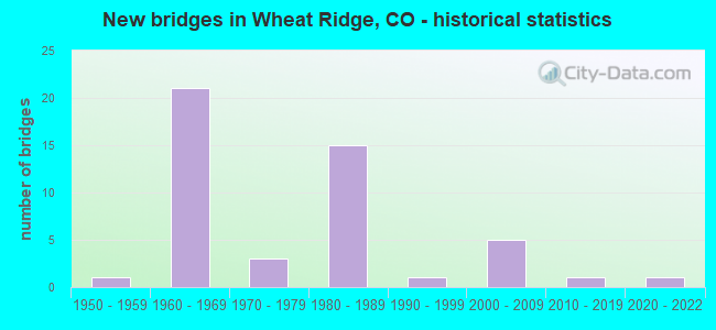
- New bridges - historical statistics
- 11950-1959
- 211960-1969
- 31970-1979
- 151980-1989
- 11990-1999
- 52000-2009
- 12010-2019
- 12020-2022
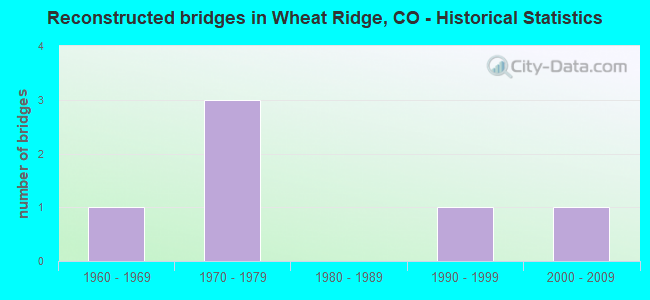
- Reconstructed bridges - Historical Statistics
- 11960-1969
- 31970-1979
- 01980-1989
- 11990-1999
- 12000-2009
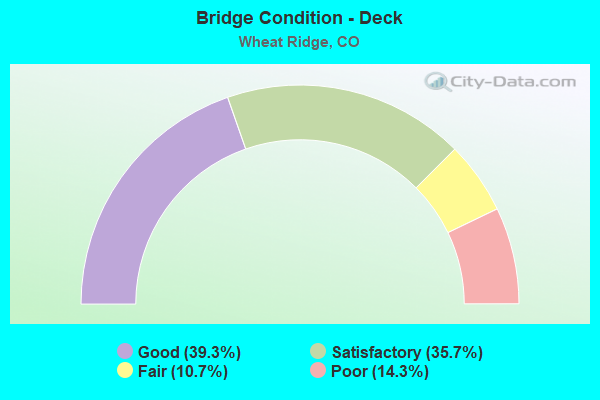
- Bridge Condition - Deck
- 39.3%Good
- 35.7%Satisfactory
- 10.7%Fair
- 14.3%Poor
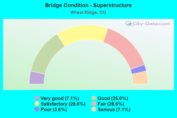
- Bridge Condition - Superstructure
- 7.1%Very good
- 25.0%Good
- 28.6%Satisfactory
- 28.6%Fair
- 3.6%Poor
- 7.1%Serious
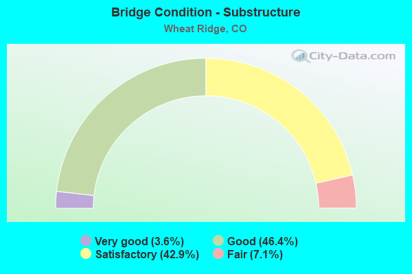
- Bridge Condition - Substructure
- 3.6%Very good
- 46.4%Good
- 42.9%Satisfactory
- 7.1%Fair

- Bridge Condition - Channel
- 50.0%Very good
- 22.2%Good
- 27.8%Satisfactory
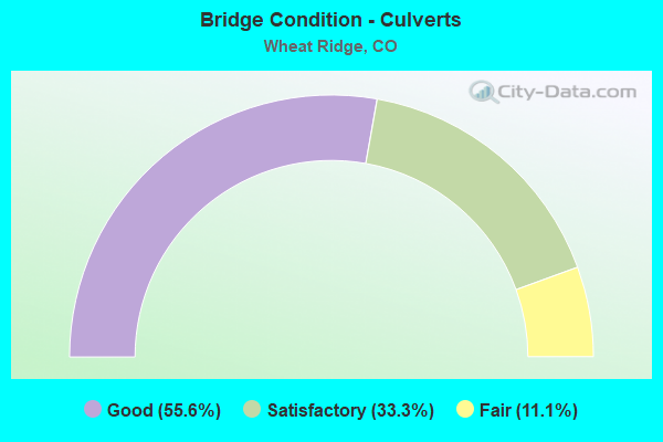
- Bridge Condition - Culverts
- 55.6%Good
- 33.3%Satisfactory
- 11.1%Fair
Find on map >> Show street view
Structure Number: E-16-C, Location: 3.9 MI NO OF JCT US 36 (Lat: 39.893292, Lng: -105.024881), Route carried "on" structure: US 287C, Year Built: 1951, Year Reconstructed: 1969, Status: Open, Structure Length: 0.88m (2.89ft), Average Daily Traffic: 27,000 (year 2020), Truck Traffic: 2%, Average Future Daily Traffic: 32,940 (year 2040), Design Load: HS 20+Mod, Features Intersected: FARMERS HIGHLINE CANAL, Facility Carried by Structure: US 287 ML
Minimum Vertical Clearance: 30+ m (98+ ft), Kilometerpoint: 16.995, Lanes on structure: 4, Base Highway Network: Yes, Owner: State Highway Agency, Approaching Roadway Width: 28.7m (94.2ft), Skew: 3 degrees, Material/Design: Concrete, Design/Construction: Slab, Number Of Spans In Main Unit: 1, Length of Maximum Span: 8.1m (26.6ft), Curb or Sidewalk Widths: Left: 0.0m, Right: 1.7m (5.6ft), Curb-To-Curb Width: 27.6m (90.6ft), Out-to-Out Width: 28.5m (93.5ft)
Condition: Deck: Satisfactory, Superstructure: Satisfactory, Substructure: Satisfactory, Channel: Very good, Operating Rating: 48.4 metric tons, Method Used To Determine Operating Rating: Load Factor (LF), Inventory Rating: 29.0 metric tons, Method Used To Determine Inventory Rating: Load Factor (LF), Structural Evaluation: Equal to present minimum criteria, Deck Geometry: Superior to present desirable criteria, Waterway Adequacy: Equal to present desirable criteria, Approach Roadway Alignment: Equal to present desirable criteria, Designated Inspection Frequency: Every 24 months, Inspection Date: March 2021, Deck Structure Type: Concrete Cast-file-Place, Wearing Surface/Protective System: Wearing Surface: Bituminous
Find on map >> Show street view
Structure Number: E-16-CW, Location: IN WHEATRIDGE (Lat: 39.782069, Lng: -105.130828), Route carried "on" structure: City street , Year Built: 1967, Status: Open, Structure Length: 6.90m (22.64ft), Average Daily Traffic: 3,587 (year 2021), Truck Traffic: 8%, Average Future Daily Traffic: 4,125 (year 2041), Design Load: HS 20+Mod, Features Intersected: I 70 ML, Facility Carried by Structure: TABOR STREET
Minimum Vertical Clearance: 30+ m (98+ ft), Kilometerpoint: 0.829, Lanes on structure: 2, Lanes under structure: 7, Owner: State Highway Agency, Approaching Roadway Width: 9.8m (32.2ft), Skew: 2 degrees, Material/Design: Steel continuous, Design/Construction: Stringer/Multi-beam, Number Of Spans In Main Unit: 2, Length of Maximum Span: 33.8m (110.9ft), Curb or Sidewalk Widths: Left: 0.9m (3.0ft), Right: 0.9m (3.0ft), Curb-To-Curb Width: 9.1m (29.9ft), Out-to-Out Width: 11.0m (36.1ft)
Condition: Deck: Satisfactory, Superstructure: Fair, Substructure: Satisfactory, Operating Rating: 55.5 metric tons, Method Used To Determine Operating Rating: Load Factor (LF), Inventory Rating: 33.3 metric tons, Method Used To Determine Inventory Rating: Load Factor (LF), Structural Evaluation: Somewhat better than minimum adequacy, Deck Geometry: Meets minimum limits, Underclear: Better than present minimum criteria, Approach Roadway Alignment: Equal to present desirable criteria, Length Of Structure Improvement: 6.89m (22.60ft), Designated Inspection Frequency: Every 24 months, Inspection Date: March 2020, Bridge Improvement Cost: $498,000, Roadway Improvement Cost: $50,000, Total Project Cost: $758,000, Deck Structure Type: Concrete Cast-file-Place, Wearing Surface/Protective System: Wearing Surface: Epoxy Overlay
Find on map >> Show street view
Structure Number: E-16-DE, Location: 6.3 MILES N. SH 58 (Lat: 39.849222, Lng: -105.233564), Route carried "on" structure: State highway 93A, Year Built: 1999, Status: Open, Structure Length: 0.78m (2.56ft), Average Daily Traffic: 17,000 (year 2020), Truck Traffic: 4%, Average Future Daily Traffic: 20,400 (year 2040), Design Load: HS 20, Features Intersected: LEYDEN GULCH, Facility Carried by Structure: SH 93 ML
Minimum Vertical Clearance: 30+ m (98+ ft), Kilometerpoint: 11.230, Lanes on structure: 3, Base Highway Network: Yes, Owner: State Highway Agency, Approaching Roadway Width: 18.8m (61.7ft), Skew: 4 degrees, Material/Design: Concrete, Design/Construction: Culvert, Number Of Spans In Main Unit: 2, Length of Maximum Span: 3.7m (12.1ft), Out-to-Out Width: 51.8m (169.9ft)
Condition: Channel: Good, Culverts: Satisfactory, Operating Rating: 89.8 metric tons, Method Used To Determine Operating Rating: Field evaluation and documented engineering judgment, Inventory Rating: 89.8 metric tons, Method Used To Determine Inventory Rating: Field evaluation and documented engineering judgment, Structural Evaluation: Equal to present minimum criteria, Waterway Adequacy: Equal to present desirable criteria, Approach Roadway Alignment: Equal to present desirable criteria, Designated Inspection Frequency: Every 24 months, Inspection Date: April 2020
Find on map >> Show street view
Structure Number: E-16-DI, Location: LAKESIDE (Lat: 39.783350, Lng: -105.053583), Route carried "on" structure: Interstate 70A, Year Built: 1966, Year Reconstructed: 1984, Status: Open, Structure Length: 6.22m (20.41ft), Average Daily Traffic: 93,000 (year 2020), Truck Traffic: 6%, Average Future Daily Traffic: 112,530 (year 2040), Design Load: HS 20, Features Intersected: SH 95 ML, Facility Carried by Structure: I 70 ML
Minimum Vertical Clearance: 30+ m (98+ ft), Kilometerpoint: 436.609, Lanes on structure: 7, Lanes under structure: 6, Base Highway Network: Yes, Owner: State Highway Agency, Approaching Roadway Width: 39.3m (128.9ft), Skew: 32 degrees, Material/Design: Concrete continuous, Design/Construction: Tee Beam, Number Of Spans In Main Unit: 4, Length of Maximum Span: 17.4m (57.1ft), Curb-To-Curb Width: 30.9m (101.4ft), Out-to-Out Width: 32.7m (107.3ft)
Condition: Deck: Fair, Superstructure: Satisfactory, Substructure: Satisfactory, Operating Rating: 54.7 metric tons, Method Used To Determine Operating Rating: Load Factor (LF), Inventory Rating: 32.7 metric tons, Method Used To Determine Inventory Rating: Load Factor (LF), Structural Evaluation: Equal to present minimum criteria, Deck Geometry: Equal to present minimum criteria, Underclear: Meets minimum limits, Approach Roadway Alignment: Equal to present desirable criteria, Designated Inspection Frequency: Every 24 months, Inspection Date: March 2020, Deck Structure Type: Concrete Cast-file-Place, Wearing Surface/Protective System: Wearing Surface: Bituminous
Find on map >> Show street view
Structure Number: E-16-DP, Location: KIPLING 0.65 MI S OF I70 (Lat: 39.774897, Lng: -105.109514), Route carried "on" structure: State highway 391A, Year Built: 1969, Status: Open, Structure Length: 4.77m (15.65ft), Average Daily Traffic: 37,000 (year 2020), Truck Traffic: 3%, Average Future Daily Traffic: 39,960 (year 2040), Design Load: HS 20+Mod, Features Intersected: CLEAR CREEK, Facility Carried by Structure: SH 391 ML
Minimum Vertical Clearance: 30+ m (98+ ft), Kilometerpoint: 13.987, Lanes on structure: 6, Base Highway Network: Yes, Owner: State Highway Agency, Approaching Roadway Width: 20.7m (67.9ft), Skew: 2 degrees, Material/Design: Prestressed concrete, Design/Construction: Stringer/Multi-beam, Number Of Spans In Main Unit: 2, Length of Maximum Span: 22.9m (75.1ft), Curb or Sidewalk Widths: Left: 1.1m (3.6ft), Right: 1.1m (3.6ft), Curb-To-Curb Width: 20.7m (67.9ft), Out-to-Out Width: 23.8m (78.1ft)
Condition: Deck: Poor, Superstructure: Good, Substructure: Fair, Channel: Satisfactory, Operating Rating: 55.3 metric tons, Method Used To Determine Operating Rating: Load Factor (LF), Inventory Rating: 32.7 metric tons, Method Used To Determine Inventory Rating: Load Factor (LF), Structural Evaluation: Somewhat better than minimum adequacy, Deck Geometry: High priority of replacement, Waterway Adequacy: Equal to present minimum criteria, Approach Roadway Alignment: Equal to present desirable criteria, Length Of Structure Improvement: 4.80m (15.75ft), Designated Inspection Frequency: Every 24 months, Inspection Date: January 2022, Bridge Improvement Cost: $1,090,000, Roadway Improvement Cost: $109,000, Total Project Cost: $1,200,000 ( Estimate for 2018), Deck Structure Type: Concrete Cast-file-Place, Wearing Surface/Protective System: Wearing Surface: Bituminous
Find on map >> Show street view
Structure Number: E-16-GC, Location: IN DENVER (Lat: 39.780544, Lng: -104.989069), Route carried "on" structure: Interstate 25A, Year Built: 1989, Status: Open, Structure Length: 10.95m (35.93ft), Average Daily Traffic: 200,000 (year 2020), Truck Traffic: 10%, Average Future Daily Traffic: 232,000 (year 2040), Design Load: HS 20+Mod, Features Intersected: RAMPS TO I 25/ I 70, Facility Carried by Structure: I 25 ML
Minimum Vertical Clearance: 30+ m (98+ ft), Kilometerpoint: 343.706, Lanes on structure: 10, Lanes under structure: 4, Base Highway Network: Yes, Owner: State Highway Agency, Approaching Roadway Width: 53.7m (176.2ft), Skew: 30 degrees, Material/Design: Steel continuous, Design/Construction: Box Beam or Girders - Multiple, Number Of Spans In Main Unit: 3, Length of Maximum Span: 36.0m (118.1ft), Curb-To-Curb Width: 52.4m (171.9ft), Out-to-Out Width: 54.6m (179.1ft)
Condition: Deck: Good, Superstructure: Good, Substructure: Good, Operating Rating: 60.1 metric tons, Method Used To Determine Operating Rating: Load Factor (LF), Inventory Rating: 35.9 metric tons, Method Used To Determine Inventory Rating: Load Factor (LF), Structural Evaluation: Better than present minimum criteria, Deck Geometry: Superior to present desirable criteria, Underclear: Equal to present minimum criteria, Approach Roadway Alignment: Equal to present desirable criteria, Designated Inspection Frequency: Every 24 months, Inspection Date: September 2021, Deck Structure Type: Concrete Cast-file-Place, Wearing Surface/Protective System: Wearing Surface: Bituminous, Membrane: Preformed Fabric
Find on map >> Show street view
Structure Number: E-16-GU, Location: IN ARVADA (Lat: 39.783539, Lng: -105.100536), Route carried "on" structure: Interstate 70A, Year Built: 1967, Year Reconstructed: 1979, Status: Open, Structure Length: 3.96m (12.99ft), Average Daily Traffic: 118,000 (year 2020), Truck Traffic: 10%, Average Future Daily Traffic: 140,420 (year 2040), Design Load: HS 20, Features Intersected: GARRISON STREET, Facility Carried by Structure: I 70 ML
Minimum Vertical Clearance: 30+ m (98+ ft), Kilometerpoint: 432.482, Lanes on structure: 9, Lanes under structure: 3, Base Highway Network: Yes, Owner: State Highway Agency, Approaching Roadway Width: 46.6m (152.9ft), Skew: 30 degrees, Material/Design: Concrete continuous, Design/Construction: Tee Beam, Number Of Spans In Main Unit: 3, Length of Maximum Span: 20.4m (66.9ft), Curb-To-Curb Width: 46.6m (152.9ft), Out-to-Out Width: 47.8m (156.8ft)
Condition: Deck: Fair, Superstructure: Satisfactory, Substructure: Good, Operating Rating: 58.3 metric tons, Method Used To Determine Operating Rating: Load Factor (LF), Inventory Rating: 34.9 metric tons, Method Used To Determine Inventory Rating: Load Factor (LF), Structural Evaluation: Equal to present minimum criteria, Deck Geometry: Superior to present desirable criteria, Underclear: Somewhat better than minimum adequacy, Approach Roadway Alignment: Equal to present desirable criteria, Designated Inspection Frequency: Every 24 months, Inspection Date: March 2020, Deck Structure Type: Concrete Cast-file-Place, Wearing Surface/Protective System: Wearing Surface: Bituminous, Membrane: Preformed Fabric
Find on map >> Show street view
Structure Number: E-16-GW, Location: IN ARVADA (Lat: 39.783536, Lng: -105.091081), Route carried "on" structure: Interstate 70A, Year Built: 1967, Year Reconstructed: 1979, Status: Open, Structure Length: 3.75m (12.30ft), Average Daily Traffic: 118,000 (year 2020), Truck Traffic: 10%, Average Future Daily Traffic: 140,420 (year 2040), Design Load: HS 20+Mod, Features Intersected: CARR STREET, Facility Carried by Structure: I 70 ML
Minimum Vertical Clearance: 30+ m (98+ ft), Kilometerpoint: 433.290, Lanes on structure: 12, Lanes under structure: 2, Base Highway Network: Yes, Owner: State Highway Agency, Approaching Roadway Width: 34.1m (111.9ft), Skew: 20 degrees, Material/Design: Concrete continuous, Design/Construction: Tee Beam, Number Of Spans In Main Unit: 3, Length of Maximum Span: 14.0m (45.9ft), Curb-To-Curb Width: 58.5m (191.9ft), Out-to-Out Width: 60.2m (197.5ft)
Condition: Deck: Good, Superstructure: Good, Substructure: Good, Operating Rating: 51.7 metric tons, Method Used To Determine Operating Rating: Load Factor (LF), Inventory Rating: 30.9 metric tons, Method Used To Determine Inventory Rating: Load Factor (LF), Structural Evaluation: Better than present minimum criteria, Deck Geometry: Superior to present desirable criteria, Underclear: Meets minimum limits, Approach Roadway Alignment: Equal to present desirable criteria, Designated Inspection Frequency: Every 24 months, Inspection Date: March 2020, Deck Structure Type: Concrete Cast-file-Place, Wearing Surface/Protective System: Wearing Surface: Monolithic Concrete, Deck Protection: Epoxy Coated Reinforcing
Find on map >> Show street view
Structure Number: E-16-GX, Location: WHEATRIDGE (Lat: 39.784292, Lng: -105.109925), Route carried "on" structure: Interstate 70A, Year Built: 1967, Status: Open, Structure Length: 5.27m (17.29ft), Average Daily Traffic: 57,000 (year 2020), Truck Traffic: 9%, Average Future Daily Traffic: 68,400 (year 2040), Design Load: HS 20+Mod, Features Intersected: SH 391 ML, Facility Carried by Structure: I 70 ML WBND
Minimum Vertical Clearance: 30+ m (98+ ft), Kilometerpoint: 431.676, Lanes on structure: 3, Lanes under structure: 7, Base Highway Network: Yes, Owner: State Highway Agency, Approaching Roadway Width: 15.2m (49.9ft), Skew: 10 degrees, Material/Design: Concrete continuous, Design/Construction: Tee Beam, Number Of Spans In Main Unit: 4, Length of Maximum Span: 16.3m (53.5ft), Curb-To-Curb Width: 12.8m (42.0ft), Out-to-Out Width: 14.0m (45.9ft)
Condition: Deck: Poor, Superstructure: Fair, Substructure: Good, Operating Rating: 48.5 metric tons, Method Used To Determine Operating Rating: Load Factor (LF), Inventory Rating: 29.1 metric tons, Method Used To Determine Inventory Rating: Load Factor (LF), Structural Evaluation: Somewhat better than minimum adequacy, Deck Geometry: High priority of replacement, Underclear: High priority of replacement, Approach Roadway Alignment: Equal to present desirable criteria, Length Of Structure Improvement: 5.27m (17.29ft), Designated Inspection Frequency: Every 24 months, Inspection Date: Febuary 2022, Bridge Improvement Cost: $1,262,000, Roadway Improvement Cost: $126,000, Total Project Cost: $1,893,000, Deck Structure Type: Concrete Cast-file-Place, Wearing Surface/Protective System: Wearing Surface: Bituminous, Membrane: Built-up
Find on map >> Show street view
Structure Number: E-16-GY, Location: WHEATRIDGE (Lat: 39.784083, Lng: -105.109931), Route carried "on" structure: Interstate 70A, Year Built: 1967, Status: Open, Structure Length: 5.27m (17.29ft), Average Daily Traffic: 57,000 (year 2020), Truck Traffic: 9%, Average Future Daily Traffic: 68,400 (year 2040), Design Load: HS 20+Mod, Features Intersected: SH 391 ML, Facility Carried by Structure: I 70 ML EBND
Minimum Vertical Clearance: 30+ m (98+ ft), Kilometerpoint: 431.674, Lanes on structure: 3, Lanes under structure: 7, Base Highway Network: Yes, Owner: State Highway Agency, Approaching Roadway Width: 15.2m (49.9ft), Skew: 10 degrees, Material/Design: Concrete continuous, Design/Construction: Tee Beam, Number Of Spans In Main Unit: 4, Length of Maximum Span: 16.3m (53.5ft), Curb-To-Curb Width: 12.8m (42.0ft), Out-to-Out Width: 14.0m (45.9ft)
Condition: Deck: Poor, Superstructure: Fair, Substructure: Good, Operating Rating: 49.1 metric tons, Method Used To Determine Operating Rating: Load Factor (LF), Inventory Rating: 29.4 metric tons, Method Used To Determine Inventory Rating: Load Factor (LF), Structural Evaluation: Somewhat better than minimum adequacy, Deck Geometry: High priority of replacement, Underclear: High priority of corrective action, Approach Roadway Alignment: Equal to present desirable criteria, Length Of Structure Improvement: 5.27m (17.29ft), Designated Inspection Frequency: Every 24 months, Inspection Date: Febuary 2020, Bridge Improvement Cost: $287,000, Roadway Improvement Cost: $29,000, Total Project Cost: $430,000, Deck Structure Type: Concrete Cast-file-Place, Wearing Surface/Protective System: Wearing Surface: Bituminous
Find on map >> Show street view
Structure Number: E-16-HF, Location: WHEATRIDGE (Lat: 39.761897, Lng: -105.143281), Route carried "on" structure: Interstate 70A, Year Built: 1968, Status: Open, Structure Length: 4.70m (15.42ft), Average Daily Traffic: 45,500 (year 2020), Truck Traffic: 8%, Average Future Daily Traffic: 58,240 (year 2040), Design Load: HS 20, Features Intersected: WEST 32ND AVE, Facility Carried by Structure: I 70 ML WBND
Minimum Vertical Clearance: 30+ m (98+ ft), Kilometerpoint: 426.993, Lanes on structure: 3, Lanes under structure: 7, Base Highway Network: Yes, Owner: State Highway Agency, Approaching Roadway Width: 15.2m (49.9ft), Skew: 10 degrees, Material/Design: Concrete continuous, Design/Construction: Tee Beam, Number Of Spans In Main Unit: 4, Length of Maximum Span: 15.7m (51.5ft), Curb-To-Curb Width: 15.2m (49.9ft), Out-to-Out Width: 16.5m (54.1ft)
Condition: Deck: Poor, Superstructure: Fair, Substructure: Satisfactory, Operating Rating: 47.0 metric tons, Method Used To Determine Operating Rating: Load Factor (LF), Inventory Rating: 28.2 metric tons, Method Used To Determine Inventory Rating: Load Factor (LF), Structural Evaluation: Somewhat better than minimum adequacy, Deck Geometry: Meets minimum limits, Underclear: High priority of replacement, Approach Roadway Alignment: Equal to present desirable criteria, Length Of Structure Improvement: 4.70m (15.42ft), Designated Inspection Frequency: Every 12 months, Inspection Date: January 2022, Bridge Improvement Cost: $1,318,000, Roadway Improvement Cost: $132,000, Total Project Cost: $1,977,000, Deck Structure Type: Concrete Cast-file-Place, Wearing Surface/Protective System: Wearing Surface: Bituminous, Membrane: Built-up
Find on map >> Show street view
Structure Number: E-16-IX, Location: N SIDE OF 39TH AVE (Lat: 39.771467, Lng: -105.109525), Route carried "on" structure: State highway 391A, Year Built: 1981, Status: Open, Structure Length: 1.32m (4.33ft), Average Daily Traffic: 37,000 (year 2020), Truck Traffic: 3%, Average Future Daily Traffic: 39,960 (year 2040), Design Load: HS 20+Mod, Features Intersected: LENA GULCH, Facility Carried by Structure: SH 391 ML
Minimum Vertical Clearance: 30+ m (98+ ft), Kilometerpoint: 13.593, Lanes on structure: 5, Base Highway Network: Yes, Owner: State Highway Agency, Approaching Roadway Width: 20.7m (67.9ft), Skew: 3 degrees, Material/Design: Concrete, Design/Construction: Culvert, Number Of Spans In Main Unit: 3, Length of Maximum Span: 3.8m (12.5ft), Curb or Sidewalk Widths: Left: 2.0m (6.6ft), Right: 2.0m (6.6ft), Curb-To-Curb Width: 20.7m (67.9ft), Out-to-Out Width: 30.8m (101.0ft)
Condition: Channel: Good, Culverts: Fair, Operating Rating: 36.3 metric tons, Method Used To Determine Operating Rating: Field evaluation and documented engineering judgment, Inventory Rating: 32.7 metric tons, Method Used To Determine Inventory Rating: Field evaluation and documented engineering judgment, Structural Evaluation: Somewhat better than minimum adequacy, Deck Geometry: Somewhat better than minimum adequacy, Waterway Adequacy: Equal to present desirable criteria, Approach Roadway Alignment: Equal to present desirable criteria, Designated Inspection Frequency: Every 24 months, Inspection Date: January 2020
Find on map >> Show street view
Structure Number: E-16-JK, Location: WHEATRIDGE (Lat: 39.778153, Lng: -105.141058), Route carried "on" structure: Interstate 70A, Year Built: 1968, Status: Open, Structure Length: 7.32m (24.02ft), Average Daily Traffic: 56,000 (year 2020), Truck Traffic: 9%, Average Future Daily Traffic: 67,760 (year 2040), Design Load: HS 20+Mod, Features Intersected: WEST 44TH AVE, Facility Carried by Structure: I 70 ML WBND
Minimum Vertical Clearance: 30+ m (98+ ft), Kilometerpoint: 428.853, Lanes on structure: 4, Lanes under structure: 4, Base Highway Network: Yes, Owner: State Highway Agency, Approaching Roadway Width: 18.9m (62.0ft), Skew: 14 degrees, Material/Design: Concrete continuous, Design/Construction: Box Beam or Girders - Multiple, Number Of Spans In Main Unit: 4, Length of Maximum Span: 21.0m (68.9ft), Curb-To-Curb Width: 18.0m (59.1ft), Out-to-Out Width: 18.9m (62.0ft)
Condition: Deck: Satisfactory, Superstructure: Fair, Substructure: Good, Operating Rating: 46.0 metric tons, Method Used To Determine Operating Rating: Load Factor (LF), Inventory Rating: 27.6 metric tons, Method Used To Determine Inventory Rating: Load Factor (LF), Structural Evaluation: Somewhat better than minimum adequacy, Deck Geometry: Meets minimum limits, Underclear: Meets minimum limits, Approach Roadway Alignment: Better than present minimum criteria, Designated Inspection Frequency: Every 24 months, Inspection Date: March 2020, Deck Structure Type: Concrete Cast-file-Place, Wearing Surface/Protective System: Wearing Surface: Bituminous, Membrane: Preformed Fabric
Find on map >> Show street view
Structure Number: E-16-JL, Location: WHEATRIDGE (Lat: 39.779722, Lng: -105.138186), Route carried "on" structure: Interstate 70A, Year Built: 1968, Status: Open, Structure Length: 4.71m (15.45ft), Average Daily Traffic: 56,000 (year 2020), Truck Traffic: 9%, Average Future Daily Traffic: 67,760 (year 2040), Design Load: HS 20+Mod, Features Intersected: SH 72 ML, Facility Carried by Structure: I 70 ML WBND
Minimum Vertical Clearance: 30+ m (98+ ft), Kilometerpoint: 429.154, Lanes on structure: 4, Lanes under structure: 6, Base Highway Network: Yes, Owner: State Highway Agency, Approaching Roadway Width: 18.1m (59.4ft), Skew: 12 degrees, Material/Design: Concrete continuous, Design/Construction: Box Beam or Girders - Multiple, Number Of Spans In Main Unit: 2, Length of Maximum Span: 23.2m (76.1ft), Curb-To-Curb Width: 18.1m (59.4ft), Out-to-Out Width: 18.9m (62.0ft)
Condition: Deck: Fair, Superstructure: Poor, Substructure: Satisfactory, Operating Rating: 46.0 metric tons, Method Used To Determine Operating Rating: Load Factor (LF), Inventory Rating: 27.6 metric tons, Method Used To Determine Inventory Rating: Load Factor (LF), Structural Evaluation: Meets minimum limits, Deck Geometry: Meets minimum limits, Underclear: High priority of corrective action, Approach Roadway Alignment: Equal to present desirable criteria, Designated Inspection Frequency: Every 24 months, Inspection Date: March 2020, Deck Structure Type: Concrete Cast-file-Place, Wearing Surface/Protective System: Wearing Surface: Bituminous, Membrane: Preformed Fabric
Find on map >> Show street view
Structure Number: E-16-JM, Location: WHEATRIDGE (Lat: 39.773194, Lng: -105.143325), Route carried "on" structure: Interstate 70A, Year Built: 1968, Year Reconstructed: 2008, Status: Open, Structure Length: 5.64m (18.50ft), Average Daily Traffic: 52,000 (year 2020), Truck Traffic: 8%, Average Future Daily Traffic: 66,560 (year 2040), Design Load: HS 20+Mod, Features Intersected: CLEAR CREEK, Facility Carried by Structure: I 70 ML WBND
Minimum Vertical Clearance: 30+ m (98+ ft), Kilometerpoint: 428.243, Lanes on structure: 4, Base Highway Network: Yes, Owner: State Highway Agency, Approaching Roadway Width: 19.8m (65.0ft), Skew: 1 degrees, Material/Design: Prestressed concrete, Design/Construction: Stringer/Multi-beam, Number Of Spans In Main Unit: 2, Length of Maximum Span: 27.6m (90.6ft), Curb-To-Curb Width: 20.1m (65.9ft), Out-to-Out Width: 20.9m (68.6ft)
Condition: Deck: Satisfactory, Superstructure: Satisfactory, Substructure: Satisfactory, Channel: Satisfactory, Operating Rating: 73.7 metric tons, Method Used To Determine Operating Rating: Load Factor (LF), Inventory Rating: 25.0 metric tons, Method Used To Determine Inventory Rating: Load Factor (LF), Structural Evaluation: Equal to present minimum criteria, Deck Geometry: Equal to present minimum criteria, Waterway Adequacy: Better than present minimum criteria, Approach Roadway Alignment: Equal to present desirable criteria, Designated Inspection Frequency: Every 24 months, Inspection Date: March 2020, Deck Structure Type: Concrete Cast-file-Place, Wearing Surface/Protective System: Wearing Surface: Bituminous, Membrane: Built-up
Find on map >> Show street view
Structure Number: E-16-JN, Location: WHEATRIDGE (Lat: 39.779397, Lng: -105.138186), Route carried "on" structure: Interstate 70A, Year Built: 1968, Status: Open, Structure Length: 4.71m (15.45ft), Average Daily Traffic: 56,000 (year 2020), Truck Traffic: 9%, Average Future Daily Traffic: 67,760 (year 2040), Design Load: HS 20+Mod, Features Intersected: SH 72 ML, Facility Carried by Structure: I 70 ML EBND
Minimum Vertical Clearance: 30+ m (98+ ft), Kilometerpoint: 429.140, Lanes on structure: 4, Lanes under structure: 6, Base Highway Network: Yes, Owner: State Highway Agency, Approaching Roadway Width: 19.8m (65.0ft), Skew: 12 degrees, Material/Design: Concrete continuous, Design/Construction: Box Beam or Girders - Multiple, Number Of Spans In Main Unit: 2, Length of Maximum Span: 23.2m (76.1ft), Curb-To-Curb Width: 18.0m (59.1ft), Out-to-Out Width: 18.9m (62.0ft)
Condition: Deck: Satisfactory, Superstructure: Fair, Substructure: Satisfactory, Operating Rating: 46.0 metric tons, Method Used To Determine Operating Rating: Load Factor (LF), Inventory Rating: 27.6 metric tons, Method Used To Determine Inventory Rating: Load Factor (LF), Structural Evaluation: Somewhat better than minimum adequacy, Deck Geometry: Meets minimum limits, Underclear: Meets minimum limits, Approach Roadway Alignment: Equal to present desirable criteria, Designated Inspection Frequency: Every 24 months, Inspection Date: March 2020, Deck Structure Type: Concrete Cast-file-Place, Wearing Surface/Protective System: Wearing Surface: Bituminous, Membrane: Built-up
Find on map >> Show street view
Structure Number: E-16-JO, Location: WHEATRIDGE (Lat: 39.773247, Lng: -105.142969), Route carried "on" structure: Interstate 70A, Year Built: 1968, Status: Open, Structure Length: 5.64m (18.50ft), Average Daily Traffic: 52,000 (year 2020), Truck Traffic: 8%, Average Future Daily Traffic: 66,560 (year 2040), Design Load: HS 20+Mod, Features Intersected: CLEAR CREEK, Facility Carried by Structure: I 70 ML EBND
Minimum Vertical Clearance: 30+ m (98+ ft), Kilometerpoint: 428.250, Lanes on structure: 3, Base Highway Network: Yes, Owner: State Highway Agency, Approaching Roadway Width: 15.8m (51.8ft), Skew: 11 degrees, Material/Design: Prestressed concrete, Design/Construction: Stringer/Multi-beam, Number Of Spans In Main Unit: 2, Length of Maximum Span: 27.6m (90.6ft), Curb-To-Curb Width: 15.4m (50.5ft), Out-to-Out Width: 16.5m (54.1ft)
Condition: Deck: Good, Superstructure: Satisfactory, Substructure: Satisfactory, Channel: Satisfactory, Operating Rating: 81.2 metric tons, Method Used To Determine Operating Rating: Load Factor (LF), Inventory Rating: 31.8 metric tons, Method Used To Determine Inventory Rating: Load Factor (LF), Structural Evaluation: Equal to present minimum criteria, Deck Geometry: Somewhat better than minimum adequacy, Waterway Adequacy: Equal to present desirable criteria, Approach Roadway Alignment: Equal to present desirable criteria, Designated Inspection Frequency: Every 24 months, Inspection Date: March 2020, Deck Structure Type: Concrete Cast-file-Place, Wearing Surface/Protective System: Wearing Surface: Bituminous, Membrane: Built-up
Find on map >> Show street view
Structure Number: E-16-JP, Location: WHEATRIDGE (Lat: 39.778408, Lng: -105.140819), Route carried "on" structure: Interstate 70A, Year Built: 1968, Status: Open, Structure Length: 8.27m (27.13ft), Average Daily Traffic: 56,000 (year 2020), Truck Traffic: 9%, Average Future Daily Traffic: 67,760 (year 2040), Design Load: HS 20+Mod, Features Intersected: WEST 44TH AVE, Facility Carried by Structure: I 70 ML EBND
Minimum Vertical Clearance: 30+ m (98+ ft), Kilometerpoint: 428.889, Lanes on structure: 4, Lanes under structure: 4, Base Highway Network: Yes, Owner: State Highway Agency, Approaching Roadway Width: 19.5m (64.0ft), Skew: 15 degrees, Material/Design: Concrete continuous, Design/Construction: Box Beam or Girders - Single/Spread, Number Of Spans In Main Unit: 4, Length of Maximum Span: 23.2m (76.1ft), Curb-To-Curb Width: 18.1m (59.4ft), Out-to-Out Width: 18.9m (62.0ft)
Condition: Deck: Satisfactory, Superstructure: Fair, Substructure: Good, Operating Rating: 46.4 metric tons, Method Used To Determine Operating Rating: Load Factor (LF), Inventory Rating: 27.9 metric tons, Method Used To Determine Inventory Rating: Load Factor (LF), Structural Evaluation: Somewhat better than minimum adequacy, Deck Geometry: Meets minimum limits, Underclear: Somewhat better than minimum adequacy, Approach Roadway Alignment: Equal to present desirable criteria, Designated Inspection Frequency: Every 24 months, Inspection Date: March 2020, Deck Structure Type: Concrete Cast-file-Place, Wearing Surface/Protective System: Wearing Surface: Bituminous, Membrane: Built-up
Find on map >> Show street view
Structure Number: E-16-JT, Location: .75 MI E. OF WADSWORTH (Lat: 39.787542, Lng: -105.068975), Route carried "on" structure: Interstate 76A, Year Built: 1980, Status: Open, Structure Length: 3.99m (13.09ft), Average Daily Traffic: 38,000 (year 2020), Truck Traffic: 11%, Average Future Daily Traffic: 50,160 (year 2040), Design Load: HS 20+Mod, Features Intersected: MARSHALL STREET, Facility Carried by Structure: I 76 ML EBND
Minimum Vertical Clearance: 30+ m (98+ ft), Kilometerpoint: 0.781, Lanes on structure: 3, Lanes under structure: 2, Base Highway Network: Yes, Owner: State Highway Agency, Approaching Roadway Width: 21.9m (71.9ft), Skew: 12 degrees, Material/Design: Steel, Design/Construction: Box Beam or Girders - Single/Spread, Number Of Spans In Main Unit: 1, Length of Maximum Span: 38.6m (126.6ft), Curb-To-Curb Width: 21.9m (71.9ft), Out-to-Out Width: 23.0m (75.5ft)
Condition: Deck: Satisfactory, Superstructure: Serious, Substructure: Good, Operating Rating: 74.0 metric tons, Method Used To Determine Operating Rating: Load Factor (LF), Inventory Rating: 44.3 metric tons, Method Used To Determine Inventory Rating: Load Factor (LF), Structural Evaluation: High priority of corrective action, Deck Geometry: Superior to present desirable criteria, Underclear: Superior to present desirable criteria, Approach Roadway Alignment: Equal to present desirable criteria, Length Of Structure Improvement: 3.99m (13.09ft), Designated Inspection Frequency: Every 12 months, Inspection Date: December 2021, Bridge Improvement Cost: $3,264,000, Roadway Improvement Cost: $326,000, Total Project Cost: $4,896,000 ( Estimate for 2016), Deck Structure Type: Concrete Cast-file-Place, Wearing Surface/Protective System: Wearing Surface: Bituminous, Membrane: Preformed Fabric, Deck Protection: Epoxy Coated Reinforcing
Find on map >> Show street view
Structure Number: E-16-JU, Location: IN ARVADA (Lat: 39.787944, Lng: -105.069119), Route carried "on" structure: Interstate 76A, Year Built: 1980, Status: Open, Structure Length: 4.24m (13.91ft), Average Daily Traffic: 38,000 (year 2020), Truck Traffic: 11%, Average Future Daily Traffic: 50,160 (year 2040), Design Load: HS 20+Mod, Features Intersected: MARSHALL STREET, Facility Carried by Structure: I 76 ML WBND
Minimum Vertical Clearance: 30+ m (98+ ft), Kilometerpoint: 0.784, Lanes on structure: 3, Lanes under structure: 2, Base Highway Network: Yes, Owner: State Highway Agency, Approaching Roadway Width: 23.2m (76.1ft), Skew: 12 degrees, Material/Design: Steel, Design/Construction: Box Beam or Girders - Single/Spread, Number Of Spans In Main Unit: 1, Length of Maximum Span: 41.0m (134.5ft), Curb-To-Curb Width: 23.3m (76.4ft), Out-to-Out Width: 24.3m (79.7ft)
Condition: Deck: Good, Superstructure: Serious, Substructure: Good, Operating Rating: 88.2 metric tons, Method Used To Determine Operating Rating: Load Factor (LF), Inventory Rating: 52.8 metric tons, Method Used To Determine Inventory Rating: Load Factor (LF), Structural Evaluation: High priority of corrective action, Deck Geometry: Superior to present desirable criteria, Underclear: Superior to present desirable criteria, Approach Roadway Alignment: Equal to present desirable criteria, Length Of Structure Improvement: 4.24m (13.91ft), Designated Inspection Frequency: Every 12 months, Inspection Date: December 2021, Bridge Improvement Cost: $1,038,000, Roadway Improvement Cost: $104,000, Total Project Cost: $1,557,000, Deck Structure Type: Concrete Cast-file-Place, Wearing Surface/Protective System: Wearing Surface: Bituminous, Membrane: Preformed Fabric, Deck Protection: Epoxy Coated Reinforcing
Find on map >> Show street view
Structure Number: E-16-JX, Location: IN ARVADA (Lat: 39.786625, Lng: -105.073386), Route carried "on" structure: Interstate 76A, Year Built: 1982, Status: Open, Structure Length: 6.17m (20.24ft), Average Daily Traffic: 38,000 (year 2020), Truck Traffic: 11%, Average Future Daily Traffic: 50,160 (year 2040), Design Load: HS 20+Mod, Features Intersected: I 70 ML WBND, Facility Carried by Structure: I 76 ML EBND
Minimum Vertical Clearance: 30+ m (98+ ft), Kilometerpoint: 0.393, Lanes on structure: 4, Lanes under structure: 3, Base Highway Network: Yes, Owner: State Highway Agency, Approaching Roadway Width: 33.8m (110.9ft), Skew: 14 degrees, Material/Design: Steel, Design/Construction: Box Beam or Girders - Single/Spread, Number Of Spans In Main Unit: 1, Length of Maximum Span: 55.4m (181.8ft), Curb-To-Curb Width: 28.7m (94.2ft), Out-to-Out Width: 29.7m (97.4ft)
Condition: Deck: Satisfactory, Superstructure: Good, Substructure: Satisfactory, Operating Rating: 70.8 metric tons, Method Used To Determine Operating Rating: Load Factor (LF), Inventory Rating: 42.7 metric tons, Method Used To Determine Inventory Rating: Load Factor (LF), Structural Evaluation: Equal to present minimum criteria, Deck Geometry: Superior to present desirable criteria, Underclear: Equal to present minimum criteria, Approach Roadway Alignment: Equal to present desirable criteria, Designated Inspection Frequency: Every 24 months, Inspection Date: December 2020, Deck Structure Type: Concrete Cast-file-Place, Wearing Surface/Protective System: Wearing Surface: Bituminous, Membrane: Preformed Fabric, Deck Protection: Epoxy Coated Reinforcing
Find on map >> Show street view
Structure Number: E-16-JY, Location: I70, I76, SH121 INTERCHAN (Lat: 39.786200, Lng: -105.075200), Route carried "on" structure: Ramp Interstate 76A, Year Built: 1982, Status: Open, Structure Length: 6.27m (20.57ft), Average Daily Traffic: 38,000 (year 2020), Truck Traffic: 11%, Average Future Daily Traffic: 50,160 (year 2040), Design Load: HS 20+Mod, Features Intersected: I 70 ML EBND, Facility Carried by Structure: RAMP TO I 76 EBND
Minimum Vertical Clearance: 30+ m (98+ ft), Kilometerpoint: 0.261, Lanes on structure: 2, Lanes under structure: 3, Owner: State Highway Agency, Approaching Roadway Width: 12.2m (40.0ft), Skew: 14 degrees, Material/Design: Steel, Design/Construction: Box Beam or Girders - Single/Spread, Number Of Spans In Main Unit: 1, Length of Maximum Span: 60.9m (199.8ft), Curb-To-Curb Width: 13.4m (44.0ft), Out-to-Out Width: 14.5m (47.6ft)
Condition: Deck: Satisfactory, Superstructure: Fair, Substructure: Satisfactory, Operating Rating: 78.0 metric tons, Method Used To Determine Operating Rating: Load Factor (LF), Inventory Rating: 46.3 metric tons, Method Used To Determine Inventory Rating: Load Factor (LF), Structural Evaluation: Somewhat better than minimum adequacy, Deck Geometry: Superior to present desirable criteria, Underclear: Equal to present minimum criteria, Approach Roadway Alignment: Equal to present desirable criteria, Designated Inspection Frequency: Every 24 months, Inspection Date: December 2020, Deck Structure Type: Concrete Cast-file-Place, Wearing Surface/Protective System: Wearing Surface: Bituminous, Membrane: Preformed Fabric, Deck Protection: Epoxy Coated Reinforcing
Find on map >> Show street view
Structure Number: E-16-RB, Location: IN WESTMINSTER (Lat: 39.830592, Lng: -105.006525), Route carried "on" structure: US 36B, Year Built: 2001, Status: Open, Structure Length: 6.05m (19.85ft), Average Daily Traffic: 129,000 (year 2020), Truck Traffic: 3%, Average Future Daily Traffic: 157,380 (year 2040), Design Load: HS 25 or greater, Features Intersected: PECOS STREET, Facility Carried by Structure: US 36 ML
Minimum Vertical Clearance: 30+ m (98+ ft), Kilometerpoint: 90.126, Lanes on structure: 7, Lanes under structure: 6, Base Highway Network: Yes, Owner: State Highway Agency, Approaching Roadway Width: 49.4m (162.1ft), Skew: 32 degrees, Material/Design: Prestressed concrete continuous, Design/Construction: Box Beam or Girders - Multiple, Number Of Spans In Main Unit: 2, Length of Maximum Span: 29.8m (97.8ft), Curb-To-Curb Width: 49.5m (162.4ft), Out-to-Out Width: 51.6m (169.3ft)
Condition: Deck: Satisfactory, Superstructure: Good, Substructure: Satisfactory, Operating Rating: 71.7 metric tons, Method Used To Determine Operating Rating: Load Factor (LF), Inventory Rating: 42.7 metric tons, Method Used To Determine Inventory Rating: Load Factor (LF), Structural Evaluation: Equal to present minimum criteria, Deck Geometry: Superior to present desirable criteria, Underclear: Somewhat better than minimum adequacy, Approach Roadway Alignment: Equal to present desirable criteria, Designated Inspection Frequency: Every 24 months, Inspection Date: September 2020, Deck Structure Type: Concrete Cast-file-Place, Wearing Surface/Protective System: Wearing Surface: Monolithic Concrete, Deck Protection: Epoxy Coated Reinforcing
Find on map >> Show street view
Structure Number: E-16-RS, Location: I-70 & SH 58 INTERCHA (Lat: 39.772853, Lng: -105.142756), Route carried "on" structure: Ramp State highway 58A, Year Built: 2008, Status: Open, Structure Length: 64.47m (211.52ft), Average Daily Traffic: 34,000 (year 2020), Truck Traffic: 12%, Average Future Daily Traffic: 49,300 (year 2040), Design Load: HL 93, Features Intersected: I70ML/ SH58 ML/CLR CRK, Facility Carried by Structure: SH 58 RAMP
Minimum Vertical Clearance: 30+ m (98+ ft), Kilometerpoint: 1.141, Lanes on structure: 1, Lanes under structure: 9, Base Highway Network: Yes, Owner: State Highway Agency, Approaching Roadway Width: 10.7m (35.1ft), Material/Design: Prestressed concrete continuous, Design/Construction: Box Beam or Girders - Single/Spread, Number Of Spans In Main Unit: 11, Length of Maximum Span: 71.6m (234.9ft), Curb-To-Curb Width: 10.7m (35.1ft), Out-to-Out Width: 11.6m (38.1ft)
Condition: Deck: Good, Superstructure: Very good, Substructure: Good, Channel: Very good, Operating Rating: 55.0 metric tons, Method Used To Determine Operating Rating: Load Factor (LF), Inventory Rating: 33.0 metric tons, Method Used To Determine Inventory Rating: Load Factor (LF), Structural Evaluation: Better than present minimum criteria, Deck Geometry: Superior to present desirable criteria, Underclear: Superior to present desirable criteria, Waterway Adequacy: Superior to present desirable criteria, Approach Roadway Alignment: Equal to present desirable criteria, Designated Inspection Frequency: Every 24 months, Inspection Date: June 2021, Deck Structure Type: Concrete Precast Panels, Wearing Surface/Protective System: Wearing Surface: Bituminous, Membrane: Built-up, Deck Protection: Epoxy Coated Reinforcing
Find on map >> Show street view
Structure Number: E-16-XX, Location: AT 32ND AVENUE (Lat: 39.761897, Lng: -105.143481), Route carried "on" structure: Ramp Interstate 70A, Year Built: 2021, Status: Open, Structure Length: 5.33m (17.49ft), Average Daily Traffic: 91,000 (year 2020), Truck Traffic: 8%, Average Future Daily Traffic: 119,028 (year 2042), Design Load: HL 93, Features Intersected: 32ND AVE, Facility Carried by Structure: I70 WB OFFRAMP
Minimum Vertical Clearance: 30+ m (98+ ft), Kilometerpoint: 0.000, Lanes on structure: 1, Lanes under structure: 7, Owner: State Highway Agency, Approaching Roadway Width: 8.2m (26.9ft), Material/Design: Prestressed concrete continuous, Design/Construction: Stringer/Multi-beam, Number Of Spans In Main Unit: 2, Length of Maximum Span: 25.9m (85.0ft), Curb-To-Curb Width: 8.2m (26.9ft), Out-to-Out Width: 9.1m (29.9ft)
Condition: Deck: Good, Superstructure: Good, Substructure: Very good, Operating Rating: 44.4 metric tons, Method Used To Determine Operating Rating: Load and Resistance Factor Rating (LRFR) rating reported by rating factor(RF) method using HL-93 loadings, Inventory Rating: 32.4 metric tons, Method Used To Determine Inventory Rating: Load and Resistance Factor Rating (LRFR) rating reported by rating factor(RF) method using HL-93 loadings, Structural Evaluation: Better than present minimum criteria, Deck Geometry: Superior to present desirable criteria, Underclear: Meets minimum limits, Approach Roadway Alignment: Equal to present desirable criteria, Designated Inspection Frequency: Every 24 months, Inspection Date: October 2021, Deck Structure Type: Concrete Cast-file-Place, Wearing Surface/Protective System: Wearing Surface: Bituminous, Membrane: Built-up, Deck Protection: Epoxy Coated Reinforcing
Find on map >> Show street view
Structure Number: E-16-YD, Location: SHERIDAN 1.3 MI N OF I 70 (Lat: 39.802500, Lng: -105.052778), Route carried "on" structure: State highway 95A, Year Built: 2011, Status: Open, Structure Length: 5.72m (18.77ft), Average Daily Traffic: 35,000 (year 2020), Truck Traffic: 4%, Average Future Daily Traffic: 36,050 (year 2040), Design Load: HL 93, Features Intersected: UP RR, RR SPUR, LT RAIL, Facility Carried by Structure: SH 95 ML
Minimum Vertical Clearance: 30.45m (99.90ft), Kilometerpoint: 16.744, Lanes on structure: 4, Base Highway Network: Yes, Owner: State Highway Agency, Approaching Roadway Width: 18.3m (60.0ft), Skew: 21 degrees, Material/Design: Prestressed concrete, Design/Construction: Box Beam or Girders - Multiple, Number Of Spans In Main Unit: 2, Length of Maximum Span: 33.6m (110.2ft), Curb or Sidewalk Widths: Left: 2.0m (6.6ft), Right: 2.0m (6.6ft), Curb-To-Curb Width: 19.5m (64.0ft), Out-to-Out Width: 25.0m (82.0ft)
Condition: Deck: Good, Superstructure: Very good, Substructure: Good, Operating Rating: 71.3 metric tons, Method Used To Determine Operating Rating: Load and Resistance Factor Rating (LRFR) rating reported by rating factor(RF) method using HL-93 loadings, Inventory Rating: 51.2 metric tons, Method Used To Determine Inventory Rating: Load and Resistance Factor Rating (LRFR) rating reported by rating factor(RF) method using HL-93 loadings, Structural Evaluation: Better than present minimum criteria, Deck Geometry: Better than present minimum criteria, Underclear: Somewhat better than minimum adequacy, Approach Roadway Alignment: Equal to present desirable criteria, Length Of Structure Improvement: 6.22m (20.41ft), Designated Inspection Frequency: Every 24 months, Inspection Date: Febuary 2020, Deck Structure Type: Concrete Cast-file-Place, Wearing Surface/Protective System: Wearing Surface: Bituminous, Membrane: Built-up, Deck Protection: Epoxy Coated Reinforcing
Find on map >> Show street view
Structure Number: WTRE-02-0.10-07, Location: JUST E OF KIPLING (Lat: 39.773444, Lng: -105.109172), Route carried "on" structure: City street , Year Built: 1981, Status: Open, Structure Length: 1.33m (4.36ft), Average Daily Traffic: 411 (year 2021), Truck Traffic: 4%, Average Future Daily Traffic: 472 (year 2041), Design Load: HS 20, Features Intersected: LENA GULCH, Facility Carried by Structure: 41ST AVENUE
Minimum Vertical Clearance: 30+ m (98+ ft), Kilometerpoint: 0.039, Lanes on structure: 2, Owner: City or Municipal Highway Agency, Approaching Roadway Width: 10.3m (33.8ft), Material/Design: Concrete, Design/Construction: Culvert, Number Of Spans In Main Unit: 3, Length of Maximum Span: 4.9m (16.1ft), Curb or Sidewalk Widths: Left: 1.2m (3.9ft), Right: 3.3m (10.8ft), Curb-To-Curb Width: 8.0m (26.2ft), Out-to-Out Width: 13.1m (43.0ft)
Condition: Channel: Very good, Culverts: Good, Operating Rating: 38.0 metric tons, Method Used To Determine Operating Rating: Load Factor (LF), Inventory Rating: 22.7 metric tons, Method Used To Determine Inventory Rating: Load Factor (LF), Structural Evaluation: Equal to present minimum criteria, Deck Geometry: Somewhat better than minimum adequacy, Waterway Adequacy: Equal to present desirable criteria, Approach Roadway Alignment: Equal to present desirable criteria, Designated Inspection Frequency: Every 24 months, Inspection Date: April 2021
Find on map >> Show street view
Structure Number: WTRE-02-0.30-01, Location: .3 MI E OF I-70 (Lat: 39.761964, Lng: -105.136389), Route carried "on" structure: City street , Year Built: 1975, Status: Open, Structure Length: 1.29m (4.23ft), Average Daily Traffic: 10,393 (year 2021), Truck Traffic: 4%, Average Future Daily Traffic: 11,952 (year 2041), Features Intersected: LENA GULCH, Facility Carried by Structure: 32ND AVENUE
Minimum Vertical Clearance: 30+ m (98+ ft), Kilometerpoint: 0.806, Lanes on structure: 3, Owner: City or Municipal Highway Agency, Approaching Roadway Width: 13.7m (44.9ft), Skew: 4 degrees, Material/Design: Concrete, Design/Construction: Culvert, Number Of Spans In Main Unit: 2, Length of Maximum Span: 5.8m (19.0ft), Curb or Sidewalk Widths: Left: 2.5m (8.2ft), Right: 1.1m (3.6ft), Curb-To-Curb Width: 13.7m (44.9ft), Out-to-Out Width: 17.9m (58.7ft)
Condition: Channel: Satisfactory, Culverts: Satisfactory, Operating Rating: 36.3 metric tons, Method Used To Determine Operating Rating: Field evaluation and documented engineering judgment, Inventory Rating: 32.7 metric tons, Method Used To Determine Inventory Rating: Field evaluation and documented engineering judgment, Structural Evaluation: Equal to present minimum criteria, Deck Geometry: Somewhat better than minimum adequacy, Waterway Adequacy: Equal to present desirable criteria, Approach Roadway Alignment: Equal to present desirable criteria, Designated Inspection Frequency: Every 24 months, Inspection Date: April 2021, Deck Structure Type: Concrete Cast-file-Place, Wearing Surface/Protective System: Wearing Surface: Bituminous
Find on map >> Show street view
Structure Number: WTRE-02-0.70-02, Location: .7 MI N OF 32ND AVENUE (Lat: 39.767550, Lng: -105.121383), Route carried "on" structure: City street , Year Built: 1986, Status: Open, Structure Length: 1.39m (4.56ft), Average Daily Traffic: 746 (year 2021), Truck Traffic: 2%, Average Future Daily Traffic: 858 (year 2041), Design Load: HS 20, Features Intersected: LENA GULCH, Facility Carried by Structure: PARFET STREET
Minimum Vertical Clearance: 30+ m (98+ ft), Kilometerpoint: 0.619, Lanes on structure: 2, Owner: City or Municipal Highway Agency, Approaching Roadway Width: 6.0m (19.7ft), Skew: 2 degrees, Material/Design: Prestressed concrete, Design/Construction: Tee Beam, Number Of Spans In Main Unit: 1, Length of Maximum Span: 13.2m (43.3ft), Curb or Sidewalk Widths: Left: 2.4m (7.9ft), Right: 1.8m (5.9ft), Curb-To-Curb Width: 10.4m (34.1ft), Out-to-Out Width: 15.2m (49.9ft)
Condition: Deck: Good, Superstructure: Satisfactory, Substructure: Good, Channel: Very good, Operating Rating: 79.4 metric tons, Method Used To Determine Operating Rating: Load Factor (LF), Inventory Rating: 48.8 metric tons, Method Used To Determine Inventory Rating: Load Factor (LF), Structural Evaluation: Equal to present minimum criteria, Deck Geometry: Equal to present minimum criteria, Waterway Adequacy: Equal to present desirable criteria, Approach Roadway Alignment: Equal to present desirable criteria, Designated Inspection Frequency: Every 24 months, Inspection Date: April 2021, Deck Structure Type: Concrete Cast-file-Place, Wearing Surface/Protective System: Wearing Surface: Monolithic Concrete
Find on map >> Show street view
Structure Number: WTRE-02-0.80-03, Location: .1 MI SOUTH OF 38TH AVE (Lat: 39.768311, Lng: -105.117886), Route carried "on" structure: City street , Year Built: 1986, Status: Open, Structure Length: 1.32m (4.33ft), Average Daily Traffic: 514 (year 2021), Truck Traffic: 2%, Average Future Daily Traffic: 591 (year 2041), Design Load: HS 20, Features Intersected: LENA GULCH, Facility Carried by Structure: NELSON STREET
Minimum Vertical Clearance: 30+ m (98+ ft), Kilometerpoint: 0.705, Lanes on structure: 2, Owner: City or Municipal Highway Agency, Approaching Roadway Width: 6.3m (20.7ft), Skew: 3 degrees, Material/Design: Concrete, Design/Construction: Culvert, Number Of Spans In Main Unit: 3, Length of Maximum Span: 4.9m (16.1ft), Curb or Sidewalk Widths: Left: 1.3m (4.3ft), Right: 1.3m (4.3ft), Curb-To-Curb Width: 9.4m (30.8ft), Out-to-Out Width: 12.6m (41.3ft)
Condition: Channel: Very good, Culverts: Good, Operating Rating: 57.9 metric tons, Method Used To Determine Operating Rating: Load Factor (LF), Inventory Rating: 34.7 metric tons, Method Used To Determine Inventory Rating: Load Factor (LF), Structural Evaluation: Better than present minimum criteria, Deck Geometry: Equal to present minimum criteria, Waterway Adequacy: Equal to present desirable criteria, Approach Roadway Alignment: Equal to present desirable criteria, Designated Inspection Frequency: Every 48 months, Inspection Date: April 2021
Find on map >> Show street view
Structure Number: WTRE-02-0.90-04, Location: 200 FT S OF 38TH AVENUE (Lat: 39.768589, Lng: -105.115622), Route carried "on" structure: City street , Year Built: 1986, Status: Open, Structure Length: 1.50m (4.92ft), Average Daily Traffic: 263 (year 2021), Truck Traffic: 2%, Average Future Daily Traffic: 302 (year 2041), Design Load: HS 20, Features Intersected: LENA GULCH, Facility Carried by Structure: MOORE STREET
Minimum Vertical Clearance: 30+ m (98+ ft), Kilometerpoint: 0.166, Lanes on structure: 2, Owner: City or Municipal Highway Agency, Approaching Roadway Width: 8.6m (28.2ft), Skew: 2 degrees, Material/Design: Concrete, Design/Construction: Culvert, Number Of Spans In Main Unit: 3, Length of Maximum Span: 5.5m (18.0ft), Curb or Sidewalk Widths: Left: 1.2m (3.9ft), Right: 1.2m (3.9ft), Curb-To-Curb Width: 8.6m (28.2ft), Out-to-Out Width: 12.3m (40.4ft)
Condition: Channel: Very good, Culverts: Good, Operating Rating: 61.3 metric tons, Method Used To Determine Operating Rating: Load Factor (LF), Inventory Rating: 36.7 metric tons, Method Used To Determine Inventory Rating: Load Factor (LF), Structural Evaluation: Better than present minimum criteria, Deck Geometry: Equal to present minimum criteria, Waterway Adequacy: Equal to present desirable criteria, Approach Roadway Alignment: Better than present minimum criteria, Designated Inspection Frequency: Every 48 months, Inspection Date: April 2021
Find on map >> Show street view
Structure Number: WTRE-02-0.90-05, Location: JUST SOUTH OF 38TH AVE (Lat: 39.769183, Lng: -105.113964), Route carried "on" structure: City street , Year Built: 1981, Status: Open, Structure Length: 0.64m (2.10ft), Average Daily Traffic: 243 (year 2021), Truck Traffic: 2%, Average Future Daily Traffic: 279 (year 2041), Design Load: HS 20, Features Intersected: LENA GULCH, Facility Carried by Structure: MILLER STREET
Minimum Vertical Clearance: 30+ m (98+ ft), Kilometerpoint: 2.512, Lanes on structure: 2, Owner: City or Municipal Highway Agency, Approaching Roadway Width: 7.7m (25.3ft), Material/Design: Concrete, Design/Construction: Culvert, Number Of Spans In Main Unit: 2, Length of Maximum Span: 3.0m (9.8ft), Curb-To-Curb Width: 73.2m (240.2ft), Out-to-Out Width: 73.8m (242.1ft)
Condition: Channel: Very good, Culverts: Satisfactory, Operating Rating: 79.9 metric tons, Method Used To Determine Operating Rating: Load Factor (LF), Inventory Rating: 47.9 metric tons, Method Used To Determine Inventory Rating: Load Factor (LF), Structural Evaluation: Equal to present minimum criteria, Deck Geometry: Superior to present desirable criteria, Waterway Adequacy: Equal to present desirable criteria, Approach Roadway Alignment: Equal to present desirable criteria, Designated Inspection Frequency: Every 24 months, Inspection Date: April 2021
Find on map >> Show street view
Structure Number: WTRE-02-1.00-06, Location: 0.2 MI W OF KIPLING (Lat: 39.769314, Lng: -105.112492), Route carried "on" structure: City street , Year Built: 1981, Status: Open, Structure Length: 1.33m (4.36ft), Average Daily Traffic: 8,918 (year 2021), Truck Traffic: 4%, Average Future Daily Traffic: 10,255 (year 2041), Design Load: HS 20, Features Intersected: LENA GULCH, Facility Carried by Structure: 38TH AVENUE
Minimum Vertical Clearance: 30+ m (98+ ft), Kilometerpoint: 2.639, Lanes on structure: 2, Owner: City or Municipal Highway Agency, Approaching Roadway Width: 9.8m (32.2ft), Material/Design: Concrete, Design/Construction: Culvert, Number Of Spans In Main Unit: 3, Length of Maximum Span: 4.9m (16.1ft), Curb or Sidewalk Widths: Left: 1.4m (4.6ft), Right: 1.4m (4.6ft), Curb-To-Curb Width: 15.1m (49.5ft), Out-to-Out Width: 18.4m (60.4ft)
Condition: Channel: Very good, Culverts: Good, Operating Rating: 75.5 metric tons, Method Used To Determine Operating Rating: Load Factor (LF), Inventory Rating: 45.2 metric tons, Method Used To Determine Inventory Rating: Load Factor (LF), Structural Evaluation: Better than present minimum criteria, Deck Geometry: Superior to present desirable criteria, Waterway Adequacy: Equal to present desirable criteria, Approach Roadway Alignment: Equal to present desirable criteria, Designated Inspection Frequency: Every 48 months, Inspection Date: April 2021
Find on map >> Show street view
Structure Number: WTRE-02-1.05-08, Location: JUST W OF KIPLING ST (Lat: 39.771136, Lng: -105.110253), Route carried "on" structure: City street , Year Built: 2000, Status: Open, Structure Length: 0.98m (3.22ft), Average Daily Traffic: 1,207 (year 2021), Truck Traffic: 1%, Average Future Daily Traffic: 1,389 (year 2041), Design Load: HS 20, Features Intersected: LENA GULCH, Facility Carried by Structure: 39TH AVENUE
Minimum Vertical Clearance: 30.45m (99.90ft), Kilometerpoint: 0.000, Lanes on structure: 2, Owner: City or Municipal Highway Agency, Approaching Roadway Width: 9.1m (29.9ft), Skew: 1 degrees, Material/Design: Concrete, Design/Construction: Culvert, Number Of Spans In Main Unit: 3, Length of Maximum Span: 3.0m (9.8ft), Curb or Sidewalk Widths: Left: 2.6m (8.5ft), Right: 0.2m (0.7ft), Curb-To-Curb Width: 9.0m (29.5ft), Out-to-Out Width: 12.3m (40.4ft)
Condition: Channel: Very good, Culverts: Good, Operating Rating: 70.9 metric tons, Method Used To Determine Operating Rating: Load Factor (LF), Inventory Rating: 42.5 metric tons, Method Used To Determine Inventory Rating: Load Factor (LF), Structural Evaluation: Better than present minimum criteria, Deck Geometry: Somewhat better than minimum adequacy, Waterway Adequacy: Equal to present desirable criteria, Approach Roadway Alignment: Equal to present desirable criteria, Designated Inspection Frequency: Every 24 months, Inspection Date: March 2021
Find on map >> Show street view
Structure Number: WTRE-03-0.71-01, Location: .71 MI EAST OF KIPLING (Lat: 39.777622, Lng: -105.096292), Route carried "on" structure: City street , Year Built: 1974, Status: Open, Structure Length: 5.49m (18.01ft), Average Daily Traffic: 13,333 (year 2021), Truck Traffic: 6%, Average Future Daily Traffic: 15,333 (year 2041), Features Intersected: CLEAR CREEK, Facility Carried by Structure: 44TH AVENUE
Minimum Vertical Clearance: 30.45m (99.90ft), Kilometerpoint: 5.834, Lanes on structure: 4, Owner: City or Municipal Highway Agency, Approaching Roadway Width: 18.9m (62.0ft), Skew: 1 degrees, Material/Design: Prestressed concrete, Design/Construction: Box Beam or Girders - Single/Spread, Number Of Spans In Main Unit: 2, Length of Maximum Span: 26.6m (87.3ft), Curb or Sidewalk Widths: Left: 1.5m (4.9ft), Right: 1.5m (4.9ft), Curb-To-Curb Width: 18.9m (62.0ft), Out-to-Out Width: 21.9m (71.9ft)
Condition: Deck: Good, Superstructure: Satisfactory, Substructure: Satisfactory, Channel: Good, Operating Rating: 23.6 metric tons, Method Used To Determine Operating Rating: Load Factor (LF), Inventory Rating: 21.7 metric tons, Method Used To Determine Inventory Rating: Load Factor (LF), Structural Evaluation: Somewhat better than minimum adequacy, Deck Geometry: Equal to present minimum criteria, Waterway Adequacy: Equal to present desirable criteria, Approach Roadway Alignment: Equal to present desirable criteria, Designated Inspection Frequency: Every 24 months, Inspection Date: March 2021, Deck Structure Type: Concrete Cast-file-Place, Wearing Surface/Protective System: Wearing Surface: Bituminous
Find on map >> Show street view
Structure Number: WTRE-04-0.29-01, Location: .29 MI S OF W 52ND AVENUE (Lat: 39.786897, Lng: -105.068811), Route carried "on" structure: City street , Year Built: 1973, Status: Open, Structure Length: 5.12m (16.80ft), Average Daily Traffic: 10,092 (year 2021), Truck Traffic: 4%, Average Future Daily Traffic: 11,606 (year 2041), Design Load: HS 20+Mod, Features Intersected: CLEAR CREEK, Facility Carried by Structure: MARSHALL STREET
Minimum Vertical Clearance: 30+ m (98+ ft), Kilometerpoint: 0.351, Lanes on structure: 2, Owner: City or Municipal Highway Agency, Approaching Roadway Width: 14.6m (47.9ft), Material/Design: Prestressed concrete, Design/Construction: Stringer/Multi-beam, Number Of Spans In Main Unit: 2, Length of Maximum Span: 24.3m (79.7ft), Curb or Sidewalk Widths: Left: 1.2m (3.9ft), Right: 0.0m, Curb-To-Curb Width: 14.6m (47.9ft), Out-to-Out Width: 16.5m (54.1ft)
Condition: Deck: Good, Superstructure: Satisfactory, Substructure: Fair, Channel: Satisfactory, Operating Rating: 59.1 metric tons, Method Used To Determine Operating Rating: Load Factor (LF), Inventory Rating: 29.8 metric tons, Method Used To Determine Inventory Rating: Load Factor (LF), Structural Evaluation: Somewhat better than minimum adequacy, Deck Geometry: Superior to present desirable criteria, Waterway Adequacy: Equal to present desirable criteria, Approach Roadway Alignment: Equal to present desirable criteria, Designated Inspection Frequency: Every 24 months, Inspection Date: April 2021, Deck Structure Type: Concrete Cast-file-Place, Wearing Surface/Protective System: Wearing Surface: Bituminous, Membrane: Built-up
Find on map >> Show street view
Structure Number: WTRE-1-0.79-01A, Location: .79 MI N OF W 32ND AVENUE (Lat: 39.773558, Lng: -105.142781), Route carried "on" structure: City street , Year Built: 1988, Year Reconstructed: 1995, Status: Open, Structure Length: 5.49m (18.01ft), Average Daily Traffic: 14,909 (year 2021), Truck Traffic: 6%, Average Future Daily Traffic: 17,145 (year 2041), Design Load: HS 20, Features Intersected: CLEAR CREEK, Facility Carried by Structure: YOUNGFIELD ST
Minimum Vertical Clearance: 30.45m (99.90ft), Kilometerpoint: 1.736, Lanes on structure: 4, Owner: City or Municipal Highway Agency, Approaching Roadway Width: 15.2m (49.9ft), Material/Design: Prestressed concrete continuous, Design/Construction: Stringer/Multi-beam, Number Of Spans In Main Unit: 2, Length of Maximum Span: 26.2m (86.0ft), Curb or Sidewalk Widths: Left: 0.0m, Right: 1.6m (5.2ft), Curb-To-Curb Width: 14.6m (47.9ft), Out-to-Out Width: 17.3m (56.8ft)
Condition: Deck: Good, Superstructure: Good, Substructure: Good, Channel: Good, Operating Rating: 52.6 metric tons, Method Used To Determine Operating Rating: Load Factor (LF), Inventory Rating: 31.6 metric tons, Method Used To Determine Inventory Rating: Load Factor (LF), Structural Evaluation: Better than present minimum criteria, Deck Geometry: High priority of replacement, Waterway Adequacy: Equal to present desirable criteria, Approach Roadway Alignment: Equal to present desirable criteria, Length Of Structure Improvement: 5.49m (18.01ft), Designated Inspection Frequency: Every 24 months, Inspection Date: March 2021, Deck Structure Type: Concrete Cast-file-Place, Wearing Surface/Protective System: Wearing Surface: Bituminous, Membrane: Built-up
Find on map >> Show street view
Structure Number: E-16-CW, Location: IN WHEATRIDGE (Lat: 39.782069, Lng: -105.130828), Route carried "under" structure: Interstate 70A, Year Built: 1967, Structure Length: 0. m, Average Daily Traffic: 4,986 (year 2016), Truck Traffic: 9%, Features Intersected: I 70 ML, Facility Carried by Structure: TABOR STREET
Minimum Vertical Clearance: 5.31m (17.42ft), Kilometerpoint: 0.827, Lanes on structure: 2, Lanes under structure: 7, Material/Design: Steel continuous, Design/Construction: Stringer/Multi-beam, Length of Maximum Span: 33.8m (110.9ft)
Find on map >> Show street view
Structure Number: E-16-DI, Location: LAKESIDE (Lat: 39.783350, Lng: -105.053583), Route carried "under" structure: State highway 95A, Year Built: 1966, Structure Length: 0. m, Average Daily Traffic: 29,000 (year 2011), Truck Traffic: 3%, Features Intersected: SH 95 ML, Facility Carried by Structure: I 70 ML
Minimum Vertical Clearance: 5.31m (17.42ft), Kilometerpoint: 14.502, Lanes on structure: 7, Lanes under structure: 6, Material/Design: Concrete continuous, Design/Construction: Tee Beam, Length of Maximum Span: 17.4m (57.1ft)
Find on map >> Show street view
Structure Number: E-16-GX, Location: WHEATRIDGE (Lat: 39.784292, Lng: -105.109925), Route carried "under" structure: State highway 391A, Year Built: 1967, Structure Length: 0. m, Average Daily Traffic: 38,000 (year 2011), Truck Traffic: 3%, Features Intersected: SH 391 ML, Facility Carried by Structure: I 70 ML WBND
Minimum Vertical Clearance: 5.92m (19.42ft), Kilometerpoint: 15.302, Lanes on structure: 3, Lanes under structure: 7, Material/Design: Concrete continuous, Design/Construction: Tee Beam, Length of Maximum Span: 16.3m (53.5ft)
Find on map >> Show street view
Structure Number: E-16-GY, Location: WHEATRIDGE (Lat: 39.784083, Lng: -105.109931), Route carried "under" structure: State highway 391A, Year Built: 1967, Structure Length: 0. m, Average Daily Traffic: 38,000 (year 2011), Truck Traffic: 3%, Features Intersected: SH 391 ML, Facility Carried by Structure: I 70 ML EBND
Minimum Vertical Clearance: 5.64m (18.50ft), Kilometerpoint: 15.300, Lanes on structure: 3, Lanes under structure: 7, Material/Design: Concrete continuous, Design/Construction: Tee Beam, Length of Maximum Span: 16.3m (53.5ft)
Find on map >> Show street view
Structure Number: E-16-JJ, Location: END OF SH 58 @ I 70 (Lat: 39.775439, Lng: -105.143625), Route carried "under" structure: Ramp Interstate 70A, Year Built: 1968, Structure Length: 0. m, Average Daily Traffic: 86,000 (year 2005), Truck Traffic: 9%, Features Intersected: I 70 ML R, Facility Carried by Structure: RAMP TO I 70 EBND
Minimum Vertical Clearance: 5.77m (18.93ft), Kilometerpoint: 426.937, Lanes on structure: 1, Lanes under structure: 6, Material/Design: Concrete continuous, Design/Construction: Box Beam or Girders - Multiple, Length of Maximum Span: 38.9m (127.6ft)
Find on map >> Show street view
Structure Number: E-16-JL, Location: WHEATRIDGE (Lat: 39.779722, Lng: -105.138186), Route carried "under" structure: State highway 72A, Year Built: 1968, Structure Length: 0. m, Average Daily Traffic: 34,000 (year 2011), Truck Traffic: 5%, Features Intersected: SH 72 ML, Facility Carried by Structure: I 70 ML WBND
Minimum Vertical Clearance: 5.51m (18.08ft), Kilometerpoint: 0.003, Lanes on structure: 4, Lanes under structure: 6, Material/Design: Concrete continuous, Design/Construction: Box Beam or Girders - Multiple, Length of Maximum Span: 23.2m (76.1ft)