Bridge Statistics for Wharton, New Jersey (NJ)
Condition, Traffic, Stress, Structural Evaluation, Project Costs
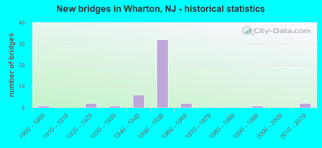
- New bridges - historical statistics
- 11900-1909
- 21920-1929
- 11930-1939
- 61940-1949
- 321950-1959
- 21960-1969
- 11990-1999
- 22010-2019

- Reconstructed bridges - Historical Statistics
- 11940-1949
- 01950-1959
- 01960-1969
- 31970-1979
- 41980-1989
- 11990-1999
- 22000-2009
- 12010-2019
- 12020-2022


- Bridge Condition - Deck
- 2.9%Excellent
- 2.9%Very good
- 17.6%Good
- 44.1%Satisfactory
- 23.5%Fair
- 5.9%Poor
- 2.9%Serious

- Bridge Condition - Superstructure
- 5.9%Excellent
- 11.8%Very good
- 5.9%Good
- 41.2%Satisfactory
- 26.5%Fair
- 8.8%Poor

- Bridge Condition - Substructure
- 5.9%Very good
- 17.6%Good
- 35.3%Satisfactory
- 35.3%Fair
- 5.9%Poor

- Bridge Condition - Channel
- 11.8%Very good
- 58.8%Good
- 11.8%Satisfactory
- 11.8%Fair
- 5.9%Poor
Find on map >> Show street view
Structure Number: 1400832, Location: 0.21 MI WEST OF NJ 15 (Lat: 40.931189, Lng: -74.594781), Route carried "on" structure: City street , Year Built: 2014, Status: Open, Structure Length: 1.68m (5.51ft), Average Daily Traffic: 5,651 (year 2021), Truck Traffic: 3%, Average Future Daily Traffic: 6,781 (year 2041), Design Load: HL 93, Features Intersected: ROCKAWAY RIVER, Facility Carried by Structure: BERKSHIRE VALLEY R
Minimum Vertical Clearance: 30+ m (98+ ft), Kilometerpoint: 4.635, Lanes on structure: 2, Owner: County Highway Agency, Approaching Roadway Width: 12.2m (40.0ft), Skew: 1 degrees, Material/Design: Prestressed concrete, Design/Construction: Box Beam or Girders - Multiple, Number Of Spans In Main Unit: 1, Length of Maximum Span: 15.2m (49.9ft), Curb or Sidewalk Widths: Left: 0.0m, Right: 1.8m (5.9ft), Curb-To-Curb Width: 11.5m (37.7ft), Out-to-Out Width: 14.5m (47.6ft)
Condition: Deck: Good, Superstructure: Very good, Substructure: Very good, Channel: Good, Operating Rating: 96.9 metric tons, Method Used To Determine Operating Rating: Load and Resistance Factor Rating (LRFR) rating reported by rating factor(RF) method using HL-93 loadings, Inventory Rating: 96.9 metric tons, Method Used To Determine Inventory Rating: Load and Resistance Factor Rating (LRFR) rating reported by rating factor(RF) method using HL-93 loadings, Structural Evaluation: Equal to present desirable criteria, Deck Geometry: Meets minimum limits, Waterway Adequacy: Superior to present desirable criteria, Approach Roadway Alignment: Better than present minimum criteria, Designated Inspection Frequency: Every 24 months, Inspection Date: October 2021, Deck Structure Type: Concrete Cast-file-Place, Wearing Surface/Protective System: Wearing Surface: Monolithic Concrete, Deck Protection: Epoxy Coated Reinforcing
Find on map >> Show street view
Structure Number: 1400965, Location: 0.5 MI. SOUTH OF RTE 80 (Lat: 40.904719, Lng: -74.599281), Route carried "on" structure: County highway 642, Year Built: 1928, Year Reconstructed: 1994, Status: Open, Structure Length: 1.68m (5.51ft), Average Daily Traffic: 5,739 (year 2021), Truck Traffic: 4%, Average Future Daily Traffic: 7,003 (year 2041), Design Load: HS 25 or greater, Features Intersected: ROCKAWAY RIVER
Minimum Vertical Clearance: 30+ m (98+ ft), Kilometerpoint: 5.488, Lanes on structure: 2, Owner: County Highway Agency, Approaching Roadway Width: 9.4m (30.8ft), Material/Design: Prestressed concrete, Design/Construction: Box Beam or Girders - Multiple, Number Of Spans In Main Unit: 1, Length of Maximum Span: 16.2m (53.1ft), Curb or Sidewalk Widths: Left: 0.0m, Right: 1.8m (5.9ft), Curb-To-Curb Width: 9.8m (32.2ft), Out-to-Out Width: 12.4m (40.7ft)
Condition: Deck: Satisfactory, Superstructure: Satisfactory, Substructure: Fair, Channel: Good, Inventory Rating: 61.7 metric tons, Method Used To Determine Inventory Rating: Load Factor (LF), Structural Evaluation: Somewhat better than minimum adequacy, Deck Geometry: Meets minimum limits, Waterway Adequacy: Superior to present desirable criteria, Approach Roadway Alignment: Equal to present desirable criteria, Length Of Structure Improvement: 1.68m (5.51ft), Designated Inspection Frequency: Every 24 months, Inspection Date: June 2021, Bridge Improvement Cost: $115,000, Total Project Cost: $259,000 ( Estimate for 2021), Deck Structure Type: Concrete Cast-file-Place, Wearing Surface/Protective System: Wearing Surface: Monolithic Concrete, Deck Protection: Epoxy Coated Reinforcing
Find on map >> Show street view
Structure Number: 1400992, Location: .2 MI EAST OF RANDOLPH AV (Lat: 40.873689, Lng: -74.592550), Route carried "on" structure: City street , Year Built: 1953, Year Reconstructed: 1989, Status: Open, Structure Length: 1.04m (3.41ft), Average Daily Traffic: 158 (year 2021), Truck Traffic: 1%, Average Future Daily Traffic: 193 (year 2041), Features Intersected: JACKSON BROOK, Facility Carried by Structure: INDIAN FALLS RD
Minimum Vertical Clearance: 30+ m (98+ ft), Kilometerpoint: 0.000, Lanes on structure: 2, Owner: County Highway Agency, Approaching Roadway Width: 5.5m (18.0ft), Skew: 1 degrees, Material/Design: Steel continuous, Design/Construction: Stringer/Multi-beam, Number Of Spans In Main Unit: 2, Length of Maximum Span: 4.6m (15.1ft), Curb-To-Curb Width: 5.5m (18.0ft), Out-to-Out Width: 5.7m (18.7ft)
Condition: Deck: Fair, Superstructure: Fair, Substructure: Fair, Channel: Fair, Operating Rating: 61.7 metric tons, Method Used To Determine Operating Rating: Load Factor (LF), Inventory Rating: 37.2 metric tons, Method Used To Determine Inventory Rating: Load Factor (LF), Structural Evaluation: Somewhat better than minimum adequacy, Deck Geometry: High priority of corrective action, Waterway Adequacy: Meets minimum limits, Approach Roadway Alignment: Somewhat better than minimum adequacy, Length Of Structure Improvement: 1.04m (3.41ft), Designated Inspection Frequency: Every 24 months, Inspection Date: June 2021, Bridge Improvement Cost: $172,000, Roadway Improvement Cost: $17,000, Total Project Cost: $505,000 ( Estimate for 2021), Deck Structure Type: Corrugated Steel, Wearing Surface/Protective System: Wearing Surface: Bituminous
Find on map >> Show street view
Structure Number: 1400999, Location: 0.25 MI S OF CO 642 (Lat: 40.903861, Lng: -74.589961), Route carried "on" structure: City street , Year Built: 2012, Status: Open, Structure Length: 1.52m (4.99ft), Average Daily Traffic: 1,884 (year 2021), Truck Traffic: 3%, Average Future Daily Traffic: 2,299 (year 2041), Design Load: HS 25 or greater, Features Intersected: ROCKAWAY RIVER, Facility Carried by Structure: W CENTRAL AVE
Minimum Vertical Clearance: 30+ m (98+ ft), Kilometerpoint: 0.000, Lanes on structure: 2, Owner: County Highway Agency, Approaching Roadway Width: 7.9m (25.9ft), Material/Design: Prestressed concrete, Design/Construction: Slab, Number Of Spans In Main Unit: 1, Length of Maximum Span: 14.0m (45.9ft), Curb or Sidewalk Widths: Left: 1.6m (5.2ft), Right: 0.0m, Curb-To-Curb Width: 7.9m (25.9ft), Out-to-Out Width: 10.5m (34.4ft)
Condition: Deck: Good, Superstructure: Good, Substructure: Very good, Channel: Very good, Inventory Rating: 55.3 metric tons, Method Used To Determine Inventory Rating: Load Factor (LF), Structural Evaluation: Better than present minimum criteria, Deck Geometry: Meets minimum limits, Waterway Adequacy: Equal to present desirable criteria, Approach Roadway Alignment: Equal to present desirable criteria, Designated Inspection Frequency: Every 24 months, Inspection Date: August 2021, Deck Structure Type: Concrete Cast-file-Place, Wearing Surface/Protective System: Deck Protection: Epoxy Coated Reinforcing
Find on map >> Show street view
Structure Number: 1401002, Location: .3 MILES S OF RTE 46 (Lat: 40.880631, Lng: -74.655669), Route carried "on" structure: City street , Year Built: 1925, Year Reconstructed: 1977, Status: Open, Structure Length: 0.88m (2.89ft), Average Daily Traffic: 2,931 (year 2021), Truck Traffic: 1%, Average Future Daily Traffic: 3,577 (year 2041), Features Intersected: LEDGEWOOD BROOK, Facility Carried by Structure: EMMANS ROAD
Minimum Vertical Clearance: 30+ m (98+ ft), Kilometerpoint: 0.000, Lanes on structure: 2, Owner: County Highway Agency, Approaching Roadway Width: 8.5m (27.9ft), Skew: 2 degrees, Material/Design: Steel continuous, Design/Construction: Stringer/Multi-beam, Number Of Spans In Main Unit: 2, Length of Maximum Span: 4.0m (13.1ft), Curb or Sidewalk Widths: Left: 1.2m (3.9ft), Right: 1.2m (3.9ft), Curb-To-Curb Width: 10.5m (34.4ft), Out-to-Out Width: 14.0m (45.9ft)
Condition: Deck: Fair, Superstructure: Fair, Substructure: Satisfactory, Channel: Poor, Operating Rating: 84.4 metric tons, Method Used To Determine Operating Rating: Load Factor (LF), Inventory Rating: 49.9 metric tons, Method Used To Determine Inventory Rating: Load Factor (LF), Structural Evaluation: Somewhat better than minimum adequacy, Deck Geometry: Somewhat better than minimum adequacy, Waterway Adequacy: Equal to present desirable criteria, Approach Roadway Alignment: Equal to present desirable criteria, Designated Inspection Frequency: Every 24 months, Inspection Date: August 2021, Deck Structure Type: Concrete Cast-file-Place, Wearing Surface/Protective System: Wearing Surface: Monolithic Concrete
Find on map >> Show street view
Structure Number: 1401004, Location: .5 MILES SOUTH OF I-80 (Lat: 40.903561, Lng: -74.578139), Route carried "on" structure: County highway 634, Year Built: 1950, Status: Open, Structure Length: 1.71m (5.61ft), Average Daily Traffic: 11,252 (year 2021), Truck Traffic: 4%, Average Future Daily Traffic: 13,730 (year 2041), Features Intersected: ROCKAWAY RIVER
Minimum Vertical Clearance: 30+ m (98+ ft), Kilometerpoint: 2.237, Lanes on structure: 2, Owner: County Highway Agency, Approaching Roadway Width: 9.1m (29.9ft), Material/Design: Steel, Design/Construction: Stringer/Multi-beam, Number Of Spans In Main Unit: 1, Length of Maximum Span: 15.8m (51.8ft), Curb or Sidewalk Widths: Left: 1.5m (4.9ft), Right: 1.5m (4.9ft), Curb-To-Curb Width: 9.2m (30.2ft), Out-to-Out Width: 12.8m (42.0ft)
Condition: Deck: Satisfactory, Superstructure: Satisfactory, Substructure: Satisfactory, Channel: Satisfactory, Operating Rating: 46.3 metric tons, Method Used To Determine Operating Rating: Load Factor (LF), Inventory Rating: 28.1 metric tons, Method Used To Determine Inventory Rating: Load Factor (LF), Structural Evaluation: Equal to present minimum criteria, Deck Geometry: High priority of corrective action, Waterway Adequacy: Superior to present desirable criteria, Approach Roadway Alignment: Equal to present minimum criteria, Length Of Structure Improvement: 1.71m (5.61ft), Designated Inspection Frequency: Every 24 months, Inspection Date: June 2021, Bridge Improvement Cost: $24,000, Roadway Improvement Cost: $6,000, Total Project Cost: $277,000 ( Estimate for 2021), Deck Structure Type: Concrete Cast-file-Place, Wearing Surface/Protective System: Wearing Surface: Latex Concrete
Find on map >> Show street view
Structure Number: 140315, Location: 0.40 MI SOUTH I-80 (Lat: 40.904319, Lng: -74.567819), Route carried "on" structure: State highway 15, Year Built: 1960, Year Reconstructed: 2004, Status: Open, Structure Length: 1.49m (4.89ft), Average Daily Traffic: 26,521 (year 2020), Truck Traffic: 4%, Average Future Daily Traffic: 31,825 (year 2040), Design Load: HS 20, Features Intersected: BRNT MEADOW (GRN PD) BRK
Minimum Vertical Clearance: 30+ m (98+ ft), Kilometerpoint: 2.655, Lanes on structure: 5, Owner: State Highway Agency, Approaching Roadway Width: 20.7m (67.9ft), Skew: 3 degrees, Material/Design: Prestressed concrete, Design/Construction: Stringer/Multi-beam, Number Of Spans In Main Unit: 1, Length of Maximum Span: 13.1m (43.0ft), Curb or Sidewalk Widths: Left: 1.8m (5.9ft), Right: 1.8m (5.9ft), Curb-To-Curb Width: 20.6m (67.6ft), Out-to-Out Width: 25.6m (84.0ft)
Condition: Deck: Fair, Superstructure: Satisfactory, Substructure: Fair, Channel: Good, Operating Rating: 28.1 metric tons, Method Used To Determine Operating Rating: Load Factor (LF), Inventory Rating: 17.2 metric tons, Method Used To Determine Inventory Rating: Load Factor (LF), Structural Evaluation: Meets minimum limits, Deck Geometry: Somewhat better than minimum adequacy, Waterway Adequacy: Better than present minimum criteria, Approach Roadway Alignment: Better than present minimum criteria, Length Of Structure Improvement: 1.49m (4.89ft), Designated Inspection Frequency: Every 24 months, Inspection Date: April 2020, Bridge Improvement Cost: $392,000, Total Project Cost: $451,000 ( Estimate for 2020), Deck Structure Type: Concrete Cast-file-Place, Wearing Surface/Protective System: Wearing Surface: Latex Concrete
Find on map >> Show street view
Structure Number: 1403152, Location: 0.24 MI. NO. OF I-80 (Lat: 40.911839, Lng: -74.574619), Route carried "on" structure: State highway 15, Year Built: 1958, Status: Open, Structure Length: 3.23m (10.60ft), Average Daily Traffic: 26,980 (year 2020), Truck Traffic: 4%, Average Future Daily Traffic: 32,376 (year 2040), Design Load: HS 20, Features Intersected: ABAND MT HOPE MINERAL RR
Minimum Vertical Clearance: 30+ m (98+ ft), Kilometerpoint: 3.701, Lanes on structure: 3, Base Highway Network: Yes, Owner: State Highway Agency, Approaching Roadway Width: 12.2m (40.0ft), Material/Design: Prestressed concrete, Design/Construction: Stringer/Multi-beam, Number Of Spans In Main Unit: 1, Length of Maximum Span: 30.5m (100.1ft), Curb or Sidewalk Widths: Left: 0.2m (0.7ft), Right: 0.2m (0.7ft), Curb-To-Curb Width: 12.2m (40.0ft), Out-to-Out Width: 14.1m (46.3ft)
Condition: Deck: Serious, Superstructure: Satisfactory, Substructure: Fair, Operating Rating: 46.3 metric tons, Method Used To Determine Operating Rating: Field evaluation and documented engineering judgment, Inventory Rating: 27.2 metric tons, Method Used To Determine Inventory Rating: Field evaluation and documented engineering judgment, Structural Evaluation: Somewhat better than minimum adequacy, Deck Geometry: Meets minimum limits, Approach Roadway Alignment: Equal to present minimum criteria, Length Of Structure Improvement: 3.23m (10.60ft), Designated Inspection Frequency: Every 24 months, Inspection Date: April 2020, Bridge Improvement Cost: $957,000, Roadway Improvement Cost: $95,000, Total Project Cost: $1,597,000 ( Estimate for 2020), Deck Structure Type: Concrete Cast-file-Place, Wearing Surface/Protective System: Wearing Surface: Monolithic Concrete
Find on map >> Show street view
Structure Number: 1403153, Location: 0.24 MI. NO. OF I-80 (Lat: 40.911269, Lng: -74.575269), Route carried "on" structure: State highway 15, Year Built: 1958, Year Reconstructed: 2012, Status: Open, Structure Length: 3.17m (10.40ft), Average Daily Traffic: 28,085 (year 2020), Truck Traffic: 4%, Average Future Daily Traffic: 33,702 (year 2040), Design Load: HS 20, Features Intersected: ABAND MT HOPE MINERAL RR
Minimum Vertical Clearance: 30+ m (98+ ft), Kilometerpoint: 3.701, Lanes on structure: 4, Base Highway Network: Yes, Owner: State Highway Agency, Approaching Roadway Width: 13.7m (44.9ft), Skew: 1 degrees, Material/Design: Prestressed concrete, Design/Construction: Stringer/Multi-beam, Number Of Spans In Main Unit: 1, Length of Maximum Span: 30.5m (100.1ft), Curb-To-Curb Width: 14.7m (48.2ft), Out-to-Out Width: 15.7m (51.5ft)
Condition: Deck: Good, Superstructure: Satisfactory, Substructure: Satisfactory, Operating Rating: 51.7 metric tons, Method Used To Determine Operating Rating: Field evaluation and documented engineering judgment, Inventory Rating: 30.8 metric tons, Method Used To Determine Inventory Rating: Field evaluation and documented engineering judgment, Structural Evaluation: Equal to present minimum criteria, Deck Geometry: High priority of replacement, Approach Roadway Alignment: Equal to present desirable criteria, Length Of Structure Improvement: 3.17m (10.40ft), Designated Inspection Frequency: Every 24 months, Inspection Date: April 2020, Bridge Improvement Cost: $168,000, Roadway Improvement Cost: $17,000, Total Project Cost: $242,000 ( Estimate for 2020), Deck Structure Type: Concrete Cast-file-Place, Wearing Surface/Protective System: Wearing Surface: Monolithic Concrete
Find on map >> Show street view
Structure Number: 1404151, Location: 0.46 MI. NO. OF 80 (Lat: 40.912550, Lng: -74.578181), Route carried "on" structure: State highway 15, Year Built: 1943, Status: Open, Structure Length: 1.65m (5.41ft), Average Daily Traffic: 28,085 (year 2020), Truck Traffic: 4%, Average Future Daily Traffic: 33,702 (year 2040), Features Intersected: RAMP TO NJ 15 NB
Minimum Vertical Clearance: 30+ m (98+ ft), Kilometerpoint: 3.991, Lanes on structure: 4, Lanes under structure: 2, Base Highway Network: Yes, Owner: State Highway Agency, Approaching Roadway Width: 13.4m (44.0ft), Skew: 3 degrees, Material/Design: Concrete, Design/Construction: Tee Beam, Number Of Spans In Main Unit: 1, Length of Maximum Span: 15.5m (50.9ft), Curb or Sidewalk Widths: Left: 2.4m (7.9ft), Right: 2.4m (7.9ft), Curb-To-Curb Width: 13.4m (44.0ft), Out-to-Out Width: 19.1m (62.7ft)
Condition: Deck: Satisfactory, Superstructure: Fair, Substructure: Fair, Operating Rating: 57.2 metric tons, Method Used To Determine Operating Rating: Load Factor (LF), Inventory Rating: 33.6 metric tons, Method Used To Determine Inventory Rating: Load Factor (LF), Structural Evaluation: Somewhat better than minimum adequacy, Deck Geometry: High priority of replacement, Underclear: Meets minimum limits, Approach Roadway Alignment: Equal to present desirable criteria, Length Of Structure Improvement: 1.65m (5.41ft), Designated Inspection Frequency: Every 24 months, Inspection Date: April 2020, Bridge Improvement Cost: $70,000, Roadway Improvement Cost: $35,000, Total Project Cost: $142,000 ( Estimate for 2020), Deck Structure Type: Concrete Cast-file-Place, Wearing Surface/Protective System: Wearing Surface: Monolithic Concrete
Find on map >> Show street view
Structure Number: 1404154, Location: 0.62 mi N of I-80 (Lat: 40.915181, Lng: -74.580631), Route carried "on" structure: City street , Year Built: 1943, Status: Open, Structure Length: 2.50m (8.20ft), Average Daily Traffic: 4,100 (year 2021), Truck Traffic: 1%, Average Future Daily Traffic: 4,920 (year 2041), Features Intersected: NJ 15 NB, Facility Carried by Structure: PARKER RD WB
Minimum Vertical Clearance: 30+ m (98+ ft), Kilometerpoint: 0.000, Lanes on structure: 2, Lanes under structure: 3, Owner: State Highway Agency, Approaching Roadway Width: 7.9m (25.9ft), Skew: 3 degrees, Material/Design: Concrete continuous, Design/Construction: Tee Beam, Number Of Spans In Main Unit: 3, Length of Maximum Span: 18.3m (60.0ft), Curb or Sidewalk Widths: Left: 2.6m (8.5ft), Right: 2.6m (8.5ft), Curb-To-Curb Width: 8.1m (26.6ft), Out-to-Out Width: 13.7m (44.9ft)
Condition: Deck: Poor, Superstructure: Poor, Substructure: Fair, Operating Rating: 51.7 metric tons, Method Used To Determine Operating Rating: Load Factor (LF), Inventory Rating: 30.8 metric tons, Method Used To Determine Inventory Rating: Load Factor (LF), Structural Evaluation: Meets minimum limits, Deck Geometry: High priority of replacement, Underclear: Meets minimum limits, Approach Roadway Alignment: Equal to present desirable criteria, Length Of Structure Improvement: 3.26m (10.70ft), Designated Inspection Frequency: Every 24 months, Inspection Date: July 2021, Bridge Improvement Cost: $1,710,000, Roadway Improvement Cost: $171,000, Total Project Cost: $2,646,000 ( Estimate for 2021), Deck Structure Type: Concrete Cast-file-Place, Wearing Surface/Protective System: Wearing Surface: Latex Concrete
Find on map >> Show street view
Structure Number: 1404155, Location: .63 MILES N OF I-80 (Lat: 40.915181, Lng: -74.580731), Route carried "on" structure: Ramp State highway 15, Year Built: 1943, Status: Open, Structure Length: 1.16m (3.81ft), Average Daily Traffic: 2,980 (year 2021), Truck Traffic: 1%, Average Future Daily Traffic: 3,640 (year 2041), Features Intersected: GREEN POND BROOK, Facility Carried by Structure: PARKER ROAD WB
Minimum Vertical Clearance: 30+ m (98+ ft), Kilometerpoint: 4.313, Lanes on structure: 2, Owner: State Highway Agency, Approaching Roadway Width: 8.2m (26.9ft), Skew: 3 degrees, Material/Design: Concrete, Design/Construction: Culvert, Number Of Spans In Main Unit: 1, Length of Maximum Span: 11.6m (38.1ft)
Condition: Channel: Good, Culverts: Satisfactory, Structural Evaluation: Equal to present minimum criteria, Waterway Adequacy: Superior to present desirable criteria, Approach Roadway Alignment: Equal to present minimum criteria, Designated Inspection Frequency: Every 24 months, Inspection Date: August 2021
Find on map >> Show street view
Structure Number: 1404156, Location: 0.84 MI. NORTH OF I-80 (Lat: 40.916289, Lng: -74.582039), Route carried "on" structure: State highway 15, Year Built: 1943, Status: Open, Structure Length: 1.37m (4.49ft), Average Daily Traffic: 27,218 (year 2020), Truck Traffic: 4%, Average Future Daily Traffic: 32,662 (year 2040), Features Intersected: GREEN POND BR ROCKAWAY R
Minimum Vertical Clearance: 30+ m (98+ ft), Kilometerpoint: 4.490, Lanes on structure: 4, Base Highway Network: Yes, Owner: State Highway Agency, Approaching Roadway Width: 13.4m (44.0ft), Skew: 4 degrees, Material/Design: Concrete, Design/Construction: Tee Beam, Number Of Spans In Main Unit: 1, Length of Maximum Span: 12.5m (41.0ft), Curb or Sidewalk Widths: Left: 2.4m (7.9ft), Right: 2.4m (7.9ft), Curb-To-Curb Width: 13.4m (44.0ft), Out-to-Out Width: 19.2m (63.0ft)
Condition: Deck: Fair, Superstructure: Fair, Substructure: Fair, Channel: Good, Operating Rating: 29.9 metric tons, Method Used To Determine Operating Rating: Load Factor (LF), Inventory Rating: 18.1 metric tons, Method Used To Determine Inventory Rating: Load Factor (LF), Structural Evaluation: Meets minimum limits, Deck Geometry: High priority of replacement, Waterway Adequacy: Equal to present desirable criteria, Approach Roadway Alignment: Equal to present desirable criteria, Length Of Structure Improvement: 1.37m (4.49ft), Designated Inspection Frequency: Every 24 months, Inspection Date: April 2020, Bridge Improvement Cost: $54,000, Roadway Improvement Cost: $37,000, Total Project Cost: $138,000 ( Estimate for 2020), Deck Structure Type: Concrete Cast-file-Place, Wearing Surface/Protective System: Wearing Surface: Bituminous
Find on map >> Show street view
Structure Number: 1404157, Location: 2.15 MI. NO. OF RT.80 (Lat: 40.934539, Lng: -74.590261), Route carried "on" structure: State highway 15, Year Built: 1964, Status: Open, Structure Length: 3.51m (11.52ft), Average Daily Traffic: 26,889 (year 2020), Truck Traffic: 4%, Average Future Daily Traffic: 32,267 (year 2040), Design Load: HS 20+Mod, Features Intersected: ROCKAWAY RIVER
Minimum Vertical Clearance: 30+ m (98+ ft), Kilometerpoint: 6.759, Lanes on structure: 2, Base Highway Network: Yes, Owner: State Highway Agency, Approaching Roadway Width: 11.9m (39.0ft), Skew: 1 degrees, Material/Design: Prestressed concrete, Design/Construction: Slab, Number Of Spans In Main Unit: 4, Length of Maximum Span: 9.8m (32.2ft), Curb or Sidewalk Widths: Left: 0.5m (1.6ft), Right: 1.8m (5.9ft), Curb-To-Curb Width: 11.9m (39.0ft), Out-to-Out Width: 14.8m (48.6ft)
Condition: Deck: Satisfactory, Superstructure: Fair, Substructure: Satisfactory, Channel: Fair, Operating Rating: 89.8 metric tons, Method Used To Determine Operating Rating: Load Factor (LF), Inventory Rating: 60.8 metric tons, Method Used To Determine Inventory Rating: Load Factor (LF), Structural Evaluation: Somewhat better than minimum adequacy, Deck Geometry: Better than present minimum criteria, Waterway Adequacy: Superior to present desirable criteria, Approach Roadway Alignment: Equal to present desirable criteria, Designated Inspection Frequency: Every 24 months, Inspection Date: March 2020, Deck Structure Type: Concrete Cast-file-Place, Wearing Surface/Protective System: Wearing Surface: Monolithic Concrete
Find on map >> Show street view
Structure Number: 1404158, Location: 2.2 MI. N. OF ROUTE 80 (Lat: 40.934461, Lng: -74.591489), Route carried "on" structure: State highway 15, Year Built: 1900, Year Reconstructed: 1947, Status: Open, Structure Length: 1.55m (5.09ft), Average Daily Traffic: 35,595 (year 2020), Truck Traffic: 4%, Average Future Daily Traffic: 19,267 (year 2040), Features Intersected: ROCKWAY RIVER
Minimum Vertical Clearance: 30+ m (98+ ft), Kilometerpoint: 6.759, Lanes on structure: 2, Base Highway Network: Yes, Owner: State Highway Agency, Approaching Roadway Width: 12.2m (40.0ft), Material/Design: Concrete continuous, Design/Construction: Slab, Number Of Spans In Main Unit: 3, Length of Maximum Span: 5.2m (17.1ft), Curb or Sidewalk Widths: Left: 0.0m, Right: 0.7m (2.3ft), Curb-To-Curb Width: 12.2m (40.0ft), Out-to-Out Width: 14.2m (46.6ft)
Condition: Deck: Poor, Superstructure: Poor, Substructure: Poor, Channel: Satisfactory, Operating Rating: 37.2 metric tons, Method Used To Determine Operating Rating: Load Factor (LF), Inventory Rating: 23.6 metric tons, Method Used To Determine Inventory Rating: Load Factor (LF), Structural Evaluation: Meets minimum limits, Deck Geometry: Better than present minimum criteria, Waterway Adequacy: Equal to present minimum criteria, Approach Roadway Alignment: Equal to present desirable criteria, Length Of Structure Improvement: 2.23m (7.32ft), Designated Inspection Frequency: Every 24 months, Inspection Date: March 2020, Bridge Improvement Cost: $900,000, Roadway Improvement Cost: $90,000, Total Project Cost: $1,439,000 ( Estimate for 2018), Deck Structure Type: Concrete Cast-file-Place, Wearing Surface/Protective System: Wearing Surface: Bituminous
Find on map >> Show street view
Structure Number: 1412171, Location: 1.9 MI WEST OF NJ 15 (Lat: 40.904561, Lng: -74.609989), Route carried "on" structure: Interstate 80, Year Built: 1959, Year Reconstructed: 2011, Status: Open, Structure Length: 6.04m (19.82ft), Average Daily Traffic: 58,755 (year 2021), Truck Traffic: 9%, Average Future Daily Traffic: 70,505 (year 2041), Design Load: HL 93, Features Intersected: BERKSHIRE VAL. RD & RR
Minimum Vertical Clearance: 30+ m (98+ ft), Kilometerpoint: 51.483, Lanes on structure: 3, Lanes under structure: 2, Base Highway Network: Yes, Owner: State Highway Agency, Approaching Roadway Width: 16.5m (54.1ft), Skew: 1 degrees, Material/Design: Prestressed concrete, Design/Construction: Stringer/Multi-beam, Number Of Spans In Main Unit: 4, Length of Maximum Span: 18.6m (61.0ft), Curb-To-Curb Width: 16.5m (54.1ft), Out-to-Out Width: 17.4m (57.1ft)
Condition: Deck: Good, Superstructure: Very good, Substructure: Good, Operating Rating: 59.6 metric tons, Method Used To Determine Operating Rating: Load and Resistance Factor Rating (LRFR) rating reported by rating factor(RF) method using HL-93 loadings, Inventory Rating: 31.1 metric tons, Method Used To Determine Inventory Rating: Load and Resistance Factor Rating (LRFR) rating reported by rating factor(RF) method using HL-93 loadings, Structural Evaluation: Better than present minimum criteria, Deck Geometry: Equal to present minimum criteria, Underclear: Superior to present desirable criteria, Approach Roadway Alignment: Equal to present desirable criteria, Designated Inspection Frequency: Every 24 months, Inspection Date: August 2021, Deck Structure Type: Concrete Cast-file-Place, Wearing Surface/Protective System: Deck Protection: Epoxy Coated Reinforcing
Find on map >> Show street view
Structure Number: 1412172, Location: 1.9 MI WEST OF NJ 15 (Lat: 40.905189, Lng: -74.609419), Route carried "on" structure: Interstate 80, Year Built: 1959, Year Reconstructed: 2010, Status: Open, Structure Length: 5.67m (18.60ft), Average Daily Traffic: 58,755 (year 2021), Truck Traffic: 9%, Average Future Daily Traffic: 70,505 (year 2041), Design Load: HL 93, Features Intersected: BERKSHIRE VLY RD & AB.RR
Minimum Vertical Clearance: 30+ m (98+ ft), Kilometerpoint: 51.483, Lanes on structure: 4, Lanes under structure: 2, Base Highway Network: Yes, Owner: State Highway Agency, Approaching Roadway Width: 16.5m (54.1ft), Skew: 1 degrees, Material/Design: Prestressed concrete, Design/Construction: Stringer/Multi-beam, Number Of Spans In Main Unit: 4, Length of Maximum Span: 18.6m (61.0ft), Curb-To-Curb Width: 16.5m (54.1ft), Out-to-Out Width: 17.4m (57.1ft)
Condition: Deck: Good, Superstructure: Very good, Substructure: Good, Operating Rating: 60.6 metric tons, Method Used To Determine Operating Rating: Load and Resistance Factor Rating (LRFR) rating reported by rating factor(RF) method using HL-93 loadings, Inventory Rating: 31.1 metric tons, Method Used To Determine Inventory Rating: Load and Resistance Factor Rating (LRFR) rating reported by rating factor(RF) method using HL-93 loadings, Structural Evaluation: Better than present minimum criteria, Deck Geometry: High priority of replacement, Underclear: Superior to present desirable criteria, Approach Roadway Alignment: Equal to present desirable criteria, Length Of Structure Improvement: 5.67m (18.60ft), Designated Inspection Frequency: Every 24 months, Inspection Date: August 2021, Bridge Improvement Cost: $930,000, Roadway Improvement Cost: $60,000, Total Project Cost: $1,432,000 ( Estimate for 2021), Deck Structure Type: Concrete Cast-file-Place, Wearing Surface/Protective System: Deck Protection: Epoxy Coated Reinforcing
Find on map >> Show street view
Structure Number: 1412173, Location: 1.6 MI WEST OF RT 15 JCT (Lat: 40.906831, Lng: -74.602100), Route carried "on" structure: City street , Year Built: 1959, Year Reconstructed: 1986, Status: Open, Structure Length: 5.24m (17.19ft), Average Daily Traffic: 1,472 (year 2020), Truck Traffic: 1%, Average Future Daily Traffic: 1,792 (year 2040), Design Load: HS 20+Mod, Features Intersected: I-80, Facility Carried by Structure: MILL ROAD
Minimum Vertical Clearance: 30+ m (98+ ft), Kilometerpoint: 0.000, Lanes on structure: 2, Lanes under structure: 6, Owner: State Highway Agency, Approaching Roadway Width: 9.1m (29.9ft), Material/Design: Prestressed concrete, Design/Construction: Box Beam or Girders - Multiple, Number Of Spans In Main Unit: 2, Length of Maximum Span: 25.3m (83.0ft), Curb or Sidewalk Widths: Left: 1.8m (5.9ft), Right: 0.0m, Curb-To-Curb Width: 9.1m (29.9ft), Out-to-Out Width: 11.7m (38.4ft)
Condition: Deck: Satisfactory, Superstructure: Satisfactory, Substructure: Satisfactory, Operating Rating: 52.6 metric tons, Method Used To Determine Operating Rating: Load Factor (LF), Inventory Rating: 30.8 metric tons, Method Used To Determine Inventory Rating: Load Factor (LF), Structural Evaluation: Equal to present minimum criteria, Deck Geometry: Somewhat better than minimum adequacy, Underclear: Somewhat better than minimum adequacy, Approach Roadway Alignment: Equal to present minimum criteria, Designated Inspection Frequency: Every 24 months, Inspection Date: March 2020, Deck Structure Type: Concrete Cast-file-Place, Wearing Surface/Protective System: Deck Protection: Epoxy Coated Reinforcing
Find on map >> Show street view
Structure Number: 1412174, Location: 1.95 MI E OF EXIT 30 JCT (Lat: 40.907569, Lng: -74.599631), Route carried "on" structure: Interstate 80, Year Built: 1959, Year Reconstructed: 2020, Status: Open, Structure Length: 5.85m (19.19ft), Average Daily Traffic: 57,572 (year 2020), Truck Traffic: 9%, Average Future Daily Traffic: 70,238 (year 2040), Design Load: HS 20, Features Intersected: ROCKAWAY RIVER
Minimum Vertical Clearance: 30+ m (98+ ft), Kilometerpoint: 52.416, Lanes on structure: 3, Base Highway Network: Yes, Owner: State Highway Agency, Approaching Roadway Width: 16.2m (53.1ft), Skew: 4 degrees, Material/Design: Steel, Design/Construction: Stringer/Multi-beam, Number Of Spans In Main Unit: 3, Length of Maximum Span: 18.3m (60.0ft), Curb-To-Curb Width: 16.3m (53.5ft), Out-to-Out Width: 17.2m (56.4ft)
Condition: Deck: Excellent, Superstructure: Excellent, Substructure: Good, Channel: Good, Operating Rating: 52.6 metric tons, Method Used To Determine Operating Rating: Load Factor (LF), Inventory Rating: 31.8 metric tons, Method Used To Determine Inventory Rating: Load Factor (LF), Structural Evaluation: Better than present minimum criteria, Deck Geometry: Equal to present minimum criteria, Waterway Adequacy: Better than present minimum criteria, Approach Roadway Alignment: Equal to present desirable criteria, Length Of Structure Improvement: 5.85m (19.19ft), Designated Inspection Frequency: Every 24 months, Underwater Inspection Frequency: Every 48 months, Inspection Date: March 2020, Underwater Inspection Date: May 2018, Bridge Improvement Cost: $1,844,000, Roadway Improvement Cost: $120,000, Total Project Cost: $2,913,000 ( Estimate for 2018), Deck Structure Type: Concrete Cast-file-Place
Find on map >> Show street view
Structure Number: 1412175, Location: 1.45 MI WEST OF NJ RT 15 (Lat: 40.908369, Lng: -74.598700), Route carried "on" structure: Interstate 80, Year Built: 1959, Year Reconstructed: 2021, Status: Open, Structure Length: 5.79m (19.00ft), Average Daily Traffic: 58,300 (year 2020), Truck Traffic: 9%, Average Future Daily Traffic: 70,000 (year 2040), Design Load: HL 93, Features Intersected: ROCKAWAY RIVER
Minimum Vertical Clearance: 0.00m, Kilometerpoint: 52.416, Lanes on structure: 3, Base Highway Network: Yes, Owner: State Highway Agency, Approaching Roadway Width: 16.5m (54.1ft), Skew: 4 degrees, Material/Design: Steel continuous, Design/Construction: Stringer/Multi-beam, Number Of Spans In Main Unit: 3, Length of Maximum Span: 18.6m (61.0ft), Curb-To-Curb Width: 16.6m (54.5ft), Out-to-Out Width: 17.5m (57.4ft)
Condition: Deck: Very good, Superstructure: Excellent, Substructure: Good, Channel: Good, Operating Rating: 51.5 metric tons, Method Used To Determine Operating Rating: Load and Resistance Factor Rating (LRFR) rating reported by rating factor(RF) method using HL-93 loadings, Inventory Rating: 39.5 metric tons, Method Used To Determine Inventory Rating: Load and Resistance Factor Rating (LRFR) rating reported by rating factor(RF) method using HL-93 loadings, Structural Evaluation: Better than present minimum criteria, Deck Geometry: Equal to present minimum criteria, Waterway Adequacy: Equal to present desirable criteria, Approach Roadway Alignment: Equal to present desirable criteria, Designated Inspection Frequency: Every 24 months, Underwater Inspection Frequency: Every 48 months, Inspection Date: July 2020, Underwater Inspection Date: September 2021, Bridge Improvement Cost: $1,898,000, Roadway Improvement Cost: $50,000, Total Project Cost: $2,240,000 ( Estimate for 2018), Deck Structure Type: Concrete Cast-file-Place, Wearing Surface/Protective System: Deck Protection: Epoxy Coated Reinforcing
Find on map >> Show street view
Structure Number: 1412176, Location: 0.5 MI W OF NJ 15 (Lat: 40.907731, Lng: -74.580419), Route carried "on" structure: Interstate 80, Year Built: 1959, Status: Open, Structure Length: 2.13m (6.99ft), Average Daily Traffic: 51,800 (year 2020), Truck Traffic: 9%, Average Future Daily Traffic: 63,200 (year 2040), Design Load: HS 20, Features Intersected: NORTH MAIN ST. (CR 634)
Minimum Vertical Clearance: 30+ m (98+ ft), Kilometerpoint: 54.042, Lanes on structure: 4, Lanes under structure: 3, Base Highway Network: Yes, Owner: State Highway Agency, Approaching Roadway Width: 15.8m (51.8ft), Skew: 1 degrees, Material/Design: Prestressed concrete, Design/Construction: Stringer/Multi-beam, Number Of Spans In Main Unit: 1, Length of Maximum Span: 19.8m (65.0ft), Curb or Sidewalk Widths: Left: 0.5m (1.6ft), Right: 0.5m (1.6ft), Curb-To-Curb Width: 16.0m (52.5ft), Out-to-Out Width: 17.6m (57.7ft)
Condition: Deck: Fair, Superstructure: Fair, Substructure: Fair, Operating Rating: 47.2 metric tons, Method Used To Determine Operating Rating: Load Factor (LF), Inventory Rating: 29.0 metric tons, Method Used To Determine Inventory Rating: Load Factor (LF), Structural Evaluation: Somewhat better than minimum adequacy, Deck Geometry: High priority of replacement, Underclear: Somewhat better than minimum adequacy, Approach Roadway Alignment: Equal to present desirable criteria, Length Of Structure Improvement: 2.13m (6.99ft), Designated Inspection Frequency: Every 24 months, Inspection Date: March 2020, Bridge Improvement Cost: $98,000, Roadway Improvement Cost: $65,000, Total Project Cost: $277,000 ( Estimate for 2020), Deck Structure Type: Concrete Cast-file-Place, Wearing Surface/Protective System: Wearing Surface: Bituminous
Find on map >> Show street view
Structure Number: 1412177, Location: 0.5 Mi. West of NJ 15 (Lat: 40.907931, Lng: -74.580139), Route carried "on" structure: Interstate 80, Year Built: 1959, Status: Open, Structure Length: 2.10m (6.89ft), Average Daily Traffic: 50,200 (year 2020), Truck Traffic: 9%, Average Future Daily Traffic: 61,250 (year 2040), Design Load: HS 20, Features Intersected: NORTH MAIN ST. (CR 634)
Minimum Vertical Clearance: 30+ m (98+ ft), Kilometerpoint: 54.042, Lanes on structure: 3, Lanes under structure: 3, Base Highway Network: Yes, Owner: State Highway Agency, Approaching Roadway Width: 15.5m (50.9ft), Skew: 1 degrees, Material/Design: Prestressed concrete, Design/Construction: Stringer/Multi-beam, Number Of Spans In Main Unit: 1, Length of Maximum Span: 19.8m (65.0ft), Curb or Sidewalk Widths: Left: 0.5m (1.6ft), Right: 0.5m (1.6ft), Curb-To-Curb Width: 15.6m (51.2ft), Out-to-Out Width: 17.3m (56.8ft)
Condition: Deck: Fair, Superstructure: Fair, Substructure: Fair, Operating Rating: 49.0 metric tons, Method Used To Determine Operating Rating: Load Factor (LF), Inventory Rating: 29.9 metric tons, Method Used To Determine Inventory Rating: Load Factor (LF), Structural Evaluation: Somewhat better than minimum adequacy, Deck Geometry: Somewhat better than minimum adequacy, Underclear: Equal to present minimum criteria, Approach Roadway Alignment: Equal to present desirable criteria, Designated Inspection Frequency: Every 24 months, Inspection Date: March 2020, Deck Structure Type: Concrete Cast-file-Place, Wearing Surface/Protective System: Wearing Surface: Bituminous
Find on map >> Show street view
Structure Number: 1412178, Location: 0.15 Mi. WEST OF RT 15 (Lat: 40.908389, Lng: -74.575381), Route carried "on" structure: Interstate 80, Year Built: 1959, Status: Open, Structure Length: 3.29m (10.79ft), Average Daily Traffic: 51,750 (year 2020), Truck Traffic: 9%, Average Future Daily Traffic: 63,140 (year 2040), Design Load: HS 20+Mod, Features Intersected: ABANDONED MT HOPE MIN RR
Minimum Vertical Clearance: 30+ m (98+ ft), Kilometerpoint: 54.492, Lanes on structure: 3, Base Highway Network: Yes, Owner: State Highway Agency, Approaching Roadway Width: 15.8m (51.8ft), Skew: 1 degrees, Material/Design: Prestressed concrete, Design/Construction: Stringer/Multi-beam, Number Of Spans In Main Unit: 3, Length of Maximum Span: 10.1m (33.1ft), Curb-To-Curb Width: 15.8m (51.8ft), Out-to-Out Width: 17.5m (57.4ft)
Condition: Deck: Satisfactory, Superstructure: Fair, Substructure: Fair, Operating Rating: 46.3 metric tons, Method Used To Determine Operating Rating: Load Factor (LF), Inventory Rating: 27.2 metric tons, Method Used To Determine Inventory Rating: Load Factor (LF), Structural Evaluation: Somewhat better than minimum adequacy, Deck Geometry: Somewhat better than minimum adequacy, Approach Roadway Alignment: Equal to present desirable criteria, Designated Inspection Frequency: Every 24 months, Inspection Date: April 2020, Deck Structure Type: Concrete Cast-file-Place, Wearing Surface/Protective System: Wearing Surface: Bituminous
Find on map >> Show street view
Structure Number: 1412179, Location: 0.15 Mi. WEST OF RT 15 (Lat: 40.908881, Lng: -74.574931), Route carried "on" structure: Interstate 80, Year Built: 1959, Status: Open, Structure Length: 3.29m (10.79ft), Average Daily Traffic: 50,160 (year 2020), Truck Traffic: 9%, Average Future Daily Traffic: 61,195 (year 2040), Design Load: HS 20+Mod, Features Intersected: ABANDONED MT HOPE MIN RR
Minimum Vertical Clearance: 30+ m (98+ ft), Kilometerpoint: 54.492, Lanes on structure: 3, Base Highway Network: Yes, Owner: State Highway Agency, Approaching Roadway Width: 15.8m (51.8ft), Skew: 1 degrees, Material/Design: Prestressed concrete, Design/Construction: Stringer/Multi-beam, Number Of Spans In Main Unit: 3, Length of Maximum Span: 10.1m (33.1ft), Curb-To-Curb Width: 15.8m (51.8ft), Out-to-Out Width: 17.5m (57.4ft)
Condition: Deck: Satisfactory, Superstructure: Fair, Substructure: Fair, Operating Rating: 46.3 metric tons, Method Used To Determine Operating Rating: Load Factor (LF), Inventory Rating: 27.2 metric tons, Method Used To Determine Inventory Rating: Load Factor (LF), Structural Evaluation: Somewhat better than minimum adequacy, Deck Geometry: Somewhat better than minimum adequacy, Approach Roadway Alignment: Equal to present desirable criteria, Designated Inspection Frequency: Every 24 months, Inspection Date: April 2020, Deck Structure Type: Concrete Cast-file-Place, Wearing Surface/Protective System: Wearing Surface: Bituminous
Find on map >> Show street view
Structure Number: 141315, Location: AT I-80 EXIT 34 (Lat: 40.908981, Lng: -74.572031), Route carried "on" structure: Interstate 80, Year Built: 1959, Status: Open, Structure Length: 2.93m (9.61ft), Average Daily Traffic: 54,500 (year 2021), Truck Traffic: 9%, Average Future Daily Traffic: 65,400 (year 2041), Design Load: HS 20, Features Intersected: NJ 15
Minimum Vertical Clearance: 30+ m (98+ ft), Kilometerpoint: 54.766, Lanes on structure: 3, Lanes under structure: 3, Base Highway Network: Yes, Owner: State Highway Agency, Approaching Roadway Width: 15.8m (51.8ft), Material/Design: Prestressed concrete, Design/Construction: Stringer/Multi-beam, Number Of Spans In Main Unit: 2, Length of Maximum Span: 14.0m (45.9ft), Curb or Sidewalk Widths: Left: 0.5m (1.6ft), Right: 0.5m (1.6ft), Curb-To-Curb Width: 15.8m (51.8ft), Out-to-Out Width: 17.5m (57.4ft)
Condition: Deck: Fair, Superstructure: Satisfactory, Substructure: Satisfactory, Operating Rating: 57.2 metric tons, Method Used To Determine Operating Rating: Load Factor (LF), Inventory Rating: 34.5 metric tons, Method Used To Determine Inventory Rating: Load Factor (LF), Structural Evaluation: Equal to present minimum criteria, Deck Geometry: Somewhat better than minimum adequacy, Underclear: Meets minimum limits, Approach Roadway Alignment: Equal to present desirable criteria, Designated Inspection Frequency: Every 24 months, Inspection Date: September 2021, Deck Structure Type: Concrete Cast-file-Place, Wearing Surface/Protective System: Wearing Surface: Bituminous
Find on map >> Show street view
Structure Number: 1413151, Location: 3.4 MI E OF CR 615 (Lat: 40.909211, Lng: -74.572161), Route carried "on" structure: Interstate 80, Year Built: 1959, Status: Open, Structure Length: 3.29m (10.79ft), Average Daily Traffic: 54,500 (year 2021), Truck Traffic: 9%, Average Future Daily Traffic: 65,400 (year 2041), Design Load: HS 20, Features Intersected: NJ 15
Minimum Vertical Clearance: 30+ m (98+ ft), Kilometerpoint: 54.766, Lanes on structure: 3, Lanes under structure: 3, Base Highway Network: Yes, Owner: State Highway Agency, Approaching Roadway Width: 15.8m (51.8ft), Material/Design: Prestressed concrete, Design/Construction: Stringer/Multi-beam, Number Of Spans In Main Unit: 2, Length of Maximum Span: 14.0m (45.9ft), Curb or Sidewalk Widths: Left: 0.5m (1.6ft), Right: 0.5m (1.6ft), Curb-To-Curb Width: 15.8m (51.8ft), Out-to-Out Width: 17.5m (57.4ft)
Condition: Deck: Satisfactory, Superstructure: Satisfactory, Substructure: Satisfactory, Operating Rating: 58.1 metric tons, Method Used To Determine Operating Rating: Load Factor (LF), Inventory Rating: 34.5 metric tons, Method Used To Determine Inventory Rating: Load Factor (LF), Structural Evaluation: Equal to present minimum criteria, Deck Geometry: Somewhat better than minimum adequacy, Underclear: Meets minimum limits, Approach Roadway Alignment: Equal to present desirable criteria, Designated Inspection Frequency: Every 24 months, Inspection Date: September 2021, Bridge Improvement Cost: $2,329,000, Roadway Improvement Cost: $50,000, Total Project Cost: $3,306,000 ( Estimate for 2019), Deck Structure Type: Concrete Cast-file-Place, Wearing Surface/Protective System: Wearing Surface: Bituminous
Find on map >> Show street view
Structure Number: 1413152, Location: .15 M E OF MT HOPE MIN RR (Lat: 40.910489, Lng: -74.572831), Route carried "on" structure: Ramp Interstate 80, Year Built: 1959, Year Reconstructed: 1986, Status: Open, Structure Length: 3.08m (10.10ft), Average Daily Traffic: 6,582 (year 2021), Truck Traffic: 9%, Average Future Daily Traffic: 8,031 (year 2041), Design Load: HS 20, Features Intersected: NJ 15 NB
Minimum Vertical Clearance: 30+ m (98+ ft), Kilometerpoint: 54.750, Lanes on structure: 2, Lanes under structure: 1, Owner: State Highway Agency, Approaching Roadway Width: 11.3m (37.1ft), Skew: 6 degrees, Material/Design: Prestressed concrete, Design/Construction: Stringer/Multi-beam, Number Of Spans In Main Unit: 1, Length of Maximum Span: 26.5m (86.9ft), Curb-To-Curb Width: 11.3m (37.1ft), Out-to-Out Width: 12.4m (40.7ft)
Condition: Deck: Satisfactory, Superstructure: Satisfactory, Substructure: Fair, Inventory Rating: 64.4 metric tons, Method Used To Determine Inventory Rating: Load Factor (LF), Structural Evaluation: Somewhat better than minimum adequacy, Deck Geometry: Superior to present desirable criteria, Underclear: Equal to present minimum criteria, Approach Roadway Alignment: Equal to present desirable criteria, Designated Inspection Frequency: Every 24 months, Inspection Date: May 2021, Deck Structure Type: Concrete Cast-file-Place, Wearing Surface/Protective System: Wearing Surface: Latex Concrete, Deck Protection: Epoxy Coated Reinforcing
Find on map >> Show street view
Structure Number: 1413153, Location: AT I-80 EXIT 34 (Lat: 40.909489, Lng: -74.569100), Route carried "on" structure: Interstate 80, Year Built: 1959, Status: Open, Structure Length: 3.47m (11.38ft), Average Daily Traffic: 54,500 (year 2021), Truck Traffic: 9%, Average Future Daily Traffic: 65,400 (year 2041), Design Load: HS 20, Features Intersected: NJ 15 RAMP D
Minimum Vertical Clearance: 30+ m (98+ ft), Kilometerpoint: 55.007, Lanes on structure: 3, Lanes under structure: 2, Base Highway Network: Yes, Owner: State Highway Agency, Approaching Roadway Width: 15.8m (51.8ft), Skew: 6 degrees, Material/Design: Prestressed concrete, Design/Construction: Stringer/Multi-beam, Number Of Spans In Main Unit: 1, Length of Maximum Span: 30.5m (100.1ft), Curb or Sidewalk Widths: Left: 0.5m (1.6ft), Right: 0.5m (1.6ft), Curb-To-Curb Width: 15.7m (51.5ft), Out-to-Out Width: 17.4m (57.1ft)
Condition: Deck: Satisfactory, Superstructure: Satisfactory, Substructure: Satisfactory, Operating Rating: 50.8 metric tons, Method Used To Determine Operating Rating: Load Factor (LF), Inventory Rating: 29.0 metric tons, Method Used To Determine Inventory Rating: Load Factor (LF), Structural Evaluation: Equal to present minimum criteria, Deck Geometry: Somewhat better than minimum adequacy, Underclear: Somewhat better than minimum adequacy, Approach Roadway Alignment: Equal to present desirable criteria, Designated Inspection Frequency: Every 24 months, Inspection Date: September 2021, Deck Structure Type: Concrete Cast-file-Place, Wearing Surface/Protective System: Wearing Surface: Bituminous
Find on map >> Show street view
Structure Number: 1413154, Location: AT I-80 EXIT 34 (Lat: 40.909631, Lng: -74.569781), Route carried "on" structure: Interstate 80, Year Built: 1959, Status: Open, Structure Length: 3.47m (11.38ft), Average Daily Traffic: 54,500 (year 2021), Truck Traffic: 9%, Average Future Daily Traffic: 65,400 (year 2041), Design Load: HS 20, Features Intersected: NJ 15 RAMP D
Minimum Vertical Clearance: 30+ m (98+ ft), Kilometerpoint: 55.007, Lanes on structure: 3, Lanes under structure: 2, Base Highway Network: Yes, Owner: State Highway Agency, Approaching Roadway Width: 15.8m (51.8ft), Skew: 6 degrees, Material/Design: Prestressed concrete, Design/Construction: Stringer/Multi-beam, Number Of Spans In Main Unit: 1, Length of Maximum Span: 30.5m (100.1ft), Curb or Sidewalk Widths: Left: 0.5m (1.6ft), Right: 0.5m (1.6ft), Curb-To-Curb Width: 15.7m (51.5ft), Out-to-Out Width: 17.4m (57.1ft)
Condition: Deck: Satisfactory, Superstructure: Satisfactory, Substructure: Satisfactory, Operating Rating: 62.6 metric tons, Method Used To Determine Operating Rating: Load Factor (LF), Inventory Rating: 38.1 metric tons, Method Used To Determine Inventory Rating: Load Factor (LF), Structural Evaluation: Equal to present minimum criteria, Deck Geometry: Somewhat better than minimum adequacy, Underclear: Equal to present minimum criteria, Approach Roadway Alignment: Equal to present desirable criteria, Designated Inspection Frequency: Every 24 months, Inspection Date: September 2021, Deck Structure Type: Concrete Cast-file-Place, Wearing Surface/Protective System: Wearing Surface: Bituminous
Find on map >> Show street view
Structure Number: 1413155, Location: 0.3 M. East of NJ 15 (Lat: 40.910311, Lng: -74.567239), Route carried "on" structure: Ramp Interstate 80, Year Built: 1958, Year Reconstructed: 1984, Status: Open, Structure Length: 1.25m (4.10ft), Average Daily Traffic: 23,050 (year 2020), Truck Traffic: 9%, Average Future Daily Traffic: 27,700 (year 2040), Design Load: HS 20+Mod, Features Intersected: GREEN POND BROOK
Minimum Vertical Clearance: 30+ m (98+ ft), Kilometerpoint: 55.200, Lanes on structure: 2, Owner: State Highway Agency, Approaching Roadway Width: 10.7m (35.1ft), Skew: 2 degrees, Material/Design: Prestressed concrete, Design/Construction: Stringer/Multi-beam, Number Of Spans In Main Unit: 1, Length of Maximum Span: 10.7m (35.1ft), Curb-To-Curb Width: 10.7m (35.1ft), Out-to-Out Width: 12.4m (40.7ft)
Condition: Deck: Satisfactory, Superstructure: Satisfactory, Substructure: Satisfactory, Channel: Good, Operating Rating: 50.8 metric tons, Method Used To Determine Operating Rating: Load Factor (LF), Inventory Rating: 29.9 metric tons, Method Used To Determine Inventory Rating: Load Factor (LF), Structural Evaluation: Equal to present minimum criteria, Deck Geometry: Better than present minimum criteria, Waterway Adequacy: Superior to present desirable criteria, Approach Roadway Alignment: Equal to present desirable criteria, Designated Inspection Frequency: Every 24 months, Inspection Date: July 2020, Deck Structure Type: Concrete Cast-file-Place, Wearing Surface/Protective System: Wearing Surface: Latex Concrete
Find on map >> Show street view
Structure Number: 1413156, Location: 0.3 MI EAST OF RTE 15 (Lat: 40.909800, Lng: -74.566981), Route carried "on" structure: Interstate 80, Year Built: 1958, Status: Open, Structure Length: 1.19m (3.90ft), Average Daily Traffic: 61,290 (year 2019), Truck Traffic: 9%, Average Future Daily Traffic: 73,548 (year 2039), Design Load: HS 20, Features Intersected: BURNT MEADOW BROOK
Minimum Vertical Clearance: 30+ m (98+ ft), Kilometerpoint: 55.217, Lanes on structure: 3, Base Highway Network: Yes, Owner: State Highway Agency, Approaching Roadway Width: 15.5m (50.9ft), Skew: 1 degrees, Material/Design: Prestressed concrete, Design/Construction: Stringer/Multi-beam, Number Of Spans In Main Unit: 1, Length of Maximum Span: 10.1m (33.1ft), Curb or Sidewalk Widths: Left: 0.5m (1.6ft), Right: 0.5m (1.6ft), Curb-To-Curb Width: 15.6m (51.2ft), Out-to-Out Width: 17.3m (56.8ft)
Condition: Deck: Satisfactory, Superstructure: Satisfactory, Substructure: Good, Channel: Good, Operating Rating: 35.4 metric tons, Method Used To Determine Operating Rating: Load Factor (LF), Inventory Rating: 20.9 metric tons, Method Used To Determine Inventory Rating: Load Factor (LF), Structural Evaluation: Somewhat better than minimum adequacy, Deck Geometry: Somewhat better than minimum adequacy, Waterway Adequacy: Superior to present desirable criteria, Approach Roadway Alignment: Equal to present desirable criteria, Designated Inspection Frequency: Every 24 months, Inspection Date: May 2021, Deck Structure Type: Concrete Cast-file-Place, Wearing Surface/Protective System: Wearing Surface: Bituminous
Find on map >> Show street view
Structure Number: 1413157, Location: 0.3 MI EAST OF RTE 15 (Lat: 40.910039, Lng: -74.567131), Route carried "on" structure: Interstate 80, Year Built: 1958, Status: Open, Structure Length: 1.19m (3.90ft), Average Daily Traffic: 106,990 (year 2019), Truck Traffic: 9%, Average Future Daily Traffic: 130,550 (year 2039), Design Load: HS 20, Features Intersected: BURNT MEADOW BROOK
Minimum Vertical Clearance: 30+ m (98+ ft), Kilometerpoint: 55.217, Lanes on structure: 3, Base Highway Network: Yes, Owner: State Highway Agency, Approaching Roadway Width: 15.5m (50.9ft), Skew: 1 degrees, Material/Design: Prestressed concrete, Design/Construction: Stringer/Multi-beam, Number Of Spans In Main Unit: 1, Length of Maximum Span: 10.1m (33.1ft), Curb or Sidewalk Widths: Left: 0.5m (1.6ft), Right: 0.5m (1.6ft), Curb-To-Curb Width: 15.6m (51.2ft), Out-to-Out Width: 17.3m (56.8ft)
Condition: Deck: Fair, Superstructure: Satisfactory, Substructure: Satisfactory, Channel: Very good, Operating Rating: 35.4 metric tons, Method Used To Determine Operating Rating: Load Factor (LF), Inventory Rating: 20.9 metric tons, Method Used To Determine Inventory Rating: Load Factor (LF), Structural Evaluation: Somewhat better than minimum adequacy, Deck Geometry: Somewhat better than minimum adequacy, Waterway Adequacy: Superior to present desirable criteria, Approach Roadway Alignment: Equal to present desirable criteria, Designated Inspection Frequency: Every 24 months, Inspection Date: May 2021, Deck Structure Type: Concrete Cast-file-Place, Wearing Surface/Protective System: Wearing Surface: Bituminous
Find on map >> Show street view
Structure Number: 1413158, Location: 0.29 MILES E OF NJ 15 (Lat: 40.909211, Lng: -74.566669), Route carried "on" structure: Ramp Interstate 80, Year Built: 1958, Year Reconstructed: 1984, Status: Open, Structure Length: 1.25m (4.10ft), Average Daily Traffic: 37,513 (year 2021), Truck Traffic: 9%, Average Future Daily Traffic: 45,016 (year 2041), Design Load: HS 20, Features Intersected: BURNT MEADOW BROOK
Minimum Vertical Clearance: 30+ m (98+ ft), Kilometerpoint: 55.200, Lanes on structure: 2, Owner: State Highway Agency, Approaching Roadway Width: 13.7m (44.9ft), Skew: 2 degrees, Material/Design: Prestressed concrete, Design/Construction: Stringer/Multi-beam, Number Of Spans In Main Unit: 1, Length of Maximum Span: 10.7m (35.1ft), Curb-To-Curb Width: 13.7m (44.9ft), Out-to-Out Width: 14.8m (48.6ft)
Condition: Deck: Good, Superstructure: Good, Substructure: Satisfactory, Channel: Good, Operating Rating: 68.0 metric tons, Method Used To Determine Operating Rating: Load Factor (LF), Inventory Rating: 40.8 metric tons, Method Used To Determine Inventory Rating: Load Factor (LF), Structural Evaluation: Equal to present minimum criteria, Deck Geometry: Superior to present desirable criteria, Waterway Adequacy: Superior to present desirable criteria, Approach Roadway Alignment: Equal to present desirable criteria, Designated Inspection Frequency: Every 24 months, Inspection Date: July 2021, Deck Structure Type: Concrete Cast-file-Place, Wearing Surface/Protective System: Wearing Surface: Monolithic Concrete, Deck Protection: Epoxy Coated Reinforcing
Find on map >> Show street view
Structure Number: 1465154, Location: 1.22 MI N of US RTE 46 (Lat: 40.901889, Lng: -74.580450), Route carried "on" structure: County highway 634, Year Built: 1991, Status: Open, Structure Length: 1.74m (5.71ft), Average Daily Traffic: 19,331 (year 2021), Truck Traffic: 4%, Average Future Daily Traffic: 23,587 (year 2041), Design Load: HS 20+Mod, Features Intersected: Morristown Line MP 40.17
Minimum Vertical Clearance: 30+ m (98+ ft), Kilometerpoint: 1.963, Lanes on structure: 2, Owner: State Agenciy, Approaching Roadway Width: 9.8m (32.2ft), Skew: 1 degrees, Material/Design: Prestressed concrete, Design/Construction: Box Beam or Girders - Multiple, Number Of Spans In Main Unit: 1, Length of Maximum Span: 16.2m (53.1ft), Curb or Sidewalk Widths: Left: 1.8m (5.9ft), Right: 1.8m (5.9ft), Curb-To-Curb Width: 9.8m (32.2ft), Out-to-Out Width: 14.1m (46.3ft)
Condition: Deck: Satisfactory, Superstructure: Very good, Substructure: Good, Inventory Rating: 57.2 metric tons, Method Used To Determine Inventory Rating: Load Factor (LF), Structural Evaluation: Better than present minimum criteria, Deck Geometry: Meets minimum limits, Underclear: Somewhat better than minimum adequacy, Approach Roadway Alignment: Equal to present desirable criteria, Designated Inspection Frequency: Every 24 months, Inspection Date: March 2021, Deck Structure Type: Concrete Cast-file-Place, Wearing Surface/Protective System: Wearing Surface: Monolithic Concrete, Deck Protection: Epoxy Coated Reinforcing
Find on map >> Show street view
Structure Number: 1465156, Location: 0.88 MI S of RT 15 (Lat: 40.904539, Lng: -74.586950), Route carried "on" structure: County highway 642, Year Built: 1935, Status: Open, Structure Length: 11.03m (36.19ft), Average Daily Traffic: 5,738 (year 2021), Truck Traffic: 4%, Average Future Daily Traffic: 7,002 (year 2041), Design Load: H 20, Features Intersected: Morristown Line MP 40.50, Facility Carried by Structure: West Dewey Avenue
Minimum Vertical Clearance: 30+ m (98+ ft), Kilometerpoint: 6.630, Lanes on structure: 2, Owner: State Agenciy, Approaching Roadway Width: 9.1m (29.9ft), Skew: 9 degrees, Material/Design: Steel, Design/Construction: Girder and Floorbeam System, Number Of Spans In Main Unit: 1, Number Of Approach Spans: 8, Length of Maximum Span: 31.1m (102.0ft), Curb or Sidewalk Widths: Left: 1.6m (5.2ft), Right: 1.6m (5.2ft), Curb-To-Curb Width: 9.1m (29.9ft), Out-to-Out Width: 14.2m (46.6ft)
Condition: Deck: Satisfactory, Superstructure: Poor, Substructure: Poor, Operating Rating: 33.6 metric tons, Method Used To Determine Operating Rating: Load Factor (LF), Inventory Rating: 20.0 metric tons, Method Used To Determine Inventory Rating: Load Factor (LF), Structural Evaluation: Meets minimum limits, Deck Geometry: Meets minimum limits, Underclear: Meets minimum limits, Approach Roadway Alignment: Meets minimum limits, Length Of Structure Improvement: 12.31m (40.39ft), Designated Inspection Frequency: Every 24 months, Critical Feature Inspection Frequency: Every 24 months, Inspection Date: March 2021, Critical Feature Inspection Date: March 2021, Bridge Improvement Cost: $16,958,000, Roadway Improvement Cost: $4,240,000, Total Project Cost: $63,594,000 ( Estimate for 2021), Deck Structure Type: Concrete Cast-file-Place, Wearing Surface/Protective System: Wearing Surface: Bituminous
Find on map >> Show street view
Structure Number: 1404151, Location: 0.46 MI. NO. OF 80 (Lat: 40.912550, Lng: -74.578181), Route carried "under" structure: Ramp US 15, Year Built: 1943, Structure Length: 0. m, Average Daily Traffic: 5,622 (year 2018), Truck Traffic: 4%, Features Intersected: RAMP TO NJ 15 NB
Minimum Vertical Clearance: 4.42m (14.50ft), Kilometerpoint: 4.039, Lanes on structure: 4, Lanes under structure: 2, Material/Design: Concrete, Design/Construction: Tee Beam, Length of Maximum Span: 15.5m (50.9ft)
Find on map >> Show street view
Structure Number: 1404154, Location: 0.62 mi N of I-80 (Lat: 40.915181, Lng: -74.580631), Route carried "under" structure: State highway 15, Year Built: 1943, Structure Length: 0. m, Average Daily Traffic: 27,230 (year 2021), Truck Traffic: 4%, Features Intersected: NJ 15 NB, Facility Carried by Structure: PARKER RD WB
Minimum Vertical Clearance: 4.34m (14.24ft), Kilometerpoint: 4.313, Lanes on structure: 2, Lanes under structure: 3, Material/Design: Concrete continuous, Design/Construction: Tee Beam, Length of Maximum Span: 18.3m (60.0ft)
Find on map >> Show street view
Structure Number: 1412171, Location: 1.9 MI WEST OF NJ 15 (Lat: 40.904561, Lng: -74.609989), Route carried "under" structure: City street , Year Built: 1959, Structure Length: 0. m, Average Daily Traffic: 3,585 (year 2021), Truck Traffic: 3%, Features Intersected: BERKSHIRE VAL. RD & RR, Facility Carried by Structure: I-80 EB
Minimum Vertical Clearance: 8.15m (26.74ft), Kilometerpoint: 0.756, Lanes on structure: 3, Lanes under structure: 2, Material/Design: Prestressed concrete, Design/Construction: Stringer/Multi-beam, Length of Maximum Span: 18.6m (61.0ft)
Find on map >> Show street view
Structure Number: 1412172, Location: 1.9 MI WEST OF NJ 15 (Lat: 40.905189, Lng: -74.609419), Route carried "under" structure: City street , Year Built: 1959, Structure Length: 0. m, Average Daily Traffic: 3,585 (year 2021), Truck Traffic: 3%, Features Intersected: BERKSHIRE VLY RD & AB.RR, Facility Carried by Structure: I-80 WB
Minimum Vertical Clearance: 7.37m (24.18ft), Kilometerpoint: 0.756, Lanes on structure: 4, Lanes under structure: 2, Material/Design: Prestressed concrete, Design/Construction: Stringer/Multi-beam, Length of Maximum Span: 18.6m (61.0ft)
Find on map >> Show street view
Structure Number: 1412173, Location: 1.6 MI WEST OF RT 15 JCT (Lat: 40.906831, Lng: -74.602100), Route carried "under" structure: Interstate 80, Year Built: 1959, Structure Length: 0. m, Average Daily Traffic: 116,250 (year 2020), Truck Traffic: 9%, Features Intersected: I-80, Facility Carried by Structure: MILL ROAD
Minimum Vertical Clearance: 5.00m (16.40ft), Kilometerpoint: 52.159, Lanes on structure: 2, Lanes under structure: 6, Material/Design: Prestressed concrete, Design/Construction: Box Beam or Girders - Multiple, Length of Maximum Span: 25.3m (83.0ft)
Find on map >> Show street view
Structure Number: 1412176, Location: 0.5 MI W OF NJ 15 (Lat: 40.907731, Lng: -74.580419), Route carried "under" structure: County highway 634, Year Built: 1959, Structure Length: 0. m, Average Daily Traffic: 11,365 (year 2020), Truck Traffic: 4%, Features Intersected: NORTH MAIN ST. (CR 634), Facility Carried by Structure: I-80 EB
Minimum Vertical Clearance: 5.11m (16.77ft), Kilometerpoint: 2.816, Lanes on structure: 4, Lanes under structure: 3, Material/Design: Prestressed concrete, Design/Construction: Stringer/Multi-beam, Length of Maximum Span: 19.8m (65.0ft)
Find on map >> Show street view
Structure Number: 1412177, Location: 0.5 Mi. West of NJ 15 (Lat: 40.907931, Lng: -74.580139), Route carried "under" structure: County highway 634, Year Built: 1959, Structure Length: 0. m, Average Daily Traffic: 11,365 (year 2020), Truck Traffic: 4%, Features Intersected: NORTH MAIN ST. (CR 634), Facility Carried by Structure: I-80 WB
Minimum Vertical Clearance: 4.75m (15.58ft), Kilometerpoint: 2.816, Lanes on structure: 3, Lanes under structure: 3, Material/Design: Prestressed concrete, Design/Construction: Stringer/Multi-beam, Length of Maximum Span: 19.8m (65.0ft)
Find on map >> Show street view
Structure Number: 141315, Location: AT I-80 EXIT 34 (Lat: 40.908981, Lng: -74.572031), Route carried "under" structure: State highway 15, Year Built: 1959, Structure Length: 0. m, Average Daily Traffic: 26,780 (year 2021), Truck Traffic: 4%, Features Intersected: NJ 15, Facility Carried by Structure: I-80 EB
Minimum Vertical Clearance: 5.64m (18.50ft), Kilometerpoint: 3.299, Lanes on structure: 3, Lanes under structure: 3, Material/Design: Prestressed concrete, Design/Construction: Stringer/Multi-beam, Length of Maximum Span: 14.0m (45.9ft)
Find on map >> Show street view
Structure Number: 1413151, Location: 3.4 MI E OF CR 615 (Lat: 40.909211, Lng: -74.572161), Route carried "under" structure: State highway 15, Year Built: 1959, Structure Length: 0. m, Average Daily Traffic: 26,780 (year 2021), Truck Traffic: 4%, Features Intersected: NJ 15, Facility Carried by Structure: I-80 WESTBOUND
Minimum Vertical Clearance: 5.26m (17.26ft), Kilometerpoint: 3.299, Lanes on structure: 3, Lanes under structure: 3, Material/Design: Prestressed concrete, Design/Construction: Stringer/Multi-beam, Length of Maximum Span: 14.0m (45.9ft)
Find on map >> Show street view
Structure Number: 1413152, Location: .15 M E OF MT HOPE MIN RR (Lat: 40.910489, Lng: -74.572831), Route carried "under" structure: State highway 15, Year Built: 1959, Structure Length: 0. m, Average Daily Traffic: 33,435 (year 2021), Truck Traffic: 4%, Features Intersected: NJ 15 NB, Facility Carried by Structure: I-80 RAMP D
Minimum Vertical Clearance: 4.65m (15.26ft), Kilometerpoint: 3.476, Lanes on structure: 2, Lanes under structure: 1, Material/Design: Prestressed concrete, Design/Construction: Stringer/Multi-beam, Length of Maximum Span: 26.5m (86.9ft)