Bridge Statistics for Westminster, Colorado (CO)
Condition, Traffic, Stress, Structural Evaluation, Project Costs
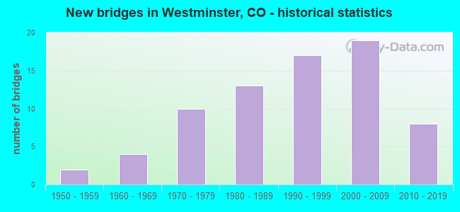
- New bridges - historical statistics
- 21950-1959
- 41960-1969
- 101970-1979
- 131980-1989
- 171990-1999
- 192000-2009
- 82010-2019

- Reconstructed bridges - Historical Statistics
- 11960-1969
- 01970-1979
- 21980-1989
- 21990-1999
- 22000-2009


- Bridge Condition - Deck
- 16.7%Very good
- 44.4%Good
- 38.9%Satisfactory

- Bridge Condition - Superstructure
- 19.4%Very good
- 38.9%Good
- 36.1%Satisfactory
- 5.6%Fair

- Bridge Condition - Substructure
- 16.7%Very good
- 44.4%Good
- 38.9%Satisfactory

- Bridge Condition - Channel
- 50.0%Very good
- 35.4%Good
- 14.6%Satisfactory

- Bridge Condition - Culverts
- 3.7%Very good
- 55.6%Good
- 40.7%Satisfactory
Find on map >> Show street view
Structure Number: 210269, Location: 0.2 mile east of SH 93 (Lat: 39.885556, Lng: -105.237778), Route carried "on" structure: Federal lands road , Year Built: 1952, Year Reconstructed: 1973, Status: Open, Structure Length: 1.44m (4.72ft), Average Daily Traffic: 200 (year 2012), Truck Traffic: 70%, Average Future Daily Traffic: 320 (year 2035), Design Load: HS 20, Features Intersected: S Boulder Diversion Cana, Facility Carried by Structure: West Gate Road
Minimum Vertical Clearance: 30+ m (98+ ft), Kilometerpoint: 0.000, Lanes on structure: 4, Owner: DOE, Approaching Roadway Width: 21.3m (69.9ft), Skew: 21 degrees, Material/Design: Steel, Design/Construction: Stringer/Multi-beam, Number Of Spans In Main Unit: 1, Length of Maximum Span: 12.9m (42.3ft), Curb or Sidewalk Widths: Left: 0.3m (1.0ft), Right: 0.3m (1.0ft), Curb-To-Curb Width: 17.6m (57.7ft), Out-to-Out Width: 20.1m (65.9ft)
Condition: Deck: Satisfactory, Superstructure: Satisfactory, Substructure: Satisfactory, Channel: Good, Operating Rating: 34.0 metric tons, Method Used To Determine Operating Rating: Load and Resistance Factor Rating (LRFR) rating reported by rating factor(RF) method using HL-93 loadings, Inventory Rating: 26.2 metric tons, Method Used To Determine Inventory Rating: Load and Resistance Factor Rating (LRFR) rating reported by rating factor(RF) method using HL-93 loadings, Structural Evaluation: Equal to present minimum criteria, Deck Geometry: Somewhat better than minimum adequacy, Waterway Adequacy: Equal to present desirable criteria, Approach Roadway Alignment: Equal to present desirable criteria, Designated Inspection Frequency: Every 24 months, Inspection Date: October 2020, Deck Structure Type: Concrete Cast-file-Place, Wearing Surface/Protective System: Wearing Surface: Bituminous, Membrane: Preformed Fabric
Find on map >> Show street view
Structure Number: E-16-GI, Location: 120TH AVE IN WESTMINSTER (Lat: 39.914111, Lng: -105.037081), Route carried "on" structure: US 287C, Year Built: 1965, Status: Open, Structure Length: 0.91m (2.99ft), Average Daily Traffic: 35,000 (year 2020), Truck Traffic: 4%, Average Future Daily Traffic: 39,200 (year 2040), Design Load: HS 20, Features Intersected: DITCH, Facility Carried by Structure: US 287 ML
Minimum Vertical Clearance: 30+ m (98+ ft), Kilometerpoint: 20.328, Lanes on structure: 6, Base Highway Network: Yes, Owner: State Highway Agency, Approaching Roadway Width: 23.2m (76.1ft), Skew: 4 degrees, Material/Design: Concrete, Design/Construction: Culvert, Number Of Spans In Main Unit: 2, Length of Maximum Span: 4.3m (14.1ft), Curb-To-Curb Width: 30.3m (99.4ft), Out-to-Out Width: 32.5m (106.6ft)
Condition: Channel: Satisfactory, Culverts: Satisfactory, Operating Rating: 36.3 metric tons, Method Used To Determine Operating Rating: Field evaluation and documented engineering judgment, Inventory Rating: 32.7 metric tons, Method Used To Determine Inventory Rating: Field evaluation and documented engineering judgment, Structural Evaluation: Equal to present minimum criteria, Deck Geometry: Superior to present desirable criteria, Waterway Adequacy: Equal to present minimum criteria, Approach Roadway Alignment: Equal to present desirable criteria, Designated Inspection Frequency: Every 24 months, Inspection Date: April 2021
Find on map >> Show street view
Structure Number: E-16-HN, Location: South of 92ND AVE. (Lat: 39.861953, Lng: -105.082531), Route carried "on" structure: State highway 121A, Year Built: 1968, Status: Open, Structure Length: 0.66m (2.17ft), Average Daily Traffic: 43,000 (year 2020), Truck Traffic: 1%, Average Future Daily Traffic: 50,310 (year 2040), Design Load: H 20, Features Intersected: HIGHLINE CANAL, Facility Carried by Structure: SH 121 ML
Minimum Vertical Clearance: 30+ m (98+ ft), Kilometerpoint: 34.763, Lanes on structure: 6, Base Highway Network: Yes, Owner: State Highway Agency, Approaching Roadway Width: 25.6m (84.0ft), Skew: 22 degrees, Material/Design: Concrete, Design/Construction: Culvert, Number Of Spans In Main Unit: 1, Length of Maximum Span: 6.6m (21.7ft), Out-to-Out Width: 44.3m (145.3ft)
Condition: Channel: Very good, Culverts: Satisfactory, Operating Rating: 36.3 metric tons, Method Used To Determine Operating Rating: Field evaluation and documented engineering judgment, Inventory Rating: 32.7 metric tons, Method Used To Determine Inventory Rating: Field evaluation and documented engineering judgment, Structural Evaluation: Equal to present minimum criteria, Waterway Adequacy: Equal to present desirable criteria, Approach Roadway Alignment: Equal to present desirable criteria, Designated Inspection Frequency: Every 24 months, Inspection Date: December 2020
Find on map >> Show street view
Structure Number: E-16-HU, Location: 200 FT N OF 76 AVE (Lat: 39.834914, Lng: -105.053122), Route carried "on" structure: State highway 95A, Year Built: 1971, Status: Open, Structure Length: 1.31m (4.30ft), Average Daily Traffic: 38,000 (year 2020), Truck Traffic: 4%, Average Future Daily Traffic: 41,040 (year 2040), Design Load: HS 20, Features Intersected: LITTLE DRY CREEK, Facility Carried by Structure: SH 95 ML
Minimum Vertical Clearance: 30.18m (99.02ft), Kilometerpoint: 20.352, Lanes on structure: 7, Base Highway Network: Yes, Owner: State Highway Agency, Approaching Roadway Width: 27.4m (89.9ft), Material/Design: Concrete, Design/Construction: Culvert, Number Of Spans In Main Unit: 4, Length of Maximum Span: 3.0m (9.8ft), Curb or Sidewalk Widths: Left: 1.7m (5.6ft), Right: 2.0m (6.6ft), Curb-To-Curb Width: 27.4m (89.9ft), Out-to-Out Width: 31.7m (104.0ft)
Condition: Channel: Very good, Culverts: Satisfactory, Operating Rating: 36.3 metric tons, Method Used To Determine Operating Rating: Field evaluation and documented engineering judgment, Inventory Rating: 32.7 metric tons, Method Used To Determine Inventory Rating: Field evaluation and documented engineering judgment, Structural Evaluation: Equal to present minimum criteria, Deck Geometry: Somewhat better than minimum adequacy, Waterway Adequacy: Equal to present desirable criteria, Approach Roadway Alignment: Equal to present desirable criteria, Designated Inspection Frequency: Every 24 months, Inspection Date: Febuary 2020
Find on map >> Show street view
Structure Number: E-16-IM, Location: IN WESTMINSTER (Lat: 39.851956, Lng: -105.052850), Route carried "on" structure: State highway 95A, Year Built: 1976, Status: Open, Structure Length: 4.91m (16.11ft), Average Daily Traffic: 31,000 (year 2020), Truck Traffic: 4%, Average Future Daily Traffic: 32,860 (year 2040), Design Load: HS 20+Mod, Features Intersected: RR SPUR, Facility Carried by Structure: SH 95 ML
Minimum Vertical Clearance: 30+ m (98+ ft), Kilometerpoint: 22.217, Lanes on structure: 4, Base Highway Network: Yes, Owner: State Highway Agency, Approaching Roadway Width: 16.5m (54.1ft), Skew: 23 degrees, Material/Design: Steel continuous, Design/Construction: Stringer/Multi-beam, Number Of Spans In Main Unit: 3, Length of Maximum Span: 19.5m (64.0ft), Curb or Sidewalk Widths: Left: 2.1m (6.9ft), Right: 2.1m (6.9ft), Curb-To-Curb Width: 17.1m (56.1ft), Out-to-Out Width: 22.1m (72.5ft)
Condition: Deck: Satisfactory, Superstructure: Satisfactory, Substructure: Satisfactory, Operating Rating: 51.7 metric tons, Method Used To Determine Operating Rating: Load Factor (LF), Inventory Rating: 31.0 metric tons, Method Used To Determine Inventory Rating: Load Factor (LF), Structural Evaluation: Equal to present minimum criteria, Deck Geometry: Somewhat better than minimum adequacy, Underclear: Better than present minimum criteria, Approach Roadway Alignment: Equal to present desirable criteria, Designated Inspection Frequency: Every 24 months, Inspection Date: Febuary 2020, Deck Structure Type: Concrete Cast-file-Place, Wearing Surface/Protective System: Wearing Surface: Bituminous, Membrane: Preformed Fabric
Find on map >> Show street view
Structure Number: E-16-KY, Location: BETWEEN 92ND & 104TH (Lat: 39.872281, Lng: -105.061453), Route carried "on" structure: City street , Year Built: 2001, Status: Open, Structure Length: 9.56m (31.36ft), Average Daily Traffic: 5,199 (year 2021), Truck Traffic: 10%, Average Future Daily Traffic: 5,979 (year 2041), Design Load: HS 20, Features Intersected: US 36 ML, Facility Carried by Structure: HARLAN/WEST.BLVD.
Minimum Vertical Clearance: 30+ m (98+ ft), Kilometerpoint: 0.429, Lanes on structure: 2, Lanes under structure: 6, Owner: State Highway Agency, Approaching Roadway Width: 19.8m (65.0ft), Skew: 2 degrees, Material/Design: Prestressed concrete continuous, Design/Construction: Stringer/Multi-beam, Number Of Spans In Main Unit: 2, Length of Maximum Span: 49.1m (161.1ft), Curb or Sidewalk Widths: Left: 0.0m, Right: 3.4m (11.2ft), Curb-To-Curb Width: 18.3m (60.0ft), Out-to-Out Width: 22.7m (74.5ft)
Condition: Deck: Good, Superstructure: Good, Substructure: Good, Operating Rating: 68.1 metric tons, Method Used To Determine Operating Rating: Load Factor (LF), Inventory Rating: 39.9 metric tons, Method Used To Determine Inventory Rating: Load Factor (LF), Structural Evaluation: Better than present minimum criteria, Deck Geometry: Superior to present desirable criteria, Underclear: Superior to present desirable criteria, Approach Roadway Alignment: Equal to present desirable criteria, Designated Inspection Frequency: Every 24 months, Inspection Date: August 2020, Deck Structure Type: Concrete Cast-file-Place, Wearing Surface/Protective System: Wearing Surface: Bituminous, Membrane: Built-up, Deck Protection: Epoxy Coated Reinforcing
Find on map >> Show street view
Structure Number: E-16-LA, Location: JUST W OF SHERIDAN BLVD (Lat: 39.863364, Lng: -105.056914), Route carried "on" structure: City street , Year Built: 1983, Status: Open, Structure Length: 7.79m (25.56ft), Average Daily Traffic: 23,806 (year 2021), Truck Traffic: 6%, Average Future Daily Traffic: 27,377 (year 2041), Design Load: HS 20+Mod, Features Intersected: US 36 ML, Facility Carried by Structure: 92ND AVENUE
Minimum Vertical Clearance: 30+ m (98+ ft), Kilometerpoint: 2.464, Lanes on structure: 9, Lanes under structure: 9, Owner: State Highway Agency, Approaching Roadway Width: 31.7m (104.0ft), Skew: 21 degrees, Material/Design: Prestressed concrete, Design/Construction: Stringer/Multi-beam, Number Of Spans In Main Unit: 2, Length of Maximum Span: 40.7m (133.5ft), Curb or Sidewalk Widths: Left: 2.4m (7.9ft), Right: 2.4m (7.9ft), Curb-To-Curb Width: 31.9m (104.7ft), Out-to-Out Width: 39.2m (128.6ft)
Condition: Deck: Satisfactory, Superstructure: Good, Substructure: Good, Operating Rating: 55.8 metric tons, Method Used To Determine Operating Rating: Load Factor (LF), Inventory Rating: 7.0 metric tons, Method Used To Determine Inventory Rating: Load Factor (LF), Structural Evaluation: High priority of corrective action, Deck Geometry: High priority of replacement, Underclear: Meets minimum limits, Approach Roadway Alignment: Equal to present desirable criteria, Length Of Structure Improvement: 7.80m (25.59ft), Designated Inspection Frequency: Every 24 months, Inspection Date: September 2020, Bridge Improvement Cost: $4,000, Total Project Cost: $5,000, Deck Structure Type: Concrete Cast-file-Place, Wearing Surface/Protective System: Wearing Surface: Bituminous, Membrane: Preformed Fabric, Deck Protection: Epoxy Coated Reinforcing
Find on map >> Show street view
Structure Number: E-16-LX, Location: 120th AVE., W. of FEDERAL (Lat: 39.914328, Lng: -105.027064), Route carried "on" structure: US 287C, Year Built: 1987, Status: Open, Structure Length: 4.59m (15.06ft), Average Daily Traffic: 41,000 (year 2020), Truck Traffic: 4%, Average Future Daily Traffic: 46,330 (year 2040), Design Load: HS 20+Mod, Features Intersected: BIG DRY CREEK, Facility Carried by Structure: US 287 ML
Minimum Vertical Clearance: 30+ m (98+ ft), Kilometerpoint: 19.488, Lanes on structure: 7, Base Highway Network: Yes, Owner: State Highway Agency, Approaching Roadway Width: 27.4m (89.9ft), Skew: 3 degrees, Material/Design: Concrete continuous, Design/Construction: Tee Beam, Number Of Spans In Main Unit: 3, Length of Maximum Span: 21.3m (69.9ft), Curb-To-Curb Width: 29.3m (96.1ft), Out-to-Out Width: 30.0m (98.4ft)
Condition: Deck: Good, Superstructure: Very good, Substructure: Very good, Channel: Very good, Inventory Rating: 69.9 metric tons, Method Used To Determine Inventory Rating: Load Factor (LF), Structural Evaluation: Equal to present desirable criteria, Deck Geometry: Somewhat better than minimum adequacy, Waterway Adequacy: Equal to present desirable criteria, Approach Roadway Alignment: Equal to present desirable criteria, Designated Inspection Frequency: Every 24 months, Inspection Date: March 2021, Deck Structure Type: Concrete Cast-file-Place, Wearing Surface/Protective System: Wearing Surface: Bituminous, Membrane: Preformed Fabric, Deck Protection: Epoxy Coated Reinforcing
Find on map >> Show street view
Structure Number: E-16-ND, Location: DENVER, OVER MOUSETRAP (Lat: 39.780094, Lng: -104.991922), Route carried "on" structure: Ramp Interstate 25A, Year Built: 1992, Status: Open, Structure Length: 58.90m (193.24ft), Average Daily Traffic: 125,500 (year 2020), Truck Traffic: 9%, Average Future Daily Traffic: 145,580 (year 2040), Design Load: HS 20+Mod, Features Intersected: I 25 ML, I 70 ML,RAMPS R, Facility Carried by Structure: RMP I70EB TO I25NB
Minimum Vertical Clearance: 30+ m (98+ ft), Kilometerpoint: 0.187, Lanes on structure: 1, Lanes under structure: 17, Base Highway Network: Yes, Owner: State Highway Agency, Approaching Roadway Width: 10.1m (33.1ft), Material/Design: Steel continuous, Design/Construction: Box Beam or Girders - Single/Spread, Number Of Spans In Main Unit: 11, Length of Maximum Span: 64.0m (210.0ft), Curb-To-Curb Width: 10.1m (33.1ft), Out-to-Out Width: 11.0m (36.1ft)
Condition: Deck: Satisfactory, Superstructure: Satisfactory, Substructure: Satisfactory, Operating Rating: 51.7 metric tons, Method Used To Determine Operating Rating: Load Factor (LF), Inventory Rating: 32.7 metric tons, Method Used To Determine Inventory Rating: Load Factor (LF), Structural Evaluation: Equal to present minimum criteria, Deck Geometry: Superior to present desirable criteria, Underclear: Meets minimum limits, Approach Roadway Alignment: Equal to present desirable criteria, Designated Inspection Frequency: Every 24 months, Critical Feature Inspection Frequency: Every 24 months, Inspection Date: September 2021, Critical Feature Inspection Date: September 2021, Deck Structure Type: Concrete Cast-file-Place, Wearing Surface/Protective System: Wearing Surface: Monolithic Concrete, Membrane: Preformed Fabric, Deck Protection: Epoxy Coated Reinforcing
Find on map >> Show street view
Structure Number: E-16-NI, Location: 3.95 MI N OF US 36 (Lat: 39.893808, Lng: -105.024883), Route carried "on" structure: US 287C, Year Built: 1999, Status: Open, Structure Length: 0.64m (2.10ft), Average Daily Traffic: 27,000 (year 2020), Truck Traffic: 2%, Average Future Daily Traffic: 32,940 (year 2040), Features Intersected: PEDESTRIAN UNDERPASS, Facility Carried by Structure: US 287 ML
Minimum Vertical Clearance: 30+ m (98+ ft), Kilometerpoint: 17.053, Lanes on structure: 4, Base Highway Network: Yes, Owner: State Highway Agency, Approaching Roadway Width: 28.0m (91.9ft), Material/Design: Concrete, Design/Construction: Culvert, Number Of Spans In Main Unit: 1, Length of Maximum Span: 6.4m (21.0ft), Curb or Sidewalk Widths: Left: 2.4m (7.9ft), Right: 2.4m (7.9ft)
Condition: Culverts: Very good, Operating Rating: 36.3 metric tons, Method Used To Determine Operating Rating: Field evaluation and documented engineering judgment, Inventory Rating: 32.7 metric tons, Method Used To Determine Inventory Rating: Field evaluation and documented engineering judgment, Structural Evaluation: Equal to present desirable criteria, Approach Roadway Alignment: Equal to present desirable criteria, Designated Inspection Frequency: Every 48 months, Inspection Date: Febuary 2019
Find on map >> Show street view
Structure Number: E-16-NM, Location: 2.4 MI SE BOULDER-JEFF CL (Lat: 39.886775, Lng: -105.071994), Route carried "on" structure: City street , Year Built: 1991, Status: Open, Structure Length: 6.46m (21.19ft), Average Daily Traffic: 27,449 (year 2020), Truck Traffic: 1%, Average Future Daily Traffic: 56,792 (year 2028), Design Load: HS 25 or greater, Features Intersected: US 36 ML, Facility Carried by Structure: 104TH AVE/CHURCH R
Minimum Vertical Clearance: 30+ m (98+ ft), Kilometerpoint: 2.607, Lanes on structure: 6, Lanes under structure: 6, Owner: State Highway Agency, Approaching Roadway Width: 22.6m (74.1ft), Material/Design: Prestressed concrete continuous, Design/Construction: Stringer/Multi-beam, Number Of Spans In Main Unit: 2, Length of Maximum Span: 31.9m (104.7ft), Curb or Sidewalk Widths: Left: 1.5m (4.9ft), Right: 1.5m (4.9ft), Curb-To-Curb Width: 22.6m (74.1ft), Out-to-Out Width: 28.0m (91.9ft)
Condition: Deck: Good, Superstructure: Good, Substructure: Satisfactory, Operating Rating: 67.7 metric tons, Method Used To Determine Operating Rating: Load Factor (LF), Inventory Rating: 40.6 metric tons, Method Used To Determine Inventory Rating: Load Factor (LF), Structural Evaluation: Equal to present minimum criteria, Deck Geometry: Meets minimum limits, Underclear: Better than present minimum criteria, Approach Roadway Alignment: Equal to present desirable criteria, Designated Inspection Frequency: Every 24 months, Inspection Date: August 2020, Deck Structure Type: Concrete Cast-file-Place, Wearing Surface/Protective System: Wearing Surface: Bituminous, Deck Protection: Epoxy Coated Reinforcing
Find on map >> Show street view
Structure Number: E-16-P, Location: Sheridan 1.0 MI N of I 70 (Lat: 39.798250, Lng: -105.053178), Route carried "on" structure: State highway 95A, Year Built: 1953, Year Reconstructed: 1985, Status: Open, Structure Length: 6.20m (20.34ft), Average Daily Traffic: 37,000 (year 2020), Truck Traffic: 3%, Average Future Daily Traffic: 37,740 (year 2040), Design Load: HS 20, Features Intersected: CLEAR CREEK, Facility Carried by Structure: SH 95 ML
Minimum Vertical Clearance: 30+ m (98+ ft), Kilometerpoint: 16.222, Lanes on structure: 7, Base Highway Network: Yes, Owner: State Highway Agency, Approaching Roadway Width: 35.4m (116.1ft), Material/Design: Steel continuous, Design/Construction: Stringer/Multi-beam, Number Of Spans In Main Unit: 3, Length of Maximum Span: 23.2m (76.1ft), Curb or Sidewalk Widths: Left: 2.5m (8.2ft), Right: 2.5m (8.2ft), Curb-To-Curb Width: 35.4m (116.1ft), Out-to-Out Width: 41.3m (135.5ft)
Condition: Deck: Satisfactory, Superstructure: Satisfactory, Substructure: Satisfactory, Channel: Good, Operating Rating: 54.3 metric tons, Method Used To Determine Operating Rating: Load Factor (LF), Inventory Rating: 32.6 metric tons, Method Used To Determine Inventory Rating: Load Factor (LF), Structural Evaluation: Equal to present minimum criteria, Deck Geometry: Superior to present desirable criteria, Waterway Adequacy: Equal to present desirable criteria, Approach Roadway Alignment: Equal to present desirable criteria, Designated Inspection Frequency: Every 24 months, Inspection Date: Febuary 2020, Deck Structure Type: Concrete Cast-file-Place, Wearing Surface/Protective System: Wearing Surface: Bituminous, Membrane: Preformed Fabric, Deck Protection: Epoxy Coated Reinforcing
Find on map >> Show street view
Structure Number: E-16-PX, Location: FEDERAL @ US 36 IN WEST. (Lat: 39.835633, Lng: -105.024708), Route carried "on" structure: US 287C, Year Built: 2002, Status: Open, Structure Length: 10.52m (34.51ft), Average Daily Traffic: 40,000 (year 2020), Truck Traffic: 3%, Average Future Daily Traffic: 45,200 (year 2040), Design Load: HS 20+Mod, Features Intersected: US 36 ML, Facility Carried by Structure: US 287 ML
Minimum Vertical Clearance: 30+ m (98+ ft), Kilometerpoint: 10.589, Lanes on structure: 6, Lanes under structure: 9, Base Highway Network: Yes, Owner: State Highway Agency, Approaching Roadway Width: 31.1m (102.0ft), Skew: 32 degrees, Material/Design: Prestressed concrete continuous, Design/Construction: Stringer/Multi-beam, Number Of Spans In Main Unit: 2, Length of Maximum Span: 52.0m (170.6ft), Curb or Sidewalk Widths: Left: 0.0m, Right: 2.9m (9.5ft), Curb-To-Curb Width: 31.1m (102.0ft), Out-to-Out Width: 34.9m (114.5ft)
Condition: Deck: Very good, Superstructure: Good, Substructure: Very good, Operating Rating: 84.5 metric tons, Method Used To Determine Operating Rating: Load Factor (LF), Inventory Rating: 50.5 metric tons, Method Used To Determine Inventory Rating: Load Factor (LF), Structural Evaluation: Better than present minimum criteria, Deck Geometry: Superior to present desirable criteria, Underclear: Meets minimum limits, Approach Roadway Alignment: Equal to present desirable criteria, Designated Inspection Frequency: Every 24 months, Inspection Date: April 2021, Deck Structure Type: Concrete Precast Panels, Wearing Surface/Protective System: Wearing Surface: Bituminous, Membrane: Built-up, Deck Protection: Epoxy Coated Reinforcing
Find on map >> Show street view
Structure Number: E-16-WC, Location: 500 ft N of 76th Ave (Lat: 39.835311, Lng: -105.053072), Route carried "on" structure: State highway 95A, Year Built: 2001, Status: Open, Structure Length: 0.67m (2.20ft), Average Daily Traffic: 38,000 (year 2020), Truck Traffic: 4%, Average Future Daily Traffic: 41,040 (year 2040), Design Load: HS 20, Features Intersected: LITTLE DRY CREEK TRAIL, Facility Carried by Structure: SH 95 ML
Minimum Vertical Clearance: 18.17m (59.61ft), Kilometerpoint: 20.397, Lanes on structure: 7, Base Highway Network: Yes, Owner: State Highway Agency, Approaching Roadway Width: 27.4m (89.9ft), Material/Design: Concrete, Design/Construction: Culvert, Number Of Spans In Main Unit: 1, Length of Maximum Span: 6.7m (22.0ft), Curb or Sidewalk Widths: Left: 3.4m (11.2ft), Right: 2.8m (9.2ft), Curb-To-Curb Width: 27.5m (90.2ft), Out-to-Out Width: 35.2m (115.5ft)
Condition: Culverts: Good, Operating Rating: 36.3 metric tons, Method Used To Determine Operating Rating: Field evaluation and documented engineering judgment, Inventory Rating: 32.7 metric tons, Method Used To Determine Inventory Rating: Field evaluation and documented engineering judgment, Structural Evaluation: Better than present minimum criteria, Deck Geometry: Somewhat better than minimum adequacy, Approach Roadway Alignment: Equal to present desirable criteria, Designated Inspection Frequency: Every 24 months, Inspection Date: Febuary 2020
Find on map >> Show street view
Structure Number: E-16-WW, Location: 0.2 MI NW CHURCH RANCH RD (Lat: 39.889750, Lng: -105.073411), Route carried "on" structure: US 36B, Year Built: 2006, Status: Open, Structure Length: 1.83m (6.00ft), Average Daily Traffic: 74,000 (year 2020), Truck Traffic: 3%, Average Future Daily Traffic: 86,580 (year 2040), Design Load: HL 93, Features Intersected: Promenade Dr., Facility Carried by Structure: US 36 ML
Minimum Vertical Clearance: 30+ m (98+ ft), Kilometerpoint: 80.918, Lanes on structure: 8, Lanes under structure: 4, Base Highway Network: Yes, Owner: State Highway Agency, Maintenance Responsibility: City or Municipal Highway Agency, Approaching Roadway Width: 48.2m (158.1ft), Skew: 31 degrees, Material/Design: Prestressed concrete, Design/Construction: Stringer/Multi-beam, Number Of Spans In Main Unit: 1, Length of Maximum Span: 17.4m (57.1ft), Curb or Sidewalk Widths: Left: 0.0m, Right: 3.7m (12.1ft), Curb-To-Curb Width: 48.2m (158.1ft), Out-to-Out Width: 50.3m (165.0ft)
Condition: Deck: Satisfactory, Superstructure: Satisfactory, Substructure: Satisfactory, Operating Rating: 42.1 metric tons, Method Used To Determine Operating Rating: Load and Resistance Factor Rating (LRFR) rating reported by rating factor(RF) method using HL-93 loadings, Inventory Rating: 32.4 metric tons, Method Used To Determine Inventory Rating: Load and Resistance Factor Rating (LRFR) rating reported by rating factor(RF) method using HL-93 loadings, Structural Evaluation: Equal to present minimum criteria, Deck Geometry: Superior to present desirable criteria, Underclear: Better than present minimum criteria, Approach Roadway Alignment: Equal to present desirable criteria, Designated Inspection Frequency: Every 24 months, Inspection Date: August 2020, Deck Structure Type: Concrete Precast Panels, Wearing Surface/Protective System: Wearing Surface: Bituminous, Membrane: Built-up, Deck Protection: Epoxy Coated Reinforcing
Find on map >> Show street view
Structure Number: E-16-YC, Location: 1.5 MI S of SH128 (Lat: 39.901467, Lng: -105.081917), Route carried "on" structure: County highway , Year Built: 2014, Status: Open, Structure Length: 6.47m (21.23ft), Average Daily Traffic: 73,652 (year 2020), Truck Traffic: 3%, Average Future Daily Traffic: 17,686 (year 2028), Design Load: HL 93, Features Intersected: US 36 ML, Facility Carried by Structure: CNTY RD / OLD WADS
Minimum Vertical Clearance: 30+ m (98+ ft), Kilometerpoint: 1.745, Lanes on structure: 3, Lanes under structure: 4, Owner: State Highway Agency, Approaching Roadway Width: 12.8m (42.0ft), Skew: 2 degrees, Material/Design: Prestressed concrete continuous, Design/Construction: Stringer/Multi-beam, Number Of Spans In Main Unit: 2, Length of Maximum Span: 34.7m (113.8ft), Curb or Sidewalk Widths: Left: 2.6m (8.5ft), Right: 2.5m (8.2ft), Curb-To-Curb Width: 22.9m (75.1ft), Out-to-Out Width: 29.0m (95.1ft)
Condition: Deck: Good, Superstructure: Good, Substructure: Good, Operating Rating: 69.7 metric tons, Method Used To Determine Operating Rating: Load and Resistance Factor Rating (LRFR) rating reported by rating factor(RF) method using HL-93 loadings, Inventory Rating: 44.1 metric tons, Method Used To Determine Inventory Rating: Load and Resistance Factor Rating (LRFR) rating reported by rating factor(RF) method using HL-93 loadings, Structural Evaluation: Better than present minimum criteria, Deck Geometry: Superior to present desirable criteria, Underclear: Superior to present desirable criteria, Approach Roadway Alignment: Better than present minimum criteria, Length Of Structure Improvement: 5.55m (18.21ft), Designated Inspection Frequency: Every 24 months, Inspection Date: September 2020, Bridge Improvement Cost: $223,000, Roadway Improvement Cost: $22,000, Total Project Cost: $334,000, Deck Structure Type: Concrete Cast-file-Place, Wearing Surface/Protective System: Wearing Surface: Bituminous, Membrane: Built-up, Deck Protection: Epoxy Coated Reinforcing
Find on map >> Show street view
Structure Number: E-16-YF, Location: IN WESTMINSTER (Lat: 39.842067, Lng: -105.039822), Route carried "on" structure: City street , Year Built: 2010, Status: Open, Structure Length: 6.74m (22.11ft), Average Daily Traffic: 15,264 (year 2021), Truck Traffic: 1%, Average Future Daily Traffic: 19,844 (year 2041), Features Intersected: US 36 ML, Facility Carried by Structure: 80TH AVE
Minimum Vertical Clearance: 30+ m (98+ ft), Kilometerpoint: 1.165, Lanes on structure: 4, Lanes under structure: 6, Owner: State Highway Agency, Approaching Roadway Width: 20.7m (67.9ft), Skew: 4 degrees, Material/Design: Prestressed concrete continuous, Design/Construction: Box Beam or Girders - Multiple, Number Of Spans In Main Unit: 2, Length of Maximum Span: 33.2m (108.9ft), Curb or Sidewalk Widths: Left: 2.6m (8.5ft), Right: 2.6m (8.5ft), Curb-To-Curb Width: 20.7m (67.9ft), Out-to-Out Width: 27.4m (89.9ft)
Condition: Deck: Good, Superstructure: Good, Substructure: Good, Operating Rating: 81.6 metric tons, Method Used To Determine Operating Rating: Load Factor (LF), Inventory Rating: 58.6 metric tons, Method Used To Determine Inventory Rating: Load Factor (LF), Structural Evaluation: Better than present minimum criteria, Deck Geometry: Superior to present desirable criteria, Underclear: Better than present minimum criteria, Approach Roadway Alignment: Equal to present desirable criteria, Length Of Structure Improvement: 5.80m (19.03ft), Designated Inspection Frequency: Every 24 months, Inspection Date: September 2020, Deck Structure Type: Concrete Cast-file-Place, Wearing Surface/Protective System: Wearing Surface: Bituminous, Membrane: Built-up
Find on map >> Show street view
Structure Number: E-16-ZB, Location: IN WESTMINSTER (Lat: 39.859431, Lng: -105.055072), Route carried "on" structure: State highway 95A, Year Built: 2014, Status: Open, Structure Length: 6.50m (21.33ft), Average Daily Traffic: 44,000 (year 2020), Truck Traffic: 3%, Average Future Daily Traffic: 46,200 (year 2040), Design Load: HL 93, Features Intersected: US 36 ML, Facility Carried by Structure: SH 95 ML(SHERIDAN)
Minimum Vertical Clearance: 30+ m (98+ ft), Kilometerpoint: 23.149, Lanes on structure: 9, Lanes under structure: 6, Base Highway Network: Yes, Owner: State Highway Agency, Approaching Roadway Width: 45.7m (149.9ft), Skew: 23 degrees, Material/Design: Prestressed concrete continuous, Design/Construction: Stringer/Multi-beam, Number Of Spans In Main Unit: 2, Length of Maximum Span: 35.6m (116.8ft), Curb or Sidewalk Widths: Left: 2.6m (8.5ft), Right: 2.6m (8.5ft), Curb-To-Curb Width: 39.0m (128.0ft), Out-to-Out Width: 45.7m (149.9ft)
Condition: Deck: Very good, Superstructure: Good, Substructure: Very good, Operating Rating: 61.6 metric tons, Method Used To Determine Operating Rating: Load and Resistance Factor Rating (LRFR) rating reported by rating factor(RF) method using HL-93 loadings, Inventory Rating: 48.6 metric tons, Method Used To Determine Inventory Rating: Load and Resistance Factor Rating (LRFR) rating reported by rating factor(RF) method using HL-93 loadings, Structural Evaluation: Better than present minimum criteria, Deck Geometry: Superior to present desirable criteria, Underclear: Equal to present minimum criteria, Approach Roadway Alignment: Equal to present desirable criteria, Designated Inspection Frequency: Every 24 months, Inspection Date: Febuary 2020, Deck Structure Type: Concrete Cast-file-Place, Wearing Surface/Protective System: Wearing Surface: Bituminous, Membrane: Built-up, Deck Protection: Epoxy Coated Reinforcing
Find on map >> Show street view
Structure Number: WST01-12-M, Location: .5 MI E OF WADSWORTH BLVD (Lat: 39.863694, Lng: -105.077333), Route carried "on" structure: City street , Year Built: 1985, Status: Open, Structure Length: 7.71m (25.30ft), Average Daily Traffic: 10,995 (year 2021), Truck Traffic: 5%, Average Future Daily Traffic: 12,644 (year 2041), Design Load: HS 20, Features Intersected: RAILROAD, Facility Carried by Structure: 92ND AVENUE
Minimum Vertical Clearance: 30+ m (98+ ft), Kilometerpoint: 0.660, Lanes on structure: 4, Base Highway Network: Yes, Owner: City or Municipal Highway Agency, Approaching Roadway Width: 15.8m (51.8ft), Skew: 35 degrees, Material/Design: Prestressed concrete, Design/Construction: Stringer/Multi-beam, Number Of Spans In Main Unit: 3, Length of Maximum Span: 29.6m (97.1ft), Curb or Sidewalk Widths: Left: 2.4m (7.9ft), Right: 2.4m (7.9ft), Curb-To-Curb Width: 15.8m (51.8ft), Out-to-Out Width: 27.8m (91.2ft)
Condition: Deck: Satisfactory, Superstructure: Satisfactory, Substructure: Satisfactory, Operating Rating: 53.8 metric tons, Method Used To Determine Operating Rating: Load Factor (LF), Inventory Rating: 29.4 metric tons, Method Used To Determine Inventory Rating: Load Factor (LF), Structural Evaluation: Equal to present minimum criteria, Deck Geometry: Meets minimum limits, Underclear: Superior to present desirable criteria, Approach Roadway Alignment: Equal to present desirable criteria, Designated Inspection Frequency: Every 24 months, Inspection Date: March 2021, Deck Structure Type: Concrete Cast-file-Place, Wearing Surface/Protective System: Wearing Surface: Bituminous, Membrane: Built-up
Find on map >> Show street view
Structure Number: WST02-10-F, Location: 112TH AVE AT HARLAN ST (Lat: 39.899806, Lng: -105.062031), Route carried "on" structure: City street , Year Built: 1979, Status: Open, Structure Length: 0.69m (2.26ft), Average Daily Traffic: 11,867 (year 2021), Truck Traffic: 6%, Average Future Daily Traffic: 13,647 (year 2041), Design Load: HS 20, Features Intersected: BIG BULL CREEK, Facility Carried by Structure: 112TH AVENUE
Minimum Vertical Clearance: 30+ m (98+ ft), Kilometerpoint: 1.048, Lanes on structure: 5, Owner: City or Municipal Highway Agency, Approaching Roadway Width: 20.7m (67.9ft), Material/Design: Concrete, Design/Construction: Culvert, Number Of Spans In Main Unit: 3, Length of Maximum Span: 1.8m (5.9ft), Curb or Sidewalk Widths: Left: 1.2m (3.9ft), Right: 1.2m (3.9ft), Curb-To-Curb Width: 34.1m (111.9ft), Out-to-Out Width: 34.8m (114.2ft)
Condition: Channel: Good, Culverts: Satisfactory, Operating Rating: 36.3 metric tons, Method Used To Determine Operating Rating: Field evaluation and documented engineering judgment, Inventory Rating: 32.7 metric tons, Method Used To Determine Inventory Rating: Field evaluation and documented engineering judgment, Structural Evaluation: Equal to present minimum criteria, Deck Geometry: Superior to present desirable criteria, Waterway Adequacy: Better than present minimum criteria, Approach Roadway Alignment: Equal to present desirable criteria, Designated Inspection Frequency: Every 48 months, Inspection Date: Febuary 2019
Find on map >> Show street view
Structure Number: WST02-11-M, Location: 3 BLOCKS W OF PIERCE/92ND (Lat: 39.863611, Lng: -105.073919), Route carried "on" structure: City street , Year Built: 1985, Status: Open, Structure Length: 0.69m (2.26ft), Average Daily Traffic: 10,995 (year 2021), Truck Traffic: 6%, Average Future Daily Traffic: 12,644 (year 2041), Design Load: HS 20, Features Intersected: FARMERS HIGHLINE CANAL, Facility Carried by Structure: 92ND AVENUE
Minimum Vertical Clearance: 30+ m (98+ ft), Kilometerpoint: 0.980, Lanes on structure: 4, Base Highway Network: Yes, Owner: City or Municipal Highway Agency, Approaching Roadway Width: 16.4m (53.8ft), Skew: 24 degrees, Material/Design: Concrete, Design/Construction: Culvert, Number Of Spans In Main Unit: 1, Length of Maximum Span: 6.9m (22.6ft), Curb or Sidewalk Widths: Left: 2.4m (7.9ft), Right: 2.4m (7.9ft), Out-to-Out Width: 43.6m (143.0ft)
Condition: Channel: Satisfactory, Culverts: Satisfactory, Inventory Rating: 54.3 metric tons, Method Used To Determine Inventory Rating: Load Factor (LF), Structural Evaluation: Equal to present minimum criteria, Waterway Adequacy: Equal to present desirable criteria, Approach Roadway Alignment: Equal to present desirable criteria, Designated Inspection Frequency: Every 24 months, Inspection Date: Febuary 2021
Find on map >> Show street view
Structure Number: WST03-10-M, Location: JUST N OF 92 AVENUE (Lat: 39.864003, Lng: -105.072617), Route carried "on" structure: City street , Year Built: 1995, Status: Open, Structure Length: 0.79m (2.59ft), Average Daily Traffic: 609 (year 2021), Average Future Daily Traffic: 700 (year 2041), Design Load: HS 20, Features Intersected: FARMERS HIGHLINE CANAL, Facility Carried by Structure: 92ND LANE
Minimum Vertical Clearance: 30+ m (98+ ft), Kilometerpoint: 0.032, Lanes on structure: 3, Owner: City or Municipal Highway Agency, Approaching Roadway Width: 10.7m (35.1ft), Material/Design: Concrete, Design/Construction: Frame, Number Of Spans In Main Unit: 1, Length of Maximum Span: 7.3m (24.0ft), Curb or Sidewalk Widths: Left: 1.4m (4.6ft), Right: 1.4m (4.6ft), Curb-To-Curb Width: 10.8m (35.4ft), Out-to-Out Width: 16.8m (55.1ft)
Condition: Deck: Good, Superstructure: Good, Substructure: Good, Channel: Very good, Operating Rating: 37.5 metric tons, Method Used To Determine Operating Rating: Load Factor (LF), Inventory Rating: 22.5 metric tons, Method Used To Determine Inventory Rating: Load Factor (LF), Structural Evaluation: Equal to present minimum criteria, Deck Geometry: High priority of replacement, Waterway Adequacy: Equal to present desirable criteria, Approach Roadway Alignment: Equal to present desirable criteria, Length Of Structure Improvement: 0.79m (2.59ft), Designated Inspection Frequency: Every 24 months, Inspection Date: March 2021, Bridge Improvement Cost: $138,000, Roadway Improvement Cost: $14,000, Total Project Cost: $151,000 ( Estimate for 2015), Deck Structure Type: Other, Wearing Surface/Protective System: Wearing Surface: Bituminous
Find on map >> Show street view
Structure Number: WST03-18-F, Location: 0.1 MI N OF 108TH AVE (Lat: 39.893900, Lng: -105.111053), Route carried "on" structure: City street , Year Built: 1999, Status: Open, Structure Length: 0.99m (3.25ft), Average Daily Traffic: 3,630 (year 2021), Average Future Daily Traffic: 4,175 (year 2041), Design Load: HS 20, Features Intersected: WALNUT CREEK, Facility Carried by Structure: WESTMOOR DR
Minimum Vertical Clearance: 30.45m (99.90ft), Kilometerpoint: 0.127, Lanes on structure: 2, Owner: City or Municipal Highway Agency, Approaching Roadway Width: 15.6m (51.2ft), Material/Design: Concrete, Design/Construction: Culvert, Number Of Spans In Main Unit: 2, Length of Maximum Span: 4.7m (15.4ft), Curb or Sidewalk Widths: Left: 3.7m (12.1ft), Right: 2.1m (6.9ft), Curb-To-Curb Width: 18.3m (60.0ft), Out-to-Out Width: 24.6m (80.7ft)
Condition: Channel: Very good, Culverts: Good, Operating Rating: 51.6 metric tons, Method Used To Determine Operating Rating: Load Factor (LF), Inventory Rating: 39.8 metric tons, Method Used To Determine Inventory Rating: Load Factor (LF), Structural Evaluation: Better than present minimum criteria, Deck Geometry: Superior to present desirable criteria, Waterway Adequacy: Equal to present desirable criteria, Approach Roadway Alignment: Equal to present desirable criteria, Designated Inspection Frequency: Every 24 months, Inspection Date: March 2021
Find on map >> Show street view
Structure Number: WST04-09-G, Location: S OF 110TH AVENUE (Lat: 39.896525, Lng: -105.059142), Route carried "on" structure: City street , Year Built: 1975, Status: Open, Structure Length: 0.71m (2.33ft), Average Daily Traffic: 2,331 (year 2021), Truck Traffic: 2%, Average Future Daily Traffic: 2,680 (year 2041), Design Load: HS 20, Features Intersected: BIG BULL CREEK, Facility Carried by Structure: EATON STREET
Minimum Vertical Clearance: 30+ m (98+ ft), Kilometerpoint: 0.466, Lanes on structure: 2, Owner: City or Municipal Highway Agency, Approaching Roadway Width: 13.1m (43.0ft), Skew: 21 degrees, Material/Design: Concrete, Design/Construction: Culvert, Number Of Spans In Main Unit: 3, Length of Maximum Span: 1.9m (6.2ft), Curb or Sidewalk Widths: Left: 1.4m (4.6ft), Right: 2.7m (8.9ft), Out-to-Out Width: 32.2m (105.6ft)
Condition: Channel: Good, Culverts: Good, Operating Rating: 36.3 metric tons, Method Used To Determine Operating Rating: Field evaluation and documented engineering judgment, Inventory Rating: 32.7 metric tons, Method Used To Determine Inventory Rating: Field evaluation and documented engineering judgment, Structural Evaluation: Better than present minimum criteria, Waterway Adequacy: Better than present minimum criteria, Approach Roadway Alignment: Equal to present desirable criteria, Designated Inspection Frequency: Every 48 months, Inspection Date: Febuary 2019
Find on map >> Show street view
Structure Number: WST05-09-GA, Location: 0.2 MI S OF 112TH AVENUE (Lat: 39.896836, Lng: -105.053033), Route carried "on" structure: City street , Year Built: 1995, Status: Open, Structure Length: 3.86m (12.66ft), Average Daily Traffic: 28,771 (year 2021), Truck Traffic: 5%, Average Future Daily Traffic: 33,087 (year 2041), Design Load: HS 20, Features Intersected: BIG DRY CREEK, Facility Carried by Structure: SHERIDAN BLVD
Minimum Vertical Clearance: 30+ m (98+ ft), Kilometerpoint: 4.098, Lanes on structure: 4, Base Highway Network: Yes, Owner: City or Municipal Highway Agency, Approaching Roadway Width: 16.5m (54.1ft), Skew: 33 degrees, Material/Design: Prestressed concrete, Design/Construction: Stringer/Multi-beam, Number Of Spans In Main Unit: 1, Length of Maximum Span: 36.7m (120.4ft), Curb or Sidewalk Widths: Left: 2.7m (8.9ft), Right: 1.5m (4.9ft), Curb-To-Curb Width: 20.1m (65.9ft), Out-to-Out Width: 29.1m (95.5ft)
Condition: Deck: Good, Superstructure: Very good, Substructure: Good, Channel: Very good, Operating Rating: 49.0 metric tons, Method Used To Determine Operating Rating: Load Factor (LF), Inventory Rating: 29.4 metric tons, Method Used To Determine Inventory Rating: Load Factor (LF), Structural Evaluation: Better than present minimum criteria, Deck Geometry: Better than present minimum criteria, Waterway Adequacy: Equal to present desirable criteria, Approach Roadway Alignment: Equal to present desirable criteria, Designated Inspection Frequency: Every 24 months, Inspection Date: March 2021, Deck Structure Type: Concrete Cast-file-Place, Wearing Surface/Protective System: Wearing Surface: Bituminous, Membrane: Built-up, Deck Protection: Epoxy Coated Reinforcing
Find on map >> Show street view
Structure Number: WST06-09-K, Location: JUST NORTH OF 98TH AVENUE (Lat: 39.875061, Lng: -105.053183), Route carried "on" structure: City street , Year Built: 1983, Status: Open, Structure Length: 0.69m (2.26ft), Average Daily Traffic: 17,390 (year 2021), Truck Traffic: 5%, Average Future Daily Traffic: 19,999 (year 2041), Features Intersected: BIG DRY CREEK TRIBUTARY, Facility Carried by Structure: SHERIDAN BLVD
Minimum Vertical Clearance: 30+ m (98+ ft), Kilometerpoint: 1.678, Lanes on structure: 5, Base Highway Network: Yes, Owner: City or Municipal Highway Agency, Approaching Roadway Width: 23.2m (76.1ft), Skew: 33 degrees, Material/Design: Concrete, Design/Construction: Culvert, Number Of Spans In Main Unit: 2, Length of Maximum Span: 3.3m (10.8ft), Curb or Sidewalk Widths: Left: 2.4m (7.9ft), Right: 2.0m (6.6ft), Curb-To-Curb Width: 20.0m (65.6ft), Out-to-Out Width: 30.1m (98.8ft)
Condition: Channel: Satisfactory, Culverts: Satisfactory, Operating Rating: 36.3 metric tons, Method Used To Determine Operating Rating: Field evaluation and documented engineering judgment, Inventory Rating: 32.7 metric tons, Method Used To Determine Inventory Rating: Field evaluation and documented engineering judgment, Structural Evaluation: Equal to present minimum criteria, Deck Geometry: Somewhat better than minimum adequacy, Waterway Adequacy: Equal to present desirable criteria, Approach Roadway Alignment: Equal to present desirable criteria, Designated Inspection Frequency: Every 24 months, Inspection Date: March 2021
Find on map >> Show street view
Structure Number: WST06-12-M, Location: S. OF 91ST AVENUE (Lat: 39.861244, Lng: -105.085897), Route carried "on" structure: City street , Year Built: 1975, Status: Open, Structure Length: 1.40m (4.59ft), Average Daily Traffic: 2,735 (year 2021), Truck Traffic: 2%, Average Future Daily Traffic: 3,145 (year 2041), Features Intersected: FARMERS HIGHLINE CANAL, Facility Carried by Structure: YARROW STREET
Minimum Vertical Clearance: 30+ m (98+ ft), Kilometerpoint: 0.149, Lanes on structure: 2, Owner: City or Municipal Highway Agency, Approaching Roadway Width: 11.0m (36.1ft), Material/Design: Prestressed concrete, Design/Construction: Tee Beam, Number Of Spans In Main Unit: 1, Length of Maximum Span: 12.8m (42.0ft), Curb or Sidewalk Widths: Left: 1.4m (4.6ft), Right: 1.4m (4.6ft), Curb-To-Curb Width: 11.0m (36.1ft), Out-to-Out Width: 13.7m (44.9ft)
Condition: Deck: Satisfactory, Superstructure: Satisfactory, Substructure: Satisfactory, Channel: Good, Operating Rating: 36.3 metric tons, Method Used To Determine Operating Rating: Field evaluation and documented engineering judgment, Inventory Rating: 32.7 metric tons, Method Used To Determine Inventory Rating: Field evaluation and documented engineering judgment, Structural Evaluation: Equal to present minimum criteria, Deck Geometry: Somewhat better than minimum adequacy, Waterway Adequacy: Equal to present desirable criteria, Approach Roadway Alignment: Equal to present desirable criteria, Designated Inspection Frequency: Every 24 months, Inspection Date: March 2021, Deck Structure Type: Concrete Cast-file-Place, Wearing Surface/Protective System: Wearing Surface: Bituminous
Find on map >> Show street view
Structure Number: WST07-13-M, Location: JUST SOUTH OF 89TH COURT (Lat: 39.859444, Lng: -105.098694), Route carried "on" structure: City street , Year Built: 1979, Status: Open, Structure Length: 1.49m (4.89ft), Average Daily Traffic: 1,815 (year 2021), Truck Traffic: 2%, Average Future Daily Traffic: 2,087 (year 2041), Features Intersected: FARMERS HIGHLINE CANAL, Facility Carried by Structure: FIELD STREET
Minimum Vertical Clearance: 30+ m (98+ ft), Kilometerpoint: 0.359, Lanes on structure: 2, Owner: City or Municipal Highway Agency, Approaching Roadway Width: 11.3m (37.1ft), Material/Design: Prestressed concrete, Design/Construction: Tee Beam, Number Of Spans In Main Unit: 1, Length of Maximum Span: 14.3m (46.9ft), Curb or Sidewalk Widths: Left: 1.4m (4.6ft), Right: 1.4m (4.6ft), Curb-To-Curb Width: 11.3m (37.1ft), Out-to-Out Width: 14.0m (45.9ft)
Condition: Deck: Satisfactory, Superstructure: Fair, Substructure: Satisfactory, Channel: Good, Operating Rating: 36.3 metric tons, Method Used To Determine Operating Rating: Field evaluation and documented engineering judgment, Inventory Rating: 32.7 metric tons, Method Used To Determine Inventory Rating: Field evaluation and documented engineering judgment, Structural Evaluation: Somewhat better than minimum adequacy, Deck Geometry: Equal to present minimum criteria, Waterway Adequacy: Equal to present desirable criteria, Approach Roadway Alignment: Better than present minimum criteria, Designated Inspection Frequency: Every 24 months, Inspection Date: March 2021, Deck Structure Type: Concrete Cast-file-Place, Wearing Surface/Protective System: Wearing Surface: Bituminous
Find on map >> Show street view
Structure Number: WST08-14-M, Location: S OF INDEPENDENCE CIRCLE (Lat: 39.859417, Lng: -105.103583), Route carried "on" structure: City street , Year Built: 1975, Status: Open, Structure Length: 1.51m (4.95ft), Average Daily Traffic: 4,585 (year 2021), Truck Traffic: 2%, Average Future Daily Traffic: 5,273 (year 2041), Features Intersected: FARMERS HIGHLINE CANAL, Facility Carried by Structure: INDEPENDENCE DRIVE
Minimum Vertical Clearance: 30.45m (99.90ft), Kilometerpoint: 0.345, Lanes on structure: 2, Owner: City or Municipal Highway Agency, Approaching Roadway Width: 13.4m (44.0ft), Material/Design: Prestressed concrete, Design/Construction: Tee Beam, Number Of Spans In Main Unit: 1, Length of Maximum Span: 14.2m (46.6ft), Curb or Sidewalk Widths: Left: 0.3m (1.0ft), Right: 0.3m (1.0ft), Curb-To-Curb Width: 13.5m (44.3ft), Out-to-Out Width: 14.7m (48.2ft)
Condition: Deck: Satisfactory, Superstructure: Fair, Substructure: Satisfactory, Channel: Good, Operating Rating: 36.3 metric tons, Method Used To Determine Operating Rating: Field evaluation and documented engineering judgment, Inventory Rating: 32.7 metric tons, Method Used To Determine Inventory Rating: Field evaluation and documented engineering judgment, Structural Evaluation: Somewhat better than minimum adequacy, Deck Geometry: Superior to present desirable criteria, Waterway Adequacy: Equal to present desirable criteria, Approach Roadway Alignment: Equal to present minimum criteria, Designated Inspection Frequency: Every 24 months, Inspection Date: March 2021, Deck Structure Type: Concrete Cast-file-Place, Wearing Surface/Protective System: Wearing Surface: Bituminous
Find on map >> Show street view
Structure Number: WST08-8-R, Location: N OF 72ND ON TENNYSON ST (Lat: 39.828844, Lng: -105.044328), Route carried "on" structure: City street , Year Built: 1988, Status: Open, Structure Length: 1.63m (5.35ft), Average Daily Traffic: 1,652 (year 2021), Truck Traffic: 2%, Average Future Daily Traffic: 2,148 (year 2041), Design Load: HS 20, Features Intersected: LITTLE DRY CREEK, Facility Carried by Structure: TENNYSON ST
Minimum Vertical Clearance: 30+ m (98+ ft), Kilometerpoint: 0.172, Lanes on structure: 2, Owner: City or Municipal Highway Agency, Approaching Roadway Width: 12.2m (40.0ft), Skew: 3 degrees, Material/Design: Prestressed concrete, Design/Construction: Box Beam or Girders - Multiple, Number Of Spans In Main Unit: 1, Length of Maximum Span: 14.4m (47.2ft), Curb or Sidewalk Widths: Left: 1.4m (4.6ft), Right: 1.4m (4.6ft), Curb-To-Curb Width: 12.2m (40.0ft), Out-to-Out Width: 15.7m (51.5ft)
Condition: Deck: Very good, Superstructure: Very good, Substructure: Very good, Channel: Very good, Operating Rating: 36.3 metric tons, Method Used To Determine Operating Rating: Field evaluation and documented engineering judgment, Inventory Rating: 32.7 metric tons, Method Used To Determine Inventory Rating: Field evaluation and documented engineering judgment, Structural Evaluation: Equal to present desirable criteria, Deck Geometry: Better than present minimum criteria, Waterway Adequacy: Equal to present desirable criteria, Approach Roadway Alignment: Equal to present desirable criteria, Designated Inspection Frequency: Every 48 months, Inspection Date: January 2018, Deck Structure Type: Concrete Precast Panels, Wearing Surface/Protective System: Wearing Surface: Bituminous, Membrane: Built-up
Find on map >> Show street view
Structure Number: WST09-6-S, Location: 0.3 MILE SOUTH OF 72ND AV (Lat: 39.823611, Lng: -105.034444), Route carried "on" structure: City street , Year Built: 1986, Status: Open, Structure Length: 2.71m (8.89ft), Average Daily Traffic: 8,969 (year 2021), Truck Traffic: 6%, Average Future Daily Traffic: 11,659 (year 2041), Design Load: HS 20, Features Intersected: LITTLE DRY CREEK, Facility Carried by Structure: LOWELL BLVD
Minimum Vertical Clearance: 30+ m (98+ ft), Kilometerpoint: 0.008, Lanes on structure: 3, Owner: City or Municipal Highway Agency, Approaching Roadway Width: 13.7m (44.9ft), Skew: 2 degrees, Material/Design: Prestressed concrete, Design/Construction: Box Beam or Girders - Multiple, Number Of Spans In Main Unit: 1, Length of Maximum Span: 26.0m (85.3ft), Curb or Sidewalk Widths: Left: 2.1m (6.9ft), Right: 1.6m (5.2ft), Curb-To-Curb Width: 13.5m (44.3ft), Out-to-Out Width: 17.8m (58.4ft)
Condition: Deck: Good, Superstructure: Good, Substructure: Good, Channel: Good, Operating Rating: 57.1 metric tons, Method Used To Determine Operating Rating: Load Factor (LF), Inventory Rating: 36.2 metric tons, Method Used To Determine Inventory Rating: Load Factor (LF), Structural Evaluation: Better than present minimum criteria, Deck Geometry: Somewhat better than minimum adequacy, Waterway Adequacy: Equal to present desirable criteria, Approach Roadway Alignment: Equal to present desirable criteria, Designated Inspection Frequency: Every 24 months, Inspection Date: December 2021, Deck Structure Type: Other, Wearing Surface/Protective System: Wearing Surface: Bituminous, Membrane: Built-up
Find on map >> Show street view
Structure Number: WST09-8-R, Location: N OF 72ND AVE ON WINONA C (Lat: 39.829842, Lng: -105.047397), Route carried "on" structure: City street , Year Built: 1988, Status: Open, Structure Length: 1.94m (6.36ft), Average Daily Traffic: 2,512 (year 2021), Truck Traffic: 2%, Average Future Daily Traffic: 3,266 (year 2041), Design Load: HS 20, Features Intersected: LITTLE DRY CREEK, Facility Carried by Structure: WINONA CT
Minimum Vertical Clearance: 30+ m (98+ ft), Kilometerpoint: 0.284, Lanes on structure: 2, Owner: City or Municipal Highway Agency, Approaching Roadway Width: 11.0m (36.1ft), Skew: 2 degrees, Material/Design: Prestressed concrete, Design/Construction: Box Beam or Girders - Multiple, Number Of Spans In Main Unit: 1, Length of Maximum Span: 17.6m (57.7ft), Curb or Sidewalk Widths: Left: 1.2m (3.9ft), Right: 1.2m (3.9ft), Curb-To-Curb Width: 11.0m (36.1ft), Out-to-Out Width: 14.0m (45.9ft)
Condition: Deck: Very good, Superstructure: Very good, Substructure: Very good, Channel: Very good, Operating Rating: 36.3 metric tons, Method Used To Determine Operating Rating: Field evaluation and documented engineering judgment, Inventory Rating: 32.7 metric tons, Method Used To Determine Inventory Rating: Field evaluation and documented engineering judgment, Structural Evaluation: Equal to present desirable criteria, Deck Geometry: Somewhat better than minimum adequacy, Waterway Adequacy: Equal to present desirable criteria, Approach Roadway Alignment: Equal to present desirable criteria, Designated Inspection Frequency: Every 48 months, Inspection Date: January 2018, Deck Structure Type: Concrete Precast Panels, Wearing Surface/Protective System: Wearing Surface: Bituminous, Membrane: Built-up
Find on map >> Show street view
Structure Number: WST10-8-R, Location: 75TH AVE E OF SHERIDAN (Lat: 39.832719, Lng: -105.052017), Route carried "on" structure: City street , Year Built: 1988, Status: Open, Structure Length: 1.06m (3.48ft), Average Daily Traffic: 817 (year 2021), Truck Traffic: 4%, Average Future Daily Traffic: 1,062 (year 2041), Design Load: HS 20, Features Intersected: LITTLE DRY CREEK, Facility Carried by Structure: 75TH AVE
Minimum Vertical Clearance: 30+ m (98+ ft), Kilometerpoint: 0.111, Lanes on structure: 2, Owner: City or Municipal Highway Agency, Approaching Roadway Width: 11.3m (37.1ft), Material/Design: Concrete, Design/Construction: Culvert, Number Of Spans In Main Unit: 3, Length of Maximum Span: 3.4m (11.2ft), Curb or Sidewalk Widths: Left: 1.2m (3.9ft), Right: 1.5m (4.9ft), Curb-To-Curb Width: 11.3m (37.1ft), Out-to-Out Width: 14.7m (48.2ft)
Condition: Channel: Very good, Culverts: Good, Operating Rating: 27.1 metric tons, Method Used To Determine Operating Rating: Load Factor (LF), Inventory Rating: 16.2 metric tons, Method Used To Determine Inventory Rating: Load Factor (LF), Structural Evaluation: Meets minimum limits, Deck Geometry: Better than present minimum criteria, Waterway Adequacy: Equal to present desirable criteria, Approach Roadway Alignment: Equal to present desirable criteria, Designated Inspection Frequency: Every 24 months, Inspection Date: December 2021
Find on map >> Show street view
Structure Number: WST11-7-RA, Location: 72ND AND RALEIGH (Lat: 39.827222, Lng: -105.041667), Route carried "on" structure: City street , Year Built: 2017, Status: Open, Structure Length: 1.70m (5.58ft), Average Daily Traffic: 14,357 (year 2021), Truck Traffic: 5%, Average Future Daily Traffic: 18,665 (year 2041), Design Load: HL 93, Features Intersected: LITTLE DRY CREEK, Facility Carried by Structure: 72ND AVENUE
Minimum Vertical Clearance: 30.45m (99.90ft), Kilometerpoint: 2.631, Lanes on structure: 4, Owner: City or Municipal Highway Agency, Approaching Roadway Width: 18.1m (59.4ft), Skew: 4 degrees, Material/Design: Prestressed concrete, Design/Construction: Box Beam or Girders - Single/Spread, Number Of Spans In Main Unit: 1, Length of Maximum Span: 15.3m (50.2ft), Curb or Sidewalk Widths: Left: 2.6m (8.5ft), Right: 3.1m (10.2ft), Curb-To-Curb Width: 18.1m (59.4ft), Out-to-Out Width: 36.5m (119.8ft)
Condition: Deck: Good, Superstructure: Good, Substructure: Very good, Channel: Very good, Operating Rating: 68.0 metric tons, Method Used To Determine Operating Rating: Load and Resistance Factor Rating (LRFR) rating reported by rating factor(RF) method using HL-93 loadings, Inventory Rating: 51.8 metric tons, Method Used To Determine Inventory Rating: Load and Resistance Factor Rating (LRFR) rating reported by rating factor(RF) method using HL-93 loadings, Structural Evaluation: Better than present minimum criteria, Deck Geometry: Somewhat better than minimum adequacy, Waterway Adequacy: Equal to present desirable criteria, Approach Roadway Alignment: Equal to present desirable criteria, Designated Inspection Frequency: Every 24 months, Inspection Date: December 2021, Deck Structure Type: Concrete Cast-file-Place, Wearing Surface/Protective System: Wearing Surface: Bituminous, Deck Protection: Epoxy Coated Reinforcing
Find on map >> Show street view
Structure Number: WST11-8-R, Location: 1/2 BLK E OF SHERIDAN AVE (Lat: 39.834528, Lng: -105.052031), Route carried "on" structure: City street , Year Built: 1988, Status: Open, Structure Length: 1.06m (3.48ft), Average Daily Traffic: 4,417 (year 2021), Truck Traffic: 6%, Average Future Daily Traffic: 5,743 (year 2041), Design Load: HS 20, Features Intersected: LITTLE DRY CREEK, Facility Carried by Structure: 76TH AVENUE
Minimum Vertical Clearance: 30+ m (98+ ft), Kilometerpoint: 0.900, Lanes on structure: 2, Owner: City or Municipal Highway Agency, Approaching Roadway Width: 13.4m (44.0ft), Skew: 20 degrees, Material/Design: Concrete, Design/Construction: Culvert, Number Of Spans In Main Unit: 3, Length of Maximum Span: 3.4m (11.2ft), Curb or Sidewalk Widths: Left: 2.6m (8.5ft), Right: 1.3m (4.3ft), Curb-To-Curb Width: 13.4m (44.0ft), Out-to-Out Width: 18.0m (59.1ft)
Condition: Channel: Very good, Culverts: Satisfactory, Operating Rating: 22.6 metric tons, Method Used To Determine Operating Rating: Load Factor (LF), Inventory Rating: 13.5 metric tons, Method Used To Determine Inventory Rating: Load Factor (LF), Structural Evaluation: Meets minimum limits, Deck Geometry: Better than present minimum criteria, Waterway Adequacy: Equal to present desirable criteria, Approach Roadway Alignment: Equal to present desirable criteria, Designated Inspection Frequency: Every 24 months, Inspection Date: December 2021
Find on map >> Show street view
Structure Number: WST12-8-K, Location: JUST N OF 98TH AVENUE (Lat: 39.875836, Lng: -105.046106), Route carried "on" structure: City street , Year Built: 1980, Status: Open, Structure Length: 1.22m (4.00ft), Average Daily Traffic: 452 (year 2021), Truck Traffic: 2%, Average Future Daily Traffic: 588 (year 2041), Features Intersected: FARMERS HIGHLINE CANAL, Facility Carried by Structure: HYLAND GREENS PL
Minimum Vertical Clearance: 30+ m (98+ ft), Kilometerpoint: 0.014, Lanes on structure: 2, Owner: City or Municipal Highway Agency, Approaching Roadway Width: 7.3m (24.0ft), Material/Design: Prestressed concrete, Design/Construction: Tee Beam, Number Of Spans In Main Unit: 1, Length of Maximum Span: 11.6m (38.1ft), Curb or Sidewalk Widths: Left: 0.0m, Right: 1.6m (5.2ft), Curb-To-Curb Width: 6.7m (22.0ft), Out-to-Out Width: 9.1m (29.9ft)
Condition: Deck: Good, Superstructure: Good, Substructure: Satisfactory, Channel: Satisfactory, Operating Rating: 36.3 metric tons, Method Used To Determine Operating Rating: Field evaluation and documented engineering judgment, Inventory Rating: 32.7 metric tons, Method Used To Determine Inventory Rating: Field evaluation and documented engineering judgment, Structural Evaluation: Equal to present minimum criteria, Deck Geometry: Meets minimum limits, Waterway Adequacy: Equal to present desirable criteria, Approach Roadway Alignment: Equal to present desirable criteria, Designated Inspection Frequency: Every 24 months, Inspection Date: December 2021, Deck Structure Type: Other, Wearing Surface/Protective System: Wearing Surface: Bituminous
Find on map >> Show street view
Structure Number: WST13-8-H, Location: 0.4 MILE EAST OF SHERIDAN (Lat: 39.885083, Lng: -105.043756), Route carried "on" structure: City street , Year Built: 1967, Year Reconstructed: 1992, Status: Open, Structure Length: 0.69m (2.26ft), Average Daily Traffic: 18,066 (year 2021), Truck Traffic: 5%, Average Future Daily Traffic: 23,485 (year 2041), Features Intersected: FARMERS HIGHLINE CANAL, Facility Carried by Structure: 104TH AVENUE
Minimum Vertical Clearance: 30+ m (98+ ft), Kilometerpoint: 2.573, Lanes on structure: 6, Base Highway Network: Yes, Owner: City or Municipal Highway Agency, Approaching Roadway Width: 24.1m (79.1ft), Skew: 34 degrees, Material/Design: Concrete, Design/Construction: Culvert, Number Of Spans In Main Unit: 1, Length of Maximum Span: 6.9m (22.6ft), Curb or Sidewalk Widths: Left: 2.4m (7.9ft), Right: 2.9m (9.5ft), Curb-To-Curb Width: 24.1m (79.1ft), Out-to-Out Width: 38.2m (125.3ft)
Condition: Channel: Satisfactory, Culverts: Satisfactory, Operating Rating: 36.3 metric tons, Method Used To Determine Operating Rating: Field evaluation and documented engineering judgment, Inventory Rating: 24.9 metric tons, Method Used To Determine Inventory Rating: Load Factor (LF), Structural Evaluation: Equal to present minimum criteria, Deck Geometry: Somewhat better than minimum adequacy, Waterway Adequacy: Equal to present desirable criteria, Approach Roadway Alignment: Equal to present desirable criteria, Designated Inspection Frequency: Every 24 months, Inspection Date: December 2021
Find on map >> Show street view
Structure Number: WST14-09-H, Location: JUST NORTH OF 104TH AVE (Lat: 39.886817, Lng: -105.063133), Route carried "on" structure: City street , Year Built: 1998, Status: Open, Structure Length: 0.73m (2.40ft), Average Daily Traffic: 919 (year 2021), Average Future Daily Traffic: 1,057 (year 2041), Features Intersected: S. BRANCH HYLAND CREEK, Facility Carried by Structure: ENT TO CITY PARK
Minimum Vertical Clearance: 30+ m (98+ ft), Kilometerpoint: 0.000, Lanes on structure: 4, Owner: City or Municipal Highway Agency, Approaching Roadway Width: 17.1m (56.1ft), Skew: 30 degrees, Material/Design: Steel, Design/Construction: Culvert, Number Of Spans In Main Unit: 1, Length of Maximum Span: 7.3m (24.0ft), Curb or Sidewalk Widths: Left: 3.0m (9.8ft), Right: 2.8m (9.2ft), Curb-To-Curb Width: 17.1m (56.1ft), Out-to-Out Width: 29.0m (95.1ft)
Condition: Channel: Very good, Culverts: Good, Structural Evaluation: Better than present minimum criteria, Deck Geometry: Somewhat better than minimum adequacy, Waterway Adequacy: Equal to present desirable criteria, Approach Roadway Alignment: Equal to present desirable criteria, Designated Inspection Frequency: Every 24 months, Inspection Date: March 2021
Find on map >> Show street view
Structure Number: WST14-8-FA, Location: .25 MI E OF SHERIDAN (Lat: 39.899731, Lng: -105.047153), Route carried "on" structure: City street , Year Built: 2002, Status: Open, Structure Length: 2.97m (9.74ft), Average Daily Traffic: 16,790 (year 2021), Truck Traffic: 4%, Average Future Daily Traffic: 21,828 (year 2041), Design Load: HS 25 or greater, Features Intersected: BIG DRY CREEK, Facility Carried by Structure: 112TH AVENUE
Minimum Vertical Clearance: 30+ m (98+ ft), Kilometerpoint: 2.348, Lanes on structure: 4, Owner: City or Municipal Highway Agency, Approaching Roadway Width: 20.7m (67.9ft), Skew: 21 degrees, Material/Design: Prestressed concrete, Design/Construction: Stringer/Multi-beam, Number Of Spans In Main Unit: 1, Length of Maximum Span: 28.2m (92.5ft), Curb or Sidewalk Widths: Left: 3.2m (10.5ft), Right: 3.2m (10.5ft), Curb-To-Curb Width: 20.7m (67.9ft), Out-to-Out Width: 27.9m (91.5ft)
Condition: Deck: Very good, Superstructure: Very good, Substructure: Satisfactory, Channel: Very good, Operating Rating: 73.8 metric tons, Method Used To Determine Operating Rating: Load Factor (LF), Inventory Rating: 37.5 metric tons, Method Used To Determine Inventory Rating: Load Factor (LF), Structural Evaluation: Equal to present minimum criteria, Deck Geometry: Superior to present desirable criteria, Waterway Adequacy: Equal to present desirable criteria, Approach Roadway Alignment: Equal to present desirable criteria, Designated Inspection Frequency: Every 24 months, Inspection Date: January 2022, Deck Structure Type: Concrete Cast-file-Place, Wearing Surface/Protective System: Wearing Surface: Bituminous, Membrane: Built-up, Deck Protection: Epoxy Coated Reinforcing
Find on map >> Show street view
Structure Number: WST15-09-J, Location: SOUTH SIDE OF 104TH AVE (Lat: 39.886389, Lng: -105.053058), Route carried "on" structure: City street , Year Built: 1987, Year Reconstructed: 2008, Status: Open, Structure Length: 0.76m (2.49ft), Average Daily Traffic: 32,178 (year 2021), Truck Traffic: 5%, Average Future Daily Traffic: 37,005 (year 2041), Features Intersected: MID. BR. HYLAND CREEK, Facility Carried by Structure: SHERIDAN BLVD
Minimum Vertical Clearance: 30+ m (98+ ft), Kilometerpoint: 2.939, Lanes on structure: 8, Base Highway Network: Yes, Owner: City or Municipal Highway Agency, Approaching Roadway Width: 26.2m (86.0ft), Skew: 20 degrees, Material/Design: Concrete, Design/Construction: Culvert, Number Of Spans In Main Unit: 2, Length of Maximum Span: 3.7m (12.1ft), Curb or Sidewalk Widths: Left: 3.2m (10.5ft), Right: 1.7m (5.6ft), Out-to-Out Width: 71.0m (232.9ft)
Condition: Channel: Good, Culverts: Good, Operating Rating: 36.3 metric tons, Method Used To Determine Operating Rating: Field evaluation and documented engineering judgment, Inventory Rating: 32.7 metric tons, Method Used To Determine Inventory Rating: Field evaluation and documented engineering judgment, Structural Evaluation: Better than present minimum criteria, Waterway Adequacy: Equal to present desirable criteria, Approach Roadway Alignment: Equal to present desirable criteria, Designated Inspection Frequency: Every 24 months, Inspection Date: Febuary 2021